Article

Influence of Land Use and Meteorological Factors on PM2.5 and PM10 Concentrations in Bangkok, Thailand

by
Pannee Cheewinsiriwat
1,
Chanita Duangyiwa
1,*,
Manlika Sukitpaneenit
2 and
Marc E. J. Stettler
2
1
Geography and Geoinformation Research Unit, Faculty of Arts, Chulalongkorn University, Bangkok 10330, Thailand
2
Centre for Transport Studies, Department of Civil and Environmental Engineering, Imperial College London, London SW7 2AZ, UK
*
Author to whom correspondence should be addressed.
Sustainability 2022, 14(9), 5367; https://doi.org/10.3390/su14095367
Submission received: 19 March 2022 / Revised: 26 April 2022 / Accepted: 26 April 2022 / Published: 29 April 2022

Abstract

:
Particulate matter (PM) is regarded a major problem worldwide because of the harm it causes to human health. Concentrations of PM with particle diameter less than 2.5 µm (PM2.5) and with particle diameter less than 10 µm (PM10) are based on various emission sources as well as meteorological factors. In Bangkok, where the PM2.5 and PM10 monitoring stations are few, the ability to estimate concentrations at any location based on its environment will benefit healthcare policymakers. This research aimed to study the influence of land use, traffic load, and meteorological factors on the PM2.5 and PM10 concentrations in Bangkok using a land-use regression (LUR) approach. The backward stepwise selection method was applied to select the significant variables to be included in the resultant models. Results showed that the adjusted coefficient of determination of the PM2.5 and PM10 LUR models were 0.58 and 0.57, respectively, which are in the same range as reported in the previous studies. The meteorological variables included in both models were rainfall and air pressure; wind speed contributed to only the PM2.5 LUR model. Further, the land-use types selected in the PM2.5 LUR model were industrial and transportation areas. The PM10 LUR model included residential, commercial, industrial, and agricultural areas. Traffic load was excluded from both models. The root mean squared error obtained by 10-fold cross validation was 9.77 and 16.95 for the PM2.5 and PM10 LUR models, respectively.

1. Introduction

Degradation of air quality poses a significant threat to both human health and the environment in Southeast Asia. Air pollution caused by fine and coarse particulate matter (with particle diameter less than 2.5 and 10 µm: PM2.5 and PM10, respectively) is an important issue severely affects human health and causes the risk of premature death. Exposure to air pollution is known to be associated with the risk of stroke, heart disease, chronic obstructive pulmonary disease, lung cancer, and acute respiratory infections [1,2]. The amount of particulate matter (PM) in the air has influenced hospital admissions for respiratory and cardiovascular diseases in Bangkok [3,4].
Air pollution impact assessment requires considerable data, including data on air quality, pollution sources, land use, demography, and meteorological data. Previous studies on air quality in Bangkok mainly used data from the monitoring stations of the Pollution Control Department (PCD) [3,4,5,6,7,8,9]. Although these stations provide high-quality, high-frequency air quality data, the spatial resolution is limited. Bangkok Metropolitan Authority has 50 air quality monitoring stations, but some may not be operational throughout the year due to stops for maintenance.
A land-use regression (LUR) model examines the spatial variation of pollutants within urban areas and the pollutant concentrations detected in the area [10,11,12,13,14,15]. The LUR model forecasts air pollutant concentrations in areas where monitoring stations are unavailable. These models use multiple linear regression analysis to explore the relationship between observed air pollutants and spatial factors such as traffic conditions, population, local pollution sources, land use, land cover, elevation, and distance of monitors to the sea [15,16,17,18]. Such models were developed for many cities. In previous studies on LUR models, the focus was on nitrogen dioxide [8,10,12,19,20,21,22,23,24], which is one of the major air pollutants originating from road traffic and fossil fuel combustion in metropolitan areas. However, LUR modeling for predicting PM2.5 and PM10 concentrations has become crucial as PM appears to be important air pollutants in many metropolitan areas, especially in Asia. China has accumulated a substantial body of research on the application of LUR models to investigate the spatial distribution of PM 2.5 concentrations using limited quantities of data from fixed monitoring stations in several cities such as Liaoning [15], Shanghai [16], Beijing [25], Xi’an [26], and Guangzhou [27].
A few studies used the LUR model to evaluate air pollution in Thailand. Cheewinsiriwat [8] evaluated the NO2 concentration in Inner Bangkok using an LUR model and data from the 12 monitoring stations of the Pollution Control Department. The predictor variables included traffic volume, land use, road areas, and meteorological data. The LUR model demonstrated variation in NO2. In addition, humidity, temperature, wind speed, rainfall, residential land use, and industrial land use influenced NO2 in the study area. However, because of insufficient and inaccurate data, the traffic volume data were excluded from the multiple linear regression analysis processes. In another recent study, the LUR approach was employed by Chalermpong et al. [9] to investigate the relation between daily PM2.5 concentration and other predictive factors using data from 2019. The findings revealed remarkable seasonal influences on PM2.5 and considerable impacts of open biomass burning and meteorological variables. However, time-invariant factors such as traffic, transportation, and land use exhibited influences according to the LUR models. Further research based on more accurate traffic data is required to determine the association between traffic intensity and PM2.5 concentrations. Although Chalermpong et al. [9] established a relationship between PM2.5 concentrations and associated factors, there is still a lack of understanding regarding PM10 concentrations, which may also harm human health. While Chalermpong et al. [9] used annual average daily traffic, this study used the daily traffic count derived from a model developed by Sukitpaneenit and Stettler [28].
The aim of this research was to analyze the relationship between the land use and meteorological factors and PM2.5 and PM10 concentrations in Bangkok based on an LUR approach. In this study, the backward method was used for model fitting and the leave-one cross validation (LOOCV) and 10-fold CV method were used for evaluating model predictions. The results of this study may contribute toward a better understanding of exposure to PM2.5 and PM10 in urban environments. The findings may allow us to identify locations where public health is at risk and address pollution issues in urban areas.

2. Materials and Methods

Meteorological, land use, and traffic load data were used in this study as the predictor variables to predict the response variables, namely, PM2.5 and PM10 concentrations. The predictors were statistically tested. If any of the predictors did not exhibit collinearity with each other and if they were significantly correlated to PM2.5 or PM10, they were selected as input variables for the LUR model. This model then again selected a number of the variables that yielded the best coefficient of determination R2. Then, two equations—one each for PM2.5 and PM10—were derived from the models. The models were also validated using LOOCV techniques with 10-fold CV using the R program.

2.1. Dataset and Data Preparation

2.1.1. PM2.5 and PM10

The PM2.5 and PM10 concentrations and meteorological data in 2019 were measured at the monitoring stations. Bangkok Metropolitan Authority has 50 weather monitoring stations in Bangkok. In 2019, every station measured meteorological data such as rainfall, wind speed, temperature, relative humidity, and air pressure; some stations measured PM2.5 concentrations, others measured PM10 concentrations, and some measured both types of PM. The daily average concentrations of PM2.5 (18 stations) and PM10 (19 stations) in June and December 2019 were used in the model to represent the low-PM season in June and high-PM season in December (Figure 1). The PM2.5 concentrations averaged daily per hour were 6–37 µg/m3 (average: 18 µg/m3) in June 2019, and 15–82 µg/m3 (average: 42 µg/m3) in December 2019. The PM10 concentrations averaged daily per hour were 11–87 µg/m3 (average: 38 µg/m3), and 31–131 µg/m3 (average: 75 µg/m3) in December 2019. The concentrations in December were about twice those in June.

2.1.2. Meteorological Data

As the daily average rainfall, wind speed, temperature, relative humidity, and air pressure were measured at the same stations as the PM2.5 and PM10 data, the measured values could be used directly for LUR modeling.

Rainfall

In June 2019, rainfall occurred almost every day. The daily accumulated rainfall was mostly less than 40 mm, but the highest was about 100 mm. In contrast, there was only 1 rainy day, with very little rainfall, in December 2019.

Wind Speed

Wind speed was up to 2 m/s throughout June. In December, the speed reached up to 2 m/s only in the first week and reduced to 1 m/s in the rest of the month.

Temperature

In Bangkok, June and December correspond to the rainy and winter seasons, respectively. The temperatures in June and December 2019 were in the ranges of 27–34 °C and 21–31 °C, respectively. In fact, in the first week of December, the temperature was below 26 °C.

Relative Humidity

The relative humidity was about 60–90% in June 2019, and it decreased to 40–80% in December 2019. The maximum value in the first half of December was less than 65%.

Air Pressure

The air pressure was in the range of 1004–1010 hPa in June 2019, and it rose to 1011–1019 hPa in December 2019. The highest air pressure of 1015–1019 hPa in the study period was recorded in the first week of December.

2.1.3. Land Use

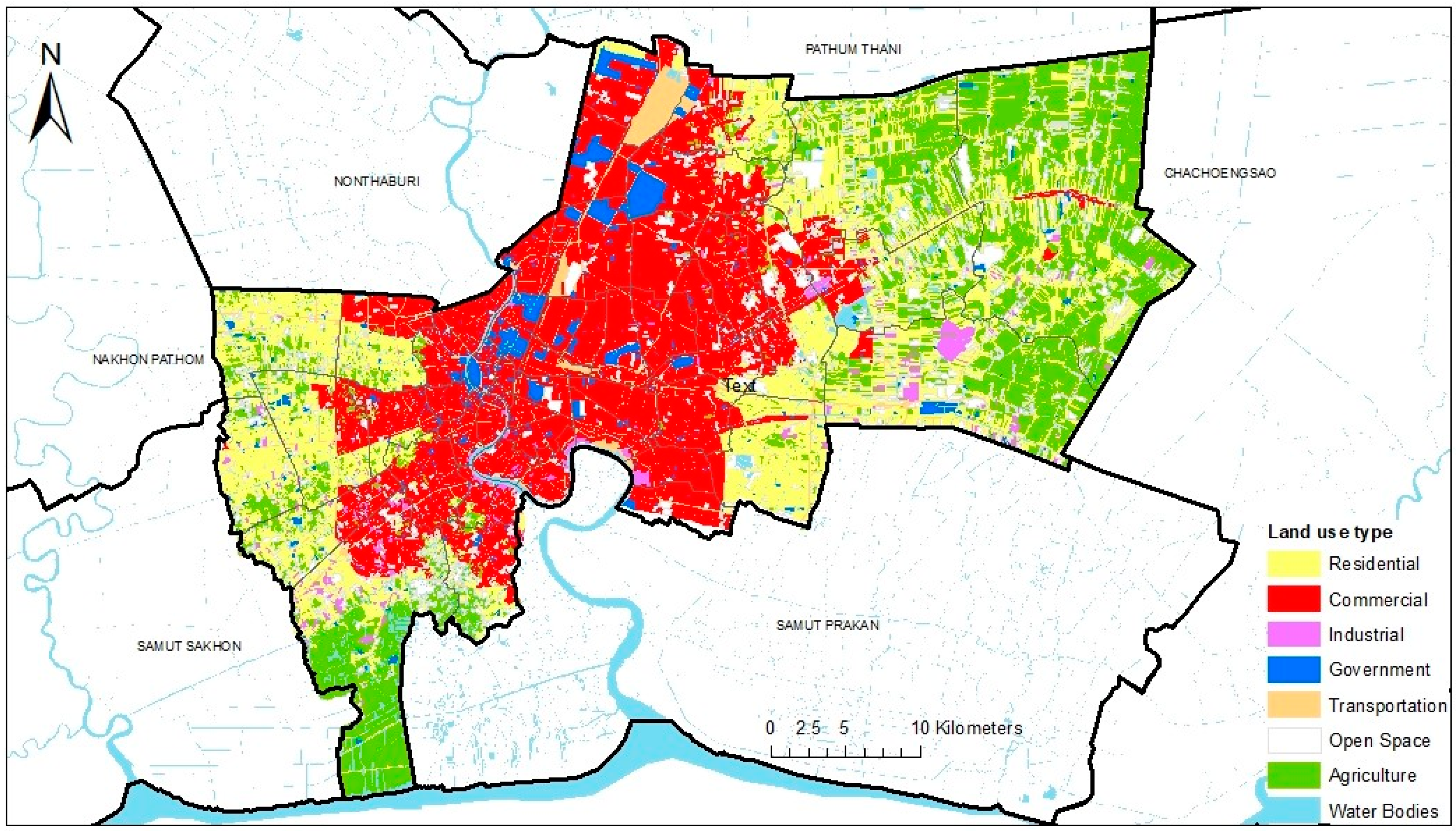
The 2019 land use data of Bangkok were provided by the Land Development Department, Ministry of Agriculture and Cooperatives. The land-use data were categorized into eight types: residential, commercial, industrial, government, transportation, open space, agriculture, and water bodies, as shown in Figure 2. The three most common land-use types in Bangkok are residential (31.60%), commercial (24.18%), and agricultural (23.68%).
The activities in the area surrounding monitoring stations affect the PM2.5 and PM10 concentrations. Hence, the areal sizes of all the land use types around the stations were calculated and used as inputs to the models. Buffer zones of radii 200, 400, 600, 800, and 1000 m from the monitoring stations were created. The land use areas intersecting each buffer zone were calculated and summarized by the land use type. The appropriate radial extent of each land use type from the stations may vary according to the different activities that affect PM2.5 and PM10 concentrations.
To acquire the appropriate radial extents of each land use type, correlations of the areas with 200, 400, 600, 800, and 1000 m radii with PM2.5 and with PM10 concentrations were tested. For each land-use type, the radius with the highest correlation, with a significance level of 0.05, was selected as the appropriate radius. The areal extent of the selected radius of each land-use type was input to the PM2.5 and PM10 LUR models.

2.1.4. Traffic Load

The traffic load was derived from a model developed by Sukitpaneenit and Stettler [28]. This model estimates the daily traffic count (vehicles/hour) of all vehicle types based on the relationship between traffic flow, traffic speed, and traffic density using data from the Global Positioning System receivers installed in 3000 taxis. The daily traffic count was translated into the traffic load of each road segment by multiplying the count with the length of each road segment (Equation (1)).
Traffic Load = Daily Traffic Count × Road Segment Length
Traffic load affects the PM2.5 and PM10 concentrations in the same way as land use. Therefore, the traffic load values within radii of 200, 400, 600, 800, and 1000 m from each station were tested to determine the appropriate radius with the highest correlation, with a significance level of 0.05, to the PM2.5 and PM10 concentrations. The traffic load values of the selected radius for PM2.5 and PM10 were input to the PM2.5 and PM10 LUR models, respectively.

2.2. LUR Model

As mentioned earlier, two LUR models were built, one each for PM2.5 and PM10. After selecting the predictor variables that were noncollinear with others and that were significant at the 0.05 level for PM2.5 or PM10 concentrations, the variables of each model were input into a multiple linear regression using the backward method in R program. Initially, all predictor variables were entered into a regression analysis; thereafter, one variable with the maximum p-value at a time was removed until all the variables remaining in the model were statistically significant. These remaining predictor variables and their coefficient values were used in the PM2.5 and PM10 LUR equations.
The two equations were then applied to estimate the PM2.5 and PM10 concentrations at any unmeasured location. The R2 values from each model indicate the percentage of variation in PM concentrations that can be explained by the predictors in the model.

2.3. Model Validation

K-fold CV in the R program was used to validate the stability of the obtained LUR models. Since all data were used to create the models, the data were sliced into 10 portions; among them, 9 portions were used as a training set and the remaining portion as a testing or validating set. The process was repeated 10 times, iterating through the training and testing sets, in the so-called 10-fold CV method, to obtain the mean squared error (MSE) of the 10-fold CV. The root mean squared error (RMSE) was then computed to determine the error (+/− µg/m3) in the model-estimated PM2.5 and PM10 concentrations.

2.4. Estimated PM2.5 and PM10 Concentration Map

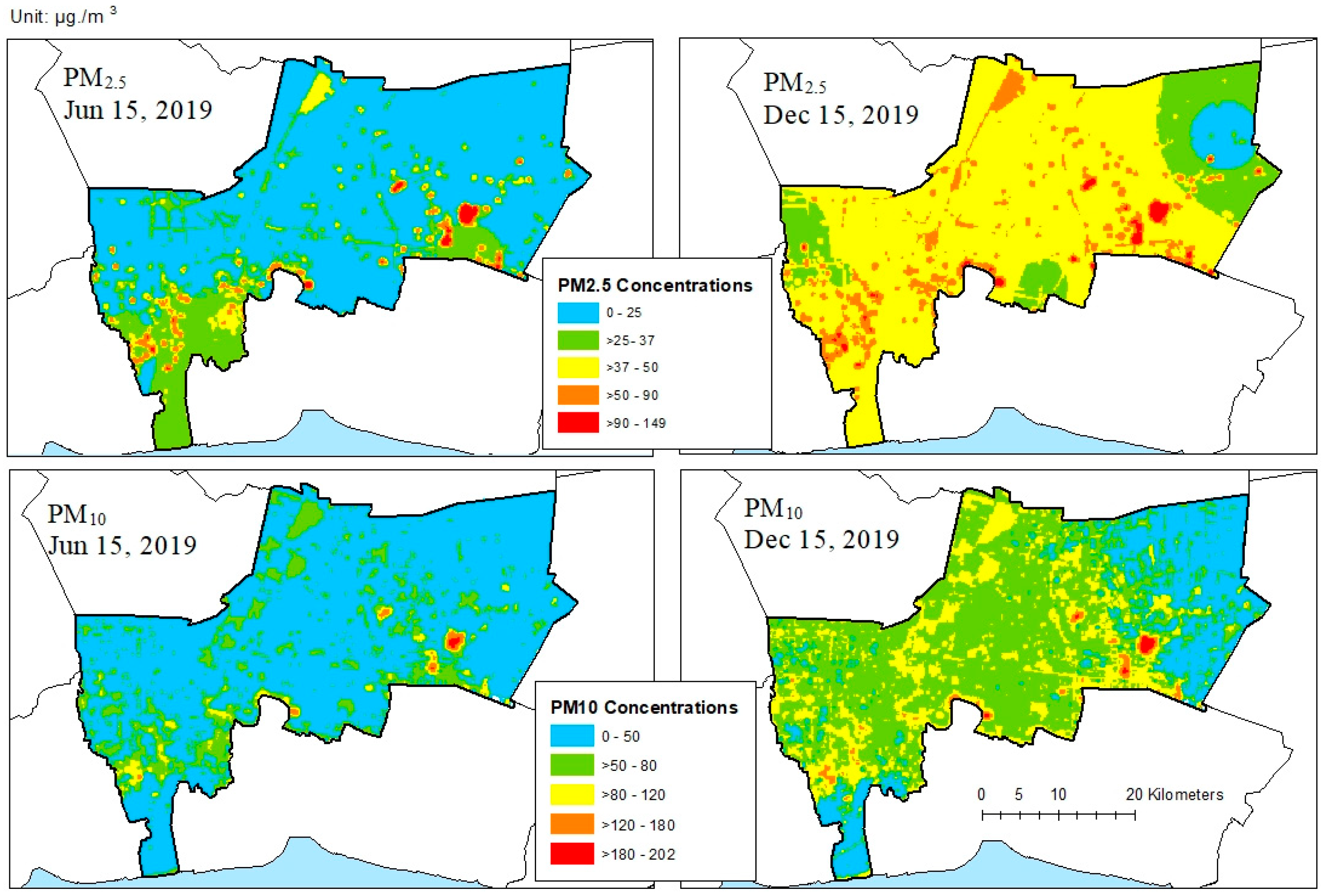
The equations derived from the PM2.5 and PM10 LUR models were applied to a 200 × 200 m grid covering Bangkok to reproduce estimated PM2.5 and PM10 concentration maps. Because the data for June and December 2019 were used in this research, the middle of each month (June 15 and December 15) was selected to generate the estimated PM2.5 and PM10 concentrations maps.
A vector grid of resolution 200 × 200 m was created to store the values of the variables in each LUR model. For meteorological data, the known values of the meteorological variables were measured only at the monitoring stations. Then, interpolation using the inverse distance weighted method was applied to acquire the values of grid cells at any unmeasured location. For land-use and traffic-load data, the areal extents of each required land-use type and the traffic load around the monitoring stations were obtained by buffering the grid cell centers with the selected radius and then calculating the area of each land-use type with the buffer zone.
When all the required values of the variables in the PM2.5 and PM10 LUR models were stored in each grid cell, the equation of each model was applied to estimate the PM2.5 and PM10 concentrations in Bangkok on 15 June and 15 December 2019.

3. Results

3.1. PM2.5

3.1.1. Variables Selection

The correlations of all the five meteorological variables with PM2.5 concentrations were statistically significant at the 0.01 level of significance (99% confidence; see Table 1). However, air pressure exhibited collinearly with temperature and relative humidity; therefore, only rainfall, wind speed, and air pressure were entered into the PM2.5 LUR model. Air pressure showed a high positive correlation with PM2.5 concentrations, whereas rainfall and wind speed showed low negative correlations with PM2.5 concentrations.
Six among the eight land-use types were statistically significant at the 0.05 level (95% confidence) and were selected as inputs to the PM2.5 LUR model. These six types were commercial, industrial, government, transportation, open space, and water bodies (Table 2). Residential and agricultural land-use types were excluded as they were not correlated with statistically significantly with PM2.5 concentrations. The data in Table 2 show that the selected radius for commercial and road areas were 200 m, for industrial and open space were 400 m, and for government and water bodies were 800 m. Commercial, industrial, and water bodies showed positive correlations, whereas government, open space, and road areas showed negative correlations. However, all the selected land use types showed very low correlation with PM2.5 concentrations.
Traffic load was not statistically significant correlated with the PM2.5 concentrations at any radius (Table 3). Therefore, this variable was excluded from the PM2.5 LUR model.

3.1.2. PM2.5 LUR Model

After variable selection, the PM2.5 LUR model consisted of three meteorological variables (rainfall, wind speed, and air pressure) and six land-use variables (commercial, industrial, governmental, road area, open space, green area, and water bodies). After applying backward stepwise regression in R program, only five variables were left in the PM2.5 LUR model, as shown in Equation (2).
PM 2.5 = 2949.0665 0.0948 Rainfall 13.4344 WindSpeed + 2.9583 AirPressure + 0.0002468 Ind 400 0.0001721 Trans 200
The adjusted R2 of the model was 0.58; in other words, the model could explain 58% of the variations in PM2.5 concentration. Equation (2) indicates that rainfall, wind speed, and transportation area were negatively correlated with the PM2.5 concentrations, whereas air pressure and industrial areas were positively correlated.

3.1.3. Validation

The results obtained by using 10-fold CV on the PM2.5 LUR model in the R program showed that the MSE was 95.5146 (RMSE = 9.77). Therefore, the model estimated that PM2.5 concentrations can have errors of about ±9.77 µg/m3.

3.2. PM10

3.2.1. Variable Selection

Only four meteorological variables, namely, rainfall, temperature, relative humidity, and air pressure, were statistically significant at the 0.01 level (99% confidence) as shown in Table 4. Similar to the case of the PM2.5 LUR model, air pressure exhibited collinearly with temperature and humidity; therefore, only rainfall and air pressure were entered into the PM10 LUR model. Rainfall was negatively correlated with the PM10 concentrations, whereas air pressure was positively correlated.
All land-use types were statistically correlated with the PM10 concentrations at a significance level of 0.05 (95% confidence), see Table 5. Therefore, all of them were used to create the PM10 LUR model. The residential, commercial, agricultural, and transportation areas were selected with a radius of 200 m from the monitoring stations. Government area and water bodies were selected with a radius of 400 m. Industrial area and open space were selected with radii of 600 and 800 m, respectively. Only commercial area and agriculture were negatively correlated, whereas the others were positively correlated with PM10 concentrations.
Traffic load within a radius of 400 m from the monitoring stations was the only buffer distance for which correlation with PM10 concentration was significant at the 0.05 level (Table 6). Therefore, it was included in the PM10 LUR model.

3.2.2. PM10 LUR Model

The PM10 LUR model was composed of two meteorological variables (rainfall and air pressure), eight land-use variables (residential, commercial, industrial, government, transportation, open space, agriculture, and water bodies), and traffic load. Then, backward stepwise regression analysis was used to fit a model (Equation (3)) with adjusted R2 at 0.57. That is, this model could explain 57% of the variations in PM10 concentration.
PM 10 = 5050.5599 0.1309 Rainfall + 5.0845 AirPressure 0.00022 Res 200 0.0002932 Com 200 + 0.0001149 Ind 600 0.0005785 Agric 200
The final PM10 LUR model had two meteorological variables and four land-use types. Government area, transportation area, open space, and water bodies were excluded from the model. The traffic load was also excluded. According to Equation (3), air pressure and industrial area were positively correlated with the PM10 concentrations, while the rest were negatively correlated.

3.2.3. Validation

Through 10-fold CV on the PM10 LUR model in R program, the MSE was obtained as 287.4693 (RMSE = 16.95). Therefore, the model-estimated PM10 concentrations can have errors of about ±16.95 µg/m3.

3.3. Estimated PM2.5 and PM10 Concentration Maps

The equations of the PM2.5 and PM10 LUR models were applied to estimate PM2.5 and PM10 concentrations on 15 June and 15 December, 2019 for the entirety of Bangkok. The estimated PM maps are shown in Figure 3. The concentrations were classified according to the standard classification of the Pollution Control Department. The maps show that the areas with high levels of PM that may affect human health were sparsely distributed.
With regard to PM2.5, most areas in Bangkok in June 2019 were classified as good and very good to human health, while in December 2019, most areas were classified as moderately harmful, which is harmful for vulnerable groups of people. There were more areas with high and very high levels of PM, which affect human health, in December than in June.
With regard to PM10, similar to PM2.5, most areas were very good for human health in June. In December, most of the areas were changed to good for human health or moderately harmful. Few spots had high and very high levels of PM10 concentrations.

4. Discussion

Based on previous studies, the factors used in the LUR models were varied to suit the characteristics of each study area. These factors are commonly related to transportation (such as road area, traffic load, and road length), land use (such as residential, commercial, industrial, agriculture, number of populations, and number of households), topography (such as distance from sea and elevation), and meteorological factors (such as rainfall, wind speed, temperature, and humidity) [9,15,17,26,27,28,29,30]. In this study, similar factors available within the study area, including traffic load, area of each land-use type, and meteorological data, were used. Compared with the previous research, the models built in this study have R2 values of 0.57 and 0.58 for PM2.5 and PM10 concentrations, respectively, indicating that the model can moderately explain the variations in the concentrations. The R2 values for PM2.5 of the previous research were in the ranges of 0.46 and 0.53 for the study areas of Bangkok [9] and Taichung, respectively, and 0.71 and 0.88 for the study areas in Xi-an and Shanghai, respectively [16,17,26,27].
The PM concentration levels are affected by seasons as the correlations between PM and meteorological factors were statistically higher than those between PM and land-use and traffic-load factors; this finding is similar to that of the study of Chalermpong et al. [9]. Although rainfall and air pressure influence both PM2.5 and PM10 concentrations, a wind speed of about 1–2 m/s in Bangkok significantly affected only PM2.5 concentrations. The different influence of wind speed on PM2.5 and PM10 were also mentioned in Pengchan et al. [31], i.e., that stronger wind could blow fine PM far away and, simultaneously, re-suspend coarse PM from the ground up in the air. Moreover, Liu et al. [32] also reported the different effects of wind speed on the concentrations of PM2.5 and PM10. They revealed that wind speed greater than 2 m/s decreased the concentration of PM2.5 and PM10, and wind speed greater than 4 m/s increased the concentration of PM10. As wind speed in Bangkok is lower than in the study area of Liu et al. [32], the finding from this study reveals that wind speed of 1–2 m/s caused PM2.5 to increase but not strong enough on PM10 to see a pattern or relationship.
This study did not include wind direction in the analysis, although some previous studies mentioned that long-range transport affect the concentrations of PM along the wind pathway [33,34,35]. Li et al. [34] introduced the semicircular-buffer-based LUR model to incorporate wind direction in the LUR model and reported that including wind direction in their LUR model yielded better results than traditional LUR. Furthermore, Wimolwattanapun et al. [35] found that wind speed and direction helped in identifying the PM sources and each source was influenced by the wind in the same direction at their study sites in Bangkok and Pathumthani. Therefore, in our further study, wind direction should be included in the LUR modeling to cover the long-range transport issue.
Shi et al. [15] stated that main road length and distance to road affected PM concentrations; however, in this study, a road area within 200 m from the measurement point affected only PM2.5 concentrations and showed a negative relationship with the PM. Traffic load was also excluded from the models, suggesting that transportation-related factors may not be the main contribution to the PM concentrations in Bangkok. Likewise, Han et al. [26] also mentioned that the emission from traffic had less contribution to PM concentrations than the contribution from industries.
Land-use types are expected to influence the PM concentrations as it is known that some land-use types such as industrial areas are a source of pollution while some others such as agricultural area are not. This study revealed that the correlations between each land-use type and the PM concentrations were quite low. In addition, only some land-use types were included in the models. Industrial areas within 400–600 m comprised the main land-use type that contributed to both PM2.5 and PM10 concentrations. In contrast, residential, commercial, and agriculture areas within 200 m affected only the PM10 concentrations.
The RMSE values obtained by CV in this study are comparable to those reported by Han et al. [26]. In this study, the RMSEs were ±9.77 for the PM2.5 model and ±16.95 for the PM10 model, while those reported by Han et al. [26] were ±8.35 for the PM2.5 model and ±14.84 for the PM10 model.
The reproduced maps of the estimated PM2.5 and PM10 concentrations in Bangkok showed that the model can help identify locations that require measures to safeguard human health even in the absence of monitoring stations there. The maps also revealed that Bangkok was more affected by PM2.5 than by PM10 as in December, most areas were regarded to have moderately harmful PM2.5 levels but the PM10 level was considered to be within the limit of good for human health.

5. Conclusions

To summarize, an LUR approach was adopted in this study to estimate the PM2.5 and PM10 concentrations in Bangkok. Researches conducted across the world based on this approach have revealed that the models comprise different factors and different coefficients of such factors depending on the study areas. This study revealed that meteorological factors are strongly related to PM concentrations, and that the industrial area is a source of PM2.5 and PM10 pollutants. The models yielded R2 values of about 0.57–0.58, which is within the range reported in previous research. In further study, using daily PM and meteorological data of the whole year can help improve the models as the present results indicated that meteorological data play an important role in determining the PM concentrations in Bangkok.

Author Contributions

Writing—original draft preparation, P.C., C.D. and M.S.; writing—review and editing, M.E.J.S. All authors have read and agreed to the published version of the manuscript.

Funding

This research was funded by Ratchadapiseksompotch Fund Chulalongkorn University, grant number CU_GR_63_26_22_01. The APC was also funded by Chulalongkorn University.

Institutional Review Board Statement

The study was conducted in accordance with the Declaration of Helsinki and approved by the Research Ethics Review Committee for Research Involving Human Research Participants, Group 1 of Chulalongkorn University (protocol code 121/2020 and 19 May 2020).

Informed Consent Statement

Not applicable.

Data Availability Statement

The data presented in this study are available on request from the corresponding author. Data was obtained from Bangkok Metropolitan Authority, Land Development Department (Ministry of Agriculture and Cooperatives), and ICT Center (Ministry of Transportation).

Acknowledgments

The authors would like to thank the Bangkok Metropolitan Authority, Land Development Department (Ministry of Agriculture and Cooperatives), and ICT Center (Ministry of Transportation) for the data used in this study. We are grateful to the Office of Research Affairs, Chulalongkorn University to support our Geography and Geoinformation Research Unit to conduct this research.

Conflicts of Interest

The authors declare no conflict of interest.

References

  1. Shi, Y.; Zhao, A.; Matsunaga, T.; Yamaguchi, Y.; Zang, S.; Li, Z.; Yu, T.; Gu, X. Underlying causes of PM2.5-induced premature mortality and potential health benefits of air pollution control in South and Southeast Asia from 1999 to 2014. Environ. Int. 2018, 121, 814–823. [Google Scholar] [CrossRef] [PubMed]
  2. WHO. Ambient (Outdoor) Air Pollution. Available online: https://www.who.int/en/news-room/fact-sheets/detail/ambient-(outdoor)-air-quality-and-health (accessed on 2 February 2022).
  3. Buadong, D.; Jinsart, W.; Funatagawa, I.; Karita, K.; Yano, E. Association between PM10 and O3 levels and hospital visits for cardiovascular diseases in Bangkok, Thailand. J. Epidemiol. 2009, 19, 182–188. [Google Scholar] [CrossRef] [PubMed] [Green Version]
  4. Phosri, A.; Ueda, K.; Phung, V.L.H.; Tawatsupa, B.; Honda, A.; Takano, H. Effects of ambient air pollution on daily hospital admissions for respiratory and cardiovascular diseases in Bangkok, Thailand. Sci. Total Environ. 2019, 651, 1144–1153. [Google Scholar] [CrossRef] [PubMed]
  5. Ostro, B.; Chestnut, L.; Vichit-Vadakan, N.; Laixuthai, A. The Impact of Particulate Matter on Daily Mortality in Bangkok, Thailand. J. Air Waste Manag. Assoc. 2011, 49, 100–107. [Google Scholar] [CrossRef] [Green Version]
  6. Vajanapoom, N.; Shy, C.M.; Neas, L.M.; Loomis, D. Associations of particulate matter and daily mortality in Bangkok, Thailand. Southeast Asian J. Trop. Med. Public Health 2002, 33, 389–399. [Google Scholar]
  7. Vichit-Vadakan, N.; Vajanapoom, N.; Ostro, B. Part 3. Estimating the effects of air pollution on mortality in Bangkok, Thailand. In Research Report; Health Effects Institute: Boston, MA, USA, 2010; pp. 231–268. [Google Scholar]
  8. Cheewinsiriwat, P. Estimation of nitrogen dioxide concentrations in Inner Bangkok using Land Use Regression modeling and GIS. Appl. Geomat. 2016, 8, 107–116. [Google Scholar] [CrossRef]
  9. Chalermpong, S.; Thaithatkul, P.; Anuchitchanchai, O.; Sanghatawatana, P. Land use regression modeling for fine particulate matters in Bangkok, Thailand, using time-variant predictors: Effects of seasonal factors, open biomass burning, and traffic-related factors. Atmos. Environ. 2021, 246, 118128. [Google Scholar] [CrossRef]
  10. Briggs, D.J.; Collins, S.; Elliott, P.; Fischer, P.; Kingham, S.; Lebret, E.; Pryl, K.; Van Reeuwijk, H.; Smallbone, K.; Van Der Veen, A. Mapping urban air pollution using GIS: A regression-based approach. Int. J. Geogr. Inf. Sci. 1997, 11, 699–718. [Google Scholar] [CrossRef] [Green Version]
  11. Hoek, G.; Beelen, R.; de Hoogh, K.; Vienneau, D.; Gulliver, J.; Fischer, P.; Briggs, D. A review of land-use regression models to assess spatial variation of outdoor air pollution. Atmos. Environ. 2008, 42, 7561–7578. [Google Scholar] [CrossRef]
  12. Beelen, R.; Hoek, G.; Vienneau, D.; Eeftens, M.; Dimakopoulou, K.; Pedeli, X.; Tsai, M.-Y.; Künzli, N.; Schikowski, T.; Marcon, A.; et al. Development of NO2 and NOx land use regression models for estimating air pollution exposure in 36 study areas in Europe–The ESCAPE project. Atmos. Environ. 2013, 72, 10–23. [Google Scholar] [CrossRef]
  13. Lee, J.-H.; Wu, C.-F.; Hoek, G.; de Hoogh, K.; Beelen, R.; Brunekreef, B.; Chan, C.-C. LUR models for particulate matters in the Taipei metropolis with high densities of roads and strong activities of industry, commerce and construction. Sci. Total Environ. 2015, 514, 178–184. [Google Scholar] [CrossRef] [PubMed]
  14. Liu, W.; Li, X.; Chen, Z.; Zeng, G.; León, T.; Liang, J.; Huang, G.; Gao, Z.; Jiao, S.; He, X.; et al. Land use regression models coupled with meteorology to model spatial and temporal variability of NO2 and PM10 in Changsha, China. Atmos. Environ. 2015, 116, 272–280. [Google Scholar] [CrossRef]
  15. Shi, T.; Hu, Y.; Liu, M.; Li, C.; Zhang, C.; Liu, C. Land use regression modelling of PM2.5 spatial variations in different seasons in urban areas. Sci. Total Environ. 2020, 743, 140744. [Google Scholar] [CrossRef]
  16. Liu, C.; Henderson, B.H.; Wang, D.; Yang, X.; Peng, Z.R. A land use regression application into assessing spatial variation of intra-urban fine particulate matter (PM2.5) and nitrogen dioxide (NO2) concentrations in City of Shanghai, China. Sci. Total Environ. 2016, 565, 607–615. [Google Scholar] [CrossRef] [PubMed]
  17. Chang, T.-Y.; Tsai, C.-C.; Wu, C.-F.; Chang, L.-T.; Chuang, K.-J.; Chuang, H.-C.; Young, L.-H. Development of land-use regression models to estimate particle mass and number concentrations in Taichung, Taiwan. Atmos. Environ. 2021, 252, 118303. [Google Scholar] [CrossRef]
  18. Fritsch, M.; Behm, S. Agglomeration and infrastructure effects in land use regression models for air pollution–Specification, estimation, and interpretations. Atmos. Environ. 2021, 253, 118337. [Google Scholar] [CrossRef]
  19. Lee, J.-H.; Wu, C.-F.; Hoek, G.; de Hoogh, K.; Beelen, R.; Brunekreef, B.; Chan, C.-C. Land use regression models for estimating individual NOx and NO2 exposures in a metropolis with a high density of traffic roads and population. Sci. Total Environ. 2014, 472, 1163–1171. [Google Scholar] [CrossRef]
  20. Sahsuvaroglu, T.; Arain, A.; Kanaroglou, P.; Finkelstein, N.; Newbold, B.; Jerrett, M.; Beckerman, B.; Brook, J.; Finkelstein, M.; Gilbert, N.L. A Land Use Regression Model for Predicting Ambient Concentrations of Nitrogen Dioxide in Hamilton, Ontario, Canada. J. Air Waste Manag. Assoc. 2012, 56, 1059–1069. [Google Scholar] [CrossRef] [Green Version]
  21. Chen, L.; Bai, Z.; Kong, S.; Han, B.; You, Y.; Ding, X.; Du, S.; Liu, A. A land use regression for predicting NO2 and PM10 concentrations in different seasons in Tianjin region, China. J. Environ. Sci. 2010, 22, 1364–1373. [Google Scholar] [CrossRef]
  22. Dirgawati, M.; Barnes, R.; Wheeler, A.J.; Arnold, A.-L.; McCaul, K.A.; Stuart, A.L.; Blake, D.; Hinwood, A.; Yeap, B.B.; Heyworth, J.S. Development of Land Use Regression models for predicting exposure to NO2 and NOx in Metropolitan Perth, Western Australia. Environ. Model. Softw. 2015, 74, 258–267. [Google Scholar] [CrossRef]
  23. Wolf, K.; Cyrys, J.; Harciníková, T.; Gu, J.; Kusch, T.; Hampel, R.; Schneider, A.; Peters, A. Land use regression modeling of ultrafine particles, ozone, nitrogen oxides and markers of particulate matter pollution in Augsburg, Germany. Sci. Total Environ. 2017, 579, 1531–1540. [Google Scholar] [CrossRef] [PubMed] [Green Version]
  24. Khreis, H.; de Hoogh, K.; Nieuwenhuijsen, M.J. Full-chain health impact assessment of traffic-related air pollution and childhood asthma. Environ. Int. 2018, 114, 365–375. [Google Scholar] [CrossRef] [PubMed]
  25. Wu, J.; Li, J.; Peng, J.; Li, W.; Xu, G.; Dong, C. Applying land use regression model to estimate spatial variation of PM2.5 in Beijing, China. Environ. Sci. Pollut. Res. 2015, 22, 7045–7061. [Google Scholar] [CrossRef]
  26. Han, L.; Zhao, J.; Gao, Y.; Gu, Z.; Xin, K.; Zhang, J. Spatial distribution characteristics of PM2.5 and PM10 in Xi’an City predicted by land use regression models. Sustain. Cities Soc. 2020, 61, 102329. [Google Scholar] [CrossRef] [PubMed]
  27. Mo, Y.; Booker, D.; Zhao, S.; Tang, J.; Jiang, H.; Shen, J.; Chen, D.; Li, J.; Jones, K.C.; Zhang, G. The application of land use regression model to investigate spatiotemporal variations of PM2.5 in Guangzhou, China: Implications for the public health benefits of PM2.5 reduction. Sci. Total Environ. 2021, 778, 146305. [Google Scholar] [CrossRef] [PubMed]
  28. Sukitpaneenit, M.; Stettler, M. High spatial resolution traffic flow and emissions based on taxi GPS data in Bangkok, Thailand. In Proceedings of the ERSA 2019, Lyon, France, 29 August 2019; p. 405. [Google Scholar]
  29. Wong, P.Y.; Lee, H.Y.; Chen, Y.C.; Zeng, Y.T.; Chern, Y.R.; Chen, N.T.; Candice Lung, S.C.; Su, H.J.; Wu, C.D. Using a land use regression model with machine learning to estimate ground level PM2.5. Environ. Pollut. 2021, 277, 116846. [Google Scholar] [CrossRef]
  30. Tai, A.P.K.; Mickley, L.J.; Jacob, D.J. Correlations between fine particulate matter (PM2.5) and meteorological variables in the United States: Implications for the sensitivity of PM2.5 to climate change. Atmos. Environ. 2010, 44, 3976–3984. [Google Scholar] [CrossRef]
  31. Pengjan, S.; Fan, C.; Bonnet, S.; Garivait, S. Assessment of the PM2.5/PM10 ratio in the Bangkok Metropolitan Region during 2011–2017. J. Sustain. Energy Environ. 2019, 10, 75–84. [Google Scholar]
  32. Liu, Z.; Shen, L.; Yan, C.; Du, J.; Li, Y.; Zhao, H. Analysis of the influence of precipitation and wind on PM2.5 and PM10 in the atmosphere. Adv. Meteorol. 2020, 2020, 5039613. [Google Scholar] [CrossRef]
  33. Banerjee, P.; Satheesh, S.K.; Moorthy, K.K.; Nanjundiah, R.S.; Nair, V.S. Long-range transport of mineral dust to the northeast Indian Ocean: Regional versus remote sources and the implications. J. Clim. 2019, 32, 1525–1549. [Google Scholar] [CrossRef]
  34. Li, X.; Liu, W.; Chen, Z.; Zeng, G.; Hu, C.; León, T.; Liang, J.; Huang, G.; Gao, Z.; Li, Z.; et al. The application of semicircular-buffer-based land use regression models incorporating wind direction in predicting quarterly NO2 and PM10 concentrations. Atmos. Environ. 2015, 103, 18–24. [Google Scholar] [CrossRef]
  35. Wimolwattanapun, W.; Hopke, P.K.; Pongkiatkul, P. Source apportionment and potential source locations of PM2.5 and PM2.5–10 at residential sites in metropolitan Bangkok. Atmos. Pollut. Res. 2011, 2, 172–181. [Google Scholar] [CrossRef] [Green Version]
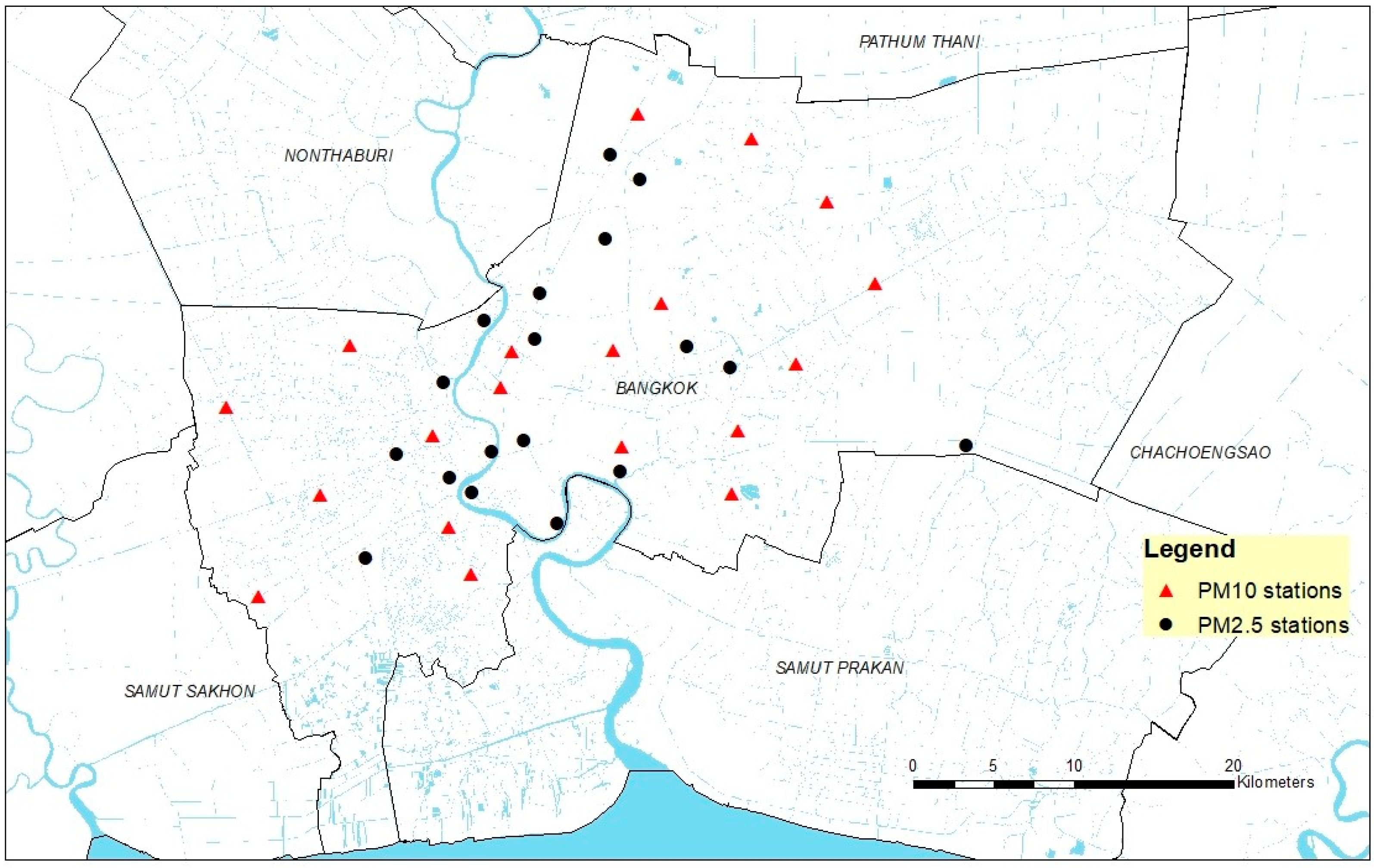
Figure 1. PM2.5 and PM10 monitoring stations whose data were used in the model. Basemap data from the Ministry of Transportation, and the monitoring station coordinates from Bangkok Metropolitan Authority.
Sustainability 14 05367 g001
Figure 2. Land use map of Bangkok for the year 2019. Land-use data from the Land Development Department.
Sustainability 14 05367 g002
Figure 3. Estimated PM2.5 and PM10 concentrations maps for 15 June and 15 December 2019 in Bangkok.
Sustainability 14 05367 g003
Table 1. Correlations between the meteorological variables and PM2.5 concentrations.
RainfallWind SpeedTemperatureHumidityAir Pressure
PM2.5
Concentration
−0.218 **−0.295 **−0.475 **−0.557 **0.711 **
** Correlation is significant at the 0.01 level (2-tailed).
Table 2. Correlations between the land use types and PM2.5 concentrations and the selected radius from the monitoring stations.
Land Use TypeSelected Radius from the Monitoring StationsCorrelation
ResidentialN/ANot significant at 0.05
Commercial2000.070 *
Industrial4000.096 **
Government800−0.078 *
Transportation200−0.065 *
Open Space400−0.093 **
AgricultureN/ANot significant at 0.05
Water Bodies8000.110 **
** Correlationis significant at the 0.01 level (2-tailed). * Correlation is significant at the 0.05 level (2-tailed).
Table 3. Correlations between traffic loads with different radii from the monitoring stations and PM2.5 concentrations.
Radius from the Monitoring Stations
2004006008001000
PM2.5
Concentration
−0.049−0.055−0.016−0.0160.023
Table 4. Correlations between the meteorological variables and PM10 concentrations.
RainfallWind SpeedTemperatureHumidityAir Pressure
PM10
Concentration
−0.221 **−0.032−0.469 **−0.563 **0.682 **
** Correlation is significant at the 0.01 level (2-tailed).
Table 5. Correlations between the land-use types and PM10 concentrations and selected radius from the monitoring stations.
Land Use TypeSelected Radius from the Monitoring StationsCorrelation
Residential2000.115 **
Commercial200−0.119 **
Industrial6000.163 **
Government4000.102 **
Transportation2000.073 *
Open Space8000.117 **
Agriculture200−0.158 **
Water Bodies4000.080 **
** Correlation is significant at the 0.01 level (2-tailed). * Correlation is significant at the 0.05 level (2-tailed).
Table 6. Correlations between traffic loads within different radii from the monitoring stations and PM10 concentrations.
Radius from the Monitoring Stations
2004006008001000
PM10
Concentration
−0.040−0.065 *0.053−0.0200.059
* Correlation is significant at the 0.05 level (2-tailed).
Publisher’s Note: MDPI stays neutral with regard to jurisdictional claims in published maps and institutional affiliations.