
Impact of Land Cover Changes on the Availability of Water Resources in the Regional Natural Park Serranía de Las Quinchas

 and
and 
Abstract
:1. Introduction
2. Literature Review
3. Overview
3.1. SWAT Model
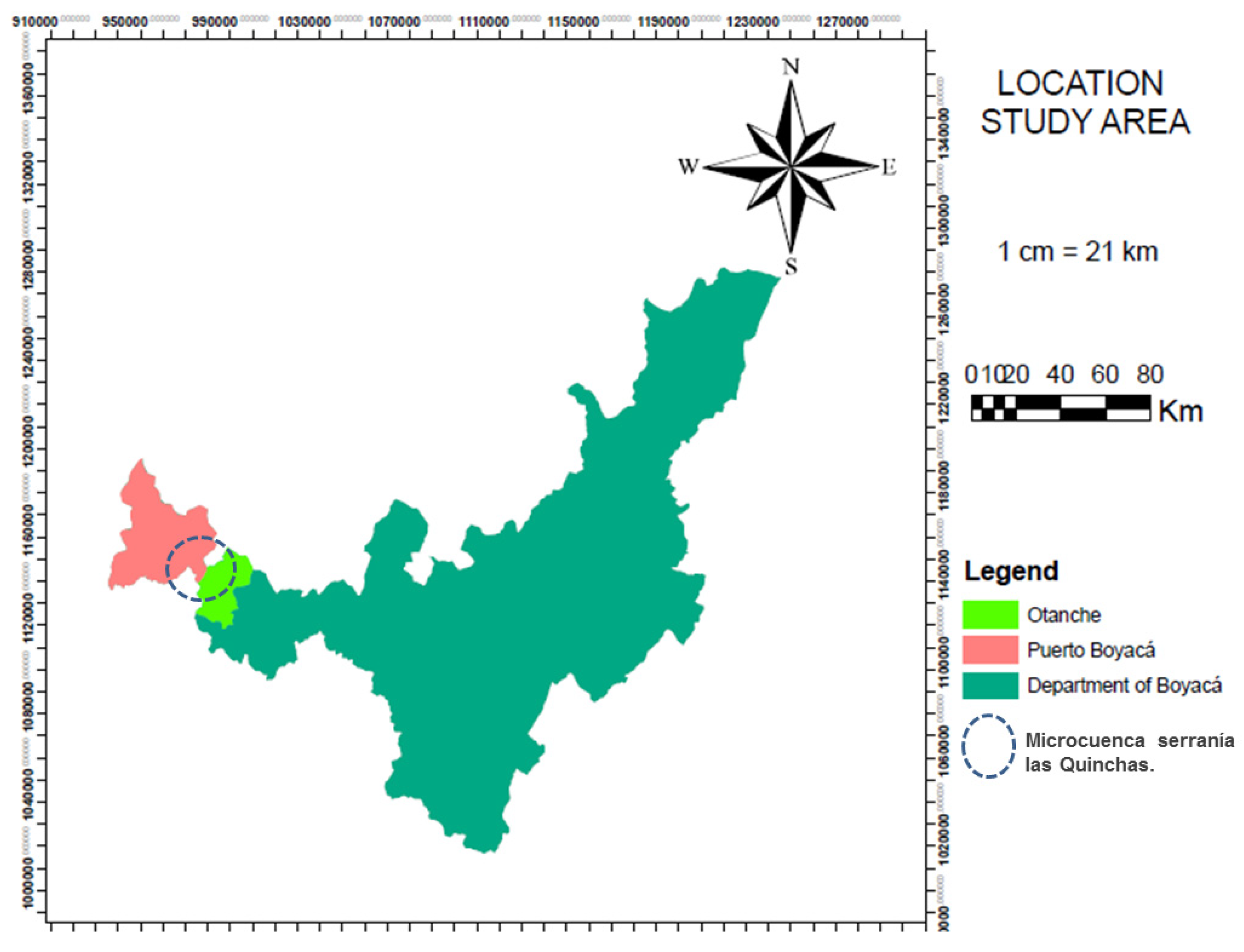
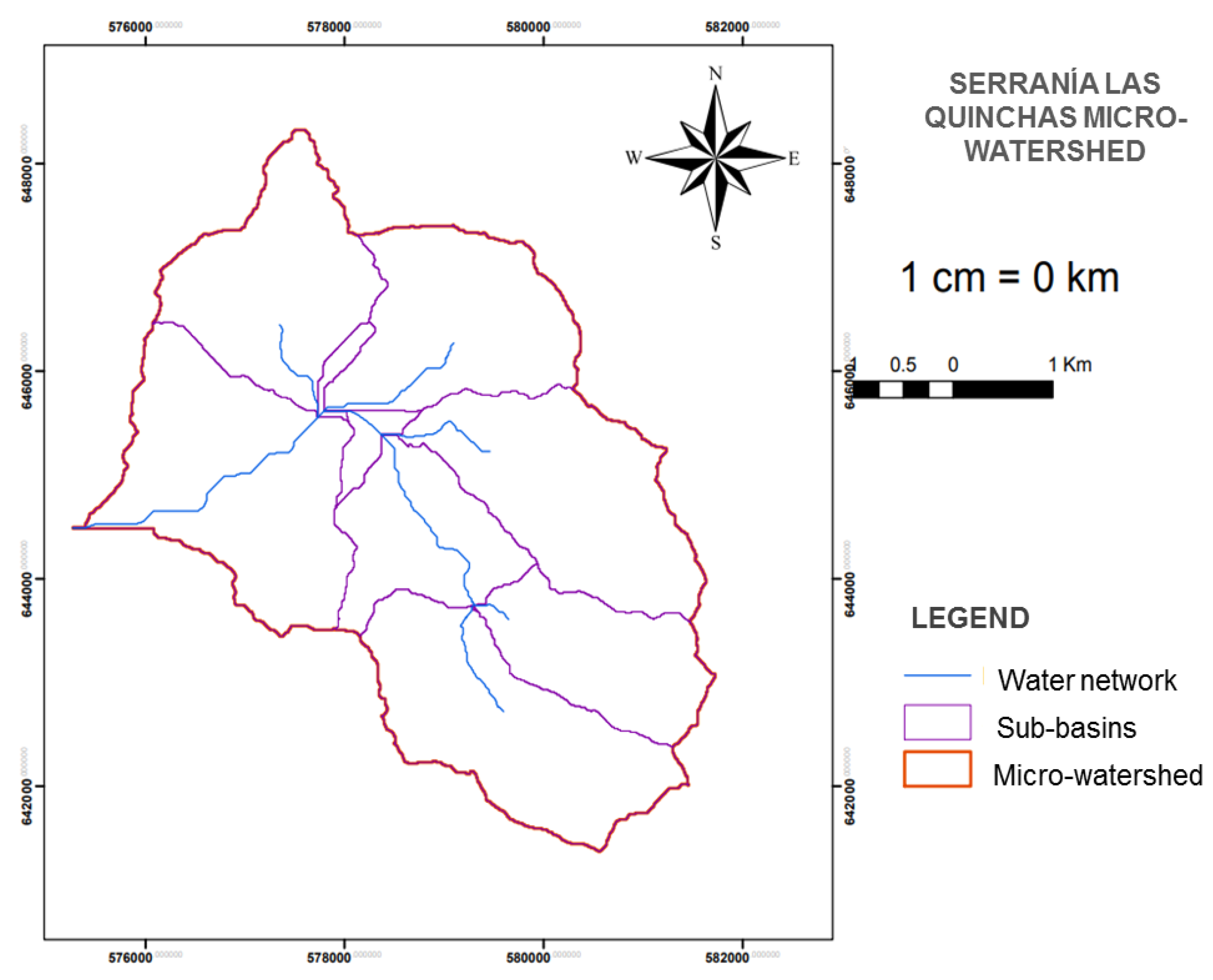
3.2. Study Area
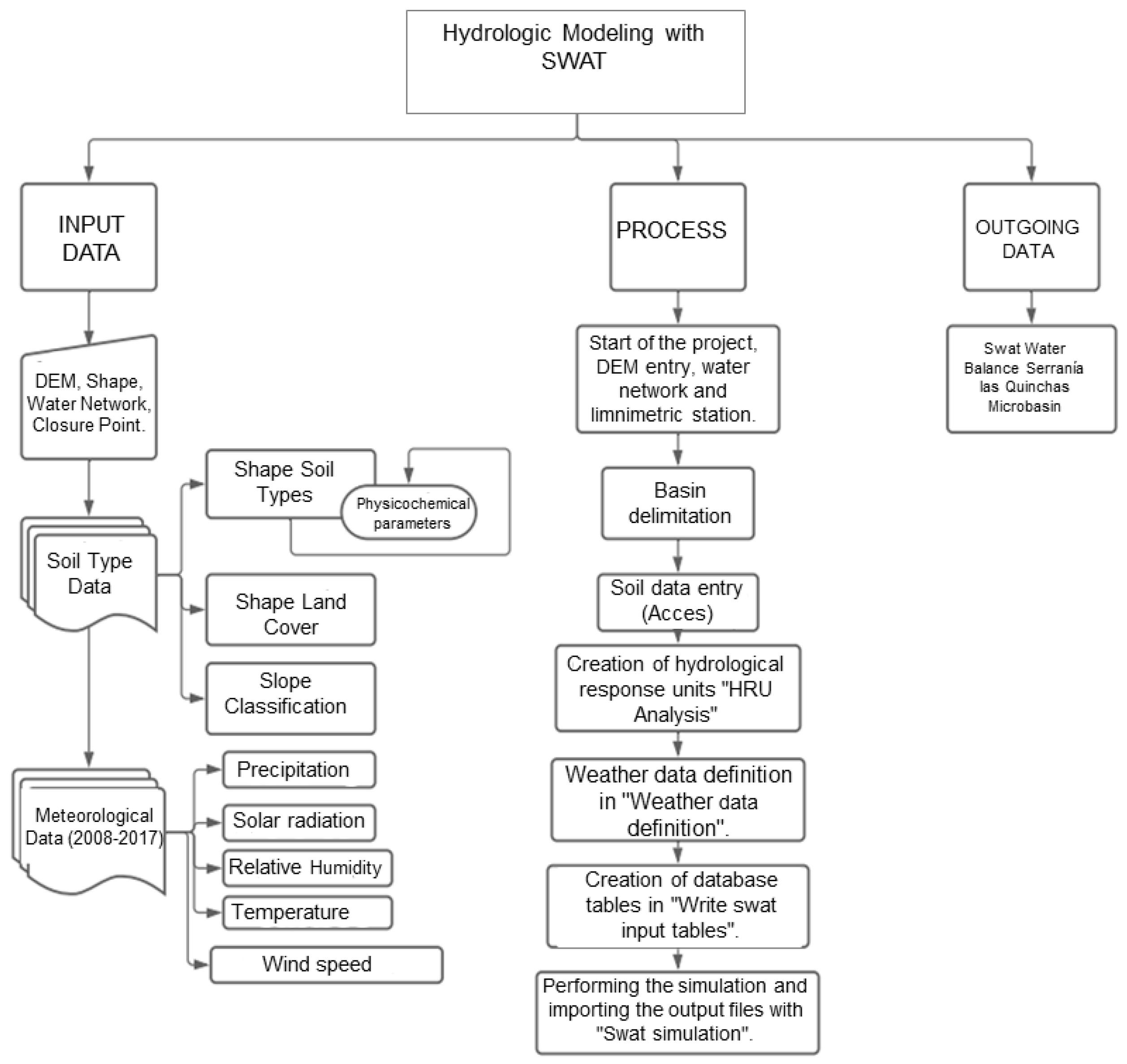
4. Materials and Methods
4.1. Primary Data Review
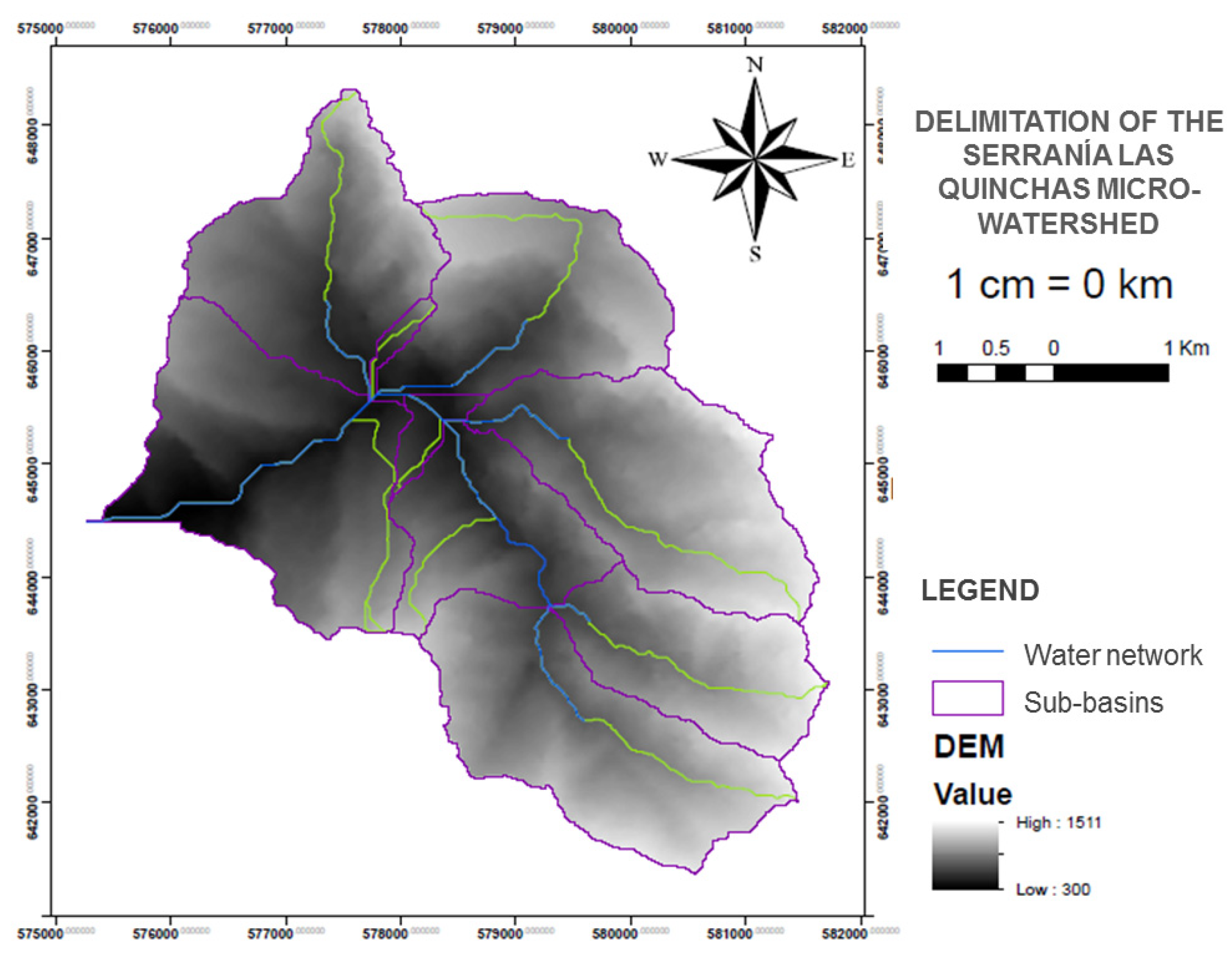
4.2. Delimitation of the Study Area
4.3. Preparation of SWAT Model Input Data
4.3.1. Hydrometeorological Data Processing
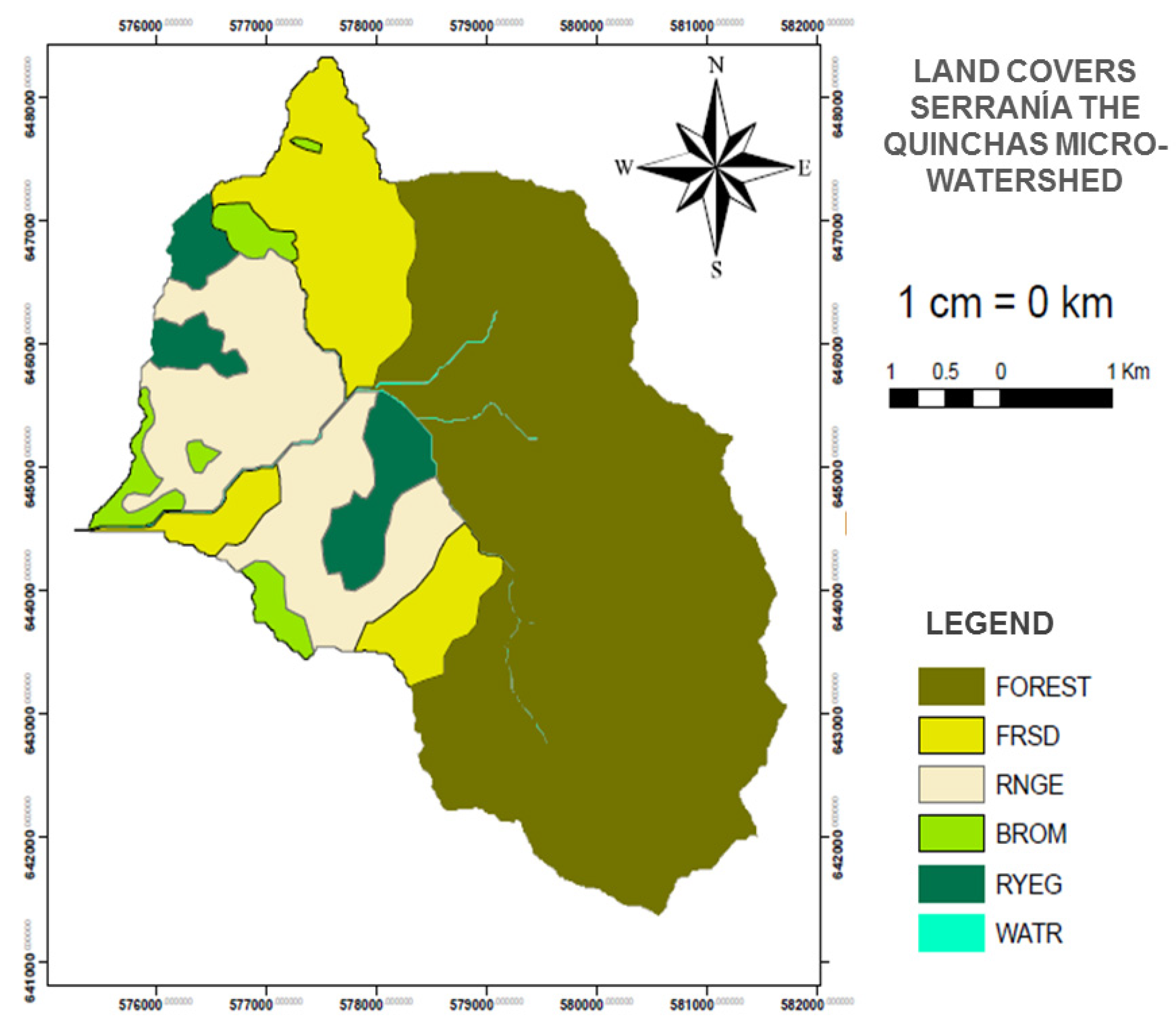
4.3.2. Land Processing
4.3.3. Hedge Processing
4.3.4. SWAT Model Application
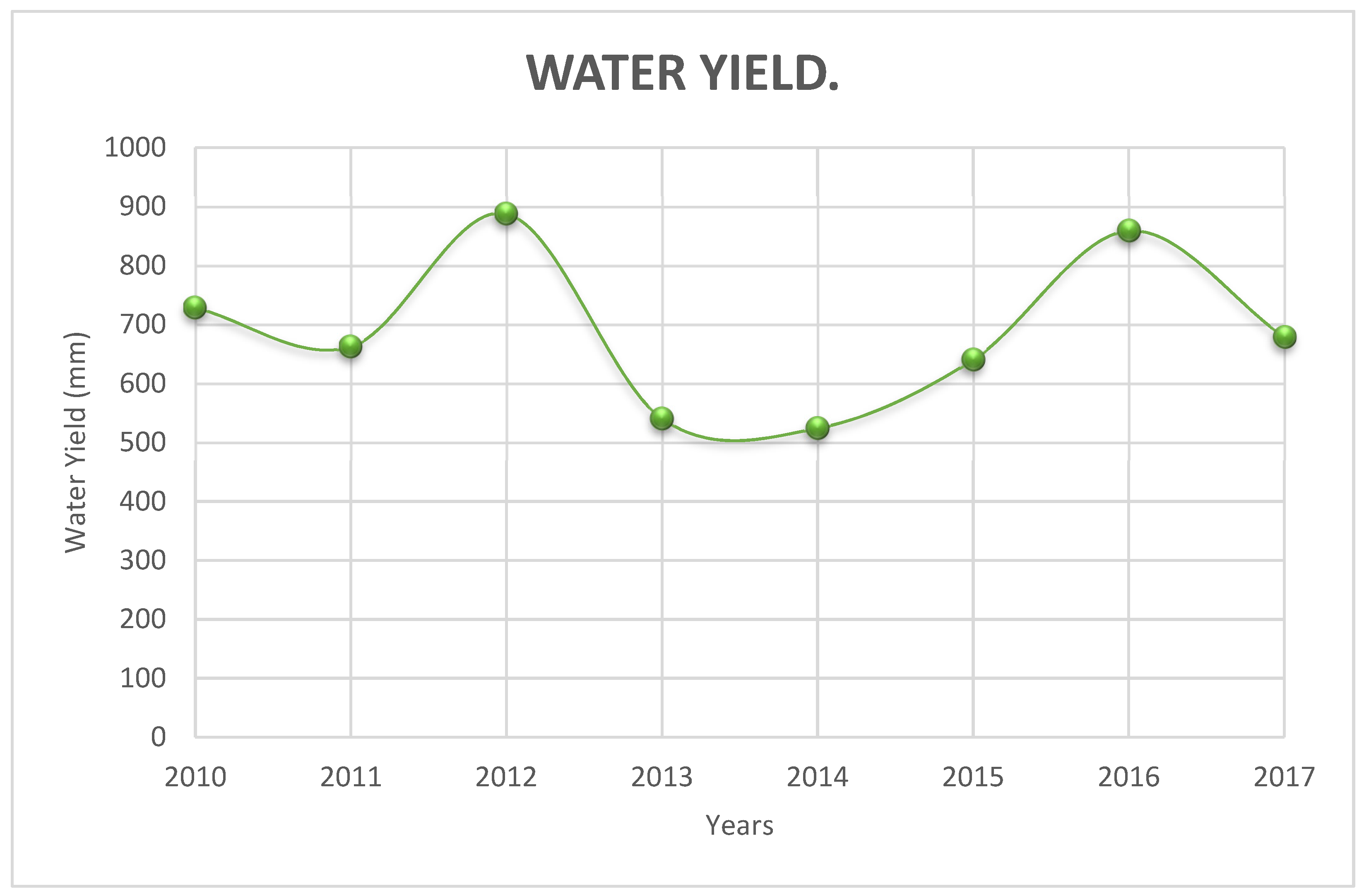
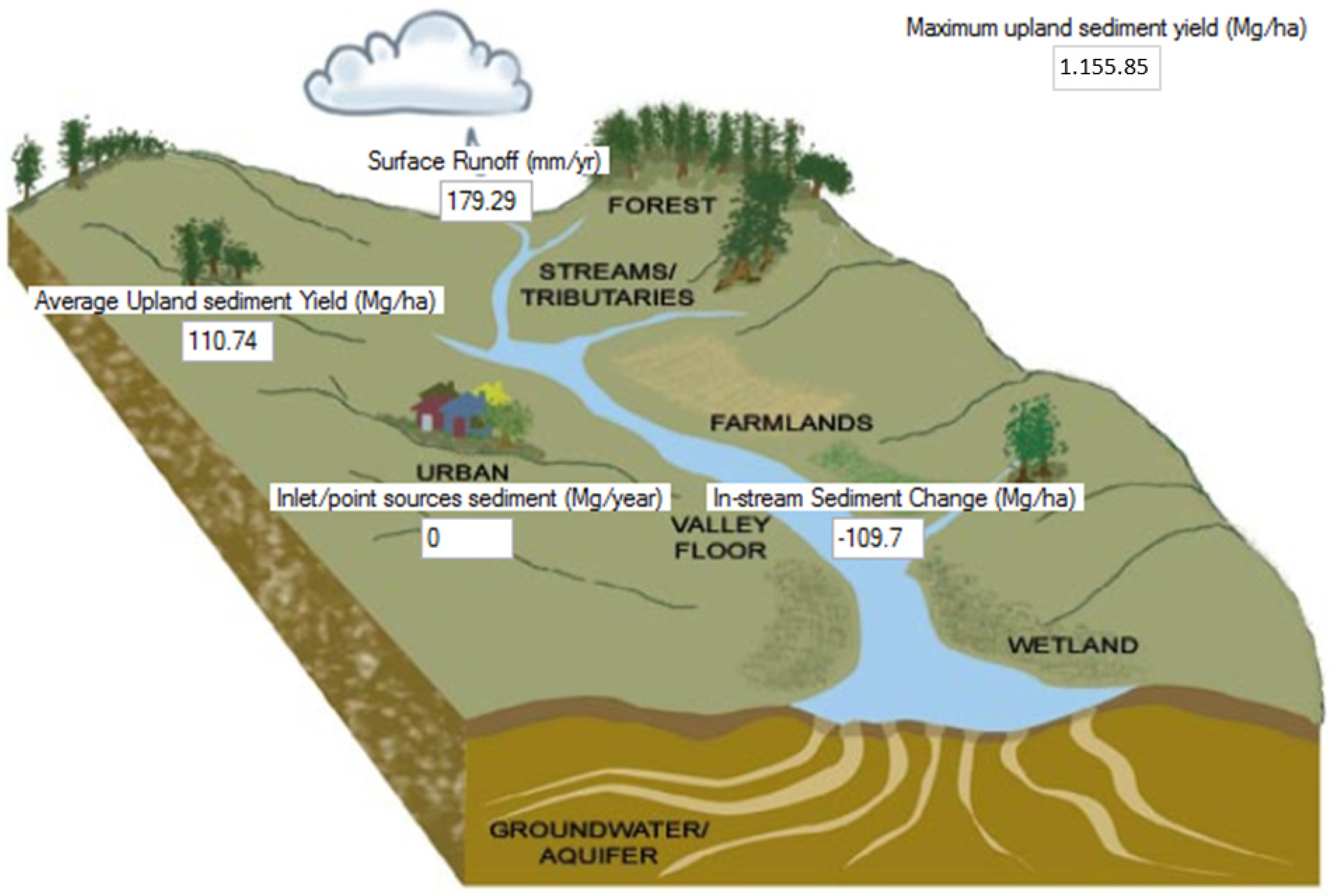
5. Results
6. Discussion and Conclusions
Author Contributions
Funding
Institutional Review Board Statement
Informed Consent Statement
Data Availability Statement
Conflicts of Interest
References
- Leemhuis, C.; Thonfeld, F.; Näschen, K.; Steinbach, S.; Muro, J.; Strauch, A.; López, A.; Daconto, G.; Games, I.; Diekkrüger, B. Sustainability in the food-water-ecosystem nexus: The role of land use and land cover change for water resources and ecosystems in the Kilombero Wetland, Tanzania. Sustainability 2017, 9, 1513. [Google Scholar] [CrossRef] [Green Version]
- Delgado, J.; Llorens, P.; Nord, G.; Calder, I.R.; Gallart, F. Modelling the hydrological response of a Mediterranean medium-sized headwater basin subject to land cover change: The Cardener River basin (NE Spain). J. Hydrol. 2010, 383, 125–134. [Google Scholar] [CrossRef]
- Hyandye, C.B.; Worqul, A.; Martz, L.W.; Muzuka, A.N.N. The impact of future climate and land use/cover change on water resources in the Ndembera watershed and their mitigation and adaptation strategies. Environ. Syst. Res. 2018, 7, 7. [Google Scholar] [CrossRef] [Green Version]
- Dwarakish, G.S.; Ganasri, B.P. Impact of land use change on hydrological systems: A review of current modeling approaches. Cogent Geosci. 2015, 1, 1115691. [Google Scholar] [CrossRef]
- Corpoboyaca. Acuerdo 028 de 2008. Por el cual se Declara y alindera el Parque Natural Regional Serranía de Las Quinchas, en los Municipios de Otanche y Puerto Boyacá en el Departamento de Boyacá; Corpoboyaca: Tunja, Colombia, 2008. [Google Scholar]
- Sistema Regional de Áreas Protegidas PNR Las Quinchas. Available online: https://www.corpoboyaca.gov.co/sirap/areas-protegidas/regionales/las-quinchas/ (accessed on 9 November 2021).
- Pérez, M.; Fernández, L.; Alegre, F. Planificación en territorios rurales. Proyección 2009, 1, 1–21. [Google Scholar]
- Parajka, J.; Naeimi, V.; Blöschl, G.; Wagner, W.; Merz, R.; Scipal, K. Assimilating scatterometer soil moisture data into conceptual hydrologic models at the regional scale. Hydrol. Earth Syst. Sci. 2006, 10, 353–368. [Google Scholar] [CrossRef] [Green Version]
- Páez, J.C. Una agenda común sobre desarrollo sostenible en América Latina. InterNaciones 2019, 7, 121–143. [Google Scholar] [CrossRef] [Green Version]
- Gallart, F.; Llorens, P. Catchment management under environmental change: Impact of land cover change on water resources. Water Int. 2003, 28, 334–340. [Google Scholar] [CrossRef]
- Li, Z.; Liu, W.; Zhang, X.; Zheng, F. Impacts of land use change and climate variability on hydrology in an agricultural catchment on the Loess Plateau of China. J. Hydrol. 2009, 377, 35–42. [Google Scholar] [CrossRef]
- Calijuri, M.L.; de Siqueira Castro, J.; Costa, L.S.; Assemany, P.P.; Alves, J.E.M. Impact of land use/land cover changes on water quality and hydrological behavior of an agricultural subwatershed. Environ. Earth Sci. 2015, 74, 5373–5382. [Google Scholar] [CrossRef]
- Fuentes, I.; Fuster, R.; Avilés, D.; Vervoort, W. Water scarcity in central Chile: The effect of climate and land cover changes on hydrologic resources. Hydrol. Sci. J. 2021, 66, 1028–1044. [Google Scholar] [CrossRef]
- Heo, J.; Yu, J.; Giardino, J.R.; Cho, H. Impacts of climate and land-cover changes on water resources in a humid subtropical watershed: A case study from East Texas, USA. Water Environ. J. 2015, 29, 51–60. [Google Scholar] [CrossRef]
- Aghsaei, H.; Mobarghaee, N.; Moridi, A.; Asadolahi, Z.; Delavar, M.; Fohrer, N.; Wagner, P.D. Effects of dynamic land use/land cover change on water resources and sediment yield in the Anzali wetland catchment, Gilan, Iran. Sci. Total Environ. 2020, 712, 136449. [Google Scholar] [CrossRef] [PubMed]
- Galván, L.; Olías, M.; Villaran, R.; SANTOS, J. Aplicación del modelo hidrológico SWAT a la cuenca del rio Meca (Huelva, España). Geogaceta 2007, 42, 63–66. [Google Scholar]
- Martínez Ortega, E.F. Modelación Hidrológica de la Cuenca alta del rio Atrato Mediante HEC-HMS, para la Determinación de Caudales Máximos. 2014. Available online: https://repository.usta.edu.co/handle/11634/371 (accessed on 10 August 2021).
- Martínez, C.M.; López, E.J.; Chamorro, F.R. Estado del Arte de Modelos Hidrológicos. Boletín Inf. CEI 2018, 5, 116–117. Available online: http://editorial.umariana.edu.co/revistas/index.php/BoletinInformativoCEI/article/view/1667 (accessed on 10 August 2021).
- Quintero, T.; Naranjo, E.G. Aplicación del Modelo de Simulación Hidráulica Hec-Ras para la Emisión de Pronósticos Hidrológicos de Inundaciones en Tiempo real, en la Cuenca Media del río Bogotá-Sector Alicachin; Universidad Libre: Bogota, Colombia, 2009. [Google Scholar]
- Cordova, Y.E.; Software Libre un Instrumento en la Ingeniería de los Recursos Hídricos. Yoel Esleiter Cordova Elera, 12 Diciembre 2016. Available online: https://www.iagua.es/blogs/yoel-esleiter-cordova-elera/software-libre-instrumento-ingenieria-recursos-hidricos (accessed on 10 December 2021).
- Bailey, R.T. Tutorial SWAT-MODFLOW. In Documentación para la Preparación del Acoplamiento SWAT-MODFLOW; Colorado State University: Fort Collins, CO, USA, 2015; p. 11. [Google Scholar]
- Yira, Y.; Diekkrüger, B.; Steup, G.; Bossa, A.Y. Modeling land use change impacts on water resources in a tropical West African catchment (Dano, Burkina Faso). J. Hydrol. 2016, 537, 187–199. [Google Scholar] [CrossRef]
- Cao, W.; Bowden, W.B.; Davie, T.; Fenemor, A. Modelling impacts of land cover change on critical water resources in the Motueka River Catchment, New Zealand. Water Resour. Manag. 2009, 23, 137–151. [Google Scholar] [CrossRef]
- Matlhodi, B.; Kenabatho, P.K.; Parida, B.P.; Maphanyane, J.G. Analysis of the future land use land cover changes in the gaborone dam catchment using ca-markov model: Implications on water resources. Remote Sens. 2021, 13, 2427. [Google Scholar] [CrossRef]
- Näschen, K.; Diekkrüger, B.; Evers, M.; Höllermann, B.; Steinbach, S.; Thonfeld, F. The impact of land use/land cover change (LULCC) on water resources in a tropical catchment in Tanzania under different climate change scenarios. Sustainability 2019, 11, 7083. [Google Scholar] [CrossRef] [Green Version]
- Sharma, R.; Rimal, B.; Baral, H.; Nehren, U.; Paudyal, K.; Sharma, S.; Rijal, S.; Ranpal, S.; Acharya, R.P.; Alenazy, A.A.; et al. Impact of land cover change on ecosystem services in a tropical forested landscape. Resources 2019, 8, 18. [Google Scholar] [CrossRef] [Green Version]
- Martin, N. Risk assessment of future climate and land use/land cover change impacts on water resources. Hydrology 2021, 8, 38. [Google Scholar] [CrossRef]
- Cabascango, W.M. Modelación de Cambios de Usos y Coberturas de la Tierra Bajo un Escenario Tendencial y Restrictivo en la Microcuenca Santa Inés; Escuela Agrícola Panamericana: Zamorano, Honduras, 2015. [Google Scholar]
- Riad, P.; Graefe, S.; Hussein, H.; Buerkert, A. Procesos de Transformación del Paisaje en dos Ciudades Grandes y dos Pequeñas en Egipto y Jordania Durante las Últimas Cinco Décadas Utilizando Datos de Teledetección; Paisaje y Urbanismo: Habana, Cuba, 2020; Volume 3, pp. 28–31. [Google Scholar]
- Aumassanne, C. Impacto de los Cambios en el uso y la Cobertura de la Tierra y de la Variación del Clima, Sobre los Principales Componentes del Balance de Agua en la Cuenca del río Colorado, Argentina; Universidad de La Plata: La Plata, Argentina, 2019. [Google Scholar]
- Jimenez, L.M. Análisis Multitemporal de la Cobertura de la Tierra del Páramo Rabanal-río Bogotá y su Condición Frente a los Escenarios de Cambio Climático, Utilizando Sistemas de Información Geográfica; Universidad Libre: Bogota, Colombia, 2018. [Google Scholar]
- Álvarez, A.J.; Yustres, L.F.; Ivanova, Y. Estimación del cambio de la capacidad de regulación hídrica como respuesta a los cambios de coberturas de la tierra (Caso de estudio: Cuenca alta del río Chinchiná, Caldas, Colombia). Rev. EIA 2021, 18, 35004. [Google Scholar] [CrossRef]
- Neitsch, S.L.; Arnold, J.G.; Kiniry, J.R.; Williams, J.R. Soil and Water Asessment Tool: Theroretical Documentation; Version 2009; Texas Water Resources Institute: College Station, TX, USA, 2011. [Google Scholar]
- Urrutia, M.A. Aplicación del Modelo SWAT para la Simulación del ciclo Hidrológico de la Cuenca Alta del río San Juan Bajo la Influencia de la Actividad Minera; Escuela Colombiana de Ingeniería Julio Garavito: Bogota, Colombia, 2016. [Google Scholar]
- Gómez, Á.J. Herramientas de Modelación y Monitoreo para la Hidrología de Alta Montaña Colombiana-Cuenca de la Quebrada Calostros-PNN Chingaza; Universidad Nacional de Colombia: Bogota, Colombia, 2016. [Google Scholar]
- Barquero, A. Modelación Hidrológica en las Cuencas San Jerónimo-Piedras, Río Blanco y Tenorio Usando SWAT; Universidad de Costa Rica: San Jose, Costa Rica, 2015. [Google Scholar]
- Valverde, E.D. Modelación Hidrológica para Cuantificar la Producción de Agua y Sedimento Actual y Futuro a Partir de Cambios de Cobertura Forestal, Sector Prusia, Parque Nacional Volacán Irazú; Instituto Tecnológico de Costa Rica: Cartago, Costa Rica, 2018. [Google Scholar]
- Instituto Geográfico Agustín Codazzi. Estudio General de Suelos y Zonificación de Tierras del Departamento de Boyacá; Instituto Geográfico Agustín Codazzi: Bogota, Colombia, 2005. [Google Scholar]
- Argota, T. Simulación Hidrológica de la Cuenca del Rio Amajac, Estado de Hidalgo Aplicando el Modelo SWAT; Instituto Politécnico Nacional: Ciudad de Mexico, Mexico, 2011. [Google Scholar]
- Instituto de Hidrogología Meteorología y Estudios Ambientales Metodología CORINE Land Cover. Available online: http://www.ideam.gov.co/web/ecosistemas/metodologia-corine-land-cover (accessed on 9 November 2021).
- Instituto de Hidrogología Meteorología y Estudios Ambientales. Catálogo de Patrones de Coberturas de la Tierra Colombia; IDEAM: Bogota, Colombia, 2012. [Google Scholar]
- Bagnold, R.A. Bed load transport by natural rivers. Water Resour. Res. 1977, 13, 303–312. [Google Scholar] [CrossRef]
- Williams, J.R. The EPIC model. In Computer Models of Watershed Hydrology; Singh, V.P., Ed.; Water Resources Publication: Highlands Ranch, CO, USA, 1995; pp. 909–1000. [Google Scholar]
- CIAT. Centro Internacinal de Agricultura Tropical, SWAT (Soil and Water Assessment Tool). 20 April 2010. Available online: https://swat.tamu.edu/media/46967/swat2005-tutorial-spanish.pdf (accessed on 15 December 2021).
- Jobbágy, E.G.; Acosta, A.M.; Nosetto, M.D. Rendimiento hídrico en cuencas primarias bajo pastizales y plantaciones de pino de las sierras de Córdoba (Argentina). Ecol. Austral 2013, 23, 87–96. [Google Scholar] [CrossRef]
- Ramírez Contreras, A.O. Modelación Hidrológica y de Cambio Climático para Simular la Producción de Agua, los Niveles de Erosión y Producción de Sedimentos, con Diferentes Coberturas de Suelo en la Subcuenca Aguná, Escuintla, Guatemala; Soluciones para el desarrollo sostenible: Turrialba, Costa Rica, 2020. [Google Scholar]
- Delgado-Gómez, M.D. Evaluación de la Generación de Sedimentos en el Distrito de Drenaje del Valle de Sibundoy, Departamento del Putumayo (Colombia); Ambiente y Desarrollo: Nariño, Colombia, 2019; p. 23. [Google Scholar]
- Gramajo, J.M. Análisis de los Sedimentos, la Otra Forma de Conocer los Ríos. Universidad Nacional del Nordeste-Facultad de Ciencias Exactas y Naturales y Agrimensura, 01 Agosto 2016. Available online: https://argentinainvestiga.edu.ar/noticia.php?titulo=analisis_de_los_sedimentos_la_otra_forma_de_conocer_los_rios&id=2741 (accessed on 5 June 2021).
- Navajas Jaraba, G. Impactos Sociales y Jurídicos de la Declaración de Parque Natural Regional-Serranía de las Quinchas en el Municipio de Puerto Boyacá. 2016. Available online: https://ridum.umanizales.edu.co/xmlui/handle/20.500.12746/3158 (accessed on 20 September 2021).
- Prada, V.R.R.V. La Conferencia de Estocolmo Sobre el Medio Ambiente; Revista de Administración Pública: Buenos Aires, Argentina, 1972; pp. 381–404. [Google Scholar]
- Cayón, L.; Turbay Ceballos, S.M. Discurso Chamánico, Ordenamiento Territorial y Áreas Protegidas en la Amazonía Colombiana. 2005. Available online: https://bibliotecadigital.udea.edu.co/handle/10495/13445 (accessed on 20 September 2021).
- López, J.O. Constitución Política de Colombia. Plaza y Janes Editores Colombia sa. 2004. Available online: https://books.google.es/books?hl=es&lr=&id=GPn7MQcHLYkC&oi=fnd&pg=PA5&dq=52.%09L%C3%B3pez,+J.O.+Constituci%C3%B3n+Pol%C3%ADtica+de+Colombia.+Plaza+y+Janes+Editores+Colombia+sa.+2004&ots=bheB4tYeen&sig=vn3eEktKGqaRc6yqe8QN9smnE6w#v=onepage&q&f=false (accessed on 12 September 2021).
- Acosta Castellanos, P.M.; Ortegon, A.C.; Guerrero Sierra, H.F. Evaluation of simple space interpolation methods for the depth of precipitation: Application for Boyacá, Colombia. Adv. Sci. Technol. Eng. Syst. 2020, 5, 1322–1327. [Google Scholar] [CrossRef]
- Corpoboyacá. Acuerdo 028, del 2008. Available online: http://www.corpoboyaca.gov.co/sirap/areas-protegidas/regionales/las-quinchas/ (accessed on 15 April 2019).


| Code | Station Name | Category | Parameter | Location | Latitude | Length | Altitude (masl) |
|---|---|---|---|---|---|---|---|
| 23110030 | Puerto Niño | Pluviometric | Daily precipitation | Puerto Boyacá | −74.42 | 5.94 | 15,000 |
| 23110040 | Trique El | Pluviometric | Daily precipitation | Puerto Boyacá | −74.57 | 5.88 | 17,900 |
| 23060150 | Puerto Libre | Pluviometric | Daily precipitation | Puerto Salgar | −74.63 | 5.76 | 183,600 |
| 23115010 | Puerto Boyacá | Climatic Ordinary | Daily maximum and minimum temperature | Puerto Boyacá | −74.57 | 5.98 | 35,000 |
| 23117050 | Puerto Romero | Limnigraphy | Average monthly flow rates | Boyacá | −74.32 | 5.83 | 30,500 |
| 23125080 | Otanche | Climatic Ordinary | Relative humidity | Boyacá | −74.18 | 5.66 | 110,000 |
| 23175020 | Aeropuerto OTU | Secondary Synoptic | Wind speed | Antioquia | −74.72 | 7.01 | 64,300 |
| 23125160 | San Pablo de Borbur—AUT | Main climatic | Solar radiation | San Pablo de Borbur | −74.07 | 5.65 | 74,200 |
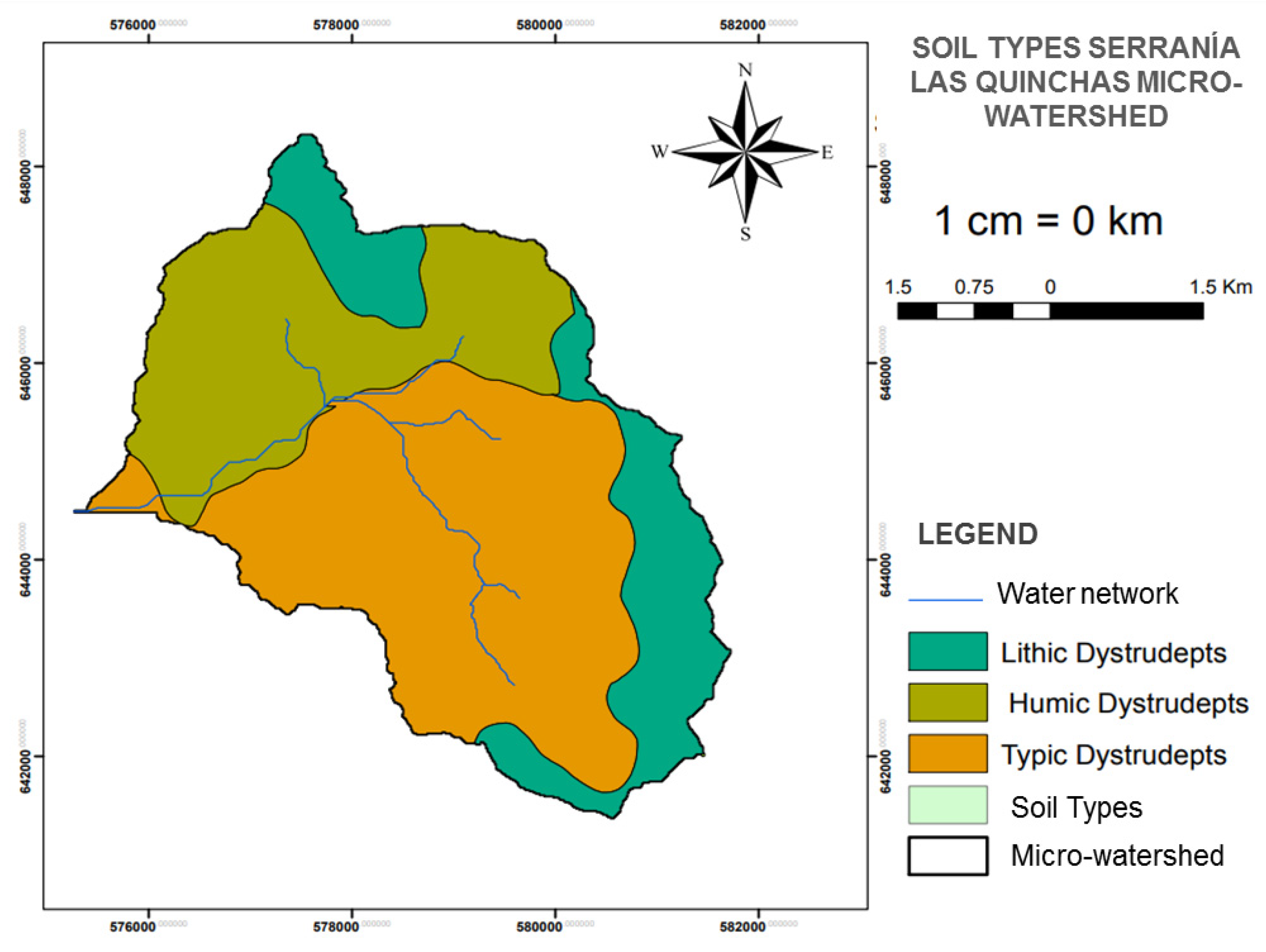
| UCS | UCS_F | Soil Type (Component) | Landscape | Relief Type | Lithology | Characteristics | Profile | Percentages | Weather |
|---|---|---|---|---|---|---|---|---|---|
| MVA | MVAfp | Lithic Dystrudepts | Erosional structural mountains | Homoclinal beams and ridges | Clayey silt clastic sedimentary rocks | Moderate to strongly broken relief, with slopes between 12 and 50%, affected by diffuse runoff to a slight degree and stoniness; deep, imperfect to well-drained soils, with clayey textures, light, and highly acidic saturated reaction. | PJ-4; PJ-5; PJ-97 | 35, 30, 25 | Warm, humid |
| MPA | MPAf1 | Humic Dystrudepts | Erosional structural mountains | Homoclinal beams and ridges | Classical mixed sedimentary rocks | Moderately steep relief, with slopes of 50–75%, affected by mass movements (solifluction), landslides, reptation and diffuse runoff to a slight degree and stoniness; superficial soils, limited by aluminum saturation. | PB-27A; PJ-100; PJ-18 | 40, 30, 30 | Medium, very humid |
| MVA | MVAf1 | Typic Dystrudepts | Erosional structural mountains | Homoclinal beams and crests | Clayey silt clastic sedimentary rocks | Moderate to strongly broken relief, with slopes between 12 and 50%, affected by light diffuse runoff and stoniness; deep soils, imperfect to well-drained, with clayey textures, light and extremely acid reaction, saturated. | PJ-4; PJ-5; PJ-97 | 35, 30, 25 | Warm, humid |
| Profile | SNAM (Soil Name) | NLAYERS | HYDGRP (Hydrological Group) | SOL_ZMX (Maximum Rooting Depth mm) | ANION_EXCL (FRACTION of Porosity Where Anions Are Excluded) | SOL_CRK (Maximum Volume of Soil Profile Rupture m3/m3) | TEXTURE (Texture of the Soil Layer) | SOL_Z (Depth mm) | SOL_BD (Apparent Density g/cm3) | SOL_AWC (Soil Water Availability mm/mm) | SOL_K (Hydraulic Conductivity mm/h) | SOL_CBN (Organic Carbon %) | Organic Matter (%) | CLAY (% Clay) | SILT (% Silt) | SAND (% Sand) | ROCK (% Rock) | SOL_ALB (Soil Albedo) | USÑE_K (Soil Aerodynamics K-Factor) |
|---|---|---|---|---|---|---|---|---|---|---|---|---|---|---|---|---|---|---|---|
| PJ-5 | Lithic Dystrudepts | 1 | C | 15 | 0.5 | 0.5 | Fr.A | 150 | 1.48 | 0.14 | 2.31 | 0.21 | 0.36 | 34 | 39 | 27 | 0 | 0.520 | 0.167 |
| PJ-83 | Humic Dystrudepts | 2 | C | 27 | 0.5 | 0.5 | Fr | 920 | 1.20 | 0.17 | 19.09 | 3.1 | 5.32 | 26 | 46 | 28 | 0 | 0.071 | 0.169 |
| C | 0.5 | 0.5 | Fr.a | 920 | 1.36 | 0.15 | 4.30 | 1.4 | 2.47 | 36 | 40 | 24 | 0 | 0.223 | 0.176 | ||||
| B-14 | Typic Dystrudepts | 2 | C | 30 | 0.5 | 0.5 | Fr.a.A | 400 | 1.10 | 0.16 | 19.64 | 4.5 | 7.79 | 33 | 42 | 25 | 0 | 0.027 | 0.168 |
| C | 0.5 | 0.5 | Fr.a | 1100 | 1.36 | 0.15 | 4.30 | 1.4 | 2.47 | 36 | 40 | 24 | 0 | 0.223 | 0.168 |
| ID | Coverage Type | Code (SWAT) | Area (Ha) | Percentage (%) |
|---|---|---|---|---|
| 0 | Forest-mixed | FOREST | 1385.2 | 58.5 |
| 1 | Mosaic of pastures with natural spaces | FRSD | 349.4 | 14.8 |
| 2 | Pasture and crop mosaic | RYEG | 130.6 | 5.5 |
| 3 | Rivers | WATR | 14.6 | 0.6 |
| 4 | Grassland | BROM | 77.9 | 3.3 |
| 5 | Secondary vegetation | RNGE | 407.9 | 17.2 |
| Type of Coverage Corine Land Cover Classification | Description | SWAT Code |
|---|---|---|
| Forest-mixed | Cover consisting of a vegetation community dominated by typical, regularly distributed arboreal elements, which form a discontinuous canopy layer, with a canopy height greater than 5 m and whose tree cover area represents between 30% and 70% of the total area of the unit. These vegetation formations have not been intervened, or their selective intervention has not altered their original structure and functional characteristics. Therefore, fragmented forests are excluded from this unit and are classified in the respective unit [41]. | FOREST |
| Mosaic of pastures with natural spaces | It comprises areas with pastures in combination with natural spaces; the pastures have an area of less than 25 ha, being 30 to 70% of the total area. The natural spaces are made up of natural forest, shrublands, gallery or riparian forest, swamps, and other areas that have not been intervened or little transformed [41]. | FRSD |
| Pasture and crop mosaic | These are lands with pastures and crops, with a plot size of less than 25 ha; the distribution is very dispersed, so they cannot be represented individually [41]. | RYEG |
| Rivers | Refers to rivers with a channel width greater than or equal to 50 m [41]. | WATR |
| Grassland | It is made up of herbaceous vegetation zones, developed naturally, forming a dense cover (>70% occupancy) or open (30 to 70% occupancy). These are vegetation formations without intervention [41]. | BROM |
| Secondary vegetation | They are mainly shrub and herbaceous vegetation with an irregular canopy, sometimes with trees and creepers, the initial vegetation succession after deforestation or afforestation of pastures [41]. | RNGE |
| Slope Range Used for the Model | IGAC Slope Range (%) | Relief |
|---|---|---|
| Class I (0–7%) | 0–3% | Flat, flat-concave topography. |
| 3–7% | Slightly sloping and slightly undulating topography. | |
| Class II (7–25%) | 7–12% | Moderately sloping, slightly broken, and moderately undulating topography. |
| 12–25% | Steeply sloping, moderately broken, and strongly undulating topography. | |
| Class III (25–50%) | 25–50% | Topography slightly steep, strongly broken, and slightly steep. |
| Class IV (50–75%) | 50–75% | Moderately steep and moderately rugged topography. |
| Class V (75–99%) | >75% | Very steep and rugged topography. |
Publisher’s Note: MDPI stays neutral with regard to jurisdictional claims in published maps and institutional affiliations. |
© 2022 by the authors. Licensee MDPI, Basel, Switzerland. This article is an open access article distributed under the terms and conditions of the Creative Commons Attribution (CC BY) license (https://creativecommons.org/licenses/by/4.0/).
Share and Cite
Ortegón, Y.A.C.; Acosta-Prado, J.C.; Acosta Castellanos, P.M. Impact of Land Cover Changes on the Availability of Water Resources in the Regional Natural Park Serranía de Las Quinchas. Sustainability 2022, 14, 3237. https://doi.org/10.3390/su14063237
Ortegón YAC, Acosta-Prado JC, Acosta Castellanos PM. Impact of Land Cover Changes on the Availability of Water Resources in the Regional Natural Park Serranía de Las Quinchas. Sustainability. 2022; 14(6):3237. https://doi.org/10.3390/su14063237
Chicago/Turabian StyleOrtegón, Yuddy Alejandra Castro, Julio César Acosta-Prado, and Pedro Mauricio Acosta Castellanos. 2022. "Impact of Land Cover Changes on the Availability of Water Resources in the Regional Natural Park Serranía de Las Quinchas" Sustainability 14, no. 6: 3237. https://doi.org/10.3390/su14063237
APA StyleOrtegón, Y. A. C., Acosta-Prado, J. C., & Acosta Castellanos, P. M. (2022). Impact of Land Cover Changes on the Availability of Water Resources in the Regional Natural Park Serranía de Las Quinchas. Sustainability, 14(6), 3237. https://doi.org/10.3390/su14063237