Article

Using Soil Sustainability and Resilience Concepts to Support Future Land Management Practice: A Case Study of Mt Grand Station, Hāwea, New Zealand

1
Faculty of Agriculture and Life Sciences, Lincoln University, Lincoln 7647, Canterbury, New Zealand
2
Scion, Rotorua 3010, North Island, New Zealand
3
Faculty of Environment, Society and Design, Lincoln University, Lincoln 7647, Canterbury, New Zealand
*
Author to whom correspondence should be addressed.
Sustainability 2022, 14(3), 1808; https://doi.org/10.3390/su14031808
Submission received: 29 December 2021 / Revised: 24 January 2022 / Accepted: 29 January 2022 / Published: 5 February 2022

Abstract

:
Soil acts as the integrator of processes operating within the biological and hydrological landscapes and responds to external disturbances and processes on varying time scales. The impact of any change results in a corresponding response in the system; which is dependent on the resistance of the soil system to the disturbance. Irreversible permanent change results when the soil system shifts over a threshold tipping point; with the soil system experiencing a regime shift with associated structural and functional collapse. Climate change is the most important external disturbance or stressor on these systems due to changes in precipitation, temperature and moisture regimes. Our research at Mt Grand is focused on approaches to increasing land use resiliency in the face of environmental change. Our purpose is to select and apply soil quality indices which can be used to assess soil resilience to external disturbance events for Mt Grand Station in New Zealand. We will identify biophysical variations and landscape drivers in soil resilience; and use these results to match land management practices with variations in soil resilience. For example, soils with low resilience will only have land management practices that have a low impact on the soil resource. We selected soil attributes that represented indicators of resistance, used to quantify the capacity of a soil to recover its functionality. We mapped this soil resilience framework against a national database of soil and landscape attributes for Mt Grand Station. The output from this research is to posit a conceptual framework of soil quality indices which relates to soil resilience, and thus to create a spatial map of soil resilience for Mt Grand Station.

1. Introduction

While pastoralism provides food, fibre and economic return, it can also transform landscapes by wide ranging impacts—ranging from ecosystem biodiversity, changes in water quantity and quality and soil erosion. Understanding ecosystem change in response to these grazing impacts is vital to contribute to a wider discourse on how future pastoral production systems can be truly sustainable.
Soil ecosystem services underpin much of the functionality and productivity of the terrestrial landscape; the biodiversity of the soil flora and fauna, and the pasture impact of the grazing herbivores. The ability of the soil to recover from external stressors such as climate change, will allow soils to be a major part of a more resilient ecosystem, and hence provide the basis for a more sustainable, multifunctional pastoral system.
Soils exist at the interface of the biosphere, hydrosphere, lithosphere and atmosphere. They act to integrate the processes operating within these spheres by responding to external disturbances and processes on varying spatial and temporal scales. Change in a biophysical system is the result of movement over a threshold tipping point. The impact of any change is manifested by the response of the system, and this in turn is dependent on the resistance of the soil system to the disturbance. Climate change represents the external stressor with the potential to have a significant impact on terrestrial ecosystems and affect soil functions directly and indirectly [1,2,3,4]. Direct impacts include changes in precipitation, temperature and moisture regime, while indirect effects include adaptions in irrigation, tillage, crop and stock rotation management practices, and soil erosion [1,2,3,4]. The consequences of global climatic change are likely to be associated with changes in land use and land management. The IPCC Special Report on Climate Change and Land [5] addresses how a changing climate will increasingly affect how we use the land. On a holistic human ecosystem scale, soil represents the nexus of water, energy and food. If we rely on the soil (and therefore land) for food, energy, water, health and well-being, impacts of climate change will exacerbate any pressures of current land management practices.
Soil resilience is the “Capacity of the soil to recover its functional and structural integrity after a disturbance; where this integrity can be considered as soils capacity to perform essential soil functions” [6]. Ludwig et al. [7] noted that the ability to maintain the efficiency of function and the existence of that function could be taken as a measure of soil management sustainability. Thus we take soil sustainability in this context to be the maintenance of soil functional integrity. By this definition, it is multifunctional—being the “sum of the processes that sustain the soil system” [7]. From this we interpret that multiple factors define soil functional integrity.
The soils capacity to recover will thus be a function of the rate of recovery (time required) and degree (magnitude) of recovery. Disturbance events are those that result in a significant change in the ecosystem functioning, deviating from the normal pattern [8]. For agricultural systems, disturbances can be associated with tillage, cultivation, compaction, addition of fertilisers, monoculture resulting in exclusion of specific competing plant species [9]. On a global scale, disturbance events associated with climate change will result in drought-related impacts. Associated with soil resilience is the allied concept of soil resistance. This is the capacity of a soil to continue to function without change throughout a disturbance [10]. This can be further applied to the concept of sustainability: whereby soil resistance is the magnitude of the decline in the capacity of the soil to function and resilience is the rate of recovery [11,12].
The concepts of resilience, resistance and sustainability relate to soil quality. Soil quality can be defined as “the capacity of a specific kind of soil to function, within natural or managed ecosystem boundaries, to sustain plant and animal productivity, maintain or enhance water or air quality, and support human health and habitation” [6,13]. The attributes of a soil that define quality can be considered as the inherent properties as defined by the five factors of soil formation [14]. They can also be dynamic properties—a change in the soil function as influenced by human use and management of the soil. This soil functionality can be measured by reference to a baseline condition [15].
If resilience is the capacity to recover following an external disturbance, then resilience is actually a dynamic property. We can monitor the rate of recovery following such a disturbance event, but the recovery phase may be long-term and may not have baseline data available preceding the disturbance event [12]. The ability to measure disturbance mechanisms will also depend on the kinetics of the mechanisms. If the soil has high resilience, it is likely that the mechanisms can be measured; but if the soil has low resilience, the threshold (resulting in change to the system) has been crossed, and the soil has moved into a lower functional capacity [12]. An approach that has had some success is to measure indicators of resistance, which will quantify the capacity of a soil to recover its functionality. Selection of appropriate indicators is dependent on how it responds to a disturbance event. Potential indicators include many dynamic soil properties, including soil chemical (CEC, pH, SOM, exchangeable cations), biological (microbial activity, soil biodiversity) and physical (structure, soil water, microaggregates and stability, water retention and transmission) [9].
Orwin and Wardle [16] measured a series of biological indicators. They quantified the soil response to a number of experimental conditions, using wet-dry cycles and the effect on soil microbial biomass. They based their index of resistance on a measured difference between the control soil and the disturbed soil at the end of the disturbance. They noted that in order to compare the stability of different systems, its necessary to use indices that are a relative quantitative measure of both the resistance and resilience of a response variable. Increasingly, there has been a growing awareness that soil biological and microbial diversity is a vital component of soil functionality, and hence soil quality. The health of the biological component of the soil is crucial for soil resilience. Lehman et al. [17] posit that “soil health and resilience will rely on maintaining functionally diverse, robust soil biological communities that support high levels of critical services, simply by carrying out their life-sustaining processes.”
De Vreis et al. [18] examined the importance of soil biota and of their role in C and N cycling and resilience and resistance to external drivers like climate change. They showed that land use alters the stability of soil food webs, together with the ecosystem services they provide under conditions of an external disturbance event such as climate change. A fungal based food web (together with the C and N processes of loss it governs) in a grassland soil system was more resistant, but not resilient, and better able to adapt to drought, compared to the bacterial-based food web associated with a wheat soil system. They concluded that land use practices will strongly affect the resistance and resilience of food webs to climate change. Importantly, the resistance of the grassland food web was increased after the drought external disturbance, which may suggest that it can adapt to a changing climate.
When considering the wider positioning of soils in multifunctional pastoral systems, there is the need to consider the human, social and cultural dimensions, not just with respect to crop yield and food nutrition, but also with improving people’s connection to the soil resource [19]. Soil health builds on the concept of soil quality. Doran [13] frames it as “the continued capacity of a soil to function within ecosystem and land-use boundaries to sustain biological production, maintain environmental quality, and promote plant and animal health”. It portrays soil as a living, dynamic system whose functions are mediated by a diversity of living organisms that require management and conservation.
Soil quality is inherently complex, since it can be viewed through the agri-systems productivity lens and also the lens of natural ecosystems, where the emphasis is on maintaining environmental quality and the conservation of biodiversity [20]. Kibblewhite [21] reflects on soil health as a “fitness for agricultural production” perspective, whereby assessment is based on this end goal—measurement of agricultural yields and soil properties that control these particular outputs. While Bunemann [20] considers soil health and soil quality to be equivalent.
In New Zealand, soil health is predominantly viewed through the lens of crop yield and food nutrition, and emphasizes biophysical parameters over social dimensions. However, there is uncertainty around which biophysical indicators to use to support land management decisions. Baveye et al. [22] contend that we simply do not fully understand the complex interrelationships between all the soil components that influence soil functionality. Booth et al. [23] posit that because of this uncertainty, a more holistic approach, encompassing indigenous knowledge including Mātauraka Māori will allow us to address the question of how to increase the productivity of and improve the sustainability of soils [24]. There are a number of approaches to selecting attributes of soil to quantify soil resilience. Both Karlen et al. [6] and Ludwig et al. [7] note that soils have different components of resilience. At a deeper level, resilience is a function of both functional integrity and structural integrity. Structural integrity is based on intrinsic physical factors of the soil and the associated landscape. These parameters such as profile available water, and potential rooting depth are unlikely to change on a land management time scale. Biophysical factors such as slope angle and altitude are also important here, and again, are unlikely to change on similar land management timescales. Functional integrity is a more dynamic concept, comprising chemical and some physical parameters. These include soil pH, CEC, % carbon and P retention, conductivity, salinity. These parameters are more susceptible to change as a result of land management practices. Moreover, these soil attributes relate to the intrinsic properties of soils and landscapes themselves.
It follows therefore that there is a considerable range of soil properties that relate to determining soil quality, and that these change on varying temporal and spatial scales. Defining baseline values will allow an assessment of change in response to changes in land management practice. It is vital therefore that the selected attributes are sensitive enough to reflect the capacity of the soil to function as a biological entity, and can also indicate soil quality. Soil systems include both attributes that are inherently static (parent material, slope angle) and dynamic attributes which respond to management (pH, total C, Total N, stoniness) [25].
Resistant soil systems do not undergo change in response to external disturbances. Resilient soil systems demonstrate reversible, temporary change, but no change in functionality. However, irreversible permanent change results when the soil system shifts over a threshold tipping point; with the soil system experiencing a regime shift with associated structural and functional collapse. Ludwig et al. [7] encapsulated this concept of system responses to change by defining three levels of disturbance, and the associated system change (Table 1).
As soil is a multifunctional entity, it follows that a range of parameters or attributes that mirror the physical, chemical and biological components of the soil landscape nexus are used. These are already quantified in New Zealand within different databases, such as the New Zealand Land Resource Inventory (NZLRI) [26] and National Soil Database (NSD). In New Zealand, SINDI (Soil INDIcators) is a web-based tool designed to help interpret the soil health or soil quality of a sampled soil, by comparison to the NSD or soil quality dataset (www.sindi.landcareresearch.co.nz (accessed on 9 August 2021)). It also utilises the online database soils map for New Zealand. However, these indicators do not measure soil quality, per se, instead they measure attributes of a soil. For New Zealand, a minimum data set of 7 indicators were selected (Olsen P, pH, anaerobically mineralisable N, total C, total N, bulk density, macroporosity). From this minimum data set, principle components analysis identified 4 primary factors that describe the soil quality. These are: Olsen P (fertility status); pH (acidity status); anaerobic N, total N, total C (soil organic resources); and bulk density, macroporosity (physical status of the soil) [27].
While soil quality indices (SQI’s) have often been employed with regard to agricultural land use applications [28,29], they have been less so applied with regard to specific soil threats, soil functions and ecosystem services [20]. Moreover, these researchers note the value of also considering these latter indicators, as these are of vital importance to both land managers and policy makers. In the context of the wider research that is been carried out as part of the Centre of Excellence at Lincoln University (Designing Future Productive Landscapes), is the concept that soil quality raises the awareness of and enhances communication between stakeholders as to the importance of the soil as a resource [19,24].
The research we report here is part of a larger body of work revolving around designing future productive landscapes and productive agri-systems in order to investigate how to maximize viability of high-country farm production and service systems. Our wider research is endeavouring to identify production systems and services that Mt. Grand Station is capable of and able to sustainably support. At Mt Grand Station, there is spatial variability in biophysical factors such as aspect, climate, geology, soils and biodiversity. This biophysical landscape in turn is overlain by a managed landscape with differing pasture species, animal stock, soil nutrient management and ecological management.
We are seeking to understand how variations in soil resilience can assist land users to improve their land use and management decisions in support of current and future adaptation to environmental change driven by external stresses, such as climate change. This information will further our understanding of how to increase land use resiliency in the face of environmental change through improved matching of natural soil resilience with appropriate land use management. This research is especially relevant, given the economic, social and environmental impact that future climate change scenarios predict for pastoral ecosystems. As a first step, we will select and apply soil quality indices which can be used to assess soil resilience to external disturbance events for Mt Grand Station in New Zealand. The aim of the research reported here is to posit a conceptual framework of soil quality indices which relate to soil resilience; to create a spatial map of soil resilience for Mt Grand Station. The second stage of the research (not reported here) will be to apply models of future climate scenarios and compare to the soil resilience map.

2. Materials and Methods

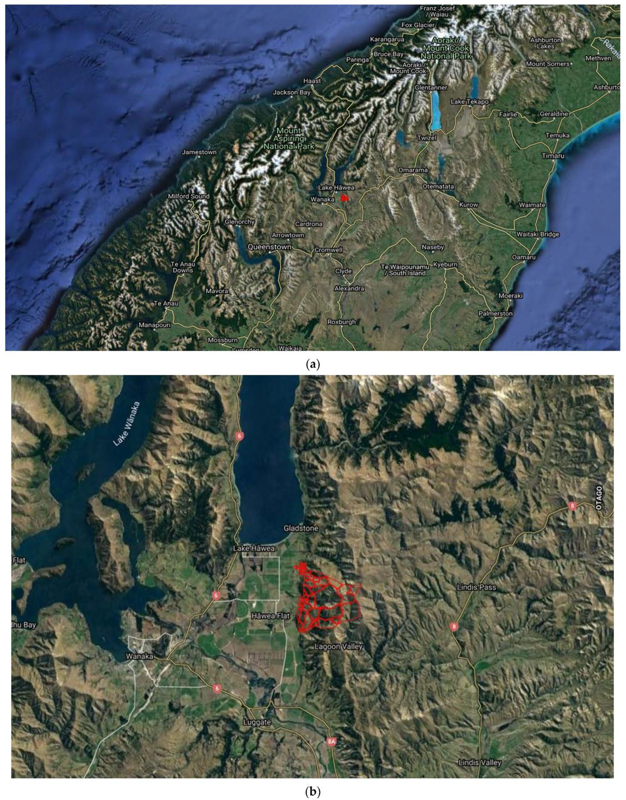
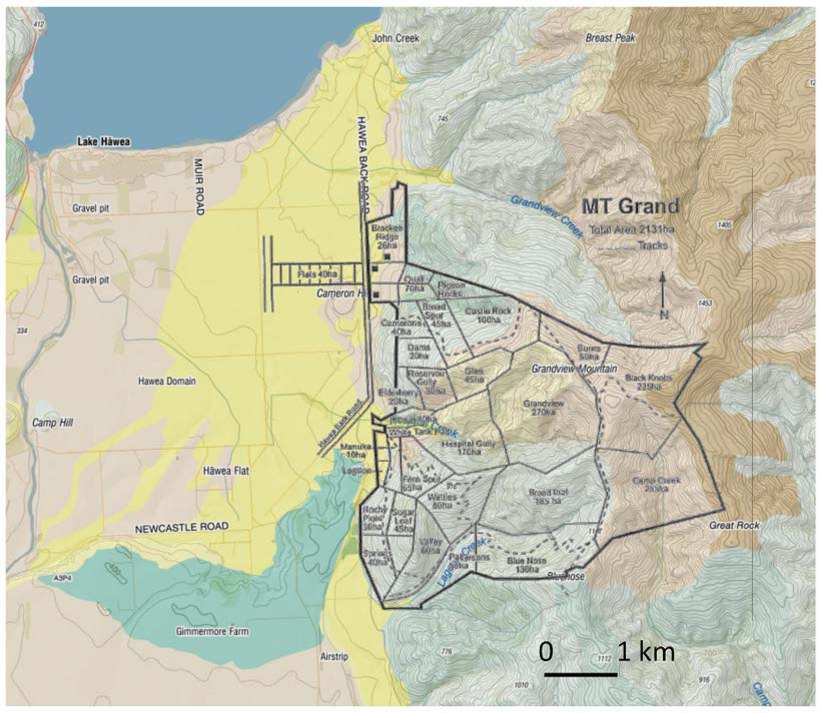
2.1. Location and Geology

Mt. Grand station is located close to Lake Hāwea, Central Otago. (Figure 1a,b). The geology of Mt Grand station is dominated by basement rock of Rakaia Terrane, comprising Haast schist (consisting of schistose to non-schistose greywacke; well foliated, slightly segregated schist). The wider topography of the area consists of fault bounded intermontane basins containing Cenozoic sediments, bounded by uplifted mountain ranges of Rakaia Terrane. The Haast schist can be seen on Mt Grand station as exposed bedrock and rocky peaks. Following separation of the New Zealand subcontinent (Zealandia), from Gondwana approximately 80 Ma, the Haast schist was progressively eroded during the late Cretaceous to early Miocene to form the time-transgressive, Waipunamu erosion surface. This wave-cut, planar surface was subsequently overlain by Cenozoic sediments of marine and terrestrial origin and subsequently uplifted during the Kaikōura Orogeny [30].
During the Pleistocene, the Upper Clutha Valley area was extensively glaciated, with glaciers flowing in a north to north-west direction along valleys now occupied by the present day Lake Wanaka and Lake Hāwea. The oldest glacial deposits date to Q14–16 (approximately 620–660 ka). The southern extent of Lake Hāwea is bounded by hummocky moraine, dating to Q2. Holocene colluvial and alluvial fans (Q1) are present along the margins of the intermontane basins [31].

2.2. Soils

The soils in the intermontane basins are dominated by glacial sediment parent materials comprising moraines and outwash gravels. Adjacent to the uplifted basement Haast schist, soils are developed on Holocene colluvial and alluvial fans, terraces and floodplains. On the steeper slopes at higher elevation, soils are developed on the Haast schist. In places, loess provides cover to varying depths over the schist [32,33]. On steeper slopes, the Haast schist bedrock is exposed.
Soils in this area have been mapped during the South Island 4 mile survey [33] and the Upper Clutha survey [32]. Soil information for Mt Grand was derived from S-map and the National Soil Database. The soils were classified using the NZ soil classification [34]. The upland slopes developed on the schist bedrock comprises orthic Brown and acid Brown soils. Where loess covers the schist, immature Pallic and argillic Pallic soils occur. On shallow and close to exposed bedrock at high elevation, rocky Raw soils occur (Figure 2). There are small areas of soils developed on colluvial fan material at lower elevations. There is a strong relationship between the soil and landscape, which is summarised in Table 2.
S-Map is Manaaki Whenua Landcare Research’s ongoing project to map New Zealand’s soil resources at a nominal 1:50,000 scale. As of August 2021, S-Map coverage stood at 37.1% of New Zealand. More than two-thirds (67.7%) of New Zealand’s multiple use land (LUC 1–4: horticulture, cropping, and intensive pasture systems) has been covered by S-Map, but less than a quarter for the other land use classes (LUC 5–8: extensive pasture/forestry and conservation) have been covered. Coverage varies greatly between regions, reflecting the availability of legacy surveys at an appropriate scale and the degree of investment by different regional councils in soil mapping. Waikato (72%), Bay of Plenty (59%) and Canterbury (46%) are the regions with highest S-Map coverage. S-Map brings together data from both existing surveys, combined with new surveys. Where soil property information is not directly available, soil properties are inferred, using an inferencing engine. The S-Map project is thus a key component in supporting sustainable development and scientific modelling within New Zealand (https://soils.landcareresearch.co.nz/ (accessed on 9 August 2021)).

2.3. Soil Attributes to Use to Define Soil Resilience and Soil Sustainability

Soil attributes that contribute to soil structural and functional integrity are key to help our understanding and ability to quantify soil resilience in response to disturbance events. In S-map, these attributes include data on the New Zealand Soil Classification (NZSC) Order, Group, Subgroup; parent material; rock class; texture; permeability; depth class; drainage; rooting depth and profile available water. S-map accounts for less than a quarter of the land use classes 5–8 (extensive pasture/forestry and conservation, including hill and high-country areas, such as Mt Grand Station). However, there is a wider spatial coverage of soil attributes in New Zealand, called soil Fundamental Data Layers (FDL). These cover three broad areas as defined in Table 3 and originate from an expert derived joining together of attributes from the NZLRI and the NSD (https://soils.landcareresearch.co.nz/ (accessed on 9 August 2021)). As these FDLs contain spatial information for these 16 key soil attributes, they are measurable and are used in modelling in New Zealand for soil and resource management related research. They are a nationally recognized and accepted grouping of attributes. They were created by the informatics team at Manaaki Whenua Landcare Research, the Crown Research Institute with responsibility for soil resource mapping and related informatics.
In addition to the soil FDL in Table 3, there are other attributes from the NSD that are of value, which we used to derive our soil resilience attributes. These include attributes of the physical landscape derived from the NZLRI and those that contributed to functional integrity and to structural integrity.
We selected the attributes from Table 3, plus altitude, slope and erosion severity class, conductivity, particle size and depth to slowly permeable horizon. For each attribute, we defined according to the classes high (1), medium (2) and low (3) resilience. We used the approach of Webb and Wilson [35] in their evaluation of rural land, to apportion their class rating to our values for the soil attributes. From this, we derived our soil resilience classes: Class 1 (resistant); Class 2 (resilience) and Class 3 (regime shift).
The spatial data of soil and landscape attributes were built using a combination of remote sensing data and on-ground data collection, using ArcGIS/Arcmap 10.7.1 ® software (Esri, Redlands, California, USA). The data collected was RGBN 16 bit (Red, Green, Blue, NIR) multispectral imagery at 12.5 cm ground sampling distance, along with LIDAR to create digital elevation models (DEM) and digital terrain models (DTM). These models allowed us to generate raster layers in Arcmap including for slope, altitude, aspect. [36]. Raster layers were converted to vector files. The attributes of slope, erosion severity and altitude were overlain to indicate soil physical resilience. The attributes of CEC, soil pH, soil C and P retention were overlain to give soil functional integrity. In other words, each attribute was represented by one layer, and maps were overlaid to determine the overall soil resilience class, utilizing the soil resilience variables defined during this research. Data was classified into the resilience classes (1, 2 or 3) in order to standardise the maps to one scale.

3. Results

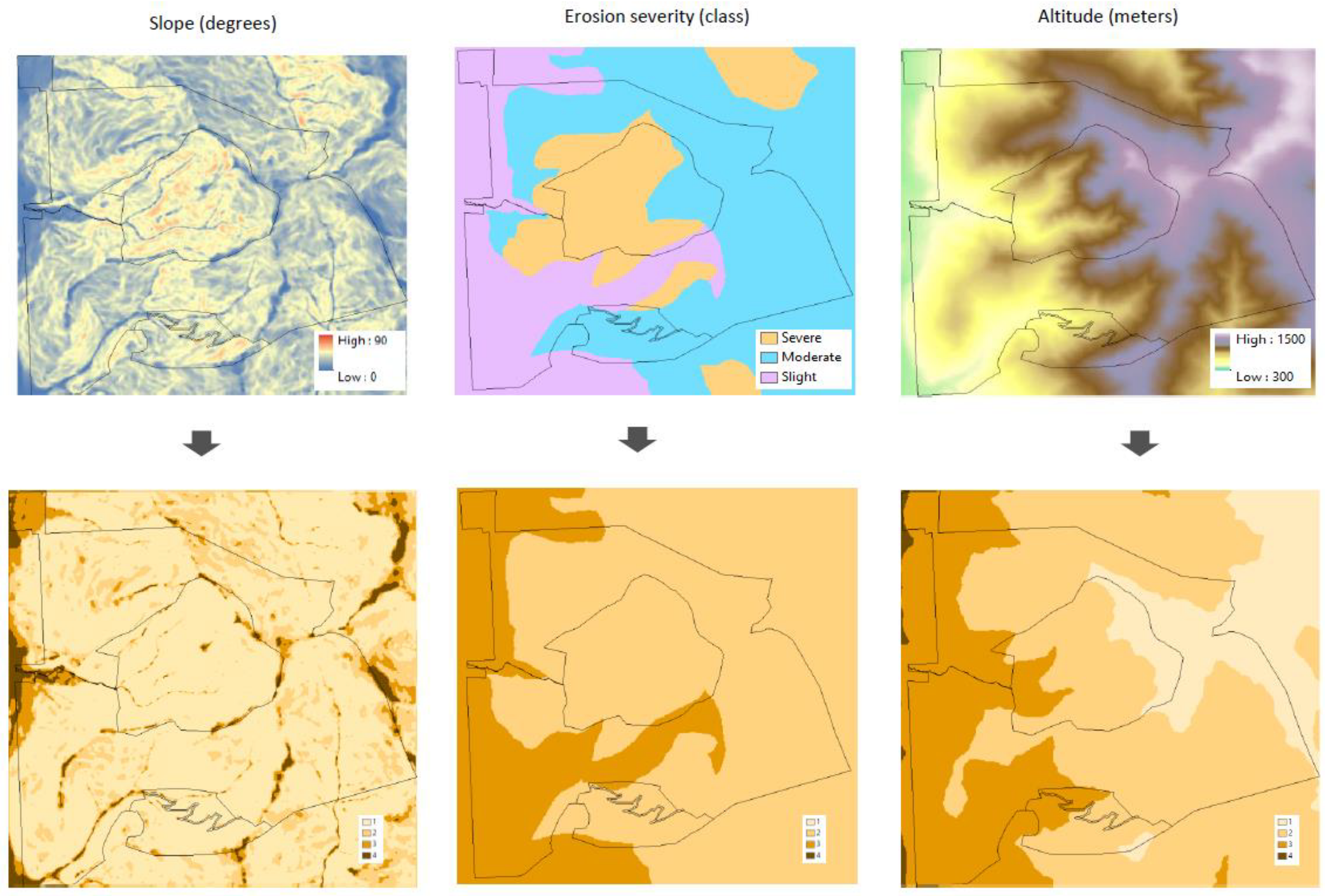
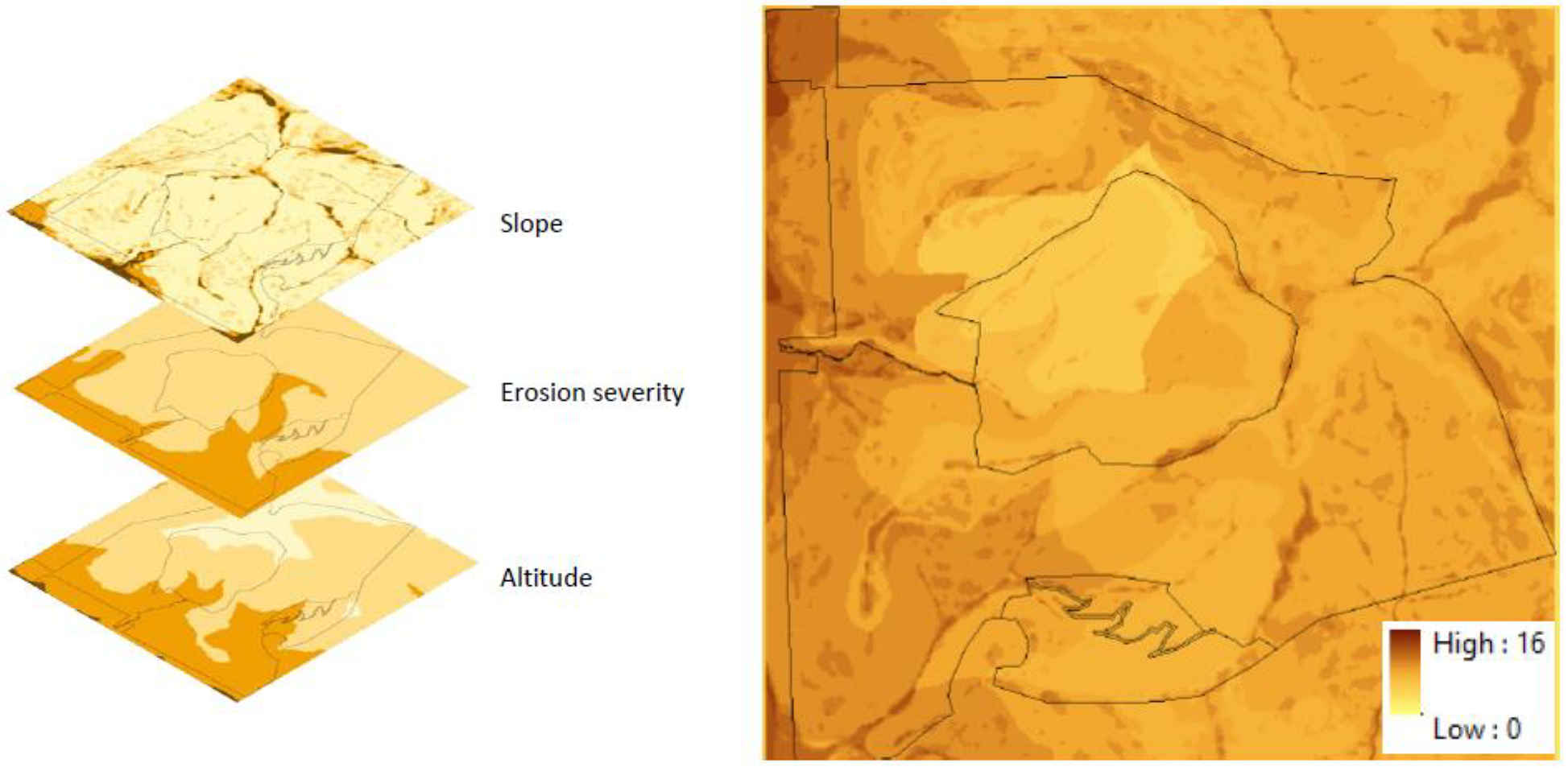
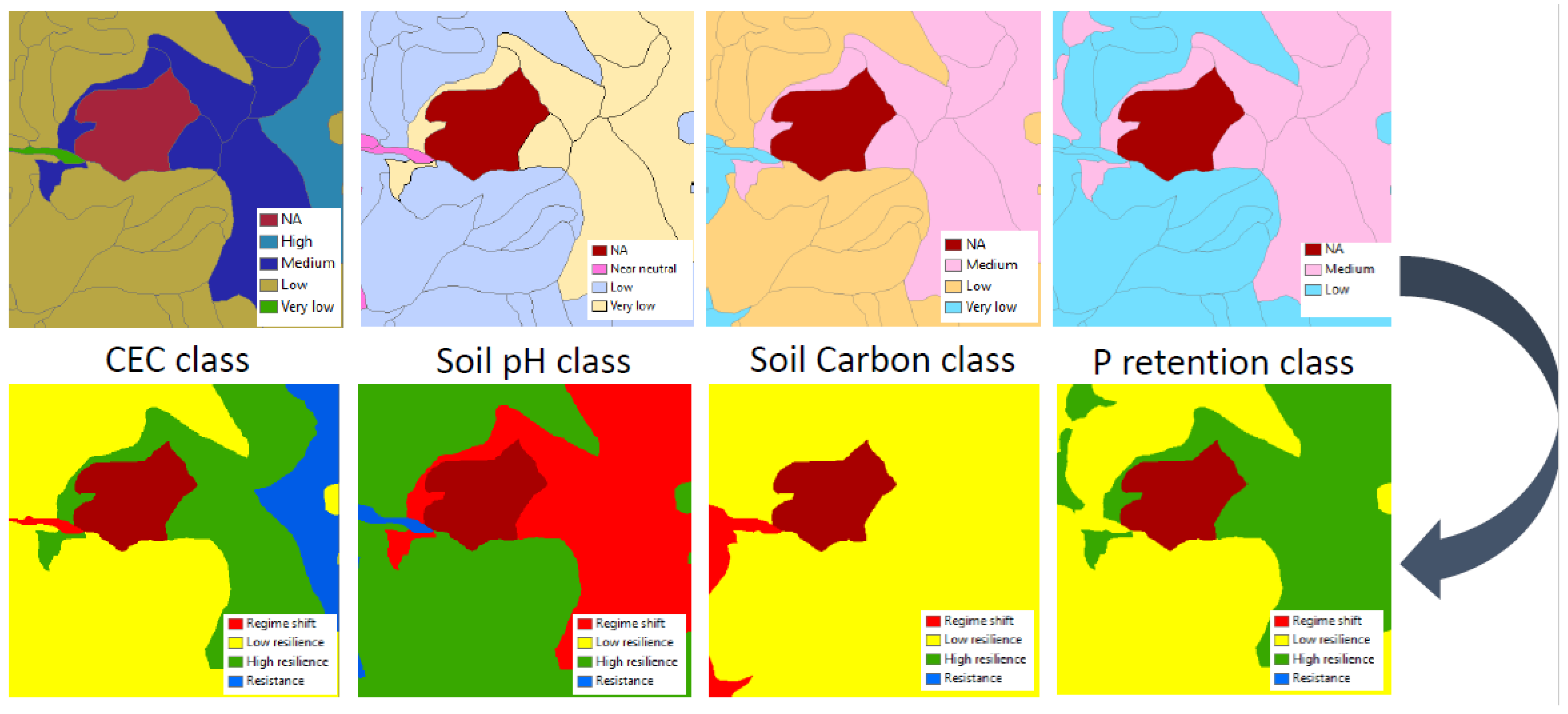
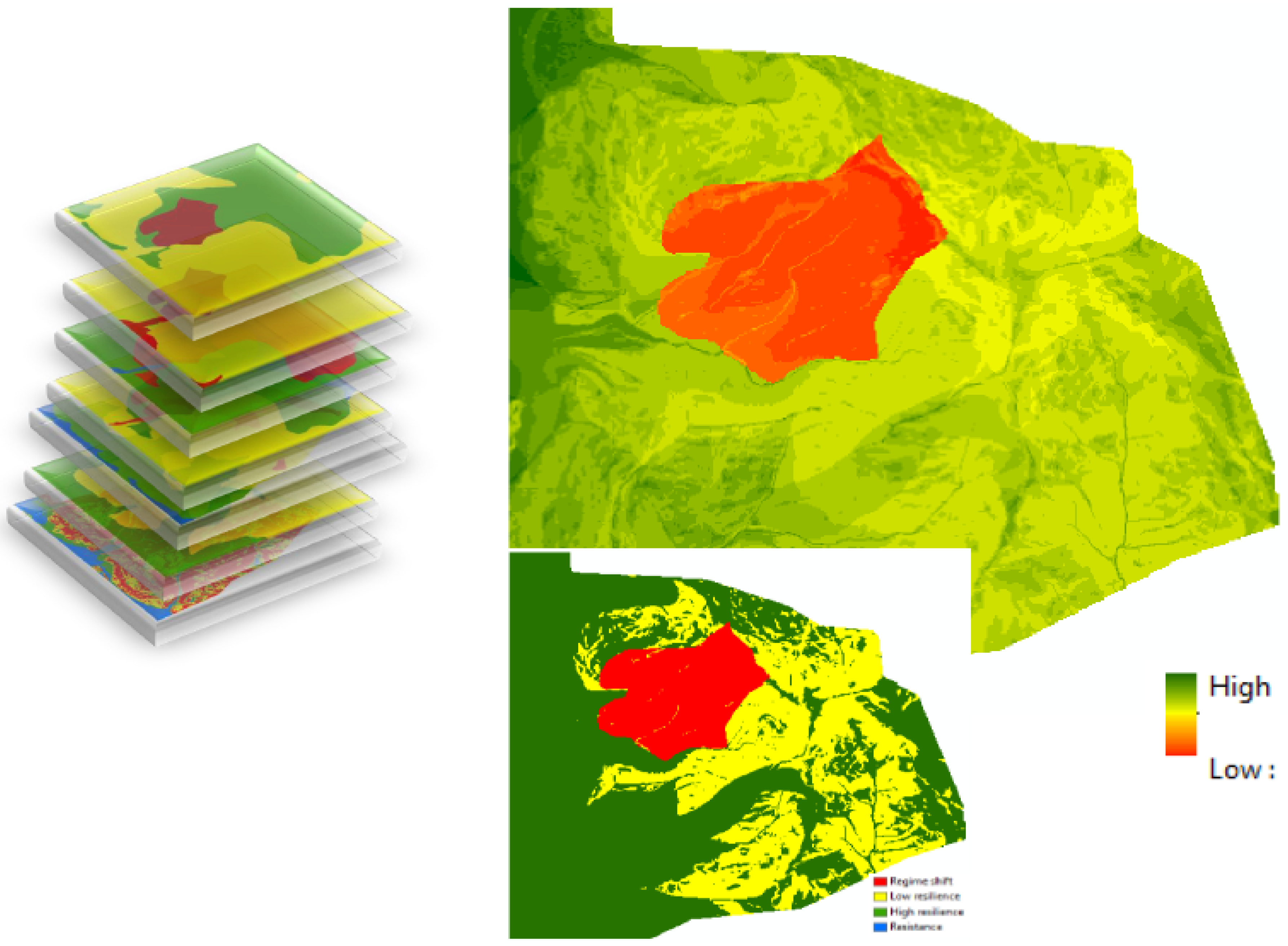
Defining the Soil Resilience Variables and Their Spatial Extent at Mt Grand Station

The soil attributes used to define the soil resilience are presented in Table 4. These are nominally divided into 3 groups, Class 1, Class 2 and Class 3, after Table 1. The physical attributes are landscape components that are fixed and we consider that they do not change with changes in land management practice. Similarly, the structural integrity attributes are also dominantly physical attributes and are also largely fixed in their functionality. However, we have assigned the functional integrity of the soil as being based on chemical attributes which are more dynamic in nature, which can change and be moderated by land management practices, as noted by [20,36]. For example, soil pH can be modified by applications of lime; and carbon% can be increased in soils by specific land management practices resulting in carbon sequestration.
To allocate the values for the attributes in the three classes, we used the framework in Webb and Wilson [36]. For example, if three classes were allocated in [36], then these would equate to soil resilience classes 1, 2 and 3. If five classes were allocated, then the two end members would equate to classes 1 and 3. Moreover with rock outcrops, non-rocky (1) and slightly rocky (2) were allocated to resilience class 1, while moderately rocky (3) was allocated to resilience class 2 and very rocky (4) and extremely rocky (5) were allocated to resilience class 3 (Table 4). These class allocations can be modified with field based data if available; and this would be the next step in testing the soil resilience class model presented here. This future testing will include overlaying resilience classes with projected changes in rainfall intensity and frequency, incidence of drought conditions for extended durations and changes in seasonal temperature changes with longer extents at high and low temperatures.
Figure 3 and Figure 4 show the vector files from Arcmap for the physical resilience attributes of the soil. To determine the resilience class, we used the parameter ranges from Table 4. In initial calculations, we divided the resilience class into high and low resilience, to give 4 classes. After consideration of the complexity of data in the vector files, we revised this classification to settle on three classes only: Class 1—resistance; Class 2—resilience; and class 3—regime shift. This is in agreement with the classes in Table 1, and as used by Bünemann et al. [20].
The process was repeated for vector files encompassing the soil functional integrity parameters (Figure 5). Finally, all the vector files of resilience classes were overlaid to generate the overall soil resilience class (Figure 6).
For the final map (Figure 7) low resilience (yellow) and high resilience (green) classes were amalgamated to create class 2, resilience. The allocation of values to the attributes in the three resilience classes in this desk top exercise was on a case-by-case basis, using the values for classes in [35,37] (Table 4). For the purposes of this exercise, class allocation was set at a high level and based on conservative estimates, and applying expert knowledge of soil response to external disturbances.
We took as our external disturbance, climate change. Effects of climate change includes increases in temperature and extreme weather events such as increases in rainfall volume, frosts, storms, droughts. This will also impact on soil erosion, soil compaction, reduction in agricultural productivity and ultimately impact on the sustainability of land use enterprises [38].
Climate change will have both direct impacts on soil functionality (including change in soil C transformations and nutrient cycling) and on soil erosion with increases in frequency and magnitude of storm events [4,39]. For Mt Grand, thin skeletal soils on rocky, steep angled slopes at high elevation subject to more frequent, high intensity rainfall events will have low resilience to soil erosion. Indirect effects will include climate change instigating changes in land management; ranging from change in irrigation, crop and stock rotation to tillage/pasture grazing management [4]. On Mt Grand’s steep and remote land, irrigation in response to extensive dry and possibly drought conditions is not a management option. Instead, it is likely that changes related to pasture vegetation management and stock grazing would be an outcome of adaption to climate change.
When we compared the soil resilience map with the soil map (Figure 7), the class distribution shows that the most resistant soils (Class 1) were largely associated with the fluvial Recent soils on the lower elevation fans. Class 2 soils are resilient to disturbance, and coincided with the orthic Brown soils to the west of the station, and some immature Pallic soils in the north east of the station. Class 3 soils that indicate a regime shift coincided with the argillic Pallic and immature Pallic soils in the south and north of the station. While Pallic soils are versatile soils on flat and gently sloping land; on Mt Grand they are located on steep slopes [39]. It is likely that the associated physical attributes of steep slopes and thin soil depth have allocated these Pallic soils into Class 3.

4. Discussion

4.1. Bioindicators for Soil Quality

Many studies of soil quality focus on defining a minimum data set of soil attributes. Some studies have attempted to derive a single soil quality index, often requiring an element of weighting to convey relative importance of attributes for a given location and context [40,41,42,43]. Our desktop approach was a starting point to evaluate the soil response to external drivers of disruption in order to define an initial broad range of attributes. This was to capture the wide scope of attributes that would contribute to soil resilience and which integrates the soil-landscape system.
These include attributes relevant to both agri-systems productivity and natural ecosystems to maintain environmental quality and biodiversity. In addition, these attributes are present in a New Zealand wide database, as well as covering the Mt Grand study site. By including the biophysical aspects of the landscape (altitude, slope angle etc.)—that is the inherent (static) attributes and the manageable (dynamic) attributes—then the broad scope of contributors to soil quality can be included.
However, there are several approaches to grouping the attributes. We first allocated the factors that drive soil resilience into chemical, physical, biological and landscape groupings, based on their impact on soil resilience. This included the physical landscape group which covered altitude, slope angle and erosion severity. Secondly, a group that covered the integrity of the soil from an ability to maintain functionality (soil pH, CEC total C etc.); these are the dynamic attributes that are more likely to be altered as a result of land management practices. The third grouping includes those attributes that allow the soil to maintain an element of structural integrity (particle size, potential rooting depth, soil temperature etc.); and this we consider to be close to the inherent (static) attributes of Schwilch et al. [25], where these attributes are not prone to change as a result of land management practices.

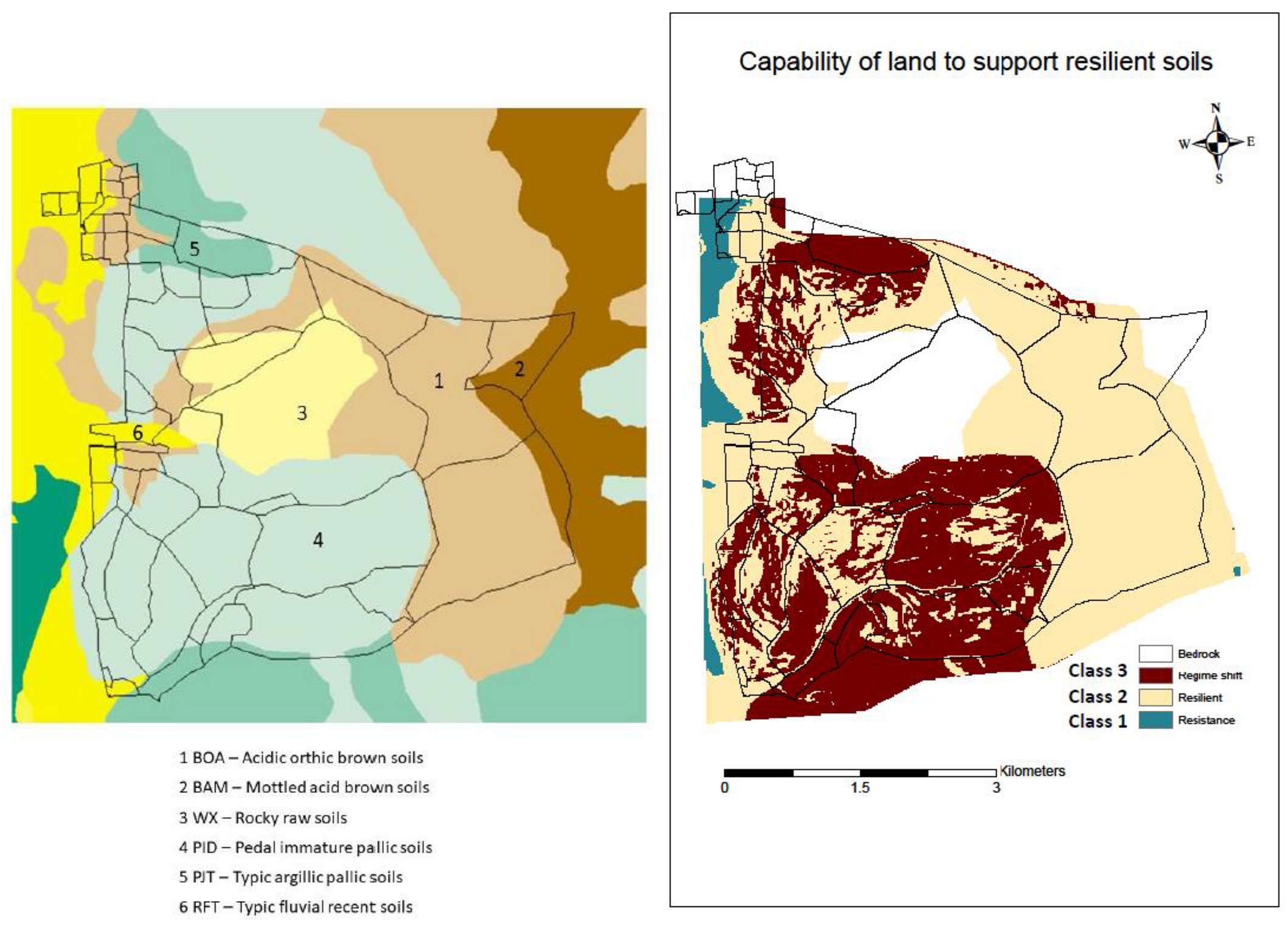
4.2. Allocated Class and Association with Soil Type

In this part of Otago, there is a noticeable relationship between soil type, slope aspect and altitude. Brown soils occur at higher altitudes where rainfall is higher and evapotranspiration rates are lower. On lower altitude slopes which are drier, Brown soils give way to Pallic soils [40]. When we compared the spatial distribution of the regime shift class to the incidence of soil type, the regime shift was closely associated with the mapped distribution of Pallic soils, as well as the NZLRI productivity classes of very low and very low to low. Pallic soils are dominantly formed in loess parent material which for this locality is derived from the glacial erosion of the surrounding quartzo-feldspathic schist bedrock.
At Mt. Grand, loess mantles the northern and western flanks of the uplifted schist bedrock. Pallic soils have silt loam textures with weak structure and low porosity. Under pasture conditions, clay accumulates in the B horizon, as demonstrated in the Blackstone soil series (typic argillic Pallic; [34]) which has thin clay coatings lining pores and on ped surfaces. Pallic soils have low concentrations of secondary iron oxides and weakly weathered parent material; consequently, P retention is often low throughout the soil profile. Soil pH is moderate (and slightly acid in the B horizon), carbon content is low and base saturation can be over 50% in B horizons. The silt loam texture of the Pallic soils contribute to the high slaking potential and make these soils prone to erosion. Pallic soils are also subject to a strong annual cycle of summer water deficit and winter wetness. The pedal immature Pallic soils occupy the larger spatial extent of the Pallic soils at Mt Grand. These soils have no fragipan, or clay accumulation and have weakly expressed Pallic soil features [39] (Hewitt et al., 2021). Considered as a whole, these Pallic soils have moderate natural soil fertility, requiring pH and fertiliser management to enable productive pasture for stock. Both the typic argillic Pallic (Blackstone soil series) and pedal immature Pallic (Arrow soil series) are classed as versatile soils on flat to gently sloping terrain due to their deep rooting potential and high water holding capacity in the upper horizons.
However, at Mt Grand the Arrow soil series exists as thin, skeletal soils which are weakly-moderately leached and erosion prone; the Blackstone soils are also shallow and stony soils. So, it is not unreasonable to propose that with pasture management to optimise soil pH and fertility, the thin and stony/skeletal nature of the Pallic soils (combined with their inherent properties as outlined above), make them vulnerable to exceeding their functional integrity threshold and moving to class 3 (regime shift). An alternate explanation is that the northern and western slopes of Mt. Grand station are more intensively managed: the intensity of external nutrient inputs results in a move to class 3, due to their proximity to the operational hub of the station. The next step in our research is twofold. Firstly, undertake a detailed comparison with the land use records to determine intensity of external land management practices. Secondly, compare projected future climate scenarios as external stressors on the soil resilience classes and construct a climate impact map for Mt Grand, based on these external inputs to the soil systems.
Our results also pose some questions, which we will explore in future research. The regime shift has occurred as a result of land management practice, or alternatively as a consequence of the natural landscape and external factors like climate and/or soil processes. While structural integrity cannot be changed, functional integrity can. An alternate approach to consider is in assessing the soils for resilience. Apportion class 2 soils as “management-sensitive”—such that functionality can change as a result of land management practices. If we consider class 2 soils to represent a threshold or tipping point, does this provide information to allow the management practice to be changed to prevent moving to class 3. Soils currently mapped as class 3 reflect current land use and current structural integrity. Options to make the soil more resilient to further change/degradation include retiring class 3 land out of productive land use and considering what potential land management practices will help restore the soil and protect it from further degradation.
Other current research on soil resilience also focuses on management practices and climate regimes. These include investigating positive impacts from land management practices due to the effects of ecological intensification [44] and also research into enhanced agrisystem resilience and production stability in climate regimes [45]. Specifically in the New Zealand context, recent research includes a focus on frameworks of soil and landscape functionality which can assist in land management considerations, termed “the Land Resource Circle”. This approach can be used to underpin land assessment and planning, and also increase the awareness of the ecosystem services provided by the landscape [36] and may add value to the framework that we are developing for Mt Grand Station.

5. Conclusions

Soil ecosystem services underpin the functionality and productivity of the terrestrial landscape. Soil resilience—the ability of soil to recover from external stressors—is the basis for a more sustainable, multifunctional pastoral system. Defining a framework of soil resilience for Mt Grand Station was dependent on selecting those soil attributes that reflected the dynamic nature of their response to external stressors. In this desktop case study, we selected attributes that reflected both the dynamic and structural functionality of the soil at Mt Grand Station, to create a soil resilience framework, with three classes: 1, 2 and 3. The attributes that encompass the dynamic functionality of the soil (pH, CEC, total C) are more likely to change as a result of land management practices at this location, compared to attributes representing biophysical (altitude, slope angle) or structural integrity (particle size, potential rooting depth). The final mapping of the soil resilience variables produced a map of three classes. Class 1 soils are resistant to disruptive change. Class 2 soils are at a tipping point; they are resistant change, but can move over a threshold to Class 3. Class 3 soils—the soil has already shifted and undergone a regime change. We compared the resilience classes to the mapped soil type for Mt Grand Station. Class 3 soils (regime shift) were associated with Pallic soils (Figure 7) and with the NZLRI low ratings for agricultural productivity for Pallic soils. The desktop approach used here is a starting point to evaluate soil response to external drivers of disruption, and further research is needed to build on these initial findings. This research will be significant for future generations as it will allow us to derive soil resilience classes under likely future climate change external stressors and to create a climate impact map for Mt Grand Station. It will also provide a framework and template for assessing soil resilience in different settings nationally—and with further development, potentially in locations outside New Zealand.

Author Contributions

Conceptualization, C.S., P.G., W.M. and S.J.; methodology, C.S., S.J., F.C.P.; software, S.J., F.C.P.; validation, C.S., S.J.; formal analysis, C.S.; investigation, C.S. and S.J.; resources, P.G., W.M. and S.J.; data curation, S.J. and F.C.P.; writing—original draft preparation, C.S.; writing—review and editing, C.S., P.G., F.C.P., S.J. and W.M.; visualization, C.S., P.G. and W.M.; supervision, C.S. and P.G.; project administration, P.G., W.M. and S.J.; funding acquisition, P.G. and W.M. All authors have read and agreed to the published version of the manuscript.

Funding

This research was funded by of Lincoln University and the Centre of Excellence: Designing Future Productive Landscapes (4350 AGLS-INT 4908 AGLS-113043). The Lincoln University Open Access Fund has provided the financial support for making this article open access.

Data Availability Statement

Soil map information, National Soil Database and NZLRI can be found at: https://soils.landcareresearch.co.nz/ accessed on 24 December 2021.

Acknowledgments

The authors gratefully acknowledge support from Lincoln University; the Centre of Excellence: Designing Future Productive Landscapes and the comments from two anonymous reviewers whose comments and feedback improved the manuscript.

Conflicts of Interest

The authors declare no conflict of interest.

References

  1. Rounsevell, M.; Evans, S.; Bullock, P. Climate Change and Agricultural Soils: Impacts and Adaptation. Clim. Chang. 1999, 43, 683–709. [Google Scholar] [CrossRef]
  2. Varallyay, G. The impact of climate change on soils and on their water management. Agron. Res. 2010, 8, 385–396. [Google Scholar]
  3. Borrelli, P.; Robinson, D.A.; Panagos, P.; Lugato, E.; Yang, J.E.; Alewell, C.; Wuepper, D.; Montanarella, L.; Ballabio, C. Land use and climate change impacts on global soil erosion by water. Proc. Natl. Acad. Sci. USA 2020, 117, 21994–22001. [Google Scholar] [CrossRef] [PubMed]
  4. Hamidov, A.; Helming, K.; Bellocchi, G.; Bojar, W.; Dalgaard, T.; Ghaley, B.B.; Hoffmann, C.; Holman, I.; Holzkämper, A.; Krzeminska, D.; et al. Impacts of climate change adaptation options on soil functions: A review of European case-studies. Land Degrad. Dev. 2018, 29, 2378–2389. [Google Scholar] [CrossRef] [PubMed]
  5. IPCC. Special Report on Climate Change, Desertification, Land Degradation, Sustainable Land Management, Food Security, and Greenhouse Gas Fluxes in Terrestrial Ecosystems (SRCCL); IPCC (Report); IPCC: Geneva, Switzerland, 2019; Available online: https://www.ipcc.ch/srccl/ (accessed on 8 August 2021).
  6. Karlen, D.L.; Mausbach, M.J.; Doran, J.W.; Cline, R.G.; Harris, R.F.; GE Schuman, G.E. Quality: A Concept, Definition, and Framework for Evaluation. Soil Sci. Soc. Am. J. 1997, 61, 4–10. [Google Scholar] [CrossRef] [Green Version]
  7. Ludwig, M.; Wilmes, P.; Schrader, S. Measuring soil sustainability via soil resilience. Sci. Total Environ. 2018, 626, 1484–1493. [Google Scholar] [CrossRef]
  8. Forman, R.T.T.; Godron, M. Landscape Ecology; John Wiley and Sons Ltd.: New York, NY, USA, 1986; p. 620. [Google Scholar]
  9. Bezdicek, D.F.; Papendick, R.I.; Lal, R. Introduction: Importance of Soil Quality to Health and Sustainable Land Management. In Methods for Assessing Soil Quality; Doran, J.W.J.W., Jones, A.J., Eds.; Soil Science Society of America: Madioson, WI, USA, 1997; pp. 1–8. [Google Scholar]
  10. Herrick, J.; Wander, M. Relationships Between Soil Organic Carbon and Soil Quality in Cropped and Rangeland Soils: The Importance of Distribution, Composition and Soil Biological Activity. In Soil Processes and the Carbon Cycle; Lal, R., Kimble, J.M., Follett, R.F., Stewart, A.A., Eds.; CRC Press: Boca Raton, FL, USA, 1998; pp. 405–426. [Google Scholar]
  11. Williams, J.C.J. Chartres Sustaining productive pastures in the tropics: 1. managing the soil resource. Trop. Grassl. 1991, 25, 73–84. [Google Scholar]
  12. Seybold, C.A.; Herrick, J.E.; Brejda, J. Soil resilience: A fundamental component of soil quality. Soil Sci. 1999, 164, 224–234. [Google Scholar] [CrossRef]
  13. Doran, J.W.; Coleman, D.C.; Bezdicek, D.F.; Stewart, B.A. Defining Soil Quality for a Sustainable Environment; SSSA: Madison, WI, USA, 1994; p. 235. [Google Scholar]
  14. Jenny, H. The soil resource. Geochim. Et Cosmochim. Acta 1981, 45, 2519. [Google Scholar]
  15. Pierce, F.J.W.E.; Larson, W.E. Developing Criteria to Evaluate Sustainable Land Management. In Proceedings of the Eighth International Soil Management Workshop: Utilization of Soil Survey Information for Sustainable Land Use; Kimble, J.M., Ed.; USDA Soil Conservation Service, National Soil Survey Center: Lincoln, NE, USA, 1993; pp. 7–14. [Google Scholar]
  16. Orwin, K.H.; Wardle, D.A. New indices for quantifying the resistance and resilience of soil biota to exogenous disturbances. Soil Biol. Biochem. 2004, 36, 1907–1912. [Google Scholar] [CrossRef]
  17. Lehman, R.M.; Cambardella, C.A.; Stott, D.E.; Acosta-Martinez, V.; Manter, D.K.; Buyer, J.S.; Maul, J.E.; Smith, J.L.; Collins, H.P.; Halvorson, J.J.; et al. Understanding and Enhancing Soil Biological Health: The Solution for Reversing Soil Degradation. Sustainability 2015, 7, 988–1027. [Google Scholar] [CrossRef] [Green Version]
  18. De Vries, F.T.; Manning, P.; Tallowin, J.R.B.; Mortimer, S.R.; Pilgrim, E.S.; Harrison, K.A.; Hobbs, P.J.; Quirk, H.; Shipley, B.; Cornelissen, J.H.C.; et al. Abiotic drivers and plant traits explain landscape-scale patterns in soil microbial communities. Ecol. Lett. 2012, 15, 1230–1239. [Google Scholar] [CrossRef]
  19. Brevik, E.C.; Steffan, J.J.; Rodrigo-Comino, J.; Neubert, D.; Burgess, L.C.; Cerdà, A. Connecting the public with soil to improve human health. Eur. J. Soil Sci. 2018, 70, 898–910. [Google Scholar] [CrossRef]
  20. Bünemann, E.K.; Bongiorno, G.; Zhanguo, B.; Creamer, R.E.; De Deyn, G.; De Goede, R.; Fleskens, L.; Geissen, V.; Kuyper, T.W.; Mäder, P.; et al. Soil quality–A critical review. Soil Biol. Biochem. 2018, 120, 105–125. [Google Scholar] [CrossRef]
  21. Kibblewhite, M.G.; Ritz, K.; Swift, M.J. Soil health in agricultural systems. Philos. Trans. R. Soc. London. Ser. B Biol. Sci. 2008, 363, 685–701. [Google Scholar] [CrossRef] [Green Version]
  22. Baveye, P.C.; Baveye, J.; Gowdy, J. Soil “Ecosystem” Services and Natural Capital: Critical Appraisal of Research on Uncertain Ground. Front. Environ. Sci. 2016, 4, 1–41. [Google Scholar] [CrossRef]
  23. Booth, K.; McLean, J.; van Aswegan, S. Protecting the Natural and Cultural Landscapes of the Mackenzie Basin: A New Approach. Available online: https://vimeo.com/355293339 (accessed on 1 December 2021).
  24. Harmsworth, G. Oneone Ora, Tangata Ora: Soils and Māori Health and Wellbeing. In Te Mahi Oneone Hua Parakore: A Māori Soil Sovereignty and Wellbeing Handbook; Hutchings, J., Smith, J., Eds.; Harvest Fresh Scholarship from the Field: Christchurch, New Zealand, 2020; pp. 28–43. [Google Scholar]
  25. Sparling, G.P.; Lilburne, L.M.; Vojvodić-Vuković, M. Provisional Targets for Soil Quality Indicators in New Zealand; Landcare Research Science series, no. 34; Manaaki Whenua Press: Palmerston North, New Zealand, 2008; p. 64. [Google Scholar]
  26. Schwilch, G.; Bernet, L.; Fleskens, L.; Giannakis, E.; Leventon, J.; Marañón, T.; Mills, J.; Hort, C.S.; Stolte, J.; van Delden, H.; et al. Operationalizing ecosystem services for the mitigation of soil threats: A proposed framework. Ecol. Indic. 2016, 67, 586–597. [Google Scholar] [CrossRef]
  27. Lynn, I.H.; Manderson, A.K.; Page, M.J.; Harmsworth, G.R.; Douglas, G.B.; Mackay, A.D.; Newsome, P.J.F. Land Use Capability Survey Handbook—A New Zealand Handbook for the Classification of Land, 3rd ed.; Hamilton, AgResearch, Lincoln, Landcare Research; GNS Science: Lower Hutt, New Zealand, 2009; p. 163. [Google Scholar]
  28. Askari, M.S.; Holden, N.M. Quantitative Soil Quality Indexing of Temperate Arable Management. Soil Tillage Res. 2015, 150, 57–67. [Google Scholar] [CrossRef]
  29. Juhos, J.; Czigány, S.; Madarász, B.; Ladányi, M.M. Interpretation of soil quality indicators for land suitability assessment–A multivariate approach for Central European arable soils. Ecol. Indic. 2019, 99, 261–272. [Google Scholar] [CrossRef]
  30. Landis, C.A.; Campbell, H.J.; Begg, J.G.; Mildenhall, D.C.; Paterson, A.M.; Trewick, S.A. The Waipounamu Erosion Surface: Questioning the antiquity of the New Zealand land surface and terrestrial fauna and flora. Geol. Mag. 2008, 145, 173–197. [Google Scholar] [CrossRef] [Green Version]
  31. Turnbull, I.M. Geology of the Wakatipu Area: Scale 1:250,000; Institute of Geological & Nuclear Sciences: Lower Hutt, New Zealand, 2000. [Google Scholar]
  32. Leamy, M.L.; Saunders, W.M.H. Soils and Land Use in the Upper Clutha. Valley, Otago; NZ Soil Bureau Bulletin 28; NZDSIR: Taita, New Zealand, 1967; p. 107. Available online: http://digitallibrary.landcareresearch.co.nz/digital/collection/p20022coll7/id/74 (accessed on 9 August 2021).
  33. N.Z. Soil Bureau. Soils of New Zealand. Part 1; N.Z. Soil Bureau Bulletin, 26(1); NZDSIR: Taita, Lower Hutt, New Zealand, 1968; p. 142. [Google Scholar]
  34. Hewitt, A.E. New Zealand Soil Classification, 2nd ed.; Manaaki Whenua Press: Lincoln, New Zealand, 1998; p. 69. [Google Scholar]
  35. Webb, T.H.; Wilson, A.D. A Manual of Land Characteristics for Evaluation of Rural Land; Landcare Research science series, no. 10; Manaaki Whenua Press: Lincoln, Canterbury, New Zealand, 1996; p. 32. [Google Scholar]
  36. Lilburne, L.; Eger, A.; Mudge, P.; Ausseil, A.-G.; Stevenson, B.; Herzig, A.; Beare, M. The Land Resource Circle: Supporting land-use decision making with an ecosystem-service-based framework of soil functions. Geoderma 2020, 363, 114134. [Google Scholar] [CrossRef]
  37. Blakemore, L.C.; Searle, P.L.; Daly, B.K.B.K. Methods for Chemical Analysis of Soils; New Zealand Soil Bureau: Lower Hutt, New Zealand, 1987; p. 103. [Google Scholar]
  38. Lal, R.; Delgado, J.A.; Groffman, P.M.; Millar, N.; Dell, C.; Rotz, A. Management to mitigate and adapt to climate change. J. Soil Water Conserv. 2011, 66, 276–285. [Google Scholar] [CrossRef] [Green Version]
  39. Coyle, C.; Creamer, R.E.; Schulte, R.P.O.; O’Sullivan, L.; Jordan, P.P. A functional land management conceptual framework under soil drainage and land use scenarios. Environ. Sci. Policy 2016, 56, 39–48. [Google Scholar] [CrossRef] [Green Version]
  40. Hewitt, A.E.; Lowe, D.J.; Balks, M.R. The soils of Aotearoa New Zealand; Springer Nature: Cham, Switzerland, 2021; p. 352. [Google Scholar]
  41. Sojka, R.E.; Upchurch, D.R. Reservations regarding the soil quality concept. Soil Sci. Soc. Am. J. 1999, 63, 1039–1054. [Google Scholar] [CrossRef] [Green Version]
  42. Clearwater, R.L.; Martin, T.; Hoppe, T.T. Environmental Sustainability of Canadian Agriculture: Agri-environmental Indicator Report Series–Report #4; Agriculture and Agri-Food Canada: Ottawa, ON, Canada, 2016; p. 245. [Google Scholar]
  43. Velásquez, E.; Lavelle, P.; Andrade, M. GISQ, a multifunctional indicator of soil quality. Soil Biol. Biochem. 2007, 39, 3066–3080. [Google Scholar] [CrossRef]
  44. da Silva, L.C.M.; Avanzi, J.C.; Peixoto, D.S.; Merlo, M.N.; Borghi, E.; de Resende, A.V.; Salvador Francisco, S.F.; Silva, B.M. Ecological intensification of cropping systems enhances soil functions, mitigates soil erosion, and promotes crop resilience to dry spells in the Brazilian Cerrado. Int. Soil Water Conserv. Res. 2021, 9, 591–604. [Google Scholar] [CrossRef]
  45. Nouri, A.; Yoder, D.C.; Raji, M.; Caylan, S.; Jagadamma, S.; Lee, J.; Walker, F.R.; Yin, X.; Fitzpatrick, J.; Trexler, B.; et al. Conservation agriculture increases the soil resilience and cotton yield stability in climate extremes of the southeast US. Commun. Earth Environ. 2021, 2, 155. [Google Scholar] [CrossRef]
Figure 1. (a) Location of Mt Grand Station: South Island, New Zealand (image derived from Google Earth). (b) Location of Mt Grand Station: adjacent to Hāwea Flat and Lake Hāwea (image derived from Google Earth).
Sustainability 14 01808 g001
Figure 2. Soils and topographic elevation of Mt Grand Station. Soil data derived from S-map and the New Zealand National Soil Database; and New Zealand soil classification. Paddock boundaries indicated. Refer to Table 1 for soil group names and corresponding numbers. Elevation ranges from 300–1500 m asl. Map produced under http://creativecommons.org/licenses/by-nc-nd/3.0/nz/ (accessed on 22 December 2021).
Sustainability 14 01808 g002
Figure 3. Vector files for physical resilience of soil. Based on factors determining physical resilience of soil. To determine resilience class, vector data was compared with resilience class parameters in Table 4. Note that for the final map class 2 and 3 were amalgamated to create class 2, resilience.
Sustainability 14 01808 g003
Figure 4. Overlay of soil physical resilience vector files.
Sustainability 14 01808 g004
Figure 5. Vector files for the soil functional integrity parameters. To determine resilience class, vector data was compared with resilience class parameters in Table 4. Note that for the final map (Figure 7) thelow resilience (yellow) and high resilience (green) classes were amalgamated to create class 2, resilience.
Sustainability 14 01808 g005
Figure 6. Soil resilience map, generated from overlay of vector files from Figure 3, Figure 4 and Figure 5.
Sustainability 14 01808 g006
Figure 7. Final soil resilience map and soil map, with paddock boundaries indicated. Note the codes for soil type refer to NZ Soil Classification nomenclature (Hewitt, 1998).
Sustainability 14 01808 g007
Table 1. Soil system and ecosystem responses to disturbances. Based on Ludwig et al. [7].
Resilience ClassDisturbance LevelEcosystem
Response
ConsequencesChange in Soil State
High1resistanceNo consequencesNo change
Medium2resilienceStructural change, eventual species composition change.
No functional change
Temporary change—reversible
Low3Regime shiftCrossing the threshold. Structural and functional collapse.Permanent change—irreversible.
Table 2. Table of selected soil characteristics for Mt. Grand Station. Soil series numbers where indicated refer to Figure 2.
Soil SeriesSoil Unit (NSD)NZSC (Order, Group, Subgroup)TopographyComment
Soils of the upland and hill country
Dunstan
1
57dacid orthic BrownSteep-mod steep; some very steep. Schist and slope deposits with some locally sourced loessWeakly weathered; but strongly leached at high rainfall& altitude. Erosion prone (wind, sheet, frost heave, landslides)
Carrick
2
55cHacid orthic BrownSchist solifluction deposits. Moderately steep with a few rock outcrops; hummocky surface.Shallow, moderately-weakly weathered. Prone to erosion (wind and sheet).
Arrow
4
10pedal immature PallicModerately steep—steep slopes with a few rolling ridges.Thin, skeletal soils formed on schist with thin loess cover. Weakly-moderately leached. Erosion prone.
Blackstone
5
9Hpedal argillic PallicRolling ridges separated by moderately steep gullies.Shallow and stony soils formed on schist with a coating of loess. Clay accumulation in B horizon.
Soils of the fans, locate on the basin margins
BourkeBU1 + BU3pallic orthic BrownOlder dissected fan surfaces. Gently-moderately-steeply sloping fans of loess covered schist colluvium. Can be strongly rolling and steep on dissected fan surfaces.Moderately developed with distinct colour change from dark gray A horizon to yellow B horizon; B horizon has moderately developed structure and moderately compact.
MaungaweraM1 + M2weathered fluvial RecentLevel to moderately sloping fan deposits formed from schist colluvium on Q2 gravels. Younger fan surfaces compared to Bourke soils.Weak soil development with indistinct A/B colour change and weak structural development in A horizon.
Speargrass
6
S4typic fluvial RecentLevel—gently-moderately-steeply sloping topography. Actively aggrading fans with flood risk. Younger fan surfaces compared to Speargrass soils.Developed in schist alluvium; incipient soil formation.
Table 3. Soil Fundamental Data Layers (FDL) selected for this study.
Soil Fertility/ToxicitySoil Physical PropertiesTopography/Climate
pH
salinity
CEC
Total C
P retention
Topsoil gravel content
Total profile available water
Profile readily available water
Soil Drainage
Macropores (shallow and deep)
Particle size
Slope
Potential rooting depth
Proportion of rock outcrop
Flood return interval
Soil temperature
Table 4. The capability of the land to support healthy pasture, using soil resilience variables. Note that functional integrity parameters are dynamic and can change while the physical and the structural integrity parameters are largely fixed.
ClassVariablesResilience Classes
Class 1Class 2Class 3
ResistanceResilienceRegime Shift
PhysicalAltitude (m)<400400–1200>1200
Slope (degrees)<88–26>26
Erosion severity (NZLRI) (affected area %)negligibleSlight; moderate; severe
(1–40)
Extreme; very severe (>40)
Functional integritySoil pHNear neutral
(5.8–6.4)
Moderately high; moderately low
(6.5–7.5; 5.5–5.7)
High; low; very low
(>7.5; <5.5)
Salinity (%)Very low; low
(<0.15)
Medium; high
(0.15–0.7)
Very high
(>0.7)
CEC
(cmoles+ kg−1)
High; very high
(>25)
Medium; low
(6–25)
Very low
(<6)
Carbon (%)Very high; high
(>10)
Medium; low
(2–10)
Very low
(<2)
P retention (%)Very high; high
(>60)
Medium; low
(10–60)
Very low
(<10)
Conductivity
(mS cm−1)
<0.40.4–2.0>2.0
Structural integrityParticle sizeSkeletal sand (S)Loam (L)Silty (Z)
Potential rooting depth (m)Very deep; deep
(>0.9)
Moderately deep; slightly dep
(0.9–0.45)
Shallow; very shallow
(<0.45)
Profile available water (total and readily) (mm)Very high; high
(>150)
Moderately high; moderate
(60–150)
Low; Very low
(<60)
Macro porosity (0–0.6 m depth; and at 0.6–0.9 m depth)
(air filled porosity %)
Very high; high
(>10)
Moderately high; moderate
(5–10)
Very low
(<5)
Top soil gravel content (%)Non; very slightly; slightly gravelly
(<15)
Moderately gravelly
(15–35)
Extremely gravelly
(>35)
Rock outcrops (area %)Non; slightly rocky
(<2)
Moderately rocky
2–10)
Very; extremely rocky
(>10)
Flood return interval (yr)Nil; slight
(<1 in 60 years)
Moderate; moderately severe
(1 in 60–1 in 10 years)
Severe; very severe
(>1 in 10 years)
Soil temperature (°C)Thermic; warm mesic
(>15)
Mild; cool mesic
(8–15)
Cold mesic; cryic
(0.6)
Depth to slowly permeable horizon (m)Class 5, 6
(>1.2)
Class 3, 4
(0.6–1.2)
Class 1, 2
(<0.6)
Publisher’s Note: MDPI stays neutral with regard to jurisdictional claims in published maps and institutional affiliations.

