Article

Land Use Change and Disappearance of Hedgerows in a Tuscan Rural Landscape: A Discussion on Policy Tools to Revert This Trend

1
Independent Researcher, 56034 Chianni, Italy
2
Laboratorio di Studi Rurali “Sismondi”, 56127 Pisa, Italy
3
Department of Civil and Industrial Engineering (DCIE), University of Pisa, 56122 Pisa, Italy
*
Author to whom correspondence should be addressed.
Sustainability 2022, 14(20), 13341; https://doi.org/10.3390/su142013341
Submission received: 25 August 2022 / Revised: 3 October 2022 / Accepted: 12 October 2022 / Published: 17 October 2022
(This article belongs to the Section Sustainable Agriculture)

Abstract

:
Agricultural modernization brought about a significant land use change, with the expansion both of crops that could be more easily mechanized and of woodland and natural areas. Meanwhile, to increase the cultivated area, the farmland fabric of patches and infrastructures underwent a process of progressive simplification that caused the disappearance of landscape elements with high ecological value, such as hedgerows and isolated trees. This paper first analyses the land cover of the territory of a hilly inland municipality in Tuscany (Italy) in the years 1954, 1978 and 2016 and then assesses the loss of hedgerows and isolated trees that occurred between 1954–2016 in a sub-area. This analysis was performed using photointerpretation based on Q-GIS. Secondly, the paper analyzes the drivers of these phenomena focusing on the main direct and indirect costs of reintroducing hedgerows. Finally, it discusses the role of available policy instruments and planning tools in reversing hedgerow-loss trends. Results show that current policies were scarcely effective both from a quantitative and qualitative point of view and that more complex and coordinated tools are needed. While the discussion is mainly based on the case-study analysis, based on the authors’ opinion it could be applied to many other areas.

1. Introduction

Since the end of World War II, the agriculture of developed countries underwent intense processes of modernization. Meanwhile, there was a process of spatial redistribution of the population, who first moved from countryside to urban centers, while in more recent years there was a phenomenon of counter-urbanization. The above phenomena constitute the main drivers of land use change in rural areas, bringing about, from the one hand, a loss of agricultural land due to urban sprawl and renaturalization of abandoned marginal areas and, on the other hand, a productive intensification of more fertile areas through the modernization of traditional productive techniques [1,2,3,4,5,6]. Changes involved not only the intensity of use of inputs such as fertilizers and pesticides but also impacted crop mixes and the spatial fabric of elementary productive units, influencing land use. In the past, the need to exploit farmland at the maximum and the lack of access to modern inputs made it useful to keep hedges of trees at field borders for productive use, e.g., for the provision of fodder for livestock, timber, firewood, or fruits from the trees at the sides of arable land [7]. Isolated trees, together with productive functions, were useful for providing a shadowy place where to rest. The introduction of powerful machines where animal labor has been used for centuries asked for a reshape of fields that became increasingly large and regular, while hedgerows used as a boundary between fields or isolated trees lost their productive uses and were seen only as elements hampering a modern use of machinery. According to [8], modernization processes, especially in cereal farming caused a great loss of hedgerows and a strong homogenization of agroecosystems. A traditional landscape characterized by a mosaic of crops cultivated on small plots and by a thick network of hedgerows vanished or were reduced to small relics located in protected areas.
The increasing rate of hedgerows networks disappearance highlights that, according to the knowledge and perception of the farmers majority, hedgerows are an economic burden that makes their removal profitable in private terms.
Nowadays, there is an increasing awareness that productive functions, especially in private terms, are not the only issue to be considered, but, in a multifunctional approach, nature conservation, environmental protection and cultural and leisure services are equally to be considered, making again hedgerow networks of great importance [9]. Indeed, hedgerows have an agro-ecological role related to the control of soil erosion; windbreak effect and modification of field microclimate [9], which could be important also in productive terms. Besides, they represent an important habitat for wildlife and are important as corridors for species movement [9,10]. Since hedgerows have not only the role of ecological corridors as components of an Ecological network but they also determine social, cultural, and economic impacts, they could be considered under a more comprehensive approach to sustainability as Green Infrastructures (GI), where not only species are important, but also space. For an analysis of relationships between Ecological Network and Green Infrastructure, see, e.g., [11].
Although farmers are the main agents of agricultural landscape change, the economies of scale in machinery use often make a single farm an unsuitable spatial unit from an economic point of view. Besides, when considering the entire society, the disappearance of hedgerows and isolated trees causes negative effects on aesthetical or cultural features, biodiversity, soil conservation, climate change, etc., that need to be analyzed at a larger scale than a single farm. Consequently, while the focus of this paper is on hedgerows and isolated trees as specific elements, the drivers of their evolution, importance, and the chance of being maintained or restored need to refer to the spatial units to which they belong to, e.g., landscapes or agro-ecosystems, according to the main interest of analysis. Apart from totally natural landscapes, both these spatial units represent the result of interaction between natural capital and human activities and the services or (dis)services they produce depend on the quality (sustainable or unsustainable) of management from which they are characterized [12,13].
In European regions, the loss of hedgerows’ productive functions and the cost of their adequate maintenance makes it likely that inappropriate management would continue, causing a drastic degradation of hedgerows [14] unless European, national or regional policy tools do not provide incentives for maintaining them [10] on the ground of Ecosystem Services (ESs) that they are able to provide. Since hedgerows have a significant role in producing public goods and services for collective well-being, when an adequate level of their provision is not automatically ensured by joint production with food and fiber, the burden in terms of costs needed for their maintenance or restoration should be shared by the collectivity, through policy tools. Alvarez et al. [15], in a paper on the environmental, demographic and policy drivers of change in a Mediterranean hedgerow landscape in Spain, provide an overview of European, national and regional policies related to hedgerow functions. Policies with a potential effect on hedgerows include common agricultural policy (CAP) greening, policy related to biodiversity and the protection of High Nature Value areas, policy related to cultural heritage and rural development, and spatial planning. An analysis of the delivery of ESs of Agro-Environmental Measures (AEMs) can be found in [16]. Alvarez et al. [15] conclude that, despite the presence of legislative tools at the European level, the identification and management of tools of interest for the hedgerow landscape is still scarce at the regional level. As regards Spanish situation, some authors propose to include a specific conservation status for hedgerow landscapes in the regulatory framework of Spanish protected areas [14,17]. Outside protected areas, voluntary tools could be more appropriate than command and control tools [18] in protecting landscape and hedgerow survival. Indeed, policy tools for improving landscape management and ESs provision include disincentives (sticks; command and control tools), aid (carrots; voluntary actions) but also actions to improve the awareness and the willingness of land managers to adopt a behavior able to promote the provision of public goods together with the production for private economic goals [19]. The importance of farmers behavior and attitude towards environmentally friendly practices has been analyzed, e.g., by [20,21].
While many papers deal with the landscape, ecological and ecosystem effects of hedgerows, an analysis of the costs of maintaining them at the farm level is quite lacking in the literature. Nevertheless, in the framework of a principal-agent model [22] the estimate of these costs is needed to highlight the amount of aid that policies should ensure for promoting hedgerows maintenance or new planting in the most efficient way. Indeed, command and control policy tools seem to be hardly accepted by landowners and are less effective [18].
In this framework, this paper analyzes land cover changes in a Tuscan municipality taken as a case study. The Tuscan Region landscape has been shaped for centuries by a form of farming called “sharecropping” [23,24,25], characterized by farms with a small size (about 10–15 ha) and a productive mix (olive groves, vineyards, wheat, meadows and pastures, cattle, firewood, etc.) tailored on the necessity for food and other products of the working family, thus ensuring a specific landscape characterized by high heterogeneity. After World War II, the Region underwent societal, economic and technical factors that, as in other areas and countries, brought about increasing mechanization of farm activities, the disappearance of sharecropping as it was traditionally intended [26] and the landscape that it had created. Although Italy in general and Tuscany, in particular, are not included among the European countries, e.g., some regions in Spain, France, Britain and Ireland, where hedged agricultural landscapes are typical [27], nevertheless the Tuscany Region is characterized by a high value and well-known landscape that is at risk to lose its identity features, among which trees and hedgerows play a significant role [28].
In this framework, the paper, after the present introduction (Section 1) is organized as follows. Section 2 provides some insights on the methodology adopted (Section 2.1) and on the characteristics of the case-study area (Section 2.2). Methodology Section 2.1. is organized in three parts, related to: (a) the geographical analyses aiming to highlight the intensity assumed by the land use change phenomena described in the introduction on the case study area; (b) the estimate of the main direct and indirect costs that farmers should bear in order to maintain or increase the hedgerow network; and (c) the current policies that could contribute/have contributed to slow down hedgerow disappearance phenomena by providing public aid. Section 3 discusses presents the results of the geographical, economic and policy analyses described in Section 2.1. From this point of view, the paper takes inspiration from the case-study analysis to comment on policy tools to stop or revert the negative phenomena that the area underwent. Conclusions, in Section 4, highlight the main areas needing improving at the policy level.
While most of the analysis relates specifically to the Italian or Tuscan situation, it is the Authors’ opinion that most of the problems are common to a wide set of other countries.

2. Materials and Methods and Case-Study Area Description

2.1. Material and Methods

2.1.1. Geographical Analises

All the analyses presented in this paper have been based on three digital maps available on the Tuscany Region Geo-portal (https://www.regione.toscana.it/-/geoscopio (accessed on 31 January 2022)), representing aero photograms related to years 1954 (Regione Toscana, su disponibilità dell’Istituto Geografico Militare Italiano, volo Gruppo Aeronautico Italiano), 1978 (Regione Toscana, volo Rossi—Brescia) and 2016 (Agenzia per le Erogazioni in Agricoltura e Regione Toscana, volo Consorzio TeA). While in the case of the 2016 map, the Tuscany Region directly provided the classification of areas according to Corine Land Cover (CLC) classification, in the case of the 1954 and 1978 maps this information has been derived by adapting the official regional classification to the CLC classification system. This is by means of a careful photointerpretation of maps and with the aim to obtain multi-temporal data that could be compared at different times. According to [3] CLC is a hybrid system where a clear distinction between land use (LU) and land cover (LC). CLC nomenclature is a 3-level hierarchical classification system with 5 classes at the first level and 44 classes at the third and more detailed level (http://www.igeo.pt/gdr/pdf/CLC2006_nomenclature_addendum.pdf (accessed on 27 March 2022)).
Starting from maps at different times, which have been stored and processed through QGIS and classified or reclassified according to CLC classification, it has been possible to process information to obtain matrices crossing different temporal situations and highlighting the inflow and outflow occurred on time between CLC classes. This was made both for level 1 of Corine Land Cover and for the following two levels of greater details, focusing on the classes that had higher relevance for our analysis.
CLC maps have a scale (1:100,000), an MMU (25 hectares) and minimum width of linear elements (100 m) that have been decided to keep in mind the trade-off between cost and detail of land cover information [29]. Due to the detailed level of CLC classification, the other two layers were created where information about hedgerows (represented by lines) and isolated trees (represented by dots) were individuated and stored. Besides, due to the limit of individuating hedgerows on the base of orthophoto interpretation, we included in hedgerows both hedges and tree rows, i.e., all the perennial linear woody structures consisting of shrubs and/or trees. The analysis of isolated trees and hedgerows was limited to a sub-area of about 1730–1780 hectares of cultivated land in the northern-eastern part of the case-study municipality. This sub-area accounted for about 70% of the municipality total cultivated area and underwent more intense modernization processes due to its high share of arable land.
While statistical processing of areas classified according to CLC nomenclature resulted in the production of tables with the aim to give a quantitative description of evolution intervened between different times, some maps were kept for giving an insight on more qualitative phenomena, such as changes in plot dimension.
The analysis resulted in a quantitative assessment of linear meters of hedgerows, both in absolute value and in terms of density, by comparing the value of linear meters with the surface of the tree and herbaceous crops, while isolated trees were assessed in terms of their absolute number, given the isolated nature of the element. According to the approach of [30], hedgerows were compared only to the cultivated surface, thus excluding areas that were already interested in natural vegetation. In this paper, differing from Ref. [30], we used the linear length of hedgerows rather than their surface because we deemed this measure more reliable, being impossible to estimate hedgerow width with a sufficient level of accuracy by map interpretation. We also reversed the ratio to have an indicator with a direct relation to hedgerow density, rather than an inverse one. Multitemporal analysis allowed to individuate the “persistency” of these elements (maintenance of initial elements), the increase due to new ones and the decrease due to the loss of initial elements.

2.1.2. Economic Analysis

As highlighted in the Section 1, literature about landscape elements and the ESs they can provide usually focusses on the demand side, by trying to assess the economic value or the willingness to pay for ESs, especially when they assume the form of public goods for which a market is missing. From this point of view, in terms of market, researchers are more interested in the “demand side”, i.e., on the value of the ESs that are produced, due to the difficulty and research challenges that characterize this assessment. Nevertheless, it is not possible to neglect the “supply side”, i.e., the costs that farmers or land managers bear to produce these ESs, especially on the case that a real market does not exist. In this framework, an economic analysis was performed with the aim of assessing direct costs that farmers would have to bear to plant new hedgerows, and indirect costs (opportunity-cost) for planting or maintaining hedgerows, estimated through the loss of return deriving from the decrease of the productive cultivated surface.
Direct costs were referred to the new plantation of 100 linear meters of a hedgerow, including both trees (Acer campestre L., Carpinus betulus L., Quercus ilex L., Fraxinus ornus L., and Quercus pubescens Willd.) and shrubs (Crataegus monogyna Jacq., Rosa canina L., and Prunus spinosa L.) of typical local species and were spanning from year “n” to year “n + 5”. After 6 years, the hedgerow is supposed to be well established and to do not need further interventions. Direct costs included: costs related to the use of machinery (fuel, lubricants, driver), costs of labor for manual activities, purchase of fertilizers, trees and shrubs, and costs for irrigation. Due to the Mediterranean climate of the area, both irrigation and weed control are very important in ensuring plant survival during the first years. Costs were based on price lists of sellers and official handbook of costs for operations and are detailed in Section 3.3. Pruning costs have not been included in so far as they depend on the kind of management (pollarding, coppicing, etc.).
As regards indirect costs, they were estimated under the hypothesis that the area was directly affected for the loss of surface or indirectly negatively influenced because of shading had a width of 20 m; consequently, the new plantation of 100 linear meters of hedgerow is considered affecting a total area amounting to 2000 s.m., making it no longer cultivable. This hypothesis represents a simplification, since—as it will be discussed later in this paper—the influence of hedgerows goes beyond the area that is lost for cultivation and it is not necessarily negative. Besides, a further effect to be estimated is the change in the hourly capacity of machinery when employed in different situations as regards hedgerow density. However, since we deemed not to have adequate information for introducing a quantitative assessment of these two types of effects, we decided to neglect them in economic assessment, providing only some qualitative remarks.
Indirect costs were estimated by comparing gross income loss based on a rotation of durum wheat and field bean, i.e., the main rotation adopted in the area. Techniques and yields used are those typical of the case-study municipality, where durum wheat and field beans are cultivated with conventional farming techniques. Under the described conditions, durum wheat yields on average 4.5 t ha−1 of grain and 4.0 t ha−1 of straw and represents the most profitable crop of the rotation. Results of the assessment of indirect costs due to the loss of productive areas are presented in Section 3.3, where different hypotheses of hedgerows evolution (situation in 2016; improved situation with a partial recover of hedgerow loss, a situation where all the hedgerows where uprooted) are analyzed.

2.1.3. Policy Analysis

Policy analysis provides insights on current agricultural policies whose aid can contribute to cover direct and indirect costs of hedgerows new planting or indirect costs for their maintenance, in case that farmers do not spontaneously provide the amount of hedgerows desired by the population benefitting by the ESs they produce. The analysis focused on two main policy tools, i.e., “greening” requirements under pillar I and an RDP measure (pillar II) of the Tuscany Region financing non-productive investments, under which it was possible to get aid for hedgerow new planting. Aim of this analysis was to assess if these types of policy aid were potentially able to cover direct and indirect costs described in the previous section and to qualitatively assess their effectiveness. Scarce effectiveness could be due to a lack of land manager awareness about the importance of ESs provided by hedgerows, and in this case—together with aid—suasion policies would be needed.

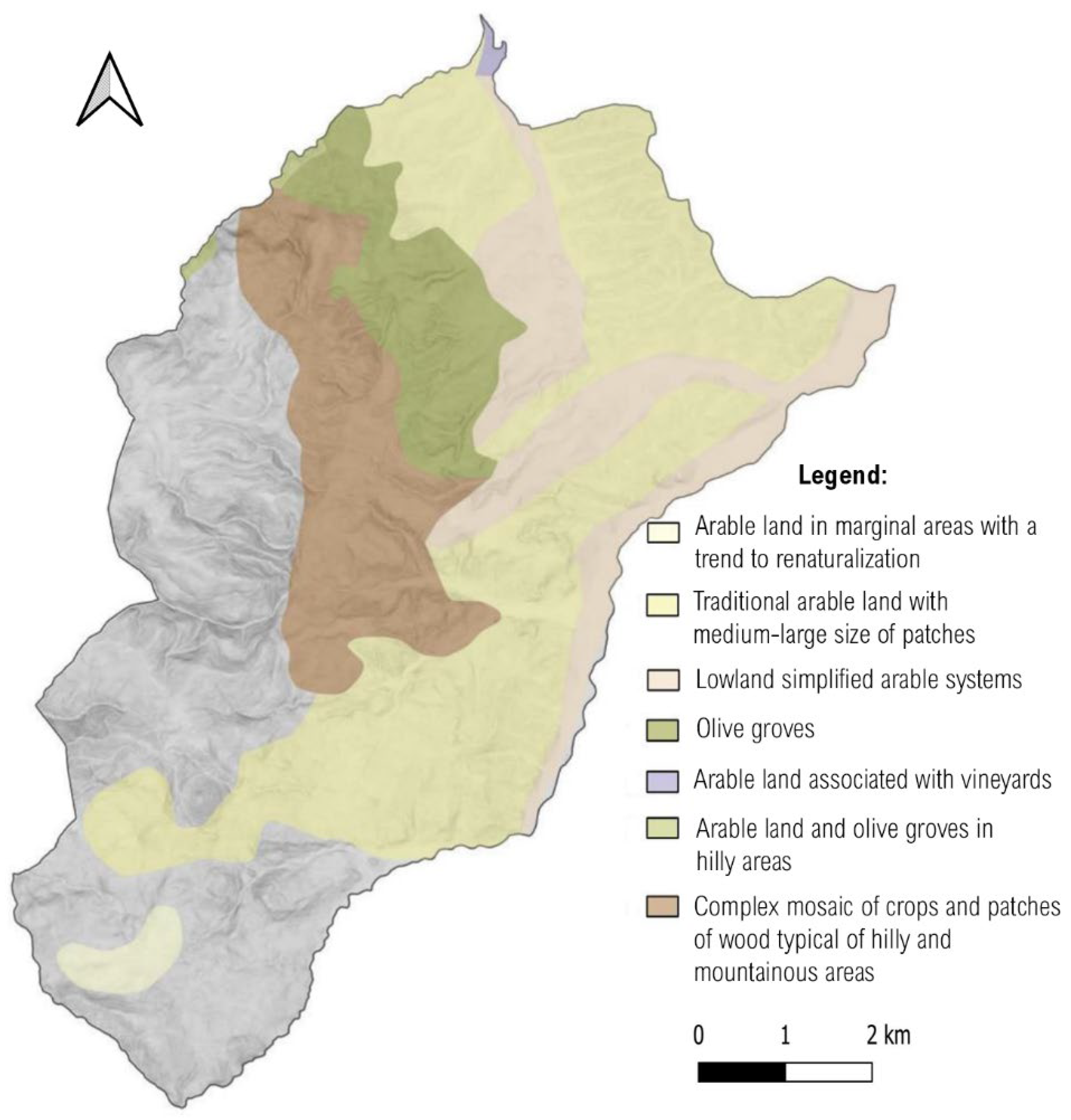
2.2. Case-Study Area Description

Chianni municipality is an administrative unit belonging to Pisa province (NUTS 3) and the Tuscany Region (NUTS 2) in Italy. The position of Chianni in Pisa province, the Tuscany Region and Italy is shown in Figure 1.
Chianni municipality has less than 1500 inhabitants and a surface of about 62 skm, which—from a geographic point of view—may be classified in three zones. The western zone is characterized by hills and low mountains, reaching about 600–700 m.a.s.l, where the vegetation mainly consists of broad-leaved trees (Quercus pubescens Willd.; Quercus cerris L.) and scattered vegetation on the highest and rocky slopes. The northern-eastern zone is characterized by low hills that reach 200 m.a.s.l. at the maximum and by clay-rich land. Arable are mainly cultivated with durum wheat, in alternation with polyphytic meadows and Field bean (Vicia faba minor L.) or Sulla (Hedysarum coronarium L.) annual meadows. The third and last zone is a transitional area between the two above-described zones and includes the main built-up areas, together with olive groves, and natural ecosystem areas. Pedo-climatic features of Chianni municipality, especially soil types, temperature and rain amount and distribution among seasons ask for annual or permanent crops able to survive without irrigation, since this latter would be too costly for the crops that are suitable for the area.
As regards landscape features the “Piano di Indirizzo Territoriale (PIT) con valenza di Piano Paesaggistico (PPR)”, i.e., the Regional Strategic Plan with value of Regional Landscape Plan, of the Tuscany Region individuates an Abacus of morph typologies. Rural morph typologies have been identified through the overlapping of several informative layers, i.e., anthropic characters such as settlements, size and characteristics of cultivated plots, soil typologies and land use, hydro morphologic characters [31]. Chianni municipality includes the following morph typologies: (a) arable land in marginal areas with a trend to renaturalization; (b) traditional arable land with medium-large size of patches; (c) lowland simplified arable systems; (d) olive groves; (e) arable land associated with vineyards; (f) arable land and olive groves in hilly areas; and, (g) complex mosaic of crops and patches of wood typical of hilly and mountainous areas, whose localization on map is shown in Figure 2 [32].

3. Results

In this section, we present the main results of geographical, economic and policy analyses described in the previous section.

3.1. Geographical Analyses about Land Use Change

3.1.1. Changes in the Importance and Location of CLC Classes between 1954 and 2016

This sub-section, for the sake of brevity, presents only the changes underwent by the case-study area during the whole period from 1954 and 2016, without analyzing the breakdown between the sub-periods going from 1954 to 1978 and from 1978 to 2016. However, both sub-periods are characterized by an increase of artificial surfaces (greater between 1978 and 2016; i.e., +19.84 ha in the first period, +73.51 ha in the second one), an increase of forest and semi natural areas (higher between 1954 and 1978; i.e., +244.83 ha in the first period, +71.16 ha in the second one) and by a loss of agricultural areas (higher between 1954 and 1978; i.e., −263.50 ha in the first period, −157.03 ha in the second one), highlighting that most of the changes as regards agricultural and forestry land use happened between 1954 and 1978.
Table 1 summarizes the territorial flows of the whole period 1954–2016, highlighting in bold persistency in the same CLC 1st level class, but also inflows and outflows from or towards other CLC classes. For instance, from 1954 to 2016, 1954 artificial areas remained for 136.73 ha in the same class, while 6.29 ha and 1.67 ha migrate respectively to agricultural areas and forest and semi natural areas. To the 136.73 ha of 1954 artificial surfaces that persisted in the class, 80.23 ha and 22.09 ha were added, coming respectively from agricultural areas and forest and semi natural areas, bringing the total of artificial surfaces in 2016 up to 239.05 ha. In Table 1 we refer to the 1st level of CLC classification; since in the area there were not any wetlands (class 4), they have not been included.
Findings confirm the results of literature described in the Section 1, with a loss of agricultural areas accounting for about 6.74% of the total municipality surface, while both built-up and other artificial surfaces, from the one hand, and forest and seminatural areas, from the other hand, increased due to the processes of urban sprawl and abandonment of marginal areas.
Table 2 focusses on agricultural and forestry uses by presenting the main CLC 3rd level classes belonging to agricultural (class 2) and forestry and natural areas (class 3).
Table 2 shows that the CLC 3rd level class within agricultural surfaces that underwent the highest increase is that of arable lands, which have gained more than 600 ha between 1954 and 2016. Excepting olive groves that do not show any significant variation on the total surface they cover, all the other classes have lost surface, with the highest decrease interesting the more heterogeneous agricultural areas, i.e., annual crops associated with permanent crops and complex cultivation patterns; these classes, as we have pointed out in the Introduction, were typical of sharecropping and aimed mostly to cover the self-consumption needs of farming families. As regards permanent crops, albeit the total area covered by olive groves does not change, this is due to the combined effect of the disappearance of olives groves in the most marginal areas and of the substitution of olives groves to vineyards in the more fertile ones. This substitution of olives to vines is because vineyards ask for a significant and continuous amount of labor that is no longer compatible with present forms of land management, i.e., with the increasing presence of non-professional and hobby farmers. The most widespread class is that of broad-leaved forests, which during the analyzed period shows an increase of about 550 ha. The simplification of land cover patterns is also apparent when analyzing the share of simple arable land plus broad-leaved forests, that accounted for about 58% in 1954 while in 2016 it goes up to about 78%, meaning that these two CLC classes currently account for about 4/5 of the whole municipality territory.
The simplification of agricultural systems as regard size and quality of patches emerges also by the following Figure 3, where (a) shows an orthophoto of landscape in 1954 and (b) shows the same landscape in 2016. The most evident effect of this transformation is the disappearance of the terraces, that were worked manually or with animals, to make way for much larger fields to allow mechanized work.

3.1.2. Evolution of Hedgerows and Isolated Trees between 1954 and 2016

This section focuses on the evolution of specific elements of landscape with an important ecological function, i.e., hedgerows and isolated trees. The analysis of these elements has been limited to the northern-eastern part of the municipality, where simple and simplified arable systems are and have been prevalent in the past. Being the most fertile area of the municipality, it underwent heavy restructuration processes with a significant loss of hedgerows and isolated trees, according to the main modernization trends of agriculture described in the Section 1.
Figure 4 shows the evolution of hedgerows on maps, highlighting the significant simplification of their network, especially in the period between 1954 and 1978. Table 3 presents a quantification of this phenomenon in terms of density, that decreased from 46.14 m ha−1 in 1954 to 29.65 m ha−1 in 1978, with a decrease of more than 35%. The period from 1978 to 2016 showed a more limited decrease causing the density to go down from 29.65 to 27.04 m ha−1, since, as above described, most of the modernization processes and consequent changes in land use and patterns were completed before 1978.
As regards the situation of isolated trees (see Table 4), their loss is still more significant than that of hedgerows, since only 71 isolated trees (among which only 55 were already present in 1954) were left in 2016 against the initial 376 that were censed in 1954. Although the phenomenon of tree disappearance slowed down during the last period, it was still significant, since after the loss of 213 isolated trees between 1954 and 1978, in the following period there was a further decrease of 92 isolated trees. This causes concerns about the sort of few isolated trees left, in the case that the disappearance trend continues.
Figure 5 shows the evolution of isolated trees on maps at different times, where each tree is identified by a green star.
Due to the significant decrease of isolated trees and hedgerows in the analyzed area we tried to understand the importance of economic drivers in bringing about it and to explore if public aid provided under the umbrella of Common Agricultural Policy (both under Pillar I and Pillar II) have been/could be effective in reversing current trends; these topics are analyzed in the following sections, limited to the case of hedgerows.

3.2. Main Direct and Indirect Costs Borne by Farmers for Increasing or Maintaining Hedgerows

Since farmers are the main agents in deciding whether to maintain hedgerows in their farmland, or not, and starting from the hypothesis that farmers—as entrepreneurs—aim to increase their profit, we tried to estimate the main direct and indirect costs of the decision of planting hedgerows. Although the above hypothesis is a simplification, since there are other factors influencing farmers decision to adopt environmental-friendly behaviors [20,21,33], to quantify costs is important in terms of policy design. Indeed, to be effective a policy should provide aid able to compensate costs (otherwise, farmers won’t be willing to enter the scheme), but to be efficient, the amount of aid should not exceed costs (otherwise farmers will receive more public funding of that needed to make them enter the scheme). Some agri-environment schemes in the context of the EU Common Agricultural policy currently include measures promoting the introduction of non-crop habitats in the agricultural landscape [34]. While costs for maintaining hedgerows are mainly related to the loss of productive area (indirect costs), in the case of new planting also direct costs relating to plant purchase and interventions needed up to the hedgerow establishment should be considered. From a theoretical point of view, to consider indirect costs as related only to the loss of productive area is a simplification. According to a Systematic Literature Review performed by [16], all analyzed studies reported a lower crop yield close to hedgerows, and a gradually restoring crop yield when the ratio between Distance (D) from hedgerow and its Height (H) increased, up to a situation where the net total effect was positive; these authors tested the relation between yield and D/H getting as a result that, over the entire affected zone, the net effect was positive when not considering the loss of production due to the area occupied by the hedgerow. This could be due to an improved microclimate or to the shelter effect. Nevertheless, since effects on the neighboring fields depend on many features of hedgerows (height, width, orientation, type, management form, age) and fields (dimension, slope, climate, type of crop, etc.), we decided that it was not possible to properly consider these factors outside a detailed plan of their introduction and in a situation where information about the effects in the specific context were not available. Some items are missing also as regards direct costs, in the case that management costs as pruning are significant, and this mainly depends on how the hedgerows are managed (e.g., coppicing, or pollarding trees). Also in this case, maintenance direct costs have not been considered.
The following Table 5 and Table 6 show respectively the data related to main direct and indirect costs. Direct costs were estimated within a 6-year time span by assuming that farmers were planting hedgerows by employing contractor services for land preparation activities while planting and irrigation were done using internal farm resources. The choice to use sub-contractor activities was motivated by cost dependency from farm structures and the fact that subcontractor tariffs may be considered as a good proxy of standard costs. Vice versa, the planting and later activities, which are mostly related to manual work and dilute in time, have been based on the appropriate items of the Tuscany regional schedule of rates (https://www.regione.toscana.it/-/il-prezzario-2022-dei-lavori-della-toscana (accessed on 31 March 2022)). The specific costs of Table 5 are referred to the end of the year, while the last column shows the value anticipated at the beginning of the first year (Co). Values have been discounted at a 3% rate.
From Table 5 it is apparent that the cost of the initial investment for increasing the amount of hedgerows of 100 linear meters is about 1.481 EUR, i.e., 14.81 EUR/linear meter; cost that could be lowered in the case of use of manual and farm machinery spare capacity.
In the analysis of indirect costs, we decided to consider three different scenarios: (a) the permanence of the current situation as regards hedgerow density: (b) the complete disappearance of hedgerows from the area and (c) an “improved situation” with an average density of hedgerows of 35 m ha−1, i.e., 8 m ha−1 higher than the current situation, deeming it impossible to have as a goal the restoration of the initial situation at 1954. To reach this goal, it would be necessary to plant 13,770 new meters of hedgerows, with a total cost of about 203,934 EUR for the whole area, resulting on an average cost of about 118 EUR for each hectare of the analyzed area. In the case of the scenario (b), costs for uprooting hedgerows were not considered.
Table 6 provides an evaluation of income that is possible to get on average from a hectare of a biennial rotation of Durum Wheat and Field Bean, i.e., the most common rotation in the area, from which it is possible to estimate indirect-cost variation due to an increase or a decrease in hedgerow density. It shows that on average farmers get from a hectare of biennial rotation of durum wheat and field bean about 748 euros, i.e., 0.0748 EUR/square meter. To increase hedgerow density from 27 to 35 linear meters/hectare, we have hypothesized a loss of productions for a width of 20 m along the hedgerow, i.e., the loss of 8 × 20 = 160 square meters of productive land, accounting for a permanent indirect cost of about 160 sm × 0.0748 EUR/sm = 11.97 EUR/hectare/year. Vice versa, the decision to eliminate all hedgerows would result in the chance of increasing cultivated land of an area of 27 × 20 = 540 sm/hectare, causing an increase of gross margin of about 540 sm × 0.0748 EUR/sm = 40.40 EUR/hectare/year. The economic risk of losing hedgerows would be higher in the case that a change on the actual policies promoting crop diversification and the cultivation of leguminous crops brings about a specialization on durum wheat, especially in case of increasing prices of this latter.
Direct and indirect costs above described represent a per hectare average on the whole area and consequently they are only a proxy of the costs that a specific farmer should bear, since they would depend on the exact location of hedgerows and farms, and on farm structure and organization. Thus, farmers would be differently affected by the decision to change the current situation according to the improved scenario. On the other hand, it should be considered that also benefit deriving from the improved scenario could be very different depending on hedgerow localization and their qualitative features.

3.3. Analysing the Role Played by CAP Greening and RDP Measures in Promoting Hedgerows

In the previous section we have assessed the main direct and indirect costs related to an increased presence of hedgerows on the analyzed area, with the aim of improving the non-productive ESs that they could provide [8,9,14,16]. In this section we analyze the role played by greening aid under Pillar I and a specific RDP measure under Pillar II in promoting hedgerows in the Tuscany Region context. The choice of focusing on only these two policies stems from their general validity, also in areas without any special “status”.
In Italy, at present greening account for 30% of national ceiling against the 48% of basic payments; thus, with a basic payment of about 204 EUR, it would account for about 107 € ha−1. Greening payment requires a minimum crop diversification, the maintenance of permanent pasture and a minimum surface (5%) dedicate to Ecological Focus Areas (EFA) to be eligible for it. Hedgerows are included within the types of land destination which qualify for EFA, and consequently the greening payment of Pillar I may affect the convenience to reintroduce or maintain hedgerows insofar as indirect costs related to the loss of productive surface could be compensated by the greening payment. An analysis of the initial perception about EFA of farmers operating in another Tuscan areas specialized on durum wheat is provided by [35]. However, several cases of exemption do exist [11]. The inclusion of some productive uses among those qualifying for EFA, e.g., the cultivation of fodder legumes, contributed to the change of some farmers’ perception and made hedgerows presence quite unimportant in terms of meeting EFA requirements in many areas, such as our case-study area. Indeed, greening payment has been included in the assessment of the average gross margin of the biennial rotation durum wheat—field bean presented in Table 6 since field bean qualifies as EFA areas.
As regards policy incentives under Pillar II, a description of the whole set of environmentally oriented measures within the 2014–2020 RDPs is provided by [11]. In this section, we refer specifically to RDP measure 4—Investment in physical assets, sub-measure 4.4. Aid for non-productive investment in meeting agricultural, environmental, and climate targets, intervention 4.4.1 promoting the “Maintenance and restoration of identity element of landscape, and biodiversity conservation and enhancement” (https://www.regione.toscana.it/-/psr-2014-2020-della-toscana-misure-sottomisure-e-operazioni (accessed on 6 April 2021)). The direct costs of new hedgerows could be at least partly covered by 4.4.1. RDP measure, since it provides capital grants for hedgerows planting.
In Tuscany, very few farmers have exploited the chance provided by measure 4.4.1. since only 35 demands were presented and accepted, for a total payment of about 1 million EUR, which represents an amount equal to 0.12% of what has been paid for direct payments. The main part of capital grants distributed under measure 4.4.1 refers to interventions located in Florence and Siena provinces; these two provinces are characterized by very well-known landscapes, e.g., Chianti in Florence province and Val d’Orcia in Siena province [24], i.e., historical landscapes protected under the laws related to cultural and heritage landscape that is worthwhile preserving and enhancing.
Thus, as in the case of greening, the effect of RDP measures in promoting an increase of hedgerow density is very scarce, showing a lack of effectiveness of these two policy tools or an attitude towards modernization and simplification by farmers that policy aid is not able to overcome.
The situation will likely change with the CAP new programming, that has a different structure both for pillar I and pillar II. As regards pillar II, e.g., art. 31 forbid aid for landscape investments. Besides, some uncertainty is related to the passage from RDPs to an NDP.

4. Discussion

The sharp decrease of hedges and isolated trees caused by the processes of agricultural modernization that we have highlighted as regards our case-study area is a phenomenon that has been witnessed worldwide and that concerns many people due to the consequent reduction of ESs that these elements provide.
In this section, starting from the results presented in the previous section, we put on the table some comments and issues about the chances to revert hedgerows and isolated trees disappearance processes and the best policy tools for doing it that could be significant also for areas outside the case-study area, both in Italy and in other countries.
As we have stated in the Introduction, hedgerows and trees had a precise productive role on polycultural systems [36] that they do not longer have. Thus, the first comments relate to the farm level and the choice made by farmers to remove hedgerows and trees, due to the changes on the technological-productive and socio-economic contexts in which they were planted. Economic data about direct and indirect costs of hedgerows reimplanting are probably the most immediate information that farmers consider in their decisions. Nevertheless, they give only a partial and short-term view of the potential effects of hedgerows and trees presence or reintroduction. As regards long-term and positive effects, some authors refer an improvement on erosion, water and organic matter content of soil, abatement of extreme temperatures, pollinator services, etc. [37,38,39,40,41] that may contribute to yield maintenance or its improvement in time, compensating the negative effect due to the productive area reduction. Vice versa, some authors affirm that scientific evidence of these positive effects is still lacking and ask for more extensive research documenting them [42], while other authors stress that effects are dependent on the specific context and consequently cannot be easily generalized. However, the scientific community is increasingly aware of the need to estimate indirect effects of agro-ecosystem management decisions. A recent paper [43], e.g., stated that some management techniques promoted or required by CAP, such as minimum tillage techniques, cover crops and buffer strips, which are perceived as characterizing a more conservative and less productive approach to agriculture, were able to significatively decrease erosion levels, thus preserving future production.
As we have stated, the first information that farmers often consider is related to costs. Among costs that may be caused by hedgerows and trees presence, there are those due to an increase of time employed by machinery. Agricultural modernization is characterized by a shift from labor intensive to capital intensive techniques that greatly profit from field large size and economies of scales. In many agricultural systems characterized by small farms and a prevalence of arable land, an increasing number of farmers are using sub-contractors for cultivation works. This dependence on sub-contractors may worsen the situation of hedgerows and isolated trees since, while landowners could have an interest in preserving them, e.g., for improving long-term land fertility or increasing landscape beauty, sub-contractors usually value only the efficient use of their machinery. From this point of view, hedgerows may profit by a global rethinking of all farm linear infrastructures (roads, ditches, hedgerows) with a retro-innovation approach aimed at identifying new ways of including hedges into the agricultural mesh, making their presence compatible with an efficient use of machinery [44].
As regards command and control tools, they are seen as less effective than measure promoting voluntary actions through aid [18]. Consequently, they should be limited to cases where it is paramount to maintain a very high value resource. Agnoletti [28] points out as rules constraining agricultural activities on the base of nature and environment protection risk to determine the disappearance of valuable heritage landscape whose creation and maintenance is related to human productive activities. An excessive level of constraints on agricultural activities may determine either forms of renaturalization that hide abandonment processes or have boomerang effects by preventing the (re)introduction of elements whose management risks to rise problems in the future. The Tuscany regulation about Forestry, e.g., sets rules for cutting and pruning of forest plants outside woodlands, when some conditions (age, type of trees, etc.) recur. Other laws at different institutional levels put burdens as regards hedgerow and tree management and this could have negative effects on farmers’ choices.
As regards voluntary actions rewarded by a financial aid, in the Section 3 we have provided some information about the potential economic impact of greening and Tuscan RDP measure 4.4.1 aid on hedgerows maintenance or increase.
Hedgerows are included within the types of land destination which qualifies for EFA. The inclusion of some productive crops within the EFA admitted uses has significantly weakened the impact of greening on biodiversity and the maintenance of important landscape and ecological infrastructure elements. Greening requirements had an effect mainly on large, intensive, and specialized farms where diversification and greening requirements resulted in a certain introduction of legumes crops [45], although the late addition of the ban of pesticide use on EFA productive crops made this solution less profitable. Vice versa, in less intensive contexts where diversification was already practiced, such as our case-study area, greening measures seem not to have produced significant effects. Since at EU level, 73–75% of EFA area is represented by productive crops, which can help to meet at the same time diversification and EFA requirements, the scarce effectiveness of EFA requirements is likely not limited only to Italy. The new CAP architecture may help in designing measures valid for different contexts, since it has a new delivery model rooted in the subsidiarity principle, which argues that decentralized design and implementation of measures should be encouraged if higher effectiveness is desired [46]. In the next programming, greening will be included in the Good Agricultural and Environmental Condition (GAEC) 9, that requires the maintenance of a minimum share of areas destined to non-productive uses and the maintenance of the typical elements of landscape. However, exceptions are allowed in the case of a minimum share of land destined to Eco-schemes, that will likely weaken the effects of GAEC 9 in the same way productive uses meeting EFA requirements have weakened greening.
As regards Pillar II measures, the Section 3 highlighted the scarce success of aid financing non-productive investments aimed to the restoration and conservation of typical landscape elements. Previous analyses on the interventions implemented in past programming periods highlighted as hedgerow new planting was scarce and often carried out mainly in agro-tourism farms with “aesthetic” aims and outside any meaning as regards hedgerows importance as ecological infrastructures or in preserving cultural landscapes. In a book edited by Torquati [47] about Agriculture and Landscape in Umbria e Lazio, which includes some photographs of interventions financed by RDP, the only pictures related to hedgerows (photo 4 and photo 5) are related to hedgerows at the side of agro-tourism entrance roads. In a paper about landscape governance based on the case-study of Val d’Orcia [48], another hilly area of Tuscany mainly cultivated to durum wheat, we stressed how foreign landowners have spread traditional elements of the Tuscany landscape (e.g., Cupressus rows) in ways and amounts that are in contrast with the traditional landscape of the area. The quantitative approach of RDP measures for landscape is criticized by Agnoletti, who stresses how hedgerows and trees are not always positive for landscape, but there is the need to assess their value at local level, keeping in mind the context where they are planted [49]. Indeed, landscape and its beauty it is not only a matter of quantity of single elements but also of the spatial relationships among them.
In most cases, landscape conservation and ecological network interventions should be considered on sufficiently large areas. Ecological networks require core natural areas, buffer zones, ecological corridors and stepping zones [11] characterized by a minimum size and precise relations among them. The reintroduction of hedgerows to improve the ecological performances of the rural territory is hindered in case of areas characterized by small agricultural exploitations, as it is the case in many Tuscan and Italian areas, where the situation is sometimes worsened by the fact that farmland is fragmented in parcels quite distant from each other [32]. Consequently, except on the cases of very large farms where these interventions could be significant also at farm level, there is the need to organize actions stemming from the coordination or collaboration of a plurality of farmers and able to reach a minimum threshold. According to [50] the ineffectiveness of Agri-Environment Schemes (AES) in achieving landscape-level outcomes is mainly due to the fact that the design of conventional AES has not considered the landscape as a unit for conservation intervention but has targeted outcomes at the farm level providing incentives for individual actions.
The problem of minimum scale for landscape and ecological infrastructures may be faced with different kind of approaches, such as: (a) spatial coordination incentive under CAP Pillar I; (b) RDP collective projects under CAP Pillar II; (c) Landscape Projects, under the tools for territorial planning.
Coordination incentives differ from collective measures insofar as coordination requires landholders to work together towards the same environmental goal, but in isolation, as in some area measures under Pillar I, while collaboration requires landholders to work together or to undertake collective work to achieve common environmental goals, as in some territorial projects under RDP. A systematic review of spatial coordination incentives for landscape-scale environmental management is provided by [50]. The paper describes the features and drawbacks of incentives such as Agglomeration bonus, Threshold Bonus and Threshold payments, where agglomeration bonus refers to an additional payment given in the case that a certain level of participation and/or of spatial connectivity among landholders’ habitats is reached [50]. It is interesting to note that with modern technologies, such as platform for auctions coupled with GIS tools able to check the contiguity-continuity of interventions, it is possible to automatically check if farmers ready to undertake an action would qualify for an agglomerative/threshold bonus.
Emery and Franks [51] provide a description of the potential for collaborative AES in England. They describe factors hindering the spread of collaborative AES, e.g., the strong wish for independence or the lack of communication. Consequently, actions of community-building, increasing the willingness to collaborate among farmers and with other stakeholders such as governmental actors could be very useful; these require a participative approach at local level with a consensus building that cannot be reached automatically, but rests on the relationships among community members. While a coordination approach could be developed from the top, a collaborative approach needs to involve the “grass-root” of the community. However, a recent survey within WP3 of Console project (https://console-project.eu/ (accessed on 13 July 2022)) highlighted how among contract solutions, collective contracts have the lowest acceptability by farmers both in Italy and in the other EU states involved in the project and are perceived by stakeholders as difficult to be implemented. This issue should be faced when designing measures, e.g., by guaranteeing a basic payment to farmers complying with rules also in the case that requirements are not met at collective level.
The presence of a professional(ized) organization could contribute to improve spatial coordination [52], as well other intermediate bodies between farmers and regional/national/European institutions, as in the case of Dutch agri-environmental cooperatives [53]. The specificity of Dutch cooperatives was that they were not only acting as coordinated bodies in the concertation of actions and measures to be implemented, but they were responsible for the financial resources obtained and the related tasks both at operational and bureaucratic level. According to the assessment made by the Dutch government, this increased efficiency and reduced administrative costs [53]. About this issue, see also, e.g., [54,55,56].
The third and last approach refers more to territorial governance and planning tools rather than to common agricultural policy. The founding principle of the current Tuscan Landscape Plan, e.g., is that landscape is an added value for the regional territory and, as such, if it is well managed, it can become a factor of attractiveness and development for the whole community. Moving from the identification of landscape criticalities highlighted by PIT-PPR and from farmers needs highlighted by the RDP, local landscape projects should be built through a coworking of public and private stakeholders by means of a co-planning processes and participative design able to create a shared vision of territorial governance and development [57]. Landscape projects represent “place-based” tools that, when related to environmental improvement of actions to contrast climate changes in a specific territory, could be promoted also under CAP pillar II interventions—measure 16—cooperation. Nevertheless, up to now, Tuscan landscape projects seem to respond more to a top down planning approach since they lack including a more effective and permeating participative approach [58].
Magaudda et al. [11] highlight that Italy is lagging behind in the European Union where several countries have already implemented place-based approaches. However, in their paper, they present three case studies located in different administrative Regions (Piedmont, Marche and Latium) where a collaborative and strategic approach made it possible to overcome conflicts between sectoral and institutional skill areas, also thanks to the presence of a promoter—intermediate body able to manage collaborative governance between different administrative levels [11].
The process of landscape design is complex because it involves many points of view, at different spatial and time scales and situation, and relates to different aspects (productive, aesthetic, ecological, environmental, cultural, etc.) and may be effectively performed only by integrating approaches and policy tools and by involving stakeholders with a participative approach. A general model for territorial and landscape governance inspired by the Ecosystem Services cascade stressing the need to integrate planning and programming tools and to introduce participative approaches to agricultural landscapes and their management is presented in Rovai et al. [59] (p. 148).
As regards suasion policy, it is important to stress that modernization processes have been based for years on the assumption that nature should be bent to the human will by an increasing use of external inputs. Organic farmers have usually a different attitude towards nature and look for a synergic relation rather than an antagonistic one [60]. Another factor that can positively influence farmers’ attitude about hedgerows and isolated trees relates to their contribution in terms of territorial identity. Indeed, the European Landscape Convention [61] stresses how landscape maintenance and enhancement should not be limited to landscape of recognized outstanding beauty. While a positive attitude towards conserving traditional landscapes could be related to a sense of belonging, landscape maintenance may also have economic reasons, due to the presence of agro-tourism activities that are positively influenced by the beauty of surrounding areas. For instance, [62] highlighted that farmers have a more positive attitude towards custodianship when involved in tourist and hunting activities. As we have stressed in the Section 3, Tuscan provinces with a high expenditure under measure 4.4.1 show a high presence of organic farms and agro-tourisms.
According to [9], the awareness of positive effects on production and natural resource protection operated by greenways would facilitate their integration in farm and landscape design. The importance of farmers awareness about positive and negative impacts of their activity and their attitude towards it is highlighted by many researchers, e.g., [20,21,33]. Actions promoting knowledge and awareness among farmers could be useful for increasing participation in schemes and measures promoting the adoption of beneficial practices and have effects lasting beyond the period farmers get financial aid.

5. Conclusions

Modernization processes that have shaped agriculture during the last century have focused on productive efficiency causing the loss of ecological infrastructures characterizing previous agro-ecosystems, as it was confirmed by our case-study analysis.
Environmental and climate change criticalities brought about an increasing awareness about the need to promote more sustainable agro-ecosystems, where the presence of hedgerows and trees is recognized as positive and very important not only for productive reasons, how it was in the past, but also for protecting the environment and the landscape. From this point of view, there is an attempt to reconcile productive and environmental issues within planning tools, as it is apparent, e.g., from the Tuscan PIT-PRR.
Our results about direct and indirect costs of planting or maintaining hedgerows, although to be refined, show that these costs seem not so high and could be covered by aid deriving from Pillar I “greening” or Pillar II measures on non-productive investments or other similar policy tools. However, the focus of measure at farm level could cause a lack of effectiveness.
Thus, in the authors’ opinion, the main limits to the (re)introduction or the maintenance of hedgerows and isolated trees are related to:
  • The productive model. In areas where farmers still manage agricultural works, it seems that they perceive cost reductions as more important of the potential benefit related to the maintenances of green infrastructures, except in the case that those latter promote other activities such as agro-tourism or hunting or that farmers adopt techniques of organic farming. The situation is still more problematic in areas characterized by high fragmentation and heavy dependence from sub-contractors for agricultural works, since sub-contractors are strongly interested in reducing times needed to agricultural works to increase their competitiveness.
  • The necessity to shift the focus from the farm level to the territorial level. Effective actions against criticalities about ecological networks, landscape protection and other issues should be faced to a scale larger than that of a single productive unit. This asks for a change in the way CAP aid are attributed, since pillar I and most of the Pillar II financial resources are intended for single beneficiaries/farmers. This change could be favored by the current vision aiming to shift CAP aid from action-based to result-based measures. Result-based approach attributes aid on the base of results that have been obtained and needs to have reliable measures of the current state of environment and of the improvements that have been obtained. When the state of the environment depends on the actions of many farmers, results could not be traced back to single farmers, but needs an approach at territorial level.
  • The necessity to move towards a collective vision of problems at landscape/territorial level, where the focus is on space. A collective vision is necessary to build coordinate and comprehensive projects able to operate in a multi-disciplinary, multi-actor, multi-institutional level, both at planning level than as regards the distribution of financial resources. Investing financial resources both in drafting proper plans and in creating a collective and participative culture is a pre-condition for ensuring the effectiveness of interventions. However, this will cause the share of aid available to final beneficiaries to be reduced, although farmers prefer that the whole amount of financial aid goes to beneficiaries seeing all the rest as lost in useless bureaucracy. Besides, institutions sometime have problems in building adequate processes of concertation and planning and prefer measures that are easier to be implemented. Indeed, the lack of financial and human resources for a proper planning and the risk that financial resources are taken away from the regional budget for the fact that they have not been used within the stated time framework usually determine a shift towards measures for which expenditure is easier, also in the case that their positive effects are scarce.
Consequently, it is paramount to reduce problems deriving from the interaction among different institutional levels, thus improving effectiveness and efficiency, and to build both at institutional and enterprise level a human capital able to plan and program interventions at landscape and territorial scale.

Author Contributions

Conceptualization, A.V., M.R. and M.A.; methodology, M.R. and A.V.; software, A.V.; validation, M.R., M.A. and A.V.; investigation, M.A. and A.V.; data curation, M.A. and A.V.; writing—original draft preparation, M.R. and M.A.; writing—review and editing, M.R., M.A. and A.V.; supervision, M.R. All authors have read and agreed to the published version of the manuscript.

Funding

This research received no external funding.

Institutional Review Board Statement

Not applicable.

Informed Consent Statement

Not applicable.

Data Availability Statement

Data for processing are available on https://www.regione.toscana.it/-/geoscope, accessed on 31 January 2022).

Conflicts of Interest

The authors declare no conflict of interest.

References

  1. van Vliet, J.; de Groot, H.L.F.; Rietveld, P.; Verburg, P.H. Manifestations and underlying drivers of agricultural land use change in Europe. Landsc. Urban Plan. 2015, 133, 24–36. [Google Scholar] [CrossRef] [Green Version]
  2. Van Eetvelde, V.; Antrop, M. Analyzing structural and functional changes of traditional landscapes—Two examples from Southern France. Landsc. Urban Plan. 2004, 67, 79–95. [Google Scholar] [CrossRef]
  3. Sallustio, L.; Munafò, M.; Riitano, N.; Lasserre, B.; Fattorini, L.; Marchetti, M. Integration of land use and land cover inventories for landscape management and planning in Italy. Environ. Monit. Assess. 2016, 188, 48. [Google Scholar] [CrossRef] [PubMed]
  4. Serra, P.; Pons, X.; Saurí, D. Land-cover and land-use change in a Mediterranean landscape: A spatial analysis of driving forces integrating biophysical and human factors. Appl. Geogr. 2008, 28, 189–209. [Google Scholar] [CrossRef]
  5. Hersperger, A.M.; Bürgi, M. Going beyond landscape change description: Quantifying the importance of driving forces of landscape change in a Central Europe case study. Land Use Policy 2009, 26, 640–648. [Google Scholar] [CrossRef]
  6. Jepsen, M.R.; Kuemmerle, T.; Müller, D.; Erb, K.; Verburg, P.H.; Haberl, H.; Vesterager, J.P.; Andrič, M.; Antrop, M.; Austrheim, G.; et al. Transitions in European land-management regimes between 1800 and 2010. Land Use Policy 2015, 49, 53–64. [Google Scholar] [CrossRef]
  7. Agnoletti, M. The degradation of traditional landscape in a mountain area of Tuscany during the 19th and 20th centuries: Implications for biodiversity and sustainable management. For. Ecol. Manag. 2007, 249, 5–17. [Google Scholar] [CrossRef]
  8. Lecq, S.; Loisel, A.; Brischoux, F.; Mullin, S.; Bonnet, X. Importance of ground refuges for the biodiversity in agricultural hedgerows. Ecol. Indic. 2016, 72, 615–626. [Google Scholar] [CrossRef]
  9. Burel, F.; Baudry, J. Social, aesthetic and ecological aspects of hedgerows in rural landscapes as a framework for greenways. Landsc. Urban Plan. 1995, 33, 327–340. [Google Scholar] [CrossRef]
  10. Hinsley, S.; Bellamy, P. The influence of hedge structure, management and landscape context on the value of hedgerows to birds: A review. J. Environ. Manag. 2000, 60, 33–49. [Google Scholar] [CrossRef]
  11. Magaudda, S.; D’Ascanio, R.; Muccitelli, S.; Palazzo, A.L. ‘Greening’ Green Infrastructure. Good Italian Practices for Enhancing Green Infrastructure through the Common Agricultural Policy. Sustainability 2020, 12, 2301. [Google Scholar] [CrossRef] [Green Version]
  12. Foley, J.A.; DeFries, R.; Asner, G.P.; Barford, C.; Bonan, G.; Carpenter, S.R.; Chapin, F.S.; Coe, M.T.; Daily, G.C.; Gibbs, H.K.; et al. Global consequences of land use. Science 2005, 309, 570–574. [Google Scholar] [CrossRef] [Green Version]
  13. Foley, J.A.; Ramankutty, N.; Brauman, K.A.; Cassidy, E.S.; Gerber, J.S.; Johnston, M.; Mueller, N.D.; O’Connell, C.; Ray, D.K.; West, P.C.; et al. Solutions for a cultivated planet. Nature 2011, 478, 337–342. [Google Scholar] [CrossRef] [Green Version]
  14. Arnaiz-Schmitz, C.; Herrero-Jáuregui, C.; Schmitz, M.F. Losing a heritage hedgerow landscape. Biocultural diversity conservation in a changing social-ecological Mediterranean system. Sci. Total Environ. 2018, 637–638, 374–384. [Google Scholar] [CrossRef]
  15. Álvarez, F.A.; Mediavilla, G.G.; Estébanez, N.L. Environmental, demographic and policy drivers of change in mediterranean hedgerow landscape (Central Spain). Land Use Policy 2021, 103, 105342. [Google Scholar] [CrossRef]
  16. Laura, V.V.; Bert, R.; Steven, B.; Pieter, D.F.; Victoria, N.; Paul, P.; Kris, V. Ecosystem service delivery of agri-environment measures: A synthesis for hedgerows and grass strips on arable land. Agric. Ecosyst. Environ. 2017, 244, 32–51. [Google Scholar] [CrossRef]
  17. Schmitz, M.F.; Herrero-Jáuregui, C.; Arnaiz-Schmitz, C.; Sánchez, I.A.; Rescia, A.J.; Pineda, F.D. Evaluating the Role of a Protected Area on Hedgerow Conservation: The Case of a Spanish Cultural Landscape. L. Degrad. Dev. 2017, 28, 833–842. [Google Scholar] [CrossRef]
  18. Tempesta, T. People’s preferences and landscape evaluation in Italy: A review. New Medit Mediterr. J. Econ. Agric. Environ. = Rev. Méditerranéenne Dʹeconomie Agric. Et Environ. 2014, 13, 50–59. [Google Scholar]
  19. van Zanten, B.T.; Verburg, P.H.; Espinosa, M.; Gomez-y-Paloma, S.; Galimberti, G.; Kantelhardt, J.; Kapfer, M.; Lefebvre, M.; Manrique, R.; Piorr, A.; et al. European agricultural landscapes, common agricultural policy and ecosystem services: A review. Agron. Sustain. Dev. 2014, 34, 309–325. [Google Scholar] [CrossRef] [Green Version]
  20. Mills, J.; Gaskell, P.; Ingram, J.; Dwyer, J.; Reed, M.; Short, C. Engaging farmers in environmental management through a better understanding of behaviour. Agric. Hum. Values 2017, 34, 283–299. [Google Scholar] [CrossRef]
  21. Dessart, F.J.; Barreiro-Hurlé, J.; Van Bavel, R. Behavioural factors affecting the adoption of sustainable farming practices: A policy-oriented review. Eur. Rev. Agric. Econ. 2019, 46, 417–471. [Google Scholar] [CrossRef]
  22. Laffont, J.-J.; Martimort, D. The Theory of Incentives; Princeton University Press: Princeton, NJ, USA, 2009. [Google Scholar]
  23. Sereni, E. History of the Italian Agricultural Landscape; Princeton University Press: Princeton, NJ, USA, 1997. [Google Scholar]
  24. Agnoletti, M. Tuscany; Agnoletti, M., Ed.; Springer: Dordrecht, The Netherlands, 2013; pp. 319–341. [Google Scholar]
  25. Gaggio, D. The Shaping of Tuscany: Landscape and Society between Tradition and Modernity; Cambridge University Press: Cambridge, UK, 2016. [Google Scholar]
  26. Oglethorpe, S. The End of Sharecropping in Central Italy after 1945: The Role of Mechanisation in the Changing Relationship between Peasant Families and Land. Rural Hist. 2014, 25, 243–260. [Google Scholar] [CrossRef]
  27. McCann, T.; Cooper, A.; Rogers, D.; McKenzie, P.; McErlean, T. How hedge woody species diversity and habitat change is a function of land use history and recent management in a European agricultural landscape. J. Environ. Manag. 2017, 196, 692–701. [Google Scholar] [CrossRef]
  28. Agnoletti, M. Rural landscape, nature conservation and culture: Some notes on research trends and management approaches from a (southern) European perspective. Landsc. Urban Plan. 2014, 126, 66–73. [Google Scholar] [CrossRef]
  29. Büttner, G.; Feranec, J.; Jaffrain, G.; Mari, L.; Maucha, G.; Soukup, T. The Corine Land Cover 2000 Project. EARSeL Eproceedings 2004, 3, 331–346. [Google Scholar]
  30. Mancinelli, R.; Di Felice, V.; Radicetti, E.; Campiglia, E. Impact of land ownership and altitude on biodiversity evaluated by indicators at the landscape level in Central Italy. Land Use Policy 2015, 45, 43–51. [Google Scholar] [CrossRef]
  31. Baldeschi, P.; Brunori, G.; Fastelli, L.; Gisotti, M.R.; Rovai, M. I caratteri morfotipologici dei paesaggi rurali. In La Struttura del Paesaggio: Una Sperimentazione Multidisciplinare per il Piano Della Toscana; Marson, A., Ed.; Laterza: Bari, Italy, 2017; pp. 202–216. [Google Scholar]
  32. Fastelli, L.; Rovai, M.; Andreoli, M. A Spatial Integrated Database for the Enhancement of the Agricultural Custodianship Role (SIDECAR)—Some preliminary tests using Tuscany as a case-study Region. Land Use Policy 2018, 78, 791–802. [Google Scholar] [CrossRef]
  33. Sutherland, L.A.; Toma, L.; Barnes, A.P.; Matthews, K.B.; Hopkins, J. Agri-environmental diversification: Linking environmental, forestry and renewable energy engagement on Scottish farms. J. Rural Stud. 2016, 47, 10–20. [Google Scholar] [CrossRef] [Green Version]
  34. Rey Benayas, J.M.; Bullock, J.M. Restoration of Biodiversity and Ecosystem Services on Agricultural Land. Ecosystems 2012, 15, 883–899. [Google Scholar] [CrossRef]
  35. Menozzi, D.; Fioravanzi, M.; Donati, M. Farmer’s motivation to adopt sustainable agricultural practices. Bio-based Appl. Econ. 2015, 4, 125–147. [Google Scholar] [CrossRef]
  36. Barbera, G.; Cullotta, S. The Traditional Mediterranean Polycultural Landscape as Cultural Heritage: Its Origin and Historical Importance, Its Agro-Silvo-Pastoral Complexity and the Necessity for Its Identification and Inventory. In Biocultural Diversity in Europe. Environmental History; Agnoletti, M., Emanueli, F., Eds.; Springer: Cham, Switzerland, 2016; Volume 5, pp. 21–48. [Google Scholar] [CrossRef]
  37. Sánchez, I.; McCollin, D. A comparison of microclimate and environmental modification produced by hedgerows and dehesa in the Mediterranean region: A study in the Guadarrama region, Spain. Landsc. Urban Plan. 2015, 143, 230–237. [Google Scholar] [CrossRef]
  38. Sánchez, I.A.; Lassaletta, L.; McCollin, D.; Bunce, R.G.H. The effect of hedgerow loss on microclimate in the Mediterranean region: An investigation in Central Spain. Agrofor. Syst. 2009, 78, 13–25. [Google Scholar] [CrossRef]
  39. Thiel, B.; Smukler, S.M.; Krzic, M.; Gergel, S.; Terpsma, C. Using hedgerow biodiversity to enhance the carbon storage of farmland in the Fraser River delta of British Columbia. J. Soil Water Conserv. 2015, 70, 247–256. [Google Scholar] [CrossRef]
  40. Bartual, A.M.; Sutter, L.; Bocci, G.; Moonen, A.-C.; Cresswell, J.; Entling, M.; Giffard, B.; Jacot, K.; Jeanneret, P.; Holland, J.; et al. The potential of different semi-natural habitats to sustain pollinators and natural enemies in European agricultural landscapes. Agric. Ecosyst. Environ. 2019, 279, 43–52. [Google Scholar] [CrossRef]
  41. Holland, J.M.; Douma, J.C.; Crowley, L.; James, L.; Kor, L.; Stevenson, D.R.W.; Smith, B.M. Semi-natural habitats support biological control, pollination and soil conservation in Europe. A review. Agron. Sustain. Dev. 2017, 37, 4. [Google Scholar] [CrossRef] [Green Version]
  42. Richards, A.J. Does Low Biodiversity Resulting from Modern Agricultural Practice Affect Crop Pollination and Yield? Ann. Bot. 2001, 88, 165–172. [Google Scholar] [CrossRef] [Green Version]
  43. Borrelli, P.; Panagos, P. An indicator to reflect the mitigating effect of Common Agricultural Policy on soil erosion. Land Use Policy 2020, 92, 104467. [Google Scholar] [CrossRef]
  44. Michelotti, S.; Rovai, M.; Andreoli, M. Landscape redevelopment as a tool fro the enhancement of rural areas. A project proposal for the case-study area of Padule di Bientina (Lucca-Italy). In Proceedings of the Le Vie dei Mercanti XVI International Forum, Napoli, Italy, 14–16 June 2018; pp. 343–352. [Google Scholar]
  45. Bertoni, D.; Aletti, G.; Cavicchioli, D.; Micheletti, A.; Pretolani, R. Estimating the CAP greening effect by machine learning techniques: A big data ex post analysis. Environ. Sci. Policy 2021, 119, 44–53. [Google Scholar] [CrossRef]
  46. Bartolini, F.; Vergamini, D.; Longhitano, D.; Povellato, A. Do differential payments for agri-environment schemes affect the environmental benefits? A case study in the North-Eastern Italy. Land Use Policy 2020, 107, 104862. [Google Scholar] [CrossRef]
  47. Torquati, B.M. (Ed.) Agricoltura e Paesaggio in Umbria e Lazio. Le Politiche, gli Strumenti di Lettura e di Valutazione; FrancoAnge: Milan, Italy, 2007. [Google Scholar]
  48. Rovai, M.; Andreoli, M.; Gorelli, S.; Jussila, H. A DSS model for the governance of sustainable rural landscape: A first application to the cultural landscape of Orcia Valley (Tuscany, Italy). Land Use Policy 2016, 56, 217–237. [Google Scholar] [CrossRef]
  49. Agnoletti, M.; Cargnello, G.; Gardin, L.; Santoro, A.; Bazzoffi, P.; Sansone, L.; Pezza, L.; Belfiore, N. Traditional landscape and rural development: Comparative study in three terraced areas in northern, central and southern Italy to evaluate the efficacy of GAEC standard 4.4 of cross compliance. Ital. J. Agron. 2011, 6, 16. [Google Scholar] [CrossRef]
  50. Nguyen, C.; Latacz-Lohmann, U.; Hanley, N.; Schilizzi, S.; Iftekhar, S. Spatial Coordination Incentives for landscape-scale environmental management: A systematic review. Land Use Policy 2021, 114, 105936. [Google Scholar] [CrossRef]
  51. Emery, S.B.; Franks, J.R. The potential for collaborative agri-environment schemes in England: Can a well-designed collaborative approach address farmers’ concerns with current schemes? J. Rural Stud. 2012, 28, 218–231. [Google Scholar] [CrossRef] [Green Version]
  52. Westerink, J.; Jongeneel, R.; Polman, N.; Prager, K.; Franks, J.; Dupraz, P.; Mettepenningen, E. Collaborative governance arrangements to deliver spatially coordinated agri-environmental management. Land Use Policy 2017, 69, 176–192. [Google Scholar] [CrossRef] [Green Version]
  53. Chiodo, E.; Vanni, F. La gestione collettiva delle misure agro-ambientali: Oltre le esperienze pilota? Agriregionieuropa Anno 2014, 36, 1–10. [Google Scholar]
  54. van Dijk, W.F.A.; Lokhorst, A.M.; Berendse, F.; de Snoo, G.R. Collective agri-environment schemes: How can regional environmental cooperatives enhance farmers’ intentions for agri-environment schemes? Land Use Policy 2015, 42, 759–766. [Google Scholar] [CrossRef]
  55. Kuhfuss, L.; Begg, G.; Flanigan, S.; Hawes, C.; Piras, S. Should agri-environmental schemes aim at coordinating farmers’ pro-environmental practices? A review of the literature. In Proceedings of the 172nd European Association of Agricultural Economists (EAAE) Seminar Agricultural Policy for the Environment or Environmental Policy for Agriculture? Brussels, Belgium, 28–29 May 2019; p. 36. [Google Scholar]
  56. Runhaar, H.A.C.; Melman, T.C.P.; Boonstra, F.G.; Erisman, J.W.; Horlings, L.G.; De Snoo, G.R.; Termeer, C.J.A.M.; Wassen, M.J.; Westerink, J.; Arts, B.J.M. Promoting nature conservation by Dutch farmers: A governance perspective. Int. J. Agric. Sustain. 2017, 15, 264–281. [Google Scholar] [CrossRef] [Green Version]
  57. Tabarrani, I. Le misure del paesaggio rurale: Strumenti operativi per una pianificazione integrata secondo i dettami della CEP. In Georgofili: Atti dell’Accademia dei Georgofili: Serie VIII, Vol. 12, Tomo II, 2015; Polistampa: Firenze, Italy, 2017. [Google Scholar]
  58. Di Giovanni, L. I Progetti Paesaggistici Toscani Quali Strumenti per una Migliore Salvaguardia del Territorio. In La Convenzione Europea del Paesaggio Vent’anni dopo (2000–2020) Ricezione, Criticità, Prospettive; Frank, M., Pilutti Namer, M., Eds.; Ca’ Foscari University: Venice, Italy, 2021. [Google Scholar] [CrossRef]
  59. Rovai, M.; Andreoli, M.; Monacci, F. A GIS-Based Model for the Enhancement of Rural Landscapes: The Case Study of Valdera—Tuscany (Italy) BT-Landscape Modelling and Decision Support; Mirschel, W., Terleev, V.V., Wenkel, K.-O., Eds.; Springer International Publishing: Cham, Switzerland, 2020; pp. 143–162. [Google Scholar]
  60. Rossi, R.; Nota, D. Nature and landscape production potentials of organic types of agriculture: A check of evaluation criteria and parameters in two Tuscan farm-landscapes. Agric. Ecosyst. Environ. 2000, 77, 53–64. [Google Scholar] [CrossRef]
  61. Council of Europe. European Landscape Convention: CETS No.: 176. Oct-2000. Available online: https://www.coe.int/en/web/conventions/full-list?module=treaty-detail&treatynum=176 (accessed on 11 October 2022).
  62. Macdonald, D.; Johnson, P. Farmers and the custody of the countryside: Trends in loss and conservation of non-productive habitats 1981–1998. Biol. Conserv. 2000, 94, 221–234. [Google Scholar] [CrossRef]
Figure 1. Localization of Chianni municipality (red color) inside Pisa Province (yellow color), the Tuscany Region (black border), and Italy (source: Wikipedia, modified CC BY 4.0).
Sustainability 14 13341 g001
Figure 2. Morph typologies identified by the Tuscan PIT-PRR in Chianni case-study municipality Source: The Tuscany Region PIT-PPR, IV invariants, modified.
Sustainability 14 13341 g002
Figure 3. Chianni municipality. An example of changes in landscape complexity between 1954 and 2016: (a) situation in 1954; (b) Situation in 2016 (Source: Geoscopio, Tuscan Region CC-BY 3.0 IT).
Sustainability 14 13341 g003
Figure 4. Hedgerow presence in 1954, 1978 and 2016. Source: Own elaboration on Geoscopio maps, Tuscan Region CC-BY 3.0 IT.
Sustainability 14 13341 g004
Figure 5. Isolated tree presence in 1954, 1978 and 2016. Source: Own elaboration on Geoscopio maps, Tuscan Region CC-BY 3.0 IT.
Sustainability 14 13341 g005
Table 1. Chianni (Tuscany) Matrix of territorial flow. Corine Land Cover 1st level. Data in hectares in 1954 and 2016.
1-Artificial
Surfaces
2-Agricultural
-Areas
3-Forest and Semi natural
Areas
5-Water Bodies Total 1954
1-Artificial
Surfaces
136.736.291.670144.70
2-Agricultural
Areas
80.232288.51405.739.722784.19
3-Forest and semi natural areas22.0968.873197.851.593290.40
5-Water
bodies
001.1414.6615.80
Total
2016
239.052363.673606.3925.97
Variation 2016–1954 (in hectares)+94.35−420.52+315.99+10.17
Legend: in bold, persistency in the CLC class; in red, outflow from the CLC class on the row to the CLC classes in columns; in green, inflows from the CLC classes on the rows to the CLC class in the column.
Table 2. Chianni (Tuscany) Absolute (ha.) and relative (%) importance of the main CLC 3rd level classes in 1954 and 2016.
1954
Hectares
1954
%
2016
Hectares
2016
%
2.1.1–2.1.2 Irrigated and non-irrigated arable land 1221.4019.591826.1129.29
2.2.1 Vineyards281.584.5263.571.02
2.2.3 Olive groves299.714.81297.994.78
2.4.1 Annual crops associated with permanent crops 354.835.6914.450.23
2.4.2 Complex cultivation patterns338.045.427.600.12
3.1.1 Broad-leaved Forest2480.8039.793034.1648.66
3.2.4 Transitional woodland-shrubs333.335.35294.404.72
Classes 1 and 5 and other 3rd level classes925.4014.84696.8011.18
Total6235.09100.006235.08100.00
Table 3. Hedgerow density in 1954, 1978 and 2016.
195419782016
Annual and permanent crop area (ha) 1177917301730
Hedgerow length (m)82,09951,29346,776
Hedgerow density (m ha−1)46.1429.6527.04
1 These data are not confrontable with the ones in Table 2 because they refer to a sub-area of the case-study area.
Table 4. The situation of isolated trees: presence in 1954, 1978 and 2016 (upper part) and their persistence in each intermediate period (lower part).
195419782016
Number of isolated trees37616371
1954–19781978–20161954–2016
Persistence1326655
Table 5. Direct costs for the new planting of 100 linear meters of a hedgerows (data in € at 2021).
YearCultivation ActivitiesPlantsN-P-K
Fertilizers
WaterTotal
Cost (Cj)
Total Discounted Cost (Co)
n432.2957.90157.401.95649.54630.62
n + 1189.148.50 1.30198.94187.52
n + 2189.148.50 1.30198.94182.06
n + 3184.40 1.30185.70164.99
n + 4184.40 1.30185.70160.19
n + 5184.40 1.30185.70155.52
1604.521480.90
Table 6. Income statement for a cultivation of 1 hectare of biennial rotation of Durum wheat and Field bean.
Income Statement (€ ha−1) Durum WheatField BeanAverage
RevenueGrain sales1295.691017.39
Straw sales498.30-
CAP payments396.54336.75
Total Revenue2190.531354.14
Direct costsRaw materials447.80300.43
Cultivation cost at contractors’ rate698.00602.00
Total Direct Costs1145.80902.43
Gross margin 1044.73451.71748.22
Publisher’s Note: MDPI stays neutral with regard to jurisdictional claims in published maps and institutional affiliations.

