


A Systematic Review of the Relationship between Geotechnics and Disasters

 , , , and
Abstract
1. Introduction
2. Methodological Context
2.1. Phase I: Analysis, Selection, and Database Combination
2.2. Phase II: Bibliometric ANALYSIS
2.3. Phase III: Systematic Review Using the PRISMA Method
3. Results
3.1. General Revision of Statistical Data
3.1.1. Scientific Production
3.1.2. Contributions by Country
3.2. Bibliometric Analysis
3.2.1. Keyword Co-Occurrence Analysis
3.2.2. Thematic Evolution (1973–2003, 2003–2010, and 2011–2021)
3.2.3. Research Trends
3.3. Systematic Review
4. Discussion
5. Conclusions
Author Contributions
Funding
Institutional Review Board Statement
Informed Consent Statement
Data Availability Statement
Acknowledgments
Conflicts of Interest
References
- Kim, C.H.; Hong, E. Disasters and the Disaster Medicine. J. Korean Med. Assoc. 2019, 62, 247. [Google Scholar] [CrossRef]
- Houston, J.B.; Schraedley, M.K.; Worley, M.E.; Reed, K.; Saidi, J. Disaster Journalism: Fostering Citizen and Community Disaster Mitigation, Preparedness, Response, Recovery, and Resilience across the Disaster Cycle. Disasters 2019, 43, 591–611. [Google Scholar] [CrossRef]
- Lim, A. Lesson Learned from Retaining Wall Failures: A Geotechnical Disaster. MATEC Web Conf. 2018, 229, 03014. [Google Scholar] [CrossRef]
- Dilley, M.; Chen, R.; Uwe, D.; Lerner-Lam, A.; Arnold, M. Natural Disaster Hotspots: A Global Risk Analysis; The World Bank and Columbia University: Washington, DC, USA, 2005; Volume 5, ISBN 0-8213-5930-4. [Google Scholar]
- EM-DAT EM-DAT. The International Disasters Database. Available online: https://www.emdat.be/ (accessed on 5 June 2022).
- Bao, X. Modeling of Water-Air-Soil Three-Phase Material and Its Application to Geotechnical Disaster Including Liquefaction. Ph.D. Thesis, Nagoya Institute of Technology, Nagoya, Japan, 2012. Volume 122. [Google Scholar]
- Gonzalez De Vallejo, L.; Ferrer, M.; Ortuño, L.; Oteo, C. Ingenieria Geológica; Capella, I., Ed.; Pearson Educación: Madrid, Spain, 2002; ISBN 8420531049. [Google Scholar]
- Alcántara-Ayala, I. Geomorphology, Natural Hazards, Vulnerability and Prevention of Natural Disasters in Developing Countries. Geomorphology 2002, 47, 107–124. [Google Scholar] [CrossRef]
- Singh, T.N.; Sarkar, K. Geotechnical Investigation of Amiyan Landslide Hazard Zone in Himalayan Region, Uttaranchal, India. In Geotechnical Engineering for Disaster Mitigation and Rehabilitation; Chu, J., Phoon, K.K., Yong, K., Eds.; World Scientific: Singapore, 2005; pp. 355–360. [Google Scholar]
- Brandl, H. Geosynthetics Applications for the Mitigation of Natural Disasters and for Environmental Protection. Geosynth. Int. 2011, 18, 340–390. [Google Scholar] [CrossRef]
- Cardoso, A.S. Desenvolvimento Da Geotecnia. Condicionantes Gerais e Específicas. Geotecnia 2015, 38, 05–39. [Google Scholar] [CrossRef]
- Hazarika, H.; Kasama, K.; Suetsugu, D.; Kataoka, S.; Yasufuku, N. Damage to Geotechnical Structures in Waterfront Areas of Northern Tohoku Due to the March 11, 2011 Tsunami Disaster. Indian Geotech. J. 2013, 43, 137–152. [Google Scholar] [CrossRef]
- Long, J. Geological and Geotechnical Engineering in the New Millennium; National Academies Press: Washington, DC, USA, 2006; ISBN 978-0-309-10009-0. [Google Scholar]
- Yusuf, S.O.; Diugwu, I.A. Implication of Inadequate Geotechnical Investigation on Cost of Construction Projects in Nigeria. In Proceedings of the Presented at the 3rd Conference of the Arabian Journal of Geosciences, Sousse, Tunisia, 2–5 November 2020. [Google Scholar]
- Gens, A. Colapso de Una Excavación Profunda En Singapur; Universidad Politécnica de Cataluña: Cataluña, Spain, 2005. [Google Scholar]
- Puzrin, A.M.; Alonso, E.E.; Pinyol, N. Geomechanics of Failures; Springer: Dordrecht, The Netherlands, 2010; ISBN 978-90-481-3530-1. [Google Scholar]
- Puzrin, A.M.; Alonso, E.E.; Pinyol, N.M. Unexpected Excessive Settlements: Kansai International Airport, Japan. In Geomechanics of Failures; Springer: Dordrecht, The Netherlands, 2010; pp. 23–43. [Google Scholar]
- Puzrin, A.M.; Alonso, E.E.; Pinyol, N.M. Caisson Failure Induced by Liquefaction: Barcelona Harbour, Spain. In Geomechanics of Failures; Springer: Dordrecht, The Netherlands, 2010; pp. 85–148. [Google Scholar]
- Bray, J.; Stewart, J. Damage Patterns and Foundation Performance in Adapazari. Earthq. Spectra 2000, 16, 163–189. [Google Scholar] [CrossRef]
- Bray, J.D.; Frost, J.D.; Rathje, E.M.; Garcia, F.E. Recent Advances in Geotechnical Post-Earthquake Reconnaissance. Front. Built Environ. 2019, 5, 5. [Google Scholar] [CrossRef]
- Xu, C. Preparation of Earthquake-Triggered Landslide Inventory Maps Using Remote Sensing and GIS Technologies: Principles and Case Studies. Geosci. Front. 2015, 6, 825–836. [Google Scholar] [CrossRef]
- Dell’Acqua, F.; Bignami, C.; Chini, M.; Lisini, G.; Polli, D.A.; Stramondo, S. Earthquake Damages Rapid Mapping by Satellite Remote Sensing Data: L’Aquila April 6th, 2009 Event. IEEE J. Sel. Top. Appl. Earth Obs. Remote Sens. 2011, 4, 935–943. [Google Scholar] [CrossRef]
- Salisbury, J.B.; Rockwell, T.K.; Middleton, T.J.; Hudnut, K.W. LIDAR and Field Observations of Slip Distribution for the Most Recent Surface Ruptures along the Central San Jacinto Fault. Bull. Seismol. Soc. Am. 2012, 102, 598–619. [Google Scholar] [CrossRef]
- Dou, J.; Yunus, A.P.; Tien Bui, D.; Sahana, M.; Chen, C.-W.; Zhu, Z.; Wang, W.; Pham, B.T. Evaluating GIS-Based Multiple Statistical Models and Data Mining for Earthquake and Rainfall-Induced Landslide Susceptibility Using the LiDAR DEM. Remote Sens. 2019, 11, 638. [Google Scholar] [CrossRef]
- Greenwood, W.W.; Lynch, J.P.; Zekkos, D. Applications of UAVs in Civil Infrastructure. J. Infrastruct. Syst. 2019, 25, 04019002. [Google Scholar] [CrossRef]
- Rathje, E.M.; Franke, K. Remote Sensing for Geotechnical Earthquake Reconnaissance. Soil Dyn. Earthq. Eng. 2016, 91, 304–316. [Google Scholar] [CrossRef]
- Schnebele, E.; Tanyu, B.F.; Cervone, G.; Waters, N. Review of Remote Sensing Methodologies for Pavement Management and Assessment. Eur. Transp. Res. Rev. 2015, 7, 7. [Google Scholar] [CrossRef]
- Saganeiti, L.; Amato, F.; Nolè, G.; Vona, M.; Murgante, B. Early Estimation of Ground Displacements and Building Damage after Seismic Events Using SAR and LIDAR Data: The Case of the Amatrice Earthquake in Central Italy, on 24th August 2016. Int. J. Disaster Risk Reduct. 2020, 51, 101924. [Google Scholar] [CrossRef]
- Rathje, E.M.; Bachhuber, J.; Dulberg, R.; Cox, B.R.; Kottke, A.; Wood, C.; Green, R.A.; Olson, S.; Wells, D.; Rix, G. Damage Patterns in Port-Au-Prince during the 2010 Haiti Earthquake. Earthq. Spectra 2011, 27, 117–136. [Google Scholar] [CrossRef]
- Shen, Y.; Li, X.; Wu, L. Detection of Haiti Earthquake Induce Landslides from Aerial Images and LIDAR Data. Geogr. Geo-Inf. Sci. 2011, 4, 16–20. [Google Scholar]
- Plaza, G.; Zevallos, O.; Cadier, É. La Josefina Landslide Dam and Its Catastrophic Breaching in the Andean Region of Ecuador. In Natural and Artificial Rockslide Dams; Springer: Berlin/Heidelberg, Germany, 2010; pp. 389–406. ISBN 978-3-642-04764-0. [Google Scholar]
- Cadier, É.; Vacca, C.; Zevallos, O. Le Glissement de Terrain et Les Inondations Catastrophiques de La Josefina. Journeés I’ Hydraul. 1994, 23, 355–358. [Google Scholar]
- Cadier, É.; Zevallos, O.; Basabe, P. Le Glissement de Terrain et Les Inondations Catastrophiques de La Josefina En Equateur. Bull. L’Institut Français d’Études Andin. 1996, 25, 421–441. [Google Scholar]
- Harden, C. Sediment Movement and Catastrophic Events: The 1993 Rockslide at La Josefina, Ecuador. Phys. Geogr. 2001, 22, 305–320. [Google Scholar] [CrossRef]
- Mollica, R.; Cardozo, B.L.; Osofsky, H.; Raphael, B.; Ager, A.; Salama, P. Mental Health in Complex Emergencies. Lancet 2004, 364, 2058–2067. [Google Scholar] [CrossRef]
- Bayrak, T. Identifying Requirements for a Disaster-monitoring System. Disaster Prev. Manag. Int. J. 2009, 18, 86–99. [Google Scholar] [CrossRef]
- McEntire, D.; Gilmore Crocker MPH, C.; Peters, E. Addressing Vulnerability through an Integrated Approach. Int. J. Disaster Resil. Built Environ. 2010, 1, 50–64. [Google Scholar] [CrossRef]
- Carrión-Mero, P.; Solórzano, J.; Morante-Carballo, F.; Chávez, M.Á.; Montalván-Burbano, N.; Briones-Bitar, J. Technical Closure of the Humberto Molina Astudillo Hospital and Its Implications for Sustainability, Zaruma-Ecuador. Int. J. Sustain. Dev. Plan. 2022, 17, 363–373. [Google Scholar] [CrossRef]
- Linnenluecke, M.K.; Marrone, M.; Singh, A.K. Conducting Systematic Literature Reviews and Bibliometric Analyses. Aust. J. Manag. 2020, 45, 175–194. [Google Scholar] [CrossRef]
- Jinha, A.E. Article 50 Million: An Estimate of the Number of Scholarly Articles in Existence. Learn. Publ. 2010, 23, 258–263. [Google Scholar] [CrossRef]
- Tranfield, D.; Denyer, D.; Smart, P. Towards a Methodology for Developing Evidence-Informed Management Knowledge by Means of Systematic Review. Br. J. Manag. 2003, 14, 207–222. [Google Scholar] [CrossRef]
- Denyer, D.; Tranfield, D. Producing a Systematic Review. Available online: https://www.cebma.org/wp-content/uploads/Denyer-Tranfield-Producing-a-Systematic-Review.pdf (accessed on 2 July 2022).
- Moher, D.; Liberati, A.; Tetzlaff, J.; Altman, D.G. Preferred Reporting Items for Systematic Reviews and Meta-Analyses: The PRISMA Statement. PLoS Med. 2009, 6, e1000097. [Google Scholar] [CrossRef]
- Lee, J.Y.; Kim, S. A Bibliometric Analysis of Research Trends on Disaster in Korea. J. Korean Soc. Inf. Manag. 2016, 33, 103–124. [Google Scholar] [CrossRef][Green Version]
- Demiroz, F.; Haase, T.W. The Concept of Resilience: A Bibliometric Analysis of the Emergency and Disaster Management Literature. Local Gov. Stud. 2019, 45, 308–327. [Google Scholar] [CrossRef]
- Rana, I.A. Disaster and Climate Change Resilience: A Bibliometric Analysis. Int. J. Disaster Risk Reduct. 2020, 50, 101839. [Google Scholar] [CrossRef]
- da Costa Souza, N.; de Oliveira, V.G.; Augusto de Lollo, J. Perception of Risk and Sustainability: Concept Analysis of Environmental Justice and Sustainable Development in Geological–Geotechnical Risk Assessment Approaches. Geotech. Geol. Eng. 2019, 37, 3637–3648. [Google Scholar] [CrossRef]
- Donthu, N.; Kumar, S.; Mukherjee, D.; Pandey, N.; Lim, W.M. How to Conduct a Bibliometric Analysis: An Overview and Guidelines. J. Bus. Res. 2021, 133, 285–296. [Google Scholar] [CrossRef]
- Liu, F.-H.; Yu, C.-H.; Chang, Y.-C. Bibliometric Analysis of Articles Published in Journal of Dental Sciences from 2009 to 2020. J. Dent. Sci. 2022, 17, 642–646. [Google Scholar] [CrossRef]
- Xu, Z.; Wang, X.; Wang, X.; Skare, M. A Comprehensive Bibliometric Analysis of Entrepreneurship and Crisis Literature Published from 1984 to 2020. J. Bus. Res. 2021, 135, 304–318. [Google Scholar] [CrossRef]
- Liu, C.; Gui, Q. Mapping Intellectual Structures and Dynamics of Transport Geography Research: A Scientometric Overview from 1982 to 2014. Scientometrics 2016, 109, 159–184. [Google Scholar] [CrossRef]
- Li, C.; Wu, K.; Wu, J. A Bibliometric Analysis of Research on Haze during 2000–2016. Environ. Sci. Pollut. Res. 2017, 24, 24733–24742. [Google Scholar] [CrossRef]
- Page, M.J.; McKenzie, J.E.; Bossuyt, P.M.; Boutron, I.; Hoffmann, T.C.; Mulrow, C.D.; Shamseer, L.; Tetzlaff, J.M.; Moher, D. Updating Guidance for Reporting Systematic Reviews: Development of the PRISMA 2020 Statement. J. Clin. Epidemiol. 2021, 134, 103–112. [Google Scholar] [CrossRef]
- Botelho, L.L.R.; Cunha, C.C.d.A.; Macedo, M. O Método Da Revisão Integrativa Nos Estudos Organizacionais. Gestão Soc. 2011, 5, 121. [Google Scholar] [CrossRef]
- Fahimnia, B.; Sarkis, J.; Davarzani, H. Green Supply Chain Management: A Review and Bibliometric Analysis. Int. J. Prod. Econ. 2015, 162, 101–114. [Google Scholar] [CrossRef]
- Boell, S.K.; Cecez-Kecmanovic, D. On Being ‘Systematic’ in Literature Reviews. In Formulating Research Methods for Information Systems; Palgrave Macmillan: London, UK, 2015; Volume 30, pp. 48–78. [Google Scholar]
- Kitchenham, B.; Pearl Brereton, O.; Budgen, D.; Turner, M.; Bailey, J.; Linkman, S. Systematic Literature Reviews in Software Engineering—A Systematic Literature Review. Inf. Softw. Technol. 2009, 51, 7–15. [Google Scholar] [CrossRef]
- Morante-Carballo, F.; Montalván-Burbano, N.; Carrión-Mero, P.; Espinoza-Santos, N. Cation Exchange of Natural Zeolites: Worldwide Research. Sustainability 2021, 13, 7751. [Google Scholar] [CrossRef]
- Aromataris, E.; Pearson, A. The Systematic Review: An Overview. AJN Am. J. Nurs. 2014, 114, 53–58. [Google Scholar] [CrossRef] [PubMed]
- Oh, N.; Lee, J. Changing Landscape of Emergency Management Research: A Systematic Review with Bibliometric Analysis. Int. J. Disaster Risk Reduct. 2020, 49, 101658. [Google Scholar] [CrossRef]
- Budler, M.; Župič, I.; Trkman, P. The Development of Business Model Research: A Bibliometric Review. J. Bus. Res. 2021, 135, 480–495. [Google Scholar] [CrossRef]
- Gao, C.; Ruan, T. Bibliometric Analysis of Global Research Progress on Coastal Flooding 1995–2016. Chinese Geogr. Sci. 2018, 28, 998–1008. [Google Scholar] [CrossRef]
- Liu, X.; Zhan, F.B.; Hong, S.; Niu, B.; Liu, Y. A Bibliometric Study of Earthquake Research: 1900–2010. Scientometrics 2012, 92, 747–765. [Google Scholar] [CrossRef]
- Herrera-Franco, G.; Montalván-Burbano, N.; Carrión-Mero, P.; Jaya-Montalvo, M.; Gurumendi-Noriega, M. Worldwide Research on Geoparks through Bibliometric Analysis. Sustainability 2021, 13, 1175. [Google Scholar] [CrossRef]
- Bezak, N.; Mikoš, M.; Borrelli, P.; Alewell, C.; Alvarez, P.; Anache, J.A.A.; Baartman, J.; Ballabio, C.; Biddoccu, M.; Cerdà, A.; et al. Soil Erosion Modelling: A Bibliometric Analysis. Environ. Res. 2021, 197, 308–327. [Google Scholar] [CrossRef] [PubMed]
- Wu, X.; Chen, X.; Zhan, F.B.; Hong, S. Global Research Trends in Landslides during 1991–2014: A Bibliometric Analysis. Landslides 2015, 12, 1215–1226. [Google Scholar] [CrossRef]
- Carrión-Mero, P.; Montalván-Burbano, N.; Morante-Carballo, F.; Quesada-Román, A.; Apolo-Masache, B. Worldwide Research Trends in Landslide Science. Int. J. Environ. Res. Public Health 2021, 18, 9445. [Google Scholar] [CrossRef] [PubMed]
- Chiu, W.-T.; Ho, Y.-S. Bibliometric Analysis of Tsunami Research. Scientometrics 2007, 73, 3–17. [Google Scholar] [CrossRef]
- Lu, X.; Dong, Y. Intellectual Structure of Geology Research in China: A Bibliometric Analysis of the Funded Projects of NSFC. Procedia Comput. Sci. 2018, 139, 417–423. [Google Scholar] [CrossRef]
- Sarkodie, S.A.; Strezov, V. A Review on Environmental Kuznets Curve Hypothesis Using Bibliometric and Meta-Analysis. Sci. Total Environ. 2019, 649, 128–145. [Google Scholar] [CrossRef] [PubMed]
- van Eck, N.J.; Waltman, L.; Dekker, R.; van den Berg, J. A Comparison of Two Techniques for Bibliometric Mapping: Multidimensional Scaling and VOS. J. Am. Soc. Inf. Sci. Technol. 2010, 61, 2405–2416. [Google Scholar] [CrossRef]
- Brady, K.; Gibbs, L.; Harms, L. Hierarchies of Affectedness after Disasters. Health Place 2021, 72, 102687. [Google Scholar] [CrossRef] [PubMed]
- Quarantelli, E.L. What Is a Disaster? 1st ed.; Quarantelli, E.L., Ed.; Routledge: London, UK, 2005; ISBN 9780203984833. [Google Scholar]
- Perry, R.W. What Is a Disaster? In Handbook of Disaster Research; Springer: New York, NY, USA, 2007; Volume 2, pp. 1–15. ISBN 978-0-387-73952-6. [Google Scholar]
- Mohamed Shaluf, I. Disaster Types. Disaster Prev. Manag. An Int. J. 2007, 16, 704–717. [Google Scholar] [CrossRef]
- Britton, N.R. Developing an Understanding of Disaster. Aust. N. Z. J. Sociol. 1986, 22, 254–271. [Google Scholar] [CrossRef]
- Prince, S. Catastrophe and Social Change; Columbia University: New York, NY, USA, 1920. [Google Scholar]
- McSharry, P. Parsimonious Risk Assessment and the Role of Transparent Diverse Models. In Risk Modeling for Hazards and Disasters; Elsevier: Amsterdam, The Netherlands, 2018; pp. 263–269. ISBN 9780128040935. [Google Scholar]
- Leroy, S.A.G. Natural Hazards, Landscapes, and Civilizations. In Treatise on Geomorphology; Elsevier: London, UK, 2013; Volume 13, pp. 190–203. ISBN 9780080885223. [Google Scholar]
- Giles, D.P. Geotechnical Engineering. In Encyclopedia of Geology; Elsevier: Amsterdam, The Netherlands, 2005; pp. 100–105. [Google Scholar]
- Lancellotta, R. Geotechnical Engineering, 2nd ed.; Elsevier Inc.: Amsterdam, The Netherlands, 1995; ISBN 9054101784. [Google Scholar]
- Burnham, J.F. Scopus Database: A Review. Biomed. Digit. Libr. 2006, 3, 1. [Google Scholar] [CrossRef] [PubMed]
- Baas, J.; Schotten, M.; Plume, A.; Côté, G.; Karimi, R. Scopus as a Curated, High-Quality Bibliometric Data Source for Academic Research in Quantitative Science Studies. Quant. Sci. Stud. 2020, 1, 377–386. [Google Scholar] [CrossRef]
- Schotten, M.; Aisati, M.E.; Meester, W.J.N.; Steiginga, S.; Ross, C.A. Research Analytics; Cantú-Ortiz, F.J., Ed.; Auerbach Publications: Boca Raton, FL, USA; Taylor & Francis: Boca Raton, FL, USA, 2017; ISBN 9781315155890. [Google Scholar]
- Falagas, M.E.; Pitsouni, E.I.; Malietzis, G.A.; Pappas, G. Comparison of PubMed, Scopus, Web of Science, and Google Scholar: Strengths and Weaknesses. FASEB J. 2008, 22, 338–342. [Google Scholar] [CrossRef] [PubMed]
- AlRyalat, S.A.S.; Malkawi, L.W.; Momani, S.M. Comparing Bibliometric Analysis Using PubMed, Scopus, and Web of Science Databases. J. Vis. Exp. 2019, 2019, e58494. [Google Scholar] [CrossRef]
- Guz, A.N.; Rushchitsky, J.J. Scopus: A System for the Evaluation of Scientific Journals. Int. Appl. Mech. 2009, 45, 351–362. [Google Scholar] [CrossRef]
- Caputo, A.; Kargina, M. A User-Friendly Method to Merge Scopus and Web of Science Data during Bibliometric Analysis. J. Mark. Anal. 2021, 10, 82–88. [Google Scholar] [CrossRef]
- Aznar-Sánchez, J.A.; Velasco-Muñoz, J.F.; Belmonte-Ureña, L.J.; Manzano-Agugliaro, F. The Worldwide Research Trends on Water Ecosystem Services. Ecol. Indic. 2019, 99, 310–323. [Google Scholar] [CrossRef]
- Mongeon, P.; Paul-Hus, A. The Journal Coverage of Web of Science and Scopus: A Comparative Analysis. Scientometrics 2016, 106, 213–228. [Google Scholar] [CrossRef]
- López-Illescas, C.; de Moya-Anegón, F.; Moed, H.F. Coverage and Citation Impact of Oncological Journals in the Web of Science and Scopus. J. Informetr. 2008, 2, 304–316. [Google Scholar] [CrossRef]
- Briones-Bitar, J.; Carrión-Mero, P.; Montalván-Burbano, N.; Morante-Carballo, F. Rockfall Research: A Bibliometric Analysis and Future Trends. Geosciences 2020, 10, 403. [Google Scholar] [CrossRef]
- Eck, N.J.V.; Waltman, L. Measuring Scholarly Impact; Ding, Y., Rousseau, R., Wolfram, D., Eds.; Springer International Publishing: Cham, Switzerland, 2014; ISBN 978-3-319-10376-1. [Google Scholar]
- Carrión-Mero, P.; Montalván-Burbano, N.; Paz-Salas, N.; Morante-Carballo, F. Volcanic Geomorphology: A Review of Worldwide Research. Geosciences 2020, 10, 347. [Google Scholar] [CrossRef]
- Pucha, F.; Fries, A.; Cánovas, F.; Oñate, F.; González, V.; Pucha, D. Fundamentos de SIG: Aplicaciones Con ArcGIS; Pucha, F., Ed.; Ediloja: Loja, Ecuador, 2017; ISBN 978-9942-28-901-8. [Google Scholar]
- Sweileh, W.M. Bibliometric Analysis of Peer-Reviewed Literature in Transgender Health (1900–2017). BMC Int. Health Hum. Rights 2018, 18, 16. [Google Scholar] [CrossRef]
- Herrera-Franco, G.; Montalván-Burbano, N.; Carrión-Mero, P.; Bravo-Montero, L. Worldwide Research on Socio-Hydrology: A Bibliometric Analysis. Water 2021, 13, 1283. [Google Scholar] [CrossRef]
- Chandra, Y. Mapping the Evolution of Entrepreneurship as a Field of Research (1990–2013): A Scientometric Analysis. PLoS ONE 2018, 13, e0190228. [Google Scholar] [CrossRef] [PubMed]
- Taylor, R.K. Compositional and Geotechnical Characteristics of a 100-Year-Old Colliery Spoil Heap. Trans. Inst. Min. Metall. Sect. A Min. Technol. 1973, 82, a1–a14. [Google Scholar]
- Hughes, J.M.; Windle, D. Some Geotechnical Properties of Mineral Waste Tailings Lagoons. Gr. Eng. 1976, 9, 23–28. [Google Scholar]
- Straskraba, V. Ground-Water as a Nuisance. GeoJournal 1983, 7, 445–452. [Google Scholar] [CrossRef]
- Canace, R.; Dalton, R. Geological Survey’s Cooperative Approach to Analyzing and Remedying a Sinkhole Related Disaster in an Urban Environment; A. A. Balkema: Rotterdam, The Netherlands, 1984; pp. 343–348. [Google Scholar]
- Andre-Jehan, R.; Molinas, E. The French Experience in Low Level Radioactive Waste Management. Eng. Geol. 1993, 34, 219–227. [Google Scholar] [CrossRef]
- Zhivoderov, V.N. Possible Role of Ground Improvement Measures in Mitigating the Chernobyl Environmental Disaster. Gr. Improv. 1997, 1, 177–178. [Google Scholar] [CrossRef]
- Davies, T.R. Research Needs for Debris Flow Disaster Prevention. In Hydraulic Engineering; Shen, H., Wen, S., Eds.; ASCE: New York, NY, USA, 1993; pp. 1284–1289. [Google Scholar]
- Wenshao, W. An Important Parameter in Geotechnical Engineering for Earthquake Disaster Mitigation—Shear Wave Velocity. Shuili Xuebao/J. Hydraul. Eng. 1994, 3, 80–84, 89. [Google Scholar]
- Stewart, J.P.; Chang, S.W.; Bray, J.D.; Seed, R.B.; Sitar, N.; Riemer, M.F. A Report on Geotechnical Aspects of the January 17, 1994 Northridge Earthquake. Seismol. Res. Lett. 1995, 66, 7–19. [Google Scholar] [CrossRef]
- Frydman, S. Geotechnical Problems in the Holyland—Then and Now. Electron. J. Geotech. Eng. 1997, 2, 1–28. [Google Scholar]
- Lew, M.; Naeim, F.; Huang, S.C.; Lam, H.K.; Carpenter, L.D. Geotechnical and Geological Effects of the 21 September 1999 Chi-Chi Earthquake, Taiwan. Struct. Des. Tall Build. 2000, 9, 89–106. [Google Scholar] [CrossRef]
- Evans, S.G. Fatal Landslides and Landslide Risk in Canada. In Landslide Risk Assessment; Cruden, D.M., Fell, R., Eds.; A Balkema Publishers: Leiden, The Netherlands, 1997; pp. 185–196. [Google Scholar]
- Adalier, K.; Aydingun, O. Liquefaction during the June 27, 1998 Adana-Ceyhan (Turkey) Earthquake. Geotech. Geol. Eng. 2000, 18, 155–174. [Google Scholar] [CrossRef]
- Shimizu, M. Geotechnical Features of Volcanic-Ash Soils in Japan. In Problematic Soils; Yanagisawa, E., Moroto, N., Mitachi, T., Eds.; A.A. Balkema Publishers: Leiden, The Netherlands, 1999; Volume 2, pp. 907–927. [Google Scholar]
- Panza, G.F.; Vaccari, F.; Romanelli, F. IGCP Project 414: Realistic Modeling of Seismic Input for Megacities and Large Urban Areas. Episodes 1999, 22, 26–32. [Google Scholar] [CrossRef]
- Ding, X.; Ren, D.; Montgomery, B.; Swindells, C. Automatic Monitoring of Slope Deformations Using Geotechnical Instruments. J. Surv. Eng. 2000, 126, 57–68. [Google Scholar] [CrossRef]
- Lichti, D.D.; Stewart, M.; Tsakiri, M. High Density Spatial Data Collection for Monitoring of Steep Wall Movements. In Mine Planning and Equipment Selection 2000; Panagiotou, G.N., Michalakopoulos, T., Eds.; A Balkema Publishers: Leiden, The Netherlands, 2000; pp. 327–331. [Google Scholar]
- Ghosh, S.K. Observations from the Bhuj Earthquake of January 26, 2001. PCI J. 2001, 46, 34–42. [Google Scholar] [CrossRef]
- Edwards, C. Preparing for Disasters. Public Work. 2005, 136, 47–48. [Google Scholar]
- Wang, Z.; Gao, B.; Jiang, Y.; Yuan, S. Investigation and Assessment on Mountain Tunnels and Geotechnical Damage after the Wenchuan Earthquake. Sci. China Ser. E Technol. Sci. 2009, 52, 546–558. [Google Scholar] [CrossRef]
- Ansal, A.M.; Iyisan, R.; Güllü, H. Microtremor Measurements for the Microzonation of Dinar. Pure Appl. Geophys. 2001, 158, 2525–2541. [Google Scholar] [CrossRef]
- Sassa, K.; Nagai, O.; Solidum, R.; Yamazaki, Y.; Ohta, H. An Integrated Model Simulating the Initiation and Motion of Earthquake and Rain Induced Rapid Landslides and Its Application to the 2006 Leyte Landslide. Landslides 2010, 7, 219–236. [Google Scholar] [CrossRef]
- Sasaki, Y.; Moriwaki, T.; Kano, S. Rainfall Index for Warning against Slope Failure Disaster. In Proceedings of the Fifteenth International Conference on Soil Mechanics and Geotechnical Engineering, Istanbul, Turkey, 27–31 August 2001; A Balkema Publishers: Leiden, The Netherlands, 2001; Volume 1–3, pp. 1249–1252. [Google Scholar]
- Yang, Z.-L. Post-Buckling for Side Slope with Stratified Rock Mass. Chang. Daxue Xuebao (Ziran Kexue Ban)/J. Chang. Univ. (Natural Sci. Ed.) 2005, 25, 73–76. [Google Scholar]
- Sica, S.; de Magistris, F.; Vinale, F. Seismic Behaviour of Geotechnical Structures. Ann. Geophys. 2002, 45, 799–815. [Google Scholar] [CrossRef]
- Konagai, K. Data Archives of Seismic Fault-Induced Damage. Soil Dyn. Earthq. Eng. 2005, 25, 559–570. [Google Scholar] [CrossRef]
- Panza, G.F.; Alvarez, L.; Aoudia, A.; Ayadi, A.; Benhallou, H.; Benouar, D.; Bus, Z.; Chen, Y.T.; Cioflan, C.; Ding, Z.; et al. Realistic Modeling of Seismic Input for Megacities and Large Urban Areas (the UNESCO/IUGS/IGCP Project 414). Episodes 2002, 25, 160–184. [Google Scholar] [CrossRef]
- Yan, C.-B.; Xu, G.-Y. Numerical Simulation Analysis on Stability of Vertically Arranged Underground Chambers under Dynamic Load. Zhongnan Daxue Xuebao (Ziran Kexue Ban)/J. Cent. South Univ. (Sci. Technol.) 2006, 37, 593–599. [Google Scholar]
- Havenith, H.-B.; Strom, A.; Jongmans, D.; Abdrakhmatov, K.; Delvaux, D.; Tréfois, P. Seismic Triggering of Landslides, Part A: Field Evidence from the Northern Tien Shan. Nat. Hazards Earth Syst. Sci. 2003, 3, 135–149. [Google Scholar] [CrossRef]
- Szwedzicki, T. Warning Signs to Geotechnical Failure of Mining Structures. Int. J. Surf. Min. Reclam. Environ. 2004, 18, 150–163. [Google Scholar] [CrossRef]
- Wang, J.-J.; Ling, H.I.; Smyth, A. Failures Associated with the 2004 Mindulle Typhoon in Taiwan. Geotech. Geol. Eng. 2008, 26, 79–90. [Google Scholar] [CrossRef]
- Sassa, K.; Fukuoka, H.; Wang, G.; Ishikawa, N. Undrained Dynamic-Loading Ring-Shear Apparatus and Its Application to Landslide Dynamics. Landslides 2004, 1, 7–19. [Google Scholar] [CrossRef]
- Anbalagan, R.; Kohli, A.; Chakraborty, D. Geotechnical Evaluation of Harmony Landslide on Karnaprayag-Gwaldam Road, Uttarakhand Himalaya. Curr. Sci. 2008, 94, 1613–1619. [Google Scholar]
- Closson, D.; Abou Karaki, N.; Hallot, F. Landslides along the Jordanian Dead Sea Coast Triggered by the Lake Level Lowering. Environ. EARTH Sci. 2010, 59, 1417–1430. [Google Scholar] [CrossRef]
- Zhang, J.-C.; Zhu, L.-H.; Zhou, Y.; Zhou, X.-Q.; Tong, H.-W.; Xu, Y.; Chen, D.-B.; Wang, G.; Zeng, H.-J.; Guo, M.-L. Research and Application of Disaster Prevention Technology in Guangdong Science Center. Gongcheng Lixue/Eng. Mech. 2006, 23, 200–209. [Google Scholar]
- Sengara, I.W.; Latief, H.; Kusuma, S.B. Probabilistic Seismic and Tsunami Hazard Analysis for Design Criteria and Disaster Mitigation in Rehabilitation and Reconstruction of a Coastal Area in City of Banda Aceh. In Proceedings of the Geotechnical Engineering for Disaster Mitigation and Rehabilitation—Proceedings of the 2nd International Conference GEDMAR08, Nanjing, China, 30 May–2 June 2008; Springer: Berlin/Heidelberg, Germany, 2008; pp. 224–230. [Google Scholar]
- Liu, L.-M.; Liu, H.-L.; Li, J.-G.; Lian, C.-J. FLEM for Ground Subsidence Calculation and Data Field Expression Model Based on GIS. Yanshilixue Yu Gongcheng Xuebao/Chin. J. Rock Mech. Eng. 2005, 24, 2170–2175. [Google Scholar]
- Zhao, C.-Z.; Li, Z.-Q.; Wei, F.-H.; Chen, T.-L. Catastrophe Model of Support and Surrounding Rock of Underground Engineering. Yantu Lixue/Rock Soil Mech. 2005, 26, 17–20. [Google Scholar]
- Gou, P.; Wang, C.; Wei, S. Study on the Critical Depth of Deep Entry with Catastrophe Theory. Yanshilixue Yu Gongcheng Xuebao/Chin. J. Rock Mech. Eng. 2004, 23, 4137–4141. [Google Scholar]
- Zhao, H.-B. Classification of Rockburst Using Support Vector Machine. Yantu Lixue/Rock Soil Mech. 2005, 26, 642–644. [Google Scholar]
- Yang, H.; Lin, L.; He, Y. Soil Erosion Caused by Highway Construction in Expansive Soils Districts and Its Prevention Measures. In Proceedings of the Geotechnical Engineering for Disaster Mitigation and Rehabilitation—Proceedings of the 2nd International Conference GEDMAR08, Nanjing, China, 30 May–2 June 2008; Springer: Berlin/Heidelberg, Germany, 2008; pp. 781–789. [Google Scholar]
- Kitamura, R.; Sako, K. Contribution of “Soils and Foundations” to Studies on Rainfall-Induced Slope Failure. Soils Found. 2010, 50, 955–964. [Google Scholar] [CrossRef]
- Shigomatsu, H.; Higashi, S.; Nozowa, M.; Yashima, A. Geotechnical Properties of Cohesive Soil Acidified by Pyrite Inclusion. In Proceedings of the 5th ICEG Environmental Geotechnics: Opportunities, Challenges and Responsibilities for Environmental Geotechnics—Proceedings of the ISSMGE 5th International Congress, Cardiff, Wales, 26–30 June 2006; Volume I, pp. 644–650. [Google Scholar]
- Athmania, D.; Benaissa, A.; Hammadi, A.; Bouassida, M. Clay and Marl Formation Susceptibility in Mila Province, Algeria. Geotech. Geol. Eng. 2010, 28, 805–813. [Google Scholar] [CrossRef]
- Wang, X.G.; Xing, Y.C.; Zhao, J.M.; Zhang, W.X. Geotechnical Engineering Problems Associated with Construction of Water Resources Projects in Western China. Yantu Gongcheng Xuebao/Chin. J. Geotech. Eng. 2007, 29, 1129–1134. [Google Scholar]
- Shaojun, L.; Knappett, J.; Xiating, F. Investigation of Slope Stability Influenced by Change of Reservoir Water Level in Three Gorges of China. In Flow In Porous Media—From Phenomena to Engineering and Beyond; Liu, J., Zhang, H., Liu, X., Eds.; Orient Acad Forum: Marrickville, Australia, 2009; p. 911. [Google Scholar]
- Brankman, C.M.; Baise, L.G. Liquefaction Susceptibility Mapping in Boston, Massachusetts. Environ. Eng. Geosci. 2008, 14, 1–16. [Google Scholar] [CrossRef]
- Mhaske, S.Y.; Choudhury, D. GIS-Based Soil Liquefaction Susceptibility Map of Mumbai City for Earthquake Events. J. Appl. Geophys. 2010, 70, 216–225. [Google Scholar] [CrossRef]
- Chen, G.; Wang, B.; Liu, J. Dynamic Shear Modulus and Damping Ratio of Recently Deposited Soils in the Coastal Region of Jiangsu Province. In Proceedings of the Geotechnical Engineering for Disaster Mitigation and Rehabilitation—Proceedings of the 2nd International Conference GEDMAR08, Nanjing, China, 30 May–2 June 2008; Springer: Berlin/Heidelberg, Germany, 2008; pp. 294–300. [Google Scholar]
- Lin, T.; Chen, J.; Chen, L. Multiparameter Technology on Dam Leakage. In Proceedings of the Geotechnical Engineering for Disaster Mitigation and Rehabilitation—Proceedings of the 2nd International Conference GEDMAR08, Nanjing, China, 30 May–2 June 2008; Springer: Berlin/Heidelberg, Germany, 2008; pp. 880–886. [Google Scholar]
- Yang, X.; Li, Y. Construction and Quality Analysis of Curtain Grouting in Foundation of Dam for Yangtze Three Gorges Project. In Proceedings of the Geotechnical Engineering for Disaster Mitigation and Rehabilitation—Proceedings of the 2nd International Conference GEDMAR08, Nanjing, China, 30 May–2 June 2008; Springer: Berlin/Heidelberg, Germany, 2008; pp. 790–796. [Google Scholar]
- Özdemir, A. A Geological and Geotechnical Investigation of the Settlement Area of Zümrüt Building (Konya, Turkey) Which Caused 92 Fatalities Due to Its Collapse. Environ. Geol. 2008, 53, 1695–1710. [Google Scholar] [CrossRef]
- Zhang, J.; Solis, R. Fly-Ash-Stabilized Gypsiferous Soil as an Embankment Material. In Proceedings of the Geotechnical Engineering for Disaster Mitigation and Rehabilitation—Proceedings of the 2nd International Conference GEDMAR08, Nanjing, China, 30 May–2 June 2008; Springer: Berlin/Heidelberg, Germany, 2008; pp. 809–814. [Google Scholar]
- Ali, M.M.; Ahmad, F.; Yahaya, A.S.; Farooqi, M.A. Characterization and Hazard Study of Two Areas of Penang Island, Malaysia. Hum. Ecol. Risk Assess. 2011, 17, 915–922. [Google Scholar] [CrossRef]
- Barrington, L.; Ghosh, S.; Greene, M.; Har-Noy, S.; Berger, J.; Gill, S.; Lin, A.Y.-M.; Huyck, C. Crowdsourcing Earthquake Damage Assessment Using Remote Sensing Imagery. Ann. Geophys. 2011, 54, 680–687. [Google Scholar] [CrossRef]
- Theilen-Willige, B.; Wenzel, H. Remote Sensing and GIS Contribution to Earthquake Disaster Preparedness in Hungary. In Proceedings of the Gi4DM 2011—GeoInformation for Disaster Management, Antalya, Turkey, 3 May–8 May 2011; Copernicus GmbH: Göttingen, Germany, 2011. [Google Scholar]
- Dashti, S.; Palen, L.; Heris, M.P.; Anderson, K.M.; Anderson, T.J.; Anderson, S. Supporting Disaster Reconnaissance with Social Media Data: A Design-Oriented Case Study of the 2013 Colorado Floods. In Proceedings of the ISCRAM 2014 Conference Proceedings—11th International Conference on Information Systems for Crisis Response and Management, University Park, PA, USA, 18–21 May 2014; pp. 632–641. [Google Scholar]
- Novellino, A.; Jordan, C.; Ager, G.; Bateson, L.; Fleming, C.; Confuorto, P. Remote Sensing for Natural or Man-Made Disasters and Environmental Changes. In Geological Disaster Monitoring Based on Sensor Networks; Durrani, T.S., Wang, W., Forbes, S., Eds.; Springer Natural Hazards; Springer International Publishing AG: Berlin/Heidelberg, Germany, 2019; pp. 23–31. ISBN1 978-981-13-0992-2. ISBN2 978-981-13-0991-5. [Google Scholar]
- Jiang, J.; Sun, Y.; Peng, H.; Ma, X. A Stable Strain Gauge Measurement Method for Monitoring In-Situ Stress. IOP Conf. Ser. Earth Environ. Sci. 2021, 861, 042041. [Google Scholar] [CrossRef]
- Carydis, P.; Lekkas, E. The Haiti Earthquake Mw = 7.0 of January 12 Th 2010: Structural and Geotechnical Engineering Field Observations, near-Field Ground Motion Estimation and Interpretation of the Damage to Buildings and Infrastructure in the Port-Au-Prince Area. Ing. Sismica 2011, 28, 24–42. [Google Scholar]
- Alexander Vega, J.; Augusto Hidalgo, C. Quantitative Risk Assessment of Landslides Triggered by Earthquakes and Rainfall Based on Direct Costs of Urban Buildings. Geomorphology 2016, 273, 217–235. [Google Scholar] [CrossRef]
- Cabas, A.; Beyzaei, C.; Franke, K.; Koehler, R.; Pierce, I.; Stuedlein, A.; Yang, Z.; Christie, S. Turning Disaster into Knowledge: Geotechnical Aspects of the 2018 Mw 7.1 Anchorage Alaska Earthquake. In Geotechnical Special Publication; Hambleton, J.P., Makhnenko, R., Eds.; American Society of Civil Engineers (ASCE): Reston, VA, USA, 2020; pp. 179–189. [Google Scholar]
- Chai, H.; Zhang, C.; Meng, Y.; Li, H. The Analysis and Solvement of Some Geotechnical Topics in Post-Disaster Reconstruction Highway. Appl. Mech. Mater. 2011, 97–98, 69–72. [Google Scholar] [CrossRef]
- Ohta, H.; Ishigaki, T.; Tatta, N. Retrofit Technique for Asphalt Concrete Pavements after Seismic Damage. In Proceedings of the 18th International Conference on Soil Mechanics and Geotechnical Engineering: Challenges and Innovations in Geotechnics, ICSMGE 2013, France, Paris, 2–6 September 2013; IOS Press: Amsterdam, The Netherlands, 2013; Volume 2, pp. 1333–1336. [Google Scholar]
- Chen, X.; Liu, C.-J. Staged Development of Finite Element Methods for Stability of Unsaturated Soil Slopes. Yantu Gongcheng Xuebao/Chin. J. Geotech. Eng. 2011, 33, 380–384. [Google Scholar]
- Carrión-Mero, P.; Solórzano, J.; Chávez, M.Á.; Blanco, R.; Morante-Carballo, F.; Aguilar, M.; Briones-Bitar, J. Evaluation of Geomechanical Features and Stability for the Recommendations and Rehabilitation of the Humberto Molina Hospital, Zaruma, El Oro, Ecuador. WIT Trans. Ecol. Environ. 2020, 241, 455–466. [Google Scholar] [CrossRef]
- Carrión-Mero, P.; Briones-Bitar, J.; Morante-Carballo, F.; Stay-Coello, D.; Blanco-Torrens, R.; Berrezueta, E. Evaluation of Slope Stability in an Urban Area as a Basis for Territorial Planning: A Case Study. Appl. Sci. 2021, 11, 5013. [Google Scholar] [CrossRef]
- Dongfang, T.; Defu, L. The Numerical Simulation for Coupling Analysis of Runoff and Infiltration under Rainfall. In Proceedings of the 14th Asian Regional Conference on Soil Mechanics and Geotechnical Engineering, Hong Kong, China, 23–27 May 2011. [Google Scholar]
- Huang, Y.; Zheng, H.; Mao, W.; Li, G.; Ye, B. Numerical Simulation of Air-Soil Two-Phase Flow Based on Turbulence Modeling. Nat. Hazards 2011, 58, 311–323. [Google Scholar] [CrossRef]
- González-Fernández, B.; Menéndez-Casares, E.; Meléndez-Asensio, M.; Gutiérrez-Claverol, M. Mining Activity and Geotechnical and Hydrogeological Issues Related to the Presence of Gypsum in Asturias (NW Spain); Nova Science Publishers, Inc.: Hauppauge, NY, USA, 2011; ISBN 9781617283086. [Google Scholar]
- Yang, S.-L.; Wang, Z.-H.; Jiang, W.; Yang, J.-H. Advancing Rate Effect on Rock and Coal Failure Format in High-Intensity Mining Face. Meitan Xuebao/J. China Coal Soc. 2016, 41, 586–594. [Google Scholar] [CrossRef]
- Xie, H. Research Framework and Anticipated Results of Deep Rock Mechanics and Mining Theory. Gongcheng Kexue Yu Jishu/Advanced Eng. Sci. 2017, 49, 1–16. [Google Scholar] [CrossRef]
- Hu, H.; Zhou, X. Research on Factors Influencing Characteristics Experimentation and Mechanism of Rheological Parameters of Soft-Soil. Adv. Mater. Res. 2011, 243–249, 3123–3127. [Google Scholar] [CrossRef]
- Salem, T.N.; Mashhour, M.; Hassan, R. Stabilizing Piles of Soft Cohesive Slopes: A Case History. Electron. J. Geotech. Eng. 2012, 17, 3803–3820. [Google Scholar]
- Karnawati, D.; Fathani, T.F.; Ignatius, S.; Andayani, B.; Legono, D.; Burton, P.W. Landslide Hazard and Community-Based Risk Reduction Effort in Karanganyar and the Surrounding Area, Central Java, Indonesia. J. Mt. Sci. 2011, 8, 149–153. [Google Scholar] [CrossRef]
- Do Nascimento, C.T.C.; Bernardi, J.V.E.; De Almeida, A.; Magalhães, J.C.; Landim, P.M.B. Geoelectrical Model for Aquifer in the Bonita Lake Region, Planaltina, Distrito Federal, Brazil. Rev. Bras. Geofis. 2017, 35, 57–70. [Google Scholar] [CrossRef]
- Adak, K.; Pal, S.K. Geotechnical Investigation of Landslide of Atharamura and Baramura Hill, Tripura. Lect. Notes Civ. Eng. 2021, 117, 191–200. [Google Scholar] [CrossRef]
- Chu, J.; Yan, S.W.; Li, W. Innovative Methods for Dike Construction—An Overview. Geotext. Geomembr. 2012, 30, 35–42. [Google Scholar] [CrossRef]
- Delle Rose, M. Decision-Making Errors and Socio-Political Disputes over the Vajont Dam Disaster. Disaster Adv. 2012, 5, 144–152. [Google Scholar]
- Aboshanp, W.; Johnson, M.J. ASDSO Decade Dam Failure Series 1915 Failure of Lyman Dam Upstream of St. Johns in Apache County, Arizona. In Proceedings of the Association of State Dam Safety Officials, Dam Safety, New Orleans, LA, USA, 13–17 September 2015; Association of State Dam Safety Officials: Lexington, KY, USA, 2015. [Google Scholar]
- Grebby, S.; Sowter, A.; Gluyas, J.; Toll, D.; Gee, D.; Athab, A.; Girindran, R. Advanced Analysis of Satellite Data Reveals Ground Deformation Precursors to the Brumadinho Tailings Dam Collapse. Commun. EARTH Environ. 2021, 2, 2. [Google Scholar] [CrossRef]
- Fang, W. Back-Analysis Improved Particle Swarm Optimization Algorithm on Mechanical Parameters of Divisional Geotechnical Engineering Material. Appl. Mech. Mater. 2012, 182–183, 1647–1653. [Google Scholar] [CrossRef]
- Lei, H.; Lu, H.; Wang, X.; Ren, Q.; Li, B. Changes in Soil Micro-Structure for Natural Soft Clay under Accelerated Creep Condition. Mar. Georesources Geotechnol. 2016, 34, 365–375. [Google Scholar] [CrossRef]
- Morante Carballo, F.; Marcatoma Brito, L.; Carrión Mero, P.; Aguilar Aguilar, J.M.; Ramírez, T. Urban Wastewater Treatment through a System of Green Filters in the Montañita Commune, Santa Elena, Ecuador. In WIT Transactions on Ecology and the Environment; WIT Press: Ashurst, UK, 2019; pp. 233–249. [Google Scholar]
- Habibullah, B.M.; Kuwano, J.; Tachibana, S.; Yamaoka, S. Soil Liquefaction Vulnerability Mapping Due to Seismic Activity Using Geo-Statistics, GIS and Geotechnical Data. In Proceedings of the Advances in Transportation Geotechnics II—Proceedings of the 2nd International Conference on Transportation Geotechnics, ICTG 2012, Hokkaido, Japan, 10–12 September 2012; Taylor and Francis: Abingdon-on-Thames, UK; A. A. Balkema: Rotterdam, The Netherland, 2012; pp. 891–896. [Google Scholar]
- Fernández-Naranjo, F.J.; Rodríguez, V.; Rodríguez, R.; Alberruche, M.E.; Arranz, J.C.; Vadillo, L. Liquefaction Susceptibility Assessment and Study of “La Luciana” Tailings Dam Fault (Spain, 1960) Based on Historical Documents Análisis de La Susceptibilidad a La Licuefacción y Estudio de La Rotura Del Depósito de Residuos Mineros “La Luciana” España. DYNA 2015, 82, 189–198. [Google Scholar] [CrossRef]
- Bhutani, M.; Naval, S. Assessment of Seismic Site Response and Liquefaction Potential for Some Sites Using Borelog Data. Civ. Eng. J. 2020, 6, 2103–2119. [Google Scholar] [CrossRef]
- Turk, T.; Gümüşay, U.; Tatar, O. Creating Infrastructure for Seismic Microzonation by Geographical Information Systems (GIS): A Case Study in the North Anatolian Fault Zone (NAFZ). Comput. Geosci. 2012, 43, 167–176. [Google Scholar] [CrossRef]
- Akin, M.K.; Akin, M.; Akkaya, İ.; Özvan, A.; Üner, S.; Selçuk, L.; Tapan, M. Determination of Dynamic Soil Properties of van Yuzuncu Yil University Campus for the Preparation of Microzonation Map [Mikrobölgeleme Çalışmasına Altlık Oluşturmak Üzere van Yüzüncü Yıl Üniversitesi Kampüs Zemininin Dinamik Özelliklerinin Belirlenmesi. Jeol. Muhendisligi Derg. 2015, 39, 1–26. [Google Scholar] [CrossRef][Green Version]
- Zhai, F.; Zhai, Y.; Cong, C.; Song, T.; Xiang, R.; Feng, T.; Liang, Z.; Zeng, Y.; Yang, J.; Yang, J.; et al. Research Progress of Coronavirus Based on Bibliometric Analysis. Int. J. Environ. Res. Public Health 2020, 17, 3766. [Google Scholar] [CrossRef]
- Zhang, Z.; Wu, Q.; Zhou, Z. Risk Assessment of Freeze Thawing Disaster in Permafrost Zone. J. Nat. Disasters 2012, 21, 142–149. [Google Scholar]
- Liu, X.; Jia, Y.; Zheng, J.; Shan, H.; Li, H. Field and Laboratory Resistivity Monitoring of Sediment Consolidation in China’s Yellow River Estuary. Eng. Geol. 2013, 164, 77–85. [Google Scholar] [CrossRef]
- Mitchell, J.K.; Kelly, R. Addressing Some Current Challenges in Ground Improvement. Proc. Inst. Civ. Eng. Gr. Improv. 2013, 166, 127–137. [Google Scholar] [CrossRef]
- Mitchell, T.; Ebuna, D.; Smith, K. Investigations of Marine Geohazards in Coastal Zones. In Proceedings of the 2013 Oceans, San Diego, CA, USA, 23–27 September 2013; IEEE: New York, NY, USA, 2013. [Google Scholar]
- Wang, H.; Hsieh, S.-C.; Lin, C.; Wang, C.-Y. Forensic Diagnosis on Flood-Induced Bridge Failure. I: Determination of the Possible Causes of Failure. J. Perform. Constr. Facil. 2014, 28, 76–84. [Google Scholar] [CrossRef]
- Youssef, A.M.; Pradhan, B.; Sefry, S.A. Flash Flood Susceptibility Assessment in Jeddah City (Kingdom of Saudi Arabia) Using Bivariate and Multivariate Statistical Models. Environ. Earth Sci. 2016, 75, 12. [Google Scholar] [CrossRef]
- Qiu, J.; Wang, X.; Lai, J.; Zhang, Q.; Wang, J. Response Characteristics and Preventions for Seismic Subsidence of Loess in Northwest China. Nat. Hazards 2018, 92, 1909–1935. [Google Scholar] [CrossRef]
- Carrión-Mero, P.; Aguilar-Aguilar, M.; Morante-Carballo, F.; Domínguez-Cuesta, M.J.; Sánchez-Padilla, C.; Sánchez-Zambrano, A.; Briones-Bitar, J.; Blanco-Torrens, R.; Córdova-Rizo, J.; Berrezueta, E. Surface and Underground Geomechanical Characterization of an Area Affected by Instability Phenomena in Zaruma Mining Zone (Ecuador). Sustainability 2021, 13, 3272. [Google Scholar] [CrossRef]
- Martín, P.; Rey-Rocha, J.; Burgess, S.; Moreno, A.I. Publishing Research in English-Language Journals: Attitudes, Strategies and Difficulties of Multilingual Scholars of Medicine. J. Engl. Acad. Purp. 2014, 16, 57–67. [Google Scholar] [CrossRef]
- Martín-Martín, A.; Thelwall, M.; Orduna-Malea, E.; Delgado López-Cózar, E. Google Scholar, Microsoft Academic, Scopus, Dimensions, Web of Science, and OpenCitations’ COCI: A Multidisciplinary Comparison of Coverage via Citations. Scientometrics 2021, 126, 871–906. [Google Scholar] [CrossRef]
- Vera-Baceta, M.-A.; Thelwall, M.; Kousha, K. Web of Science and Scopus Language Coverage. Scientometrics 2019, 121, 1803–1813. [Google Scholar] [CrossRef]
- Wang, L.-M. Mechanism and Risk Evaluation of Sliding Flow Triggered by Liquefaction of Loess Deposit during Earthquakes. Yantu Gongcheng Xuebao/Chin. J. Geotech. Eng. 2020, 42, 1–19. [Google Scholar] [CrossRef]
- Zhong, C.; Li, H.; Xiang, W.; Su, A.; Huang, X. Comprehensive Study of Landslides through the Integration of Multi Remote Sensing Techniques: Framework and Latest Advances. J. Earth Sci. 2012, 23, 243–252. [Google Scholar] [CrossRef]
- Dey, A.K.; Gandhi, S.R. Evaluation of Liquefaction Potential of Pond ASH. In Proceedings of the Geotechnical Engineering for Disaster Mitigation and Rehabilitation—Proceedings of the 2nd International Conference GEDMAR08, Nanjing, China, 30 May–2 June 2008; Springer: Berlin/Heidelberg, Germany, 2008; pp. 315–320. [Google Scholar]
- Hosono, Y.; Yoshimine, M. Effects of Anisotropic Consolidation and Initial Shear Load on Liquefaction Resistance of Sand in Simple Shear Condition. In Proceedings of the Geotechnical Engineering for Disaster Mitigation and Rehabilitation—Proceedings of the 2nd International Conference GEDMAR08, Nanjing, China, 30 May–2 June 2008; Springer: Berlin/Heidelberg, Germany, 2008; pp. 352–358. [Google Scholar]
- Feng, Y.; Wang, Y.; Zhang, C. The Analysis of Composite Foundation with CFG and Gravel Piles to Resist Soil Liquefaction. In Proceedings of the Geotechnical Engineering for Disaster Mitigation and Rehabilitation—Proceedings of the 2nd International Conference GEDMAR08, Nanjing, China, 30 May–2 June 2008; Springer: Berlin/Heidelberg, Germany, 2008; pp. 327–332. [Google Scholar]
- Nakajima, N.; Sato, K.; Fujikawa, T. Application to the Separation of Disaster Waste Using Rotary Crushing and Mixing Method. In Proceedings of the 15th Asian Regional Conference on Soil Mechanics and Geotechnical Engineering, ARC 2015: New Innovations and Sustainability, Kumamoto, Japan, 9–13 November 2015; pp. 2591–2595. [Google Scholar]
- Omine, K.; Sugimoto, S. A Utilization Technique of Tsunami Sediments and Disaster Wastes Containing Salt. In Geotechnical Special Publication; Zekkos, D., Yesiller, N., Eds.; American Society of Civil Engineers (ASCE): Reston, VA, USA, 2016; pp. 310–317. [Google Scholar]
- Chiaro, G.; Umar, M.; Kiyota, T.; Massey, C. The Takanodai Landslide, Kumamoto, Japan: Insights from Post-Earthquake Field Observations, Laboratory Tests, and Numerical Analyses. In Geotechnical Special Publication; Manzari, M.T., Ed.; American Society of Civil Engineers (ASCE): Reston, VA, USA, 2018; pp. 98–111. [Google Scholar]
- Liu, C.-N. Landslide Hazard Mapping Using Monte Carlo Simulation- a Case Study in Taiwan. In Proceedings of the Geotechnical Engineering for Disaster Mitigation and Rehabilitation—Proceedings of the 2nd International Conference GEDMAR08, Nanjing, China, 30 May–2 June 2008; Springer: Berlin/Heidelberg, Germany, 2008; pp. 189–194. [Google Scholar]
- Zheng, M. A New Predicting Method of Landslide by Fractal Theory. In Proceedings of the Geotechnical Engineering for Disaster Mitigation and Rehabilitation—Proceedings of the 2nd International Conference GEDMAR08, Nanjing, China, 30 May–2 June 2008; Springer: Berlin/Heidelberg, Germany, 2008; pp. 975–980. [Google Scholar]
- Kristyanto, T.H.W.; Indra, T.L.; Syahputra, R.; Tempessy, A.S. Determination of the Landslide Slip Surface Using Electrical Resistivity Tomography (ERT) Technique. In Advancing Culture of Living with Landslides, Vol 2: Advances in Landslide Science; Mikos, M., Tiwari, B., Yin, Y., Sassa, K., Eds.; Springer International Publishing Ag: Cham, Switzerland, 2017; pp. 53–60. [Google Scholar]
- Singh, U.K.; Tiwari, R.K.; Singh, S.B. One-Dimensional Inversion of Geo-Electrical Resistivity Sounding Data Using Artificial Neural Networks—A Case Study. Comput. Geosci. 2005, 31, 99–108. [Google Scholar] [CrossRef]
- Ligresti, D.; Grasso, S. Historical View of the Damage Caused by the 1693 Catania Earthquake and the Reconstruction Activities. In WIT Transactions on the Built Environment; WIT Press: Ashurst, UK, 2009; Volume 110, pp. 323–331. [Google Scholar]
- Ataei, H.; Mahamid, M.; Ozevin, D.; Anvari, A.T. Lessons Learned from the Deadliest Earthquake of 2017: Study of Damage and the Crisis Response Preparedness. In Forensic Engineering 2018: Forging Forensic Frontiers—Proceedings of the 8th Congress on Forensic Engineering; Liu, R., Lester, M.P., Eds.; American Society of Civil Engineers (ASCE): Reston, VA, USA, 2018; pp. 957–966. [Google Scholar]
- Yilmazer, O.; Yilmazer, O.; Özvan, A.; Leventeli, Y.; Yilmazer, I. Earthquake Is Manmade Catastrophe Rather than a Natural Disaster: Turkey; Springer: Berlin/Heidelberg, Germany, 2011; pp. 383–389. [Google Scholar] [CrossRef]
- Tonna, S.; Chesi, C. Implications of Earthquake Return Periods on the Building Quality. In Heritage and Technology: Mind Knowledge Experience; Scuola Pitagora Editrice: Napoli, Italy, 2015; Volume 56, pp. 784–793. [Google Scholar]
- Ewing, L.; Takahashi, S.; Petroff, C.M. Tohoku, Japan, Earthquake and Tsunami of 2011: Survey of Coastal Structures; American Society of Civil Engineers (ASCE): Reston, VA, USA, 2013; ISBN1 9780784477663. ISBN2 9780784412695. [Google Scholar]
- Donnelly, L.J.; Bell, F.G. Geotechnical and Environmental Problems: Coal and Spontaneous Combustion. In Coal And Peat Fires: A Global Perspective, Vol 1: Coal—Geology and Combustion; Stracher, G.B., Prakash, A., Sokol, E., Eds.; Elsevier Science BV: Amsterdam, The Netherlands, 2011; pp. 83–100. ISBN 978-0-08-093163-0. [Google Scholar]
- Montgomery, J.; Wartman, J.; Reed, A.N.; Gallant, A.P.; Hutabarat, D.; Mason, H.B. Field Reconnaissance Data from GEER Investigation of the 2018 MW 7.5 Palu-Donggala Earthquake. Data Br. 2021, 34, 106742. [Google Scholar] [CrossRef] [PubMed]
- Otake, Y.; Shigeno, K.; Higo, Y.; Muramatsu, S. Practical Dynamic Reliability Analysis with Spatiotemporal Features in Geotechnical Engineering. Georisk 2021, 0, 1–16. [Google Scholar] [CrossRef]
- Sidle, R.C.; Bogaard, T.A. Dynamic Earth System and Ecological Controls of Rainfall-Initiated Landslides. Earth-Science Rev. 2016, 159, 275–291. [Google Scholar] [CrossRef]
- Liu, H.L.; Deng, A.; Chu, J. Geotechnical Engineering for Disaster Mitigation and Rehabilitation—Proceedings of the 2nd International Conference GEDMAR08: Preface. In Proceedings of the Geotechnical Engineering for Disaster Mitigation and Rehabilitation—Proceedings of the 2nd International Conference GEDMAR08, Nanjing, China, 30 May–2 June 2008; Springer: Berlin/Heidelberg, Germany, 2008. [Google Scholar]
- Sarewitz, D. World View: Brick by Brick. Nature 2010, 465, 29. [Google Scholar] [CrossRef]
- Casely, G. Night the Bridge Fell Down. Geotech. News 2006, 24, 60–61. [Google Scholar]
- Sánchez, A.D.; de la Cruz Del Río Rama, M.; García, J.Á. Bibliometric Analysis of Publications on Wine Tourism in the Databases Scopus and WoS. Eur. Res. Manag. Bus. Econ. 2017, 23, 8–15. [Google Scholar] [CrossRef]
- Goyal, P.; Rahman, Z.; Kazmi, A.A. Corporate Sustainability Performance and Firm Performance Research. Manag. Decis. 2013, 51, 361–379. [Google Scholar] [CrossRef]
- Xiong, X.; Shi, Z.M.; Guan, S.G.; Zhang, F. Failure Mechanism of Unsaturated Landslide Dam under Seepage Loading—Model Tests and Corresponding Numerical Simulations. SOILS Found. 2018, 58, 1133–1152. [Google Scholar] [CrossRef]
- Luo, P.; Apip; He, B.; Takara, K.; Duan, W.; Hu, M.; Nover, D. Modelling Shallow Landslide Risk Using GIS and a Distributed Hydro-Geotechnical Model. In Monitoring and Modeling of Global Changes: A Geomatics Perspective; Li, J., Yang, X., Eds.; Springer Remote Sensing Photogrammetry; Springer: Berlin/Heidelberg, Germany, 2015; pp. 221–240. ISBN1 978-94-017-9813-6. ISBN2 978-94-017-9812-9. [Google Scholar]
- Chen, G.; Fan, Y.; Li, Y. Hazard Mapping of Landslide-Dam Induced by Earthquake. In Proceedings of the 15th Asian Regional Conference on Soil Mechanics and Geotechnical Engineering, ARC 2015: New Innovations and Sustainability, Kumamoto, Japan, 9–13 November 2015; pp. 1103–1106. [Google Scholar]
- Luo, P.; Apip, T.K.; Takara, K.; He, B.; Duan, W.; Hu, M. Numerical Assessment of Shallow Landslide Using the Distributed Hydrological-Geotechnical Model in a Large Scale; Springer International Publishing: Berlin/Heidelberg, Germany, 2014; Volume 1, ISBN1 9783319049991. ISBN2 9783319049984. [Google Scholar]
- Zhu, Y.; Ishikawa, T.; Subramanian, S.S.; Luo, B. Early Warning System for Rainfall- and Snowmelt-Induced Slope Failure in Seasonally Cold Regions. SOILS Found. 2021, 61, 198–217. [Google Scholar] [CrossRef]
- Uchimura, T.; Suzuki, D.; Getie, G.; Yamada, S.; Towhata, I.; Wang, L.; Seko, I.; Nishie, S.; Qiao, J.P. Evaluation of Instability of Slopes under Heavy Rainfall Based on Realtime Monitoring of Deformation and Water Contents. In 5th China-Japan Geotechnical Symposium; People’s Communications Press: Chengdu, China, 2013; pp. 429–436. [Google Scholar]
- Wang, C.; Jiang, Y.; Xie, M.; Esaki, T. Prediction and Assessment of Regional Slope-Failure Hazard Based on GIS. Yanshilixue Yu Gongcheng Xuebao/Chin. J. Rock Mech. Eng. 2008, 27, 2449–2454. [Google Scholar]
- Wang, W.; Yin, G.; Wei, Z.; Jing, X.; Yang, Y.; Chen, Y. Analysis of the Dynamic Response and Stability of Fine Grained Tailings Dam by Upstream Embankment Method in the Area of High Intensity Earthquake. Yanshilixue Yu Gongcheng Xuebao/Chin. J. Rock Mech. Eng. 2017, 36, 1201–1214. [Google Scholar] [CrossRef]
- Du, Y.; Xie, M.-W.; Jiang, Y.-J.; Liu, W.-N.; Liu, R.-C.; Liu, Q.-Q. Research Progress on Dynamic Monitoring Index for Early Warning of Rock Collapse. Gongcheng Kexue Xuebao/Chin. J. Eng. 2019, 41, 427–435. [Google Scholar] [CrossRef]
- Wang, L.; Nishie, S.; Uchimura, T.; Huang, D. Distributed Tilt Sensors for an Early Warning Monitoring of Earthquake-Induced Landslides and Slope Failures. In Proceedings of the 7th China-Japan Geotechnical Symposium: New Advances in Geotechnical Engineering, CJGS 2018, Tokyo, Japan, 16–18 March 2018; Zhang, J.-M., Ed.; China Communications Press Co., Ltd.: Beijing, China, 2018; pp. 347–353. [Google Scholar]
- Qin, J.; Zeng, X.; Ming, H. Influence of Fabric Anisotropy on Seismic Responses of Foundations. J. Rock Mech. Geotech. Eng. 2015, 7, 147–154. [Google Scholar] [CrossRef][Green Version]
- Wang, B.; Ning, Y.; Feng, T.; Zneg, Z.-M.; Guo, Z.-Y. Meso-Mechanism of Rock Failure Influenced by Bolt Anchorage under Uniaxial Compression Loading. Yantu Gongcheng Xuebao/Chin. J. Geotech. Eng. 2018, 40, 1593–1600. [Google Scholar] [CrossRef]
- Han, K.; Ju, J.-W.W.; Kong, H.; Wang, M. Functional Catastrophe Analysis of Progressive Failures for Deep Tunnel Roof Considering Variable Dilatancy Angle and Detaching Velocity. Rock Mech. Rock Eng. 2019, 52, 3987–3997. [Google Scholar] [CrossRef]
- He, P.; Cowgill, E.; Wang, C.; Gold, P.; Forte, A. Assessment of Hydro Project-Related Geohazards Supported by RIMS-like Systems. In Geotechnical Special Publication; American Society of Civil Engineers (ASCE): Reston, VA, USA, 2014; pp. 118–128. [Google Scholar]
- Wang, Q.; Liu, Z.-Z.; Zhong, X.-M.; Liu, F.-Q.; Carpenter, S.; Wang, Z.-M.; Ma, H.-P.; Ma, Z.-J. Difference in Micro-Properties and Liquefaction of Undisturbed Loess in China and USA. Yantu Gongcheng Xuebao/Chin. J. Geotech. Eng. 2021, 43, 71–75. [Google Scholar] [CrossRef]
- Han, J.; Chen, J.; Hong, Z. Geosynthetic Reinforcement for Riverside Slope Stability of Levees Due to Rapid Drawdown. In Proceedings of the Geotechnical Engineering for Disaster Mitigation and Rehabilitation—Proceedings of the 2nd International Conference GEDMAR08, Nanjing, China, 30 May–2 June 2008; SpringerOpen: Berlin/Heidelberg, Germany, 2008; pp. 153–158. [Google Scholar]
- Hazarika, H.; Yasuhara, K.; Kikuchi, Y.; Karmokar, A.K.; Mitarai, Y. Multifaceted Potentials of Tire-Derived Three Dimensional Geosynthetics in Geotechnical Applications and Their Evaluation. Geotext. Geomembr. 2010, 28, 303–315. [Google Scholar] [CrossRef]
- Apip; Takara, K.; Yamashiki, Y.; Sassa, K.; Ibrahim, A.B.; Fukuoka, H. A Distributed Hydrological-Geotechnical Model Using Satellite-Derived Rainfall Estimates for Shallow Landslide Prediction System at a Catchment Scale. Landslides 2010, 7, 237–258. [Google Scholar] [CrossRef]
- Karimzadeh, S.; Miyajima, M.; Hassanzadeh, R.; Amiraslanzadeh, R.; Kamel, B. A GIS-Based Seismic Hazard, Building Vulnerability and Human Loss Assessment for the Earthquake Scenario in Tabriz. Soil Dyn. Earthq. Eng. 2014, 66, 263–280. [Google Scholar] [CrossRef]
- Sassa, K.; Wang, G.; Fukuoka, H.; Wang, F.; Ochiai, T.; Sugiyama, M.; Sekiguchi, T. Landslide Risk Evaluation and Hazard Zoning for Rapid and Long-Travel Landslides in Urban Development Areas. Landslides 2004, 1, 221–235. [Google Scholar] [CrossRef]
- Tiwari, B.; Marui, H. A New Method for the Correlation of Residual Shear Strength of the Soil with Mineralogical Composition. J. Geotech. Geoenviron. Eng. 2005, 131, 1139–1150. [Google Scholar] [CrossRef]
- Morante-Carballo, F.; Montalván-Burbano, N.; Carrión-Mero, P.; Jácome-Francis, K. Worldwide Research Analysis on Natural Zeolites as Environmental Remediation Materials. Sustainability 2021, 13, 6378. [Google Scholar] [CrossRef]
- Morante, F.; Aguilar, M.; Ramírez, G.; Blanco, R.; Carrión, P.; Briones, J.; Berrezueta, E. Evaluation of Slope Stability Considering the Preservation of the General Patrimonial Cemetery of Guayaquil, Ecuador. Geosciences 2019, 9, 103. [Google Scholar] [CrossRef]
- Aguilar Aguilar, M.; Briones Bitar, J.; Carrión Mero, P.; Chávez, M.A.; Morante Carballo, F. Design of the Stabilization Solutions in the General Patrimonial Cemetery of Guayaquil, Ecuador. In Proceedings of the 17th LACCEI International Multi-Conference for Engineering, Education, and Technology: “Industry, Innovation, and Infrastructure for Sustainable Cities and Communities”, Montego Bay, Jamaica, 24–26 July 2019; Latin American and Caribbean Consortium of Engineering Institutions: Boca Raton, FL, USA, 2019. [Google Scholar]
- Wang, T.; Wang, H.-M.; Chen, X.-L. Development of Information System for Geotechnical Engineering Analysis. Yantu Lixue/Rock Soil Mech. 2005, 26, 239–243. [Google Scholar]
- Pradel, D.; Wartman, J.; Tiwari, B. Impact of Anthropogenic Changes on Liquefaction along the Tone River during the 2011 Tohoku Earthquake. Nat. Hazards Rev. 2014, 15, 13–26. [Google Scholar] [CrossRef]
- Zuo-an, W.; Shi-hai, L.; Ying, Z. Model Study of Interaction Mechanism between Anti-Sliding Piles and Landslide. Rock Soil Mech. 2009, 30, 2259–2263. [Google Scholar]
- Younger, J.S.; Mattholie, R.A.; Setiawan, B. Site Investigation for Disaster Reconstruction in Aceh, Sumatra. Proc. Inst. Civ. Eng. Geotech. Eng. 2009, 162, 41–47. [Google Scholar] [CrossRef]
- Rao, P.; Chen, Q.; Nimbalkar, S.; Liu, Y. Laboratory Study on Impulse Current Characteristics of Clay. Environ. Geotech. 2017, 4, 199–208. [Google Scholar] [CrossRef]
- Wang, J.-J.; Ling, H.I. Developing a Risk Assessment Model for Typhoon-Triggered Debris Flows. J. Mt. Sci. 2011, 8, 10–23. [Google Scholar] [CrossRef]
- Inomata, Y.; Nakata, Y. Topographical Characteristics and Model Test Behaviour for Occurrence Region of Debris Flow at Hiroshima in August 2014. In Proceedings of the 16th Asian Regional Conference on Soil Mechanics and Geotechnical Engineering, ARC 2019, Taipei, China, 14–18 October 2020. [Google Scholar]
- Amabile, A.S.; Guardiani, C.; Jochum, B.; Ottowitz, D.; Supper, R. Geoelectrical Monitoring of Landslides: Results from the Sites of Rosano (Italy) and Laarkirchen (Austria). In Symposium on the Application of Geophyics to Engineering and Environmental Problems, SAGEEP; J and N Group, Ltd.: Ann Arbor, MI, USA, 2017. [Google Scholar]
- Mukunoki, T.; Suetsugu, D.; Sako, K.; Murakami, S.; Fukubayashi, Y.; Ishikura, R.; Hino, T.; Sugimoto, S.; Wakinaka, K.; Ito, S.; et al. Reconnaissance Report on Geotechnical Damage Caused by a Localized Torrential Downpour with Emergency Warning Level in Kyushu, Japan. Soils Found. 2021, 61, 600–620. [Google Scholar] [CrossRef]
- Chen, G.; Li, Y.; Zhang, Y.; Wu, J. Earthquake Induced Geo-Disaster Chain. In 5th China-Japan Geotechnical Symposium; People’s Communications Press: Chengdu, China, 2013; pp. 82–90. [Google Scholar]
- Smilovsky, D.; Keaton, J.R. Using Satellite Radar Interferometry to Delineate Burn Area and Detect Sediment Accumulation, 2018 Montecito Disaster, California. In Proceedings of the Debris-Flow Hazards Mitigation: Mechanics, Monitoring, Modeling, and Assessment—Proceedings of the 7th International Conference on Debris-Flow Hazards Mitigation, Golden, Colorado, 13 June 2019; Kean, J.W., Coe, J.A., Eds.; Association of Environmental and Engineering Geologists: Brunswick, OH, USA, 2019; pp. 840–846. [Google Scholar]
- Villacorta, S.P.; Evans, K.G.; Nakatani, K.; Villanueva, I. Large Debris Flows in Chosica, Lima, Peru: The Application of Hydraulic Infrastructure for Erosion Control and Disaster Prevention. Aust. J. Earth Sci. 2020, 67, 425–436. [Google Scholar] [CrossRef]
- Jeong, S.; Kim, Y.; Lee, K.; Kim, J. Advances in Debris-Flow Hazard Assessment in Mountainous Area. Jpn. Geotech. Soc. Spec. Publ. 2016, 2, 1137–1142. [Google Scholar] [CrossRef]
- Kazama, M.; Kataoka, S.; Uzuoka, R. Volcanic Mountain Area Disaster Caused by the Iwate-Miyagi Nairiku Earthquake of 2008, Japan. Soils Found. 2012, 52, 168–184. [Google Scholar] [CrossRef]
- De Wrachien, D.; Mambretti, S.; Deangeli, C. Mechanical and Fluid-Dynamic Behaviour Vof Debris and Hyper-Concentrated Flows: Overview and Challenges. In WIT Transactions on Engineering Sciences; WIT Press: Ashurst, UK, 2010; Volume 67, pp. 3–16. [Google Scholar]
- Wang, W.; Chen, Y.; Yang, G.; Liu, Y. Field Tests and Numerical Simulations of Blast-Induced Crater in Wet Sands. Yanshilixue Yu Gongcheng Xuebao/Chin. J. Rock Mech. Eng. 2016, 35, 68–75. [Google Scholar] [CrossRef]
- Watabe, Y.; Nishimura, S. Ground Movements and Damage in Satozuka District, Sapporo Due to 2018 Hokkaido Eastern Iburi Earthquake. SOILS Found. 2020, 60, 1331–1356. [Google Scholar] [CrossRef]
- Sun, C.-G.; Kim, H.-S. Geostatistical Assessment for the Regional Zonation of Seismic Site Effects in a Coastal Urban Area Using a GIS Framework. Bull. Earthq. Eng. 2016, 14, 2161–2183. [Google Scholar] [CrossRef]
- Bahadori, H.; Hasheminezhad, A.; Karimi, A. Development of an Integrated Model for Seismic Vulnerability Assessment of Residential Buildings: Application to Mahabad City, Iran. J. Build. Eng. 2017, 12, 118–131. [Google Scholar] [CrossRef]
- James, N.; Sitharam, T.G.; Padmanabhan, G.; Pillai, C.S. Seismic Microzonation of a Nuclear Power Plant Site with Detailed Geotechnical, Geophysical and Site Effect Studies. Nat. Hazards 2014, 71, 419–462. [Google Scholar] [CrossRef]
- Ganapathy, G.P.; Manoharan, S.G. Earthquake Hazards Scenario Analysis for Chennai City, India—Using Remotesensing and GIS Techniques. In Proceedings of the ACRS 2015—36th Asian Conference on Remote Sensing: Fostering Resilient Growth in Asia, Quezon City, Philippines, 24–28 October 2015; Asian Association on Remote Sensing: Quezon, Philippines, 2015. [Google Scholar]
- Jena, R.; Pradhan, B.; Beydoun, G. Earthquake Vulnerability Assessment in Northern Sumatra Province by Using a Multi-Criteria Decision-Making Model. Int. J. Disaster Risk Reduct. 2020, 46, 101518. [Google Scholar] [CrossRef]
- Olsen, M.J.; Piaskowy, S.; Yim, S.; Burgos, L.; Butcher, S. LIDAR Study of the 2010 Maule Chile Earthquake. In Proceedings of the ISEC 2011—6th International Structural Engineering and Construction Conference: Modern Methods and Advances in Structural Engineering and Construction, Zürich, Switzerland, 21–26 June 2011; Yazdani, S., Cheung, S.O., Eds.; Research Publishing Services: Zürich, Switzerland, 2011; pp. 343–348. [Google Scholar]
- Rouf, M.A.; Alam, M.J.; Nath, P.; Alam, M.T.; Haque, A.; Bhuiyan, A.R. A Study on Liquefaction Potential of Cox’s Bazar City Area, Bangladesh. In Innovation & Sustainability of Structures; Li, J., Wu, B., Wu, Z.S., Wang, Z., Ji, J., Eds.; South China Univ. Technology Press: Guangzhou, China, 2009; Volume 1–2, pp. 1512–1517. [Google Scholar]
- Pajrin, U.S.; Mubarak, A.; Basuki, J.P.; Zakaria, Z.; Sophian, R.I.; Khoirullah, N. Liquefaction Potential Based on Geology and Geotechnical Data on Sanana Region, Sula Island Regency, North Maluku, Indonesia. In IOP Conference Series: Earth and Environmental Science; Institute of Physics Publishing: Bristol, UK, 2019; Volume 396. [Google Scholar]
- Ozdemir, A.; Tahir Nalbantcilar, M. Potential Settlement Due to Seismic Effects in the Residential Area of Ilgin (Konya, Turkey) [Asentamiento Potencial Del Suelo Debido a Efectos Sísmicos En El Área Residencial de Ilgin (Konya, Turquía)]. Earth Sci. Res. J. 2016, 20, F1–F9. [Google Scholar] [CrossRef]
- Turner, A.K. Social and Environmental Impacts of Landslides. Innov. Infrastruct. Solut. 2018, 3, 70. [Google Scholar] [CrossRef]
- Chardon, A.-C. A Geographic Approach of the Global Vulnerability in Urban Area: Case of Manizales, Colombian Andes. GeoJournal 1999, 49, 197–212. [Google Scholar] [CrossRef]
- Gomez, C.; Purdie, H. UAV-Based Photogrammetry and Geocomputing for Hazards and Disaster Risk Monitoring—A Review. Geoenviron. Disasters 2016, 3, 23. [Google Scholar] [CrossRef]
- Shafique, M.; Khan, M.Y. Earthquake Hazards and Risk Mitigation in Pakistan. In Disaster Risk Reduction Approaches in Pakistan; AttaUrRahman, F.R.S., Khan, A.N., Shaw, R., Eds.; Disaster Risk Reduction; Springer: Hong Kong, China; Tokyo, Japan, 2015; pp. 101–117. ISBN 978-4-431-55369-4. [Google Scholar]
- Iwama, A.Y.; Batistella, M.; Ferreira, L.D.C. Geotechnical Risks and Social Vulnerability in Coastal Areas: Inequalities and Climate Change. Ambient. Soc. 2014, 17, 251–272. [Google Scholar] [CrossRef]
- Omenzetter, P.; Ramhormozian, S.; Mangabhai, P.; Singh, R.; Orense, R. A Framework for Rapid Post-Earthquake Assessment of Bridges and Restoration of Transportation Network Functionality Using Structural Health Monitoring. In Proceedings of SPIE—The International Society for Optical Engineering; SPIE: Bellingham, WA, USA, 2013; Volume 8692. [Google Scholar]
- Inel, M.; Senel, S.M.; Toprak, S.; Manav, Y. Seismic Risk Assessment of Buildings in Urban Areas: A Case Study for Denizli, Turkey. Nat. Hazards 2008, 46, 265–285. [Google Scholar] [CrossRef]
- Shi, C.; Zhang, Y.-L.; Xu, W.-Y.; Zhu, Q.-Z.; Wang, S.-N. Risk Analysis of Building Damage Induced by Landslide Impact Disaster. Eur. J. Environ. Civ. Eng. 2013, 17, s126–s143. [Google Scholar] [CrossRef]
- Mihaela, T. The Geotechnical Characterization of the Emplacement Conditions of Mihoiesti Dam. In Proceedings of the 10th International Multidisciplinary Scientific Geoconference and EXPO—Modern Management of Mine Producing, Geology and Environmental Protection, SGEM 2010, Albena, Bulgaria, 20–26 June 2010; Volume 1, pp. 321–330. [Google Scholar]
- Zhao, J.-B.; Liu, Y.-X.; Liu, N.; Hu, M. Association Rules of Monitoring and Early Warning by Using Landslides FRPFP Model—Case Study of Jiangjin-Fengjie Reach in Three Gorges Reservoir Area. Yantu Gongcheng Xuebao/Chin. J. Geotech. Eng. 2019, 41, 492–500. [Google Scholar] [CrossRef]
- Billedo, E.B.; Bhasin, R.K.; Kjekstad, O.; Arambepola, N.M.S.I. An Appraisal on Ongoing Practices for Landslide Early Warning Systems in Selected South and East Asian Countries. In Landslide Science and Practice: Early Warning, Instrumentation and Monitoring; Springer Science and Business Media Deutschland GmbH: Berlin/Heidelberg, Germany, 2013; Volume 2, pp. 573–580. [Google Scholar]
- Sarkar, S.; Ghosh, A.; Kanungo, D.P.; Ahmad, Z. Slope Stability Assessment and Monitoring of a Vulnerable Site on Rishikesh-Uttarkashi Highway, India. In Landslide Science and Practice: Early Warning, Instrumentation and Monitoring; Springer Science and Business Media Deutschland GmbH: Berlin/Heidelberg, Germany, 2013; Volume 2, pp. 67–71. [Google Scholar]
- Othman, Z.; Wan, A.W.A.; Anuar, A. Evaluating the Performance of GPS Survey Methods for Landslide Monitoring at Hillside Residential Area: Static vs. Rapid Static. In Proceedings of the 2011 IEEE 7th International Colloquium on Signal Processing and Its Applications, CSPA 2011, Penang, Malaysia, 4–6 March 2011; pp. 453–459. [Google Scholar]
- Abraham, M.T.; Satyam, N.; Pradhan, B.; Alamri, A.M. Iot-Based Geotechnical Monitoring of Unstable Slopes for Landslide Early Warning in the Darjeeling Himalayas. Sensors 2020, 20, 2611. [Google Scholar] [CrossRef] [PubMed]
- Ramesh, M.V.; Vasudevan, N. The Deployment of Deep-Earth Sensor Probes for Landslide Detection. Landslides 2012, 9, 457–474. [Google Scholar] [CrossRef]
- Wang, L.; Nishie, S.; Seko, I.; Uchimura, T. Study on Field Detection and Monitoring of Slope Instability by Measuring Tilting Motion on the Slope Surface. In Proceedings of the 18th International Conference on Soil Mechanics and Geotechnical Engineering: Challenges and Innovations in Geotechnics, ICSMGE 2013, France, Paris, 2–6 September 2013; IOS Press: Amsterdam, The Netherlands, 2013; Volume 3, pp. 2277–2280. [Google Scholar]
- Uchimura, T.; Gizachew, G.; Wang, L.; Nishie, S.; Seko, I. Deformation and Water Seepage Observed in a Natural Slope during Failure Process by Artificial Heavy Rainfall. In Proceedings of the 18th International Conference on Soil Mechanics and Geotechnical Engineering: Challenges and Innovations in Geotechnics, ICSMGE 2013, France, Paris, 2–6 September 2013; IOS Press: Amsterdam, The Netherlands, 2013; Volume 3, pp. 2273–2276. [Google Scholar]
- Jiren, X.; Uchimura, T. A New Method to Evaluate the Initiation of Landslide Using Tilt Measurements. In Proceedings of the 7th China-Japan Geotechnical Symposium: New Advances in Geotechnical Engineering, CJGS 2018, Tokyo, Japan, 16–18 March 2018; Zhang, J.-M., Ed.; China Communications Press Co., Ltd.: Sanya, China, 2018; pp. 392–395. [Google Scholar]
- Nadim, F. General Report for Session 4C—Natural Hazard Mitigation. In Proceedings of the 17th International Conference on Soil Mechanics and Geotechnical Engineering: The Academia and Practice of Geotechnical Engineering, Alexandria, Egypt, 5–9 October 2009; Volume 4, pp. 3351–3356. [Google Scholar]
- Furstenau, L.B.; Rabaioli, B.; Sott, M.K.; Cossul, D.; Bender, M.S.; Farina, E.M.J.D.M.; Filho, F.N.B.; Severo, P.P.; Dohan, M.S.; Bragazzi, N.L. A Bibliometric Network Analysis of Coronavirus during the First Eight Months of COVID-19 in 2020. Int. J. Environ. Res. Public Health 2021, 18, 952. [Google Scholar] [CrossRef] [PubMed]
- Taqi, M.; Rusydiana, A.S.; Kustiningsih, N.; Firmansyah, I. Environmental Accounting: A Scientometric Using Biblioshiny. Int. J. Energy Econ. Policy 2021, 11, 369–380. [Google Scholar] [CrossRef]
- Yu, Y.; Deng, A. Mechanism and Prevention of Highway Distress in Seasonal Frost Area. In Proceedings of the Geotechnical Engineering for Disaster Mitigation and Rehabilitation—Proceedings of the 2nd International Conference GEDMAR08, Nanjing, China, 30 May–2 June 2008; Springer: Berlin/Heidelberg, Germany, 2008; pp. 797–802. [Google Scholar]
- Memon, M.A. Disaster Waste Recovery and Utilization in Developing Countries-Learning from Earthquakes in Nepal. In Proceedings of the 15th Asian Regional Conference on Soil Mechanics and Geotechnical Engineering, ARC 2015: New Innovations and Sustainability, Kumamoto, Japan, 9–13 November 2015; pp. 143–147. [Google Scholar]
- Oyarzo-Vera, C.; Griffith, M.C. The Mw 6.3 Abruzzo (Italy) Earthquake of April 6TH, 2009: On Site Observations. Bull. New Zeal. Soc. Earthq. Eng. 2009, 42, 302–307. [Google Scholar] [CrossRef]
- Castelli, F.; Lentini, V.; Grasso, S. Recent Developments for the Seismic Risk Assessment. Bull. Earthq. Eng. 2017, 15, 5093–5117. [Google Scholar] [CrossRef]
- Hatanaka, M.; Masuda, T. Experimental Study on the Relationship between Degree of Saturation and P-Wave Velocity in Sandy Soils. In Proceedings of the Geotechnical Engineering for Disaster Mitigation and Rehabilitation—Proceedings of the 2nd International Conference GEDMAR08, Nanjing, China, 30 May–2 June 2008; Springer: Berlin/Heidelberg, Germany, 2008; pp. 346–351. [Google Scholar]
- Madhav, M.R.; Krishna, A.M. Liquefaction Mitigation of Sand Deposits by Granular Piles- an Overview. In Proceedings of the Geotechnical Engineering for Disaster Mitigation and Rehabilitation—Proceedings of the 2nd International Conference GEDMAR08, Nanjing, China, 30 May–2 June 2008; Springer: Berlin/Heidelberg, Germany, 2008; pp. 66–79. [Google Scholar]
- Rogers, N.; Williams, K.; Jacka, M.; Wallace, S.; Leeves, J. Geotechnical Aspects of Disaster Recovery Planning in Residential Christchurch and Surrounding Districts Affected by Liquefaction. Earthq. Spectra 2014, 30, 493–512. [Google Scholar] [CrossRef]
- Irsyam, M.; Krisnanto, S.; Wardhani, S.P.R. Instrumented Full Scale Test and Numerical Analysis to Investigate Performance of Bamboo Pile-Mattress System as Soil Reinforcement for Coastal Embankment on Soft Clay. In Proceedings of the Geotechnical Engineering for Disaster Mitigation and Rehabilitation—Proceedings of the 2nd International Conference GEDMAR08, Nanjing, China, 30 May–2 June 2008; Springer: Berlin/Heidelberg, Germany, 2008; pp. 165–170. [Google Scholar]
- Lin, L.-K.; Chen, L.-H.; Chen, R.H.L. Evaluation of Geofoam as a Geotechnical Construction Material. J. Mater. Civ. Eng. 2010, 22, 160–170. [Google Scholar] [CrossRef]
- Cui, H.; Jin, Z.; Bao, X.; Tang, W.; Dong, B. Effect of Carbon Fiber and Nanosilica on Shear Properties of Silty Soil and the Mechanisms. Constr. Build. Mater. 2018, 189, 286–295. [Google Scholar] [CrossRef]
- Ishihara, K. Flow Slides of Underwater Sand Deposits in Jamuna River Bed. In Proceedings of the Geotechnical Engineering for Disaster Mitigation and Rehabilitation—Proceedings of the 2nd International Conference GEDMAR08, Nanjing, China, 30 May–2 June 2008; Springer: Berlin/Heidelberg, Germany, 2008; pp. 3–34. [Google Scholar]
- Sassa, K.; Tsuchiya, S.; Fukuoka, H.; Mikos, M.; Doan, L. Landslides: Review of Achievements in the Second 5-Year Period (2009–2013). Landslides 2015, 12, 213–223. [Google Scholar] [CrossRef]
- Holcombe, E.A.; Beesley, M.E.W.; Vardanega, P.J.; Sorbie, R. Urbanisation and Landslides: Hazard Drivers and Better Practices. Proc. Inst. Civ. Eng. Civ. Eng. 2016, 169, 137–144. [Google Scholar] [CrossRef]
- Chen, J.; Chen, X.; Zhao, W.; Yu, X.; Wang, X. Experimental Study on the Characteristics of a Debris-Flow Drainage Channel with an Energy Dissipation Structure. Bull. Eng. Geol. Environ. 2017, 76, 341–351. [Google Scholar] [CrossRef]
- Yastika, P.E.; Shimizu, N.; Abidin, H.Z. Monitoring of Long-Term Land Subsidence from 2003 to 2017 in Coastal Area of Semarang, Indonesia by SBAS DInSAR Analyses Using Envisat-ASAR, ALOS-PALSAR, and Sentinel-1A SAR Data. Adv. Sp. Res. 2019, 63, 1719–1736. [Google Scholar] [CrossRef]
- Yerro, A.; Soga, K.; Bray, J. Runout Evaluation of Oso Landslide with the Material Point Method. Can. Geotech. J. 2019, 56, 1304–1317. [Google Scholar] [CrossRef]
- Yu, P.; Peng, X.; Chen, G.; Guo, L.; Zhang, Y. OpenMP-Based Parallel Two-Dimensional Discontinuous Deformation Analysis for Large-Scale Simulation. Int. J. Geomech. 2020, 20, 04020083. [Google Scholar] [CrossRef]
- Li, W.P.; Li, X.Q. Mechanism of Rupture of Shaft Linings in Coal Mine Areas Buried by Thick Over-Soils in East China. Geotechnique 2005, 55, 237–244. [Google Scholar] [CrossRef]
- Wang, G.; You, G.; Xu, Y. Investigation on the Nanjing Gypsum Mine Flooding. In Proceedings of the Geotechnical Engineering for Disaster Mitigation and Rehabilitation—Proceedings of the 2nd International Conference GEDMAR08, Nanjing, China, 30 May–2 June 2008; Springer: Berlin/Heidelberg, Germany, 2008; pp. 920–930. [Google Scholar]
- Cambridge, M.; Shaw, D. Preliminary Reflections on the Failure of the Brumadinho Tailings Dam in January 2019. Dams Reserv. 2019, 29, 113–123. [Google Scholar] [CrossRef]
- Yu, S.; Xu, J.; Zhu, W.; Wang, S.; Liu, W. Development of a Combined Mining Technique to Protect the Underground Workspace above Confined Aquifer from Water Inrush Disaster. Bull. Eng. Geol. Environ. 2020, 79, 3649–3666. [Google Scholar] [CrossRef]
- Yamashita, K.; Tanaka, S.; Yamaguchi, T. Contribution of Geotechnical Engineers in Restoration After Large-Scale Earthquake Disaster—Example of Aso Ohashi Bridge Replacement Project. Lect. Notes Civ. Eng. 2021, 144, 953–964. [Google Scholar] [CrossRef]
- Kajihara, K.; Okuda, H.; Kiyota, T.; Konagai, K. Mapping of Liquefaction Risk on Road Network Based on Relationship between Liquefaction Potential and Liquefaction-Induced Road Subsidence. Soils Found. 2020, 60, 1202–1214. [Google Scholar] [CrossRef]
- Yin, Y.; Li, B.; Wang, W.; Zhan, L.; Xue, Q.; Gao, Y.; Zhang, N.; Chen, H.; Liu, T.; Li, A. Mechanism of the December 2015 Catastrophic Landslide at the Shenzhen Landfill and Controlling Geotechnical Risks of Urbanization. Engineering 2016, 2, 230–249. [Google Scholar] [CrossRef]
- Briones-Bitar, J.; Morante-Carballo, F.; Chávez-Moncayo, M.Á.; Blanco-Torrens, R.; Carrión-Mero, P. Engineering Solutions for the Stabilisation of a Hill Located in an Urban Area. Case Study: Las Cabras Hill, Duran-Ecuador. Int. J. Sustain. Dev. Plan. 2022, 17, 823–832. [Google Scholar] [CrossRef]
- Zhu, S.N.; Yin, Y.P.; Wang, M.; Zhu, M.; Wang, C.H.; Wang, W.P.; Li, J.F.; Zhao, H. Instability Mechanism and Disaster Mitigation Measures of Long-Distance Landslide at High Location in Jinsha River Junction Zone: Case Study of Sela Landslide in Jinsha River, Tibet. Yantu Gongcheng Xuebao/Chin. J. Geotech. Eng. 2021, 43, 688–697. [Google Scholar] [CrossRef]
- Yousuf, M.; Bukhari, S.K.; Bhat, G.R.; Ali, A. Understanding and Managing Earthquake Hazard Visa Viz Disaster Mitigation Strategies in Kashmir Valley, NW Himalaya. Prog. Disaster Sci. 2020, 5, 100064. [Google Scholar] [CrossRef]
- Yamazaki, F.; Zavala, C. SATREPS Project on Enhancement of Earthquake and Tsunami Disaster Mitigation Technology in Peru. J. Disaster Res. 2013, 8, 224–234. [Google Scholar] [CrossRef]
- Katsumi, T.; Inui, T.; Takai, A.; Endo, K.; Sakanakura, H.; Imanishi, H.; Kazama, M.; Nakashima, M.; Okawara, M.; Otsuka, Y.; et al. Geoenvironmental Issues for the Recovery from the 2011 East Japan Earthquake and Tsunami. In Proceedings of the Geotechnics for Catastrophic Flooding Events—Proceedings of the 4th International Conference on Geotechnical Engineering for Disaster Mitigation and Rehabilation, GEDMAR 2014, Kyoto, Japan, 16–18 September 2014; Taylor and Francis: Abingdon-on-Thames, UK; A. A. Balkema: Rotterdam, The Netherland, 2015; pp. 69–78. [Google Scholar]
- Yu, D.; Lv, L.; Meng, F.; Gao, F.; He, J.; Zhang, L.; Li, Y. Landslide Risk Assessment Based on Combination Weighting-Improved TOPSIS. In IOP Conference Series: Earth and Environmental Science; IOP Publishing Ltd.: Bristol, UK, 2021; Volume 769. [Google Scholar]
- Tyagi, A.; Tiwari, R.K.; James, N. GIS-Based Landslide Hazard Zonation and Risk Studies Using MCDM. Lect. Notes Civ. Eng. 2021, 117, 251–266. [Google Scholar] [CrossRef]
- Meten, M.; Bhandary, N.P.; Yatabe, R. Application of GIS-Based Fuzzy Logic and Rock Engineering System (RES) Approaches for Landslide Susceptibility Mapping in Selelkula Area of the Lower Jema River Gorge, Central Ethiopia. Environ. Earth Sci. 2015, 74, 3395–3416. [Google Scholar] [CrossRef]
- Wardani, S.P.R.; Kodoatie, R.J. Disaster Management in Central Java Province, Indonesia. In Proceedings of the Geotechnical Engineering for Disaster Mitigation and Rehabilitation—Proceedings of the 2nd International Conference GEDMAR08, Nanjing, China, 30 May–2 June 2008; Springer: Berlin/Heidelberg, Germany, 2008; pp. 254–259. [Google Scholar]
- Baimakhan, R.; Danaev, N.; Baimakhan, A.; Salgaraeva, G.; Ylyasova, G.; Kurmanbekkizy, N.; Kozhebayeva, A.; Kulmaganbetova, Z.; Zhakashbayev, B.; Dashdorj, S. Recovery of Anisotropic Slope after the Landslide. In Proceedings of the Geotechnical Engineering for Disaster Mitigation and Rehabilitation—Proceedings of the 2nd International Conference GEDMAR08, Nanjing, China, 30 May–2 June 2008; Springer: Berlin/Heidelberg, Germany, 2008; pp. 611–615. [Google Scholar]
- Martin, J.R.; Olgun, C.G. Soil Improvement for Damage Mitigation along Izmit Bay during the 1999 Kocaeli Earthquake. In Proceedings of the Geotechnical Engineering for Disaster Mitigation and Rehabilitation—Proceedings of the 2nd International Conference GEDMAR08, Nanjing, China, 30 May–2 June 2008; Springer: Berlin/Heidelberg, Germany, 2008; pp. 709–716. [Google Scholar]
- Kokusho, T.; Takahashi, T. Earthquake-Induced Submarine Landslides in View of Void Redistribution. In Proceedings of the Geotechnical Engineering for Disaster Mitigation and Rehabilitation—Proceedings of the 2nd International Conference GEDMAR08, Nanjing, China, 30 May–2 June 2008; Springer: Berlin/Heidelberg, Germany, 2008; pp. 177–188. [Google Scholar]
- Azmoon, B.; Biniyaz, A.; Liu, Z.; Sun, Y. Image-Data-Driven Slope Stability Analysis for Preventing Landslides Using Deep Learning. IEEE Access 2021, 9, 150623–150636. [Google Scholar] [CrossRef]
- Sousa, R.L.; Vargas, E., Jr.; Chamine, I.H.; E Sousa, L.; Karam, K. Risk Assessment on Landslides Focused on the Role of the Water: Examples from Model Regions (Rio de Janeiro State and Hong Kong). SN Appl. Sci. 2021, 3, 423. [Google Scholar] [CrossRef]
- Chanu, M.L.; Bakimchandra, O. A Comparative Study on Landslide Susceptibility Mapping Using AHP and Frequency Ratio Approach. Lect. Notes Civ. Eng. 2021, 117, 267–281. [Google Scholar] [CrossRef]
- Ha, N.D.; Sayama, T.; Sassa, K.; Takara, K.; Uzuoka, R.; Dang, K.; Van Pham, T. A Coupled Hydrological-Geotechnical Framework for Forecasting Shallow Landslide Hazard—A Case Study in Halong City, Vietnam. Landslides 2020, 17, 1619–1634. [Google Scholar] [CrossRef]
- Hou, Y.; Li, P.; Wang, J. Review of Chemical Stabilizing Agents for Improving the Physical and Mechanical Properties of Loess. Bull. Eng. Geol. Environ. 2021, 80, 9201–9215. [Google Scholar] [CrossRef]
- Beltramone, G.; Alaniz, E.; Ferral, A.E.; Aleksinko, A.; Romero Arijon, D.; Bernasconi, I.; German, A.; Ferral, A. Risk Mapping of Urban Areas Prone to Flash Floods in Mountain Basins Using the Analytic Hierarchy Process and Geographical Information Systems. In Proceedings of the 2017 17th Workshop on Information Processing and Control, RPIC 2017, Bahia Blanca, Argentina, 18–20 September 2019; Institute of Electrical and Electronics Engineers Inc.: Piscataway, NJ, USA, 2017; pp. 1–6. [Google Scholar]
- Wu, C.; Wu, X.; Lu, C.; Sun, Q.; He, X.; Yan, L.; Qin, T. Hydrogeochemical Characterization and Its Seasonal Changes of Groundwater Based on Self-Organizing Maps. Water 2021, 13, 3065. [Google Scholar] [CrossRef]
- Ooi, T.A. Some Aspects of the Mitigations and Rehabilitations of Natural Disasters in Malaysia. In Proceedings of the Geotechnical Engineering for Disaster Mitigation and Rehabilitation—Proceedings of the 2nd International Conference GEDMAR08, Nanjing, China, 30 May–2 June 2008; Springer: Berlin/Heidelberg, Germany, 2008; pp. 116–133. [Google Scholar]
- Tan, B.K.; Ting, W.H. Some Case Studies on Debris Flow in Peninsular Malaysia. In Proceedings of the Geotechnical Engineering for Disaster Mitigation and Rehabilitation—Proceedings of the 2nd International Conference GEDMAR08, Nanjing, China, 30 May–2 June 2008; Springer: Berlin/Heidelberg, Germany, 2008; pp. 231–235. [Google Scholar]
- Villalobos, E.; Sim, C.; Smith-Pardo, J.P.; Rojas, P.; Pujol, S.; Kreger, M.E. The 16 April 2016 Ecuador Earthquake Damage Assessment Survey. Earthq. Spectra 2018, 34, 1201–1217. [Google Scholar] [CrossRef]
- Tsai, C.-C.; Hwang, Y.-W.; Lu, C.-C. Liquefaction, Building Settlement, and Residual Strength of Two Residential Areas during the 2016 Southern Taiwan Earthquake. Acta Geotech. 2020, 15, 1363–1379. [Google Scholar] [CrossRef]
- Liverman, D.; Batterson, M.; Taylor, D.; Ryan, J. Geological Hazards and Disasters in Newfoundland and Labrador. Can. Geotech. J. 2001, 38, 936–956. [Google Scholar] [CrossRef]
- Kamon, M.; Wako, T.; Isemura, K.; Sawa, K.; Mimura, M.; Tateyama, K.; Kobayashi, S. Geotechnical Disasters on the Waterfront. Soils Found. 1996, 36, 137–147. [Google Scholar] [CrossRef]
- Bergado, D.T.; Artidteang, S.; Soralump, S. Rain-Triggered Landslides Mitigations Using Construction Methods with Geosynthetics. In Proceedings of the 10th International Conference on Geosynthetics, ICG 2014, Germany, Berlin, 21–25 September 2014; Ziegler, M., Laackmann, K., Eds.; Deutsche Gesellschaft fur Geotechnik e.V.: Essen, Germany, 2014. [Google Scholar]
- Onyelowe, K.C.; Duc, B.V. Geosynthetics, an Emerging Engineered Technology in Soil Stabilization in the Third World Countries for Sustainable Development. In Sustainability Issues in Environmental Geotechnics; Springer: Cham, Switzerland, 2019; pp. 38–43. [Google Scholar] [CrossRef]
- Zhong, Q.; Chen, S.; Shan, Y. Prediction of the Overtopping-Induced Breach Process of the Landslide Dam. Eng. Geol. 2020, 274, 105709. [Google Scholar] [CrossRef]
- Wang, G.; Tian, S.; Hu, B.; Chen, J.; Kong, X. Regional Hazard Degree Evaluation and Prediction for Disaster Induced by Discharged Tailings Flow from Dam Failure. Geotech. Geol. Eng. 2021, 39, 2051–2063. [Google Scholar] [CrossRef]
- Zou, Q.; Jiang, H.; Cui, P.; Zhou, B.; Jiang, Y.; Qin, M.; Liu, Y.; Li, C. A New Approach to Assess Landslide Susceptibility Based on Slope Failure Mechanisms. Catena 2021, 204, 105388. [Google Scholar] [CrossRef]
- Mohan, M.A.; Khanduri, V.S.; Srivastava, A. August, 2019 Landslide Events in Kinnaur, H.P.—An Assessment of Earthquake and Landslide Consequences Using Satellite Data. Lect. Notes Civ. Eng. 2021, 117, 175–189. [Google Scholar] [CrossRef]
- He, J.; Chu, J.; Liu, H.-L.; Gao, Y.-F.; Li, B. Research Advances in Biogeotechnologies. Yantu Gongcheng Xuebao/Chin. J. Geotech. Eng. 2016, 38, 643–653. [Google Scholar] [CrossRef]


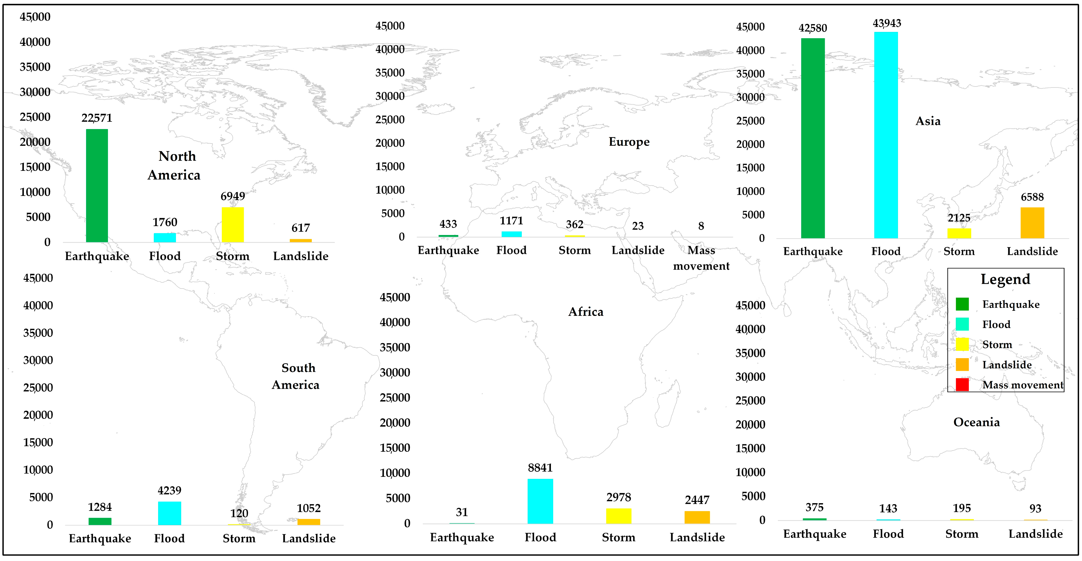
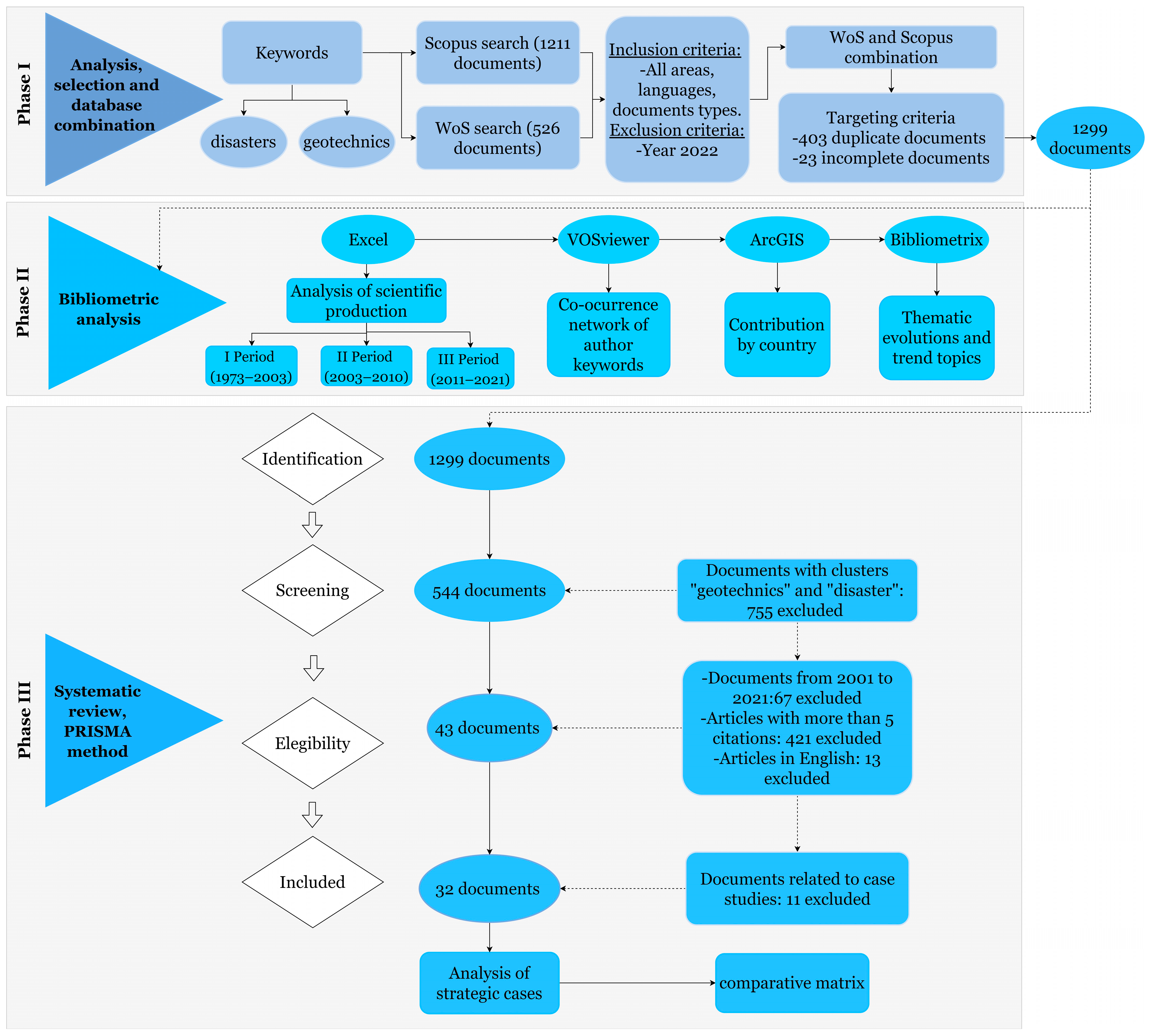
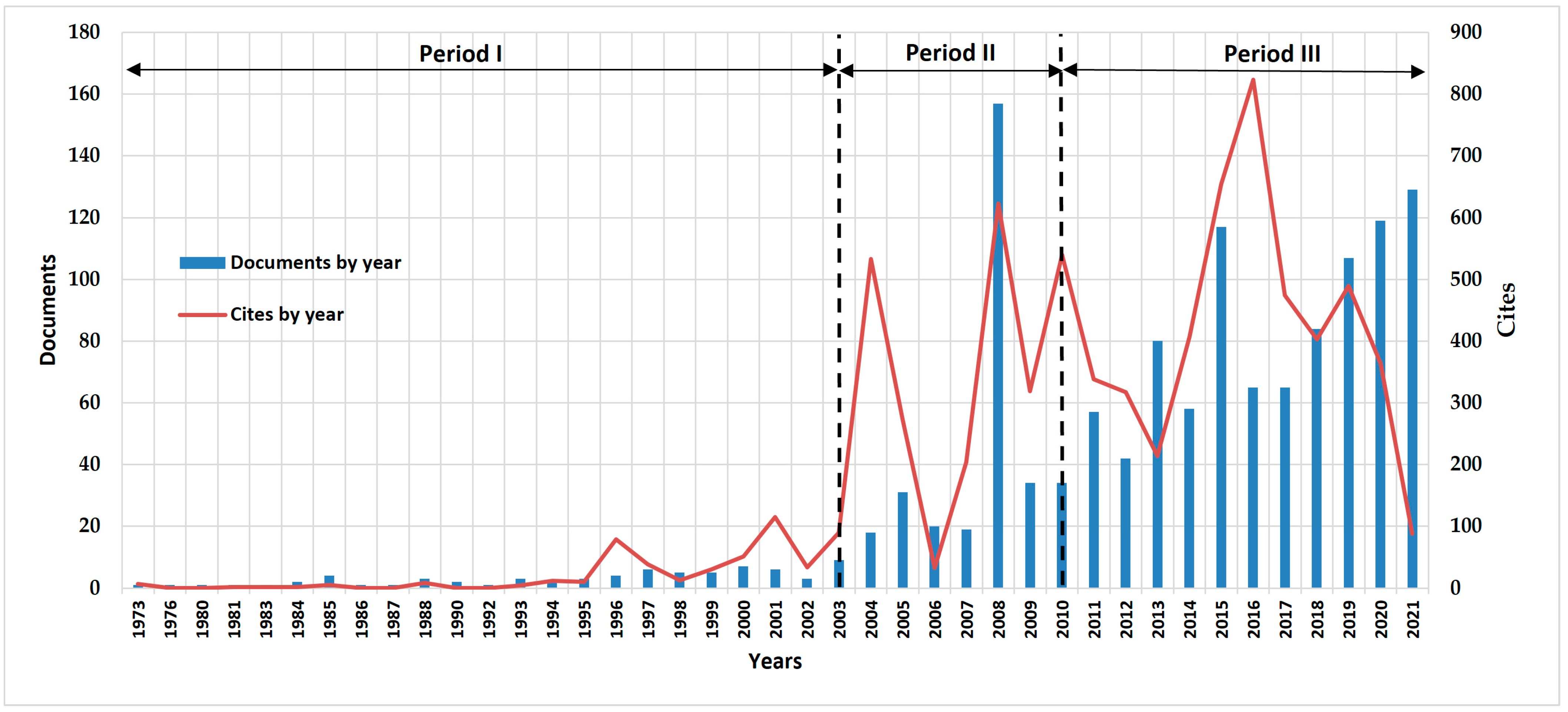
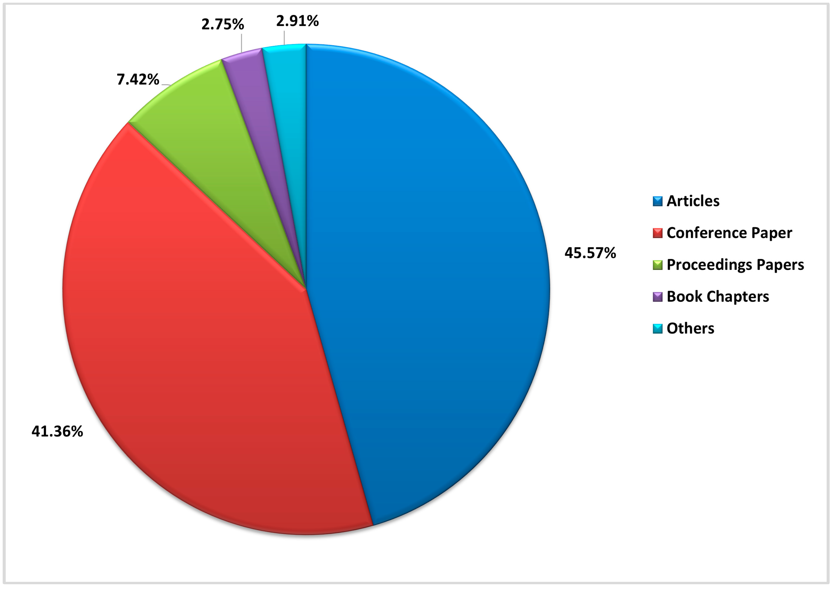
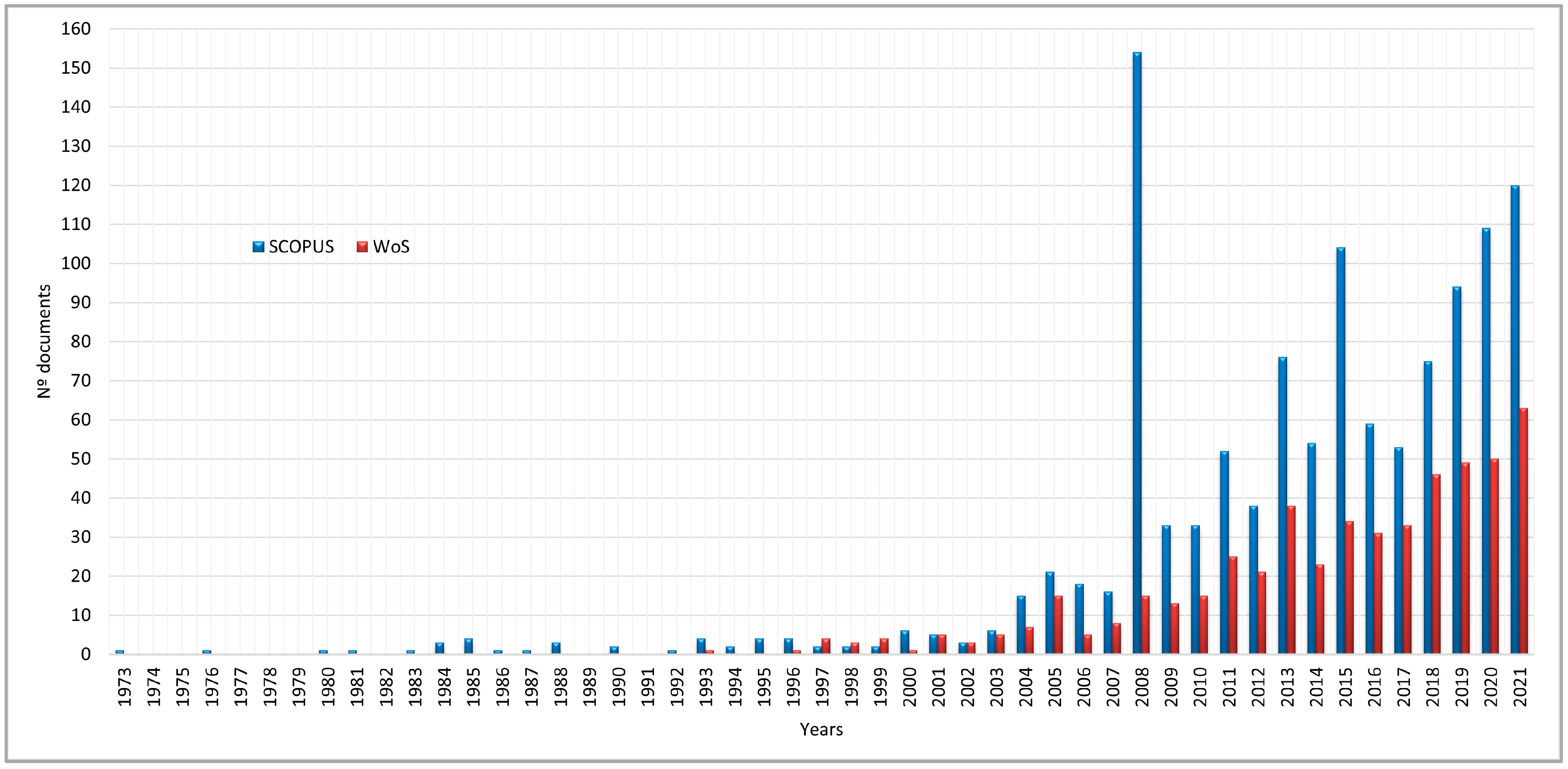
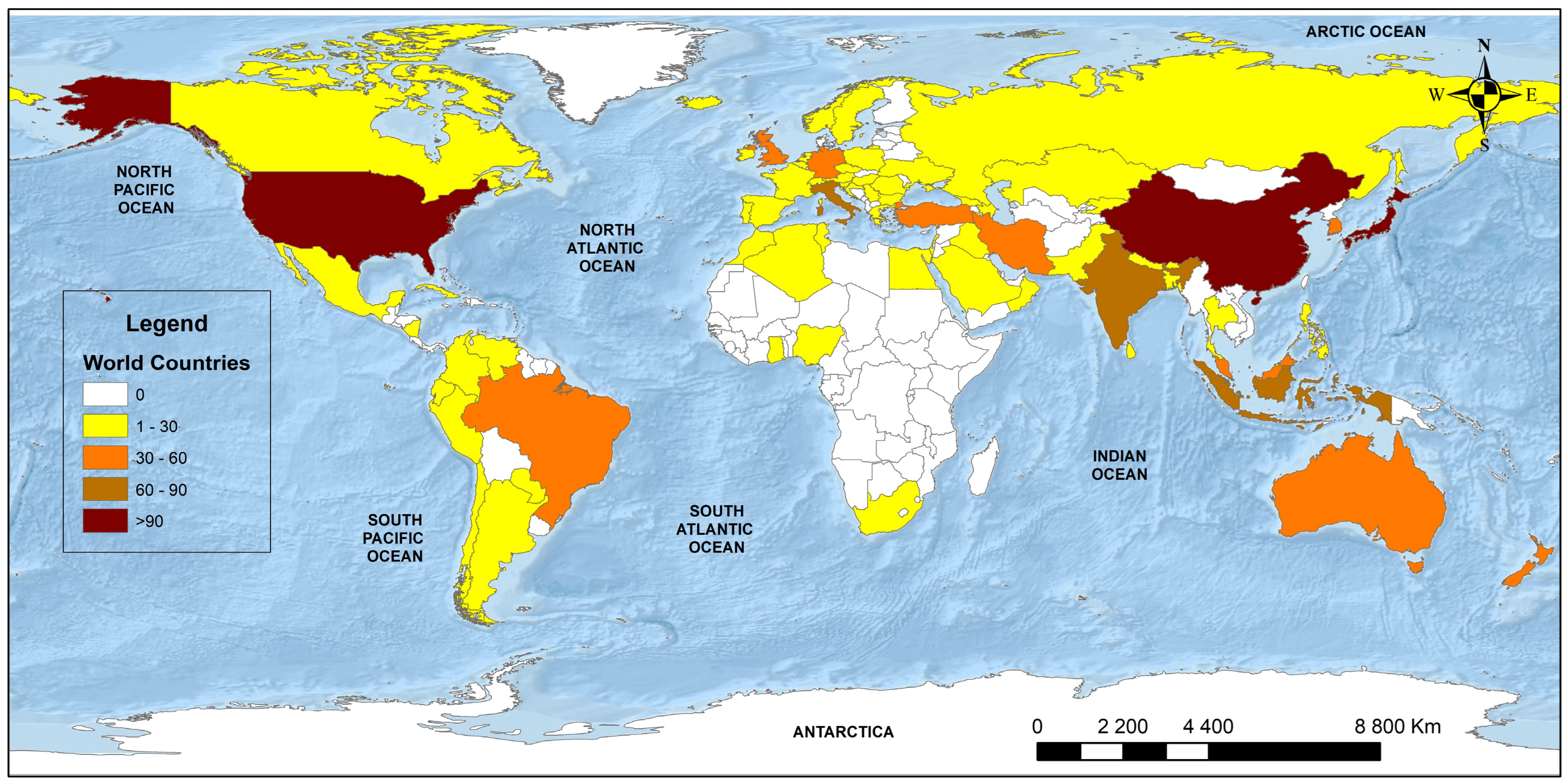
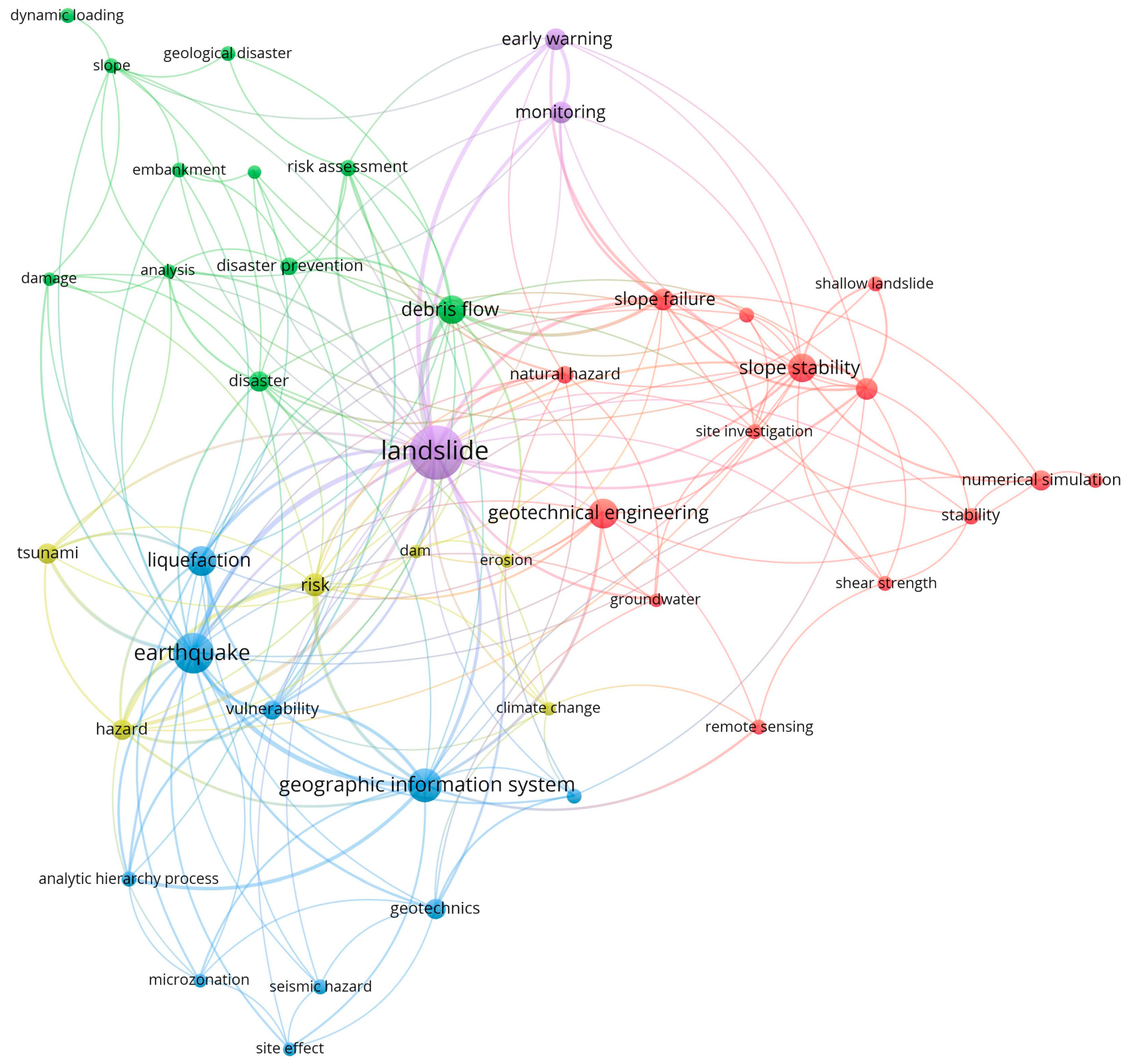
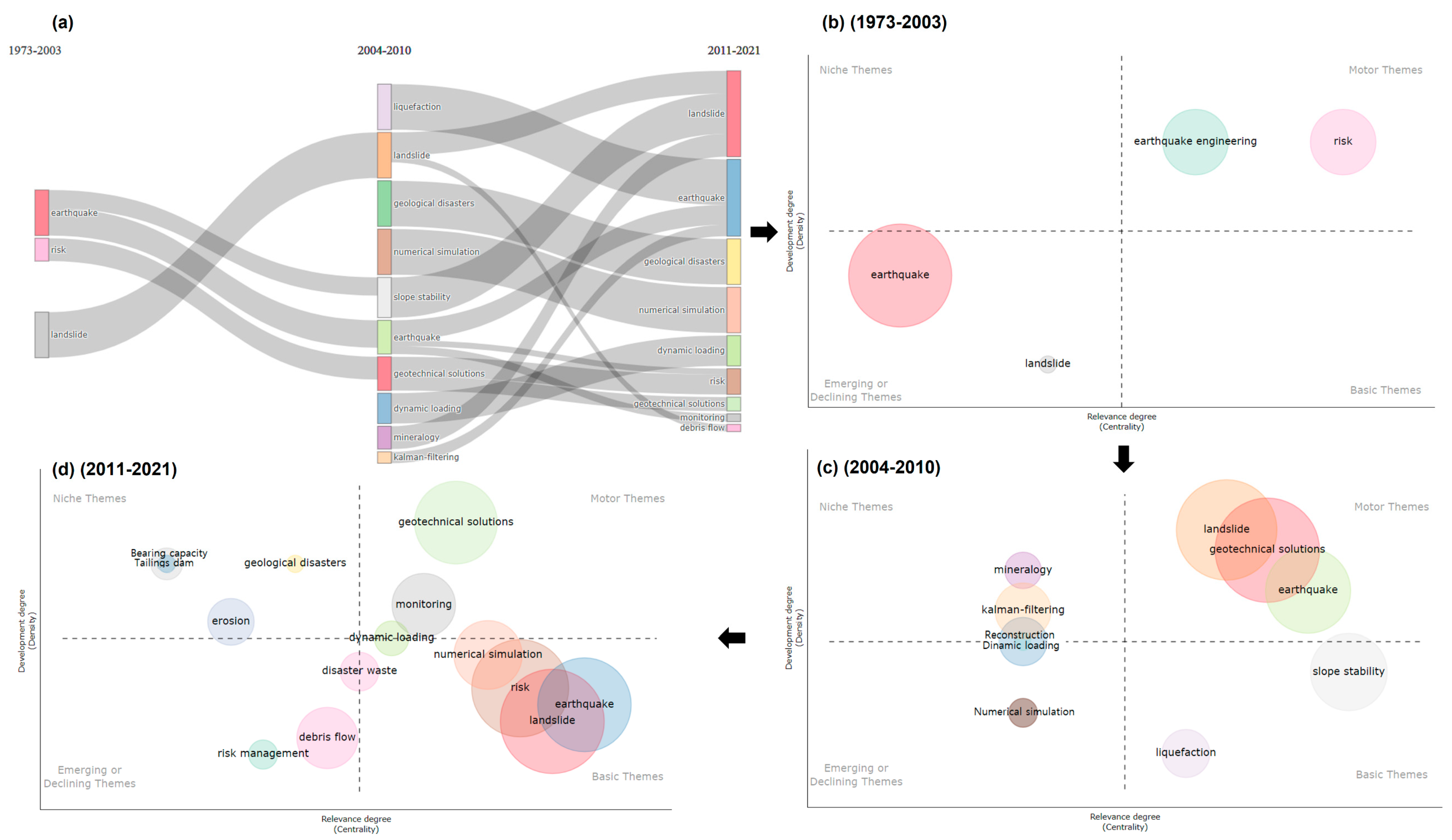
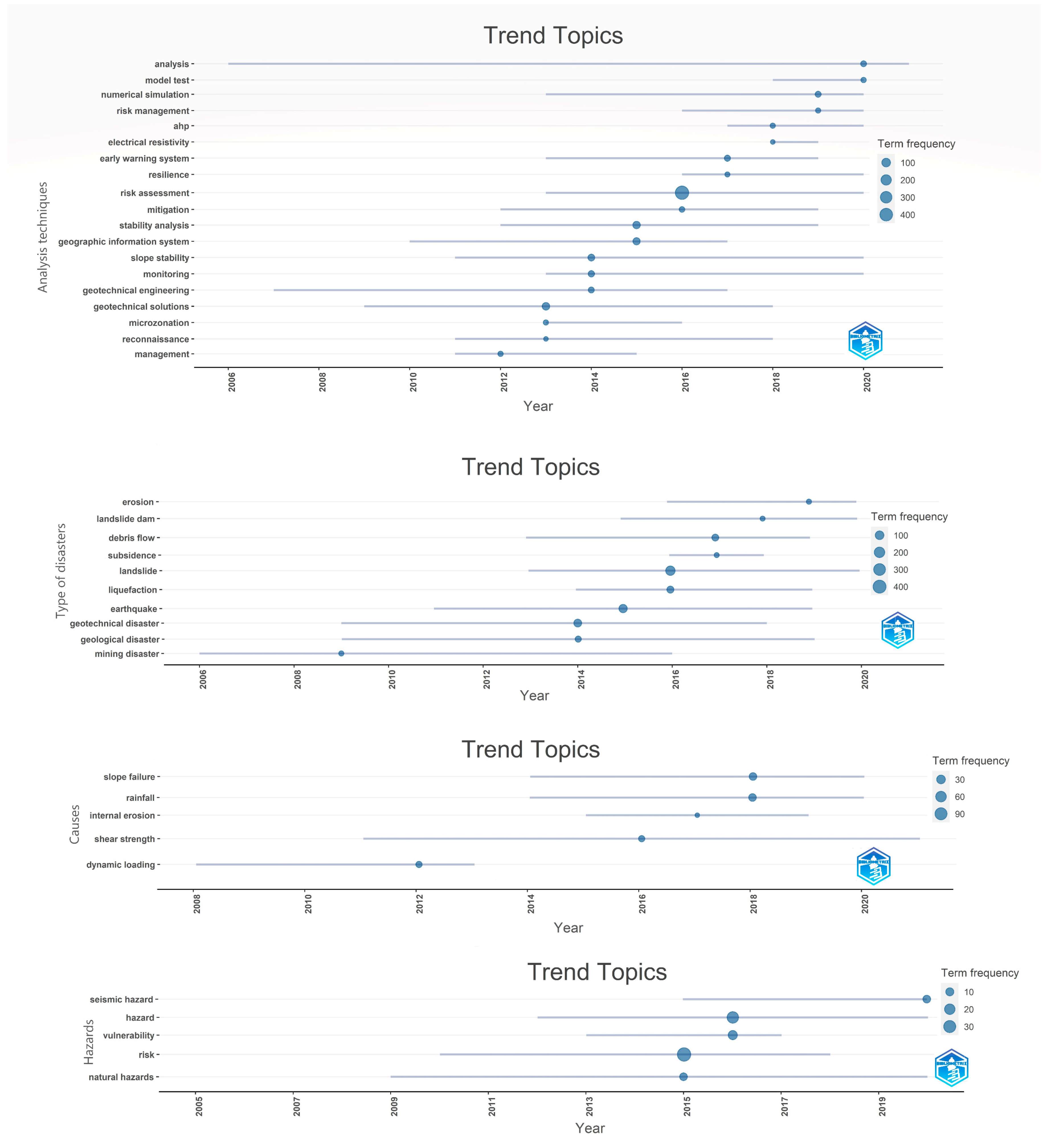
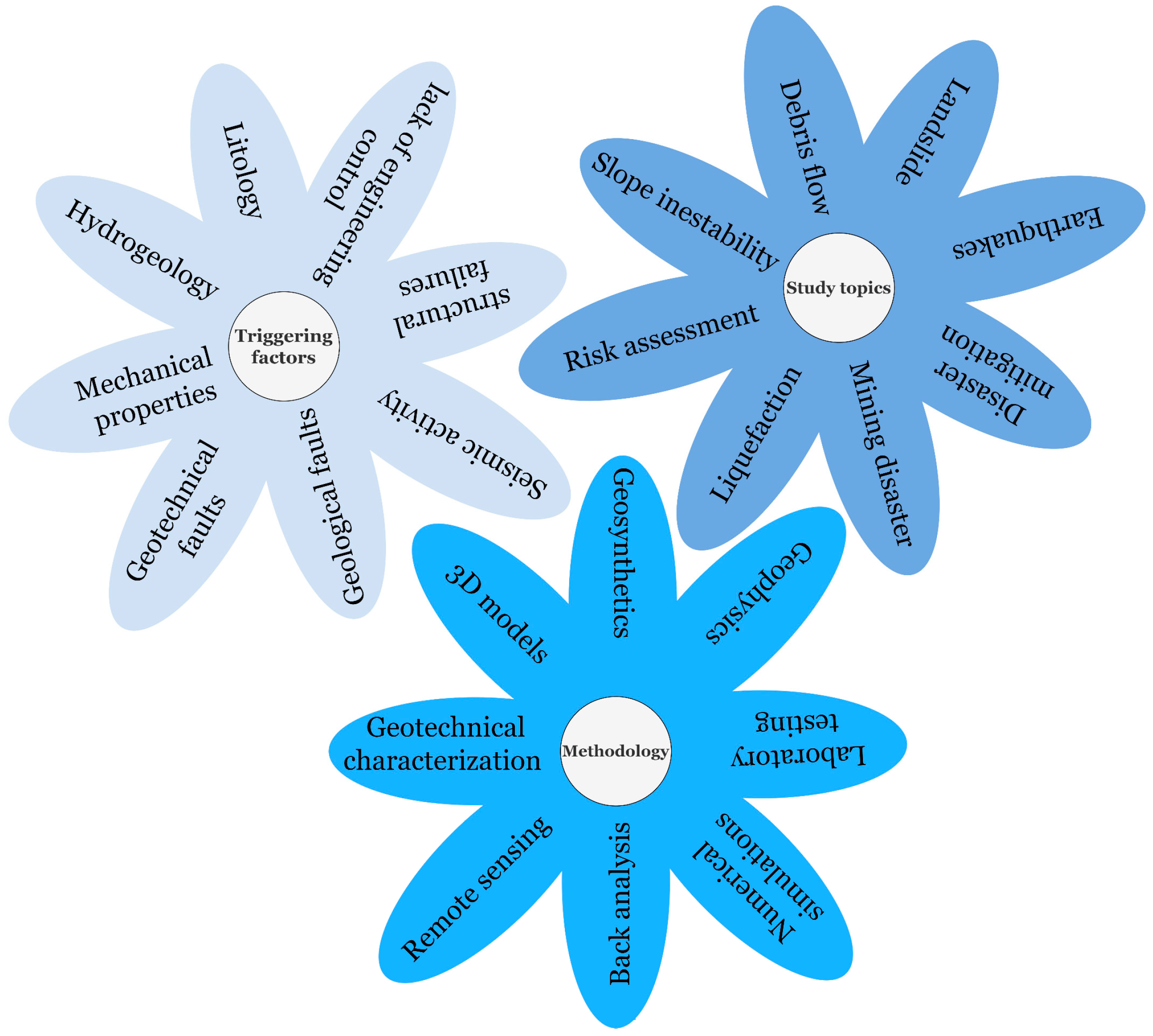
| Causes | Description | Examples |
|---|---|---|
| Inadequate geotechnical investigation | Insufficient research to adequately model conditions on-site. | Nigerian construction industry [14] |
| Wrong parameters | Poor sampling and testing procedures, selection of inappropriate parameters, and underestimation of the variability of soil properties. | Excavation in Singapore [15] |
| Inappropriate analysis model | Critical failure mechanism not recognized. | Grain elevator Transcona, Canada [16] |
| Underestimation of actions | Inaccurate assessment of the magnitude, distribution, or combination of actions (forces or displacements) and change in use of the structure over time. | Kansai International Airport, Japan [17] |
| Unexpected groundwater regimes or changes in humidity content | Changes in groundwater levels can increase structure loads and decrease soil shear strength. | Liquefaction-induced caisson failure: Barcelona Harbor, Spain [18] |
| Periods | Generalities | Study Topics and References |
|---|---|---|
| Period I (1973–2003) | In the first 30 years, there was no significant growth in scientific publications [98], with 53 documents and 264 citations. | Geotechnical investigations in mining waste lagoons [99], dumps [100], groundwater [101], sinkholes [102], waste management [103,104], debris flows [105], and shear wave velocity as a parameter in the field of geotechnical earthquake engineering [106], damage linked to geotechnical phenomena in earthquakes [107,108,109], landslides [110,111], soil liquefaction [112], geotechnical problems in slope stability [108], seismic microzonation [113], geotechnical characteristics of volcanic ash soils [112], and automatic monitoring of slope deformations using geotechnical instruments [114,115]. |
| Period II (2003–2010) | There were 329 documents with 2765 citations, with specific growth peaks in 2005 and 2008, which coincides with the catastrophes that caused thousands of fatalities, such as the tsunami in Indonesia caused by the earthquake in the Indian Ocean (2004) and cyclone Nargis in Burma (Myanmar) (2008). | Seismological/geotechnical aspects of earthquakes [116,117,118], seismic wave velocity measurements [119,120], slope failure disasters [121,122], seismic behavior of geotechnical structures [123,124], realistic numerical simulations [125,126], seismic triggering of landslides [127], geotechnical failure of mining structures [128,129], landslide faults [130,131,132], prevention and monitoring of deformations [133,134], land subsidence [135], surrounding rock instability [136,137], rock bursts [138], slope instability [133,139,140], soft soils [139,141,142], geotechnical engineering problems in water resources projects [143,144], liquefaction susceptibility [145,146], dynamic shear modulus [147], geotechnical analysis of dams [148,149], settlements [150], and embankments [151]. |
| Period III (2011–2021) | It had the most significant number of published documents (917) and included the most cited year (2016). | Studies of geological and geotechnical parameters related to natural hazard susceptibility [152], earthquake damage assessment using remote sensing [153,154], methodologies applied to disaster mitigation and monitoring [10,155,156,157], geotechnical investigations of earthquakes [158,159,160], post-disaster road reconstruction [27,161,162], slope stability [163,164,165], numerical simulations [166,167], mining activities [168,169,170], soft soils [171,172], landslides [173,174,175], dikes [176], dams [177,178,179], study of the geomechanical parameters of materials [180,181,182], soil liquefaction [183,184,185], seismic microzoning [186,187,188], permafrost hazard [189], damage to geotechnical structures due to tsunamis [12], sediment consolidation [190], soil improvement [191], and investigations in coastal areas [192], floods [193,194], and subsidence [195,196]. |
| Disasters | Keywords | Applied Methodology and References |
|---|---|---|
| Geological hazards: soil erosion, soil freeze, coastal area, disaster waste | Avalanche, landslide, rockfall, tsunami, soil erosion, expansive subgrade soils, coastal zones, geotechnical engineering, hazard, shear flow, soil freeze, pavement structure, freeze damage, freezing front, shear waves, spectrum analysis, surface waves, wave propagation, frost effects, disaster waste and developing countries. | Geological survey [118], treating measures in expansive soil subgrade [139], spectral analysis of surface waves (SASW), probabilistic seismic hazard analysis (PSHA) and EZ-FRISK software [134], expanded polystyrene (EPS) geofoam [297], primary data collection and analysis [298]. |
| Earthquakes | Earthquake, geotechnical engineering, soft soil, damage investigation, mountain tunnels, ground faults, landslides and slope instability, disaster mitigation, ductility, stability, three-dimensional geosynthetics, UAV and wireless sensor networks (WSN). | Field visit and information gathering [116], systematic investigation [118], structural damage observation and analysis [299], earthquake early warning system (EEWS), triaxial MEMS accelerometers, down-hole (DH), multichannel analysis of surface waves (MASW) [300], tire-derived three-dimensional geosynthetics [242], UAV, drones, WSN, and LiDAR [25]. |
| Liquefaction | Liquefaction, seismic hazards, engineering geology, geotechnics, surface geology, pond ash, sand, evaluation, soil, earthquake, numerical modelling, centrifugal testing, geotechnical engineering, earthquakes (natural disasters), and dike stability. | Liquefaction susceptibility mapping [145], triaxial test setup with a little modification to the triaxial cell [202], injecting air bubbles into sandy ground [301], rammed granular piles (RGP) [302], systematic research, MASW, piezometers [303], high-resolution satellite images, electromagnetic and electrical resistivity methods [251]. |
| Inappropriate analysis model | Numerical analysis, bamboo piles, soil reinforcement, expanded polystyrene (EPS), disaster prevention engineering, silty soil, properties’ improvement, carbon fiber, direct shear test, mechanical properties, displacement, microstructure, slopes, construction, and geotechnics. | Bamboo pile–mattress system [304], EPS geofoam [305], analysis of soil improvement methodologies [191], carbon fiber, and nanosilica [306]. |
| Landslides | Landslides, impact factor, void ratio, deviator stress, triaxial test, residual test, residual strength, triaxial compression, debris flow, dissipation structures, drainage channel, developing countries, disaster engineering, geotechnical engineering, land subsidence, long-term monitoring, differential interferometric synthetic aperture radar (DInSAR), hyperbolic method, material point method (MPM), runout, discontinuous deformation analysis (DDA), and open multiprocessing (OpenMP). | Triaxial test [307], systematic review [308], Chasm software (combined hydrology and stability model) [309], drainage channel with an energy dissipation structure [310], DInSAR, GPS, Envisat—synthetic aperture radar (ASAR), advanced land-observing satellite (ALOS)–PALSAR and Sentinel-1 SAR data [311], MPM [312], DDA and OpenMP [313]. |
| Mining disasters | Mine, geomechanics, failure, hydrogeology, underground workspace safety, floor water inrush, strata failure depth, combined techniques, strip mining, caving zone backfilling, dehydration, earth pressure, soil/structure interaction, stress analysis, theoretical analysis, tailings, disasters, and geotechnics. | High-pressure direct shear apparatus and triaxial servo test system [314], geological and geotechnical investigations [315], piezometers, upstream construction method, early warning systems, in situ testing, standard penetration test (SPT), cone penetration testing and vane shear tests [316], strip mining and caving zone backfilling technique [317]. |
Publisher’s Note: MDPI stays neutral with regard to jurisdictional claims in published maps and institutional affiliations. |
© 2022 by the authors. Licensee MDPI, Basel, Switzerland. This article is an open access article distributed under the terms and conditions of the Creative Commons Attribution (CC BY) license (https://creativecommons.org/licenses/by/4.0/).
Share and Cite
Solórzano, J.; Morante-Carballo, F.; Montalván-Burbano, N.; Briones-Bitar, J.; Carrión-Mero, P. A Systematic Review of the Relationship between Geotechnics and Disasters. Sustainability 2022, 14, 12835. https://doi.org/10.3390/su141912835
Solórzano J, Morante-Carballo F, Montalván-Burbano N, Briones-Bitar J, Carrión-Mero P. A Systematic Review of the Relationship between Geotechnics and Disasters. Sustainability. 2022; 14(19):12835. https://doi.org/10.3390/su141912835
Chicago/Turabian StyleSolórzano, Joselyne, Fernando Morante-Carballo, Néstor Montalván-Burbano, Josué Briones-Bitar, and Paúl Carrión-Mero. 2022. "A Systematic Review of the Relationship between Geotechnics and Disasters" Sustainability 14, no. 19: 12835. https://doi.org/10.3390/su141912835
APA StyleSolórzano, J., Morante-Carballo, F., Montalván-Burbano, N., Briones-Bitar, J., & Carrión-Mero, P. (2022). A Systematic Review of the Relationship between Geotechnics and Disasters. Sustainability, 14(19), 12835. https://doi.org/10.3390/su141912835