Analysis of Ecological Environmental Quality Change in the Yellow River Basin Using the Remote-Sensing-Based Ecological Index
Abstract
:1. Introduction
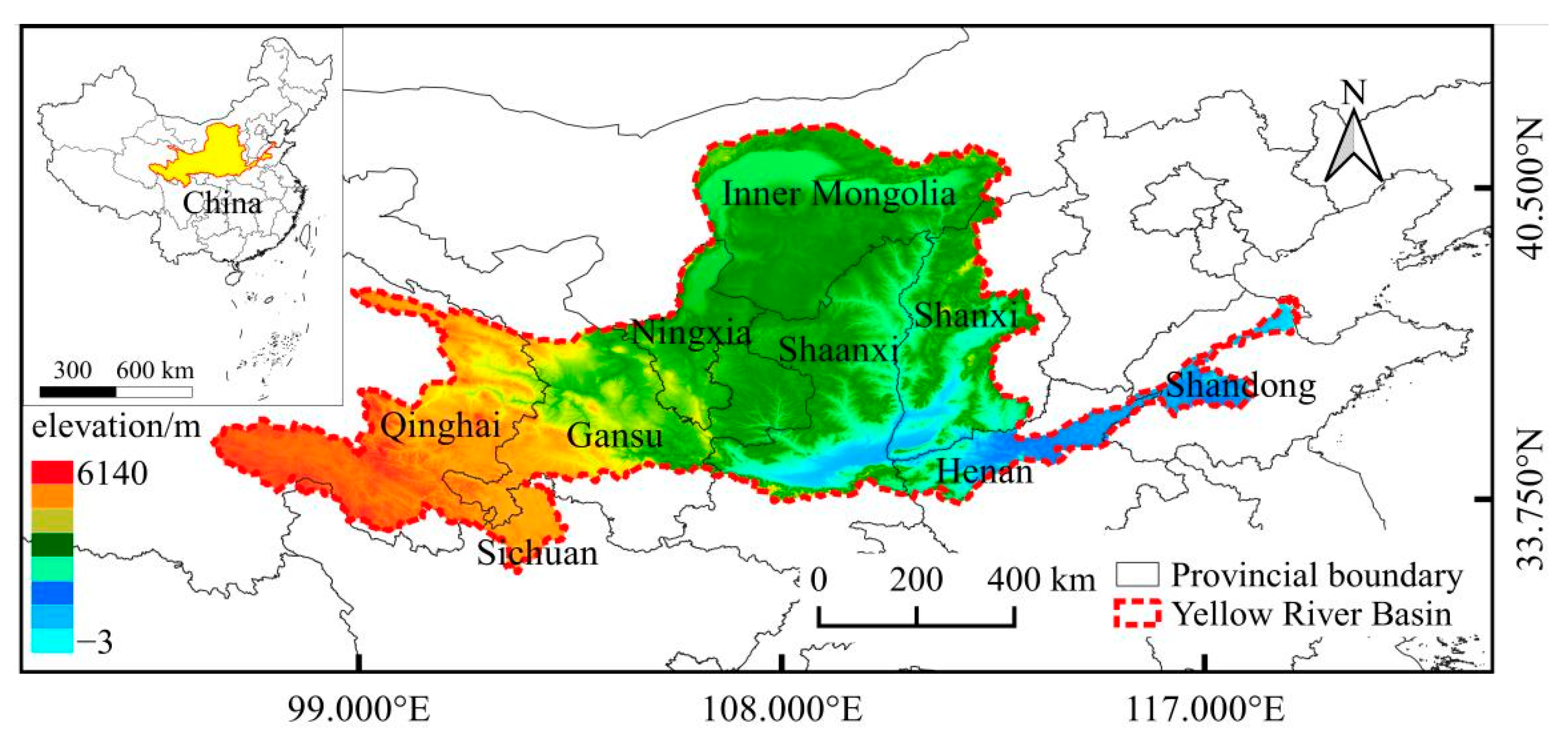
2. Study Area
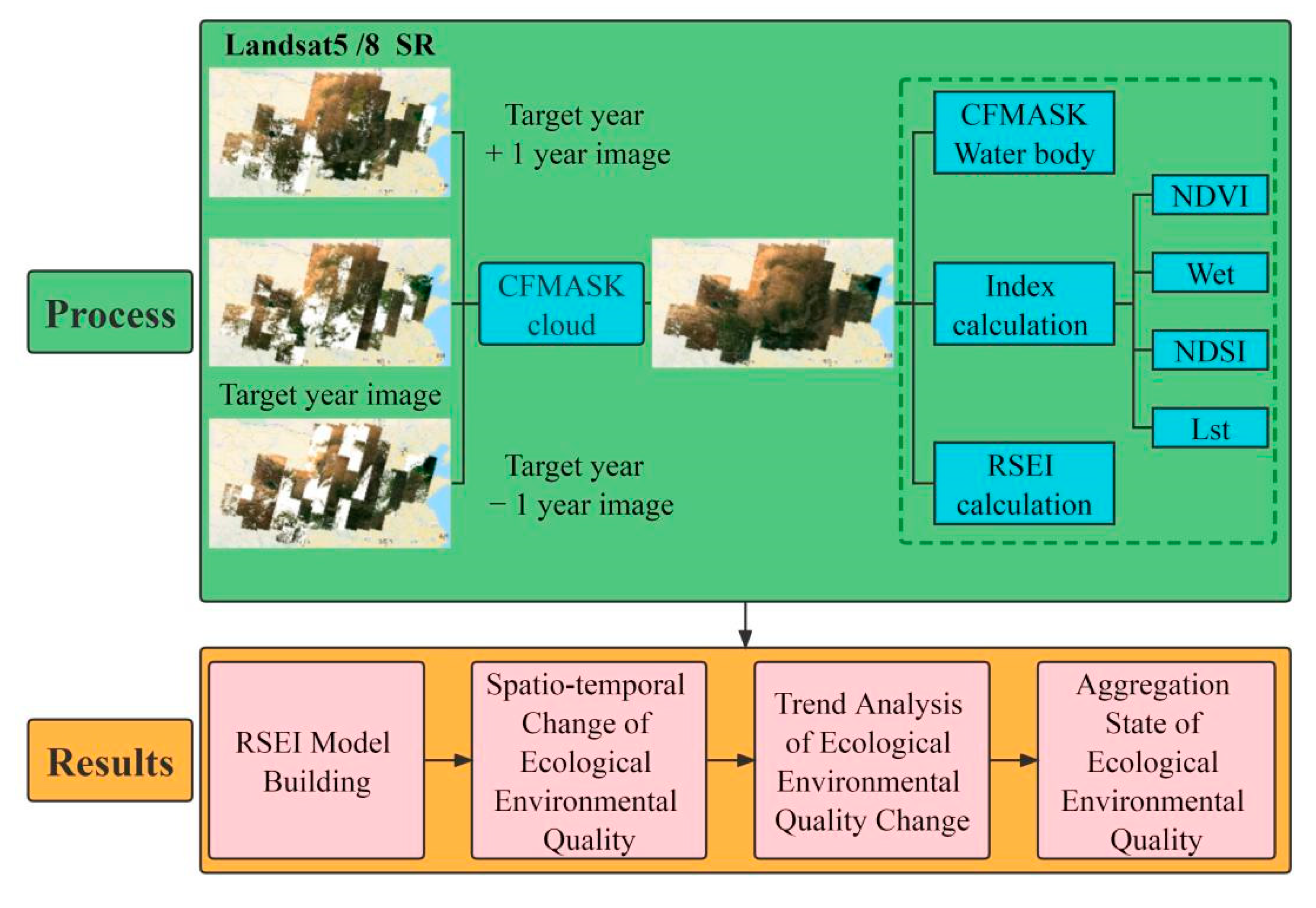
3. Materials and Methods
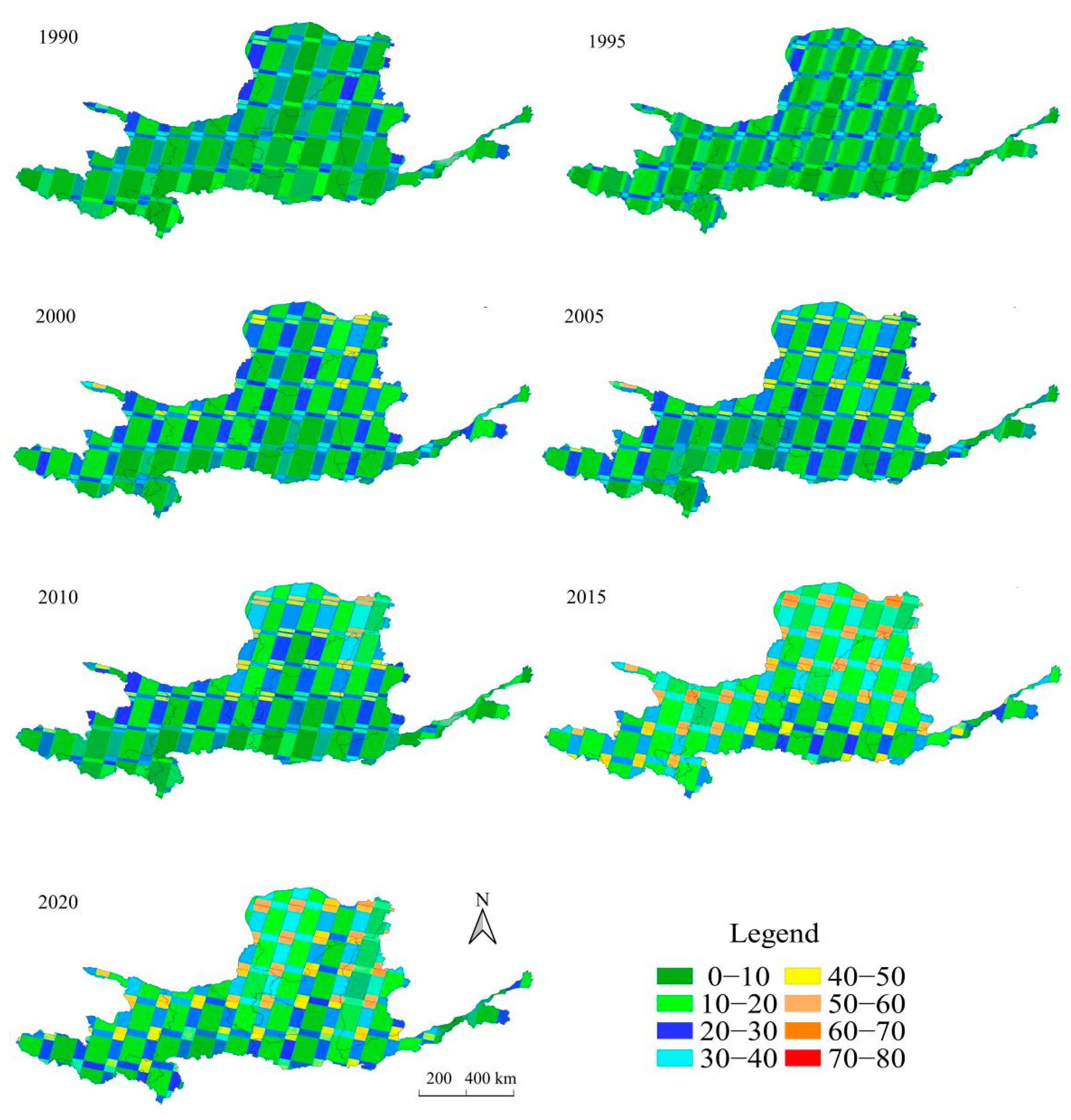
3.1. Data and Preconditioning
3.2. Calculation of the Remote-Sensing-Based Ecological Index (RSEI)
4. Results
4.1. RSEI Model Building
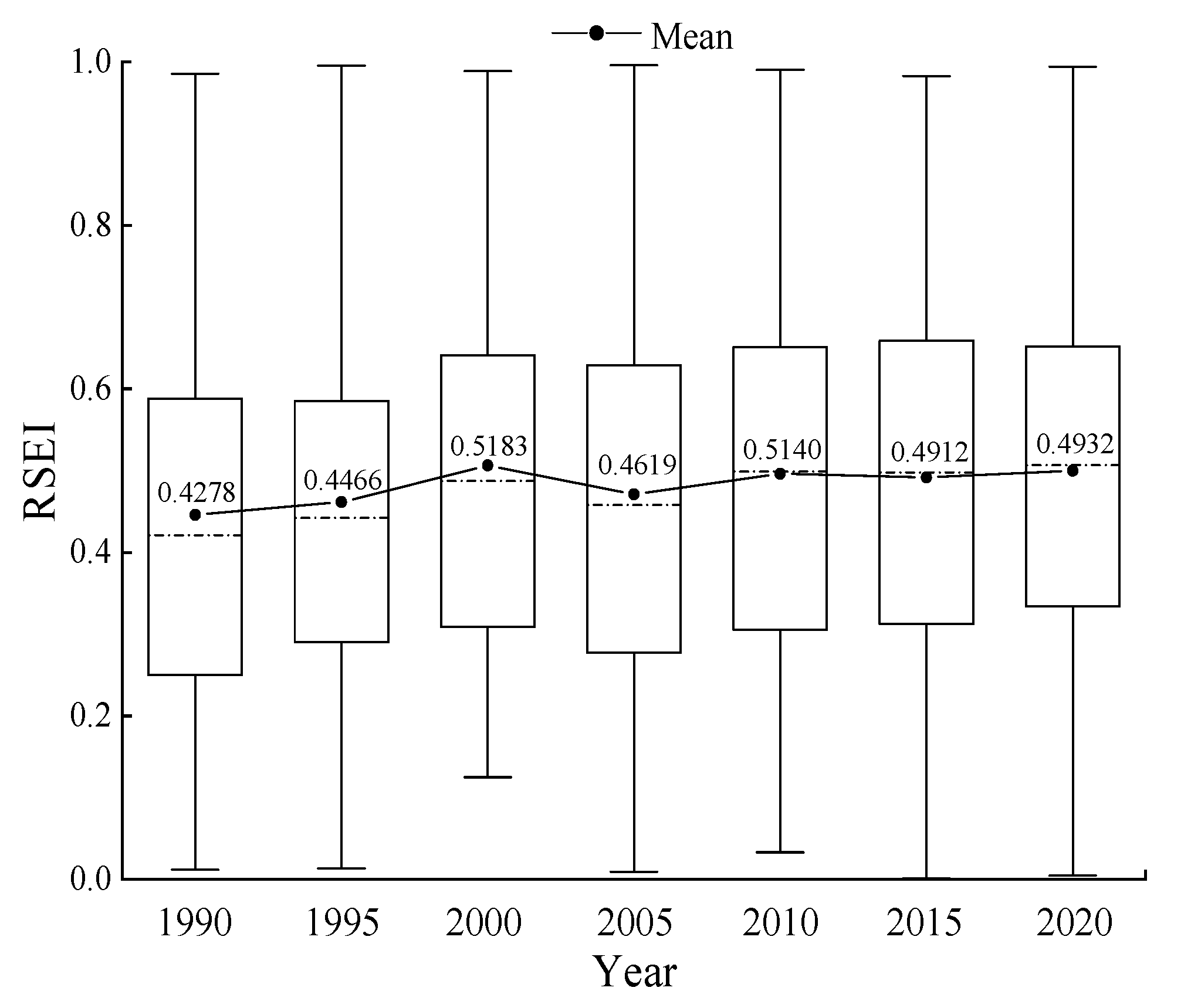
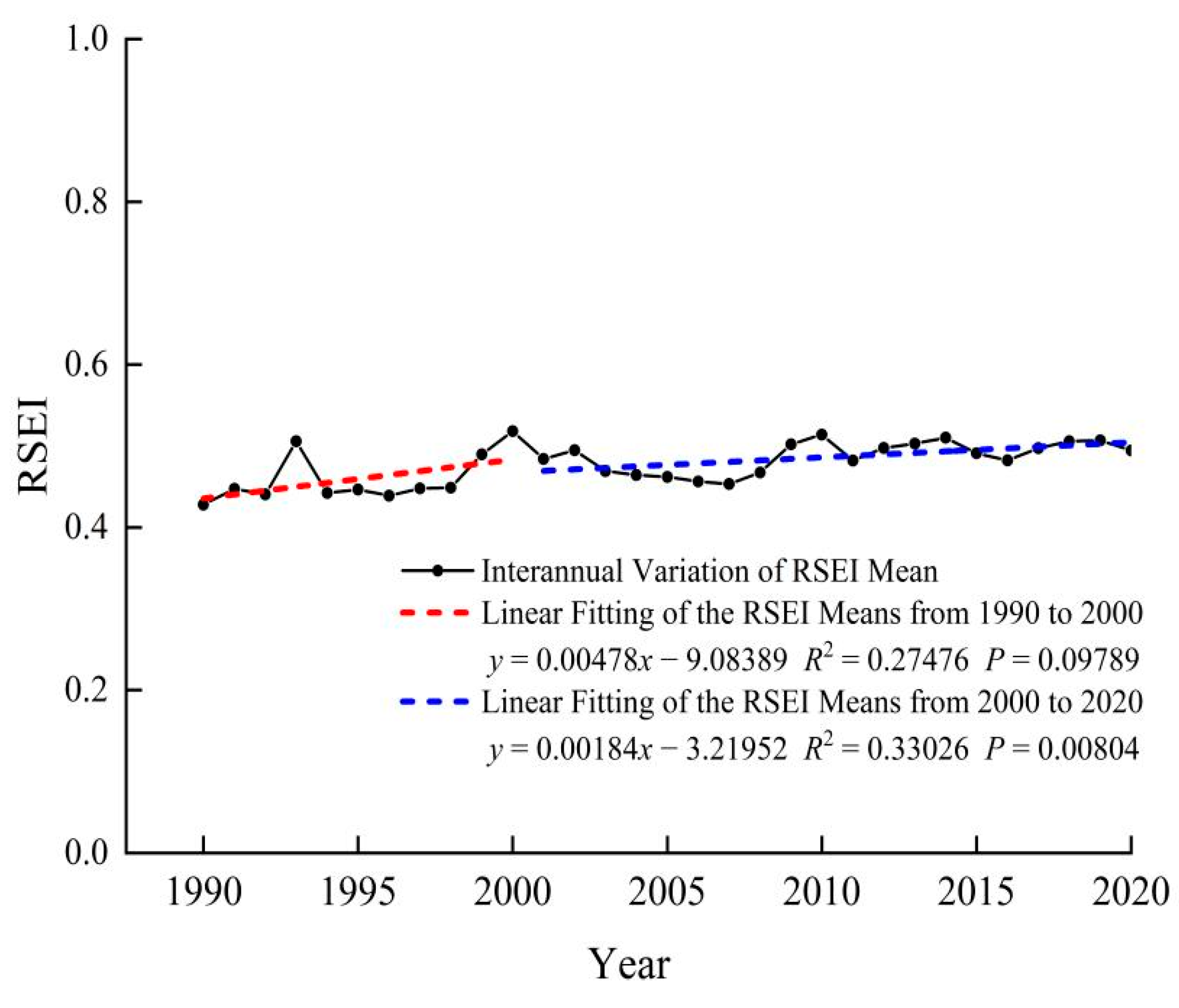
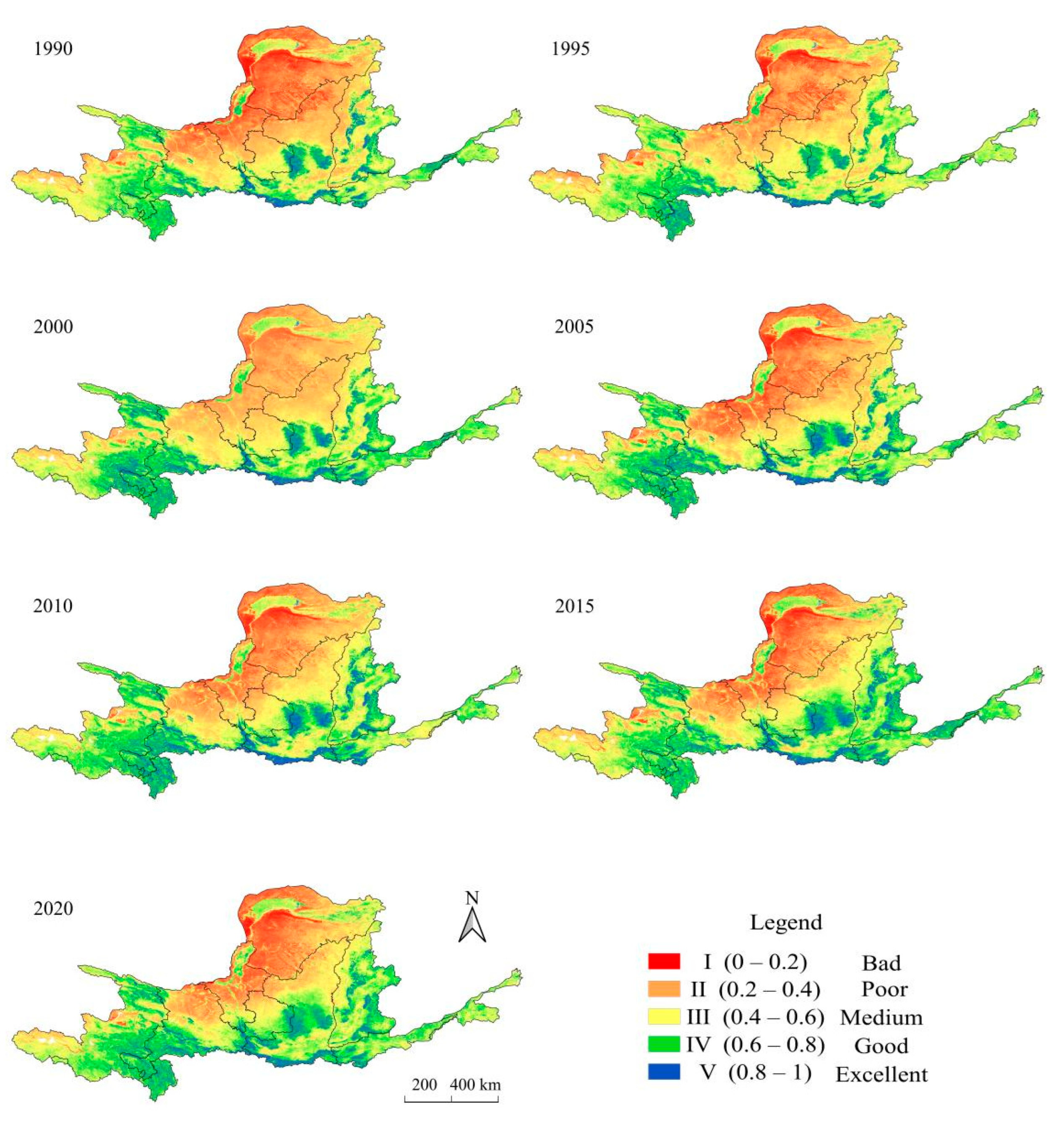
4.2. Spatiotemporal Changes of the Ecological Environmental Quality
4.3. Trend Analysis of the Ecological Environmental Quality Change
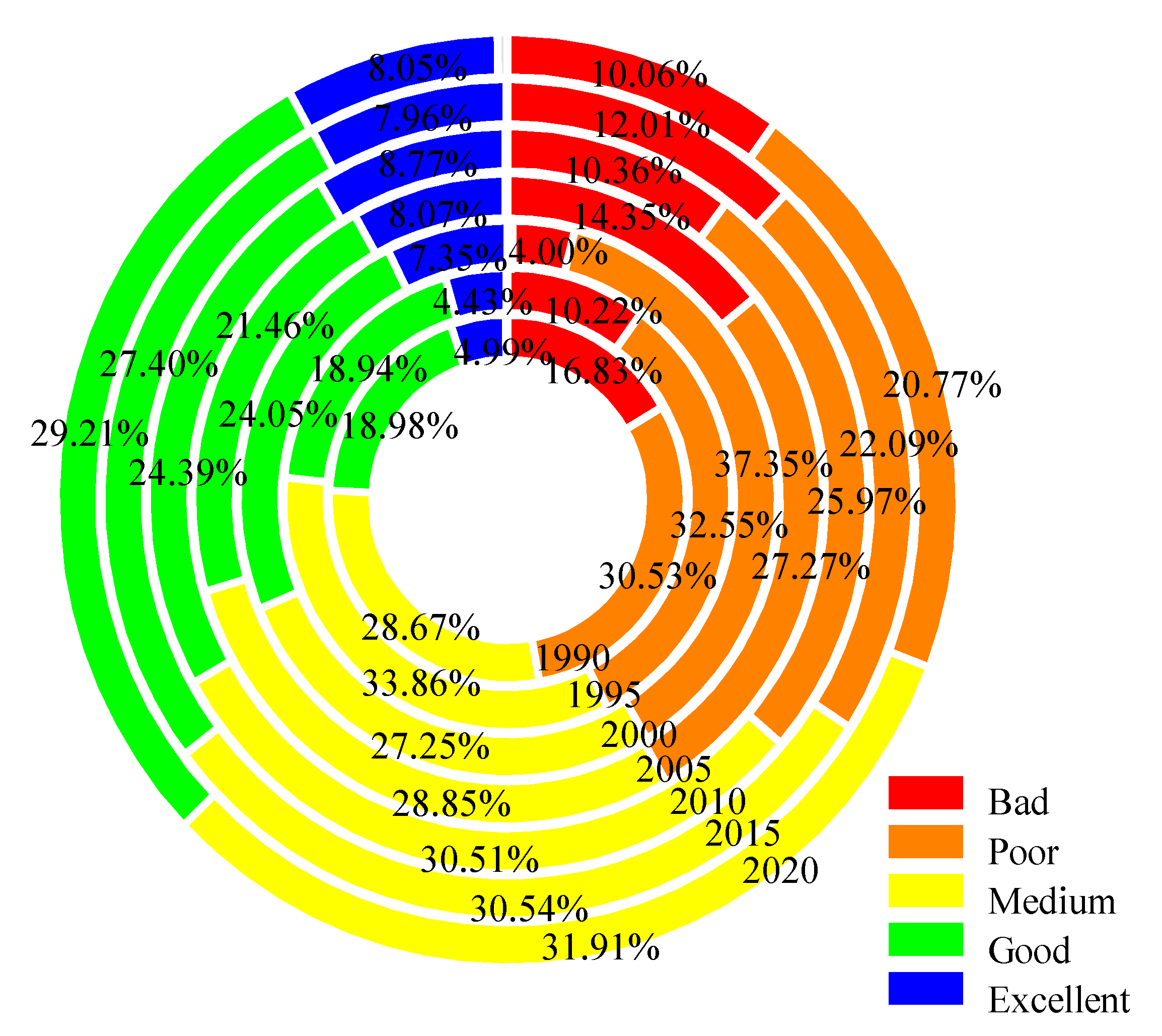
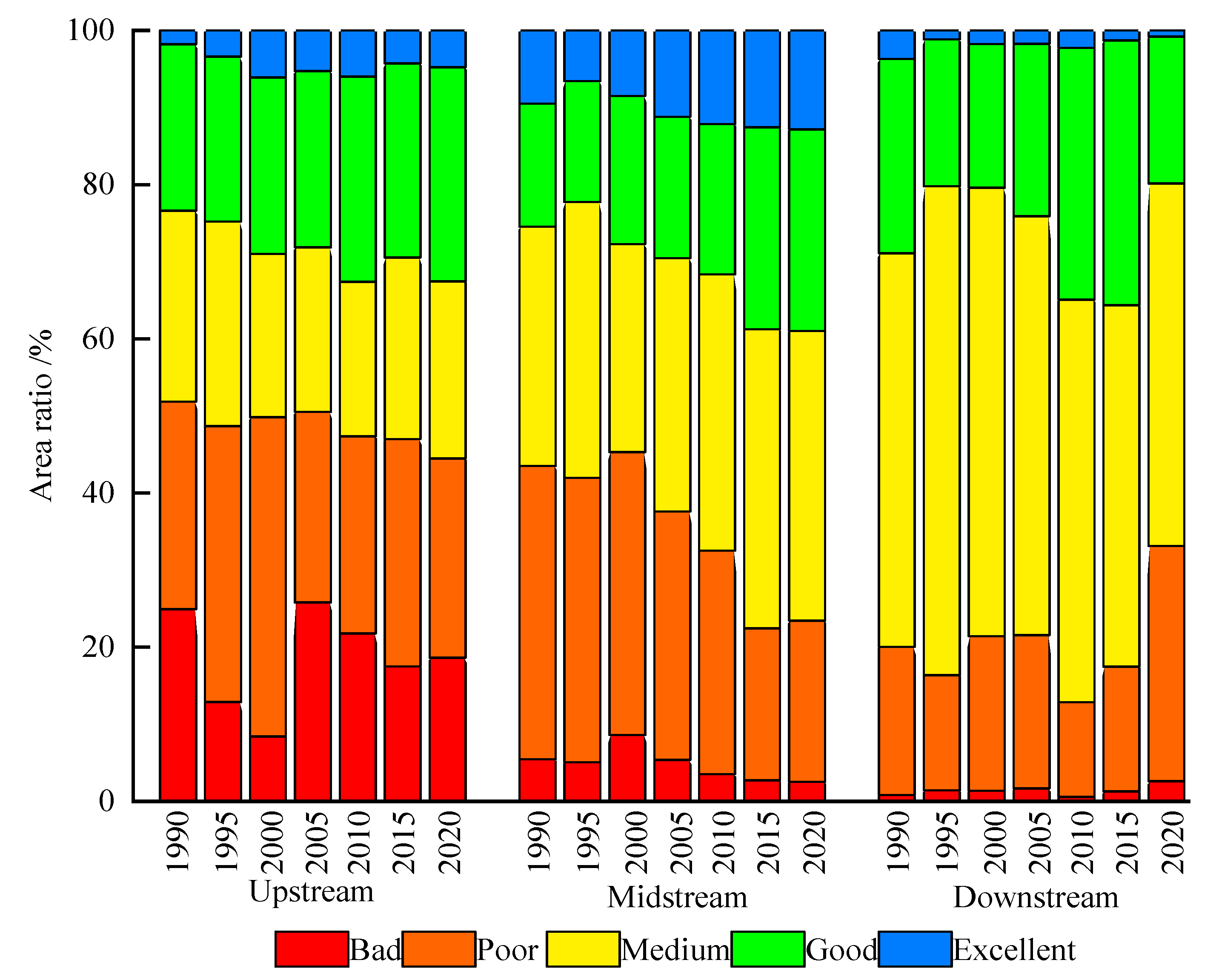
4.3.1. Change of the Ecological Environmental Quality Levels
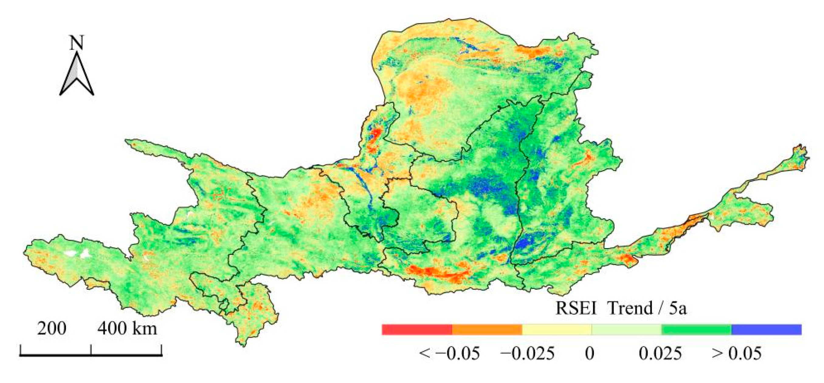
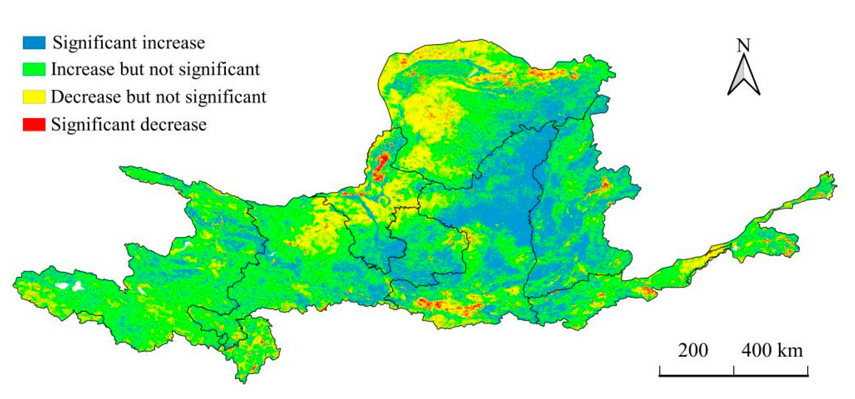
4.3.2. Change Trend and Significance of the Ecological Environmental Quality
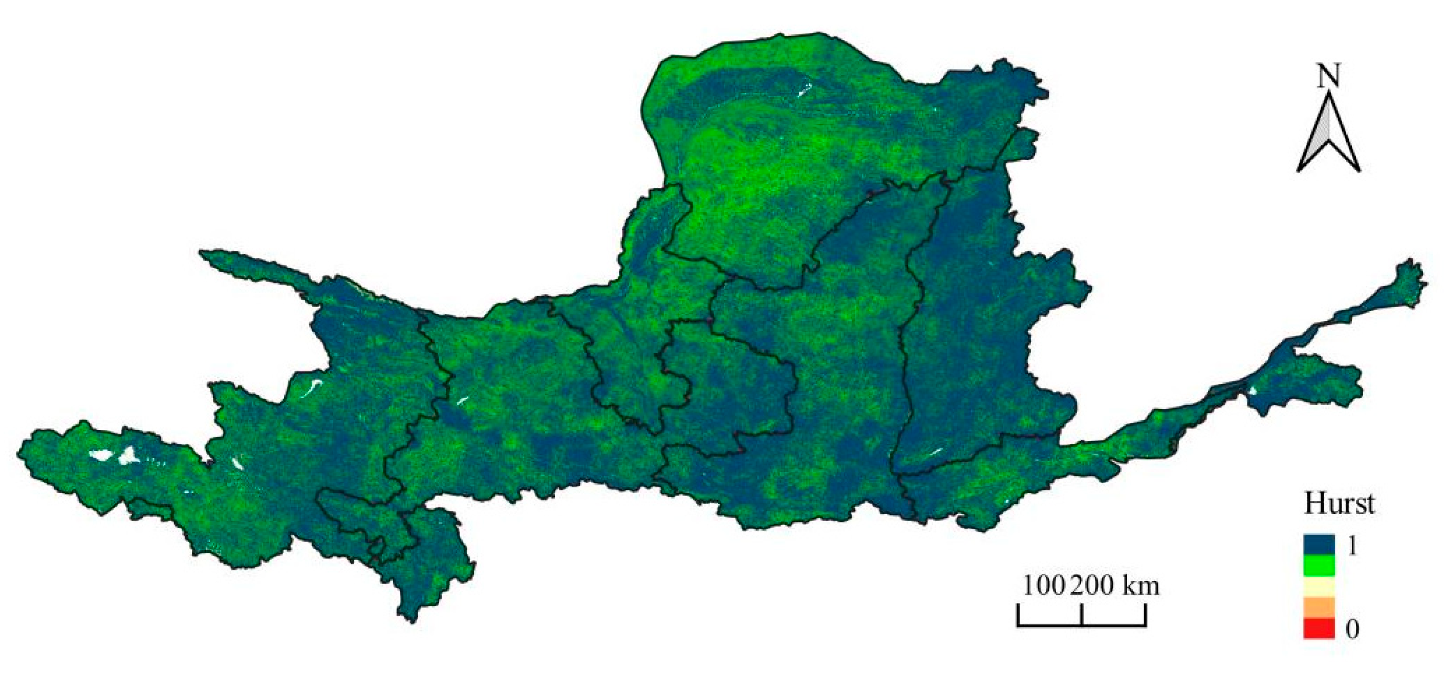
4.3.3. Sustainability Analysis
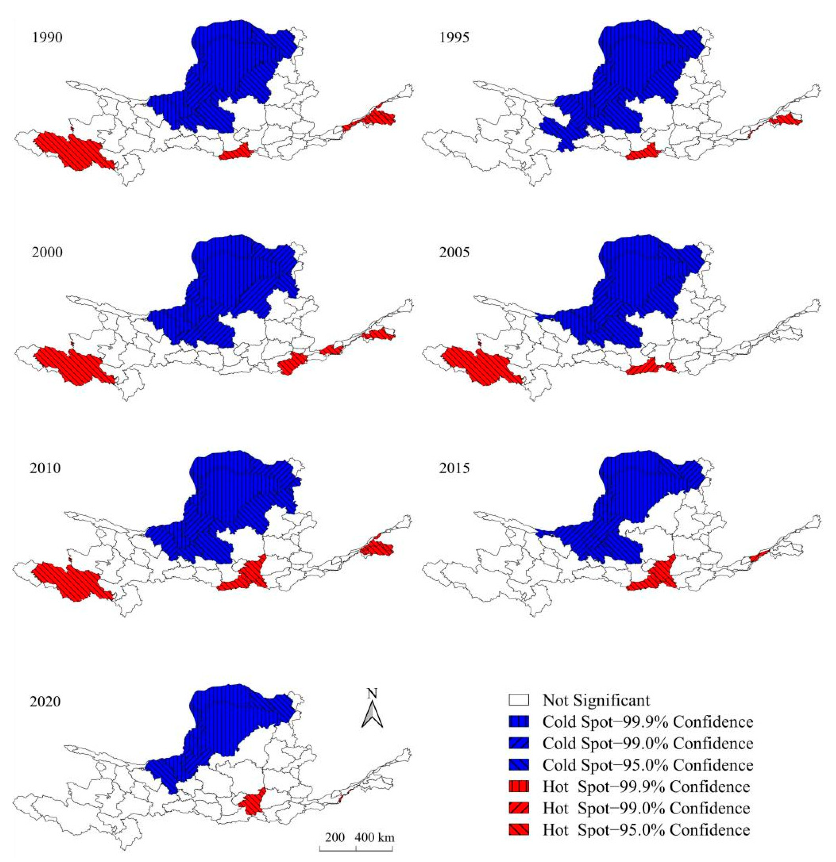
4.4. Aggregation State of the Ecological Environmental Quality
5. Discussion
5.1. Advantages of the RSEI Model
5.2. Advantages of Constructing the RSEI Model Based on the GEE Platform
5.3. Reasons for the Spatiotemporal Change in Ecological Environmental Quality
6. Conclusions
Author Contributions
Funding
Institutional Review Board Statement
Informed Consent Statement
Data Availability Statement
Conflicts of Interest
References
- Xi, J.P. Speech at the Symposium on Ecological Protection and High-quality Development in the Yellow River Basin. Struggle 2019, 20, 4–10. [Google Scholar]
- Han, P.; Wang, Y.X.; Li, D.F. Spatial and Temporal Variations of Baseflow and Its Responses to Soil and Water Conservation in Hekouzhen-Longmen Section in the Middle Reaches of the Yellow River. J. Basic Sci. Eng. 2020, 28, 505–521. [Google Scholar]
- Zhao, A.Z.; Liu, X.F.; Zhu, X.F.; Pan, Y.Z.; Chen, S.C. Spatiotemporal analyses and associated driving forces of vegetation coverage change in the Loess Plateau. China Environ. Sci. 2016, 36, 1568–1578. [Google Scholar]
- Hung, J.T.; Cao, Y.P.; Qin, F. Analysis of Eco-environment Quality Based on Land Use/Cover Change in the Yellow River Basin. J. Henan Univ. Nat. Sci. 2020, 50, 127–138. [Google Scholar]
- Fang, C.L. Basic rules and key paths for high-quality development of the new urbanization in China. Geogr. Res. 2019, 38, 13–22. [Google Scholar]
- Wang, Y.; Zhao, Y.H.; Wu, J.S. Dynamic monitoring of long time series of ecological quality in urban agglomerations using Google Earth Engine cloud computing: A case study of the Guangdong-Hong Kong-Macao Greater Bay Area, China. Acta. Ecol. Sin. 2020, 40, 8461–8473. [Google Scholar]
- Mateo, G.G.; Gómez, C.L.; Amorós, J.; Muñoz, J.; Camps, G. Multitemporal cloud masking in the Google earth engine. Remote Sens. 2018, 10, 1079. [Google Scholar] [CrossRef]
- Rai, P.K. Forest and land use mapping using Remote Sensing and Geographical Information System: A case study on model system. Environ. Skept. Crit. 2013, 2, 97–107. [Google Scholar]
- Chen, W.; Huang, H.; Tian, Y.C.; Du, Y.Y. Monitoring and Assessment of the Eco-Environment Quality in the Sanjiangyuan Region based on Google Earth Engine. J. Geo-Inf. Sci. 2019, 21, 1382–1391. [Google Scholar]
- Ivits, E.; Buchanan, G.; Olsvig, W.L.; Cherlet, M. European farmland bird distribution explained by remotely sensed phenological indices. Environ. Model. Assess. 2011, 16, 385. [Google Scholar] [CrossRef]
- Coutts, A.M.; Harris, R.J.; Phan, T.; Livesley, S.J.; Williams, N.S.G.; Tapper, N.J. Thermal infrared remote sensing of urban heat: Hotspots, vegetation, and an assessment of techniques for use in urban planning. Remote Sens. Environ. 2016, 186, 637–651. [Google Scholar]
- Guo, W.H.; Wu, L.M.; Zuo, X.Q.; Fang, G. Water body extraction of Huainan city based on TM images. Geotechnical. Investig. 2018, 46, 64–67. [Google Scholar]
- Wang, C.S.; Duan, Y.X.; Zhang, R. Spatial pattern evolution of cities and influencing factors in the historical Yellow River Basing. J. Nat. Resour. 2021, 36, 69–86. [Google Scholar]
- Xu, H.Q. A remote sensing urban ecological index and its application. Acta. Ecol. Sin. 2013, 33, 7853–7862. [Google Scholar]
- Zhu, D.Y.; Chen, T.; Zhen, N.; Niu, R.Q. Monitoring the effects of open-pit mining on the eco-environment using a moving window-based remote sensing ecological index. Environ. Sci. Pollut. Res. 2020, 27, 15716–15728. [Google Scholar]
- Hang, X.; Li, Y.C.; Luo, X.C.; Xu, M.; Han, X.Z. Assessing the ecological quality of Nanjing during its urbanization process by using satellite, meteorological, and socioeconomic data. J. Meteorol. Res. 2020, 34, 280–293. [Google Scholar]
- Yang, J.Y.; Wu, T.; Pan, X.Y.; Du, H.T.; Li, J.L.; Zhang, L.; Men, M.X.; Chen, Y. Ecological quality assessment of Xiongan New Area based on remote sensing ecological index. Chin. J. Appl. Ecol. 2019, 30, 277–284. [Google Scholar]
- Song, H.M.; Xue, L. Dynamic monitoring and analysis of ecological environment in Weinan City, Northwest China based on RSEI model. Chin. J. Appl. Ecol. 2016, 27, 3913–3919. [Google Scholar]
- He, Z.; He, J.P. Remote Sensing on Spatio-temporal Evolution of V egetation Cover in the Yellow River Basin during 1982–2013. Trans. Chin. Soc. Agr. Mach. 2017, 48, 179–185. [Google Scholar]
- Guo, B.B.; Fang, Y.L.; Jin, X.B.; Zhou, Y.K. Monitoring the effects of land consolidation on the ecological environmental quality based on remote sensing: A case study of Chaohu Lake Basin, China. Land Use Policy 2020, 95, 104569. [Google Scholar]
- Shan, W.; Jin, X.B.; Ren, J.; Wang, Y.C.; Xu, Z.G.; Fan, Y.T.; Gu, Z.M.; Hong, C.Q.; Lin, J.H.; Zhou, Y.K. Ecological environment quality assessment based on remote sensing data for land consolidation. J. Clean. Prod. 2019, 239, 118126. [Google Scholar] [CrossRef]
- Liu, P.; Ren, C.Y.; Wang, Z.M.; Zhang, B.; Chen, L. Assessment of the eco-environmental quality in the Nanweng River Nature Reserve, Northeast China by remote sensing. Chin. J. Appl. Ecol. 2018, 29, 3347–3356. [Google Scholar]
- Huang, J.P.; Zhang, G.L.; Yu, H.P.; Wang, S.S.; Guan, X.D.; Ren, Y. Characteristics of climate change in the Yellow River basin during recent 40 years. J. Hydraul. Eng. 2020, 51, 1048–1058. [Google Scholar]
- Xiao, D.Y.; Niu, H.P.; Yan, H.X.; Fan, L.X.; Zhao, S.X. Spatiotemperal evolution of land use pattern in the Yellow River Basin (Henan section) from 1990 to 2018. Trans. Chin. Soc. Agr. Econ. 2020, 36, 271–281. [Google Scholar]
- Gao, J.X.; Wang, Y.C.; Hou, P.; Wan, H.W.; Zhang, W.G. Temporal and spatial variation characteristics of land surface water area in the Yellow River basin in recent 20 years. J. Hydraul. Eng. 2020, 51, 1157–1164. [Google Scholar]
- Wang, M.; Feng, X.Z.; Du, X.L.; Zhao, M.X.; Liang, Q.D. Spatial-temporal Distribution of Air Quality and Its Influencing Factors in the Yellow River Basin. Total Environ. Prot. 2019, 47, 56–61. [Google Scholar]
- Lv, Z.Y.; Mu, J.X. Study on Spatial and Temporal Evolution Feature of Water Quality in Yellow River Basin. Yellow River 2017, 39, 66–70. [Google Scholar]
- Zhao, C.P.; Chen, Y.; Wang, W.G.; Gao, Z.Y. Temporal and Spatial Variation of Extreme Precipitation Indexes of the Yellow River Basin in Recent 50 Years. Yellow River 2015, 37, 18–22. [Google Scholar]
- Fu, J.B. Coordinating Management of the Eco-environmental Systems in the Yellow River Basin. J. Irrig. Drain. 2020, 39, 130–137. [Google Scholar]
- Zhou, L.M.; Wang, S.H. Remote sensing monitoring and evaluation of spatial and temporal changes of ecological environment in Hangjin Banner, Inner Mongolia, China. Chin. J. Appl. Ecol. 2020, 31, 1999–2006. [Google Scholar]
- Yuan, B.; Fu, L.; Zou, Y.; Zhang, S.; Chen, X.; Li, F.; Deng, Z.; Xie, Y. Spatiotemporal change detection of ecological quality and the associated affecting factors in Dongting Lake Basin, based on RSEI. J. Clean. Prod. 2021, 302, 126995. [Google Scholar] [CrossRef]
- Guan, J.Y.; Yao, J.Q.; Li, M.Y.; Zheng, J.H. Assessing the Spatiotemporal Evolution of Anthropogenic Impacts on Remotely Sensed Vegetation Dynamics in Xinjiang, China. Remote Sens. 2021, 13, 4651. [Google Scholar] [CrossRef]
- Zhang, S.Y.; Shao, H.Y.; Li, X.Q.; Xian, W.; Shao, Q.F.; Yin, Z.Q.; Lai, F.; Qi, J.G. Spatiotemporal Dynamics of Ecological Security Pattern of Urban Agglomerations in Yangtze River Delta Based on LUCC Simulation. Remote Sens. 2022, 14, 296. [Google Scholar] [CrossRef]
- Nong, L.P.; Wang, J.L. Dynamic monitoring of ecological environment quality in Kunming based on RSEI model. Chin. J. Ecol. 2020, 39, 2042–2050. [Google Scholar]
- Rukeya, S.; Abuduheni, A.; Li, H.; Nijat, K.; Li, X.H. Dynamic Monitoring and Analysis of Ecological Environment in Fukang City Based on RSEI Model. Res. Soil Water Conserv. 2020, 27, 283–289. [Google Scholar]
- Liu, L.B.; Xiong, K.N.; Ren, X.D. Assessment of Ecological Environment Status in the Longxi-Hongkou National Nature Reserve Based on Remote Sensing Ecological. J. Ecol. Rural Environ. 2020, 36, 202–210. [Google Scholar]
- Gorelick, N.; Hancher, M.; Dixon, M.; Ilyushchenko, S.; Thau, D.; Moore, R. Google Earth Engine: Planetary-scale geospatial analysis for everyone. Remote Sens. Environ. 2017, 202, 18–27. [Google Scholar] [CrossRef]
- Hao, B.F.; Han, X.J.; Ma, M.G.; Liu, Y.T.; Li, S.W. Research Progress on the Application of Google Earth Engine in Geoscience and Environmental Sciences. Remote Sens. Technol. 2018, 33, 600–611. [Google Scholar]
- Guo, Y.Q.; Wang, N.J.; Chu, X.S.; Li, C.; Luo, X.Q.; Feng, H. Analyzing vegetation coverage changes and its reasons on the Loess Plateau based on Google Earth Engine. China Environ. Sci. 2019, 39, 4804–4811. [Google Scholar]
- Yan, K.; Chen, H.M.; Fu, D.J.; Zeng, Y.L.; Dong, J.W.; Li, S.W.; Wu, Q.S.; Li, H.L.; Du, S.Y. Bibliometric visualization analysis related to remote sensing cloud computing platforms. Natl. Remote Sens. 2022, 26, 310–323. [Google Scholar]
- Guo, S.; Pei, Y.Q.; Hu, S.; Yang, D.D.; Qiu, H.J.; Cao, M.M. Response of Vegetation Index to Climate Change and Their Relationship with Runoff-Sediment Change in Vellow River Basin. Bull. Soil Water Conserv. 2020, 40, 2–13. [Google Scholar]
- Li, S.D.; Liu, M.C. The Development Process, Current Situation and Prospects of the Conversion of Farmland to Forests and Grasses Project in China. J. Res. Ecol. 2022, 13, 120–128. [Google Scholar]
- Xu, W.Q.; Tang, Q.; Ding, S.Y. Landscape Pattern Dynamic of Xinxiang Yellow River Wetland Bird National Nature Reserve. Henan Province. Wetl. Sci. 2016, 14, 235–241. [Google Scholar]
- Peng, K.F.; Jiang, W.G.; Hou, P.; Sun, C.X.; Zhao, X.; Xiao, R.L. Spatiotemporal variation of vegetation coverage and its affecting factors in the Three-river-source National Park. Chin. J. Ecol. 2020, 39, 3388–3396. [Google Scholar]
| Indicators | Calculation Method |
|---|---|
| NDVI | NDVI = (ρNIR − ρred)/(ρNIR + ρred) |
| Wet | WetTM = 0.0315ρblue + 0.2021ρgreen + 0.3102ρred + 0.1594ρNIR − 0.6806ρSWIR1 − 0.6109ρSWIR2 WetOLI = 0.1511ρblue + 0.1973ρgreen + 0.3283ρred + 0.3407ρNIR − 0.7117ρSWIR1 − 0.4559ρSWIR2 |
| LST | LST = T/[1 + (λT/ρ)lnε] − 273.15 |
| NDSI | NDSI = (SI + IBI)/2 IBI = IBI1/IBI2 IBI1 = 2ρSWIR2/(ρSWIR1 + ρNIR) – [(ρNIR/(ρred + ρNIR) + ρgreen/(ρSWIR1 + ρgreen)] IBI2 = 2ρSWIR2/(ρSWIR1 + ρNIR) + [(ρNIR/(ρred + ρNIR) + ρgreen/(ρSWIR1 + ρgreen)] SI = [(ρSWIR1 + ρred) − (ρblue + ρNIR)]/[(ρSWIR1 + ρred) + (ρblue + ρNIR)] |
| PC1 | |||||
|---|---|---|---|---|---|
| Year | NDVI | Wet | LST | NDSI | Contribution (%) |
| 1990 | 0.6490 | 0.4121 | −0.2754 | −0.5772 | 87.43 |
| 1995 | 0.6544 | 0.4959 | −0.1590 | −0.5482 | 87.79 |
| 2000 | 0.7487 | 0.4021 | −0.0197 | −0.5267 | 93.87 |
| 2005 | 0.6846 | 0.3623 | −0.2572 | −0.5779 | 88.59 |
| 2010 | 0.7248 | 0.3276 | −0.3278 | −0.5079 | 88.57 |
| 2015 | 0.6255 | 0.4167 | −0.2802 | −0.5971 | 90.60 |
| 2020 | 0.5495 | 0.4619 | −0.4297 | −0.5477 | 90.77 |
| Mean | 0.6624 | 0.4112 | −0.2499 | −0.5547 | 89.66 |
| Year | Indicator | NDVI | Wet | LST | NDSI | RSEI |
|---|---|---|---|---|---|---|
| 1990–2020 | NDVI | 1 | −0.323 | −0.321 | −0.423 | 0.621 |
| Wet | −0.323 | 1 | 0.054 | −0.348 | 0.056 | |
| LST | −0.321 | 0.054 | 1 | 0.447 | −0.561 | |
| NDSI | −0.423 | −0.348 | 0.447 | 1 | −0.748 | |
| 0.356 | 0.242 | 0.274 | 0.406 | 0.497 |
| Ecological Environmental Quality Levels | 2000 | |||||
|---|---|---|---|---|---|---|
| Bad (I) | Poor (II) | Medium (III) | Good (IV) | Excellent (V) | ||
| 1990 | Bad (I) | 31,135 | 101,846 | 492 | 30 | |
| Poor (II) | 232 | 187,745 | 56,922 | 1543 | 22 | |
| Medium (III) | 9 | 11,766 | 146,659 | 70,846 | 1424 | |
| Good (IV) | 66 | 14,110 | 114,290 | 24,285 | ||
| Excellent (V) | 57 | 6709 | 33,328 | |||
| Ecological Environmental Quality Levels. | 2020 | |||||
|---|---|---|---|---|---|---|
| Bad (I) | Poor (II) | Medium (III) | Good (IV) | Excellent (V) | ||
| 2000 | Bad (I) | 28,248 | 2832 | 239 | 24 | 1 |
| Poor (II) | 65,079 | 155,281 | 76,982 | 4042 | 24 | |
| Medium (III) | 12 | 13,375 | 134,174 | 69,964 | 683 | |
| Good (IV) | 4 | 1030 | 35,228 | 142,718 | 14,450 | |
| Excellent (V) | 14 | 351 | 19,806 | 38,891 | ||
| Year | Moran’s I | p | Z |
|---|---|---|---|
| 1990 | 0.453 | 0.001 | 5.921 |
| 1995 | 0.418 | 0.001 | 5.254 |
| 2000 | 0.526 | 0.001 | 6.735 |
| 2005 | 0.538 | 0.001 | 6.727 |
| 2010 | 0.519 | 0.001 | 6.535 |
| 2015 | 0.483 | 0.001 | 6.077 |
| 2020 | 0.480 | 0.001 | 6.129 |
| Mean | 0.488 | 0.001 | 6.197 |
Publisher’s Note: MDPI stays neutral with regard to jurisdictional claims in published maps and institutional affiliations. |
© 2022 by the authors. Licensee MDPI, Basel, Switzerland. This article is an open access article distributed under the terms and conditions of the Creative Commons Attribution (CC BY) license (https://creativecommons.org/licenses/by/4.0/).
Share and Cite
Yang, Z.; Tian, J.; Su, W.; Wu, J.; Liu, J.; Liu, W.; Guo, R. Analysis of Ecological Environmental Quality Change in the Yellow River Basin Using the Remote-Sensing-Based Ecological Index. Sustainability 2022, 14, 10726. https://doi.org/10.3390/su141710726
Yang Z, Tian J, Su W, Wu J, Liu J, Liu W, Guo R. Analysis of Ecological Environmental Quality Change in the Yellow River Basin Using the Remote-Sensing-Based Ecological Index. Sustainability. 2022; 14(17):10726. https://doi.org/10.3390/su141710726
Chicago/Turabian StyleYang, Zekang, Jia Tian, Wenrui Su, Jingjing Wu, Jie Liu, Wenjuan Liu, and Ruiyan Guo. 2022. "Analysis of Ecological Environmental Quality Change in the Yellow River Basin Using the Remote-Sensing-Based Ecological Index" Sustainability 14, no. 17: 10726. https://doi.org/10.3390/su141710726
APA StyleYang, Z., Tian, J., Su, W., Wu, J., Liu, J., Liu, W., & Guo, R. (2022). Analysis of Ecological Environmental Quality Change in the Yellow River Basin Using the Remote-Sensing-Based Ecological Index. Sustainability, 14(17), 10726. https://doi.org/10.3390/su141710726


