
Land Use Changes in Peri-Urban Open Spaces of Small Towns in Eastern Hungary


Abstract
:1. Introduction
General Tendencies of Urbanization in Hungary
- A less expansive, more compact settlement form is preferable;
- Functionally and aesthetically tidied ‘settlement gate’ (margins of the settlements along the main inlet roads primarily);
- A mosaic-like land use structure that preserves ecological corridors and enclosures in the peri-urban open spaces;
- Climate-friendly water retaining functions of settlements;
- A settlement scenery that conserves values and the historic structure.
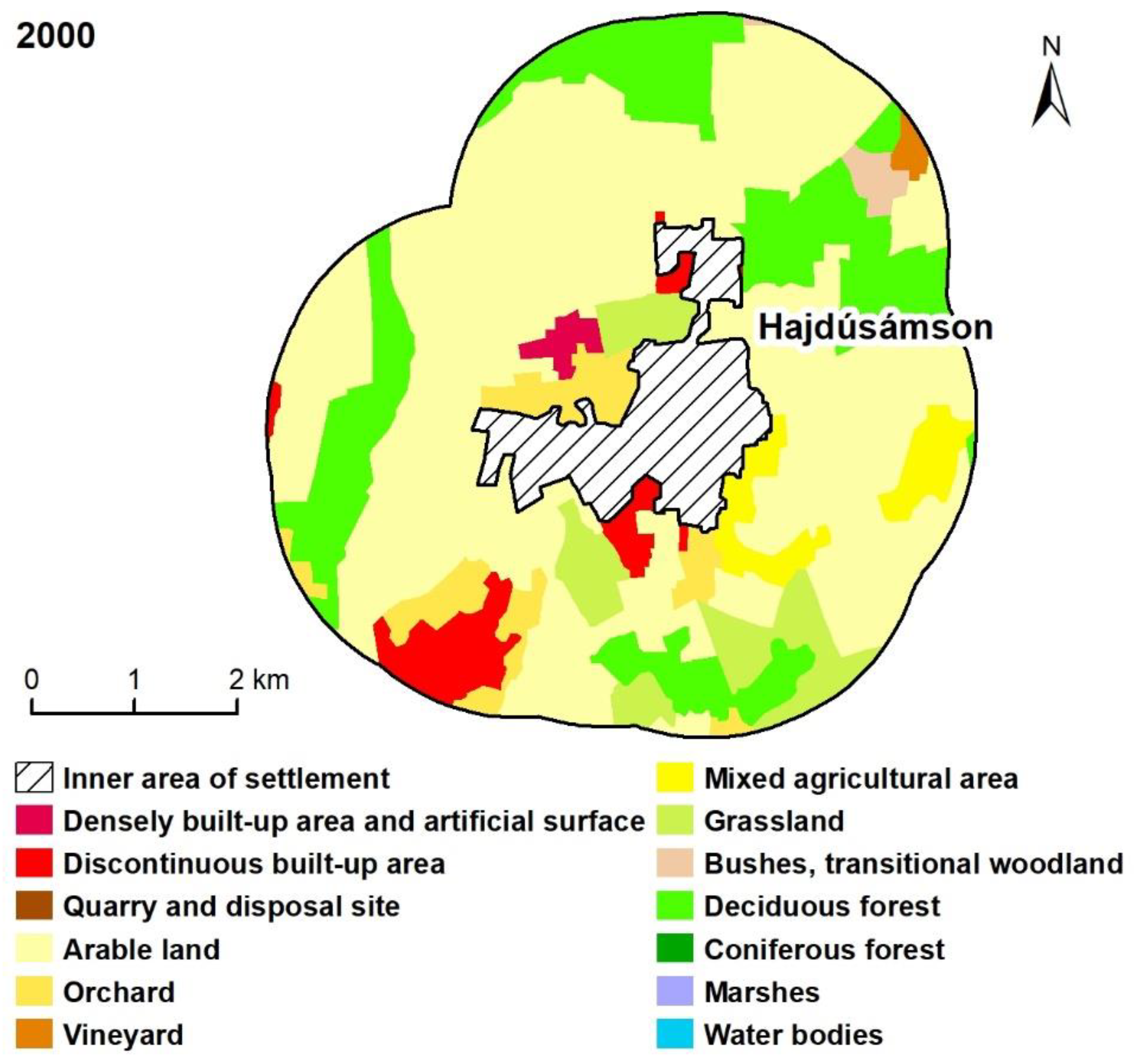
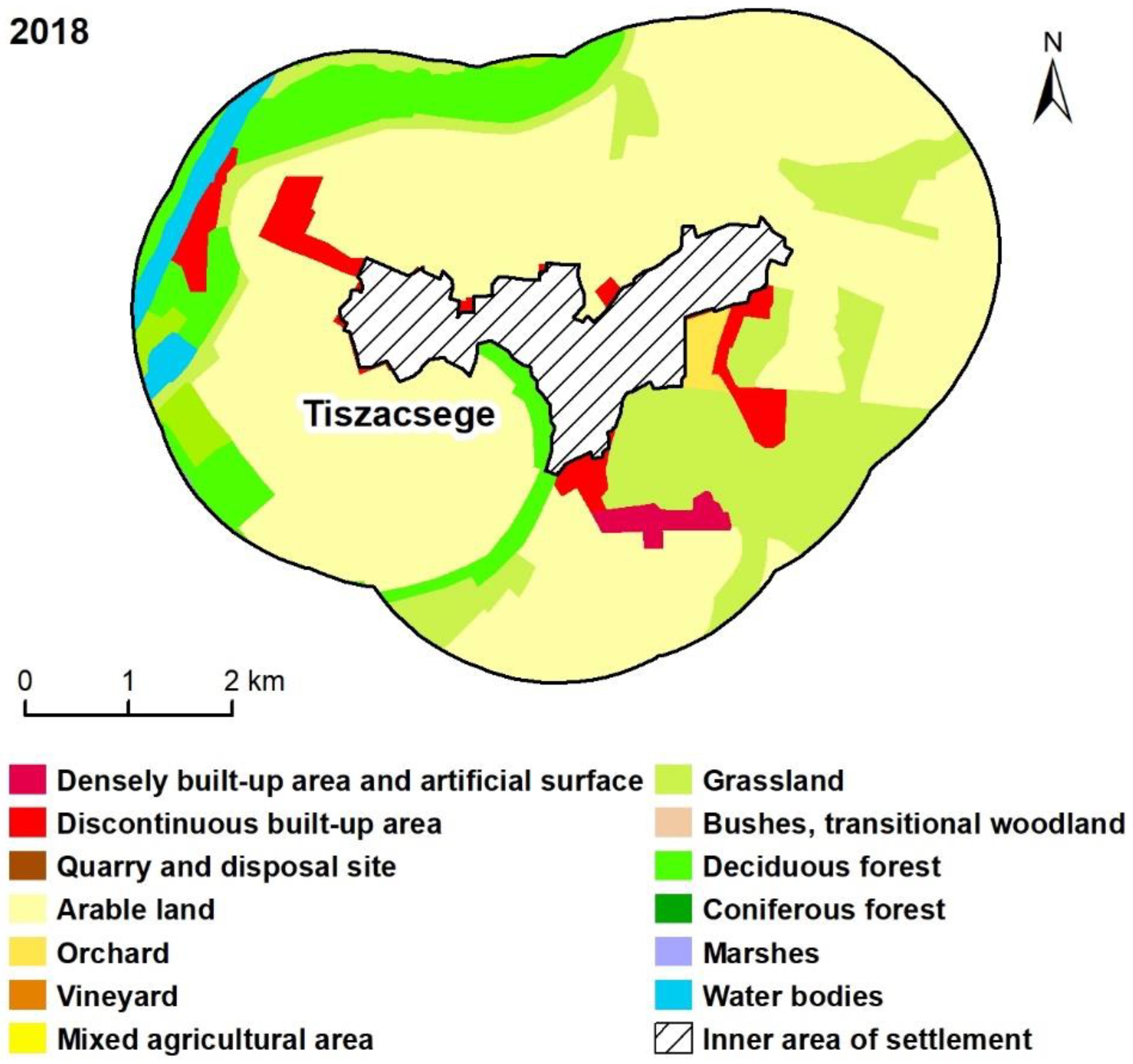
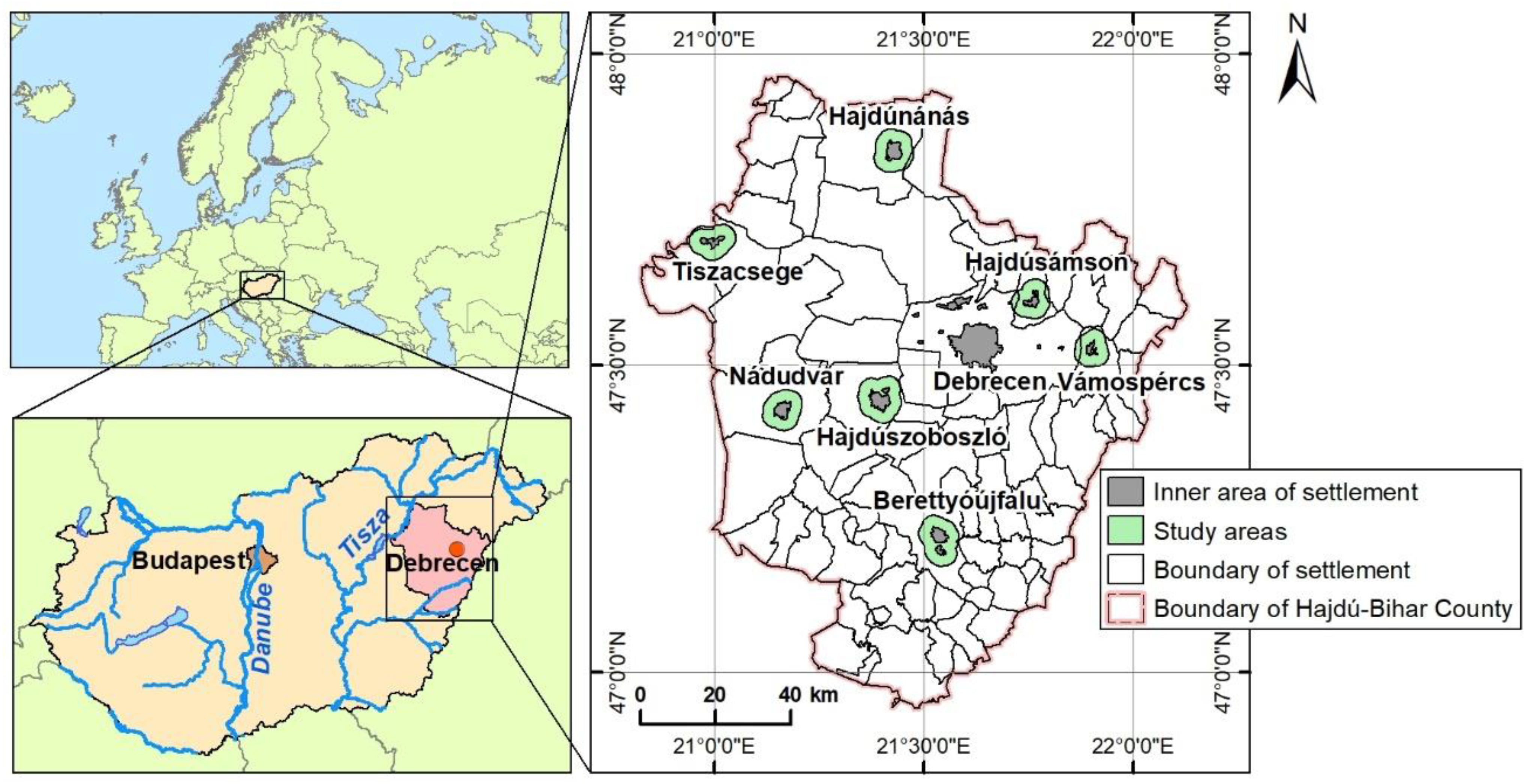
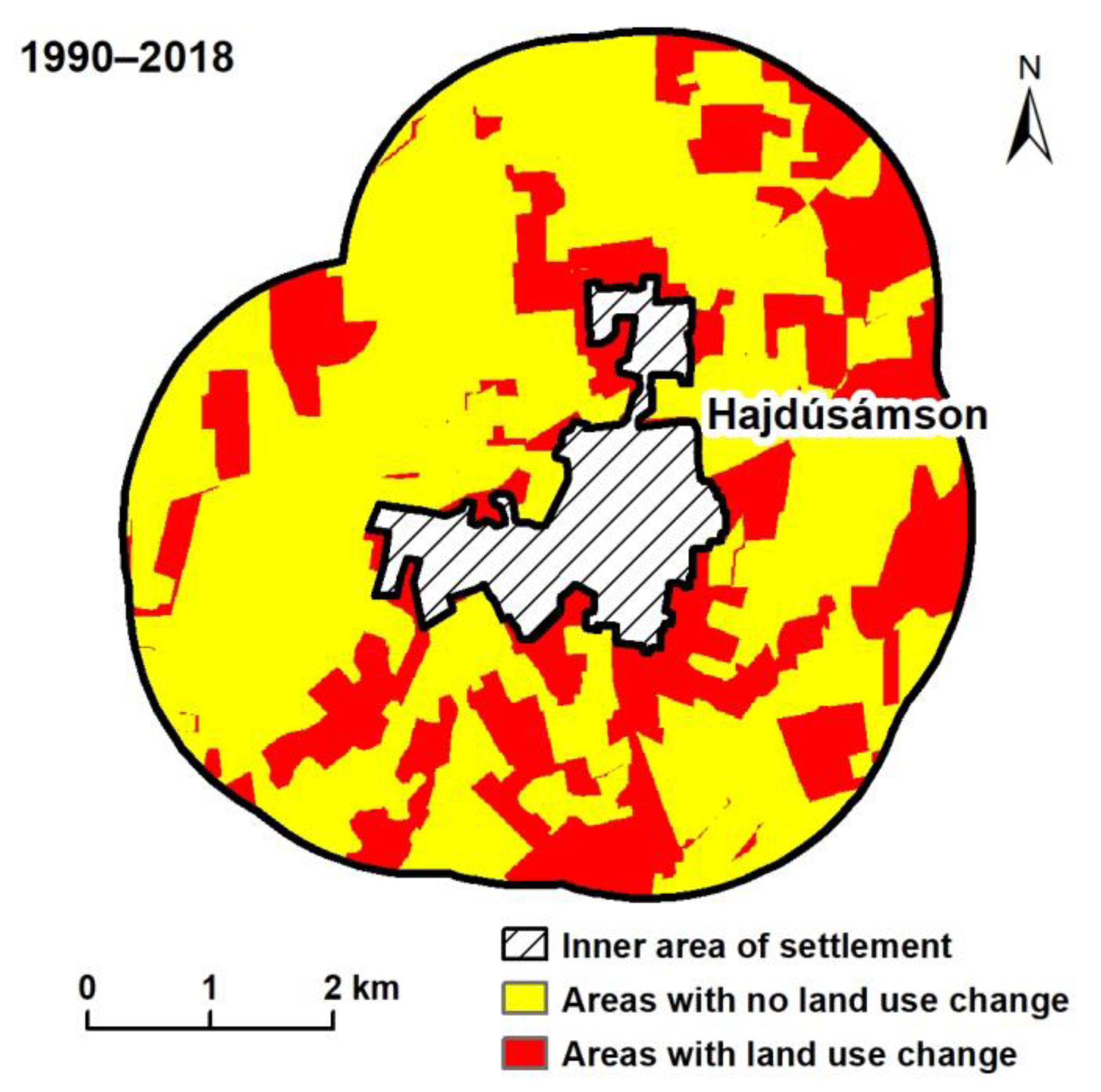
2. Materials and Methods
- Regulation plans, structural plans and so-called image documents of the settlements were analyzed;
- Land use conversions were traced in the Copernicus Corine Land Cover and Land Cover Change database interpretations from 1990 [55], 2000 [56] and 2018 [57]. Changes in the inner parts of the settlements were not dealt with; therefore, the 2 km wide peri-urban open spaces were determined on the basis of the database from 1990. New built-up areas between 1990 and 2018 were not considered this way;
- Land use categories of the Copernicus Corine Land Cover and Land Cover Change databases (in the hierarchical 3-level CLC nomenclature) proved to be too detailed [58,59,60]. Therefore, our own land use categories were created by aggregating the 28 categories that occur in Hungary (Table 1). In the case of vector databases with a scale of 1:100,000, the minimum mapped object size of 25 ha and the minimum width of 100 m for linear elements often provide insufficiently fine spatial resolution [55,56,57,58]. Since no other standardized databases were found in the international literature for the land use analysis of peri-urban open spaces [3,6,16,31], the examinations were carried out taking these technical constraints into account;
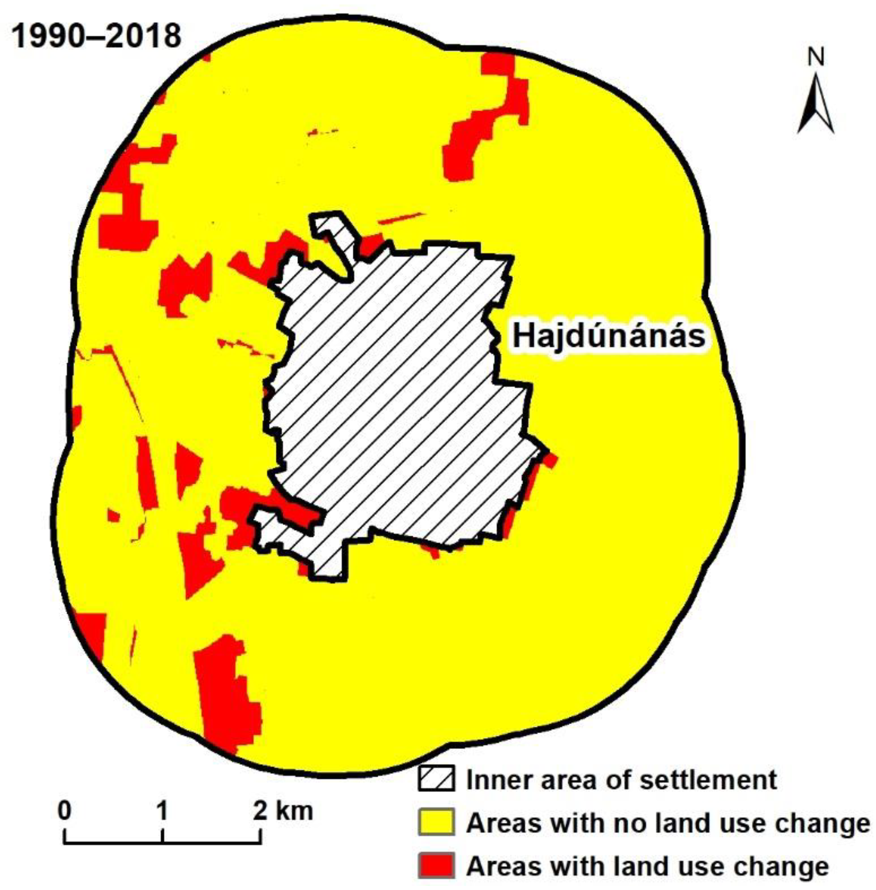
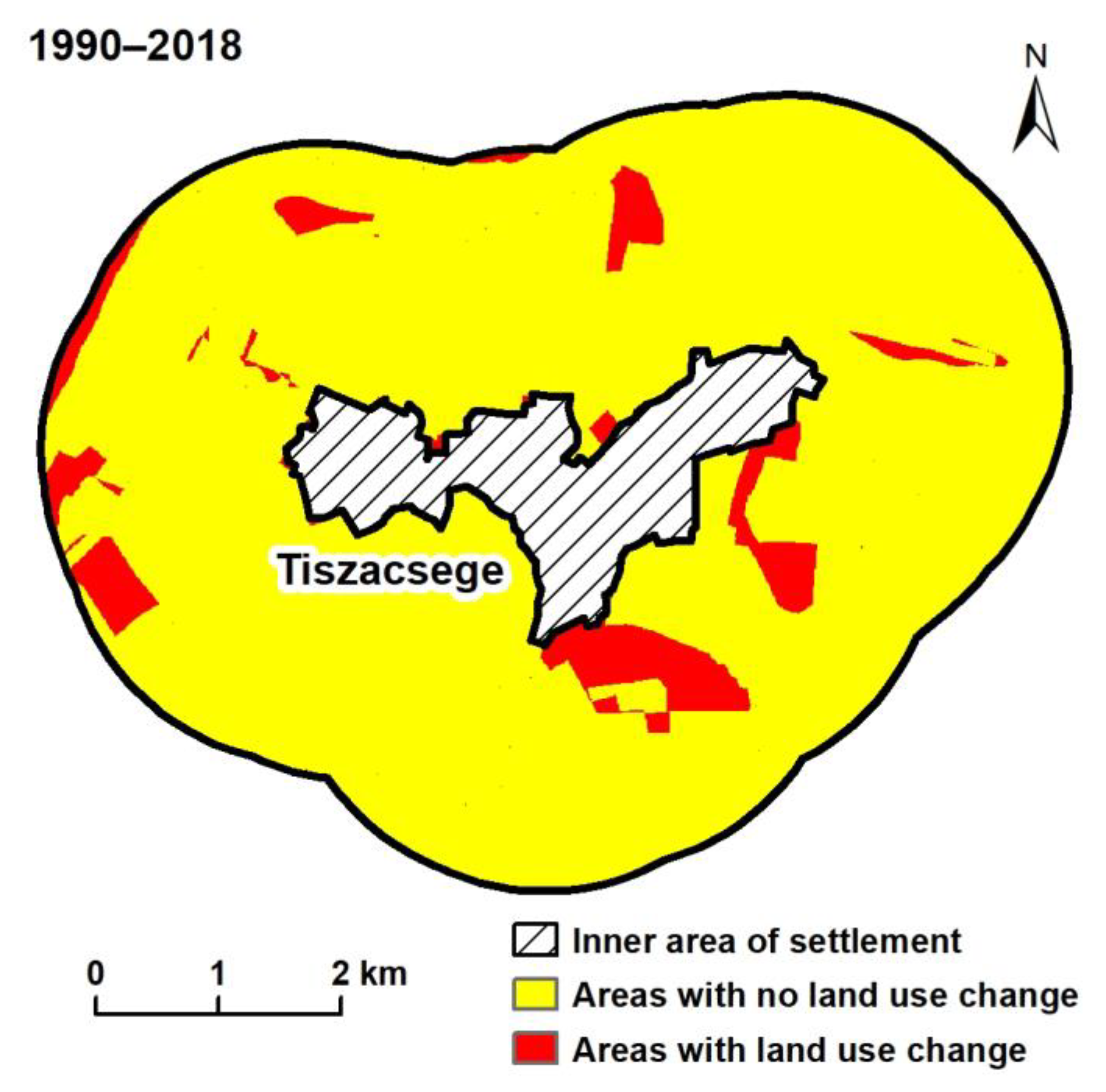
- For analyzing the land use stability of peri-urban open spaces, the vector layers of the Copernicus Corine Land Cover and Land Cover Change databases were rasterized and subtracted from each other in reverse order (1990 was considered the base year). Land use changes in the different study areas and time periods were calculated based on the area size (ha) and the proportion (%). For spatial data analyses and creating the thematic maps, ArcGIS 10.8 software was applied;
- Corine data were checked during the field survey; a landscape character assessment was also made, which was compared to the results of a national-scale landscape character assessment completed in early 2021 [54].
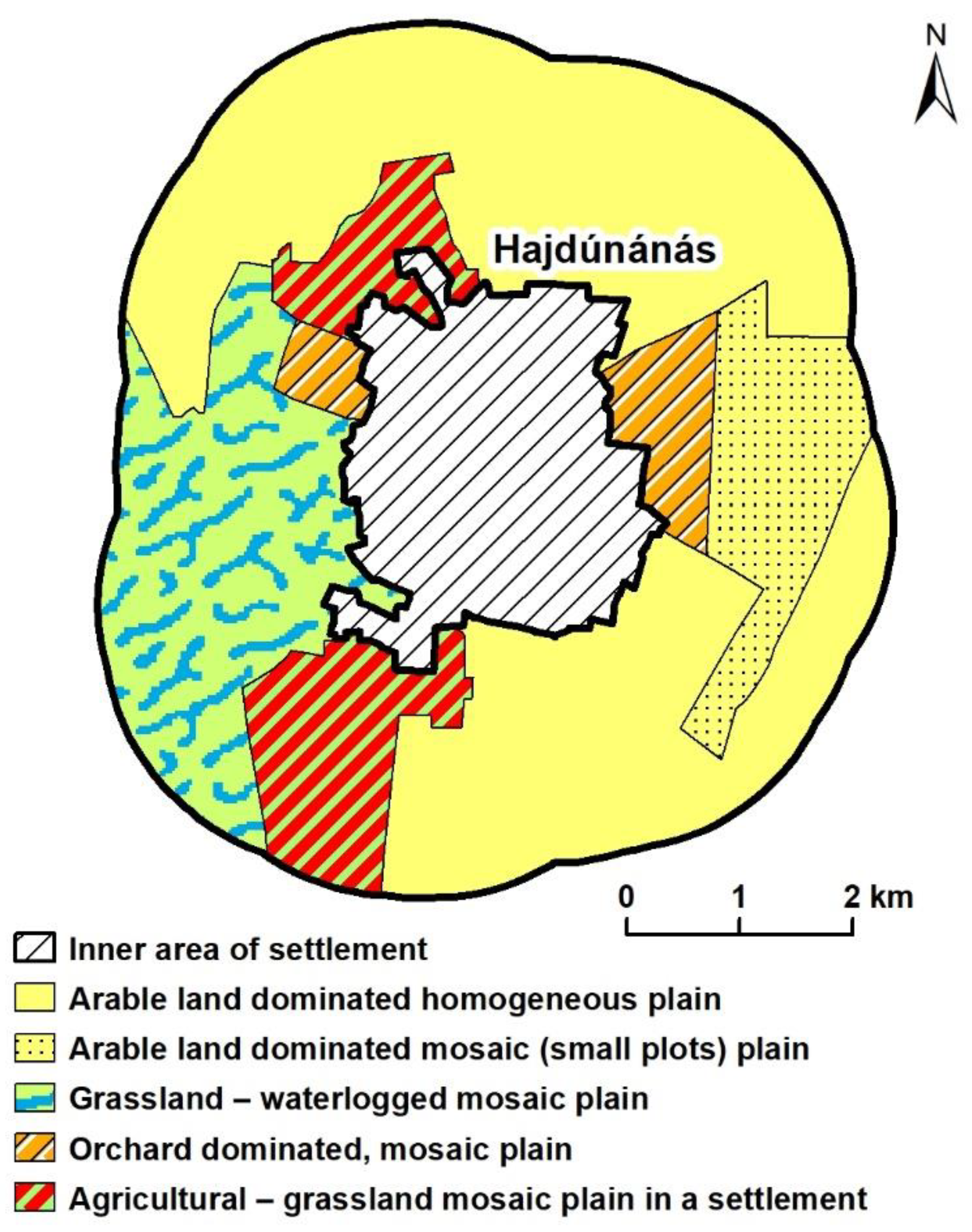
3. Results and Discussion
- Wet meadows and small water flows;
- Close-to-natural (not planted!) forest patches;
- Gardens.
4. Conclusions
Author Contributions
Funding
Institutional Review Board Statement
Informed Consent Statement
Data Availability Statement
Acknowledgments
Conflicts of Interest
References
- Allen, A. Environmental planning and management of the peri-urban interface: Perspectives on an emerging field. Environ. Urban. 2003, 15, 135–148. [Google Scholar] [CrossRef]
- Egedy, T. Strategic and Socio-Economic Implications of Urban Regeneration in Hungary. In Development of the Settlement Network in the Central European Countries: Past, Present, and Future; Csapó, T., Balogh, A., Eds.; Springer: Berlin/Heidelberg, Germany, 2012; pp. 145–160. [Google Scholar] [CrossRef]
- Kovács, Z.; Farkas, Z.J.; Egedy, T.; Kondor, A.C.; Szabó, B.; Lennert, J.; Baka, D.; Kohán, B. Urban sprawl and land conversion in post-socialist cities: The case of metropolitan Budapest. Cities 2019, 92, 71–81. [Google Scholar] [CrossRef]
- Piorr, A.; Ravetz, J.; Tosics, I. Peri-Urbanisation in Europe: Towards European Policy to Sustain Urban-Rural Futures; University of Copenhagen: Copenhagen, Denmark, 2011; p. 144. [Google Scholar]
- Antrop, M. Landscape change and the urbanization process in Europe. Landsc. Urban Plan. 2004, 67, 9–26. [Google Scholar] [CrossRef]
- Barros, J.L.; Tavares, A.O.; Monteiro, M.; Santos, P.P. Peri-Urbanization and Rurbanization in Leiria City: The Importance of a Planning Framework. Sustainability 2018, 10, 2501. [Google Scholar] [CrossRef]
- Kaimaris, D.; Patias, P. Identification and Area Measurement of the Built-up Area with the Built-up Index (BUI). IJARSG 2016, 5, 1844–1858. [Google Scholar] [CrossRef]
- Lichter, D.T.; Ziliak, J.P. The Rural-Urban Interface: New Patterns of Spatial Interdependence and Inequality in America. Ann. Am. Acad. Political Soc. Sci. 2017, 672, 6–25. [Google Scholar] [CrossRef]
- Roose, A.; Kull, A.; Gauk, M.; Tali, T. Land use policy shocks in the post-communist urban fringe: A case study of Estonia. Land Use Policy 2013, 30, 76–83. [Google Scholar] [CrossRef]
- Tacoli, C. The links between urban and rural development. Environ. Urban. 2003, 15, 3–12. [Google Scholar] [CrossRef]
- Balta, S.; Atik, M. Rural planning guidelines for urban-rural transition zones as a tool for the protection of rural landscape characters and retaining urban sprawl: Antalya case from Mediterranean. Land Use Policy 2022, 119, 106144. [Google Scholar] [CrossRef]
- Hersperger, A.M.; Bürgi, M. Going beyond landscape change description: Quantifying the importance of driving forces of landscape change in a Central Europe case study. Land Use Policy 2009, 26, 640–648. [Google Scholar] [CrossRef]
- Sheng, Y.K. Peri-urban transformations in Southeast Asia. In Routledge Handbook of Urbanization in Southeast Asia, 1st ed.; Padawangi, R., Ed.; Routledge: Abingdon, UK; New York, NY, USA, 2019; pp. 31–42. [Google Scholar]
- Simon, D. Urban Environments: Issues on the Peri-Urban Fringe. Annu. Rev. Environ. Resour. 2008, 33, 167–185. [Google Scholar] [CrossRef]
- Csorba, P.; Ádám, S.; Bartos-Elekes, Z.; Bata, T.; Bede-Fazekas, Á.; Czúcz, B.; Csima, P.; Csüllög, G.; Fodor, N.; Frisnyák, S.; et al. Landscapes. In National Atlas of Hungary—Natural Environment, 1st ed.; Kocsis, K., Gercsák, G., Horváth, G., Keresztesi, Z., Nemerkényi, Z., Eds.; MTA CSFK Geographical Institute: Budapest, Hungary, 2018; pp. 112–129. [Google Scholar]
- Bański, J. The consequences of changes of ownership for agricultural land use in Central European countries following the collapse of the Eastern Bloc. Land Use Policy 2017, 66, 120–130. [Google Scholar] [CrossRef]
- Grădinaru, S.R.; Iojă, C.I.; Onose, D.A.; Gavrilidis, A.A.; Pătru-Stupariu, I.; Kienast, F.; Hersperger, A.M. Land abandonment as a precursor of built-up development at the sprawling periphery of former socialist cities. Ecol. Indic. 2015, 57, 305–313. [Google Scholar] [CrossRef]
- Kubeš, J.; Novácek, A. Suburbs around the Czech provincial city of České Budějovice—Territorial arrangement and problems. HunGeoBull 2019, 68, 65–78. [Google Scholar] [CrossRef]
- Lennert, J.; Csatári, B.; Farkas, J.Z.; Mezőszentgyörgyi, D. Locality-Based and Place-Based Development in Theory and Practice—An Example of the Hungarian Countryside. DETUROPE 2015, 7, 14–27. [Google Scholar] [CrossRef]
- Oșlobanu, C.; Alexe, M. Built-up area analysis using Sentinel data in metropolitan areas of Transylvania, Romania. HunGeoBull 2021, 70, 3–18. [Google Scholar] [CrossRef]
- Lennert, J. Felszínborítás-változás a visegrádi országokban a rendszerváltás után. Magy. Tud. 2018, 3, 319–330. [Google Scholar] [CrossRef]
- Doucha, T.; Divila, E. Changes in Czech agriculture in the years 1990–2005. Studia Obsz. Wiej. 2008, 15, 73–95. [Google Scholar]
- Jackson, J.; Garb, Y. Facilitating Brownfield Redevelopment in Central Europe: Overview and Proposals; Institute for Transport and Development Policy: New York, NY, USA, 2002; pp. 1–17. [Google Scholar]
- OECD. Land Cover Change in Countries and Regions: Conversion of Cropland to Artificial Surfaces. Available online: https://stats.oecd.org/ (accessed on 1 March 2022).
- Statistics Flanders. Land Use: Built-Up Area. Available online: https://www.vlaanderen.be/en/statistics-flanders/land-use/built-up-area (accessed on 1 March 2022).
- Geddes, R. Metropolis unbound: The sprawling American city and the search for alternatives. Am. Prospect. 1997, 35, 40–46. [Google Scholar]
- Šveda, M.; Vigašová, D. Land use change in the hinterland of major Slovak cities. Geografie 2010, 115, 413–439. [Google Scholar] [CrossRef]
- Szigeti, C.; Kovács, Z.; Egedy, T.; Szabó, B. Az ingázásból származó ökológiai lábnyom csökkentésének lehetőségei a közösségi gazdaság révén a budapesti városrégióban. Közlekedéstudományi Szle. 2019, 69, 58–74. [Google Scholar] [CrossRef] [Green Version]
- Antrop, M.; Van Eetvelde, V. Landscape Perspectives: The Holistic Nature of Landscape; Springer: Dordrecht, The Netherlands, 2017; Volume 23, p. 436. [Google Scholar] [CrossRef]
- Bryant, C.R.; Charvet, J.P. La zone périurbaine : Structure et dynamiques d’une composante stratégique des régions métropolitaines. Can. J. Reg. Sci. 2003, 26, 241–250. [Google Scholar]
- Izakovičová, Z.; Petrovič, F.; Pauditšová, E. The Impacts of Urbanisation on Landscape and Environment: The Case of Slovakia. Sustainability 2021, 14, 60. [Google Scholar] [CrossRef]
- Kondor, A. Helyi konfliktusok Budapest szuburbán zónájában. Földrajzi Közlemények 2016, 140, 216–228. [Google Scholar]
- Nardino, M.; Laruccia, N. Land Use Changes in a Peri-Urban Area and Consequences on the Urban Heat Island. Climate 2019, 7, 133. [Google Scholar] [CrossRef]
- Adell, G. Theories and models of the peri-urban interface: A changing conceptual landscape. In Development Planning Unit; UCL: London, UK, 1999; p. 46. [Google Scholar]
- Zgliński, W. The essential problems and the structure of Polish agriculture in the period of transformation. Studia Obsz. Wiej. 2008, 15, 45–72. [Google Scholar]
- Pedroli, G.B.M. Landscape—Our Home; Essays on the Culture of the European Landscape as a Task; Indigo: Zeist, The Netherlands, 2000; p. 222. [Google Scholar]
- Pedroli, B.; van Doorn, A.; de Blust, G.; Paracchini, M.L.; Wascher, D.; Bunce, F. (Eds.) Europe’s Living Landscapes: Essays Exploring Our Identity in the Countryside; KNNV Publishing: Zeist, The Netherlands, 2007; p. 432. [Google Scholar]
- Raymond, R.; Luginbühl, Y.; Seguin, J.F.; Cedelle, Q.; Grare, H. Landscape Atlases: Landscape Identification, Characterisation and Assessment Method; Ministère de l’Écologie, du Développement durable et de l’Énergie: Paris, France, 2015; p. 111.
- Csorba, P.; Csatári, B. Tájföldrajz és táji önazonosság. Magy. Tud. 2017, 3, 284–292. [Google Scholar]
- Scott, M.J.; Canter, D.V. Picture or place? A multiple sorting study of landscape. J. Environ. Psychol. 1997, 17, 263–281. [Google Scholar] [CrossRef]
- Simensen, T.; Halvorsen, R.; Erikstad, L. Methods for landscape characterisation and mapping: A systematic review. Land Use Policy 2018, 75, 557–569. [Google Scholar] [CrossRef]
- Devine-Wright, P.; Quinn, T. Dynamics of Place Attachment in a Climate Changed World. In Place Attachment: Advances in Theory, Methods and Applications, 2nd ed.; Manzo, L.C., Devine-Wright, P., Eds.; Routledge: Abingdon, UK; New York, NY, USA, 2020; pp. 226–242. [Google Scholar]
- Kaltenborn, B.P.; Williams, D.R. The meaning of place: Attachments to Femundsmarka National Park, Norway, among tourists and locals. Nor. J. Geogr. 2002, 56, 189–198. [Google Scholar] [CrossRef]
- Kianicka, S.; Buchecker, M.; Hunziker, M.; Müller-Böker, U. Locals’ and tourists’ sense of place: A case study of a Swiss alpine village. Mt. Res. Dev. 2006, 26, 55–63. [Google Scholar] [CrossRef]
- Konkoly-Gyuró, É.; Vaszócsik, V.; Csorba, P.; Schneller, K.; Jombach, S.; Boromissza, Z.; Erdei, T.; Balázs, P.; Kiss, D.; Teleki, M.; et al. Az országos tájkarakter-elemzés kezdetei Magyarországon. Földrajzi Közlemények 2021, 145, 193–208. [Google Scholar] [CrossRef]
- RENATUR Brochure. Available online: https://projects2014-2020.interregeurope.eu/fileadmin/user_upload/tx_tevprojects/library/file_1579699605.pdf (accessed on 20 January 2022).
- Beluszky, P.; Kovács, Z. Settlement system. In National Atlas of Hungary—Society, 1st ed.; Kocsis, K., Klinghammer, I., Nemerkényi, Z., Gercsák, G., Kincses, Á., Kovács, Z., Tóth, G., Zentai, L., Eds.; CSFK Geographical Institute: Budapest, Hungary, 2021; pp. 108–115. [Google Scholar]
- Egedy, T. A kelet-közép-európai városrégiók átalakulása a posztfordi korban—elméleti alapok. Földrajzi Közlemények 2021, 145, 354–368. [Google Scholar] [CrossRef]
- Taubenböck, H.; Gerten, C.; Rusche, K.; Siedentop, S.; Wurm, M. Patterns of Eastern European urbanisation in the mirror of Western trends—Convergent, unique or hybrid? Environ. Plan. B Urban Anal. City Sci. 2019, 46, 1206–1225. [Google Scholar] [CrossRef] [Green Version]
- Faragó, P.; Koncz, G. Felhagyott mezőgazdasági és ipari telephelyek hasznosításának lehetőségei a Gyöngyösi kistérségben. Acta Carolus Robertus 2012, 2, 23–31. [Google Scholar] [CrossRef]
- Kádár, K. Barnamezők Magyarországon. DETUROPE 2011, 3, 122–141. [Google Scholar] [CrossRef]
- Hungarian Standards Institution. Nature Protection. Aesthetec Evaluation of Landscapes MSZ 20372:2004; Hungarian Standards Institution: Budapest, Hungary, 2004; pp. 1–17. [Google Scholar]
- Wallace, K.J. Classification of ecosystem services: Problems and solutions. Biol. Conserv. 2007, 139, 235–246. [Google Scholar] [CrossRef]
- Konkoly-Gyuró, É.; Vaszócsik, V.; Sain, M.; Csorba, P.; Csőszi, M. Landscape Character Research in Hungary; Ministry of Ag-riculture: Budapest, Hungary, 2021; pp. 1–48. [Google Scholar]
- Copernicus Land Monitoring Service. Corine Land Cover 1990. Available online: https://land.copernicus.eu/pan-european/corine-land-cover/clc-1990 (accessed on 10 February 2022).
- Copernicus Land Monitoring Service. Corine Land Cover 2000. Available online: https://land.copernicus.eu/pan-european/corine-land-cover/clc-2000 (accessed on 10 February 2022).
- Copernicus Land Monitoring Service. Corine Land Cover 2018. Available online: https://land.copernicus.eu/pan-european/corine-land-cover/clc2018 (accessed on 10 February 2022).
- Szabó, S. A CLC2000 és CLC50 adatbázisok összehasonlítása tájmetriai módszerekkel. Tájökológiai Lapok 2010, 8, 23–33. [Google Scholar]
- Szilassi, P. Magyarországi kistájak felszínborítás változékonysága és felszínborítás mozaikosságuk változása. Tájökológiai Lapok 2017, 15, 131–138. [Google Scholar]
- Németh, G.; Lóczy, D.; Gyenizse, P. Long-Term Land Use and Landscape Pattern Changes in a Marshland of Hungary. Sustainability 2021, 13, 12664. [Google Scholar] [CrossRef]
- Council of Europe. European Landscape Convention and Reference Documents; Council of Europe Publishing Division: Strasbourg, France, 2000; p. 94. Available online: https://www.iflaeurope.eu/assets/docs/European_Landscape_Convention-Txt-Ref_en.pdf_.pdf (accessed on 27 January 2022).
- Ministry of Agriculture. Hungarian National Landscape Strategy 2017-2026; Department of National Parks and Landscape Protection, Ministry of Agriculture: Budapest, Hungary, 2017; p. 75. Available online: https://2015-2019.kormany.hu/download/f/8f/11000/Hungarian%20National%20Landscape%20Strategy_2017-2026_webre.pdf (accessed on 3 February 2022).
- Fairclough, G.; Herlin, I.S.; Swanwick, C. (Eds.) Routledge Handbook of Landscape Character Assessment: Current Approaches to Characterisation and Assessment, 1st ed.; Routledge: Abingdon, UK; New York, NY, USA, 2018; p. 294. [Google Scholar]
- Swanwick, C. Landscape Character Assessment. Guidance for England and Scotland; The Countryside Agency: Gloucestershire, UK; Scottish Natural Heritage: Edinburgh, UK, 2002; p. 104. [Google Scholar]
- Wascher, D.M. (Ed.) European Landscape Character Areas—Typologies, Cartography and Indicators for the Assessment of Sustainable Landscapes; No. 1254; Landscape Europe: Wageningen, The Netherlands, 2005; p. 148. [Google Scholar]
- Koç, A.; Yılmaz, S. Landscape character analysis and assessment at the lower basin-scale. Appl. Geogr. 2020, 125, 102359. [Google Scholar] [CrossRef]
- Belén, M.; Ortega, E.; Martino, P.; Otero, I. Inferring landscape change from differences in landscape character between the current and a reference situation. Ecol. Indic. 2018, 90, 584–593. [Google Scholar] [CrossRef]
- Csorba, P. A földrajzi tájakhoz fűződő identitástudat rétegei. Tájökológiai Lapok 2010, 8, 3–21. [Google Scholar]
- Egedy, T.; Kovács, Z.; Kondor, A.C. Metropolitan region building and territorial development in Budapest: The role of national policies. Int. Plan. Stud. 2017, 22, 14–29. [Google Scholar] [CrossRef]
- Kovács, Z.; Hegedűs, G. Gated communities as new forms of segregation in post-socialist Budapest. Cities 2014, 36, 200–209. [Google Scholar] [CrossRef]
- Vasárus, G.; Bajmócy, P.; Lennert, J. In the shadow of the city: Demographic processes and emerging conflicts in the rural-urban fringe of the Hungarian agglomerations. Geogr. Pannonica 2018, 22, 14–29. [Google Scholar] [CrossRef]
- Ianos, I.; Sirodoev, I.; Pascariu, G. Land-use conflicts and environmental policies in two post-socialist urban agglomerations: Bucharest and Chișinău. Carpathian J. Earth Environ. Sci. 2012, 7, 125–136. [Google Scholar]
- Miljković, J.Ž.; Crnčević, T.; Marić, I. Land use planning for sustainable development of peri-urban zones. Spatium 2012, 28, 15–22. [Google Scholar] [CrossRef]
- Žoncová, M. Evaluation of the diversification of rural landscape in Slovakia after 1989 with a focus on the built-up area of municipalities: A case study of Podhájska municipality. HunGeoBull 2018, 67, 143–158. [Google Scholar] [CrossRef]
- Cséfalvay, Z. Searching for Economic Rationale behind Gated Communities: A Public Choice Approach. Urban Stud. 2011, 48, 749–764. [Google Scholar] [CrossRef]
- évi LXXIV. törvény a településkép védelméről. Available online: https://net.jogtar.hu/jogszabaly?docid=a1600074.tv (accessed on 7 February 2022).
- Lechner Knowledge Center Non-Profit Limited Company. Colour Ortophotos (ID: 68-423, 79-112, 79-114, 79-121, 79-123) 2011. Available online: https://geoshop.hu/car (accessed on 19 February 2022).
- Jiménez-Olivencia, Y.; Ibáñez-Jiménez, Á.; Porcel-Rodríguez, L.; Zimmerer, K. Land use change dynamics in Euro-mediterranean mountain regions: Driving forces and consequences for the landscape. Land Use Policy 2021, 109, 105721. [Google Scholar] [CrossRef]


| Corine Nomenclature | Our Aggregated Land Use Types |
|---|---|
| 1.1.1. Continuous urban fabric | 1. Densely built-up area and artificial surface |
| 1.2.1. Industrial or commercial units 1.2.2. Road and rail networks and associated land 1.2.3. Port areas 1.2.4. Airports | |
| 1.1.2. Discontinuous urban fabric 1.4.1. Green urban areas 1.4.2. Sport and leisure facilities | 2. Discontinuous built-up area |
| 1.3.1. Mineral extraction sites 1.3.2. Dump sites 1.3.3. Construction sites | 3. Quarry and disposal site |
| 2.1.1. Non-irrigated arable land 2.1.3. Rice fields | 4. Arable land |
| 2.2.2. Fruit trees and berry plantations 2.4.2. Complex cultivation patterns | 5. Orchard |
| 2.2.1. Vineyards | 6. Vineyard |
| 2.4.3. Land principally occupied by agriculture, with significant areas of natural vegetation | 7. Mixed agricultural area |
| 2.3.1. Pastures 3.2.1. Natural grasslands 3.3.3. Sparsely vegetated areas | 8. Grassland |
| 3.2.4. Transitional woodland-shrub | 9. Bushes, transitional woodland |
| 3.1.1. Broad-leaved forest 3.1.3. Mixed forest | 10. Deciduous forest |
| 3.1.2. Coniferous forest | 11. Coniferous forest |
| 4.1.1. Inland marshes 4.1.2. Peat bogs | 12. Marshes |
| 5.1.1. Water courses 5.1.2. Water bodies | 13. Water bodies |
| Peri-Urban Zones | Land Use Types | Area (ha) | Proportion (%) | ||||
|---|---|---|---|---|---|---|---|
| Year | Year | ||||||
| 1990 | 2000 | 2018 | 1990 | 2000 | 2018 | ||
| Hajdúnánás | Densely built-up area and artificial surface | 28.13 | 28.13 | 47.88 | 0.77 | 0.77 | 1.31 |
| Discontinuous built-up area | 0.00 | 14.24 | 39.84 | 0.00 | 0.39 | 1.09 | |
| Quarry and disposal site | 0.00 | 0.00 | 0.00 | 0.00 | 0.00 | 0.00 | |
| Arable land | 2369.93 | 2432.75 | 2438.26 | 64.78 | 66.49 | 66.64 | |
| Orchard | 287.09 | 237.38 | 235.46 | 7.85 | 6.49 | 6.44 | |
| Vineyard | 0.00 | 0.00 | 0.00 | 0.00 | 0.00 | 0.00 | |
| Mixed agricultural area | 84.89 | 0.00 | 0.00 | 2.32 | 0.00 | 0.00 | |
| Grassland | 761.01 | 809.39 | 749.16 | 20.80 | 22.12 | 20.48 | |
| Bushes, transitional woodland | 0.00 | 0.00 | 0.00 | 0.00 | 0.00 | 0.00 | |
| Deciduous forest | 0.00 | 0.00 | 0.00 | 0.00 | 0.00 | 0.00 | |
| Coniferous forest | 0.00 | 0.00 | 0.00 | 0.00 | 0.00 | 0.00 | |
| Marshes | 32.14 | 44.75 | 44.63 | 0.88 | 1.22 | 1.22 | |
| Water bodies | 95.45 | 92.01 | 103.43 | 2.61 | 2.51 | 2.83 | |
| Total | 3658.65 | 3658.65 | 3658.65 | 100.00 | 100.00 | 100.00 | |
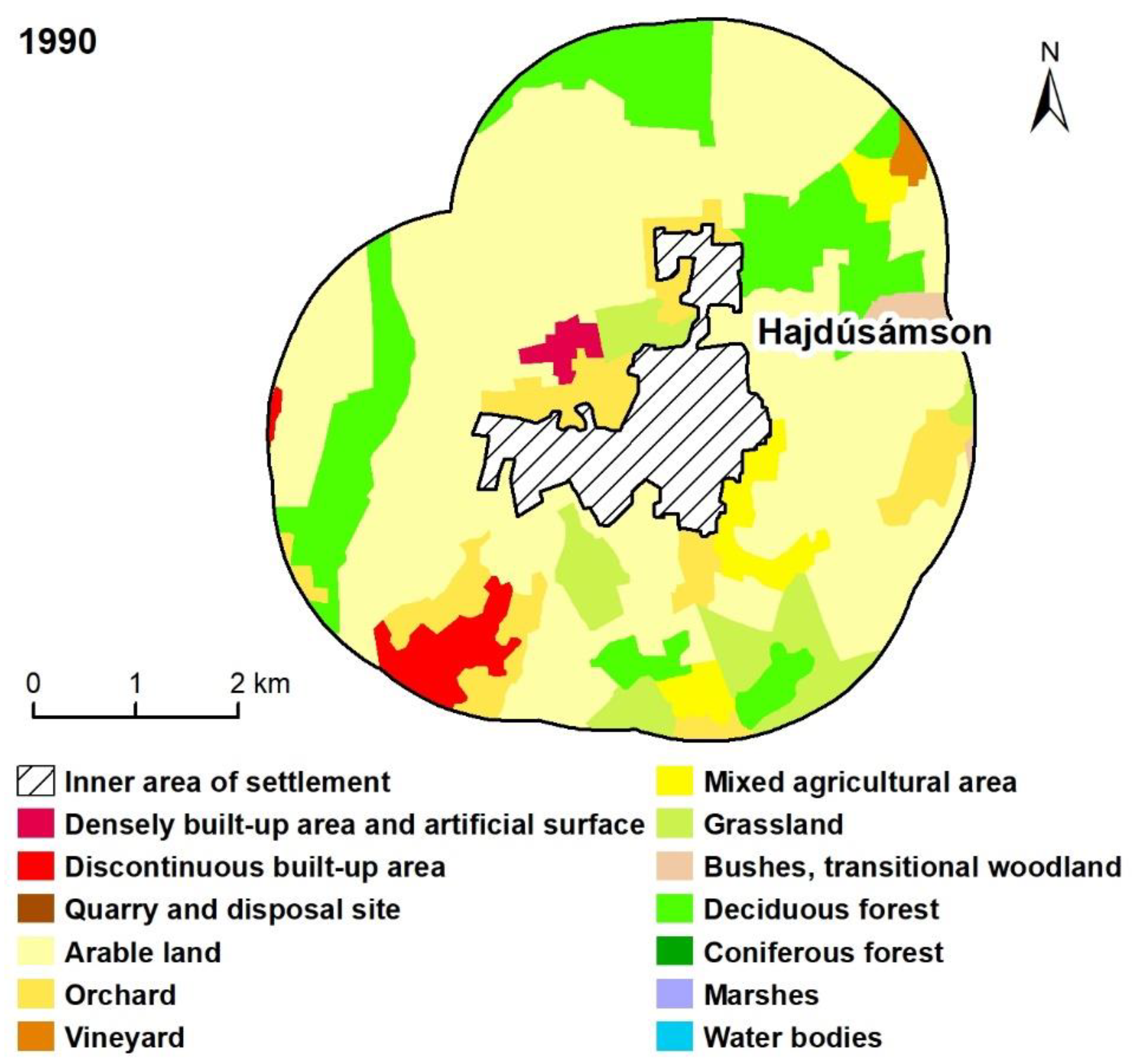
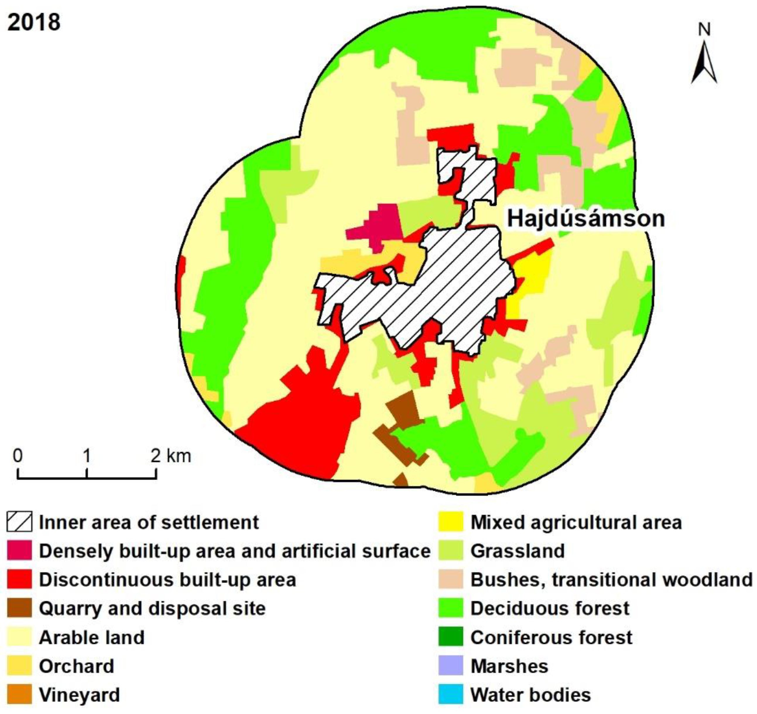
| Hajdúsámson | Densely built-up area and artificial surface | 26.37 | 26.37 | 32.29 | 0.78 | 0.78 | 0.95 |
| Discontinuous built-up area | 86.48 | 136.65 | 348.00 | 2.55 | 4.03 | 10.27 | |
| Quarry and disposal site | 0.00 | 0.00 | 38.44 | 0.00 | 0.00 | 1.13 | |
| Arable land | 2038.14 | 2038.24 | 1584.76 | 60.15 | 60.16 | 46.77 | |
| Orchard | 298.18 | 185.06 | 102.79 | 8.80 | 5.46 | 3.03 | |
| Vineyard | 15.00 | 15.01 | 0.00 | 0.44 | 0.44 | 0.00 | |
| Mixed agricultural area | 122.00 | 116.33 | 32.54 | 3.60 | 3.43 | 0.96 | |
| Grassland | 226.79 | 218.70 | 331.70 | 6.69 | 6.45 | 9.79 | |
| Bushes, transitional woodland | 40.95 | 29.15 | 226.27 | 1.21 | 0.86 | 6.68 | |
| Deciduous forest | 534.36 | 622.77 | 691.48 | 15.77 | 18.38 | 20.41 | |
| Coniferous forest | 0.00 | 0.00 | 0.00 | 0.00 | 0.00 | 0.00 | |
| Marshes | 0.00 | 0.00 | 0.00 | 0.00 | 0.00 | 0.00 | |
| Water bodies | 0.00 | 0.00 | 0.00 | 0.00 | 0.00 | 0.00 | |
| Total | 3388.28 | 3388.28 | 3388.28 | 100.00 | 100.00 | 100.00 | |
| Tiszacsege | Densely built-up area and artificial surface | 35.70 | 35.70 | 35.04 | 0.99 | 0.99 | 0.97 |
| Discontinuous built-up area | 65.01 | 73.89 | 140.41 | 1.80 | 2.04 | 3.88 | |
| Quarry and disposal site | 0.00 | 0.00 | 0.00 | 0.00 | 0.00 | 0.00 | |
| Arable land | 2325.34 | 2364.85 | 2274.29 | 64.32 | 65.41 | 62.91 | |
| Orchard | 33.97 | 0.00 | 25.29 | 0.94 | 0.00 | 0.70 | |
| Vineyard | 30.34 | 30.34 | 0.00 | 0.84 | 0.84 | 0.00 | |
| Mixed agricultural area | 0.00 | 0.00 | 0.00 | 0.00 | 0.00 | 0.00 | |
| Grassland | 660.54 | 628.04 | 657.15 | 18.27 | 17.37 | 18.18 | |
| Bushes, transitional woodland | 21.05 | 54.65 | 48.31 | 0.58 | 1.51 | 1.34 | |
| Deciduous forest | 371.48 | 355.96 | 363.10 | 10.28 | 9.85 | 10.04 | |
| Coniferous forest | 0.00 | 0.00 | 0.00 | 0.00 | 0.00 | 0.00 | |
| Marshes | 0.93 | 0.93 | 0.93 | 0.03 | 0.03 | 0.03 | |
| Water bodies | 70.90 | 70.90 | 70.72 | 1.96 | 1.96 | 1.96 | |
| Total | 3615.26 | 3615.26 | 3615.26 | 100.00 | 100.00 | 100.00 | |
Publisher’s Note: MDPI stays neutral with regard to jurisdictional claims in published maps and institutional affiliations. |
© 2022 by the authors. Licensee MDPI, Basel, Switzerland. This article is an open access article distributed under the terms and conditions of the Creative Commons Attribution (CC BY) license (https://creativecommons.org/licenses/by/4.0/).
Share and Cite
Csorba, P.; Bánóczki, K.; Túri, Z. Land Use Changes in Peri-Urban Open Spaces of Small Towns in Eastern Hungary. Sustainability 2022, 14, 10680. https://doi.org/10.3390/su141710680
Csorba P, Bánóczki K, Túri Z. Land Use Changes in Peri-Urban Open Spaces of Small Towns in Eastern Hungary. Sustainability. 2022; 14(17):10680. https://doi.org/10.3390/su141710680
Chicago/Turabian StyleCsorba, Péter, Krisztina Bánóczki, and Zoltán Túri. 2022. "Land Use Changes in Peri-Urban Open Spaces of Small Towns in Eastern Hungary" Sustainability 14, no. 17: 10680. https://doi.org/10.3390/su141710680
APA StyleCsorba, P., Bánóczki, K., & Túri, Z. (2022). Land Use Changes in Peri-Urban Open Spaces of Small Towns in Eastern Hungary. Sustainability, 14(17), 10680. https://doi.org/10.3390/su141710680