Article

Territorial Mining Scenarios for Sustainable Land-Planning: A Risk-Based Comparison on the Example of Gold Mining in French Guiana

by
Ottone Scammacca
1,2,*,
Rasool Mehdizadeh
2 and
Yann Gunzburger
2
1
UMR ECOSYS, Université Paris-Saclay, INRAE, AgroParisTech, 91120 Palaiseau, France
2
GeoRessources, Université de Lorraine—CNRS, Mines Nancy, Campus Artem, BP 14234, 54042 Nancy, France
*
Author to whom correspondence should be addressed.
Sustainability 2022, 14(17), 10476; https://doi.org/10.3390/su141710476
Submission received: 11 July 2022 / Revised: 12 August 2022 / Accepted: 22 August 2022 / Published: 23 August 2022
(This article belongs to the Special Issue Sustainability in Mining)

Abstract

:
Mining can be the source and target of opportunities and threats of different natures exceeding the mine site perimeter, affecting the socio-ecological system and leading to social conflicts and entrepreneurial risks for mining companies. Hence, a mining project is a matter of land planning rather than a simple industrial object. Nevertheless, current mandatory risk and impact assessment methods are often performed on one project at a time, neglecting the coexistence of different mining activities and the socio-ecological vulnerability of the territory where mining takes place. This paper proposes an original risk-based approach to develop and compare different territorial mining scenarios (TMSs) to support land-planning strategies in mining territories, tested on the French Guiana gold mining sector. Five TMSs combining different mine types (e.g., legal artisanal, medium, large-scale mining, illegal mining) were developed for the same total amount of gold production at the watershed level. For each TMS, both accidental and ordinary risk scenarios were assessed through a GIS-based approach considering watershed socio-ecological vulnerability. Risks were finally weighted according to different stakeholders’ perception, and the TMSs were compared based on their global risk scores. Despite the multiple challenges highlighted, this paper highlights the feasibility of a methodological framework to support mining planning at the territory level.

1. Introduction

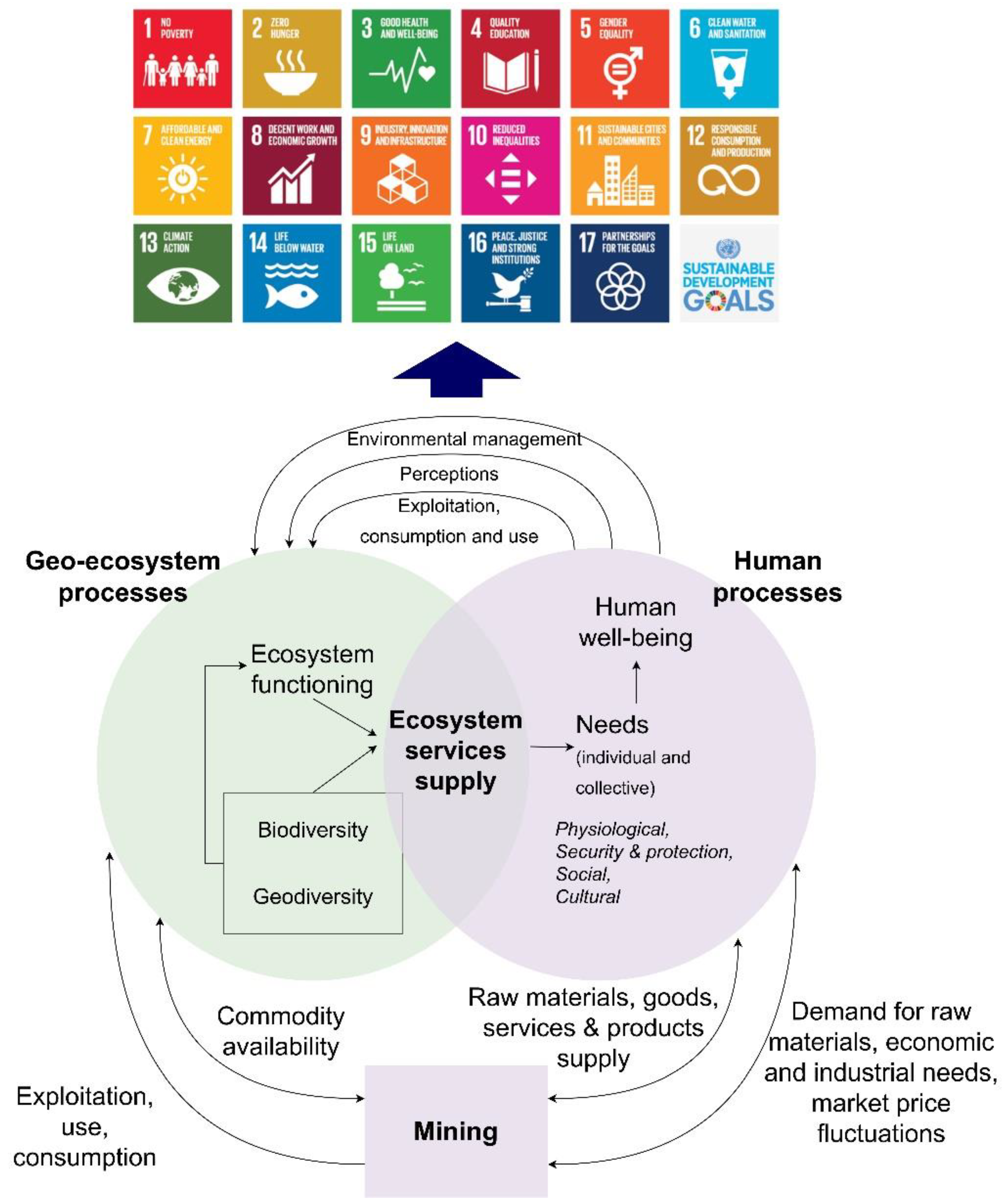
1.1. Mining, Territories and Risks

In the current context of global changes, mining industries must respond to a growing demand for minerals and metals while facing critical socio-environmental challenges [1,2,3,4]. On the one hand, as with other human activities, mining is a potential driver for socio-economic development in terms, for instance, of raw materials supply, the creation of wealth and jobs, technological development, local business development and infrastructures expansion [5], which can be seen as positive risks. On the other hand, mining is also the potential source of threats (i.e., negative risks) affecting ecosystem services supply over time and space (e.g., soil, water and air degradation, fragmentation of natural habitats) [6,7,8] and human well-being (e.g., poor health condition, social conflicts, insecurity) [9,10,11]. Such positive and negative risks often exceed the perimeter of the mine site and may affect the whole territory where a mine is located. Furthermore, when opportunities are outweighed, negative outcomes of mining rebound on mining operators through social conflicts [12,13,14], sanctions and delays, leading to entrepreneurial risks and financial losses [15,16].
Since socio-economic development should not compromise socio-environmental integrity, the concept of sustainability was introduced in the mining sector through the adoption of practices “that result in environmental and social improvements over traditional resource development methods” [3,17] (p. 284.). Today, traditional mining performances related to the internal operational sphere of the mine (e.g., financial viability, workforce requirements, extraction efficiency, resource supply) are completed with socio-ecological standards largely discussed by the scientific community [18,19,20,21,22,23]. Such standards are promoted by international initiatives, such as the Global Report Initiative [24], and recognized by international and national policies [25] to meet Sustainable Development Goals (SDGs) [26] and environmental, social and governance (ESG) performances [27,28] (Figure 1).
Therefore, mining projects are a matter of land-planning rather than simple standalone industrial objects. The role of mining within land management relies on multiple factors, such as land-use, which means questioning which purposes and needs a territory is intended to be managed for and what potential threats and opportunities are associated with such uses. Figure 1 conceptualizes the mutual links between a mine and the territory where it is located. In socio-geo-ecological systems, the functioning of the geo-ecological sphere might satisfy the needs of human societies (e.g., drinking water, recreational activities, air quality regulation), which are translated into different strategies of resource management and land-planning. Depending on how these strategies adhere to recognized international (e.g., SDGs) or local standards, they might positively and/or negatively affect geo-ecological functioning and, hence, the corresponding human needs through feedback loops. As type of land use, mining uses natural and geo-resources to provide services to the anthroposphere. At the same time., mining affects the supply of ecosystem services—defined as the benefits that people obtain from ecosystems [29]—and the satisfaction of the corresponding human needs [7,30]. As a matter of land-planning, mining is also a (geo)political issue, tied to governance factors and global market trends. This implies the questioning of which development models and future scenarios decision makers and stakeholders choose for a given territory.
Such considerations are particularly true for sparsely populated regions [31] such as French Guiana (FG), an overseas European and French territory located in South America between northern Brazil and Suriname (Figure 2). FG faces increasing pressures from anthropic activities due to global changes (e.g., demographic growth, land-use changes) [32] and to its high socio-ecological vulnerability. FG is considered as an important biodiversity wilderness area [33] and a global challenge to conservation and territory management [34,35]. Human settlement is particularly clustered along coastal lowlands and along the Oyapock and Maroni rivers (Figure 2), while more than 96% of the region is covered by tropical rainforest [36]. Future development strategies of FG may imply the conversion of forestlands into urban, agricultural, industrial and mining areas, encouraging decision makers to combine territorial development with the preservation of ecosystem services supply [37]. For such purposes, scenarios have been proposed by researchers, for instance, through the GIS-based software GuyaSim, to analyze the impacts of potential anthropogenic drivers (e.g., urban, agricultural, industrial) on forest-related ecosystem services through climate change and socio-economic scenarios [38]. However, mining activities in FG are often not considered by such approaches or, in other cases, are analyzed through secondary or coarse data not fully accounting for the variability of such activities [32]. Indeed, gold is the main mineral commodity exploited in FG, and its extraction plays a key role in the historical and current socio-environmental and governance dynamics of the territory [39]. In addition, due to the heterogeneity of gold deposits, a wide variety of coexisting gold mines of different sizes and techniques (e.g., legal, illegal, artisanal, medium, large-scale) is distributed at the territory level, particularly over the two greenstone belts where gold mineralization mainly occurs [35,40] (Figure 2). By the end of 2021, approximatively 89 mining permits, including exploration and exploitation, targeted FG gold commodities [41]. French local authorities declared that gold mining can be a major driver for the development of FG and that mining planning is a key issue for FG management [42]. Major concerns and debates focus on potential large-scale mines, such as the Camp Caiman and the Montagne d’Or projects—suspended by the French government, respectively, in 2008 and 2018—and on two newly proposed large-scale gold mines [43], currently under the monitoring of authorities and civil society. Scenario-based approaches to support territorial management of FG were developed by European programs, researchers and local authorities, for instance, through the GIS-based software GuyaSim [38] or the ECOSEO and MOVE projects [32]. However, gold mining impacts on territorial dynamics are often underrepresented in such approaches, and no distinctions are made between legal and illegal, or artisanal and medium and large-scale gold mines.

1.2. A Brief State of the Art of Risk and Impact Assessment Methods in the Mining Sector

A wide range of tools and methods designed for general industrial risk assessment [44] are currently applied to the mining sector [1,45,46,47,48,49]. Nevertheless, such tools are designed to use at the mine-scale, often on one project at the time, and disregard some specificities of mining. Indeed, current mandatory risk and impact assessment methods are often project-centered [50]. They focus only on the objectives at the project level, neglecting the occurrence of multiple coexisting mining projects of different types in a given area and the cumulative risks generated [50,51]. Such methods are not resistant to data availability [47]. These methods are often performed on large capital stock investment projects and sometimes do not account for the transversal nature of risks (e.g., social, environmental, geotechnical). Part of the scientific community has highlighted the limits and poor implementation of widely recognized tools, such as the Environmental Impact Assessment [52,53], which seems to lack homogeneous methodologies of application and has not been “fully integrated into determinative institutional patterns of decision-making” [54]. However, the introduction of sustainable development into mining has encouraged existing studies to focus on the integration of climate change and sustainability challenges within risk assessment methods in the mining sector. Some authors have proposed fuzzy logic to assess mining risks and performances to meet sustainable goals [55,56]. In other cases, fuzzy logic was used to assess mining risks of different natures (e.g., financial, social, health and safety, environmental) throughout the whole mineral supply chain [57]. Indeed, other authors have suggested the improvement of life-cycle assessment (LCA) thinking among mining professionals [58]. Few studies have also focused on the development of LCA at the territory level [59]. Nevertheless, despite their advantages, LCA studies may have neglected the technical variability and the specific features of mining, relying on inadequate datasets [60,61]. Since information related to mining is often limited to corporate reports, the mining system is often considered a “black box” not fully integrated in the assessment [58]. Some specific methods assess risks of multiple projects at the same time [62] for project portfolio risk management [63,64]. However, such methods focus on the industrial dimension of the project. Risks are identified and assessed based on the internal objectives of the project, focusing on project customers [62] rather than territory stakeholders (e.g., local communities, public administration). To the best of our knowledge, the application of such methods to the mining sector has not been described in the scientific literature.
Finally, SWOT analysis (i.e., Strengths, Weaknesses, Opportunities and Threats) has been widely applied to the mining sector [65,66], allowing project managers to develop business goals while understanding the viability of a project. Although SWOT analyses are an effective preliminary tool to summarize information, they do not prioritize issues or provide solutions or alternative decisions and cannot fully assess the strategic decision-making process [67]. For such reasons, SWOT analyses are often combined with other tools to support decision-making, such as the Analytical Network Process (ANP) or TOPSIS [68,69], Analytical Hierarchical Process (AHP) or MARCOS (Measurement of Alternatives and Ranking According to Compromise) [67,69]. As shown by the authors of [69], the combination of SWOT with such tools allows more quantitative and prospecting studies, enabling the comparison of sustainable planning strategies in the mining sector.

1.3. Objectives of the Study

Whether one or more mines should be developed on a territory is a political matter. Through the case study of gold mining in FG, we suggest a new way to look at this question through the development of a risk-based approach to compare multiple potential territorial mining scenarios to support decision-making for sustainable land-planning. A methodological framework (Figure 3) was developed, and its feasibility was tested the first time on the case of gold mining in French Guiana to: (i) provide a terminological structure based on international guidelines [70] at wider spatial extents, (ii) operationalize and test within a scenario-based approach the typology developed by the authors of [40] to consider the potential coexistence of various types of gold mines in the same territory, (iii) integrate the socio-ecological vulnerability of the territory where mining is performed, (iv) consider both positive and negative risks (e.g., technical, environmental, financial, social), (v) adapt to available data and (vi) involve stakeholders’ participation and risk perception.

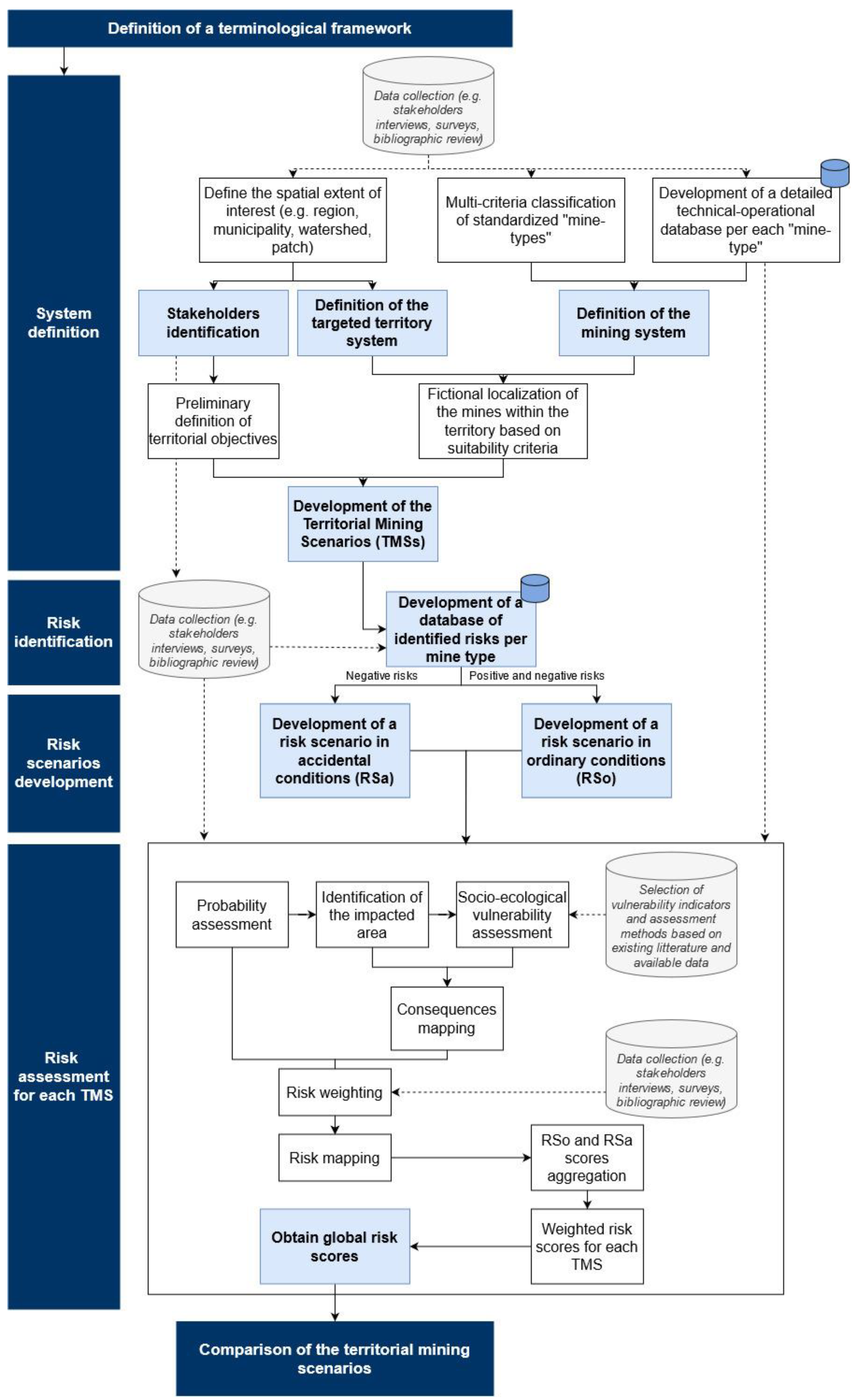
2. Methodological Framework and Initial Data

2.1. Methodological Framework

Figure 3 shows the methodological framework developed to operationalize the approach proposed in this study through different main steps.
Once the main initial data were gathered through literature review, interviews and field surveys, the boundaries of the study were defined through the characterization of a “territory system,” i.e., the socio-ecological system where mining is performed, and a “mining system,” which considers the different natures of mining projects in a given territory. This preliminary step allows the development of Territorial Mining Scenarios (TMSs). Each TMS represents a territorial strategy designed to meet specific predefined territorial objectives according to stakeholders (e.g., increase in employment or royalties related to mining, increase in mining production, reduction of land consumption or deforestation).
Risks were then identified, and two different risk scenarios were developed. A risk scenario under ordinary conditions (RSo) addressed a wide range of events related to the “normal” functioning conditions reasonably expected for a mine to fulfil its production goals. Such risks might have less important negative consequences but a higher probability of occurrence. The second risk scenario was an accidental one (RSa), which focused on the accidental events that may happen in a mine. These events have a lower probability of occurrence, but their negative consequences can be considerably higher for both the mine and for the territory.
Finally, the risk scenarios were assessed, combining the estimation of the probability of occurrence of a given risk event, as well as the assessment of the impacted areas and of the socio-ecological vulnerability of the studied territory. During this step, stakeholders’ perception were introduced through risk weighting coefficients. The risk scores were finally normalized and aggregated to compare each TMS.

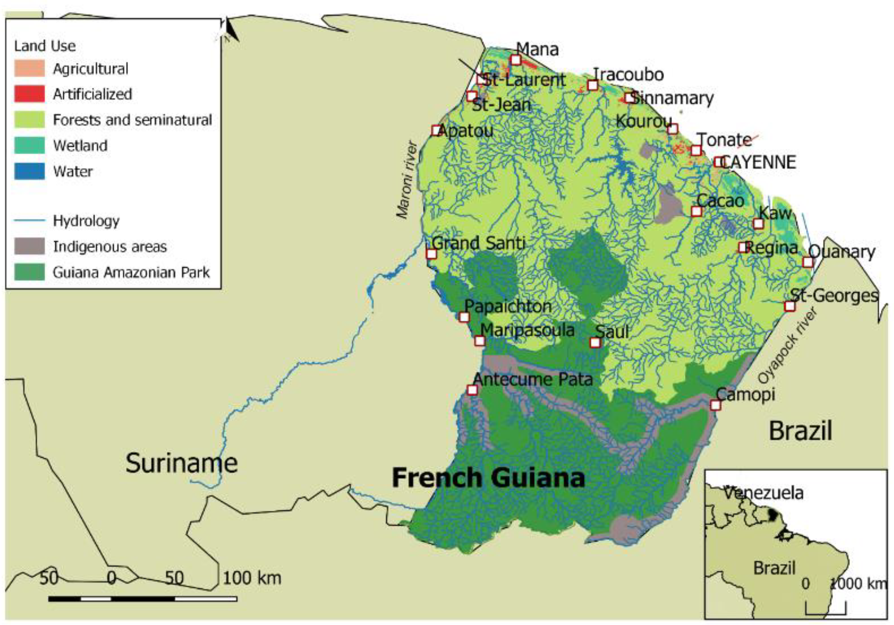
2.2. Initial Data Used

Data concerning mining risks and the associated stakeholders’ perceptions, mining project types and socio-ecological features of French Guiana were collected between the beginning of 2018 and 2020 through a bibliographic review, multiple field surveys, mining site visits and free interviews with local stakeholders. The involved stakeholders were members of public administration, mining operators and civil society). Collected data were semantic and/or spatialized, and their detailed descriptions are available in Supplementary Material File S1. Further data were gathered through the participation to the public debate for the Montagne d’Or project in April 2018 and used for risk identification. A significant amount of spatialized data was gathered from local authorities and mining operators to assess risks and the vulnerability of the area of interest. Data were used to identify characterize gold mining systems and the socio-ecological vulnerability of the study area, as well as to assess and weight mining risks.

3. Risk-Based Comparison of Territorial Gold Mining Scenarios in French Guiana

3.1. “Risk” Definition

To apply the approach proposed in this study, a methodological framework was developed (Figure 3). Its application involves six main steps, starting with the preliminary definition of a clear-cut vocabulary (Supplementary Material File S2). Hereafter, we refer to “risk” as to the positive and/or negative “effects of uncertainties on the objectives” of a system or a project [70]. Risk is a regime shift [71], a deviation from what is initially expected, and it depends on its probability of occurrence and the intensity of its consequences. The scale of the assessment depends on the scale at which such “objectives” are predefined. In the present study, the concept of risk is strictly related to the performances of both the mining project and the territory where it is located, since the nature and types of risks depend on whether and how the mine(s) contributes to the territorial objectives or may have an impact on them.

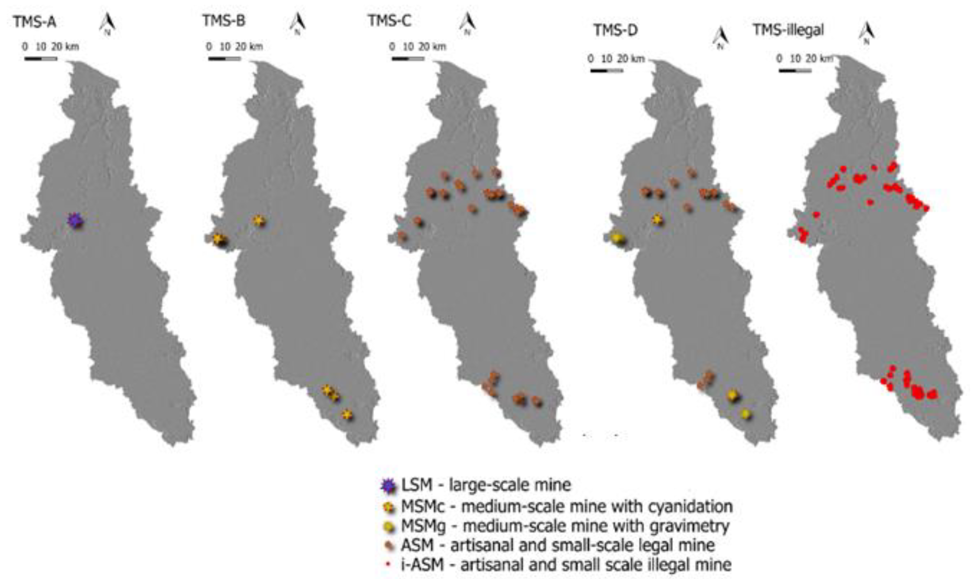
3.2. System Definition: The Territorial Mining Scenarios (TMSs)

3.2.1. The Territory System at the Watershed Level

Located just above the equator and covered by tropical rainforest, FG presents a high hydrographic density, making water management plans a priority in land planning. Therefore, this study focused on the watershed level, more precisely, at the scale of Mana River Basin (Figure 4a), which is sufficiently representative of the socio-ecological features of the whole territory. The Mana River Basin covers a surface of approximately 12,000 km2 with six main urban clusters. Its basin intersects the municipalities of Saint-Laurent du Maroni, Awala-Yalimapo, Mana and Saul. Among them, Mana and Saul are the only ones almost entirely located within the study area. Mana, with 11,300 inhabitants, is the fourth most important municipality in FG by surface (approximatively, 6300 km2), while Saul (less than 200 inhabitants) is an important ecological hotspot located in the middle of FG rainforest. Multiple areas of ecological importance (i.e., ZNIEFF), a RAMSAR zone, the biological reserve of Portal and a part of the Guiana Amazonian Park (GAP) are located in the area (Figure 4d). At the same time, one of the most important parts (more than 4000 km2) of the gold-enriched greenstone belt formation is located within the basin, which also explains the presence of more than 2000 illegal gold miners.
This territorial unit was characterized through the collection and production of multiple spatial data concerning its socio-ecological features (e.g., DEM, rainfall data, land-use, cadastral plans, water catchment points, population density, mining permits) (Figure 4b–d). These data were used to assess the socio-ecological vulnerability of the area through rule- and expert-based methods.

3.2.2. The Mine System: A “Mine-Type” Approach

Since a wide range of gold mining projects coexists in FG, the mining system is characterized through the utilization of gold “mine-types,” developed based on a multi-criteria classification already proposed by the authors of [40,72]. Four main categories of gold mines have been distinguished: (i) illegal artisanal and small-scale mining, which can involve the exploitation of both primary (hereafter called i-ASMp) or secondary (i-ASMs) gold deposits; (ii) legal artisanal and small-scale mining (ASM); (iii) legal medium-scale mining, in which gold can be recovered through gravimetry (MSMg) or cyanidation (MSMc); (iv) legal large-scale mining (LSM). The peculiar features of such types were detailed by the authors of [40].

3.2.3. Development of the TMSs

The characterization of both the territory and mine systems was performed to develop Territorial Mining Scenarios (TMS). As mentioned, TMSs represent territorial strategies designed to meet specific predefined territorial objectives defined among stakeholders. The TMSs were composed of a set of one or multiple mining projects in different numbers and/or types (i.e., the mine system), distributed across the area (i.e., the territory system, such as the Mana River Basin). The territory was characterized by its socio-ecological vulnerability according to existing available data, while FG gold mining activities were defined by their technical and operational specificities. For each gold mine type (presented in Section 3.2.2), a set of characteristics was defined (Table 1), derived from the list of specificities presented in the Supplementary Materials of [40].
In this study, a demonstrative example was presented by considering only one objective: a total gold production of approximately 5000 kg per year at the scale of the Mana watershed (Table 2), defined based on FG average production. Five TMSs were proposed, each being a combination of various gold mines of each type, with overall gold production meeting the mentioned objective (Table 2). For instance, 5000 kg Au/year can be produced alternatively by 1 LSM (TMS-A), 6 MSMc (TMS-B), 33 ASM (TMS-C) or, finally, in a mixed scenario, 20 ASM, 4 MSMg and 1 MSMc (TMS-D). An “illegal scenario” was designed as well, in which legal gold mining was assumed to be entirely absent. In this case, the achievement of the objective implies the presence of 758 i-ASM (TMS-illegal). These TMSs were compared based on the final scores of their respective accidental and ordinary risk scenarios.
The geographical expression of the TMSs implies that each mine in each TMS is spatially distributed through a GIS-based location, coupling geological (i.e., gold deposit map), juridical (i.e., authorized and forbidden areas for mining) and geotechnical suitability (i.e., slope inferior to 15%). Mine siting is fictional, which means that it is arbitrary and does not reflect the location of real mines. Fictional siting aims to highlight the prospective nature of the proposed approach, which proposes, ex ante, potential strategies for mining planning. The results of the localization of the gold mines for each TMS are presented in Figure 5.

3.3. Risk Identification and Development of the Risk Scenarios

The TMSs were compared based on the assessment of risk scenarios associated with different operating conditions of the mine. The risk scenarios were developed after a thorough process where risks were identified for each gold mine-type based on various sources (e.g., bibliographic review, stakeholders’ interviews, participation to public debates, mine field visits). The identified risks were grouped in two databases: a first database, related to the worldwide historical accidents in the mining sector. and a second database, specifically related to gold mining in FG and synthetized by the authors of [40].
For each TMS, two risk scenarios were considered (Table 3). A risk scenario under ordinary conditions (RSo) addressed a wide range of events related to the “normal” functioning conditions of a mine. In this study, we considered both positive and negative risks, such as gold supply, direct jobs opportunities, the expansion of social infrastructures, the support to local education, research and skill development and landscape degradation. The second risk scenario was an accidental one (RSa). The main central event chosen in this paper for the RSa was a tailings dam failure, one of the major concerns related to mining [74]. It is among the most reported accidents that has historically occurred in the mining sector, and it can have a wide range of consequences (e.g., social-, environmental-, health-related) [74,75,76,77,78]. Overtopping is the chosen failure mechanism, as it is one of the most common triggering events increasingly reported [79]. We considered approximatively one dozen negative consequences generated by the dam failure, such as the flood impact on local population, health risks, destruction of public infrastructures and water and soil degradation (Table 3).

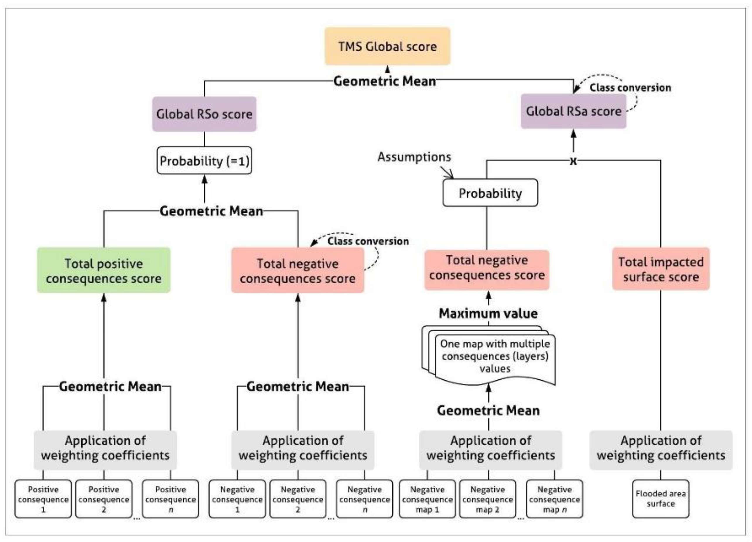
3.4. Risk Assessment and Final TMS Scoring

The quantification of the level of risk in the RSa and RSo aims to obtain final risk scores that will be combined for each TMS. Successively, The assessment process (Figure 6) involves: (i) the estimation of the probability of occurrence of the risk events; (ii) the identification of the total areas affected by the event in each TMS, according to the specific features of each corresponding mine-type; (iii) the assessment of socio-ecological vulnerability of the territory system through consequence-indicators (see Supplementary Material File S2) provided in Table 3; (iv) the combination of all these elements to obtain risk maps and risk scores. The RSa and RSo risk scores were then combined to obtain a final global score for each TMS, expressed on a range from 1 (high negative risk strategy) to 5 (low negative risk strategy). The following sub-sections focus particularly on the RSa assessment.

3.4.1. Probability Estimation

Probability assessment of tailings dam failures can be performed through multiple tools and methods requiring important amounts of data and processing time [78]. Because it was not the main focus of this study, the probability estimation was based on a simple four-class scale where 0.25 indicates “moderate probability of failure,” 0.5 indicates “even chance,” 0.75 indicates “expected failure” and 1 indicates “certain failure.” In this study, probability was assumed only according to the size of each gold mine type: the larger the gold mine type in size, productivity and financial resources, the better the safety measures potentially implemented to prevent the failure. In the RSo, the occurrence was assumed to be always equal to 1, which means that the event is unavoidable (Table 4).

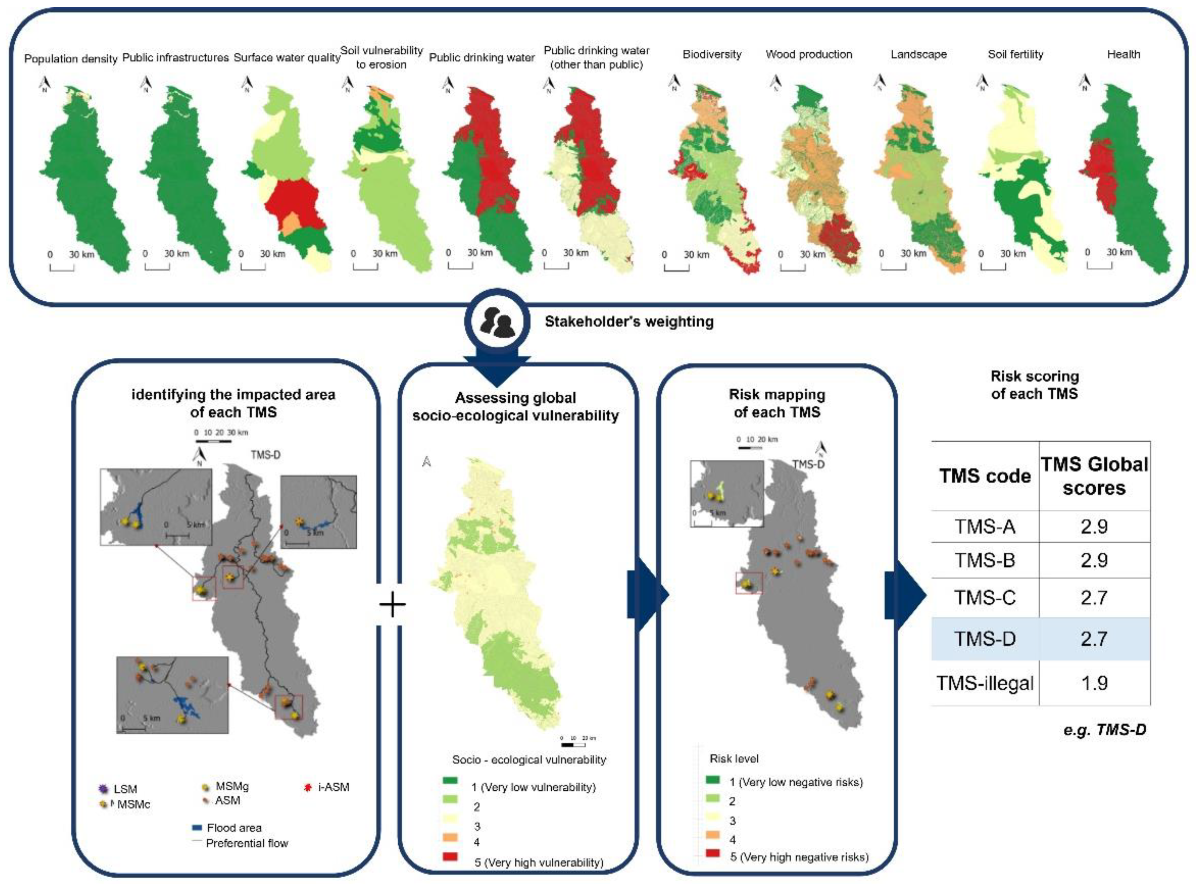
3.4.2. Identification of the Impacted Area(s)

The methods to assess and map tailings dam failure-induced flooded areas are widely diversified [83,84]. The total areas affected by a tailings dam failure in each TMS were here identified according to the combination of two simple methods. The first method [79,85] estimates the maximal extent of a mining dam failure-induced flood using only terrain data, the height of the mining dam and the capacity of the storing pond. The method uses an algorithm updated from the empirical equations proposed by the authors of [76], based on historical dam failure accident data. To our knowledge, it is the only method specifically developed for tailings dam failures found in the literature to date and which allows for the estimation of flooded areas for multiple coexistent mines at broad spatial extents. Because of its coarse outputs, this method was combined with a second method based on existing GIS-based modules (e.g., Maximum Flow Path Length from SAGA GIS) that aims at identifying direction and flow accumulation areas of the flood according to terrain data (Figure 7). A score between 1 and 5 was attributed to each TMS according to the surface of the affected areas (Table 5).
The highly impacted areas were attributed to the large-scale mining scenario (TMS-A) followed by the illegal and the medium-scale scenarios (Table 5). Nevertheless, such surfaces should be weighted with the probability at which the area is actually impacted, which may be less important for the TMSs A and B. In any case, further assessments should be performed with specific models to precisely estimate the potential flooded area and its probability of occurrence.

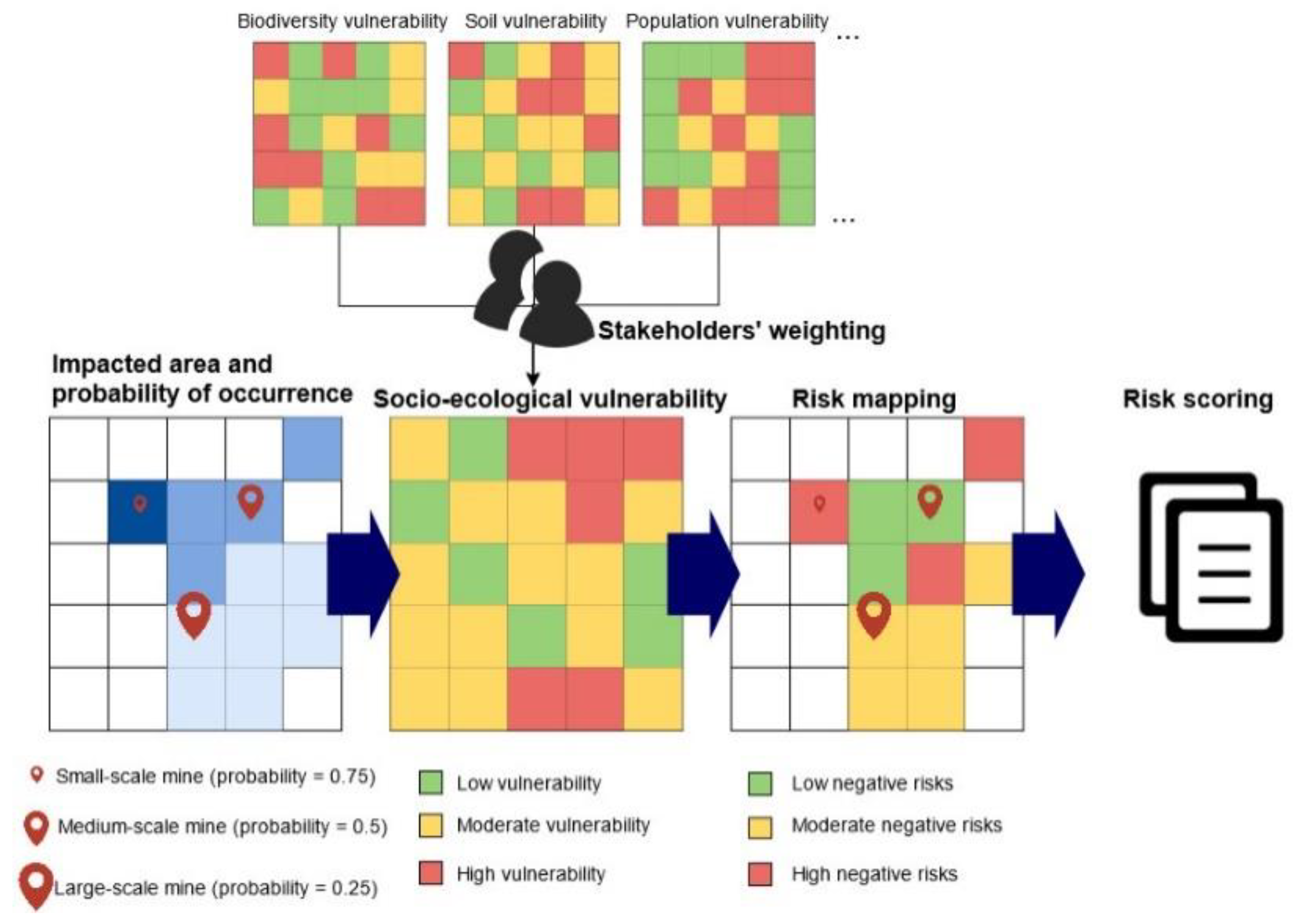
3.4.3. Socio-Ecological Vulnerability Assessment

Socio-ecological vulnerability is given by the intrinsic properties of the socio-ecological system that create its susceptibility to be positively or negatively affected by uncertain events. The vulnerability of the Mana River Basin was assessed through consequence indicators, which were selected through a bibliographic review and are presented in Table 3. Some of the indicators listed in Table 3 may be expressed in terms of the ecosystem services supply, particularly concerning provisioning (e.g., drinking water supply, crop and wood production), regulating (e.g., run-off and erosion, water quality) and cultural (e.g., landscape degradation) services. Each consequence indicator was assessed according to existing methods or, whenever necessary, according to methods specifically designed upon available data for the studied area. For instance, the vulnerability of the watershed in terms of drinking water provisioning (other than public) was assessed reclassifying the scores given by a report from the Regional Health Agency [82]. For each consequence, a range of thresholds and vulnerability scores from 1 to 5 was defined (Figure 7).
In some cases, expert-based frameworks were specifically developed to quantitatively or qualitatively assess the selected consequences depending on both semantic and spatially explicit available data. For instance, population vulnerability was estimated based on reclassified land-use types and population density (Supplementary Material File S3). Soil fertility and erodibility were assessed based on simplified soil maps at the 1,000,000 scale [86] and semantic field-data related to FG soils available in various reports [87,88] and [Supplementary Material File S3]. The final scores obtained were then rescaled and converted to a range from 1 (low vulnerability, and thus, lower potential negative consequences) to 5 (higher vulnerability and thus, higher potential negative consequences) (Figure 7).

3.4.4. Risk Weighting according to Stakeholders’ Perception

The integration of stakeholders within the assessment of the TMSs might provide insights into further experience, local knowledge and model acceptance [89]. For such reasons, weighting coefficients based on stakeholders’ risk perception were integrated within the assessment before the final global score. A semi-structured questionnaire composed of 13 questions was developed and distributed in early 2020 among local stakeholders (i.e., mining operators, public administrators, civil society). Of the 39 questionnaires returned at this stage, only 34 were completed and acceptable to calculate the weighting scores. Although the number of answers is statistically irrelevant, we decided to integrate this step into the study to present the full application of the proposed approach.
Respondents noted their perceived relevance of various socio-ecological assets potentially positively and negatively impacted by gold mining (e.g., drinking water, public infrastructures, population safety and health, biodiversity) on a scale between 0 and 4. The results were provided under the form of scores, rescaled between 0 and 1 (Supplementary Material File S4) according to Equation (1).
W = v m i n m a x m i n
where W is the normalized weighting coefficient between 0 and 1, v is the actual score given by each respondent on a scale from 0 to 4 in the original survey, min is the minimum value of the non-normalized score (i.e., in this case, 0), and max is the maximal value of the non-normalized score (i.e., in this case, 4). The socio-ecological vulnerability map was hence the result of the assessments performed in Section 3.4.4 and the application of the weighting coefficients here developed.

3.4.5. Estimation of Risk Scores and Final TMS Global Scores

Figure 8 highlights the main data aggregation steps and methods used to obtain (1) the scores of each risk scenario and (2) the TMS global scores. The scores were combined mainly using the geometric mean, which is often preferred when synthesizing judgment for decision-making purposes [90].
The last step of the framework involved the combination of the two risk scenario scores to obtain the final global TMS score. The TMS scores were assessed on a range from 1 to 5, where the higher the score, the lesser the final negative risk level of the TMS. As shown in Table 6, TMS-B and TMS A presented the higher scores, followed by TMSsC, D and finally, the illegal scenario, with the worst global risk score.

4. Discussion and Operational Implications

4.1. The Application of Standardized “Mine-Types” within Territorial Scenarios

The proposed approach represents a prospective analysis that, through creating a scenario, focuses on the diagnostic phase prior to decision-making in land planning. The development of the Territorial Mining Scenarios (TMSs), and their risk-based comparison confirm and strengthen its prospective dimension. Indeed, creating a scenario aims to represent future strategies through the proposition of a range of potential land-use choices [91]. The scenario-based approach proposed by this study implies alternative options resulting from the combination of both technical operational characteristics related to the mining sphere, testing the classification proposed by the authors of [40]. In addition, the proposed approach tests the features of the socio-ecological systems where mining is performed, as shown in Figure 7. Concerning the first alternative options, the use of mine-types was proven to be a key tool in creating a scenario. The mine-type classification is therefore a prior baseline step to apprehend and detail the “mining system” and its technical and operational features. Despite the classification focuses on the features of each mine-type, the assessment itself is performed through a systemic sector-based approach, which overcomes the consideration of the mine—within land planning—as a standalone object, considering its vertical variability, unlike common land-use approaches. For instance, a similar approach was proposed by the authors of [92], who assessed the level of different risk scenarios applied to various existing gold mine sites in Ecuador. However, the use of “mine-types” would integrate a higher level of technical and operational detail and, at the same time, support prospective assessments over broader spatial extents involving multiple strategies for both interventions from a land planning and industrial management perspectives. Finally, the development of mine-types should give also peculiar attention to the technical and organizational measures implemented by mining operators to improve project performances, limiting risk events from occurring (i.e., proactive safety measures) and/or reducing their consequences once they occur (i.e., reactive safety measures) [93]. For instance, technical and organizational measures in tailings dam management can be proactive (e.g., overflow devices and spillway systems, dry disposal of the tailings, vegetation covers, freeboard control; monitoring and visual inspections, crisis simulation trainings) and reactive (e.g., emergency water ponds, alarm systems, containment barriers; insurances and evacuation measures). For the risk assessment to be reliable, the capability of each mining project to implement safety and remediation measures must be identified and quantitively accounted for. These measures are only quantitatively accounted during probability estimation based on expert-based scores. However, they may completely alter the final scores of each TMS. Approaches such as the Bow-Tie analysis [94] could facilitate their integration in the assessment when designing the risk scenarios for each TMS.
Finally, feedback loops should be more pertinently accounted for in order to consider the risks affecting the mining operators themselves. This would be an interesting driver to help project managers to enhance socio-ecological performances and, finally, to avoid social and business costs for the enterprise.

4.2. Data Availability: A Specific Focus on Illegal Gold Mining

The main challenge of creating a scenario is data availability. Data availability and uncertainty represent basic but fundamental issues, especially in data-limited environments and sparsely populated areas [31,95,96], and when the assessment process switches across multiple spatial scales, implying the need of spatial precision requirements [97].
This is the case in FG, where the difficulty of access on the whole territory limits available data or drives extrapolation processes that provide coarse data at the territory level. For instance, dense soil surveys are often limited to the littoral area, which is the easiest to access, while soil resources of the inner regions are predicted based on punctual and coarser information. Socio-economic and anthropological data may also be harder to obtain as they imply surveys among a wide range of populations, sometimes confined in inner forest regions and with different values and social codes.
Concerning gold mining, particular attention should be given to illegal and informal gold mining, which is regarded as a worldwide challenge [98] for mining and socio-environmental regulatory frameworks [99]. Focusing on the analysis of illegal gold mining related data, the authors of [96] suggested that the central problem in FG is the information marginalization and the qualification of the data, which is never raw and is accentuated by the difficulties in accessing to the field.
Indeed, the great variability, volatility and rapid changes of illegal gold mining in terms of techniques and extraction methods, but also in terms of social structures and productivity, could pose a significant challenge for the definition of mining policies [98,100]. Nevertheless, authors have suggested that sustainable performances could be applied to this sector for the creation of better living conditions in communities facing social, environmental and economic disruptions [100,101]. For instance, the authors of [102] proposed a neat distinction between illegal “invasive” mining from “community-based” informal mining, with considerable diverse implications from a regulatory point of view.
Annual production rates of illegal gold mining vary significantly from one country to another and from site to site [98]. Furthermore, the very notion of mine site cannot be applied to such activities, and it is difficult to determine where a mine site ends and another begins. Therefore, the application of “mine-types,” developed by the authors of [40] and applied here, should be reviewed and/or adapted to such peculiar activities. The first step would be the collection of the main characteristics of these operations and extensive field surveys, for instance, through related works focusing on the neighboring illegal gold mining system in the Amazon [103,104,105].

4.3. Temporal Variability of the TMSs

The temporal dynamics related both to the mining and territory systems have a significant influence on risk level and on the current choice and adaptability of pertinent land-planning strategies in the long term. Changes and variations in values and vulnerability of both the mining and territory systems [106] should be accounted for through a double temporal dimension. The first temporal dimension should be related to the mining system, and it might concern mining phasing or the evolution of mining techniques and technologies [107,108]. Temporal variability related to mining phasing concerns the risks related to prospecting, planning, operation and closure activities in order to support the management of landscapes particularly affected by past mining activities, using, for instance, 2D or 3D modeling techniques as suggested by the authors of [109]. Furthermore, the evolution of mining activities in time implies, for instance, the development of new extraction or recovery techniques that might impose the definition of new “mine-types” and updating existing classifications [40]. For instance, artisanal and industrial underground gold mining is currently gaining prominent interest among FG mining operators and local authorities, who are analyzing the feasibility of such techniques in terms of financial viability and socio-environmental risks. The second temporal dimension concerns the variability in time of the characteristics of the territory in which mining is performed. Therefore, creating a scenario should also involve alternatives where the socio-ecological parameters vary (e.g., demographic growth and urban intensification, land use changes, new environmental protection measures, climate change effects), driving, for instance, changes in the ecosystem services supply [8]. As mentioned, this is particularly important in FG where gold mining techniques are evolving, the population is expected to double in the next decades [110] and climate change impacts may exacerbate gold mining-related risks [111].

4.4. Stakeholder Involvement: From the Territorial Objectives to the Comparison of the Scenarios

The scenarization process here proposed depends on the prior definition of objectives fixed at the territory level that should orientate future land-planning strategies to meet sustainable development performances. Despite the consideration of only one objective (gold production) in the feasibility test presented in this article, the territorial objectives leading to the proposition of TMSs must be decided through the involvement of all stakeholders to converge divergent narratives on how to develop a territory and the use of its resources. This implies actions and processes which pertain to the sociopolitical sphere rather than the scientific one but that play a pivotal role in the decision-making process, (i.e., how, by and for whom the decision is taken). Several authors have focused on the participative dimension in system modeling and decision-making [89,112,113,114], and an optimal definition of territorial objectives could be possible through the implementation of multiple collaborative tools with local stakeholders (e.g., discussion panels, round tables, surveys, workshops) or existing decision-making tools (e.g., Analytical Hierarchy Process, ELECTRIII, TOPSIS) [65,66,67,68,69,115,116,117] and participative and automated GIS-based processes [118,119]. For instance, stakeholders should also be involved in the selection and ranking of risk indicators and weighting criteria. This would be a prior measure to tackle the shortcomings within the mining sector to meet SDGs [120].

4.5. Geospatial Issues and the Transboundary Dimension of Risks

The spatial dimension of the TMS brings forth a series of challenges in risk assessment processes, mainly concerning scale effects and uncertainty of input data and results, particularly when dealing with multiple scales [121,122]. Input data must have a spatial precision that fits the chosen operational and jurisdictional level of action (i.e., the territory vs the mining project) in terms of scale and/or resolution (i.e., the “grain”) [122,123]. Furthermore, risks do not submit to administrative boundaries, and their consequences or triggering factors might go beyond the limits of a given territory. Because of its specific location and features, FG is a highly permeable territory separated from Suriname and Brazil by the Maroni and Oyapock rivers (Figure 2). Moreover, the socio-ecological processes of FG may overcome administrative boundaries. For instance, the Maroni River Basin is split in half between FG and Suriname (Figure 4a). Here, industrial gold mines, as well as illegal mines, are closer to FG than to Surinamese villages, leading to a various range of exogenous impacts (e.g., water pollution, silting) on FG communities [32]. New mining techniques not currently allowed in FG, such as gold dredging, are sometimes performed outside of FG [124,125]. This technique involves dredges that extract gold from sand, gravel and dirt, representing a supplementary mine-type with specific risks. Finally, this geographic permeability drives a widespread presence of illegal gold miners that move across Brazil, FG and Suriname, inserting FG in transnational dynamics that cover the whole Amazonian basin and the Guiana Shield [126]. Neglecting such dynamics would be regrettable for governance perspectives, and limitations in transboundary risk management may have important consequences on global and local sustainability strategies [127,128].

4.6. Sustainability and Georesources: Toward Cross-Disciplinary Frameworks to Support Decision-Making

Geoscience is at the very foundation of sustainability, and it can enable economic growth, human development and environmental protection [129]. Nevertheless, sustainable thinking within the mining sector could be further improved through the integration of existing cross-disciplinary frameworks. This is especially urgent in the informal and illegal sectors, which are at the crossroad between subsistence and where sustainability performances do not depend on “corporation requirements” [99]. Such frameworks should consider both the diversity and functionality of geo-resources, as well as the different range of needs they might fulfill and the socio-ecological vulnerability of their location. This is particularly true for territories such as FG where: (i) conservation and protection interests of natural forested areas face rapid and significant land use changes due to population growth with the consequent development of related infrastructures and various activities transforming natural landscapes, and (ii) ecosystems support local economies and livelihoods but also have global impacts. Therefore, mining activities should be integrated within interdisciplinary approaches to analyze their footprint on the territory and guide policy responses in terms of land planning [130,131]. As a part of territorial management, mining is a transversal object.

5. Conclusions

Productivity goals related to immediate human needs such as the supply of raw materials and mineral commodities, significantly affect socio-environmental sustainability. Nevertheless, the integration of sustainable development performances within the mining sector led to the enhancement and discussion of the role of mining activities for the achievement of socio-environmental standards such as the SDGs. Because of its territorial footprint, characterized by a wide range of positive and negative risks that exceed the mine site itself, a mine represents a matter of land-planning. Based on such paradigm, the approach proposed in this study was developed and tested on the case of gold mining in FG. The proposed approach shows that mining activities can be integrated in a cross-disciplinary scenario-based analysis at the territory level through the development of a “Territorial Mining Scenario,” as alternative strategies to support sustainable governance of mining regions. The very notion of a “mining project” and its characterization find its place within a given socio-ecological system with specific features and vulnerabilities.
Although no decisions could be based upon this framework at this stage, the proposed approach proved to be feasible, allowing a territorial analysis on mining and the comparison of potential planning strategies. Multiple challenges still need to be accomplished. In addition, it is necessary to apply such approaches to other case studies—in terms of commodities and territories—to assure better reliability, adaptability, and stakeholder involvement and operationalization for decision-making support. Nevertheless, this first study shows what can be performed when different aspects related to mining are transversally tied altogether within a holistic approach where geosciences and human and social sciences converge to support sustainable public policies and management strategies of mining regions.

Supplementary Materials

The following supporting information can be downloaded at: https://www.mdpi.com/article/10.3390/su141710476/s1. Supplementary Materials File S1. Table S1. Main Dataset used in this study. The table involve mostly the spatial data obtained during the research. The detailed sources can be found in [84]. Supplementary Materials File S2. Table S2. List and definitions of the terms involved in the proposed framework. The list of the references supporting the definition are detailed in [84]. Supplementary Materials File S3: Simplified flowsheets of the methodologies developed for the assessment of socio-ecological vulnerability at the Mana river basin scale, based on the available data. Figure S3.1. Flowsheet of the methodology developed for the assessment of population vulnerability based on land-use and demographic data. Figure S3.2. Flowsheet of the methodology developed for the assessment of building vulnerability based on builinds-related data concerning their concentration per polygon and their destination of use (e.g., residential, monuments, public offices). Figure S3.3. Flowsheet of the methodology developed for the assessment of soil ecosystem services vulnerability based on semantic and spatialized data. Supplementary Materials File S4: Socio-ecological assets evaluated in the questionnaire survey and the corresponding consequences associated. On the last two columns on the right, the weighting coefficients derived from all the complete answers (Wgen), or from the respondents belonging to the “civil society” (Wcs) and “public administration” (Wpa) categories.

Author Contributions

The article is the result of a 3-year PhD realized by O.S. and supervised by Y.G. and R.M. The article was written by O.S. and futherly corrected and modified by O.S., R.M. and Y.G. All authors have read and agreed to the published version of the manuscript.

Funding

This work was supported by the French National Research Agency (ANR) through the national program “Investissements d’avenir” (ANR-10-LABX-21–01/LABEX RESSOURCES21).

Institutional Review Board Statement

Not applicable.

Informed Consent Statement

Informed consent was obtained from all subjects involved in the study during the questionnaire survey to weight gold mining related risks and socio-ecological vulnerability. The questionnaire was anonymous.

Data Availability Statement

Not applicable.

Acknowledgments

This work was supported by the French National Research Agency (ANR) through the national program “Investissements d’avenir” (ANR-10-LABX-21–01/LABEX RESSOURCES21) and realized at the Georessources laboratory (Université de Lorraine).

Conflicts of Interest

The authors declare no conflict of interest.

References

  1. Moors, E.H.; Mulder, K.F.; Vergragt, P.J. Towards cleaner production: Barriers and strategies in the base metals producing industry. J. Clean. Prod. 2005, 13, 657–668. [Google Scholar] [CrossRef]
  2. Aznar-Sánchez, J.A.; Velasco-Muñoz, J.F.; Belmonte-Ureña, L.J.; Manzano-Agugliaro, F. Innovation and technology for sustainable mining activity: A worldwide research assessment. J. Clean. Prod. 2019, 221, 38–54. [Google Scholar] [CrossRef]
  3. Blinova, E.; Ponomarenko, T.; Knysh, V. Analyzing the Concept of Corporate Sustainability in the Context of Sustainable Business Development in the Mining Sector with Elements of Circular Economy. Sustainability 2022, 14, 8163. [Google Scholar] [CrossRef]
  4. Mestanza-Ramón, C.; Mora-Silva, D.; D’Orio, G.; Tapia-Segarra, E.; Gaibor, I.D.; Parra, J.F.E.; Velásquez, C.R.C.; Straface, S. Artisanal and Small-Scale Gold Mining (ASGM): Management and Socioenvironmental Impacts in the Northern Amazon of Ecuador. Sustainability 2022, 14, 6854. [Google Scholar] [CrossRef]
  5. Amirshenava, S.; Osanloo, M. A hybrid semi-quantitative approach for impact assessment of mining activities on sustainable development indexes. J. Clean. Prod. 2019, 218, 823–834. [Google Scholar] [CrossRef]
  6. Schimann, H.; Petit-Jean, C.; Guitet, S.; Reis, T.; Domenach, A.M.; Roggy, J.-C. Microbial bioindicators of soil functioning after disturbance: The case of gold mining in tropical rainforests of French Guiana. Ecol. Indic. 2012, 20, 34–41. [Google Scholar] [CrossRef]
  7. Boldy, R.; Santini, T.; Annandale, M.; Erskine, P.D.; Sonter, L.J. Understanding the impacts of mining on ecosystem services through a systematic review. Extr. Ind. Soc. 2021, 8, 457–466. [Google Scholar] [CrossRef]
  8. Liu, S.; Liu, L.; Li, J.; Zhou, Q.; Ji, Y.; Lai, W.; Long, C. Spatiotemporal Variability of Human Disturbance Impacts on Ecosystem Services in Mining Areas. Sustainability 2022, 14, 7547. [Google Scholar] [CrossRef]
  9. Badri, A.; Nadeau, S.; Gbodossou, A. A mining project is a field of risks: A systematic and preliminary portrait of mining risks. Int. J. Saf. Secur. Eng. 2012, 2, 145–166. [Google Scholar] [CrossRef]
  10. Kemp, D.; Worden, S.; Owen, J.R. Differentiated social risk: Rebound dynamics and sustainability performance in mining. Resour. Policy 2016, 50, 19–26. [Google Scholar] [CrossRef]
  11. Nguyen, N.; Boruff, B.; Tonts, M. Mining, development and well-being in Vietnam: A comparative analysis. Extr. Ind. Soc. 2017, 4, 564–575. [Google Scholar] [CrossRef]
  12. Conde, M.; Le Billon, P. Why do some communities resist mining projects while others do not? Extr. Ind. Soc. 2017, 4, 681–697. [Google Scholar] [CrossRef]
  13. Aguilar-González, B.; Navas, G.; Brun, C.; Aguilar-Umaña, A.; Cerdán, P. Socio-ecological distribution conflicts in the mining sector in Guatemala (2005–2013): Deep rooted injustice and weak environmental governance. Extr. Ind. Soc. 2018, 5, 240–254. [Google Scholar] [CrossRef]
  14. Froese, R.; Pinzón, C.; Aceitón, L.; Argentim, T.; Arteaga, M.; Navas-Guzmán, J.S.; Pismel, G.; Scherer, S.F.; Reutter, J.; Schilling, J.; et al. Conflicts over Land as a Risk for Social-Ecological Resilience: A Transnational Comparative Analysis in the Southwestern Amazon. Sustainability 2022, 14, 6520. [Google Scholar] [CrossRef]
  15. Bergeron, K.M.; Jébrak, M.; Yates, S.; Séguin, C.; Lehmann, V.; Le Meur, P.-Y.; Angers, P.; Durand, S.; Gendron, C. Mesurer l’acceptabilité sociale d’un projet minier: Essai de modélisation du risque social en contexte québécois. Vertigo 2015, 15, 3. [Google Scholar] [CrossRef]
  16. Pokorny, B.; von Lübke, C.; Dayamba, S.D.; Dickow, H. All the gold for nothing? Impacts of mining on rural livelihoods in Northern Burkina Faso. World Dev. 2019, 119, 23–39. [Google Scholar] [CrossRef]
  17. Gorman, M.R.; Dzombak, D.A. A review of sustainable mining and resource management: Transitioning from the life cycle of the mine to the life cycle of the mineral. Resour. Conserv. Recycl. 2018, 137, 281–291. [Google Scholar] [CrossRef]
  18. Azapagic, A. Developing a framework for sustainable development indicators for the mining and minerals industry. J. Clean. Prod. 2004, 12, 639–662. [Google Scholar] [CrossRef]
  19. McLellan, B.; Corder, G.; Giurco, D.; Green, S. Incorporating sustainable development in the design of mineral processing operations—Review and analysis of current approaches. J. Clean. Prod. 2009, 17, 1414–1425. [Google Scholar] [CrossRef]
  20. Falck, W.E.; Spangenberg, J.H. Selection of social demand-based indicators: EO-based indicators for mining. J. Clean. Prod. 2014, 84, 193–203. [Google Scholar] [CrossRef]
  21. Lechner, A.M.; McIntyre, N.; Witt, K.; Raymond, C.M.; Arnold, S.; Scott, M.; Rifkin, W. Challenges of integrated modelling in mining regions to address social, environmental and economic impacts. Environ. Model. Softw. 2017, 93, 268–281. [Google Scholar] [CrossRef]
  22. Mancini, L.; Sala, S. Social impact assessment in the mining sector: Review and comparison of indicators frameworks. Resour. Policy 2018, 57, 98–111. [Google Scholar] [CrossRef]
  23. Zvarivadza, T. Artisanal and Small-Scale Mining as a challenge and possible contributor to Sustainable Development. Resour. Policy 2018, 56, 49–58. [Google Scholar] [CrossRef]
  24. GRI. G4-Mining-and-Metals-Sector-Disclosures; Global Reporting Initiative: Amsterdam, The Netherlands, 2013. [Google Scholar]
  25. ACSMP, Australian Centre for Sustainable Mining Practices; Department of Industry; Innovation and Science. A Guide to Leading Practice Sustainable Development in Mining; Department of Resources, Energy and Tourism: Canberra, Australia, 2011.
  26. UNDP; UN Environment. Managing Mining for Sustainable Development: A Sourcebook; United Nations Development Programme: Bangkok, Thailand, 2018. [Google Scholar]
  27. Dragomir, V.D. How do we measure corporate environmental performance? A critical review. J. Clean. Prod. 2018, 196, 1124–1157. [Google Scholar] [CrossRef]
  28. Lèbre, É.; Owen, J.R.; Corder, G.D.; Kemp, D.; Stringer, M.; Valenta, R.K. Source Risks as Constraints to Future Metal Supply. Environ. Sci. Technol. 2019, 53, 10571–10579. [Google Scholar] [CrossRef]
  29. Millennium Ecosystem Assessment. Ecosystems and Human Well-Being: Synthesis; World Resources Institute, Island Press: Washington, DC, USA, 2005. [Google Scholar]
  30. Rao, Y.; Zhou, M.; Ou, G.; Dai, D.; Zhang, L.; Zhang, Z.; Nie, X.; Yang, C. Integrating ecosystem services value for sustainable land-use management in semi-arid region. J. Clean. Prod. 2018, 186, 662–672. [Google Scholar] [CrossRef]
  31. Le Tourneau, F.-M. Sparsely populated regions as a specific geographical environment. J. Rural Stud. 2020, 75, 70–79. [Google Scholar] [CrossRef]
  32. Sieber, I.M.; Campagne, C.S.; Villien, C.; Burkhard, B. Mapping and assessing ecosystems and their approach to ecosystem service supply in Suriname and French Guiana. Ecosyst. People 2021, 17, 148–164. [Google Scholar] [CrossRef]
  33. Galochet, M.; Morel, V. La biodiversité dans l’aménagement du territoire en Guyane française. Vertigo 2015, 15, 1. [Google Scholar] [CrossRef]
  34. Aubertin, C.; Pons, S. Politiques de développement durable en Guyane: Souveraineté sur les ressources forestières. Territ. Mouv. 2017, 36. [Google Scholar] [CrossRef]
  35. Scammacca, O.; Bétard, F.; Aertgeerts, G.; Heuret, A.; Fermet-Quinet, N.; Montagne, D. Geodiversity Assessment of French Guiana: Challenges and Implications for Sustainable Land Planning. Geoheritage 2022, 14, 83. [Google Scholar] [CrossRef]
  36. De Santi Vincent Pommier, PhD thesis, Determinants of Malaria among French armed Forces Involved in Military Operation to Control and Reduce Illegal Gold Mining in French Guiana, Thèse de Doctorat en Santé, Université de Guyane. 2017. Available online: https://tel.archives-ouvertes.fr/tel-01831945 (accessed on 4 September 2020).
  37. Rossi, V.; Dolley, T.; Cornu, G.; Guitet, S.; Hérault, B. Guyasim: Un outil d’aide à la décision pour l’aménagement d’un territoire forestier, la guyane. Bois Forets Des. Trop. 2015, 326, 67. [Google Scholar] [CrossRef]
  38. Sanlaville, M.; Salles, J.M. Bilan Activité 2 Du Projet GuyaSim: Scénarios Socio-économiques Et Dynamiques Territoriales De La Guyane. Rapport Technique; Cirad Guyane: Kourou, France, 2012; p. 46. [Google Scholar]
  39. Jébrak, M.; Heuret, A.; Rostan, P. The gold, peoples and multiple frontiers of French Guiana. Extr. Ind. Soc. 2020, 8, 8–22. [Google Scholar] [CrossRef]
  40. Scammacca, O.; Gunzburger, Y.; Mehdizadeh, R. Gold mining in French Guiana: A multi-criteria classification of mining projects for risk assessment at the territorial scale. Extr. Ind. Soc. 2021, 8, 32–43. [Google Scholar] [CrossRef]
  41. Camino. Available online: https://camino.beta.gouv.fr/ (accessed on 1 December 2021).
  42. Grand Débat Avec les Maires d’Outre-Mer, 4 Février 2019. Available online: https://youtu.be/D5uKwFGcUBc (accessed on 9 October 2020).
  43. Orea, Mine Responsable, Présentation Institutionnelle, Août 2020. Available online: https://oreamining.com/ (accessed on 2 September 2021).
  44. Tixier, J.; Dusserre, G.; Salvi, O.; Gaston, D. Review of 62 risk analysis methodologies of industrial plants. J. Loss Prev. Process Ind. 2002, 15, 291–303. [Google Scholar] [CrossRef]
  45. Suopajärvi, L. Social impact assessment in mining projects in Northern Finland: Comparing practice to theory. Environ. Impact Assess. Rev. 2013, 42, 25–30. [Google Scholar] [CrossRef]
  46. Gałaś, S.; Gałaś, A. The qualification process of mining projects in environmental impact assessment: Criteria and thresholds. Resour. Policy 2016, 49, 204–212. [Google Scholar] [CrossRef]
  47. Verma, S.; Chaudhari, S. Highlights from the literature on risk assessment techniques adopted in the mining industry: A review of past contributions, recent developments and future scope. Int. J. Min. Sci. Technol. 2016, 26, 691–702. [Google Scholar] [CrossRef]
  48. Hresc, J.; Riley, E.; Harris, P. Mining project’s economic impact on local communities, as a social determinant of health: A documentary analysis of environmental impact statements. Environ. Impact Assess. Rev. 2018, 72, 64–70. [Google Scholar] [CrossRef]
  49. Clark, M.R.; Durden, J.M.; Christiansen, S. Environmental Impact Assessments for deep-sea mining: Can we improve their future effectiveness? Mar. Policy 2019, 114. [Google Scholar] [CrossRef]
  50. Castilla-Gómez, J.; Herrera-Herbert, J. Environmental analysis of mining operations: Dynamic tools for impact assessment. Miner. Eng. 2015, 76, 87–96. [Google Scholar] [CrossRef]
  51. Franks, D.M.; Brereton, D.; Moran, C.J. The cumulative dimensions of impact in resource regions. Resour. Policy 2013, 38, 640–647. [Google Scholar] [CrossRef]
  52. Crawley, D.; Aho, I. Building environmental assessment methods: Applications and development trends. Build. Res. Inf. 1999, 27, 300–308. [Google Scholar] [CrossRef]
  53. Cashmore, M.; Gwilliam, R.; Morgan, R.; Cobb, D.; Bond, A. The interminable issue of effectiveness: Substantive purposes, outcomes and research challenges in the advancement of environmental impact assessment theory. Impact Assess. Proj. Apprais. 2004, 22, 295–310. [Google Scholar] [CrossRef]
  54. Jay, S.; Jones, C.; Slinn, P.; Wood, C. Environmental impact assessment: Retrospect and prospect. Environ. Impact Assess. Rev. 2007, 27, 287–300. [Google Scholar] [CrossRef]
  55. Jiskani, I.M.; Cai, Q.; Zhou, W.; Lu, X. Assessment of risks impeding sustainable mining in Pakistan using fuzzy synthetic evaluation. Resour. Policy 2020, 69, 101820. [Google Scholar] [CrossRef]
  56. Jiskani, I.M.; Cai, Q.; Zhou, W.; Lu, X.; Shah, S.A.A. An integrated fuzzy decision support system for analyzing challenges and pathways to promote green and climate smart mining. Expert Syst. Appl. 2021, 188, 116062. [Google Scholar] [CrossRef]
  57. Jiskani, I.M.; Moreno-Cabezali, B.M.; Rehman, A.U.; Fernandez-Crehuet, J.M.; Uddin, S. Implications to secure mineral supply for clean energy technologies for developing countries: A fuzzy based risk analysis for mining projects. J. Clean. Prod. 2022, 358. [Google Scholar] [CrossRef]
  58. Awuah-Offei, K.; Adekpedjou, A. Application of life cycle assessment in the mining industry. Int. J. Life Cycle Assess. 2010, 16, 82–89. [Google Scholar] [CrossRef]
  59. Loiseau, E.; Aissani, L.; LE Feon, S.; Laurent, F.; Cerceau, J.; Sala, S.; Roux, P. Territorial Life Cycle Assessment (LCA): What exactly is it about? A proposal towards using a common terminology and a research agenda. J. Clean. Prod. 2018, 176, 474–485. [Google Scholar] [CrossRef]
  60. Durucan, S.; Korre, A.; Munoz-Melendez, G. Mining life cycle modelling: A cradle-to-gate approach to environmental management in the minerals industry. J. Clean. Prod. 2006, 14, 1057–1070. [Google Scholar] [CrossRef]
  61. Farjana, S.H.; Huda, N.; Mahmud, M.P.; Saidur, R. A review on the impact of mining and mineral processing industries through life cycle assessment. J. Clean. Prod. 2019, 231, 1200–1217. [Google Scholar] [CrossRef]
  62. Pillai, A.; Joshi, A.; Rao, K. Performance measurement of R&D projects in a multi-project, concurrent engineering environment. Int. J. Proj. Manag. 2002, 20, 165–177. [Google Scholar] [CrossRef]
  63. De Maio, A.; Verganti, R.; Corso, M. A multi-project management framework for new product development. Eur. J. Oper. Res. 1994, 78, 178–191. [Google Scholar] [CrossRef]
  64. Olsson, R. Risk management in a multi-project environment. Int. J. Qual. Reliab. Manag. 2008, 25, 60–71. [Google Scholar] [CrossRef]
  65. Cluett, J.D. Network Africa—A Complex System; Xlibris Corporation: Bloomington, Indiana, 2012. [Google Scholar]
  66. Neagu, C.; Bulearca, M.; Sima, C.; Mărguş, D. A SWOT Analysis of Romanian Extractive Industry and Re-industrialization Requirements of this Industry. Procedia Econ. Financ. 2015, 22, 287–295. [Google Scholar] [CrossRef]
  67. Wu, P.; Zhao, G.; Li, Y. Green Mining Strategy Selection via an Integrated SWOT-PEST Analysis and Fuzzy AHP-MARCOS Approach. Sustainability 2022, 14, 7577. [Google Scholar] [CrossRef]
  68. Azimi, R.; Yazdani-Chamzini, A.; Fouladgar, M.M.; Zavadskas, E.K.; Basiri, M.H. Ranking the strategies of mining sector through ANP and TOPSIS in a SWOT framework. J. Bus. Econ. Manag. 2011, 12, 670–689. [Google Scholar] [CrossRef]
  69. Jiskani, I.M.; Shah, S.A.A.; Qingxiang, C.; Zhou, W.; Lu, X. A multi-criteria based SWOT analysis of sustainable planning for mining and mineral industry in Pakistan. Arab. J. Geosci. 2020, 13, 1108. [Google Scholar] [CrossRef]
  70. ISO, International Organization for Standardization, Risk Management—Vocabulary ISO/TMB WG on Risk Management N 066, Date: 2008-04-01 ISO/IEC CD 2 Guide 73 ISO/TMB WG on Risk Management. Standard Guidelines. Available online: https://www.iso.org/obp/ui/#iso:std:iso:guide:73:ed-1:v1:en (accessed on 15 May 2018).
  71. Filatova, T.; Polhill, J.G.; van Ewijk, S. Regime shifts in coupled socio-environmental systems: Review of modelling challenges and approaches. Environ. Model. Softw. 2016, 75, 333–347. [Google Scholar] [CrossRef]
  72. Scammacca, O.; Gunzburger, Y.; Mehdizadeh, R. Une classification multicritère des exploitations aurifères de Guyane pour l’analyse des risques et des opportunités de ces activités à l’échelle territoriale. Géologues 2020, 206, 50–54. [Google Scholar]
  73. SRK Consulting Inc., NI 43-101 Technical Report Bankable Feasibility Study, Montagne d’Or Project, French Guiana, Report Prepared for Nordgold, Columbus Gold. Available online: https://www.columbusgold.com/site/assets/files/3679/techrep-2017-04-28-mdo-bfs.pdf (accessed on 28 April 2017).
  74. Kossoff, D.; Dubbin, W.; Alfredsson, M.; Edwards, S.; Macklin, M.; Hudson-Edwards, K. Mine tailings dams: Characteristics, failure, environmental impacts, and remediation. Appl. Geochem. 2014, 51, 229–245. [Google Scholar] [CrossRef]
  75. Martin, T.E.; Davies, M.P. Trends in the Stewardship of Tailings Dams; AGRA Earth & Environmental Limited: Burnaby, BC, Canada, 2022; pp. 393–407. [Google Scholar] [CrossRef]
  76. Rico, M.; Benito, G.; Salgueiro, A.; Díez-Herrero, A.; Pereira, H. Reported tailings dam failures: A review of the European incidents in the worldwide context. J. Hazard. Mater. 2008, 152, 846–852. [Google Scholar] [CrossRef] [PubMed]
  77. Bowker, L.N.; Chambers, D.M. In the Dark Shadow of the Supercycle Tailings Failure Risk & Public Liability Reach All Time Highs. Environments 2017, 4, 75. [Google Scholar] [CrossRef]
  78. Dong, L.; Deng, S.; Wang, F. Some developments and new insights for environmental sustainability and disaster control of tailings dam. J. Clean. Prod. 2020, 269, 122270. [Google Scholar] [CrossRef]
  79. Concha Larrauri, P.; Lall, U. Assessing Risks of Mine Tailing Dam Failures; Columbia Water Center: New York City, NY, USA, 2017. [Google Scholar]
  80. ARS, Report, Agence Régionale de Santé Guyane, Plan Régional Santé Environnement Guyane, 2009–2013. Available online: https://www.google.com.hk/url?sa=t&rct=j&q=&esrc=s&source=web&cd=&cad=rja&uact=8&ved=2ahUKEwi-zOL1r9z5AhVLKkQIHVLmBUoQFnoECAcQAQ&url=https%3A%2F%2Fwww.guyane.ars.sante.fr%2Fmedia%2F6490%2Fdownload%3Finline&usg=AOvVaw1-VfEcshZg14379Ho3S1nN (accessed on 17 February 2020).
  81. Guitet, S.; Euriot, S.; Brunaux, O.; Dewynter, M.; Virevaire, M.; Gogouillon, B.; Miramond, N.; Baraloto, C.; Denis, T.; Freycon, V.; et al. Catalogue des Habitats Forestiers de Guyane. 2015. Report, ONF/Direction de L’environnement, de L’aménagement et du logement Guyane (Deal). Available online: https://www.google.com.hk/url?sa=t&rct=j&q=&esrc=s&source=web&cd=&cad=rja&uact=8&ved=2ahUKEwiH7Nesr9z5AhVoDEQIHSSKAQgQFnoECAoQAQ&url=https%3A%2F%2Fhorizon.documentation.ird.fr%2Fexl-doc%2Fpleins_textes%2Fdivers15-09%2F010065207.pdf&usg=AOvVaw1ZTX6-xDg5RNkaixXMH1YM (accessed on 9 November 2018).
  82. ARS, Report, Agence Régionale de Santé Guyane, Bilan de la Qualité des Eaux Destinées à la Consommation Humaine, 2013–2015, Edition 2016. Available online: https://www.google.com.hk/url?sa=t&rct=j&q=&esrc=s&source=web&cd=&cad=rja&uact=8&ved=2ahUKEwjOwe3zrtz5AhWBK0QIHcvgAtEQFnoECAMQAQ&url=https%3A%2F%2Fwww.guyane.ars.sante.fr%2Fsites%2Fdefault%2Ffiles%2F2017-03%2Feaux%2520consommation%2520bilan%25202013-2015.pdf&usg=AOvVaw2-eQwU2o4JZK2l3fggiKEP (accessed on 22 January 2020).
  83. Zhou, R.D.; Judge, D.G.; Donnelly, C.R. Comparison of HEC-RAS with FLDWAV and DAMBRK Models for Dam Break Analysis. CDA 2005 Annual Conference, Calgary, Alberta (Canada). 2005. Available online: https://www.osti.gov/etdeweb/biblio/20707167 (accessed on 6 December 2019).
  84. Scammacca, O. Mining Risk Assessment at the Territory Scale: Development of a Tool Tested on the Example of Gold Mining in French Guiana. Ph.D. Thesis, Université de Lorraine, Lorraine, France, 2020. [Google Scholar] [CrossRef]
  85. Larrauri, P.C.; Lall, U. Tailings Dams Failures: Updated Statistical Model for Discharge Volume and Runout. Environments 2018, 5, 28. [Google Scholar] [CrossRef]
  86. Blancaneaux, P. Carte Pédologique de Guyane, Soil Map of French Guiana, 1; 1,000,000, Planche 10, in Barret, J. Atlas illustré de la Guyane; Publications guyanaises: French Guiana, France, 2001. [Google Scholar]
  87. Turenne, J.F. Notice Explicative N° 49, Carte pédologique de Guyane, Mana/Saint-Laurent S-W, Mana/Saint-Laurent S-E à 1/50 000; ORSTOM Cayenne: Paris, France, 1973. [Google Scholar]
  88. Leprun, J.C.; Misset, M.; Viala, A.L.; Le Matret, H.; Wegnez, F.; Cheaib, N.; Beaudou, A.; Le Rouget, B. Report, Cartographie agro-pédologique des sols guyanais à partir des documents existants et integration dans un SIG, Convention EPAG/IRD (US 018 « Actualisation et valorisation des données pédologiques »), Rapport général de fin de convention, IRD, 30 novembre 2001. Available online: https://infodoc.agroparistech.fr/index.php?lvl=notice_display&id=151349 (accessed on 16 October 2017).
  89. Voinov, A.; Kolagani, N.; McCall, M.K.; Glynn, P.D.; Kragt, M.E.; Ostermann, F.O.; Pierce, S.A.; Ramu, P. Modelling with stakeholders—Next generation. Environ. Model. Softw. 2016, 77, 196–220. [Google Scholar] [CrossRef]
  90. Krejčí, J.; Stoklasa, J. Aggregation in the analytic hierarchy process: Why weighted geometric mean should be used instead of weighted arithmetic mean. Expert Syst. Appl. 2018, 114, 97–106. [Google Scholar] [CrossRef]
  91. Xiang, W.N.; Clarke, K.C. The use of scenarios in land-use planning. Environment and planning B: Planning and design. SAGE 2003, 30, 885–909. [Google Scholar]
  92. Salgado-Almeida, B.; Falquez-Torres, D.A.; Romero-Crespo, P.L.; Valverde-Armas, P.E.; Guzmán-Martínez, F.; Jiménez-Oyola, S. Risk Assessment of Mining Environmental Liabilities for Their Categorization and Prioritization in Gold-Mining Areas of Ecuador. Sustainability 2022, 14, 6089. [Google Scholar] [CrossRef]
  93. Ehlers, U.C.; Ryeng, E.O.; McCormack, E.; Khan, F.; Ehlers, S. Assessing the safety effects of cooperative intelligent transport systems: A bowtie analysis approach. Accid. Anal. Prev. 2017, 99, 125–141. [Google Scholar] [CrossRef]
  94. Delvosalle, C.; Fiévez, C.; Pipart, A.; Fabrega, J.C.; Planas, E.; Christou, M.; Mushtaq, F. Identification of reference accident scenarios in SEVESO establishments. Reliab. Eng. Syst. Saf. 2005, 90, 238–246. [Google Scholar] [CrossRef]
  95. Bagstad, K.J.; Cohen, E.; Ancona, Z.H.; McNulty, S.G.; Sun, G. The sensitivity of ecosystem service models to choices of input data and spatial resolution. Appl. Geogr. 2018, 93, 25–36. [Google Scholar] [CrossRef]
  96. Noucher, M.; Le Tourneau, F.-M.; Gautreau, P. Data-driven remote governance of sparsely populated areas: Measurement and commensuration of wildcat gold mining in French Guiana. GeoJournal 2021, 1–24. [Google Scholar] [CrossRef]
  97. Gómez-Zotano, J.; Riesco-Chueca, P.; Frolova, M.; Rodríguez-Rodríguez, J. The landscape taxonomic pyramid (LTP): A multi-scale classification adapted to spatial planning. Landsc. Res. 2017, 43, 984–999. [Google Scholar] [CrossRef]
  98. Seccatore, J.; Veiga, M.; Origliasso, C.; Marin, T.; De Tomi, G. An estimation of the artisanal small-scale production of gold in the world. Sci. Total Environ. 2014, 496, 662–667. [Google Scholar] [CrossRef]
  99. Baena, J.R.; Mendoza, L.E.M. Sustainability of the Artisanal and Small-Scale Gold Mining in Northeast Antioquia-Colombia. Sustainability 2021, 13, 9345. [Google Scholar] [CrossRef]
  100. Betancur-Corredor, B.; Loaiza-Usuga, J.C.; Denich, M.; Borgemeister, C. Gold mining as a potential driver of development in Colombia: Challenges and opportunities. J. Clean. Prod. 2018, 199, 538–553. [Google Scholar] [CrossRef]
  101. Hinton, J.J.; Veiga, M.M.; Veiga, A.T.C. Clean artisanal gold mining: A utopian approach? J. Clean. Prod. 2003, 11, 99–115. [Google Scholar] [CrossRef]
  102. Nhlengetwa, K. Why It Doesn’t Make Sense That All Informal Mining Is Deemed Illegal, in The Conversation. Available online: https://theconversation.com/why-it-doesnt-make-sense-that-all-informal-mining-is-deemed-illegal-57237 (accessed on 12 April 2016).
  103. Le Tourneau, F.-M. Brazilian illegal gold miners resilience in French Guiana: The garimpo as an economic and social system. Eur. Rev. Lat. Am. Caribb. Stud. 2021, 112, 1–27. [Google Scholar] [CrossRef]
  104. Lahiri-Dutt, K. (Ed.) Between the Plough and the Pick: Informal, Artisanal and Small-Scale Mining in the Contemporary World; ANU Press: Canberra, Australia, 2018. [Google Scholar]
  105. Kolen, J.; de Theije, M.E.M.; Mathis, A. Formalized small-scale gold mining in the Brazilian Amazon: An activity surrounded by informality. In Small-Scale Gold Mining in the Amazon; Cremers, L., Kolen, J., de Theije, M., Eds.; The cases of Bolivia, Brazil, Colombia, Peru and Suriname; (Cuadernos del CEDLA; No. 26); CEDLA: Amsterdam, The Netherlands, 2013; pp. 31–45. [Google Scholar]
  106. Forget, M.; Rossi, M. Mining region value and vulnerabilities: Evolutions over the mine life cycle. Extr. Ind. Soc. 2020, 8, 176–187. [Google Scholar] [CrossRef]
  107. Silvestre, B.S.; Neto, R.E.S. Are cleaner production innovations the solution for small mining operations in poor regions? The case of Padua in Brazil. J. Clean. Prod. 2014, 84, 809–817. [Google Scholar] [CrossRef]
  108. Veiga, M.M.; Angeloci, G.; Hitch, M.; Velasquez-Lopez, P.C. Processing centres in artisanal gold mining. J. Clean. Prod. 2014, 64, 535–544. [Google Scholar] [CrossRef]
  109. Amirshenava, S.; Osanloo, M. Mine closure risk management: An integration of 3D risk model and MCDM techniques. J. Clean. Prod. 2018, 184, 389–401. [Google Scholar] [CrossRef]
  110. Léon, O. Report. La Population des Régions en 2040, Les Ecarts de Croissance Démographique Pourraient se Resserrer, Insee Première, N°1326—25 Décembre 2010. Available online: https://www.insee.fr/fr/statistiques/1280900 (accessed on 30 May 2018).
  111. Lecomte, P.; Moisan, M.; Brehm, N.; Habchi-Hanriot, N. 2011. Report. A Propos de L’impact du Changement Climatique en Guyane—Texte Proposé à L’onerc dans le Cadre du Rapport Annuel « Spécial DOM», BRGM/RP 60751-FR, 77 p, 53 Illustrations. Available online: https://www.researchgate.net/publication/323551956_LECOMTE_P_MOISAN_M_BREHM_N_HABCHI-HANRIOT_N_2011_A_propos_de_l%27impact_du_changement_climatique_en_Guyane_-_Texte_propose_a_l%27ONERC_dans_le_cadre_du_rapport_annuel_special_DOM_BRGMRP_60751-FR_77_p_53_i (accessed on 20 December 2017).
  112. Comino, E.; Bottero, M.; Pomarico, S.; Rosso, M. The combined use of Spatial Multicriteria Evaluation and stakeholders analysis for supporting the ecological planning of a river basin. Land Use Policy 2016, 58, 183–195. [Google Scholar] [CrossRef]
  113. Husted, B.W.; de Sousa-Filho, J.M. The impact of sustainability governance, country stakeholder orientation, and country risk on environmental, social, and governance performance. J. Clean. Prod. 2017, 155, 93–102. [Google Scholar] [CrossRef]
  114. Salliou, N.; Barnaud, C.; Vialatte, A.; Monteil, C. A participatory Bayesian Belief Network approach to explore ambiguity among stakeholders about socio-ecological systems. Environ. Model. Softw. 2017, 96, 199–209. [Google Scholar] [CrossRef]
  115. Kasap, Y.; Subaşı, E. Risk assessment of occupational groups working in open pit mining: Analytic Hierarchy Process. J. Sustain. Min. 2017, 16, 38–46. [Google Scholar] [CrossRef]
  116. Gupta, P.; Mehlawat, M.K.; Aggarwal, U.; Charles, V. An integrated AHP-DEA multi-objective optimization model for sustainable transportation in mining industry. Resour. Policy 2021, 74, 101180. [Google Scholar] [CrossRef]
  117. Fernandes, P.R.M.; de Lima, H.M. A Framework for Ranking the Environmental Risk of Abandoned Mines in the State of Minas Gerais/Brazil. Sustainability 2021, 13, 13874. [Google Scholar] [CrossRef]
  118. Cao, H.; Wachowicz, M. The design of an IoT-GIS platform for performing automated analytical tasks. Comput. Environ. Urban Syst. 2018, 74, 23–40. [Google Scholar] [CrossRef]
  119. Rahmati, O.; Samadi, M.; Shahabi, H.; Azareh, A.; Rafiei-Sardooi, E.; Alilou, H.; Melesse, A.M.; Pradhan, B.; Chapi, K.; Shirzadi, A. SWPT: An automated GIS-based tool for prioritization of sub-watersheds based on morphometric and topo-hydrological factors. Geosci. Front. 2019, 10, 2167–2175. [Google Scholar] [CrossRef]
  120. Monteiro, N.B.R.; da Silva, E.A.; Neto, J.M.M. Sustainable development goals in mining. J. Clean. Prod. 2019, 228, 509–520. [Google Scholar] [CrossRef]
  121. Lam, N.S.-N. Geospatial Methods for Reducing Uncertainties in Environmental Health Risk Assessment: Challenges and Opportunities. Ann. Assoc. Am. Geogr. 2012, 102, 942–950. [Google Scholar] [CrossRef]
  122. Hou, Y.; Burkhard, B.; Müller, F. Uncertainties in landscape analysis and ecosystem service assessment. J. Environ. Manag. 2013, 127, S117–S131. [Google Scholar] [CrossRef]
  123. Grêt-Regamey, A.; Weibel, B.; Bagstad, K.J.; Ferrari, M.; Geneletti, D.; Klug, H.; Schirpke, U.; Tappeiner, U. On the Effects of Scale for Ecosystem Services Mapping. PLoS ONE 2014, 9, e112601. [Google Scholar] [CrossRef]
  124. Kioe-A-Sen, N.M.E.; van Bergen, M.J.; Wong, T.E.; Kroonenberg, S.B. Gold deposits of Suriname: Geological context, production and economic significance. Neth. J. Geosci. Geol. Mijnb. 2016, 95, 429–445. [Google Scholar] [CrossRef]
  125. Hook, A. Fluid formalities: Insights on small-scale gold mining dynamics, informal practices, and mining governance in Guyana. Resour. Policy 2019, 62, 324–338. [Google Scholar] [CrossRef]
  126. Le Tourneau, F.-M. La frontière? Quelle frontière? La dynamique transnationale de l’orpaillage clandestin en Guyane française. IdeAs 2021, 18, 1–20. [Google Scholar] [CrossRef]
  127. Lidskog, R.; Uggla, Y.; Soneryd, L. Making Transboundary Risks Governable: Reducing Complexity, Constructing Spatial Identity, and Ascribing Capabilities. Ambio 2011, 40, 111–120. [Google Scholar] [CrossRef]
  128. Ingalls, M.L.; Meyfroidt, P.; To, P.X.; Kenney-Lazar, M.; Epprecht, M. The transboundary displacement of deforestation under REDD+: Problematic intersections between the trade of forest-risk commodities and land grabbing in the Mekong region. Glob. Environ. Chang. 2018, 50, 255–267. [Google Scholar] [CrossRef]
  129. Gill, J.C. Reshaping geoscience to help deliver the Sustainable Development Goals. In Geosciences and the Sustainable Development Goals; Gill, J., Smith, M., Eds.; Springer Nature: Cham, Switzerland, 2021; pp. 453–468. [Google Scholar] [CrossRef]
  130. Valenta, R.; Kemp, D.; Owen, J.; Corder, G.; Lèbre, E. Re-thinking complex orebodies: Consequences for the future world supply of copper. J. Clean. Prod. 2019, 220, 816–826. [Google Scholar] [CrossRef]
  131. Rossi, M.; Forget, M.; Gunzburger, Y.; Bergeron, K.M.; Samper, A.; Camizuli, E. Trajectories of mining territories: An integrated and interdisciplinary concept to achieve sustainability. Extr. Ind. Soc. 2021, 8, 1–7. [Google Scholar] [CrossRef]
Figure 1. Conceptual diagram presenting the interactions between the anthroposphere and the geo-biosphere. Natural capital provides services to the anthroposphere while driving actions to manage natural resources from their destruction, exploitation, utilization or conservation. Sustainable performances imply that interactions between socio-ecological components satisfy specific standards, such as the SDGs.
Sustainability 14 10476 g001
Figure 2. Location and main features of French Guiana. The map gives an overview of the main land uses, a part of the hydrographic network and protected areas.
Sustainability 14 10476 g002
Figure 3. Flowsheet of the methodological framework of our approach for (i) the identification and assessment of mining project types and their characteristics, (ii) the development of Territorial Mining Scenarios according to predefined territorial objectives and (iii) the risk-based comparison of the proposed TMSs.
Sustainability 14 10476 g003
Figure 4. Location of the study area at the Mana River Basin scale (a). This specific basin was selected with the participation of local stakeholders and was described by its biophysical (e.g., geology, relief, hydrology (b,c)) and human (d) dimensions, in terms of land use (legal and illegal) and protection of natural heritage.
Sustainability 14 10476 g004
Figure 5. Spatialization of the five TMSs considered in this study combining one or multiple gold mine types at the scale of the Mana River Basin.
Sustainability 14 10476 g005
Figure 6. Conceptual flowsheet for the assessment of the risk scenarios. More specifically, this methodology was used in the case of the accidental risk scenario in the present study, from the identification of the impacted area to the assessment of socio-ecological vulnerability and its weighting according to stakeholders’ involvement.
Sustainability 14 10476 g006
Figure 7. Assessment of the accidental risk scenario on the example of the TMS-D.
Sustainability 14 10476 g007
Figure 8. Main data aggregation steps followed in this study.
Sustainability 14 10476 g008
Table 1. Main features considered in this study per each gold mine type, derived from the Supplementary Materials of [40].
Considered CharacteristicsGold Mining Project Types [40]
FeaturesUniti-ASMpi-ASMsASMMSMgMSMcLSM
Annual gold productionkg Au6.6 a1503008005
Direct jobsn10 a1575200500
Soil footprintha20 a100300300550
TSF b heightmn/an/a4152054
TSF storage capacityMm3n/an/a0.51.52100
Total royalties c00125,611.5251,223669,9284,187,050
a Due to the inexistence of more specific data, some information are assessed by [40] for both the whole illegal gold mining sector, without distinction between primary and secondary mining. b Tailings Storage Facility. c Royalties were calculated based on the amount of annually produced gold per project. They represent the sum of municipal (EUR 1379 /kg Au), departmental (EUR 27,5 /kg Au) and regional (EUR 67,201 /kg Au) taxes [73].
Table 2. The territorial objective considered as example for the current study (on the left column) and the corresponding TMSs developed.
Territorial Objective Required Number of Each Project Type for Each Territorial Mining Scenario (TMS)
Annual Gold Production (kg/Year)Scenario Codei-ASMpi-ASMsASMMSMgMSMcLSM
5000TMS-A000001
5000 TMS-B000060
5000 TMS-C0033000
5000 TMS-D0020410
5000 TMS-illegal7580000
Table 3. Main positive and/or negative consequences selected within each type of risk scenario, which can be ordinary (RSo) or accidental (RSa), and the indicator used for their assessment.
Risk ScenarioType of ConsequencesConsequences at the Territorial ScaleConsequence Indicator
RSoPositiveRaw material supplyAnnual gold production (kg/yr)
Direct jobs opportunitiesNumber of miners or Total direct jobs/Annual gold production ratio
Expansion of social infrastructures (e.g., roads, energy, services)Total royalties (k€)
Support of local education, research and skill developmentTotal royalties (k€)
NegativeLandscape degradation and deforestationTopographic footprint of the mine site (ha)
RSaNegativeDestruction of the damDam cost
Direct death and injuries of workforceMaximal n° of workers at mine site
Destruction of mining infrastructuresTotal CAPEX
Direct impact on local populationPopulation density per land-use type
Degradation of public infrastructures (buildings, roads)N° and type of buildings and roads
Reduction of surface water ecosystem servicesExpert-based ecological and chemical status of surface water
Run-off and soil degradationSoil permeability
Reduction of public drinking water provisioning serviceN° of people dependent from the public water points
Reduction of drinking water provisioning service (other than public)Number of households without available public drinking water [80]
Reduction of biodiversity-related ecosystem servicesBiodiversity potential [81]
Reduction of forest-related ecosystem services (wood production)Wood quality [81]
Reduction of esthetic ecosystem services (landscape degradation)Landscape quality [81]
Reduction of crop production serviceSoil agronomic potential
Health ImpactsTyphoid vulnerability [80,82]
Social struggleAvg. worker salary (= potential loss of incomes for local families)
Social oppositionN° of participants in opposition groups
Public sanctionsMaximal sanctions stated by law
Financial loss for the operatorn/a
Table 4. Probability scores estimated in this study for the two types of risk scenarios considered. The probability was scored on a range between 0 and 1, where 0 indicates a very low probability and 1 indicates certainty of the event to occur.
Probability Scores
RSAssumptionsi-ASMASMMSMgMSMcLSM
RSoCertain occurrence of all the events11111
RSaOverall higher probability of occurrence of the event (worst scenario)10.750.50.50.5
Table 5. On the left columns, the thresholds used to score each TMS according to the impacted surface in the case of the considered accidental risk scenario (i.e., tailings dam failure). The right columns represent the application of such thresholds to the TMSs in the study.
Classification Thresholds ScenariosFlooded Area (km2)Class
ClassFlooded Area Range (km2)
1<1.00 TMS-A227.765
21.00–5.00 TMS-B32.893
35.01–50.00 TMS-C4.352
450.01–100.00 TMS-D22.713
5>100.00 TMS-illegal35.763
Table 6. Final scores of each TMS according to their risk scenarios scores. The columns on the left describe the TMS according to the number and types of projects considered in each scenario.
Number of Each Project Type for Each Territorial Mining Scenario (TMS)Risk Scenario Scores (1 to 5)TMS
TMS CodeI-ASMASMMSMgMSMcLSMRSoRSaFinal Scores (1 to 5) a
A000012.23.82.9
B000601.84.52.9
C0330001.74.42.7
D0204101.84.12.7
Illegal758000013.81.9
a Final scoring is based on a 1 to 5 range where 1 is the least convenient TMS and 5 is the optimal TMS.
Publisher’s Note: MDPI stays neutral with regard to jurisdictional claims in published maps and institutional affiliations.

