
Application of GIS in Agriculture in Promoting Evidence-Informed Decision Making for Improving Agriculture Sustainability: A Systematic Review


Abstract
:1. Introduction
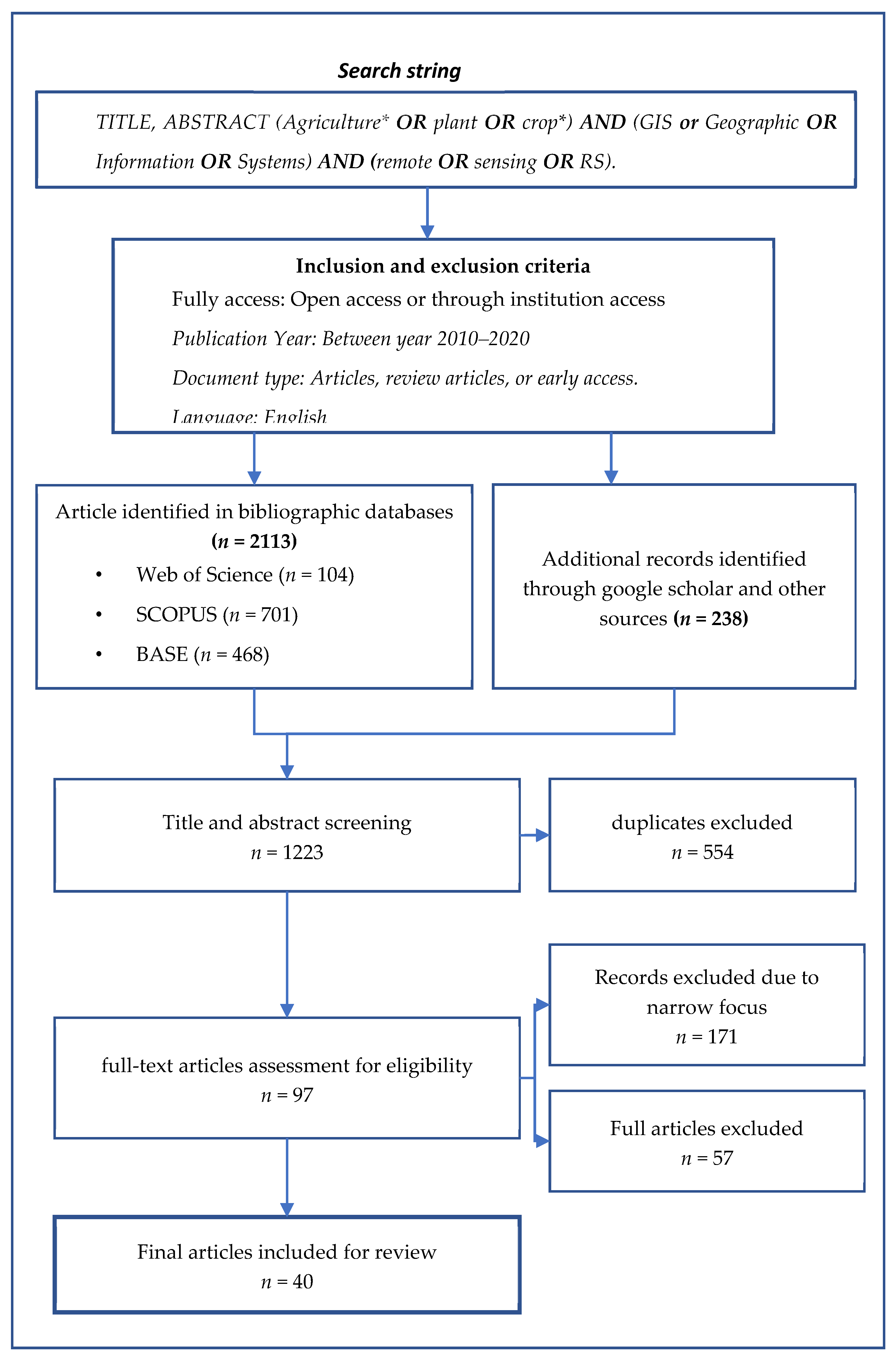
2. Review Methodology
2.1. Process of Screening
2.2. Data Extraction and Analysis
3. Results
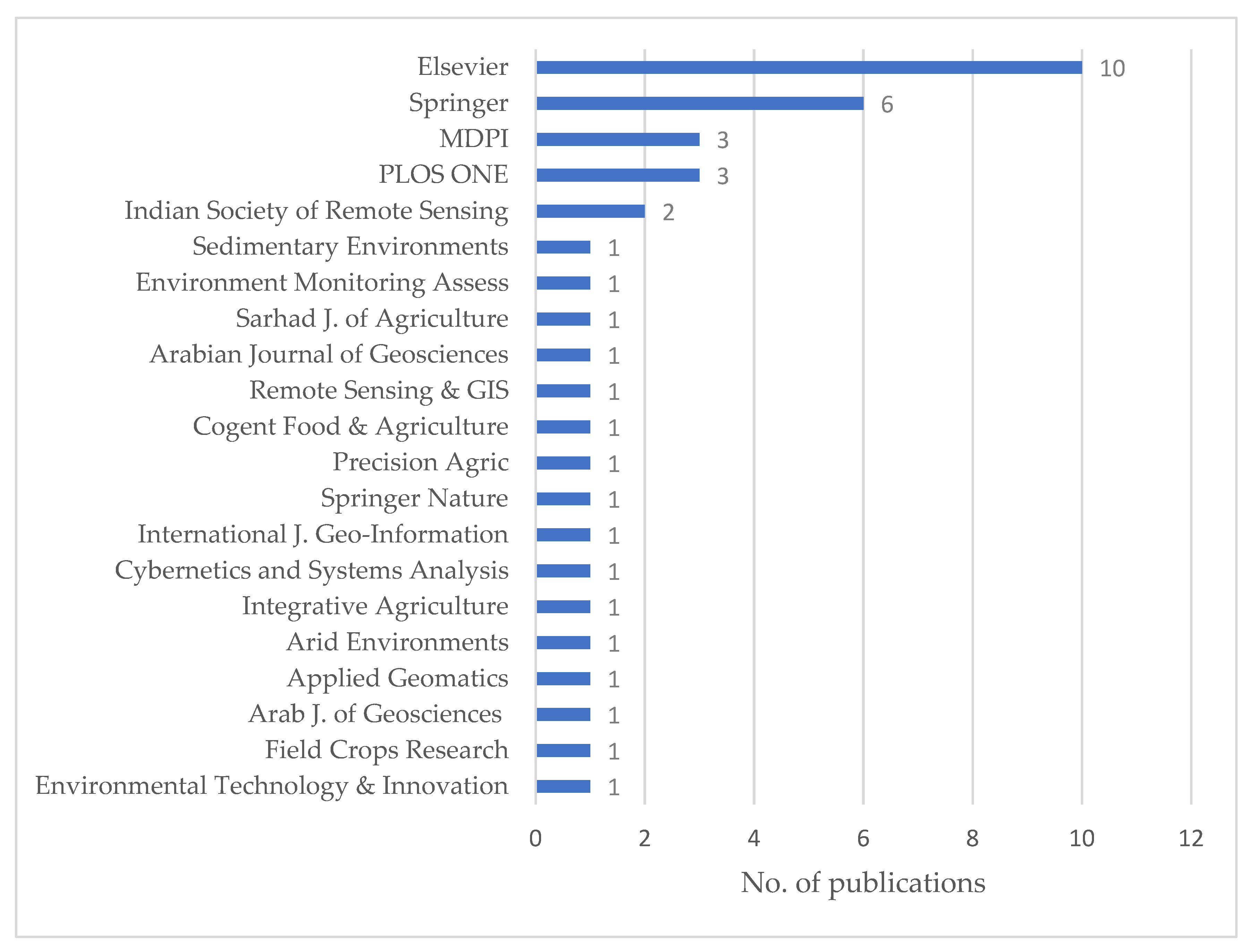
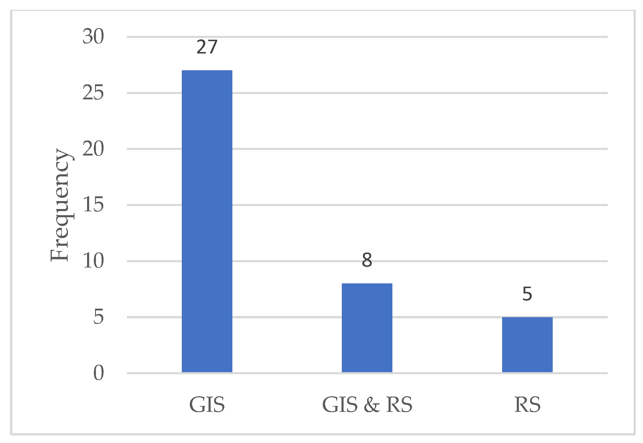
3.1. Characterization of the Selected Papers
3.2. GIS Application in Agriculture and the Implication to Policy
3.2.1. Crop Yield Estimation/Forecasting
3.2.2. Soil Quality/Fertility Assessment
3.2.3. Crop Mapping and Monitoring Decision Support Systems
3.2.4. Agricultural Drought Assessment
3.2.5. Pest and Crop Disease Detection and Management
3.2.6. Precision Agriculture
3.2.7. Weed Management and Fertilizer Decision Support System
4. Obstacles to Applying GIS in Agriculture Policy and Practice
5. Conclusions
6. Limitations of the Study
Author Contributions
Funding
Conflicts of Interest
Appendix A


| CORE database search string: (date of search: 25.10.2021): 68 articles found |
| title:((Agriculture, AND GIS, AND Remote AND sensing,)) AND year: [2010 TO 2021] |
| Web of Science query (date of search: 26.10.2021): 104 articles found |
| https://www.webofscience.com/wos/woscc/summary/79c860ee-207f-46ca-8db2-f70df81462ed-0eff1eca/relevance/1 Search refined by: Publication Years: Between 2021 and 2010: Document Types: Articles or Review Articles or Early Access: Languages: English: Open Access: All Open Access or Gold or Gold-Hybrid or Green Published or Free to Read: Document Types: Articles Web of Science Categories: Remote Sensing or Geosciences Multidisciplinary or Green Sustainable Science Technology or Multidisciplinary Sciences or Agronomy or Ecology or Geography Physical or Plant Sciences or Agriculture Multidisciplinary or Computer Science Information Systems or Soil Science or Agricultural Engineering or Agricultural Economics Policy or Food Science Technology or Horticulture or Nutrition Dietetics or Environmental Sciences or Environmental Studies. |
| SCOPUS search query (date of search: 26.10.2021) |
| TITLE-ABS-KEY (gis, AND agriculture, AND remote AND sensing, OR rs OR geographic OR information OR systems) AND (LIMIT-TO (PUBYEAR, 2022) OR LIMIT-TO (PUBYEAR, 2021) OR LIMIT-TO (PUBYEAR, 2020) OR LIMIT-TO (PUBYEAR, 2019) OR LIMIT-TO (PUBYEAR, 2018) OR LIMIT-TO (PUBYEAR, 2017) OR LIMIT-TO (PUBYEAR, 2016) OR LIMIT-TO (PUBYEAR, 2015) OR LIMIT-TO (PUBYEAR, 2014) OR LIMIT-TO (PUBYEAR, 2013) OR LIMIT-TO (PUBYEAR, 2012) OR LIMIT-TO (PUBYEAR, 2011) OR LIMIT-TO (PUBYEAR, 2010)) AND (LIMIT-TO (DOCTYPE, “ar”)) AND (LIMIT-TO (LANGUAGE, “English”)) AND (LIMIT-TO (EXACTKEYWORD, “Remote Sensing”) OR LIMIT-TO (EXACTKEYWORD, “GIS”) OR LIMIT-TO (EXACTKEYWORD, “Agriculture”) OR LIMIT-TO (EXACTKEYWORD, “Geographic Information Systems”) OR LIMIT-TO (EXACTKEYWORD, “Agricultural Land”) OR LIMIT-TO (EXACTKEYWORD, “Geographic Information System”) OR LIMIT-TO (EXACTKEYWORD, “Remote Sensing And GIS”) OR LIMIT-TO (EXACTKEYWORD, “Remote Sensing Technology”) OR LIMIT-TO (EXACTKEYWORD, “Spatial Analysis”) OR LIMIT-TO (EXACTKEYWORD, “Agricultural Robots”) OR LIMIT-TO (EXACTKEYWORD, “Soils”) OR LIMIT-TO (EXACTKEYWORD, “Sustainability”) OR LIMIT-TO (EXACTKEYWORD, “Decision Making”) OR LIMIT-TO (EXACTKEYWORD, “Soil”) OR LIMIT-TO (EXACTKEYWORD, “Precision Agriculture”) OR LIMIT-TO (EXACTKEYWORD, “Prediction”) OR LIMIT-TO (EXACTKEYWORD, “Crop Production”) OR LIMIT-TO (EXACTKEYWORD, “Agricultural Production”) OR LIMIT-TO (EXACTKEYWORD, “Crop Yield”) OR LIMIT-TO (EXACTKEYWORD, “Agricultural Development”) OR LIMIT-TO (EXACTKEYWORD, “Drought”) OR LIMIT-TO (EXACTKEYWORD, “Irrigation (agriculture)”) OR LIMIT-TO (EXACTKEYWORD, “Geographic Information System (GIS)”) OR LIMIT-TO (EXACTKEYWORD, “Alternative Agriculture”) OR LIMIT-TO (EXACTKEYWORD, “Food Security”)) |
References
- Valin, H.; Sands, R.; Van Der Mensbrugghe, D.; Nelson, G.C.; Ahammad, H.; Blanc, E.; Bodirsky, B.L.; Fujimori, S.; Hasegawa, T.; Havlik, P.; et al. The future of food demand: Understanding differences in global economic models. Agric. Econ. 2014, 45, 51–67. [Google Scholar] [CrossRef]
- FAO; IFAD; UNICEF; WFP; WHO. The State of Food Security and Nutrition in the World 2019: Safeguarding against Economic Slowdowns and Downturns; FAO: Rome, Italy, 2019. [Google Scholar]
- Elahi, E.; Zhang, Z.; Khalid, Z.; Xu, H. Application of an artificial neural network to optimise energy inputs: An energy- and cost-saving strategy for commercial poultry farms. Energy 2022, 244, 123169. [Google Scholar] [CrossRef]
- Godfray, H.C.J.; Beddington, J.R.; Crute, I.R.; Haddad, L.; Lawrence, D.; Muir, J.F.; Pretty, J.; Robinson, S.; Thomas, S.M.; Toulmin, C. Food Security: The Challenge of Feeding 9 Billion People. Science 2010, 327, 812–818. [Google Scholar] [CrossRef]
- Alexandratos, N.; Bruinsma, J. World agriculture towards 2030/2050. Land Use Policy 2012, 20, 375. [Google Scholar]
- Misselhorn, A.; Aggarwal, P.; Ericksen, P.; Gregory, P.; Horn-Phathanothai, L.; Ingram, J.; Wiebe, K. A vision for attaining food security. Curr. Opin. Environ. Sustain. 2012, 4, 7–17. [Google Scholar] [CrossRef]
- Elahi, E.; Khalid, Z.; Tauni, M.Z.; Zhang, H.; Lirong, X. Extreme weather events risk to crop-production and the adaptation of innovative management strategies to mitigate the risk: A retrospective survey of rural Punjab, Pakistan. Technovation 2021, 102255. [Google Scholar] [CrossRef]
- Lanya, I.; Subadiyasa, N.; Sardiana, K.; Ratna Adi, G.P. Remote sensing and GIS applications for planning of sustainable food agriculture land and agricultural commodity development in Denpasar City. In IOP Conference Series: Earth and Environmental Science; IOP Publishing: Bristol, UK, 2019. [Google Scholar]
- Merchant, J.; Narumalani, S. Integrating Remote Sensing and Geographic Information Systems; SAGE Publications: London, UK, 2009. [Google Scholar]
- Goodchild, M.F. Spatial thinking and the GIS user interface. Procedia-Soc. Behav. Sci. 2011, 21, 3–9. [Google Scholar] [CrossRef]
- García-Berná, J.A.; Ouhbi, S.; Benmouna, B.; García-Mateos, G.; Fernández-Alemán, J.L.; Molina-Martínez, J.M. Systematic Mapping Study on Remote Sensing in Agriculture. Appl. Sci. 2020, 10, 3456. [Google Scholar] [CrossRef]
- Weiss, M.; Jacob, F.; Duveiller, G. Remote sensing for agricultural applications: A meta-review. Remote Sens. Environ. 2020, 236, 111402. [Google Scholar] [CrossRef]
- Mathenge, M.; Sonneveld, B.G.J.; Broerse, J.E. A Spatially Explicit Approach for Targeting Resource-Poor Smallholders to Improve Their Participation in Agribusiness: A Case of Nyando and Vihiga County in Western Kenya. ISPRS Int. J. Geo-Inf. 2020, 9, 612. [Google Scholar] [CrossRef]
- Li, R.; Wei, C.; Afroz, M.D.; Lyu, J.; Chen, G. A GIS-based framework for local agricultural decision-making and regional crop yield simulation. Agric. Syst. 2021, 193, 103213. [Google Scholar] [CrossRef]
- Brion, J.D.; Balahadia, F.F. Application of remote sensing and GIS for climate change and agriculture in Philippines. In Proceedings of the 2017 IEEE 15th Student Conference on Research and Development: Inspiring Technology for Humanity (SCOReD 2017), Putrajaya, Malaysia, 13–14 December 2017; pp. 229–233. [Google Scholar]
- Wang, Y.; Chen, Y.; Peng, S. A GIS Framework for Changing Cropping Pattern Under Different Climate Conditions and Irrigation Availability Scenarios. Water Resour. Manag. 2011, 25, 3073–3090. [Google Scholar] [CrossRef]
- Markoski, M.; Arsov, S.; Mitkova, T.; Janeska-Stamenkovska, I. The benefit GIS technologies and precision agriculture principles in soil nutrient management for agricultural crop production. Bulg. J. Agric. Sci. 2015, 21, 554–559. [Google Scholar]
- Clay, D.E.; Shanahan, J.F. GIS Applications in Agriculture: Volume Two: Nutrient Management for Energy Efficiency; CRC Press: Boca Raton, FL, USA, 2011; pp. 1–445. [Google Scholar]
- Thakur, J.K.; Singh, S.K.; Ekanthalu, V.S. Integrating remote sensing, geographic information systems and global positioning system techniques with hydrological modeling. Appl. Water Sci. 2017, 7, 1595–1608. [Google Scholar] [CrossRef]
- Nie, P.; Di, W.; Yang, Y.; He, Y. Hybrid combination of GIS,GPS,WSN and GPRS technology in modern digital agriculture application. Adv. Mater. Res. 2010, 108, 1158–1163. [Google Scholar] [CrossRef]
- Dunaieva, I.; Mirschel, W.; Popovych, V.; Pashtetsky, V.; Golovastova, E.; Vecherkov, V.; Melnichuk, A.; Terleev, V.; Nikonorov, A.; Ginevsky, R. GIS Services for Agriculture Monitoring and Forecasting: Development Concept BT. In Proceedings of the International Scientific Conference Energy Management of Municipal Facilities and Sustainable Energy Technologies EMMFT, Samara, Russia, 10–13 December 2018; Murgul, V., Pasetti, M., Eds.; Springer: Cham, Switzerland, 2019; pp. 236–246. [Google Scholar]
- Al-Ismaili, A.M. GIS and remote sensing techniques in Controlled Environment Agriculture: A review. J. Agric. Mar. Sci. JAMS. 2021, 26, 10–23. [Google Scholar] [CrossRef]
- Sharma, R.; Kamble, S.S.; Gunasekaran, A. Big GIS analytics framework for agriculture supply chains: A literature review identifying the current trends and future perspectives. Comput. Electron. Agric. 2018, 155, 103–120. [Google Scholar] [CrossRef]
- Memon, M.S.; Jun, Z.; Sun, C.; Jiang, C.; Xu, W.; Hu, Q.; Yang, H.; Ji, C. Assessment of Wheat Straw Cover and Yield Performance in a Rice-Wheat Cropping System by Using Landsat Satellite Data. Sustainability 2019, 11, 5369. [Google Scholar] [CrossRef]
- Wang, M.; Tao, F.; Shi, W. Corn Yield Forecasting in Northeast China Using Remotely Sensed Spectral Indices and Crop Phenology Metrics. J. Integr. Agric. 2014, 13, 1538–1545. [Google Scholar] [CrossRef]
- Mann, M.L.; Warner, J.M. Ethiopian wheat yield and yield gap estimation: A spatially explicit small area integrated data approach. Field Crop. Res. 2017, 201, 60–74. [Google Scholar] [CrossRef] [PubMed]
- Hassan, S.S.; Goheer, M.A. Modeling and Monitoring Wheat Crop Yield Using Geospatial Techniques: A Case Study of Potohar Region, Pakistan. J. Indian Soc. Remote Sens. 2021, 49, 1331–1342. [Google Scholar] [CrossRef]
- Muslim, M.; Romshoo, S.A.; Rather, A.Q. Paddy crop yield estimation in Kashmir Himalayan rice bowl using remote sensing and simulation model. Environ. Monit. Assess. 2015, 187, 316. [Google Scholar] [CrossRef] [PubMed]
- Al-Gaadi, K.A.; Hassaballa, A.; Tola, E.; Kayad, A.; Madugundu, R.; Alblewi, B.; Assiri, F. Prediction of Potato Crop Yield Using Precision Agriculture Techniques. PLoS One 2016, 11, e0162219. [Google Scholar] [CrossRef] [PubMed]
- Hochman, Z.; Gobbett, D.; Holzworth, D.; McClelland, T.; Van Rees, H.; Marinoni, O.; Garcia, J.N.; Horan, H. Reprint of “Quantifying yield gaps in rainfed cropping systems: A case study of wheat in Australia”. Field Crop. Res. 2013, 143, 65–75. [Google Scholar] [CrossRef]
- Houshyar, E.; Smith, P.; Mahmoodi-Eshkaftaki, M.; Azadi, H. Sustainability of wheat production in Southwest Iran: A fuzzy-GIS based evaluation by ANFIS. Cogent Food Agric. 2017, 3, 1327682. [Google Scholar] [CrossRef]
- Abdelfattah, M.A.; Kumar, A.T. A web-based GIS enabled soil information system for the United Arab Emirates and its applicability in agricultural land use planning. Arab. J. Geosci. 2015, 8, 1813–1827. [Google Scholar] [CrossRef]
- De Paul Obade, V.; Lal, R. Assessing land cover and soil quality by remote sensing and geographical information systems (GIS). Catena 2013, 104, 77–92. [Google Scholar] [CrossRef]
- Tunçay, T.; Kılıç, Ş.; Dedeoğlu, M.; Dengiz, O.; Başkan, O.; Bayramin, İ. Assessing soil fertility index based on remote sensing and gis techniques with field validation in a semiarid agricultural ecosystem. J. Arid Environ. 2021, 190, 104525. [Google Scholar] [CrossRef]
- Shokr, M.S.; Abdellatif, M.A.; El Baroudy, A.A.; Elnashar, A.; Ali, E.F.; Belal, A.A.; Attia, W.; Ahmed, M.; Aldosari, A.A.; Szantoi, Z.; et al. Development of a Spatial Model for Soil Quality Assessment under Arid and Semi-Arid Conditions. Sustainability 2021, 13, 2893. [Google Scholar] [CrossRef]
- AbdelRahman, M.; Hegab, R.; Yossif, T. Soil fertility assessment for optimal agricultural use using remote sensing and GIS technologies. Appl. Geomatics 2021, 13, 605–618. [Google Scholar] [CrossRef]
- Mokarram, M.; Hojati, M. Using ordered weight averaging (OWA) aggregation for multi-criteria soil fertility evaluation by GIS (case study: Southeast Iran). Comput. Electron. Agric. 2017, 132, 1–13. [Google Scholar] [CrossRef]
- Abdellatif, M.A.; El Baroudy, A.A.; Arshad, M.; Mahmoud, E.K.; Saleh, A.M.; Moghanm, F.S.; Shaltout, K.H.; Eid, E.M.; Shokr, M.S. A GIS-Based Approach for the Quantitative Assessment of Soil Quality and Sustainable Agriculture. Sustainability 2021, 13, 13438. [Google Scholar] [CrossRef]
- Santosh, K.; Suresh, D. A Web GIS Based Decision Support System for Agriculture Crop Monitoring System-A Case Study from Part of Medak District. J. Remote Sens. GIS 2016, 5, 177–197. [Google Scholar]
- Singha, C.; Swain, K.C.; Swain, S.K. Best Crop Rotation Selection with GIS-AHP Technique Using Soil Nutrient Variability. Agriculture 2020, 10, 213. [Google Scholar] [CrossRef]
- Shelestov, A.Y.; Kravchenko, A.N.; Skakun, S.V.; Voloshin, S.V.; Kussul, N.N. Geospatial information system for agricultural monitoring. Cybern. Syst. Anal. 2013, 49, 124–132. [Google Scholar] [CrossRef]
- Thorp, K.R.; Hunsaker, D.J.; French, A.N.; Bautista, E.; Bronson, K.F. Integrating geospatial data and cropping system simulation within a geographic information system to analyze spatial seed cotton yield, water use, and irrigation requirements. Precis. Agric. 2015, 16, 532–557. [Google Scholar] [CrossRef]
- Hoque, M.A.-A.; Pradhan, B.; Ahmed, N.; Sohel, M.S.I. Agricultural drought risk assessment of Northern New South Wales, Australia using geospatial techniques. Sci. Total Environ. 2021, 756, 143600. [Google Scholar] [CrossRef] [PubMed]
- Sehgal, V.K.; Dhakar, R. Geospatial approach for assessment of biophysical vulnerability to agricultural drought and its intra-seasonal variations. Environ. Monit. Assess. 2016, 188, 197. [Google Scholar] [CrossRef] [PubMed]
- Aziz, A.; Hossain, A.B.M.Z.; Moniruzzaman, M.; Ahmed, R.; Zahan, T.; Azim, S.; Qayum, A.; Al Mamun, A.; Kader, A.; Rahman, N.M.F. Mapping of Agricultural Drought in Bangladesh using Geographic Information System (GIS). Earth Syst. Environ. 2021. [Google Scholar] [CrossRef]
- Sarkar, H.; Soni, S.; Ahmad, I.; Verma, M.K. Assessment of Agricultural Drought in Upper Seonath Sub-Basin of Chhattisgarh (India) Using Remote Sensing and GIS-Based Indices. J. Indian Soc. Remote Sens. 2020, 48, 921–933. [Google Scholar] [CrossRef]
- Kamruzzaman, M.; Kabir, E.; Rahman, A.T.M.; Jahan, C.; Mazumder, Q.; Rahman, M.S. Modeling of agricultural drought risk pattern using Markov chain and GIS in the western part of Bangladesh. Environ. Dev. Sustain. 2018, 20, 569–588. [Google Scholar] [CrossRef]
- Alshaikh, A.Y. Space applications for drought assessment in Wadi-Dama (West Tabouk), KSA. Egypt. J. Remote Sens. Space Sci. 2015, 18, S43–S53. [Google Scholar] [CrossRef]
- Lou, W.; Ji, Z.; Sun, K.; Zhou, J. Application of remote sensing and GIS for assessing economic loss caused by frost damage to tea plantations. Precis. Agric. 2013, 14, 606–620. [Google Scholar] [CrossRef]
- Santoso, H.; Gunawan, T.; Jatmiko, R.H.; Darmosarkoro, W.; Minasny, B. Mapping and identifying basal stem rot disease in oil palms in North Sumatra with QuickBird imagery. Precis. Agric. 2011, 12, 233–248. [Google Scholar] [CrossRef]
- Roberts, D.P.; Short, N.M.; Sill, J.; Lakshman, D.K.; Hu, X.; Buser, M. Precision agriculture and geospatial techniques for sustainable disease control. Indian Phytopathol. 2021, 74, 287–305. [Google Scholar] [CrossRef]
- Yang, C. Remote Sensing and Precision Agriculture Technologies for Crop Disease Detection and Management with a Practical Application Example. Engineering 2020, 6, 528–532. [Google Scholar] [CrossRef]
- Nahry, A.H.E.; Ali, R.R.; Baroudy, A.A.E. An approach for precision farming under pivot irrigation system using remote sensing and GIS techniques. Agric. Water Manag. 2011, 98, 517–531. [Google Scholar] [CrossRef]
- Wachowiak, M.P.; Walters, D.F.; Kovacs, J.M.; Wachowiak-Smolíková, R.; James, A.L. Visual analytics and remote sensing imagery to support community-based research for precision agriculture in emerging areas. Comput. Electron. Agric. 2017, 143, 149–164. [Google Scholar] [CrossRef]
- Fareed, N.; Rehman, K. Integration of remote sensing and GIS to extract plantation rows from a drone-based image point cloud digital surface model. ISPRS Int. J. Geo-Inf. 2020, 9, 151. [Google Scholar] [CrossRef]
- Xie, Y.W.; Yang, J.Y.; Du, S.L.; Zhao, J.; Li, Y.; Huffman, E.C. A GIS-based fertilizer decision support system for farmers in Northeast China: A case study at Tong-le village. Nutr. Cycl. Agroecosystems 2012, 93, 323–336. [Google Scholar] [CrossRef]
- Golmohammadi, M.J.; Chamanabad, H.R.M.; Yaghoubi, B.; Oveisi, M. GIS Applications in Surveying and Mapping of Rice Weeds in Guilan Province, Iran. Sarhad J. Agric. 2020, 36, 1103–1111. [Google Scholar] [CrossRef]
- Toscano, P.; Castrignanò, A.; Di Gennaro, S.F.; Vonella, A.V.; Ventrella, D.; Matese, A. A Precision Agriculture Approach for Durum Wheat Yield Assessment Using Remote Sensing Data and Yield Mapping. Agronomy 2019, 9, 437. [Google Scholar] [CrossRef]
- García, L.; Parra, L.; Jimenez, J.M.; Lloret, J.; Mauri, P.V.; Lorenz, P. DronAway: A Proposal on the Use of Remote Sensing Drones as Mobile Gateway for WSN in Precision Agriculture. Appl. Sci. 2020, 10, 6668. [Google Scholar] [CrossRef]
- Segarra, J.; Buchaillot, M.L.; Araus, J.L.; Kefauver, S.C. Remote Sensing for Precision Agriculture: Sentinel-2 Improved Features and Applications. Agronomy 2020, 10, 641. [Google Scholar] [CrossRef]
- Elahi, E.; Khalid, Z.; Zhang, Z. Understanding farmers’ intention and willingness to install renewable energy technology: A solution to reduce the environmental emissions of agriculture. Appl. Energy 2022, 309, 118459. [Google Scholar] [CrossRef]
- Elahi, E.; Zhang, H.; Lirong, X.; Khalid, Z.; Xu, H. Understanding cognitive and socio-psychological factors determining farmers’ intentions to use improved grassland: Implications of land use policy for sustainable pasture production. Land Use Policy 2021, 102, 105250. [Google Scholar] [CrossRef]
- Naik, G.; Basavaraj, K.P.; Hegde, V.R.; Paidi, V.; Subramanian, A. Using geospatial technology to strengthen data systems in developing countries: The case of agricultural statistics in India. Appl. Geogr. 2013, 43, 99–112. [Google Scholar] [CrossRef]


| Criteria | Category | No. of Articles | % |
|---|---|---|---|
| Field of GIS application | Crop yield estimation/forecasting | 12 | 30% |
| Soil fertility assessment | 9 | 22.5% | |
| Cropping pattern and monitoring | 4 | 10% | |
| Drought risk assessment | 3 | 10% | |
| Pest and crop disease detection | 3 | 7.5% | |
| Precision agriculture | 3 | 7.5% | |
| Fertilizer and weed management | 2 | 5% | |
| Publication year | 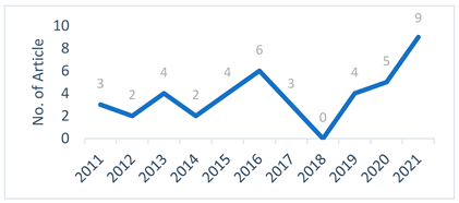 | ||
| Region of case study | East Asia and pacific | 14 | 35% |
| Europe and Central Asia | 3 | 7.5% | |
| South Asia | 11 | 27.5% | |
| North America | 4 | 10% | |
| The Middle East and North Africa | 7 | 17.5% | |
| Sub-Sahara Africa | 1 | 2.5% | |
| Research Topic/GIS Application Areas | Reference | No. of Publications | |
|---|---|---|---|
| 1. | Crop yield estimation/Forecasting | [24,25,26,27,28,29,30,31] | 12 |
| 2. | Soil fertility assessment | [32,33,34,35,36,37,38] | 7 |
| 3. | Cropping patterns and agricultural monitoring | [16,39,40,41,42] | 5 |
| 4. | Drought assessment | [43,44,45,46,47,48] | 6 |
| 5. | Pest and crop disease detection and management | [49,50,51,52] | 4 |
| 6. | Precision agriculture | [53,54,55] | 3 |
| 7. | Fertilizer and weed management | [21,56,57] | 3 |
Publisher’s Note: MDPI stays neutral with regard to jurisdictional claims in published maps and institutional affiliations. |
© 2022 by the authors. Licensee MDPI, Basel, Switzerland. This article is an open access article distributed under the terms and conditions of the Creative Commons Attribution (CC BY) license (https://creativecommons.org/licenses/by/4.0/).
Share and Cite
Mathenge, M.; Sonneveld, B.G.J.S.; Broerse, J.E.W. Application of GIS in Agriculture in Promoting Evidence-Informed Decision Making for Improving Agriculture Sustainability: A Systematic Review. Sustainability 2022, 14, 9974. https://doi.org/10.3390/su14169974
Mathenge M, Sonneveld BGJS, Broerse JEW. Application of GIS in Agriculture in Promoting Evidence-Informed Decision Making for Improving Agriculture Sustainability: A Systematic Review. Sustainability. 2022; 14(16):9974. https://doi.org/10.3390/su14169974
Chicago/Turabian StyleMathenge, Mwehe, Ben G. J. S. Sonneveld, and Jacqueline E. W. Broerse. 2022. "Application of GIS in Agriculture in Promoting Evidence-Informed Decision Making for Improving Agriculture Sustainability: A Systematic Review" Sustainability 14, no. 16: 9974. https://doi.org/10.3390/su14169974
APA StyleMathenge, M., Sonneveld, B. G. J. S., & Broerse, J. E. W. (2022). Application of GIS in Agriculture in Promoting Evidence-Informed Decision Making for Improving Agriculture Sustainability: A Systematic Review. Sustainability, 14(16), 9974. https://doi.org/10.3390/su14169974