
Surface Soil Moisture Inversion and Distribution Based on Spatio-Temporal Fusion of MODIS and Landsat

Abstract
:1. Introduction
2. Study Area and Data Collection
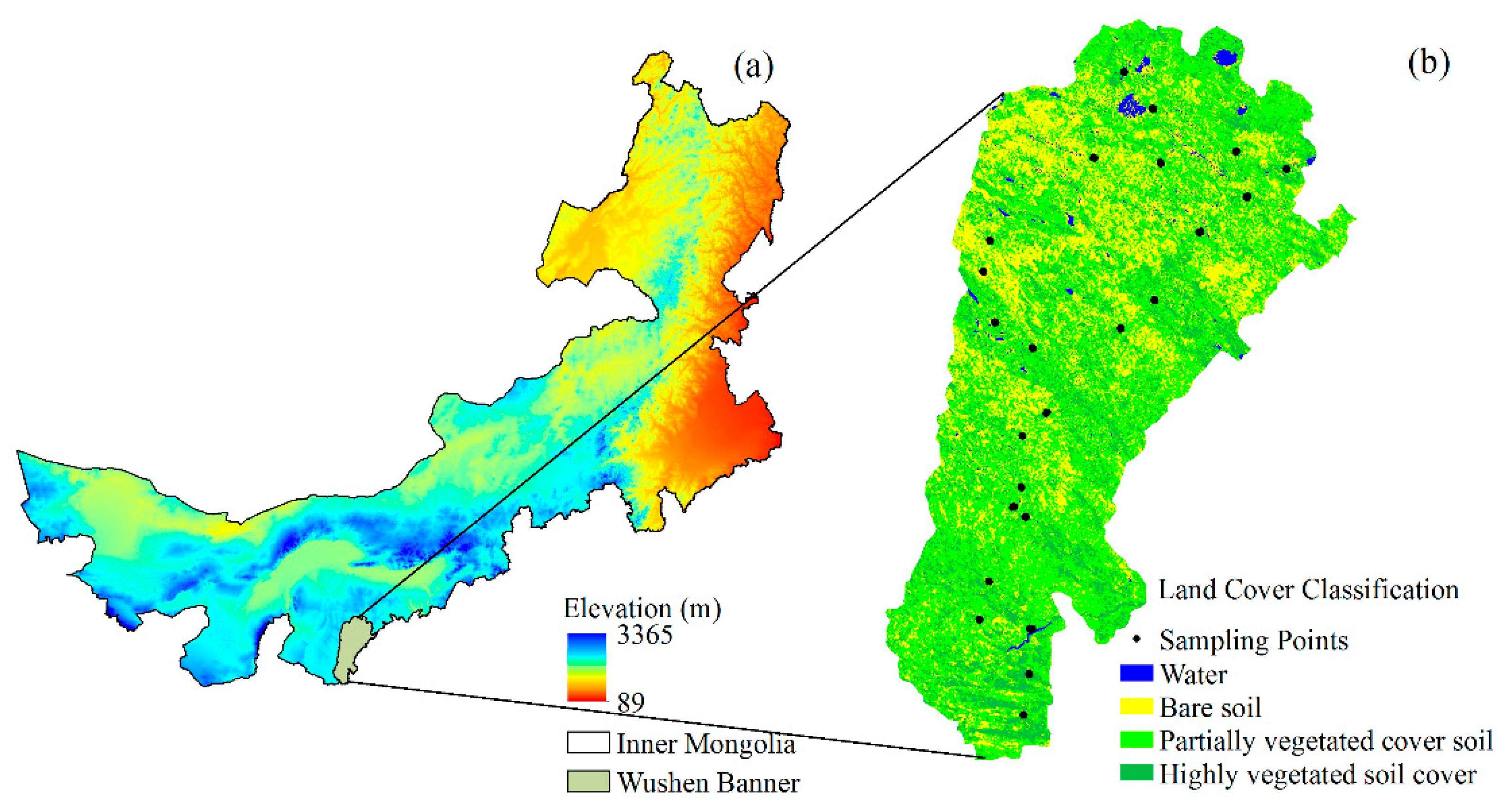
2.1. Study Area
2.2. Data
2.2.1. Remote Sensing Data
2.2.2. Measured Soil Moisture Data
2.3. Methods
2.3.1. ESTARFM Fusion Model
2.3.2. Visible Optical and Short-Wave Infrared Drought Index
2.3.3. Normalized Differential Infrared Index
2.3.4. Short-Wave Infrared Water Stress Index
2.3.5. Stepwise Regression Method
2.3.6. Accuracy Evaluation
3. Results
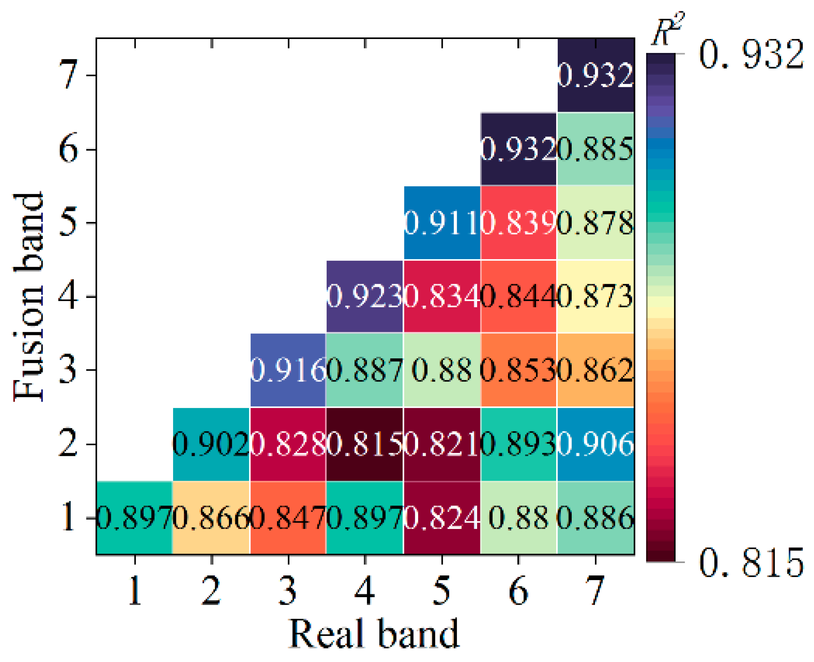
3.1. ESTARFM Spatio-Temporal Fusion Model Accuracy Evaluation
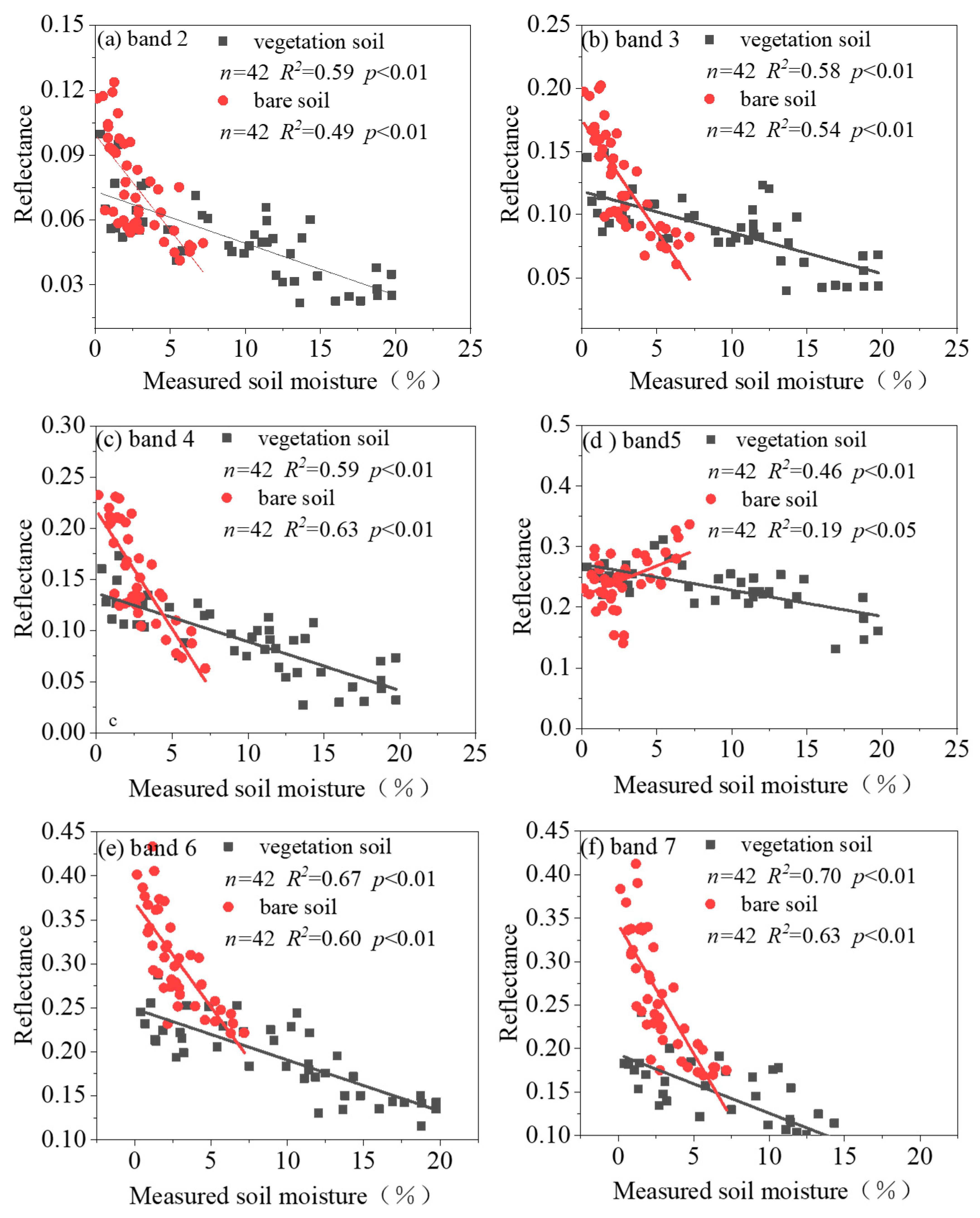
3.2. Vegetation and Bare Soil Reflectance Sensitivity Analysis on the Surface Soil Moisture
3.3. Correlation Analysis of the Spectral Index and the Surface Soil Moisture
3.4. Surface Soil Moisture Modeled by the Stepwise Linear Regression
3.5. Model Validation
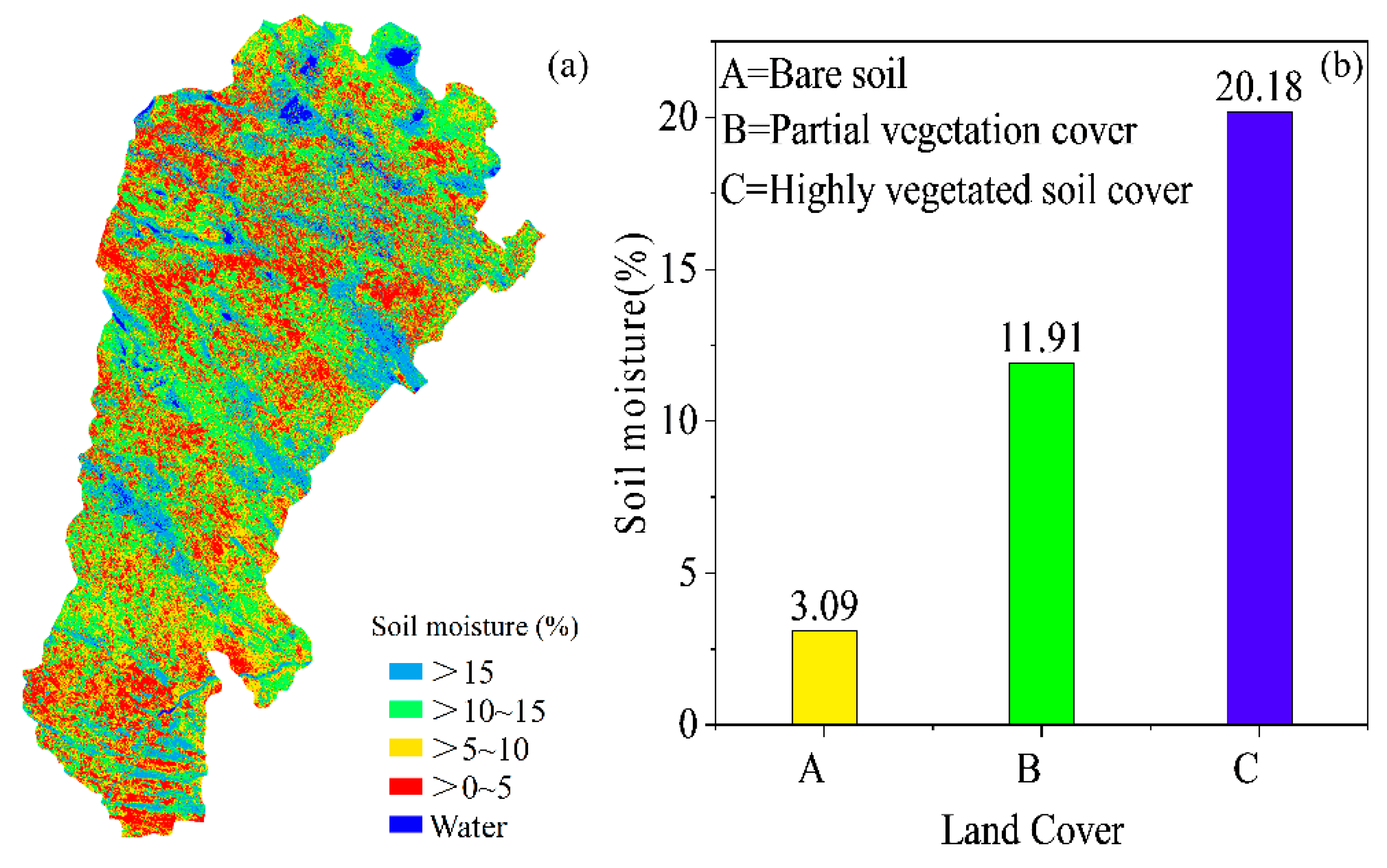
3.6. Soil Moisture Spatial Distribution Characteristics
4. Discussion
5. Conclusions
- (1)
- In this study, the VSDI, NDII, and SIWSI were found to be positively correlated with surface soil moisture, among which the VSDI had the highest correlation with surface soil moisture for bare soil (NDVI < 0.2), partially vegetated soil (0.2 < NDVI < 0.5), and highly vegetated soil (NDVI > 0.5), with R2 values of 0.69, 0.68, and 0.47, and RMSE values of 1.76%, 1.59%, and 1.36%, respectively;
- (2)
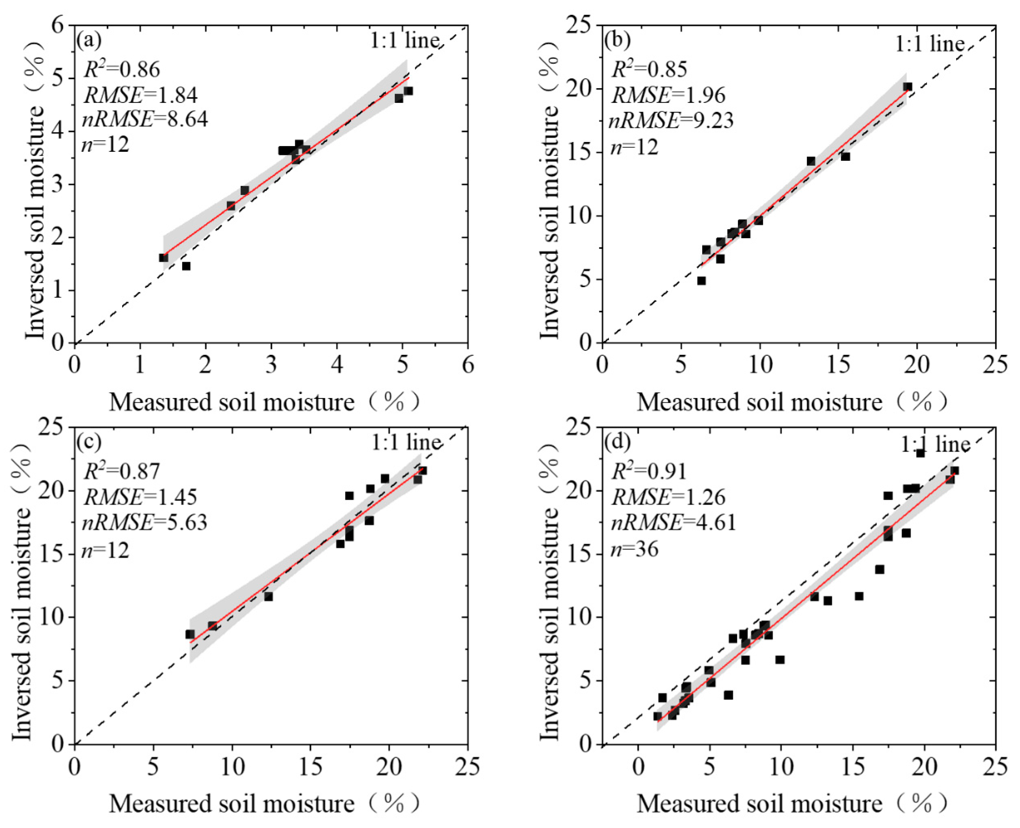
- Surface soil moisture models were evaluated using the validation set. In bare soil, the values of R2, RMSE, and nRMSE were 0.86, 1.84%, and 8.64%, respectively. In partially vegetated soils, the values of R2, RMSE, and nRMSE were 0.84, 1.96%, and 9.23%, respectively. In the highly vegetated cover soil, the values of R2, RMSE, and nRMSE were 0.87, 1.45%, and 5.63%, respectively. This indicates that the developed model can better reflect the actual level of surface soil moisture in different land cover types;
- (3)
- The soil water content in the study area averaged around 13.41% in August. Additionally, different vegetation cover types had large differences in water content, with the highest soil water content found in the highly vegetated cover (20.18%), the lowest soil water content found in the partially vegetated cover (11.91%), and an average soil water content of 3.09% found in the bare soil.
Author Contributions
Funding
Institutional Review Board Statement
Informed Consent Statement
Data Availability Statement
Conflicts of Interest
References
- Gidey, E.; Dikinya, O.; Sebego, R.; Segosebe, E.; Zenebe, A. Analysis of the long-term agricultural drought onset, cessation, duration, frequency, severity and spatial extent using Vegetation Health Index (VHI) in Raya and its environs, Northern Ethiopia. Environ. Syst. Res. 2018, 7, 13. [Google Scholar] [CrossRef] [Green Version]
- Choi, M.; Jacobs, J.M.; Anderson, M.C.; Bosch, D.D. Evaluation of drought indices via remotely sensed data with hydrological variables. J. Hydrol. 2013, 476, 265–273. [Google Scholar] [CrossRef]
- Dai, A. Drought under global warming: A review. Wiley Interdiscip. Rev. Clim. Chang. 2011, 2, 45–65. [Google Scholar] [CrossRef] [Green Version]
- Wang, H.; Liu, G.; Li, Z.; Ye, X.; Fu, B.; Lv, Y. Impacts of Drought and Human Activity on Vegetation Growth in the Grain for Green Program Region, China. Chin. Geogr. Sci. 2018, 28, 470–481. [Google Scholar] [CrossRef] [Green Version]
- Daly, E.; Porporato, A. A review of soil moisture dynamics: From rainfall infiltration to ecosystem response. Environ. Eng. Sci. 2005, 22, 9–24. [Google Scholar] [CrossRef]
- Nam, S.; Kang, S.; Kim, J. Maintaining a constant soil moisture level can enhance the growth and phenolic content of sweet basil better than fluctuating irrigation. Agric. Water Manag. 2020, 238, 106203. [Google Scholar] [CrossRef]
- Seneviratne, S.I.; Corti, T.; Davin, E.L.; Hirschi, M.; Jaeger, E.B.; Lehner, I.; Orlowsky, B.; Teuling, A.J. Investigating soil moisture–climate interactions in a changing climate: A review. Earth-Sci. Rev. 2010, 99, 125–161. [Google Scholar] [CrossRef]
- Behera, S.S.; Nikam, B.R.; Babel, M.S.; Garg, V.; Aggarwal, S.P. The Assimilation of Remote Sensing-Derived Soil Moisture Data into a Hydrological Model for the Mahanadi Basin, India. J. Indian Soc. Remote Sens. 2019, 47, 1357–1374. [Google Scholar] [CrossRef]
- Petropoulos, G.P.; Ireland, G.; Barrett, B. Surface soil moisture retrievals from remote sensing: Current status, products & future trends. Phys. Chem. Earth Parts A/B/C 2015, 83–84, 36–56. [Google Scholar]
- Jin, S.; Sader, S.A. Comparison of time series tasseled cap wetness and the normalized difference moisture index in detecting forest disturbances. Remote Sens. Environ. 2005, 94, 364–372. [Google Scholar] [CrossRef]
- Bidgoli, R.D.; Koohbanani, H.; Keshavarzi, A.; Kumar, V. Measurement and zonation of soil surface moisture in arid and semi-arid regions using Landsat 8 images. Arab. J. Geosci. 2020, 13, 826. [Google Scholar] [CrossRef]
- Rahimzadeh-Bajgiran, P.; Berg, A.A.; Champagne, C.; Omasa, K. Estimation of soil moisture using optical/thermal infrared remote sensing in the Canadian Prairies. ISPRS J. Photogramm. Remote Sens. 2013, 83, 94–103. [Google Scholar] [CrossRef]
- Qin, J.; Yang, K.; Lu, N.; Chen, Y.; Zhao, L.; Han, M. Spatial upscaling of in-situ soil moisture measurements based on MODIS-derived apparent thermal inertia. Remote Sens. Environ. 2013, 138, 1–9. [Google Scholar] [CrossRef]
- Ebtehaj, A.; Bras, R.L. A physically constrained inversion for high-resolution passive microwave retrieval of soil moisture and vegetation water content in L-band. Remote Sens. Environ. 2019, 233, 111346. [Google Scholar] [CrossRef]
- Kolassa, J.; Reichle, R.H.; Draper, C.S. Merging active and passive microwave observations in soil moisture data assimilation. Remote Sens. Environ. 2017, 191, 117–130. [Google Scholar] [CrossRef]
- Veysi, S.; Naseri, A.A.; Hamzeh, S. Relationship Between Field Measurement of Soil Moisture in the Effective Depth of Sugarcane Root Zone and Extracted Indices from Spectral Reflectance of Optical/Thermal Bands of Multispectral Satellite Images. J. Indian Soc. Remote Sens. 2020, 48, 1035–1044. [Google Scholar] [CrossRef]
- Bowers, S.A.; Hanks, R.J. Reflection of Radiant Energy from Soils. Soil Sci. 1965, 100, 130–138. [Google Scholar] [CrossRef] [Green Version]
- Rahimzadeh-Bajgiran, P.; Omasa, K.; Shimizu, Y. Comparative evaluation of the Vegetation Dryness Index (VDI), the Temperature Vegetation Dryness Index (TVDI) and the improved TVDI (iTVDI) for water stress detection in semi-arid regions of Iran. ISPRS J. Photogramm. Remote Sens. 2012, 68, 1–12. [Google Scholar] [CrossRef]
- Das, S. Characterization of Surface Geological Material in Northwest India and Adjoining Areas of Pakistan Using Normalized Difference Water Index, Land Surface Temperature and Silica Index. J. Indian Soc. Remote Sens. 2018, 46, 1645–1656. [Google Scholar] [CrossRef]
- Tavazohi, E.; Ahmadi, M. Assessment of drought in the Zayandehroud basin during 2000-2015 using NDDI and SPI indices. Fresenius Environ. Bull. 2018, 27, 2332–2340. [Google Scholar]
- Otkin, J.A.; Anderson, M.C.; Hain, C.; Svoboda, M.; Johnson, D.; Mueller, R.; Tadesse, T.; Wardlow, B.; Brown, J. Assessing the evolution of soil moisture and vegetation conditions during the 2012 United States flash drought. Agric. For. Meteorol. 2016, 218–219, 230–242. [Google Scholar] [CrossRef] [Green Version]
- Zhan, Z.; Qin, Q.; Ghulan, A.; Wang, D. NIR-red spectra space based new method for soil moisture monitoring. Sci. China Ser. D Earth Sci. 2007, 50, 283–289. [Google Scholar] [CrossRef]
- Ghulam, A.; Qin, Q.; Zhan, Z. Designing of the perpendicular drought index. Environ. Geol. 2007, 52, 1045–1052. [Google Scholar] [CrossRef]
- Liu, Y.; Wu, L.X.; Ma, B.D. Remote sensing monitoring of soil Moisture on the basis of TM/ETM + spectral space. Zhongguo Kuangye Daxue Xuebao/J. China Univ. Min. Technol. 2013, 42, 296–301. [Google Scholar]
- Zhang, H.; Chen, H.; Sun, R.; Yu, W.; Zou, C.; Shen, S. The Application of Unified Surface Water Capacity Method in Drought Remote Sensing Monitoring. In Remote Sensing for Agriculture, Ecosystems, and Hydrology XI; SPIE: Bellingham, WA, USA, 2009; pp. 324–330. [Google Scholar]
- Fensholt, R.; Sandholt, I. Derivation of a Shortwave Infrared Water Stress Index from MODIS Near- and Shortwave Infrared Data in a Semiarid Environment. Remote Sens. Environ. 2003, 87, 111–121. [Google Scholar] [CrossRef]
- Wang, L.; Qu, J. NMDI: A normalized multi-band drought index for monitoring soil and vegetation moisture with satellite remote sensing. Geophys. Res. Lett.-Geophy.s Res. Lett. 2007, 34. [Google Scholar] [CrossRef]
- Zhang, J.-H.; Zhou, Z.; Yao, F.; Yang, L.; Hao, C. Validating the Modified Perpendicular Drought Index in the North China Region Using In Situ Soil Moisture Measurement. IEEE Geosci. Remote Sens. Lett. 2015, 12, 542–546. [Google Scholar] [CrossRef]
- Zhang, N.; Hong, Y.; Qin, Q.; Liu, L. VSDI: A visible and shortwave infrared drought index for monitoring soil and vegetation moisture based on optical remote sensing. Int. J. Remote Sens. 2013, 34, 4585–4609. [Google Scholar] [CrossRef]
- Zhu, X.; Chen, J.; Gao, F.; Chen, X.; Masek, J.G. An enhanced spatial and temporal adaptive reflectance fusion model for complex heterogeneous regions. Remote Sens. Environ. 2010, 114, 2610–2623. [Google Scholar] [CrossRef]
- Sisheber, B.; Marshall, M.; Mengistu, D.; Nelson, A. Tracking crop phenology in a highly dynamic landscape with knowledge-based Landsat–MODIS data fusion. Int. J. Appl. Earth Obs. Geoinf. 2022, 106, 102670. [Google Scholar] [CrossRef]
- Ghosh, R.; Gupta, P.K.; Tolpekin, V.; Srivastav, S.K. An enhanced spatiotemporal fusion method—Implications for coal fire monitoring using satellite imagery. Int. J. Appl. Earth Obs. Geoinf. 2020, 88, 102056. [Google Scholar] [CrossRef]
- Zhou, X.; Wang, P.; Tansey, K.; Zhang, S.; Li, H.; Wang, L. Developing a fused vegetation temperature condition index for drought monitoring at field scales using Sentinel-2 and MODIS imagery. Comput. Electron. Agric. 2020, 168, 105144. [Google Scholar] [CrossRef]
- Benabdelouahab, T.; Balaghi, R.; Hadria, R.; Lionboui, H.; Minet, J.; Tychon, B. Monitoring surface water content using visible and short-wave infrared SPOT-5 data of wheat plots in irrigated semi-arid regions. Int. J. Remote Sens. 2015, 36, 4018–4036. [Google Scholar] [CrossRef]
- Zhang, N.; Hong, Y.; Qin, Q.; Zhu, L. Evaluation of the Visible and Shortwave Infrared Drought Index in China. Int. J. Disaster Risk Sci. 2013, 4, 68–76. [Google Scholar] [CrossRef] [Green Version]
- Zhou, H.; Zhou, G.; Song, X.; He, Q. Dynamic Characteristics of Canopy and Vegetation Water Content during an Entire Maize Growing Season in Relation to Spectral-Based Indices. Remote Sens. 2022, 14, 584. [Google Scholar] [CrossRef]
- Olsen, J.L.; Ceccato, P.; Proud, S.R.; Fensholt, R.; Grippa, M.; Mougin, E.; Ardö, J.; Sandholt, I. Relation between Seasonally Detrended Shortwave Infrared Reflectance Data and Land Surface Moisture in Semi-Arid Sahel. Remote Sens. 2013, 5, 2898–2927. [Google Scholar] [CrossRef] [Green Version]
- Dou, X.; Wang, X.; Liu, H.; Zhang, X.; Meng, L.; Pan, Y.; Yu, Z.; Cui, Y. Prediction of soil organic matter using multi-temporal satellite images in the Songnen Plain, China. Geoderma 2019, 356, 113896. [Google Scholar] [CrossRef]
- Bai, Y.; Zhou, Y. The main factors controlling spatial variability of soil organic carbon in a small karst watershed, Guizhou Province, China. Geoderma 2020, 357, 113938. [Google Scholar] [CrossRef]
- Yang, Z.; Zhao, J.; Liu, J.; Wen, Y.; Wang, Y. Soil Moisture Retrieval Using Microwave Remote Sensing Data and a Deep Belief Network in the Naqu Region of the Tibetan Plateau. Sustainability 2021, 13, 12635. [Google Scholar] [CrossRef]
- Khellouk, R.; Barakat, A.; Boudhar, A.; Hadria, R.; Lionboui, H.; El Jazouli, A.; Rais, J.; El Baghdadi, M.; Benabdelouahab, T. Spatiotemporal monitoring of surface soil moisture using optical remote sensing data: A case study in a semi-arid area. J. Spat. Sci. 2018, 65, 481–499. [Google Scholar] [CrossRef]
- Amani, M.; Parsian, S.; Mirmazloumi, S.M.; Aieneh, O. Two new soil moisture indices based on the NIR-red triangle space of Landsat-8 data. Int. J. Appl. Earth Obs. Geoinf. 2016, 50, 176–186. [Google Scholar] [CrossRef]
- Pinty, B.; Lavergne, T.; Widlowski, J.L.; Gobron, N.; Verstraete, M.M. On the need to observe vegetation canopies in the near-infrared to estimate visible light absorption. Remote Sens. Environ. 2009, 113, 10–23. [Google Scholar] [CrossRef]
- Li, C.; Zhu, X.-C.; Wei, Y.; Cao, S.; Guo, X.; Yu, X.; Chang, C. Estimating apple tree canopy chlorophyll content based on Sentinel-2A remote sensing imaging. Sci. Rep. 2018, 8, 3756. [Google Scholar] [CrossRef] [PubMed]
- Jia-hua, Z.; Li, L.; Feng-mei, Y. Progress in Retrieving Vegetation Water Content under Different Vegetation Coverage Condition Based on Remote Sensing Spectral Information. Spectrosc. Spectr. Anal. 2010, 30, 1638–1642. [Google Scholar]
- Wang, S.; Li, R.; Li, X. Inversion and distribution of soil moisture in belly of Maowusu sandy land based on comprehensive drought index. Trans. Chin. Soc. Agric. Eng. 2019, 35, 113–121. [Google Scholar]
- Shen, M.-S.; Zhang, J.-J.; Zhang, S.-H.; Zhang, H.-B.; Sun, R.-X.; Zhang, Y.-Z. Seasonal variations in the influence of vegetation cover on soil water on the loess hillslope. J. Mt. Sci. 2020, 17, 2148–2160. [Google Scholar] [CrossRef]
- Makhamreh, Z. Derivation of vegetation density and land-use type pattern in mountain regions of Jordan using multi-seasonal SPOT images. Environ. Earth Sci. 2018, 77, 384. [Google Scholar] [CrossRef]
- Shan, L.; Yu, X.; Sun, L.; He, B.; Wang, H.; Xie, T. Seasonal differences in climatic controls of vegetation growth in the Beijing–Tianjin Sand Source Region of China. J. Arid. Land 2018, 10, 850–863. [Google Scholar] [CrossRef] [Green Version]
- Jahangir, M.H.; Arast, M. Estimation of Surface Soil Moisture Based on Improved Multi-index Models and Surface Energy Balance System. Nat. Resour. Res. 2021, 30, 789–804. [Google Scholar] [CrossRef]


| NDVI < 0.2 | 0.2 < NDVI < 0.5 | NDVI > 0.5 | |||||||
|---|---|---|---|---|---|---|---|---|---|
| R2 | RMSE/% | nRMSE/% | R2 | RMSE/% | nRMSE/% | R2 | RMSE/% | nRMSE/% | |
| VSDI | 0.59 | 1.76 | 9.46 | 0.58 | 1.59 | 10.03 | 0.47 | 1.36 | 6.44 |
| NDII | 0.63 | 1.34 | 7.2 | 0.38 | 2.56 | 16.15 | 0.43 | 1.40 | 6.63 |
| SIWSI | 0.50 | 2.25 | 12.09 | 0.21 | 3.02 | 19.02 | 0.42 | 1.37 | 6.49 |
| Band m | Regression Model | R2 | RMSE/% | nRMSE/% | F Value | Sig. |
|---|---|---|---|---|---|---|
| 1 | Y = −0.002 × B7 + 9.09 | 0.62 | 3.87 | 16.35 | 43.64 | p < 0.01 |
| 2 | Y = 53.87 × B6 − 90.38 × B7 + 13.37 | 0.76 | 1.76 | 4.36 | 87.51 | p < 0.01 |
| 3 | Y = 186.34 × B4 + 18.95 × B6 − 226.84 × B7 + 21.03 | 0.83 | 1.65 | 3.57 | 123.65 | p < 0.01 |
| 4 | Y = 28.47 × B + 185.256 × B4 + 170.67 × B6 − 316.90 × B7 + 4.09 | 0.65 | 2.63 | 6.38 | 47.78 | p < 0.01 |
Publisher’s Note: MDPI stays neutral with regard to jurisdictional claims in published maps and institutional affiliations. |
© 2022 by the authors. Licensee MDPI, Basel, Switzerland. This article is an open access article distributed under the terms and conditions of the Creative Commons Attribution (CC BY) license (https://creativecommons.org/licenses/by/4.0/).
Share and Cite
Wang, S.; Wang, W.; Wu, Y.; Zhao, S. Surface Soil Moisture Inversion and Distribution Based on Spatio-Temporal Fusion of MODIS and Landsat. Sustainability 2022, 14, 9905. https://doi.org/10.3390/su14169905
Wang S, Wang W, Wu Y, Zhao S. Surface Soil Moisture Inversion and Distribution Based on Spatio-Temporal Fusion of MODIS and Landsat. Sustainability. 2022; 14(16):9905. https://doi.org/10.3390/su14169905
Chicago/Turabian StyleWang, Sinan, Wenjun Wang, Yingjie Wu, and Shuixia Zhao. 2022. "Surface Soil Moisture Inversion and Distribution Based on Spatio-Temporal Fusion of MODIS and Landsat" Sustainability 14, no. 16: 9905. https://doi.org/10.3390/su14169905
APA StyleWang, S., Wang, W., Wu, Y., & Zhao, S. (2022). Surface Soil Moisture Inversion and Distribution Based on Spatio-Temporal Fusion of MODIS and Landsat. Sustainability, 14(16), 9905. https://doi.org/10.3390/su14169905