Article

Ruins and Remains as a Background: Natural Catastrophes, Abandonment of Medieval Villages, and the Perspective of Civilization during the 20th Century in the Central Apennines (Abruzzi Region, Central Italy)

by
Fabrizio Galadini
Istituto Nazionale di Geofisica e Vulcanologia, 00143 Rome, Italy
Sustainability 2022, 14(15), 9517; https://doi.org/10.3390/su14159517
Submission received: 15 July 2022 / Revised: 29 July 2022 / Accepted: 31 July 2022 / Published: 3 August 2022

Abstract

:
The resettlement of villages strongly damaged by catastrophes during the 20th century played a key role in the modification of the Apennine landscape in Italy. Following their abandonment, the remains of the medieval settlements progressively deteriorated in their ruined condition, becoming ghost villages often made of sparse portions of buildings, traces of outer walls, and isolated vestiges of ancient monuments colonized by vegetation. Five cases of central Apennine abandoned villages in the Abruzzi region (Frattura, Sperone, Albe, Salle, and Gessopalena) were investigated, combining information on the local adverse geological conditions with the historical reconstruction of their abandonment and resettlement, based on archive documents from the 19th and 20th centuries. The history of these localities was conditioned by two strong earthquakes that struck the Abruzzi region in 1915 (magnitude 7.1) and 1933 (magnitude 5.9), and by slope instability. In all cases, abandonment and resettlement produced new villages against the background of ancient ruins and remains. In conclusion, the paper discusses the potential use of the material traces of local histories with educational aims. Geological evidence of natural hazards, remains of the abandoned settlements and resettled villages could be arranged in museums aimed at increasing the awareness of natural hazards and risks.

1. Introduction

The abandonment of built-up areas, often with centuries-old histories, is a worldwide issue. The historical reasons and the evolution of the abandonment are different in every case. Although the consequence may or may not be a new built-up area elsewhere, processes are always marked by unused buildings, remains, and ruins forming localities labelled as “ghost towns” (here intended as abandoned built-up areas; for example, see [1,2]). An aspect that these cases share is their uncertain future, as abandonment may be definitive and the previously inhabited places are progressively assimilated by the natural environment, or attempts to recover the ghost towns for different purposes (new residential plans, tourist proposals, open air museums, etc.; for example, see [3] for different options of regenerations in Italy) may be planned.
With its thousands of years of history, Italy offers a wide range of cases [4] that may be investigated, from a historical point of view, to define the causes that transformed a settlement into a ghost town. Most cases in central Italy can be detected along the Apennine chain. The physical landscape of this mountainous region is defined by NW-SE trending Mesozoic-Cenozoic carbonate ridges, reaching more than 2000 m a.s.l., deep valleys incised into the Miocene clayey-arenaceous flysch, and intermontane basins filled by Plio-Quaternary continental sediments. The centuries-old settlement history is related to the different options offered by this uneven topography. After the politically stable Roman Age, during which towns and villages were located in lowlands, resettlement occurred in the Medieval Age, between the 9th–10th century AD and the 13th century, when new built-up areas were located on isolated peaks, plateaus, or terraces at high altitudes, which were generally close to (or around) a castle [5,6,7,8,9,10]. The reasons for this shift in settlement have been traditionally identified in the defense against invasions and incursions, in the building of fortress networks to consolidate local political and military powers, and to control the lands exploited for farming [6]. This phase of resettlement generated the typical Apennine landscape, with scattered villages represented by small clusters of juxtaposed buildings made of masonry walls composed of carbonate (or arenaceous) stones and mortar. In most cases, the medieval building phase originated villages with a sort of symbiotic relationship with the geological substratum, representing man-made continuations of the natural reliefs towards the sky. This centuries-old landscape dominated by the medieval settlements was the object of romantic descriptions and pictorial representations between the 19th century and the beginning of the 20th; for example, see [11,12,13].
The changed political framework of the Modern Age rapidly made this model of settlement obsolete and aspects such as the distance from the main communication routes and (in some cases) from the cultivated lands, difficulties in supplying consumer goods, the backwardness of lifestyle, social isolation, and vulnerability with respect to banditry became priority issues in the Contemporary Age. For this reason, the deliberate migration of populations towards more convenient settlements in valleys and plains have occurred especially since the 19th century; for example, see [14].
Within this framework, a paramount role in the modification of the urban model was played by natural catastrophes during the 20th century. Damages to ancient buildings and real or presumed adverse geological conditions often offered the hints for resettlement and relocation of resident populations from the ancient rocky villages to the new and modernly structured built-up areas, characterized by more convenient locations for modern lifestyles.
As for the central Apennines of the Abruzzi region, the 1915 and 1933 earthquakes (magnitude Mw 7.1 and 5.9, respectively, in the CPTI15 catalog [15]) had a key role in triggering the resettlement (or completing it, if migration was already underway), through specific laws that, in some cases, imposed the abandonment of the ancient villages. The significant landscape modifications, in territories that had maintained their traditional aspect for centuries, occurred very rapidly, since resettlements usually needed no more than several decades.
Although historical events may be considerably different for each individual case, material evidence of the resettlements is comparable, generally represented by decaying remains of the abandoned ancient villages and by 20th century built-up areas characterized by the regularity of the layout and buildings, often in the style of social housing, which is far from the Apennine residential tradition.
Once the resettlement had been completed, only faint memories of the original villages survived, with mostly ruined buildings and walls progressively disappearing due to decay and colonization by vegetation. Presently, the main issues are the preservation of the abandoned remains and the perspectives for their exploitation. Clarity of ideas on the latter point does not always emerge from proposed plans, since hypotheses on rebuilding (e.g., to use the abandoned villages in the tourist perspective) sometimes coexist with completely different perspectives of cultural exploitation (e.g., by promoting the remains of the abandoned villages in archaeological areas).
On these grounds, after sections dedicated to the geological-seismological framework of the region and to the description of the sources of data necessary for this study, the history of five medieval villages of the Abruzzi region (Frattura, Sperone, Albe, Salle, and Gessopalena) are presented and discussed here, including the 20th century episodes of abandonment and resettlement. The adverse geological conditions, actual or simply presumed at the time of abandonment, are presented for each case, together with the earthquake damages suffered by the villages in 1915 and 1933. The investigation into natural processes, which affected these ancient built-up areas, may be included in the wide field of urban geology (e.g., see [16] for a worldwide review; see [17,18] for urban geology concerning Italian ancient cities, Rome and Naples, respectively, that were exposed to seismic, landslide, and sinkhole hazards). Their knowledge is also necessary in the perspective of a new utilization of the abandoned sites, regardless of what can be planned for their future. The framework will be completed by the definition of the steps of the resettlements and the contemporary abandonment of the original built-up areas. The following localities were chosen because of their peculiar history and for the different geological or geographic framework: (i) The medieval village of Frattura, almost destroyed by the 1915 earthquake, was believed to be founded on a landslide accumulation, but current knowledge defines a much more complicated geological framework than that presumed at the beginning of the 20th century. (ii) Sperone, strongly damaged by the 1915 earthquake, was rebuilt elsewhere on the basis of geological conditions different from the actual ones; moreover, it presents the peculiarity of two relocations that occurred in a time interval of a few decades following the earthquake. (iii) Medieval Albe, completely destroyed by the 1915 earthquake, experienced resettlement as decided by the survivors, while geological knowledge at that time erroneously considered the carbonate hill of the original settlement as a place suitable for reconstruction. (iv) Salle, moderately damaged by the 1915 and 1933 earthquakes, was originally built on a terrace made of debris and landslide accumulation, at the margin of a stream whose erosional action caused repeated landslide episodes, implying building collapse since the 19th century. Finally, (v) ancient Gessopalena was originally founded on a hill made of microcrystalline gypsum, experiencing toppling processes due to erosion and landslides affecting the adjacent clayey valley since the 19th century; the moderate damage caused by the 1933 earthquake strongly accelerated the abandonment of the original built-up area. Moreover, in addition to the scientific interest for the peculiar histories, the availability of data sources conditioned the choice of these localities, since the study benefited from a huge amount of historical information, mainly documents from different archives that were available in few other cases of the central Apennines. Apart from the peculiarity mentioned in the five points above, the investigated sites are similar in terms of consequences of the historical parable, as they all define significant and comparable human contributions to the recent modification of the Apennine landscape. The material traces of these historical processes often consist in badly preserved remains, and the ancient villages are presently halfway between ghost towns and neglected archaeological sites. Hypotheses for their preservation and promotion is the object of the discussion, starting from the evidence of the didactic potential of the abandoned localities and the landscape including them, up to the perspective of using the remains for open air historical museums, especially dedicated to learning about natural catastrophes. These perspectives, starting from working hypotheses already suggested in other contributions (e.g., see [19,20]), consider the educational potential of the landscape, understood as a set of natural environments and human settlements, once the material traces of past catastrophes are preserved and visible.

2. Materials and Methods

2.1. Research Area

2.1.1. Geological and Seismotectonic Framework

The physical landscape of the central Apennines (Figure 1a) is the result of tectonic evolution since the Cenozoic. In earlier times, compressive tectonics resulted in the activation of thrust faults [21,22,23,24,25]. The outstanding consequence of this tectonic phase is the superposition of the Mesozoic-Cenozoic carbonate units of the main mountain ridges on the Miocene clayey-arenaceous flysch exposed in the valley sectors.
The Apennine chain uplift has occurred since the Pliocene, together with extensional tectonics [27,28]. The current altitude of the carbonate ridges, often largely exceeding 2000 a.s.l., results from the persistent uplift of the chain during the entire Quaternary [28,29]. The uneven topography of the chain partly derived from the deepening of the fluvial incisions, having both the Tyrrhenian and the Adriatic seas as base levels, as a consequence of the persisting uplift, and partly from extensional tectonics affecting the inner, axial sector of the Apennines, expressed by the Plio-Quaternary (and ongoing) activity of normal faults (Figure 1a). Fault motions during hundreds of thousands of years created large intermontane basins (e.g., Fucino, Sulmona, and Middle Aterno Valley) filled by hundred-meter-thick continental deposits of lacustrine and alluvial origin; for example, see [30]. The persistence of extensional fault activity in recent times is indicated by the displacement of Late Pleistocene-Holocene deposits and landforms, sometimes related to historical activations; for example, see [31,32,33,34]. In contrast, the easternmost sectors of the central Apennines, between the highest ridges and the Adriatic Sea, are still considered to be dominated by the compressive tectonics (Figure 1a) manifested in the Quaternary activity of blind thrusts that are detectable through reflection seismic surveys and geomorphological analyses; for example, see [35,36].
Current fault motion related to both extensional and compressive tectonics is also demonstrated by historical and recent seismicity that is expressed by earthquakes with a magnitude of up to ≈7 (Figure 1a) [15], which caused heavy damage during past centuries and also recently, in 2009 and 2016–2017 [26].
The geological-structural complexities (normal and thrust faults, juxtaposition or superposition of carbonate rocks to erodible clayey–arenaceous flysch, or continental deposits), geomorphic evolution (fast fluvial erosion in response to the Apennine uplift with consequent slope instability), and high seismicity define a region highly exposed to natural risks, especially pertaining to the consequences of seismic shaking and landslides. These aspects are summarized in the histories of the five villages represented in the following sections. Four of them (Frattura, Sperone, Salle, and Gessopalena) experienced resettlements for actual, presumed, or emphasized slope instability after the occurrence of earthquakes. With respect to other (Albe), no adverse geological conditions were detected at the time of the earthquake and reconstruction in the same place was hypothesized, though we presently know that the tectonic superposition of Miocene carbonate rocks over the Miocene flysch was probably the reason for the seismic destruction of the village.

2.1.2. The 1915 and 1933 Earthquakes

The strongest earthquakes of the 20th century in the investigated region occurred in 1915 and 1933 (Figure 1), representing fundamental historical events also for reconstructing the settlement history of the Apennine villages addressed in this article. The earthquake of 13 January 1915 (M 7.1) damaged a vast sector of the Italian peninsula, with catastrophic consequences throughout most parts of central Italy, as indicated by the intensity distribution proposed in the macroseismic database DBMI15 [26]. Heavy damage was suffered by many localities in Abruzzi, and towns and villages of the neighboring regions (i.e., Marche, Umbria, Tuscany, Lazio, Campania, and Molise) were also damaged, though less severely. As for the epicentral area, DBMI15 indicates that the earthquake caused almost complete destruction of numerous villages (Figure 1b). Intensity 11 MCS was attributed to Avezzano, Cappelle, San Benedetto dei Marsi, and Gioia dei Marsi; Intensity 10–11 MCS to Albe, Cese, Paterno, Collarmele, Aschi Alto, and Ortucchio, and to another three villages of the Salto Valley, NW of the epicentral area represented in Figure 1b.
Destruction and heavy damage often caused the abandonment of built-up areas. In some cases, sparse remains of walls, hidden by vegetation, represent the current material evidence of the earthquake effects and the modification of the local geography through the abandonment and resettlement of villages, as in the case of Paterno (in the municipality of Avezzano, northern sector in Figure 1b), Morino and Meta in the Roveto Valley (SW sector of Figure 1b), Aschi Alto in the Giovenco Valley (east of the Fucino Plain), and in the cases investigated in this article: Frattura in the municipality of Scanno, Sperone in the municipality of Gioia dei Marsi, and Albe in the municipality of Massa d’Albe (numbered 1, 2, and 3, respectively, in Figure 1a,b).
The epicentral area of the 26 September 1933 earthquake (Mw 5.9) includes the southern slope of the Maiella massif, the easternmost prominent carbonate ridge of Abruzzi, and the Aventino valley, tributary of the Sangro valley, draining towards the Adriatic Sea (Figure 1c). As for the damage, Intensity 9 MCS has been attributed to two localities (Lama dei Peligni and Taranta Peligna in the Aventino Valley), while Intensity 8 MCS has been defined for seven other localities including Salle and Gessopalena (numbers 4 and 5, respectively, in Figure 1a,c) presented in this article [26]. The earthquake was the historical occasion for planning further resettlements at the easternmost Apennine margin, following the numerous cases of the inner mountainous sector caused by the 1915 earthquake. The new resettlement phase involved Salle and Gessopalena, together with other villages (e.g., Lettopalena, Borrello, Lama dei Peligni) which, in addition to the seismic damage, also suffered destruction during the Second World War that was caused by operations along the Gustav Line Front between October 1943 and May 1944; for example, see [37]. As a consequence of the 1933–1944 damage history and the related resettlements, the eastern sector of Abruzzi is also characterized by abandoned remains of villages representing the material evidence of destruction and rebuilding.

2.2. Data Sources

Historical reconstruction of the five abandonment and resettlement cases presented in this article was based on (i) archive documents; (ii) the sparse available local literature (mentioned in the following sections); (iii) the synthetic macroseismic reports (presently available in the Macroseismic Archive of Istituto Nazionale di Geofisica e Vulcanologia) drawn by local authorities immediately after earthquakes to define damage suffered by localities; (iv) historical photographs (aerial and terrestrial); (v) ancient topographic maps by Istituto Geografico Militare at Florence, Italy; (vi) newspapers; and (vii) the regulatory framework concerning reconstruction plans.
Considering the amount of consulted archive sources, the historical references have been included in Appendix A at the end of the article.
Analysis of historical aerial photographs was made to define the geographic evolution of abandoned areas (Albe and Salle) and the resettled village in the case of Salle. Photographs concerning Albe (mainly shot in the 1960s) are available at Istituto Centrale per il Catalogo e la Documentazione, Aerofototeca Nazionale, Rome, Italy. The geographic evolution of Salle was analyzed by aerial photographs shot in 1945 and in 1954 by Istituto Geografico Militare, Florence, Italy.
Topographic maps by Istituto Geografico Militare of periods preceding the resettlements have been consulted to exactly define the location of the ancient villages and their layout. In particular, a map from 1877 was used for Salle, maps from 1884 for Sperone, Frattura, and Albe, and a map from 1910 was consulted for Gessopalena.
Sparse images of the original villages available in publications ([38,39,40] for Salle; [41] for Frattura; [42] for Sperone; [43] for Gessopalena; [44,45] for Albe), photos owned by residents and postcards (e.g., for Frattura, a postcard including an image of the village damaged by the 1915 earthquake published in 2015 by the Municipality of Scanno), photographs from archives (e.g., for Gessopalena, the church of SS. Annunziata from the Archive of Soprintendenza Archeologia, Belle Arti e Paesaggio per le Province di L’Aquila e Teramo at L’Aquila), and on the Internet (e.g., https://www.lapiazzadiscanno.it/news/2015/gennaio/frattura20.asp, accessed on 30 July 2022, for Frattura) contributed to define forms and characteristics of the ancient, “ghost” villages.
In all the investigated cases, repeated field surveys enabled the author to verify the consistency and credibility of geological conditions that represented the reasons, both formal and substantive, for resettlement. Moreover, inspections were permitted to evaluate the state of the remains of the abandoned built-up areas and the present conditions of the rebuilt villages.
Italian newspapers of the first half of the 20th century (“Il Messaggero”, “Il Giornale d’Italia”, “Corriere della Sera”, and “La Stampa”) have mainly been used to collect information on the history of Salle: (i) interventions to reduce the hydrogeological risk are mentioned in “Corriere della Sera” of 3 September 1931; (ii) the 1933 earthquake damage is mentioned in “Corriere della Sera” and “La Stampa” of 27 September 1933; (iii) episodes of the relocation are mentioned in “La Stampa” of 31 October 1933 and “Corriere della Sera” of 6 November 1933 and 28 January 1934; (iv) effects of a damaging hydrogeological event are mentioned in “Corriere della Sera” of 12 October 1934; and (v) the 1950 earthquake damage can be inferred from “Il Messaggero” of 7 September 1950 and “Il Giornale d’Italia” of 17 September 1950 (articles from “Corriere della Sera” by courtesy of F.M. Botticchio; newspaper information on the 1950 earthquake damage by courtesy of A. Tertulliani).
With respect to the regulatory framework, in particular, three government interventions played a key role in determining the histories of abandonment and resettlement. The Law 9 July 1908 no. 445 included articles related to the consolidation and the transfer of villages under threat of landslides. These actions were defined for centers reported in two tables, defined by letters D and E. The former was related to slope instability for which mitigation was hypothesized by interventions with the scientific and technical resources of that time. Table E reported cases for which resettlement was considered to be necessary. Salle was included in this list and therefore its relocation was already hypothesized at the beginning of the 20th century, before the effects of the 1915 and 1933 earthquakes. As for the villages abandoned as a result of this law, demolition of the remaining buildings was imposed on the residents who had benefited from subsidies to rebuild their houses elsewhere. This aspect played a key role in the preservation of the abandoned villages.
The second regulatory intervention followed the 1915 earthquake. After the catastrophe, a Committee of the Ministry of Public Works studied the earthquake effects and proposed technical standards for buildings [46]. Investigations by the Committee and subsequent reports had a significant role in drawing the Decree of the King’s Deputy 22 August 1915 no. 1294 (hereafter Decree of the King’s Deputy, unless otherwise specified), which identified the areas suitable to rebuild the destroyed or strongly damaged villages, also defining those built-up areas (or sectors of them) for which reconstruction was forbidden. Information was schematically represented in a long table giving instructions for damaged municipalities and hamlets. Actually, the Decree imposed few cases of complete resettlement (Frattura and Sperone among those), since most constraints concerned rebuilding in specific sectors of the existing built-up areas. Notwithstanding the technical formulation, the mark of government politics emerges in many proposals for rebuilding, as the evident push for urban migration towards valleys and main communication routes was a consequence of the ideals concerning modernization and development at that time. On the whole, rebuilding following the 1915 earthquake strongly modified the early 20th century landscape of inner Abruzzi, especially the territory close to the epicenter, mainly through colonization of areas previously used for agriculture.
A second significant step of the 20th century history of abandonment and resettlement followed the 1933 earthquake and the Royal Decree-Law 16 October 1933 no. 1334. The fundamental point for the abandonment and resettlement practices was the allocation of financial resources for rebuilding villages included in Table E of the 1908 law (articles 1 and 21). This implied availability of resources for the resettlement of Salle, already included in Table E since 1908; for Frattura, included in Table E with the Decree of the King’s Deputy 2 March 1916 no. 299; and Gessopalena, for which the Ministry of Public Works considered partial resettlement to be necessary, approving the applicability of the benefits deriving from the cited articles 1 and 21 of the Royal Decree-Law of 1933.
The inclusion in the list of villages to be resettled would also have implied the demolition of the abandoned buildings in the original village, following the rule imposed by the 1908 law. We will see that in the case of Frattura, this did not happen.

3. Results

3.1. Frattura

3.1.1. Geomorphological and Geographical Frameworks

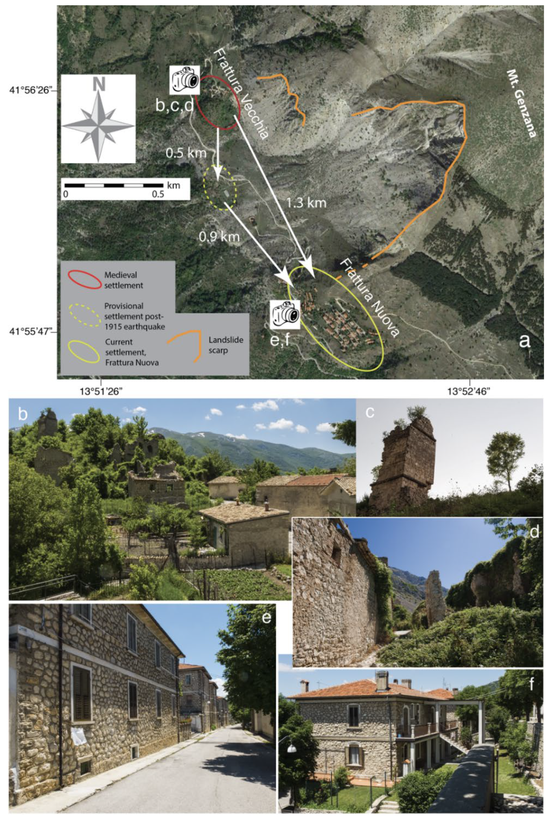
The medieval settlement of Frattura is located on the western slope of the Mt. Genzana carbonate ridge, close to the northern termination of the impressive landslide scarp related to the sudden collapse of rocks, which, damming the valley bottom, originated the Scanno Lake (hereinafter Scanno landslide; Figure 2a–d) [47,48,49,50,51,52]. Following the 1915 earthquake, a provisional village mainly made of wooden huts was built about 0.5 km south of the original settlement, in the locality known as La Ruccia (Figure 2a). A new village was finally located at about 1 km further south (Figure 2a,e,f).
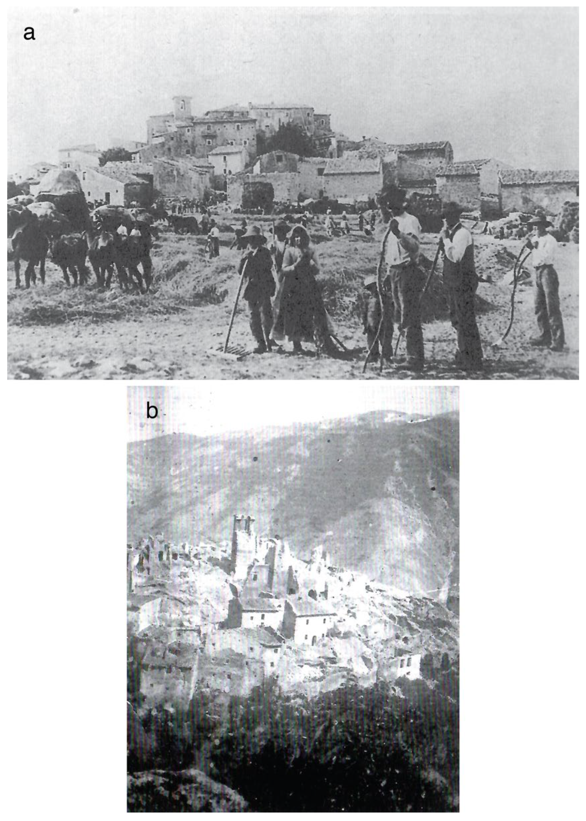
The migration of the built-up areas occurred within the Apennine environment, at about 1200 m a.s.l. The choice made by the residents to remain in the mountain environment was motivated by their necessity to maintain proximity with the land that represented the only source of sustenance (Figure 3a).
The 1915 earthquake caused significant damage to the medieval village (estimated as Intensity 10 MCS) (Figure 3b) and about 180 victims among the 400 residents. Damage was concentrated in the part of the village founded on the Paleogene carbonate hill, including the church of San Nicola. In contrast, the earthquake had minor effects in the part of the village located in the plain area between the aforementioned hill and the slope of Mt. Genzana.
After the destruction, the Decree of the King’s Deputy ruled the impossibility to carry out reconstructions and restorations in the same place of the historical built-up area. With a further Decree of the King’s Deputy (2 March 1916, no. 299) and applying the Law 9 July 1908 no. 445, Frattura was included in Table E of 1908, among the villages for which resettlement was considered necessary.
This choice was the consequence of the geological knowledge at that time. In the brief macroseismic description of the earthquake effects, dated 2 February 1915 and sent from the Municipality of Scanno to Ufficio Centrale di Meteorologia e Geodinamica at Rome (the Italian institution deputed to study earthquakes at that time), the village was defined as located close to a “sliding mountain”. In 1916, a technical commission of the Ministry of Public Works stated that Frattura was located on the debris of the Scanno landslide. The accumulation was considered to be still unstable, and the instability was the reason for the enormous damage caused by the seismic event.
Current data define a different situation. Landslide debris lies over the slopes (basal sectors) of the low relief where ancient Frattura was founded. The chaotic landslide material does not compose this small hill as supposed in 1916. The evidence that the entire relief is made of an unrooted rock block, as a consequence of a landslide older than that related to the impressive scarp of Figure 2a, can be derived from recent works [50,52] and no hypothesis about this process has been found in technical reports of one century ago.
The period following the earthquake, when people were partly living in the less damaged buildings of the ancient village and partly accommodated in the provisional huts of La Ruccia, was characterized by the choice of an area suitable for resettlement. Initially, the Decree of the King’s Deputy established reconstruction at about 1 km WNW from ancient Frattura. Residents considered the hypothesized location to be unfit for rebuilding the village and a new proposal was made by the Ministry of Public Works after further surveys of a technical commission, which included a geologist.
The area for resettlement was identified about 1.5 km south of the original village, in a sector of Mt. Genzana’s western slope characterized by low acclivity but being close to the steeper slope with clear geomorphological evidence of deep-seated gravitational deformations (DSGD; Figure 4a) [51,52]. These are probably the same geological processes that originated the Scanno landslide. This kind of gravitational phenomena was unknown at the beginning of the 20th century, considering that the research on DSGD significantly developed since the Vajont landslide of 1963. The chosen place is also characterized by a substratum made of cemented breccias, an aspect that made the area suitable for rebuilding. The thick breccia layers gently dipping towards the valley are the substratum of foundation for the buildings of the new village (Figure 4b).

3.1.2. Abandonment and Resettlement of Frattura

The provisional village, built after the earthquake by the Civil Engineering Office and a voluntary association, totaled 76 huts, prevalently made of wooden planks; few buildings were composed of masonry walls. Sparse evidence of this village is still detectable today: a fountain and a few remains of the rectangular podiums supporting the huts.
Although the Decree of the King’s Deputy forbade interventions in the damaged village, it remained for years as a reference for the resident population, giving shelter to about thirty families and livestock in few dozen less-damaged buildings.
Contrary to other cases described in the following sections, damaged walls were not demolished, although the local authorities also invoked interventions for public safety decades after the earthquake. Paradoxically, the Civil Engineering Office did not promote such actions, based on the rule imposed by the Decree itself. As the village was supposed to be abandoned, public safety could not be invoked to ask for interventions by the Ministry of Public Works. This is the reason why the remains of the old village are still present today.
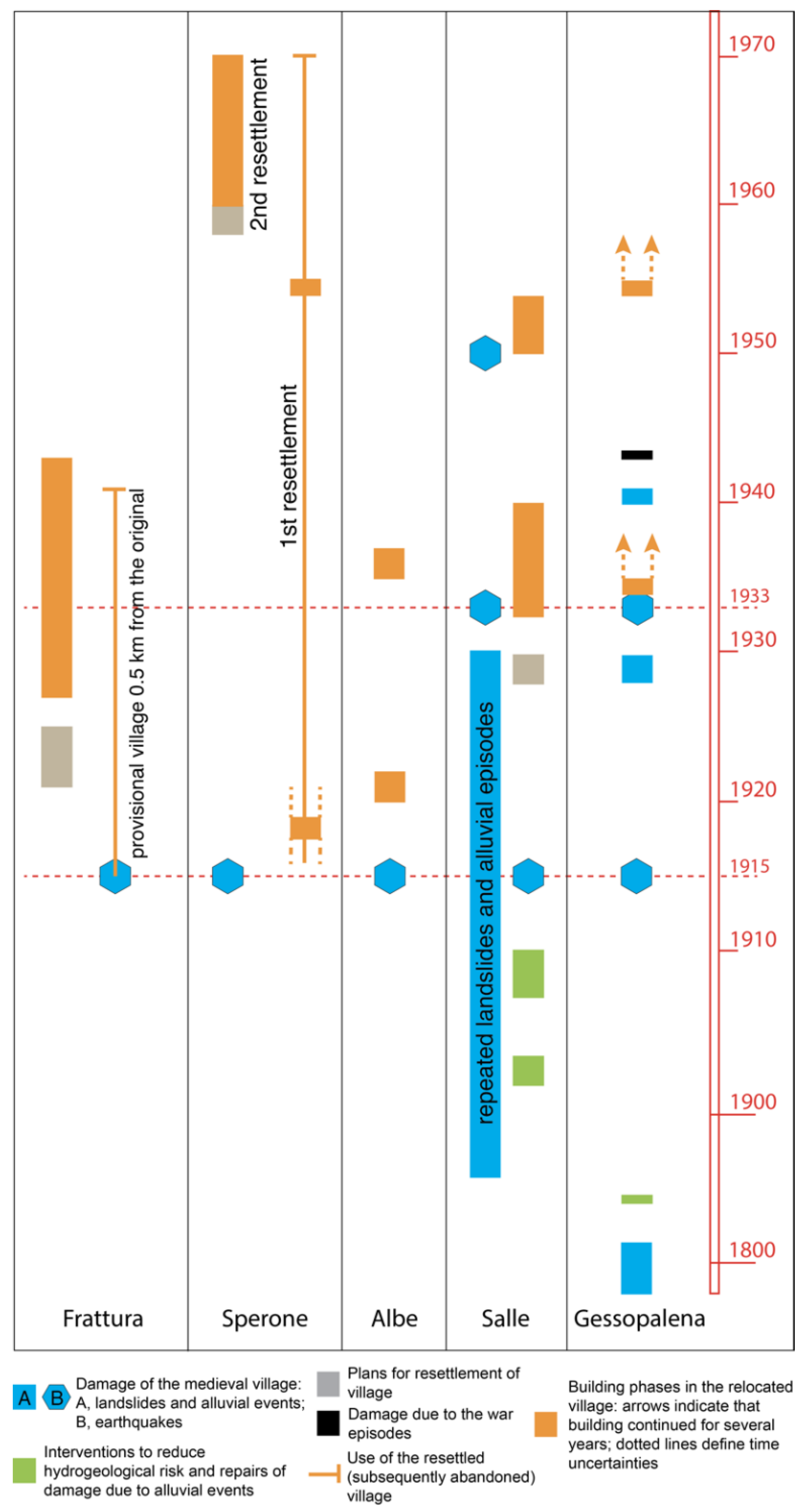
Field surveys to draw the master plan of Frattura Nuova were made between 1918 and 1923. A preliminary plan was available in 1921, while the final version was approved by the Ministry of Public Works on 30 July 1924. The delivery of some preliminary works (e.g., construction of roads, lifelines, retaining walls, etc.) to the building contractors is dated 17 April 1926. After lengthy periods of interruption, this first phase of the works ended on 20 October 1930; the final inspection is dated 4 April 1932.
Although a plan for the construction of the aqueduct was already available in 1923, following technical modifications and an update of prices, work began between 1936 and 1937. The construction of houses in the new village began before 1933 and three buildings were available at the end of that year. Their final inspection is dated 13 September 1935, but people did not occupy them until the construction of the aqueduct. The school was built in 1937 and further residential buildings were made available that same year (works ended on 5 November 1937, final inspection December 1938). On the whole, 48 apartments were available in May 1938. Works for an additional four buildings (24 apartments) began in 1939, ending on 15 June 1940. People were transferred and 72 apartments were occupied in March 1941. A further 24 apartments became available in September 1941. The building of the church was planned in 1939; works began in 1940, decorations and finishing touches are dated 1943, and electricity became available in 1950. The vicarage was built between 1940 and 1941.
During the period between 1936 and 1941, the population of Frattura was distributed in buildings of three different settlements, i.e., the remains of the original built-up area, the huts of the provisional village, and the new houses of Frattura Nuova. Some residents remained in the wooden huts at about 1200 m a.s.l. for 26 years.

3.1.3. Frattura Today

The ruins and some buildings still in good condition define the extension of the medieval village. Remains of walls can be identified on the hill of the historical settlement, abandoned and enveloped by vegetation (Figure 2b–d), e.g., the bell tower of the church of San Nicola showing a tie beam expelled from the wall and suspended in the air. A few houses that suffered minor damage in 1915, located in the plain area near the slope of Mt. Genzana, were restored in recent decades and their outer walls are presently in good condition (Figure 2b). The small church of San Rocco, used for religious services after the 1915 earthquake, is also among the buildings that benefited from continuous maintenance.
As opposed to other villages resettled after natural catastrophes, today, Frattura Nuova still shows the orderly layout that was planned almost a century ago, with the same buildings of the 1930s displaying a surprising pleasantness: the peculiarity of the choices adopted to exploit the gentle slope (i.e., houses with one floor or two upslope and two or three floors downslope), the regular forms of the buildings far from styles typical of social housing, and the wall façades made of stones close to the tradition of the Apennine buildings (Figure 2e,f).

3.2. Sperone

3.2.1. Geomorphological and Geographical Frameworks

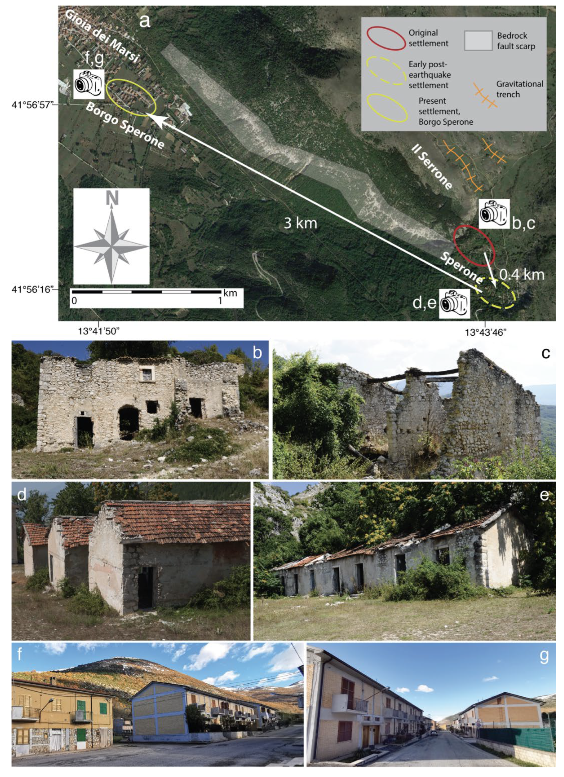
The remains of the medieval rock settlement of Sperone are located along the SE margin of the Fucino basin, at about 1200 m a.s.l., at the southern termination of the Serrone carbonate relief (red ellipse in Figure 5a–c). Known since the 12th century AD, it is dominated by the cylindrical tower from the 13th century, representing a peculiar visual cue from the SE sector of the Fucino Plain. This typical Apennine village, included in the municipality of Gioia dei Marsi since the 19th century, had just over two hundred inhabitants in the second half of the 19th century, and about 150 at the beginning of the 20th century.
The 1915 earthquake caused serious damage to the ancient village, presently estimated as Intensity 9–10 MCS. The subsequent Decree of the King’s Deputy forbade reconstruction in the same place of the ancient built-up area, and in the “adjacent detrital and clayey zones”. Conversely, it defined an area suitable for resettlement about 250 m SE of the original village, characterized by an almost planar land surface carved into the carbonate bedrock. Resettlement did not exploit this area, since the new village was built about 150 m further SE (yellow dashed ellipse in Figure 5a,d,e).
The current geological knowledge indicates that the main natural criticality in the foundation area of the original village was not the “detrital and clayey zones”. Today, the juxtaposition of the ancient buildings to the surficial expression of the southernmost segment of the 1915 causative fault is well-known and easily detected by looking at the western slope of the Serrone carbonate relief [53,54,55,56] (Figure 5a). This aspect of geological hazard was unknown at the beginning of the 20th century. Only in recent years has attention for the relationship between built-up areas and capable faults increased, assuming a mandatory role in planning the land use, through the seismic microzonations [57]. Since buildings of ancient Sperone are very close to the fault, their reconstruction today would have been strongly conditioned by the results of specific studies on the position of each splay composing the fault zone. The evidence of deep-seated gravitational movements east of the Serrone relief adds to that of the active and capable fault (Figure 5a). Recent deformations can be attributed to lateral spreading phenomena, related to an extension perpendicular to the axis of the relief that generated the small NW-SE trending valley depressions located north of the village [58]. Investigations with paleoseismological techniques (i.e., through excavations of trenches perpendicular to the main shear planes bounding the valleys) defined displacement events that also occurred during the Late Holocene [58]. In short, this area was geologically unsuitable for the foundation of a safe village, although the original buildings were founded in the apparently solid carbonate bedrock.

3.2.2. Abandonment and Resettlement of Sperone

After the earthquake and according to the constraints imposed by the Decree of the King’s Deputy, resettling generated a new village (dashed ellipse in Figure 5a), which, as opposed to the shanty town of Frattura, was supposed to represent a final residential location. As in the previous case, and within a comparable environmental and social framework, Sperone also experienced resettlement at an altitude of about 1200 m a.s.l.
A few years after the earthquake, i.e., not later than 1922, reconstruction followed the traditional plan of regularly distributed small one-story buildings, with a frame of reinforced concrete and infills of stones, covered by gable roofs with interlocking tiles (Figure 5d,e).
The history of the new village is summarized in archival documents from the 1950s. A Civil Engineering Office report indicates that a plan for a transfer to a location closer to the Fucino Plain was offered by the authorities, explicitly stating that modern times were different from the Middle Ages, when the settlement on a rocky hill was necessary for historical and political reasons. However, the population deliberately decided to remain in the proximity of the ancient village, at the same altitude. The choice had economic reasons, since the residents lived by exploiting the adjacent land and a drastic resettlement would have created problems of livelihood.
As in the case of Frattura, the damaged buildings of the ancient village were prevalently used as housing for livestock. Moreover, at least nine families were still living in the decaying buildings of the original village in 1959. Archival evidence of this continuity of life is confirmed by the insertion of walls attributable to the 20th century in some pre-existing buildings [40].
Decades after its foundation, the post-1915 built-up area still presented problems that afflicted the residents. For example, the church was external to both the old and the new village and was still damaged decades after the earthquake. This difficulty, already denounced by the parish priest in 1917, persisted until the building of the new church in 1954. As was the case for the school, the only classroom was accommodated in one of the residential buildings. Only in 1955 was the place for the new building selected in the NE sector of the built-up area. In that same year, the plan for the new school, drawn by the Civil Engineering Office, was sent to various institutions for approval. In 1957 the acts were still lying in that office and, due to issues arising from the legislation of that time, the plan was abandoned. A convenient road connecting the village and the local highway was only built in 1954. Moreover, during the 1950s, the lack of electricity and a telephone line, the malfunctioning of the aqueduct, and the bad conditions of the small residential buildings (considered to be very deteriorated by ageing) made the residents’ daily life very complicated.
Other perspectives were maturing in that period. The residents’ choice of forty years before was contested, especially by the municipal administration, which, apparently, was directly acknowledging the necessities of people still living in Sperone. The current situation was dramatically represented to various institutions. The territory of ancient and new settlements was depicted as a place characterized by modest pastures, inappropriate for human residence. The initiative was propaedeutic to more radical actions, as in 1958, when the municipal administration sent a further document to some ministries, explicitly asking for the relocation of people from Sperone to Gioia dei Marsi. The document described the long-term consequences of the choice made in 1915, with emphasis on the quality of life and the social conditions similar to those of primitive men, revealing the repentance of the inhabitants for the decision made decades before and their request for interventions by administrative and government authorities to define another location for their houses.
The situation was considered no longer sustainable in 1959, when the municipal administration defined a plan for a further village, close to the Fucino Plain, i.e., at an altitude 500 m lower than the places inhabited so far and a few hundred meters south of Gioia dei Marsi (yellow ellipse in Figure 5a). Reference for new planning was a specific law for the “elimination of the insalubrious houses”, among which the small buildings following the 1915 earthquake were included. The new layout was typical of public housing, with two-story row buildings far from the traditional Apennine architectural style (Figure 5f,g).
The history of the new settlement, Borgo Sperone, began with this plan at the end of the 1950s. This further village was located at 11 km (following the local highway) from the preceding settlements. Building of a first lot of houses began during the summer of 1960. The final engineering tests were made in April 1963 and the new houses became available in February 1964. The complete or partial demolition of three post-1915 buildings was carried out in subsequent months, leaving a space within the regular layout of the abandoned village of the 20th century. Although the transfer of inhabitants continued during the 1960s, together with the progress of new building in Borgo Sperone, no further demolition was conducted in the abandoned village. The transfer of inhabitants ended in 1971, thus concluding a period of about seven years during which the population was divided between post-1915 Sperone and Borgo Sperone.

3.2.3. Sperone Today

Once the relocation of the residents was completed at the beginning of the 1970s, the preceding settlements progressively assumed the forms of the abandoned places.
A century after the earthquake and decades after the definitive abandonment, the medieval settlement shows the typical aspect of the ruined site (Figure 5b,c). Remains of walls are distributed along the steep slope, some still connected by degraded wooden beams. Roofs are missing, together with ornaments on the façades and portals, systematically pulled out of the walls in previous decades. As usual, most of the village had been colonized by vegetation.
Concerning the post-1915 village, many abandoned buildings are presently in ruins (Figure 5d,e); the roofs are in some cases missing (Figure 5e); the interiors of houses are filled with rubble, garbage, and remains of furnishings; and rooms are colonized by arboreal and shrubby vegetation. The church, completely devoid of the interior decor, is frequented by individuals with fanciful artistic ambitions. At least one of the small houses has been left in the original conditions by its owners, with the furniture of decades ago, giving tangible evidence of the lifestyle during the first half of the 20th century.
This previously inhabited territory, with the multiform material evidence of settlement related to different ages, had not been the object of special care by territorial administrations until now. In 2015, during the centenary of the earthquake, some attention was dedicated to the geological aspects, by creating a geosite centered on the Serrone fault, as a local manifestation of the 1915 causative fault [56]. A geological tourist map was also drawn, particularly to feed the historical memory of the 1915 earthquake and to increase awareness of seismic hazard [56]. However, more could be done and promotion of this peculiar territory will be addressed again in the discussion.
The new Borgo Sperone is located at the base of the Serrone relief. The settlement is no longer close to the fault, although the residents can easily recognize that geological feature by simply casting a glance to the mountain. The village is characterized by the typical style of the planned social housing, with buildings regularly distributed along a minor road (little more than two hundred meters long) parallel to the local highway (Figure 5f,g). This anonymous built-up area, completely extraneous to the Apennine building tradition, represents the final act of the complex history of Sperone summarized here.

3.3. Albe

3.3.1. Geomorphological and Geographical Frameworks

The settlement of Albe, founded on the San Nicola carbonate hill (about 1000 m a.s.l.) dominated by the impressive castle now in ruins, is historically documented between the 10th century AD and the beginning of the 20th century, when it was almost razed to the ground by the 1915 earthquake (Figure 6).
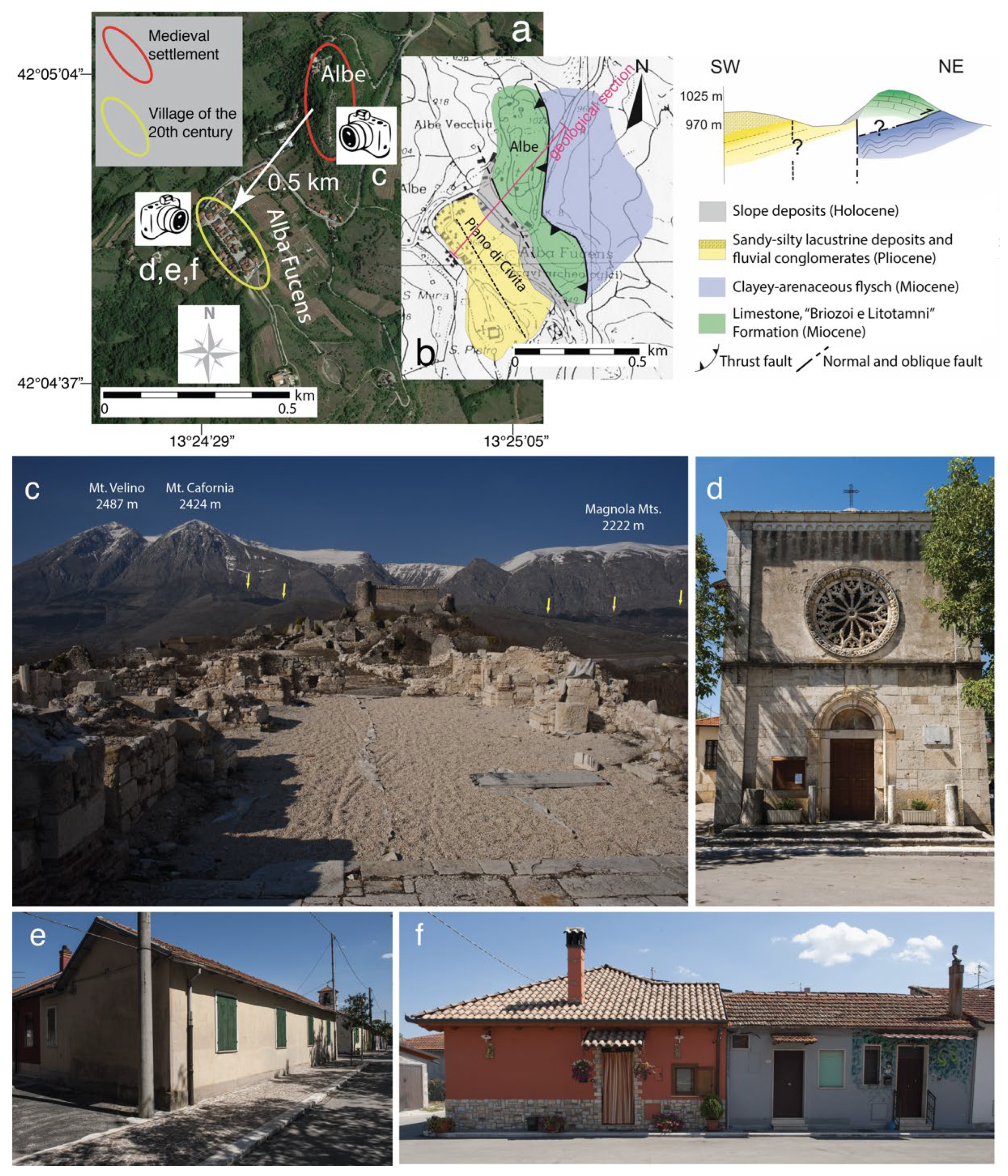
The medieval settlement followed the abandonment of the adjacent Roman town of Alba Fucens, founded in 303–302 BC within the framework of the progressive Roman conquests towards the Adriatic Sea. Most remains of Alba Fucens have been archaeologically uncovered in the small valley east of the San Nicola hill, known as Piano di Civita, representing the most important sector of the ancient town and the current main archaeological area (Figure 6a,b).
Even the history of Alba Fucens is related to natural events. After centuries of prosperity, the ancient settlement declined during the late antiquity. A destructive earthquake, currently attributed to 484 or 508 AD, is considered to be one of the events that strongly conditioned the latest period of Alba Fucens. The archaeological literature, based on data from excavations between 1949 and 2020, reports widespread evidence of the destruction [59]. Occupation of Piano di Civita and use of the remains of the ancient town continued after the catastrophe probably until the Early Middle Ages, when the valley was progressively filled by sediment derived from repeated episodes of mass deposition. This has been documented by geoarchaeological investigations on the colluvial sediments covering the archaeological remains [59]. The sediment deposition fed from the adjacent unstable slopes was presumably one of the reasons for the foundation of the medieval village on the San Nicola rocky hill (red ellipse in Figure 6a).
The few available images of Albe preceding the 1915 earthquake show the typical picturesque Apennine village with no more than some three-story buildings made of badly laid calcareous stone masonry (Figure 7). The main road was perpendicular to the façade of the church dedicated to San Nicola (Figure 7b). The photograph shows the simple structure of this building, with the façade dominated by the beautiful rose window.
Albe was founded in the Miocene carbonate rocks (Figure 6b), outcropping throughout the remains of the built-up area [60]. As opposed to Sperone, the fault that caused the earthquake does not cross the village. However, it is not far (about 5.5 km) and the bedrock scarp with the fault plane exposure is easily detectable, looking from the San Nicola hill at the southern slope of Magnola Mts. and Mt. Cafornia (Figure 6c). The geological structure of the hill is in turn conditioned by the presence of two other minor faults (Figure 6b). A normal fault was detected along the western slope (i.e., on the flank of Piano di Civita valley), which places the carbonate rocks in contact with the Pliocene silty-sandy continental deposits. Although it is related to tectonics within the ongoing Apennine extensional regime, evidence of Late Quaternary activity has not been detected and the fault is considered inactive. The eastern slope is instead characterized by the presence of a thrust, resulting from the old Cenozoic compressive tectonics, responsible for the superposition of the Miocene calcareous rocks over the Miocene clayey-arenaceous flysch (Figure 6b) [60]. Based on this structural framework, which is different from other Apennine rock settlements, Albe was founded on unrooted carbonate bedrock. This aspect may make this case comparable to that of Frattura, although the structural-geological condition resulted from different processes, i.e., tectonic for the former and related to slope instability for the latter.
The structural anomaly presumably conditioned the seismic history of the medieval village. The buildings of Albe did not stand the test of the 1915 shock and the destruction of the village was almost complete, as indicated by the attribution of Intensity 10–11 MCS [26]. Destruction was the consequence of building vulnerability but also of the site effects that affect the carbonate hill, estimated during seismological surveys (directed by A. Pagliaroli, University of Chieti, Chieti, Italy) by means of ambient vibration measurements using the HVSR technique [60]. The H/V curves (based on the Fourier amplitude spectral ratios between the horizontal components (H) of the ground motion with respect to the vertical component (V)) identified two peaks, at 2–3 Hz and 6–9 Hz, respectively, both characterized by significant amplitude between 4 and 6 (diagrams are included in [60]. Results of this investigation suggest that the hill of Albe suffered a strong amplification of the seismic motion in 1915.

3.3.2. Abandonment and Resettlement of Albe

As for the geological condition mentioned above, the Decree of the King’s Deputy could not consider the evidence of the site effects derived from modern seismological surveys. For this reason, probably because of the foundation on carbonate bedrock, the Decree allowed rebuilding in the same place as the original village.
However, the heap of rubble inhibited reconstruction on the San Nicola hill. A report of the Civil Engineering Office of 16 June 1915 defined the demolition of 50 houses as necessary. The almost complete destruction suggested that residents abandon the place, as indicated by a newspaper (“Il Giornale d’Italia”) of 21 January 1915: “the few survivors do not plan to come back among these ruins, and therefore the modern village is destined to disappear as the ancient glorious Roman town […]”. Contrary to other cases, inhabitants immediately abandoned the remains of their village and, in a sort of historical full circle, the 20th century resettlement involved the area of Roman Alba Fucens, with buildings adjacent to the present archaeological area (yellow ellipse in Figure 6a).
After the earthquake, attention to the medieval village was motivated by the necessity to recover some artistic masterpieces, buried within the ruins of the church. These works, especially a famous 14th century triptych with Virgin and Child, a 14th century ivory triptych with Virgin and Angels, a 13th century silver reliquary, and 15th century silver processional crosses, were extracted from the ruins by means of excavations concluded at the end of March 1915. Some of the most important pieces were transferred to Rome by the Ministry of Education of that time and displayed in the Museum of Palazzo Venezia [61].
With respect to the new village, after a few years, the temporary accommodations were replaced by the typical post-catastrophe small buildings, already seen in the case of Sperone (Figure 6e,f). A first group of such buildings was made available on 26 May 1920. On the whole, rebuilding of the village needed the expropriation for public use of almost 7500 m2 of soil. The construction of the school was already planned in 1920, the necessary land was expropriated in 1922 and the building was certainly constructed in 1928. The plan for the building of a new church of San Nicola was ready in 1925. In 1935, this was replaced by a new plan to redraw the façade to include the portal and the rose window of the original church, recovered after the destructive earthquake (Figure 6d). The building was certainly completed at the beginning of 1938, when the parish priest requested that the Ministry of Education return the masterpieces of sacred art belonging to the church. The restitution never occurred. Presently, the processional crosses are still in the Museum of Palazzo Venezia in Rome, while the triptych with Virgin and Child and that with Virgin and Angels are relatively close to Albe, in the Museum of Sacred Art at Celano (about 18 km from Albe) and in the Diocesan Curia of Avezzano (about 9 km from Albe), respectively [61].

3.3.3. Albe Today

The modern village still displays the regular distribution of the small houses built a few years after the earthquake. Some of them still have their original form, thus representing material evidence of the post-1915 resettlement, while in a few cases, significant or radical changes are evident between superfetation and complete rebuilding of the previous decades (Figure 6e,f). The new church of San Nicola dominates the square that interrupts the rows of small buildings, and the portal and the rose window of the ancient church are material evidence of the centuries-old history of the original settlement (Figure 6d).
The ruins of the 1915 destruction remained untouched for almost a century on the hill of the medieval village. The heap of stones became part of the relief and were colonized by vegetation. Decades after the earthquake, Albe was an interesting example of the so-called “third landscape”, i.e., a geographical area that experienced transformation of the natural environment to meet human needs and, following the abandonment, was transformed again through a new assimilation by nature [62].
The evolution of the “third landscape” at Albe ended in the first decade of this century, when a plan to rebuild the original village for residential purposes (already preceded by the reconstruction of a few buildings to provide hotel accommodations) required archaeological excavations and removal of the ruins. In 2007, during excavations close to the ancient church, human remains of the last missing person of the 1915 earthquake were found [45]. Contrary to original plans, rebuilding never occurred. In contrast, these interventions created a new landscape, including a significant remnant of the medieval village, made of remains of buildings and walls that are still standing. On the whole, this represents surprisingly fresh and impressive evidence of the 1915 earthquake effects (Figure 6c). The current remains of Albe give a sort of archaeological image of the destruction of more than one hundred years ago. Standing in the nave of the church, only made of the floor and the sparse remains of the outer walls, a visitor may reflect on the power of an earthquake’s shaking or about the excavations through the ruins in the days following the earthquake to recover the masterpieces of sacred art. From the same place, looking north, towards the Magnola Mts., the grey ribbon defining the surficial expression of the 1915 causative fault can be easily recognized in the distance (Figure 6c).

3.4. Salle

3.4.1. Geomorphological and Geographical Frameworks

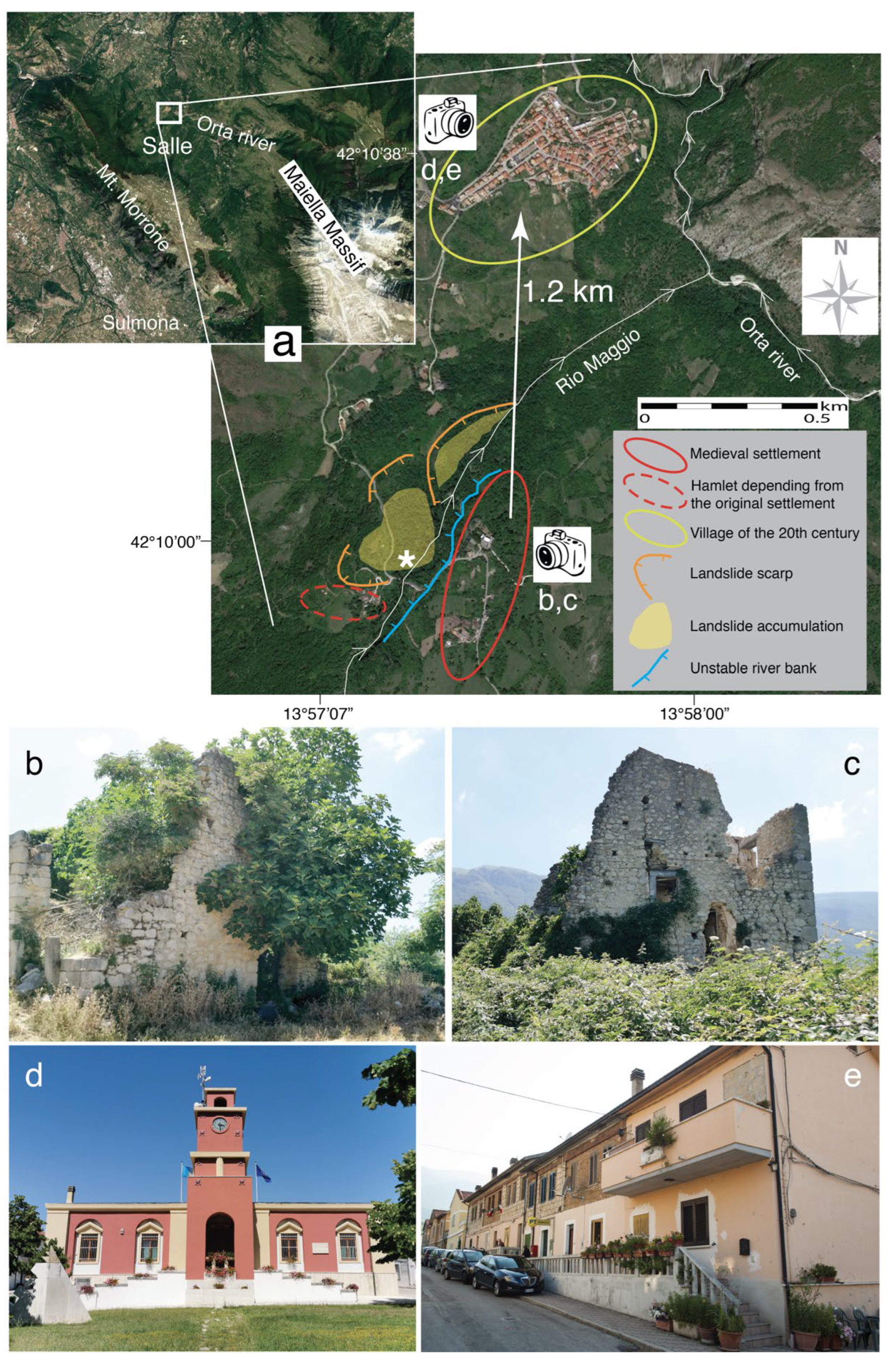
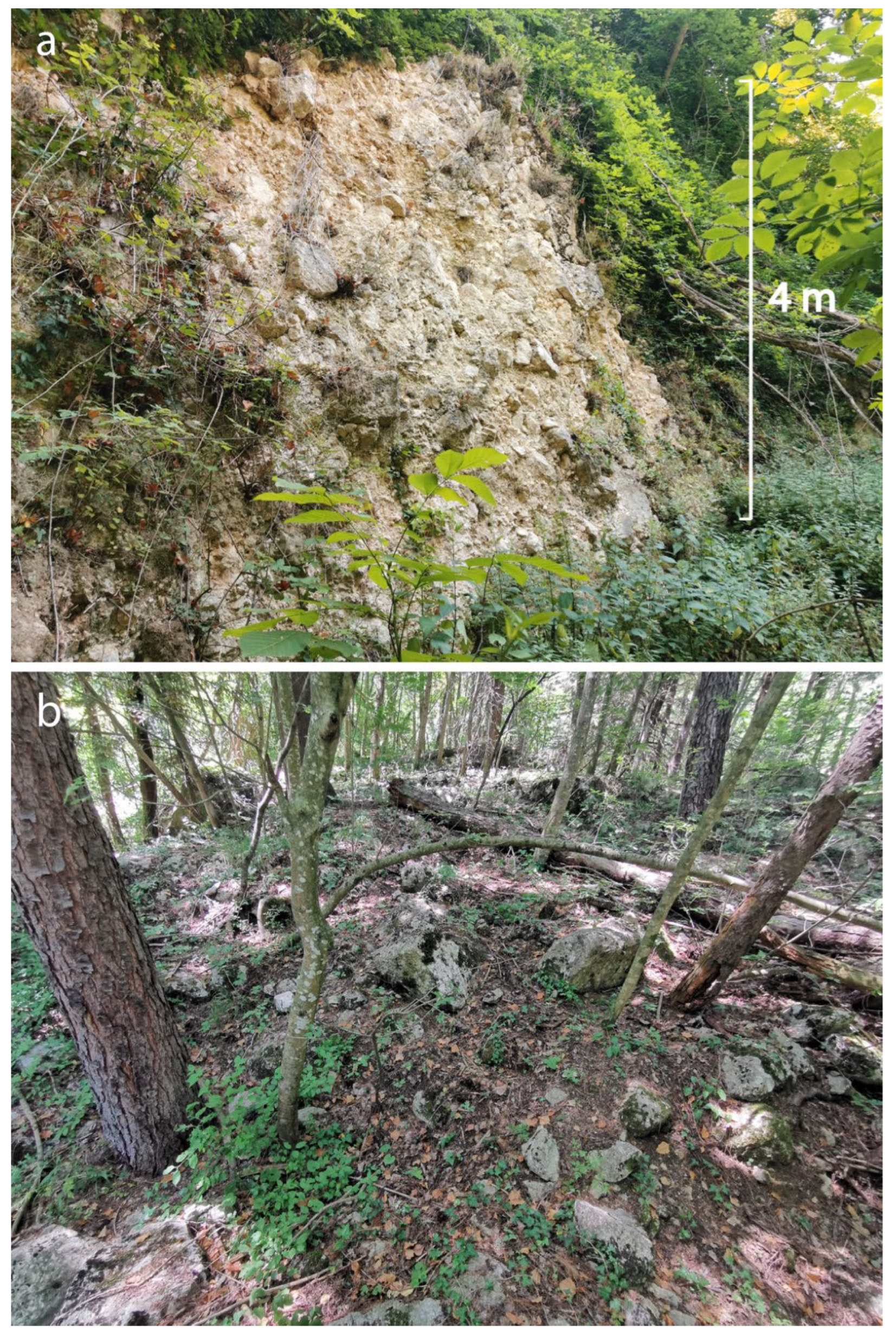
Both villages (the one currently inhabited and the ruined settlement) are located in the lower sector (about 450–550 m a.s.l.) of the NE slope of Mt. Morrone (Figure 1a and Figure 8), a carbonate ridge reaching 2000 m a.s.l. The local geological framework derived from the Miocene-Pliocene compressive tectonics, which structured the slope by pervasively distributed NW-SE trending thrust faults that displaced the Mesozoic-Cenozoic carbonate units and the Miocene clayey-arenaceous flysch, and by NE-SW vertical tear faults [63]. During the Quaternary, the slope fed (and is still feeding) huge amounts of landslide and detrital accumulations, made of carbonate clasts in a sparse matrix of fine-gravel grain size, representing the foundation soils of both old and new Salle (Figure 9a) [63].
The original settlement (red ellipse in Figure 8a) had the typical layout of the Medieval Apennine villages, with the castle, probably built during the 10th century [64], and the church as reference buildings. It had a dominant position over a wide sector of the valley incised by the Orta river, a tributary of the Pescara river draining towards the Adriatic Sea (Figure 1a and Figure 8a). More in detail, Salle was located on a terrace of the right flank of Rio Maggio, a deeply incised stream with a four-kilometer-long course and a tributary of the Orta river. The map of landslide hazard [65] defines an area characterized by instability phenomena, which may reactivate or are considered to be active (P2 and P3 classes of hazard) in the upper course of Rio Maggio. The landslide risk is considered moderate (R1), since social and economic losses would be marginal in case of landslide activation [66]. Moreover, the flanks of the stream close to the ancient village are labelled as areas characterized by instability phenomena caused by scarps [65]. The Inventory of Landslide Phenomena in Italy (IFFI, https://idrogeo.isprambiente.it/app/iffi/r/13?@=42.16738400595622,13.971272136536898,12 accessed on 30 July 2022), produced by ISPRA, Istituto Superiore per la Protezione e Ricerca Ambientale, defines an area of slow earth flow phenomena along the right flank of Rio Maggio, including the site of the old village. According to the same inventory, the new settlement is also characterized by adverse geological conditions, i.e., a slow earth flow on the southern slope of the terrace where the village is founded and a rotational translational slide along the NW slope.
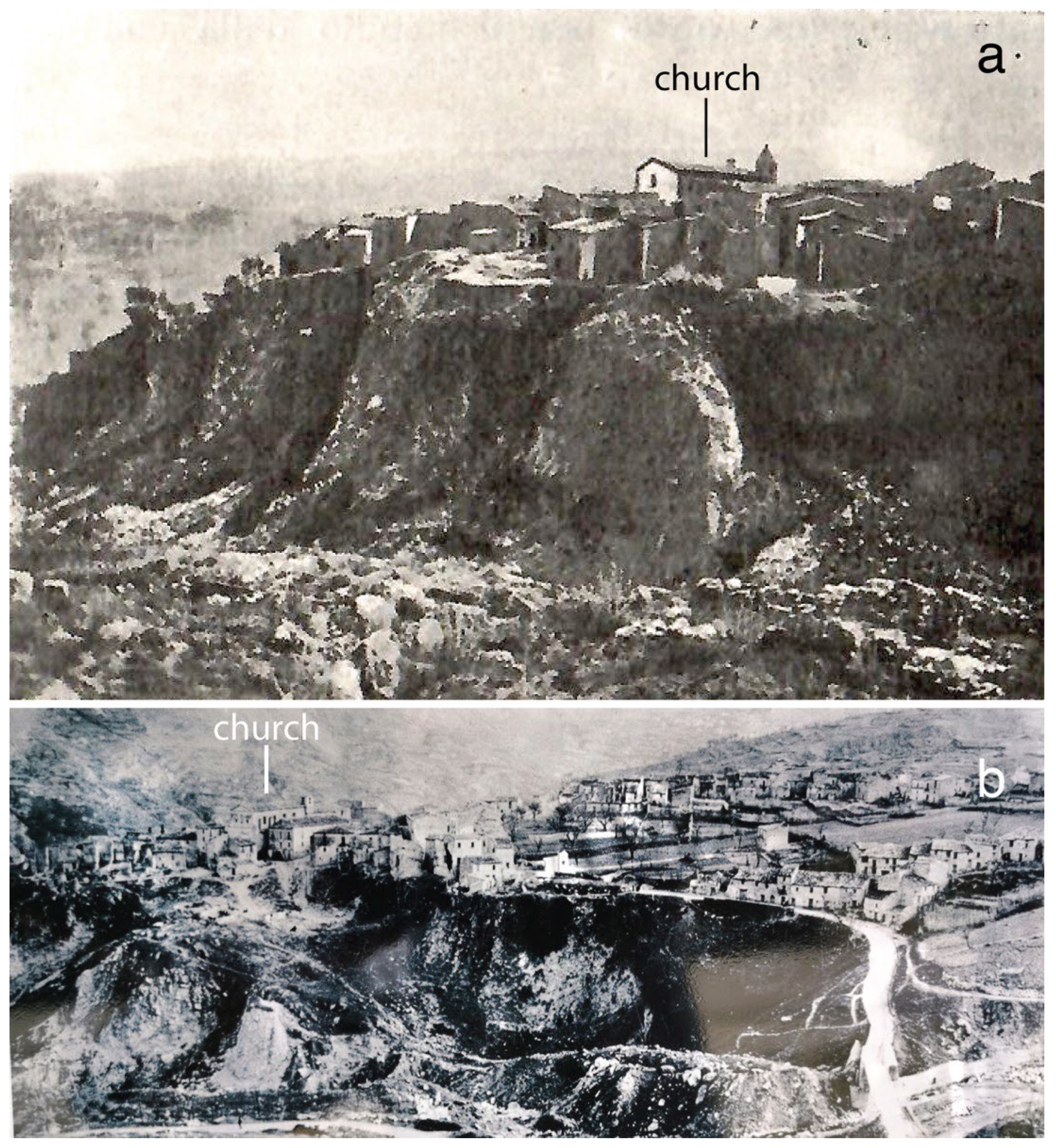
Less recently, the slope instability in the Salle area was investigated within the framework of the regional landslide phenomena [67]. A sketch of the local instability was also proposed, with a main landslide scarp on the left flank of Rio Maggio, west of the historical settlement (corresponding to the southernmost landslide scarp among those represented in Figure 8a), and the related accumulation within the valley (Figure 9b). With respect to ancient Salle, the main problem derived from the collapse of the right stream bank (blue line in Figure 8a). According to Almagià [38], The historical activation of this kind of instability occurred in 1870, due to fluvial erosion of the stream bank where Salle was founded, with the consequent collapse of buildings. This famous geographer also published a panoramic photograph of the right bank of Rio Maggio, showing the proximity of the buildings to the unstable edge of the terrace (Figure 10a; a more recent photograph, Figure 10b, shows the evolution of the built-up area close to Rio Maggio). Moreover, Almagià also mentioned the landslide on the left bank of Rio Maggio mapped by Buccolini and Sciarra [67], which, in 1905 ( reported as February 1906, in the historical sources; see also D’Andrea [39]), damaged the bridge over the stream. The accumulation shifted the stream course towards the right bank, forcing further erosion in the area of ancient Salle.
Aerial photographs from 1945, shot by Istituto Geografico Militare, give a thorough view of the instability phenomena, since the area was completely devoid of vegetation at that time. The landslide scarp on the left valley flank is easily discernible, together with the vertical right bank of the stream from which collapse episodes had originated, causing the destruction of buildings (Figure 8a). These aerial photographs indicate that the instability affected the right bank for a length corresponding to the entire western sector of ancient Salle, i.e., a large portion of the village was threatened by collapse. Moreover, further evidence of instability along the left bank of Rio Maggio can be collected (Figure 8a), which adds to that sketched by Buccolini and Sciarra [67]. By accumulation in the valley bottom, all these phenomena forced the river course and related erosion towards the right bank of the stream.
In short, the stream erosion of Rio Maggio and the deepening of the valley bottom originated the instability of the right bank where Salle was founded. This process was worsened by the landslide motion of the left valley flank, which forced the stream course towards the area of the village. Letters from the Civil Engineering Office of Chieti depict the seriousness of the situation in 1910, since the width of the channel was, in some places, reduced to 1 m from the original 8 m.
According to Almagià [38], collapses on the right bank of the stream occurred (and damaged Salle) in 1870, 1873, and 1897. However, historical documents (mainly meeting reports and resolutions of the local City Council) mentioned in D’Andrea [39] indicate that building destruction due to landslide already occurred in 1858 and that in 1869 several houses showed clear evidence of damage. Other extreme events, with the excess of stream flow and related erosion of the right bank, occurred in 1876, 1877, 1883 [39], and 1910 (correspondence between the Ministry of Public Works and the Civil Engineering Office of Chieti). According to historical sources, intense erosion and related slope instability was caused by deforestation on the western slope of Mt. Morrone, particularly during the 19th century [39] (see [68] for another comparable case in the Abruzzi region).

3.4.2. Abandonment and Resettlement of Salle

During the second half of the 19th century and at the beginning of the 20th, actions for the defense against extreme hydrogeological events were planned to mitigate the risk at Salle. These are the result of the intention to maintain the village in the original location. For example, stream diversion was proposed, together with reforestation in the places previously deforested [39]. Documents from the Civil Engineering Office of Chieti refer to plans drawn in 1879 and 1901 to mitigate the hydrogeological risk. The latter plan hypothesized widening the riverbed, building drainage works to mitigate the slide hazard along the left valley flank, and building five dykes within the stream bottom and a large wall along the right bank. However, since funding was insufficient, expected works were partially conducted between 1902 and 1904. Funds for further works were requested by the municipality of Salle in 1909 to the Minister of Public Works. From correspondence between the prefect and the Civil Engineering Office, we know that the provisional bridge over Rio Maggio, rebuilt in 1907 after the serious damage of the 1906 landslide in the left valley flank, collapsed again in 1909 for the landslide reactivation, interrupting the communication with other villages and the main towns of the region. Subsequently, in 1910 (18 June), the provisional wooden walkway used to cross over the stream was also removed during a flood.
On the whole, plans and actions at the beginning of the 20th century were aimed at increasing the safety of the old village. However, in the meantime, the Italian Government had passed the already mentioned Law 9 July 1908 n. 445, with Table E including Salle among the built-up areas to be relocated.
The 1915 earthquake caused significant damage to the village, similar to that suffered by nearby localities, and is presently evaluated as Intensity 8 MCS [26]. Damaged houses were replaced by provisional huts. However, the situation in the village became critical at the beginning of March, since the instability of the right stream bank appeared as worse than before the Civil Engineering Office. Consequently, for the first time, the Office suggested resettling Salle elsewhere. The situation suddenly evolved on 25 May, when part of the right bank collapsed, carrying away several buildings and increasing the number of homeless persons, as indicated by the report of the Civil Engineers. According to the meeting report of City Council dated 7 October 1915 [39], earthquake and slope instability almost entirely destroyed Salle, since only 44 houses of 351 were considered safe in the village, together with 14 of 107 farmhouses. The situation deteriorated in November 1916, when the right flank of Rio Maggio experienced a new collapse.
Archive documents indicate that some repairs were made to damaged houses also at the beginning of the 1920s, although the hydrogeological threat was continuous. During the winter of 1930–1931, further alluvial episodes of Rio Maggio broke the old aqueduct. Repairs were planned in 1931 and interventions made in 1932.
Finally, significant damage to the old village was caused by the 1933 earthquake, presently estimated as Intensity 8 MCS, defining effects at Salle to be worse than those recorded in nearby villages, which were generally characterized by Intensity 7 MCS [26].
However, already in 1928, the Civil Engineering Office had drawn the city plan for the foundation of the new village about 2 km from the old one (yellow ellipse in Figure 8a). The final version was available in 1929 and that same year the executive project for building new roads and the sewage system was drawn. After some changes to the plan, roads, sewage system, aqueduct, and 14 residential buildings (46 apartments) to give shelter to homeless persons were built from 1932–1936, and public works continued in the following years. More in detail, the construction of residential buildings began immediately after the 1933 earthquake, based on a first plan dated 6 October 1933. Residents benefited from state funding, covering the total reconstruction costs, but they were required to demolish the property in the old village, as imposed by the law of 1908. This condition caused static problems to the buildings still occupied, adjacent to those pulled down. In February 1935, the new settlement had 150 inhabitants (31 families), but works were in progress and an additional 57 families were soon expected from the old village. Inhabitants rose to 200 in June 1935, with 16 more families ready to change their residence. Works for residential buildings were divided into four lots (1934, 1935, 1938, and 1939) for a total of 110 buildings. Therefore, construction of houses continued in 1936, together with the construction of the church, the school (both in the period from 1936–1937), and the town hall (1937–1938). At the end of 1939, about half of the population of Salle was living in the new village. Further private construction occurred in 1940, when works were undertaken for seven residential buildings. In July 1940, 76 houses were available of the 110 planned.
Abandoned remains in bad static conditions suffered further collapses in the old village due to intense rain and snow in 1940. However, reconstruction of the new Salle village and demolition of buildings in the progressively abandoned built-up area were interrupted during the Second World War.
The procedures for the reconstruction of Salle started again in 1948, when half the population was still living in the old village without drinking water, a sewage system, electricity, a school, and a district doctor, and were threatened by the collapse of the building remains. Problems were solved by completing the works of the master plan, completing new constructions, and transferring inhabitants during the first half of the 1950s. Aerial photographs of 1945 show that the building of the new village was still incomplete at that time and only limited to the central part of the current layout. In contrast, aerial photographs of 1954 show a distribution of buildings comparable to the present one, i.e., construction of the new settlement was at that time concluded. However, another earthquake occurred in that period, adding damage to the already ruined ancient village, i.e., the seismic event of 5 September 1950, reported in the CPTI15 catalog as “Gran Sasso”, Mw 5.7, with an epicenter located more than 50 km north of Salle [15]. Damage has been estimated as Intensity 7 MCS [26] and according to the newspaper “Il Giornale d’Italia” of 17 September 1950, 58 houses were considered unusable.

3.4.3. Salle Today

The new village had its final and present form within the mid-1950s and was based on the plan drawn at the end of the 1920s. The town layout appears as an application of criteria typical of the fascist period, with a main road and the public buildings (church, school, and town hall) giving onto the square in central position, and residential buildings distributed along main road axes (Figure 8d,e) [69]. This layout is considered to be devoid of identity, with respect to the original and abandoned village, since a true reference place acting as the physical and ideal heart of the entire settlement is missing [40]. The straight and wide roads along which buildings are distributed give the feeling of staying in a town suburb more than in a village with the peculiar Apennine character. The use of materials and building techniques far from those that are typical of the historical mountain villages does not contribute to constructing a sense of place [40]. Finally, the efforts to found and develop Salle Nuovo during several decades of the 20th century did not avoid the significant demographic decline common to the Apennine region. In the decades following its completion, the new village passed from 1100 inhabitants in the 1950s to approx. 300 residents today.
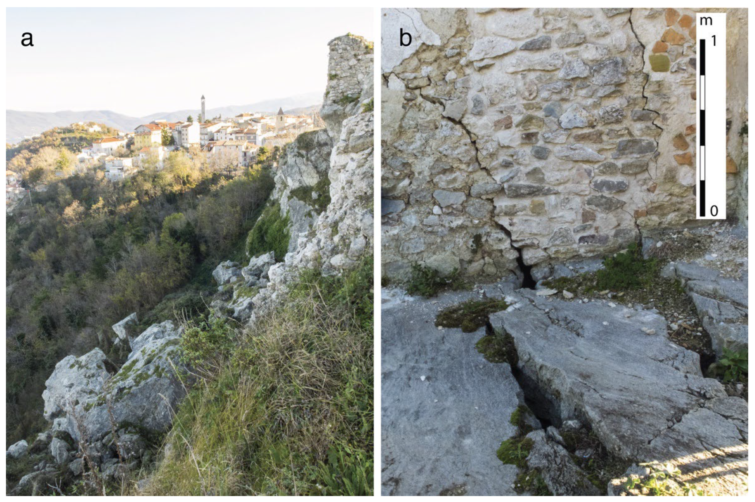
Concerning the original village, the castle was the object of a debatable restoration during the 1990s [40] and presently it is the location of an historical museum. Few other buildings have been recently restored for temporary residents. For the rest, evidence of the abandoned built-up area is only represented by sparse remains of buildings (Figure 8b,c) and of outer walls emerging for less than a meter, whose philological meaning is uncertain, as they probably do not precisely represent the geometry of the old houses distributed in close proximity to the castle. Paradoxically, more vestiges of the past settlement, though completely enveloped by vegetation, could be found in the hamlet close to ancient Salle, known as Recinto (dashed red ellipse in Figure 8a), deriving from the same municipality. The collapse of entire sectors of the main village due to the landslide along Rio Maggio, the demolition of houses imposed by the law of 1908, and the effects of three damaging earthquakes are the main reasons for the absence of significant ruins at Salle. Above all, the visible remains testify to a very limited portion of the ancient settlement and their extension cannot be compared to that of the other cases discussed here.

3.5. Gessopalena

3.5.1. Geomorphological and Geographical Frameworks

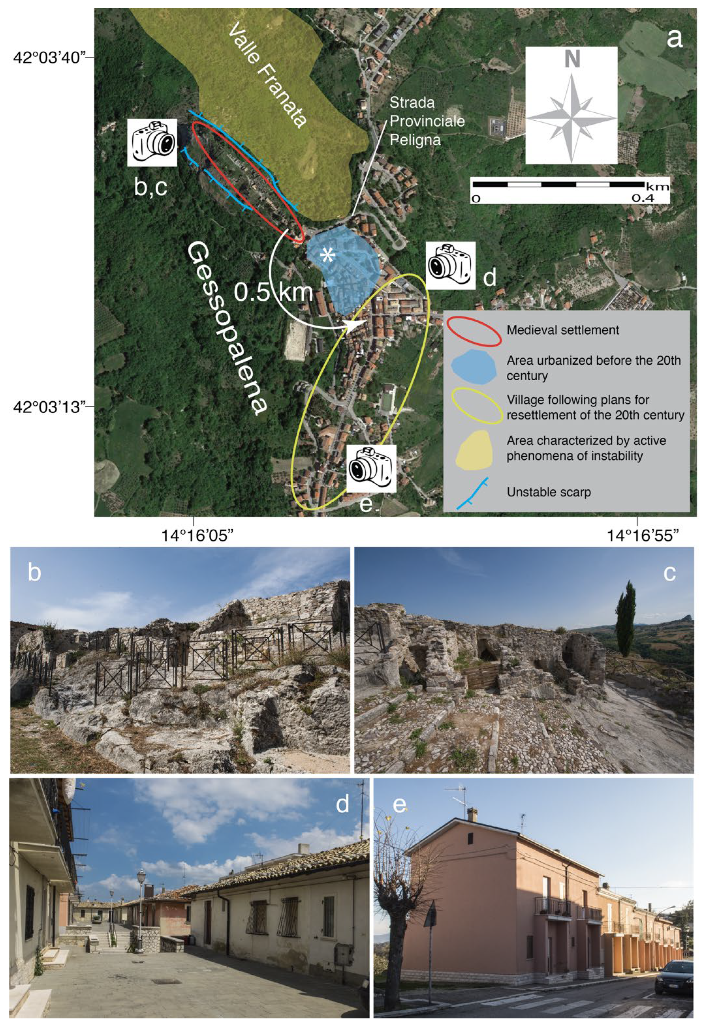
The hill of the medieval settlement of Gessopalena (red ellipse in Figure 11a–c) at 650 m a.s.l. in the Aventino Valley, south of the Maiella massif, is made of microcrystalline gypsum, a peculiarity among the Apennine rocky villages. Colonization valleyward of the original settlement began in the 18th century with the first residential complex from which the village progressively developed during the 20th century to reach the present layout. A topographic map from 1910 shows a built-up area symmetrically distributed across the local main road (Strada Provinciale Peligna), with the old village NW of it and the more recent buildings to the SE (Figure 11a). In this latter sector the density of the buildings was much lower than the present one and, for this reason, a prevalence of one sector with respect to the other was not defined at the beginning of the 20th century. On the whole, Gessopalena was populated by about 3400 inhabitants before 1933, while current residents are about 1550.
While the hill of the original village is made of gypsum rock, which represented a rigid substratum suitable for building foundation in the Middle Ages, the adjacent valleys and flat areas are carved into highly erodible Pliocene clays of the so-called “Aventino-Sangro Gravity Flow” [70,71]. The already mentioned Inventory of Landslides IFFI indicates that the relief of the original settlement is characterized by active processes, such as rockfalls and toppling of great gypsum blocks, particularly in the southern and northern sectors. This is consistent with information reported on the map of landslide hazard, indicating instability along the scarps of the hill [72]. The IFFI inventory also reports dormant sliding with evidence of complex movements for the entire NW-SE trending valley that is north of the old village. A high level of hazard is associated with these gravitational motions, considered to be presently active or with seasonal activation, depending on climatic conditions [72]. Due to this geological aspect, the valley north of Gessopalena had the non-reassuring place-name of “Valle Franata” (Figure 11a), i.e., slid-down valley, in documents from the 19th century. Erosion and landslides in its southern flank caused the instability of the hill in the past centuries and damage to the buildings of the original settlement.

3.5.2. Abandonment and Resettlement of Gessopalena

Available historical documents indicate the coexistence of the village and landslides since the end of the 18th century (A. Manzi, personal communication) with increasing manifestations of the instability from the beginning of the 19th century. In this period, the village is described as founded on a huge boulder and partly in the flat area where it will develop during the 20th century, and affected by a landslide with the potential to cause the ruination of the territory [73]. At that time, the origin of the instability was attributed to intense deforestation that had continued since the end of the 18th century [74], activity which evidently caused problems to many slopes of the Abruzzi Apennines and which was also indicated for the previously discussed case of Salle. In 1812, the landslide had already destroyed buildings in the valley and was undermining the stability of the hill and threatening more buildings at the margin of the village and the main local road. At that time, institutions planned a drainage system to optimize the water regime in the valley, but no works were conducted until 1843, when dykes of dry-stone walls were built together with channels excavated in the unaltered soil to avoid water runoff and erosion. Plans to reforest the valley were also newly proposed, following hypotheses of 30 years earlier.
In the first half of the 20th century, the effects of the 1915 and 1933 earthquakes and the significant consequences of the Second World War added to those of the slope instability. The 1915 earthquake was responsible for damages estimated as Intensity 7 MCS [26]. Although this value indicates a non-negligible shaking, documents do not describe a reappraisal of the landslide processes. The reactivation occurred during the 1920s, particularly after the winter of 1928–1929, due to intense snowfall and persistence of the snow cover in Valle Franata. Gravitational motions deformed and displaced the ancient dykes, again threatening the main road, the rocky hill (where ground cracks were observed), and the related buildings, which were some houses SE of the hill. In February 1933, the works conducted in the valley during the 19th century were defined as almost entirely disappeared and the area was considered to be potentially subject to vast landslide motions.
On the whole, the great worry for the destiny of the historical settlement and the works conducted during the 19th century indicate the firm intention to preserve the village against natural events. Consulted documents from the 19th century and the beginning of the 20th never mention a possible resettlement elsewhere.
This perspective drastically changed with the 1933 earthquake, when the village was heavily damaged (Intensity 8 MCS in [26]). The synthetic description of the earthquake effects sent by the Prefectural Commissioner of Gessopalena to Ufficio Centrale di Meteorologia e Geodinamica mentioned violent shaking responsible for damage to some 100 houses (inhabited by approx. 450 people) that were subsequently considered unfit for use. On 23 December 1933, the Civil Engineering Office reported 117 unrepairable buildings, 49 seriously damaged, and 273 slightly damaged; the picture got worse in February 1934, with 160 unrepairable buildings, 65 of which were still inhabited.
The earthquake represented the opportunity to begin the process of resettlement. Reconstruction was prohibited in the old center on the basis of the Decree-Law 16 October 1933 no. 1334, and a decree of 6 November 1933 by the Ministry of Public Works that included Gessopalena in the already mentioned Table E of 1908 reporting the built-up areas for which relocation was considered necessary.
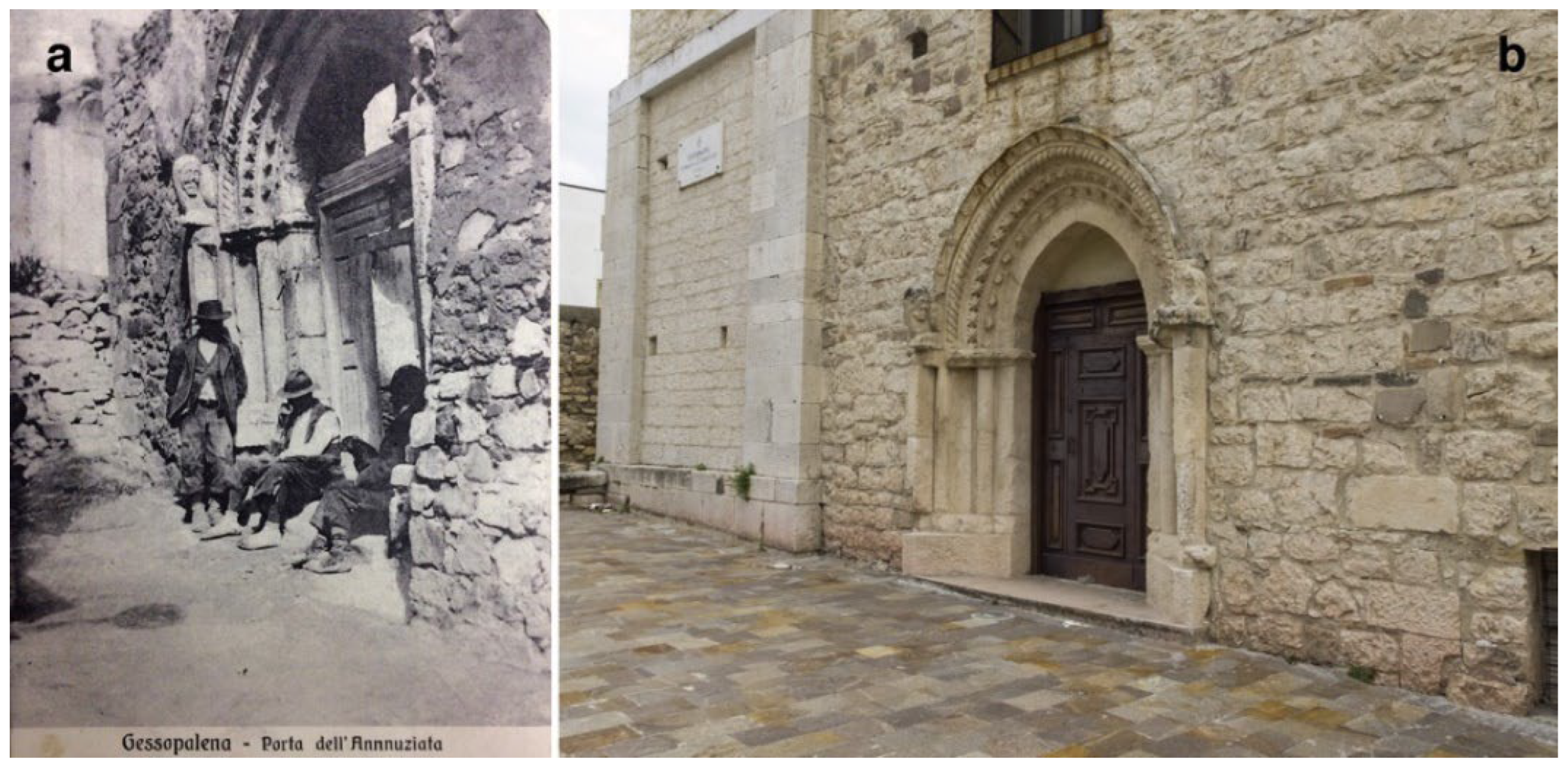
Apart from the regulatory framework, improvement of the living conditions represented the main reason for the residents to immediately accept relocation to the new settlement at about 0.5 km from the original one. A geological description of the gypsum hill, drawn a few days after the earthquake (report available at the State Archive of Chieti), most dramatically depicted the place where people had lived for centuries (“gypsum mass obscurely stratified”, “green and red sliding clays”, “ground cracks preceding the earthquake”, “water descending in the subsoil and solving the gypsum”, and “fracture with a displacement of 30 cm”). This contributed to endorsing the hypothesis of the resettlement, since the same geologist concluded that the geological framework did not permit rebuilding in the same place. Paradoxically, the instability of the adjacent valley, the real problem threatening Gessopalena, was not mentioned by the geologist as a valid reason for the resettlement. This suggests that the geological report was drawn without a complete survey, probably with the aim to rapidly support the relocation.
A sector of the flat terrace located about 0.5 km SE of the gypsum hill was chosen at the beginning of 1934 for the reconstruction (northernmost portion of yellow ellipse in Figure 11a,d). If the geological features of the old village were dramatically depicted, those of the new location were reassuring, though only defined with general terms (“very firm soil” and “free from landslides”) in a document by a local political organization (now at the State Archive of Chieti). Actually, geological aspects were not overriding and only had a formal role in the whole procedure, as indicated by the fact that the accumulation of reworked materials necessary to arrange the area for reconstruction caused small landslides, differential settlements, and consequent cracks and damage to the new buildings, as indicated by a report of the Civil Engineering Office dated 1940.
New episodes of instability affected the gypsum hill in 1940, representing a reason for further delocalization of residents. The ancient village suffered additional significant damage due to the explosion of mines during the Second World War, on 4 and 5 December 1943.
After the 1933 earthquake the century-old history of the rock settlement rapidly came to an end, more due to the political interest for the abandonment than for geological reasons, considering the discomfort of the built-up area, the archaic layout of the residential buildings, and the economic advantages of proximity to the main regional road. For this reason, the geological evaluations had a different role throughout the 19th and 20th centuries. Earlier, data collected on ongoing instability phenomena were used by contemporary engineers to plan works to reduce landslide risks. After the 1933 earthquake, geological surveys no longer provided data to mitigate landslide effects, but only supported previously defined political strategies.
A new reconstruction plan was drawn up in 1954, completing the resettlement with buildings in the southern sector of the village (southernmost portion of yellow ellipse in Figure 11a,e).

3.5.3. Gessopalena Today

Within the framework of abandonment and destruction, the reconstruction plans drawn by the Ministry of the Public Works in 1954 gave the coup de grace to the ancient built-up area, since prospects of recovery were completely lacking: “it represents the part of the village that will not be rebuilt and which, therefore, will be abandoned”. This choice was again supported by geological inferences, since the local soil was defined as “prone to drag the entire hill towards ‘Valle Franata’”. However, the remains of the original village did not suffer dragging in the adjacent valley during the following decades and they are presently preserved in an archaeological area (Figure 11b,c), although evidence of instability can be detected on the hill (Figure 12). The remaining walls have been consolidated and panels give the necessary historical information and define the use of the various buildings. Visitors can walk along the main road of the old village, looking at the outer walls of buildings made of calcareous, arenaceous, and gypsum stones, up to the remains of the church dedicated so long ago to Sant’Egidio [43].
Concerning the 20th century village, the first residential complex built after the 1933 earthquake, between the church of Santa Maria dei Raccomandati and via Gennaro Finamore, still shows the original, regular, and neat layout that is typical of the planned reconstruction, assuming a role of material evidence of the local history (Figure 11d). Moreover, the expansion of the settlement, which, following the plan of 1954, completed the relocation of the original village, is testified by the buildings in the southernmost sector of the modern town, along the Monte Calvario road (Figure 11e).
A valuable symbol of this history of abandonment and resettlement is represented by the beautiful medieval (14th century) portal of the church of Santissima Annunziata, formerly in the original village and subsequently inserted in the left flank of the church of Santa Maria Maggiore, in the present town center (Figure 13) [75].

4. Discussion

4.1. The Role of Geological Knowledge in the Abandonment and Resettlement of Villages

The histories of the five investigated cases are summarized in Figure 14. The proposed scheme indicates that no relationship between technical decisions and government political power can be defined. The episodes of the long history of abandonment and rebuilding crosses the Italian pre-fascist monarchic state, the fascist period, and the post-war democratic republican state. This suggests that differing forms of government, political ideals, and state organizations had no influence on the general views and the theoretical approach to the development and modernization of built-up areas.
Another point emerging from Figure 14 is that all the described histories have apparently been conditioned by adverse geological conditions. These aspects may be of interest for present assessments concerning urban and engineering geology, since possible plans of regeneration have to consider local natural hazards. However, historical approaches are not very useful within this perspective. The actual characteristics of the described hazards and the potential risks in the cases of Frattura, Sperone, and Albe only derive from recent or present knowledge that were unavailable at the time of the technical decisions about resettlement. In contrast, the threat due to landslides in the cases of Salle and Gessopalena was already clear in the 19th century and scientific and technical expertise at the beginning of the 20th century was probably enough to promote interventions of risk mitigation. However, for different reasons, few interventions were made by the Ministry of Public Works and the 1933 earthquake was, in both cases, the hint to relocate the inhabitants, providing the opportunity to the technical offices to take shortcuts with respect to the mitigation of the natural risk.
More in detail, the historical documents define the limits of the geological culture in approaching natural hazards during the first half of the 20th century, when resettlements were decided. Knowledge of the geological settings was incomplete; indeed, fault investigation was taking its first steps, investigations on deep-seated gravitational movements only took hold decades later, the recognition of peculiar stratigraphic superpositions for the evaluation of site effects was far from being a key aspect in land-use planning. As a result, (i) the presumed foundation on landslide debris was considered the main cause for the high level of damage at Frattura and a sufficient reason for resettlement which, paradoxically, occurred in an area close to a slope affected by deep-seated gravitational deformations; (ii) the foundation on a steep slope and the presence of slope debris and clay soil was considered to be the adverse geological condition of Sperone, instead of its closeness to fault emergence and deep-seated gravitational deformations; (iii) site effects being unknown, the rebuilding of Albe was proposed in the same place as the ancient village, located on a carbonate hill structurally related to the thrusting of those rocks on arenaceous-clayey flysch, and resettlement elsewhere was only motivated by survivors’ emotional decisions; (iv) the landslide of a stream bank was rightly considered to be a potential cause of destruction for Salle, but the planned technical solutions useful to mitigate risk were never fully adopted and the drastic decision of resettlement, approved and imposed since 1908, triggered relocation only after the 1933 earthquake and within the framework of the reconstruction of an entire damaged region; and (v) slope instability was presumed to be a main problem for the hill where Gessopalena was founded, although gravitational displacements created minor problems to the remains of the village during the 20th century and similar settlements elsewhere in Italy benefited from interventions preventing damage. However, similarly to Salle, the critical geological setting and the effects of the 1933 earthquake were used to plan the relocation of the village.
These are the geological and technical frameworks within which resettlement of the medieval villages occurred. The five histories of rebuilding suggest that interpretation of the natural hazards with the culture of the time accompanied and supported the political and social visions pointing to the modernization of the settlement model. In some cases, historical documents feed the feeling that geology and geological hazards had an instrumental role in supporting the political action. On the whole, the remains of the abandoned villages not only testify to the century-old settlement histories, but also represent material evidence of the relationship between science and politics.

4.2. Landscape

Apart from the evaluations on the role of geology in the definition of the settlement model, the five cases illustrate the historical complexity of the processes that led to the abandonment and resettlement of villages. These processes contributed to forming the current landscapes, as indicated by the material evidence of the abandoned and resettled built-up areas. This means that the local landscapes, including the traces of the abandonment and resettlement processes, may represent valid information sources and tools to help understand and learn the complex natural or human history that modelled the various Apennine territories discussed here (Figure 15).
This potential perspective is rooted in the very concept of landscape, as expressed in the European Landscape Convention (ELC): “area, as perceived by people, whose character is the result of the action and interaction of natural and/or human factors” [76] (art. 1). This view, which may be summarized in intending landscape as a relationship between culture and nature, implicitly includes the historical dimension, since the interaction mentioned above has served to model the territories over centuries or millennia [77] (pp. 234–258, on “landscape temporality”). Moreover, the same definition draws attention to protecting the traces of past events, since they are part of the cultural heritage that has a key role in the identity of societies.
Once the ELC definition and the above-mentioned consequences have been accepted, the next step toward the educational perspective is brief, and we can easily understand why an educational role has been traditionally attributed to landscape and natural environments; for example, see [78,79,80,81,82].
If a landscape results from “the action and interaction of natural and/or human factors”, then understanding those factors implies interpretation of the related evidence. For this reason, landscapes have been considered in terms of their interpretation or representation manifested in texts, figurative arts, photography, etc., until the metaphor of landscape as text took hold in the 1980s [83] (“reading a landscape as we might read a book” is a concept expressed by Lewis [84], and by the Italian writer Giorgio Manganelli in 1965 [85] (p. 23)).
As for the territories characterized by seismic nature, as those described in the previous sections, landscape features can be “read” by geologists, geographers, archaeologists, historians, architects, engineers, etc. In doing so, experts adopt a semiotic approach to the interpretation, by identifying signs (“independent identifiable meaningful units”, see [86]) that define the character of a territory. Experts may in turn transmit their experience of landscape interpretation to people living in the seismic territories, acting as educators, both illustrating seismic traces de visu (e.g., during field excursions, conferences with slide projections, etc.) and promoting knowledge by contributing to permanent in situ information. Overall, by transmitting the meaning of specific landscape features, expert educators should try to introduce those features in the sphere of the collective memory, acting in the wider field of the improvement of local environmental culture.

4.3. Ecomuseums

The educational perspective may be facilitated by arranging the selected areas to empower the messages sent out by landscape features. This has been defined as an “edited environment” by Szczepanski [87], looking to botanical gardens, zoos, natural museums, etc., and a possible solution to preserve or promote the abandoned places and show the consequences in terms of resettlement (i.e., a way to represent “signs” of a seismic nature) is offered by open-air museums and especially by ecomuseums (Figure 15), since they permit protection of the remains in the original place and give a persistent memory of places and their history (e.g., [88,89,90,91]; see [92,93] for Italian cases of ecomuseums involving geology). By linking landscape, sites, territories, memories, nature, heritage, and communities with the scope to preserve the relationship among the mentioned interlaced categories, these museums could represent educational tools for residents in seismic territories, to increase awareness of risk by narrating site histories. Moreover, ecomuseums may offer chances in the perspective of cultural tourism (for example, see [94,95]) or geotourism to propose the fruition of sites affected by natural disasters (e.g., see [20]) for regions needing original proposals to attract visitors (Figure 15). Addressing the tourism perspective is far beyond the scope of this article. However, three aspects should be considered: (i) the selected localities are halfway between Rome and cities on the Adriatic coast (Pescara and Chieti); (ii) the investigated territories are generally frequented by trekkers and hikers; and (iii) the Apennine region is characterized by a significant “return tourism”, practiced by owners of dwellings inherited from distant relatives. Point (i) defines a large potential catchment area; point (ii) suggests that open-air museums may give peculiar tourism opportunities to people looking for the combination of cultural and physical activities. Instead, point (iii) introduces more practical aspects. Most historical buildings, temporarily frequented by owners living elsewhere, did not benefit from the structural interventions necessary to reduce vulnerability. A consequence is the deficit of seismic safety. A cultural proposal concerning the effects of past natural catastrophes in nearby territories may stimulate interventions on ancient buildings and promote seismically safe tourism-related stays.
The ecomuseum perspective and, more generally, that of open-air museums, expands the use of geoheritage sites [96] or geomorphosites [97] (such as the Serrone fault mentioned in Section 3.2.3 [56]), by including the geological evidence into the historical and social perspective. This means that geosites, generally dedicated to significant geological aspects, may become sections of a wider museum arrangement. The use of geology in the historical perspective can be observed at important archaeological sites showing remains of ancient cities destroyed by natural catastrophes (e.g., Pompeii, Santorini, etc., which have an educational potential on natural hazards not heretofore fully exploited [20]). As for the abandoned villages of the Contemporary Age, the educational perspective derived from the combination of geology and history was suggested both in general terms [96] and for a specific case (that of Craco, in Southern Italy) [19].
On the whole, ecomuseums are considered “tools for the cultural mediation, the education to the participation, the enhancement of the knowledge, the protection of collective interests, the sustainable use of the land, the creation of landscapes, the planning of the territory, as well as the promotion of responsible tourism” [98]. In the areas described in this paper and in similar cases, ruins and remains may act as common threads to represent historical events, with fruition models similar to those of the archaeological areas, but with further attention paid to the geological frameworks within which the settlements evolved, and to the modern villages completing the picture of the historical parable. The didactic perspective can be developed by means of educational trails linking material traces of the past catastrophes, as suggested by Migoń and Pijet-Migoń [20], who mentioned cases in New Zealand and South Dakota, USA related to the effects of volcanic activity and flooding, respectively. Trails could end with a visit to an indoor museum (or exhibition) dedicated to the history of the territory and the related evolution of the landscape, conditioned by the past natural catastrophe, i.e., a type of educational proposal which has been adopted worldwide in sites struck by extreme geological events [20,97,99,100].
Although the Abruzzi region is characterized by numerous and, often, complex cases of the abandonment and resettlement of villages, few are available in the perspective discussed above. Cases of preservation or promotion result from partial views, generally not linking remains of settlements to the geological events that conditioned resettlements, and to the built-up areas of the 20th century. For example, in the discussed case of Gessopalena, the remains of the old village are presented in a way similar to that of an archaeological area. This perspective, which has the respectable function to preserve the remains together with that of their cultural usability, does not introduce visitors to the geological dimension that had a key role in the story of the village. Moreover, a guided trail linking the remains to the original core of the resettled village (i.e., providing a complete picture of the historical parable) is missing. On the other side, a geological feature such as the Serrone fault (Section 3.2.3) benefited from interventions in the popular perspective [56]. However, in this case, proper sensitivity to the consequence of the fault activation, i.e., the remains of the old and intermediate villages of Sperone, is lacking. This deficit of information is comparable to that defined for other cases around the world by Migoń and Pijet-Migoń [20].
On the whole, these attempts to render ruins and geomorphic evidence usable to people fail in the perspective of interlacing communities and settlement histories with the natural characteristics of the sites. Therefore, the proposed messages appear as partial, since the educational potential is not fully exploited. In contrast, a thorough representation of the landscape, i.e., by linking natural and anthropic dimensions, is more realistic from the historical point of view, since the settling history is rooted in the geological sphere. Moreover, being more varied, the proposal could be more interesting and more effective.
Based on this discussion, an ongoing project regarding Albe, sponsored by the local municipality, arouses great interest. Indeed, the title itself “Connecting fragments of history” (transl. from Italian “Connettere frammenti di storia”) points to a view wider than that of the conservation or promotion of the abandoned village. The ruins of the ghost village are part of an educational route linking different traces of the complex and lengthy local settling history, including the town of the Roman Age and the natural paroxysms that struck the territory. Works are currently underway at Albe to restore the road network of the ancient village and to strengthen some ruins in the church area. These activities will be followed by the preparation of information panels.
Significant interest for these issues can be noticed in Salle, where information panels have been recently (June 2022) distributed between the ancient and new village. As usual, the goal is to represent the local history related to both the life of the medieval settlement and the foundation and construction of new Salle. In this case, the element of innovation is represented by the connection of the two villages, which is lacking elsewhere. Moreover, maps are presented in reporting sites where material evidence of this history can be detected. This admirable approach would certainly benefit from similarly arranged geological information on the complex natural events that conditioned the local history, and by setting up routes to detect the 1906 landslide scarp and accumulation, the sediments composing the terrace of ancient Salle, and the evidence of the erosional activity of Rio Maggio and the hydrogeological threat, etc.

4.4. Outdoor Education

The ecomuseum perspective may include various options (e.g., field excursions, conducted tours, field activities, and open-air laboratories) in the wide spectrum of outdoor education and the related outdoor learning and place-based education (Figure 15); for example, see [78,80,81,101,102,103,104,105,106].
The more advanced place-based practice has been defined as “place essential” and is related to learning in the exact places where facts occur or evidence can be collected [105,107]. The place-based and place-responsive approaches generally benefit from educators’ activity [81,105]. Field excursions, for example, are included in “outdoor education”, appearing as valuable tools, especially when emphasis is used for place-specific elements [108]. For this reason, views of active fault scarps (such as that of the Serrone relief mentioned in this paper) or of ghost villages abandoned after seismic events (such as the original settlement of Sperone located close to the Serrone fault) may become memorable experiences. The effectiveness of the approach is definitely higher when the educational initiatives involve people living in the territory manifesting the landscape features used as educational tools. This may be a consequence of attitudes of the so-called “communities of place”, since people developing place attachment may be more interested in understanding how the local landscape or environment relates to their lives and residents may be inclined to know about place history and motivated to improve one’s community [109,110,111,112,113,114,115,116]. Moreover, knowledge of places by inhabitants may represent the tool for connecting to everyday life, which is considered to be a component of pedagogic approaches to “outdoor education” [80].

4.5. Reduction of Seismic Risk

The aim of proposals such as ecomuseums and outdoor education is based on the growth of awareness of seismic hazards necessary for more effective risk reduction (Figure 15).
Recent studies indicate that seismic risk in Italy is underestimated; for example, see [117,118]. For example, in the territories characterized by the highest hazard (zones 1 and 2 of the Seismic Hazard Map of Italy, including the Apennine areas presented in this paper [119], 86% (zone 1) and 70% (zone 2) of people underestimate the potential consequences of an earthquake [118]. This is one of the reasons for reduced actions in favor of risk mitigation, notwithstanding the significant seismic history of the Italian territory, which, evidently, is poorly known to those living in zones 1 and 2.
The educational perspective outlined above may help to better comprehend the local seismic histories, to introduce them to the collective memories, and to improve the local risk perception (Figure 15). Therefore, the educational approach may contribute to increasing the interest of residents for interventions aimed at reducing the seismic vulnerability of their houses, which in many Apennine villages can be included in the wide category of the historical buildings far from the modern criteria of seismic safety.
If seismic safety is the main goal, these activities may in turn be included within the wide spectrum of actions pointing to environmental sustainability in the development of territories (Figure 15). The truthfulness of this statement is proven by the impact that the strong Apennine earthquakes also had on the ancient villages in recent times. The seismic events of 2009 and 2016–2017 in central Italy (three earthquakes with M ≥ 6 and nine earthquakes with M > 5, respectively) caused hundreds of casualties and ruined numerous historical settlements, forcing people to relocate to temporary residences for years, sometimes in other regions, accelerating the natural depopulation of areas already characterized by demographic contraction. Moreover, post-earthquake renewal of ruined villages, should it happen, needs enormous public investment, through long-standing practices, and is characterized by uncertain results, both for the perspective of repopulation and for the new layouts deriving from the choices adopted in the reconstruction plans.

5. Conclusions

The cases of the abandonment and resettlement of villages discussed in the previous sections may be considered to be peculiar examples of the complex evolution of the Italian living style during the 20th century and the related impressive changes of the landscape following centuries of minor modifications since the Medieval Age.
Social needs and political visions were probably prevailing factors. Often (and certainly in most of the studied cases), the adverse geological conditions and their interpretation of a century ago played an instrumental role in triggering the practices of resettlement by supporting choices based on the visions of the civilization of society and the modernization of settlements. The hypothesis is fostered by the superficiality and the hurry of some interpretations regarding local natural hazards and by the insufficient actions to reduce the risk related to slope instability even considering the scientific knowledge and technical expertise of that time.
Apart from the consistency of the geological issues and their weight in determining resettlements, the main current problem is represented by the preservation and potential use of the abandoned villages. Local administrators and residents may decide to leave the remains in their state derived from decades of a lack of maintenance, as actually occurs in most cases. Isolated walls and more or less significant portions of buildings may be (and are being) colonized by vegetation, contributing to the so-called “third landscape” discussed by Clément [62]. In such cases, sporadic exhumations of the remains (e.g., on the occasion of anniversaries of the catastrophes), such as cutting trees and shrubs enveloping the villages, do not seem to be appropriate actions since they expose unconsolidated masonry walls to the exogenous elements and consequent decay. The inclusion of the remains in archaeological areas permits their preservation and fruition for the benefit of those who like to learn aspects of the local history of one or two centuries ago. However, this perspective, while especially respectable for the conservation of the remains, also gives partial visions of the complex historical frameworks. The experience matured during this study, in a region with natural hazards significantly conditioning local histories, suggests that the educational perspective should be wider than that limited to the archaeological fruition. For this reason, the perspective of ecomuseums connecting the material traces of the histories should be promoted. The geological and geomorphological evidence of the natural catastrophes, the consolidated remains of the abandoned villages and the built-up areas following resettlement can be connected in order to give complete pictures of the past events. Fruition of the material evidence of the local histories can have an impact on the awareness of natural hazards and produce benefits in the perspective of risk mitigation.

Funding

This research has been partially financed by the Istituto nazionale di geofisica e vulcanologia (Rome, Italy), project Legge Regionale Abruzzo no. 37/2016.

Data Availability Statement

Results reported in this study are based on the analyses of historical documents available in public Italian State Archives, as indicated in detail in Appendix A, and on geological field investigations performed by the author.

Acknowledgments

The author is grateful to F.M. Botticchio, E. Ceccaroni, A. Manzi, A.M. Socciarelli, A. Tertulliani for the useful discussions, the support and the willingness to provide information and materials on the various aspects discussed in this article, during the ten-year-long research. The author is also grateful to two unknown reviewers for the very useful comments and suggestions.

Conflicts of Interest

The author declares no conflict of interest.

Appendix A

A summary of the historical documents consulted to reconstruct the abandonment and resettlement histories of Frattura, Sperone, Albe, Salle, and Gessopalena, completing the information produced in Section 3, is listed here.

Appendix A.1. Frattura

At the time of the 1915 earthquake, Frattura was included (and still is) in the municipality of Scanno. Historical sources (1915–1952) are mainly represented by correspondence between local authorities (prefect of L’Aquila, mayor of Scanno) and various members of technical institutions, especially from the Ministry of Public Works and the Civil Engineering Office at L’Aquila, who also produced technical reports, particularly in the period between 1917 and 1943. Documents are available in the State Archive of L’Aquila, collection “Prefettura, Series II, Affari dei Comuni”: (i) “VII versamento, folder 533, Scanno 1909–1917”; (ii) “IX versamento, folder 813, Scanno 1930–1931”; (iii) “IX versamento, folder 814, Scanno 1932–1933”; (iv) “IX versamento, folder 815, Scanno 1934”; (v) “IX versamento, folder 817, Scanno 1935–1941”; (vi) “IX versamento, folder 818, Scanno 1935–1941”; (vii) “IX versamento, folder 820, Scanno 1935–1941”; (viii) “IX versamento, folder 823, Scanno 1942–1952”. Fundamental information that has been derived from the Archive of the Civil Engineering Office at L’Aquila is available in the State Archive of L’Aquila, though pending reorganization, and is presently contained in original folders defined as “Titolo III, Classe A, Fascicolo 13”, “Servizio Terremoto, Atti di repertorio, dal n. 746 al n. 806” and “Servizio Terremoto, Atti di Repertorio, dal n. 1165 al n. 1470”. Further information related to the local churches was collected from the Archive of the Sulmona and Valva Diocese (“Sante visite. Visite vicariali 1937–1957”, folder 8) at Sulmona.

Appendix A.2. Sperone

At the time of the 1915 earthquake, Sperone was included (and still is) in the municipality of Gioia dei Marsi. Information has been derived from consulting documents (correspondence mainly involving the Civil Engineering Office of Avezzano, the mayor of Gioia dei Marsi, the Prefect of L’Aquila, and technical reports of the Civil Engineers) related to the period from 1917–1964. Most documents were extracted from the Historical Archive of the Regional Civil Engineering Office at Avezzano, in particular from: (i) “Opere di risanamento abitati (legge 9/8/1954, n. 640), folder 2873A Z7/5, Gioia dei Marsi”; (ii) “Opere di risanamento abitati/Eliminazione case malsane (legge 9/8/1954, n. 640), folder 2883a, file ‘Demolizione baracche in Sperone’”; (iii) “Opere dipendenti dal terremoto del 1915; edilizia scolastica; costruzione edificio scolastico nella frazione Sperone di Gioia dei Marsi, folder 1008a/60/2”, which greatly contributed to reconstructing the history of Sperone during the 20th century. Information was also derived from the State Archive of L’Aquila, from (i) the collection “Prefettura”, “Atti relativi al terremoto della Marsica (13 gennaio 1915), folder 10, Gioia dei Marsi (1915–1924)” and (ii) the collection of the Office of the Civil Engineers, awaiting reorganization, reported in an original folder titled “Servizio Terremoto, Atti di Repertorio, dal n. 746 al n. 806”. Moreover, documents of the Central State Archive at Rome gave information on the first resettlement of Sperone: collection “Ministero dell’Interno, Direzione Generale dell’Amministrazione Civile, Ufficio Servizi Speciali, Terremoto della Marsica del 13 gennaio 1915”, folder 145 (by courtesy of F.M. Botticchio). Finally, the Collection “C”, folder 95, of the Archive of the Marsica Diocese (Avezzano) was consulted.

Appendix A.3. Albe

In 1915 Albe was included (and still is) in the municipality of Massa d’Albe. Documents on the history of Albe between 1915 and the 1940s were mainly consulted in the Central State Archive, at Rome, and secondarily in the State Archive of L’Aquila and in the Archive of the Marsica Diocese at Avezzano. As for the Central State Archive, sources are related to correspondence involving the Ministry of the State Education and the Superintendence having the duty to recover the precious and famous masterpieces of religious art from the ruins of the church of San Nicola. In particular, the investigated collection is that related to “Direzione Generale delle Antichità e Belle Arti”, (i) “Divisione I, folder 805, 1908–1924”; (ii) “Divisione I, folder 269, 1913–1915”; “Divisione II, folder 238, 1934–1940”.
The collection of “Prefettura” was consulted at the State Archive of L’Aquila, in particular, (i) “Atti terremoto 1915, folder 35, files 236 and 247” and (ii) “Atti terremoto 1915, folder 10”. Historical materials of the Civil Engineering Office, awaiting reorganization, can be consulted in the same archive, originally defined as “Atti di repertorio, Servizio Terremoto dal n. 955 al n. 1164”.
Documents on the damage suffered by Albe in 1915 were found in the Archive of the Civil Protection at Rome, awaiting reorganization of the presently uncatalogued materials. In particular, information is included in a folder originally defined with no. 9 and the caption on the spine “Div. 15” (by courtesy of F.M. Botticchio who had the opportunity to visit the archive).
The list of the precious religious artworks buried in the ruins of the church of San Nicola can be consulted in the Archive of the Marsica Diocese, Collection “C”, folder 95.

Appendix A.4. Salle

Documents necessary to reconstruct the history of Salle in the period from 1907–1958 can be consulted in the State Archive of Pescara, in the collection “Genio Civile”, including correspondence between the local Civil Engineering Office and various institutions (Municipality, Prefecture, Ministry of Public Works, Diocese, etc.), available as: (i) “Serie Comuni, folder 28, files 411-444, 1907–1957”; (ii) “Serie Comuni, folder 26, files 392–403, 1909–1939”; (iii) “Serie Comuni, folder 27, files 404–410, 1929–1955”; (iv) “Serie Comuni, folder 25, files 380–391, 1935–1956”; (v) “Serie Comuni, folder 4, file 79, 1936–1940, Comune di Salle: Opere pubbliche. Opere dipendenti dal terremoto del 26-9-33”; (vi) “Serie Comuni, folder 5, file 106, 1937, Comune di Salle: Costruzione della Casa Comunale—Relazione”; (vii) “Serie Comuni, folder 48, file 877, 1953–1958”; (viii) “Serie Comuni, folder 3, file 60, Comune di Salle: spostamento dell’abitato e sistemazione montana del Rio Maggio”. Further information has been derived from the State Archive of Chieti, collection “Terremoto, pratiche generali”, folder 3, and from the Central State Archive at Rome, collection “Terremoto Marsica 1915”, folder 199, file 3.

Appendix A.5. Gessopalena

The history of Gessopalena from the beginning of the 19th century (1809) to the second postwar period of the 20th century (until 1962) has been reconstructed on the basis of historical documents available in the State Archive of Chieti. The consulted documents relate to various collections including correspondence and reports related to the landslide and mainly involving the Municipality, the Prefecture, and the various technical offices that, for approx. 150 years, went into planning land use and works necessary for the defense against natural catastrophes: (i) “Intendenza, Affari Comunali, folder 519, Gessopalena, 1807–1815”; (ii) “Intendenza, Affari Comunali, folder 518, Gessopalena, 1807–1867”; (iii) “Intendenza, Affari Comunali, folder 507, Gessopalena, 1822–1827”; (iv) “Intendenza, Affari Comunali, folder 509, Gessopalena, 1833–1836”; (v) “Intendenza, Affari Comunali, folder 511, Gessopalena, 1842–1845”; (vi) “Intendenza, Affari Comunali, folder 513, Gessopalena, 1846–1849”; (vii) “Intendenza, Affari Comunali, folder 512, Gessopalena, 1843–1877”; (viii) “Intendenza, Affari Comunali, folder 514, Gessopalena, 1850–1859”; (ix) “Intendenza, Affari Comunali, folder 516, Gessopalena, 1856–1859”. Information on the 20th century history has been derived from documents available in the State Archive of Chieti, the Central State Archive at Rome, the Archive of Soprintendenza Archeologia, Belle Arti e Paesaggio per le Province di L’Aquila e Teramo at L’Aquila, and at the Ministry of Infrastructure and Transport. As for the former, consulted documents are included in the collections: (i) “Prefettura”, “Affari Comunali, V versamento, Gessopalena, folder 210, file Gessopalena, frana 1936–1940”, “Affari Comunali, V versamento, folder 211, Gessopalena 1907–1969”, “Affari Comunali, V versamento, folder 212, Gessopalena 1908–1965” and “Affari Comunali, V versamento, folder 213, Gessopalena 1921–1968”; (ii) “Genio Civile”, “Terremoto, folder 3”, “Terremoto, folder 4” and “Terremoto, folder 5”; (iii) “Ufficio del Genio Civile”, “Opere a totale carico dello Stato, Edilizia economica e popolare, folder 3”.
Documents of the Central State Archive at Rome are related to the collection of the Ministry of the State Education: (i) “Direzione Generale Antichità e Belle Arti, Divisione I, 1913/1915, folder 435, file 983”; (ii) “Direzione Generale delle Antichità e Belle Arti, Divisione II, 1934/1940, folder 144”.
As for the Archive of Soprintendenza Archeologia, Belle Arti e Paesaggio per le Province di L’Aquila e Teramo at L’Aquila, a file numbered 358 and dedicated to “Gessopalena, Chiesa di S. Maria Maggiore” has been consulted.
Finally, conspicuous information on the reconstruction plan of Gessopalena during the second post-war period is gathered at the Ministry of Infrastructure and Transport, Archive of Direzione generale per lo sviluppo del territorio, la programmazione e i progetti internazionali, at Rome.

References

  1. Brown, L.R. Ghost Towns of the Colorado Rockies; Coxton Press: Caldwell, ID, USA, 1968; 402p. [Google Scholar]
  2. McNab, C. Ghost Towns; Amber Books: London, UK, 2016; 224p. [Google Scholar]
  3. East, M. Community-led approaches and interventions for the regeneration of abandoned towns in southern Italy. Ecocycles 2016, 2, 18–25. [Google Scholar] [CrossRef] [Green Version]
  4. East, M. Integrated approaches and interventions for the regeneration of abandoned towns in southern Italy. In From Conflict to Inclusion in Housing: Interaction of Communities, Residents and Activists; Cairns, G., Artopoulos, G., Day, K., Eds.; UCL Press: London, UK, 2017; pp. 87–102. [Google Scholar]
  5. Wickham, C. Castelli e incastellamento nell’Italia centrale: La problematica storica. In Civiltà Medioevale Negli Abruzzi; Boesch Gajano, S., Berardi, M.R., Eds.; Edizioni Libreria Colacchi: L’Aquila, Italy, 1990; Volume 1, pp. 110–123. [Google Scholar]
  6. Clementi, A. L’incastellamento negli Abruzzi: Problematica ed Esempi; Andromeda Editrice: Colledara, Italy, 1996; 79p. [Google Scholar]
  7. Redi, F. L’incastellamento nel territorio aquilano: Primi dati per una ricerca archeologica. Archeol. Mediev. 1997, 24, 427–438. [Google Scholar]
  8. Somma, M.C. Siti Fortificati e Territorio: Castra, Castella e Turres Nella Regione Marsicana Tra X e XII Secolo, 1st ed.; Fratelli Palombi Editori: Roma, Italy, 2000; 258p. [Google Scholar]
  9. Somma, M.C. Strutture fortificate ed incastellamento in area marsicana tra X e XII secolo. In Il Fucino e le Aree Limitrofe Nell’antichità; Archeoclub della Marsica: Avezzano, Italy, 2001; pp. 440–449. [Google Scholar]
  10. Marcotulli, C. Chiese, castelli e strategie ‘baronali’. Le trasformazioni del paesaggio medievale abruzzese tra feudalità signorile e città fondata alla luce della ricerca archeologica: Un caso di studio. Ricerche Storiche 2011, 41, 181–208. [Google Scholar]
  11. Lear, E. Illustrated Excursions in Italy, 1st ed.; Thomas McLean: London, UK, 1846; 144p. [Google Scholar]
  12. Macdonell, A. In the Abruzzi, 1st ed.; William Clowes and Sons Ltd.: London, UK, 1908; 309p. [Google Scholar]
  13. Canziani, E. Through the Apennines and the Lands of the Abruzzi: Landscape and Peasant Life; W. Heffer and Sons Ltd.: Cambridge, UK; Simpkin Marshall Ltd.: London, UK, 1928; Volume XIV, 339p. [Google Scholar]
  14. Serafini, L. Castelli e borghi fortificati nell’Appennino centrale d’Italia. Storia e conservazione. In Defensive Architecture of the Mediterranean, Proceedings of the International Conference on Fortifications of the Mediterranean Coast, FORTMED 2020, Granada, Spain, 26–28 March 2020; Navarro Palazón, J., García-Pulido, L.J., Eds.; Editorial Universitat Politècnica de València: Valencia, Spain, 2020; Volume 12, pp. 1393–1400. [Google Scholar] [CrossRef]
  15. Rovida, A.; Locati, M.; Camassi, R.; Lolli, B.; Gasperini, P.; Antonucci, A. Catalogo Parametrico dei Terremoti Italiani (CPTI15), Versione 4.0; Istituto Nazionale di Geofisica e Vulcanologia (INGV): Roma, Italy, 2022; Available online: http://10.13127/CPTI/CPTI15.4 (accessed on 14 July 2022).
  16. Lollino, G.; Manconi, A.; Guzzetti, F.; Culshaw, M.; Bobrowsky, P.; Luino, F. (Eds.) Engineering Geology for Society and Territory, Vol. 5: Urban. Geology, Sustainable Planning and Landscape Exploitation; Springer Nature: Berlin/Heidelberg, Germany, 2015; 1400p. [Google Scholar]
  17. Amanti, M.; Bencivenga, M.; Bramerini, F.; Cara, P.; Caserta, A.; Castenetto, S.; Colozza, R.; Coppari, S.; Corazza, A.; Crescenzi, R.; et al. La geologia di Roma. Il centro storico. Mem. Descr. Carta Geol. d’Italia 1995, 50, 9–550. [Google Scholar]
  18. Morra, V.; Calcaterra, D.; Cappelletti, P.; Colella, A.; Fedele, L.; de’ Gennaro, R.; Langella, A.; Mercurio, M.; de’ Gennaro, M. Urban geology: Relationships between geological setting and architectural heritage of the Neapolitan area. J. Virtual Explor. 2010, 36, 60. [Google Scholar] [CrossRef]
  19. Gizzi, F.T.; Bentivenga, M.; Lasaponara, R.; Danese, M.; Potenza, M.R.; Sileo, M.; Masini, N. Natural hazards, human factors, and “ghost towns”: A multi-level approach. Geoheritage 2019, 11, 1533–1565. [Google Scholar] [CrossRef]
  20. Migoń, P.; Pijet-Migoń, E. Natural disasters, geotourism and geo-education. Geoheritage 2019, 11, 629–640. [Google Scholar] [CrossRef] [Green Version]
  21. Malinverno, A.; Ryan, W.B.F. Extension in the Tyrrhenian sea and shortening in the Apennines as result of arc migration driven by sinking of the lithosphere. Tectonics 1986, 5, 227–245. [Google Scholar] [CrossRef]
  22. Royden, L.; Patacca, E.; Scandone, P. Segmentation and configuration of subducted lithosphere in Italy: An important control on thrust-belt and foredeep-basin evolution. Geology 1987, 15, 714–717. [Google Scholar] [CrossRef]
  23. Patacca, E.; Sartori, R.; Scandone, P. Tyrrhenian basin and Apenninic Arcs: Kinematic Relations since Late Tortonian Times. Mem. Soc. Geol. It. 1990, 45, 425–451. [Google Scholar]
  24. Cipollari, P.; Cosentino, D. Miocene unconformities in the central Apennines: Geodynamic significance and sedimentary basin evolution. Tectonophysics 1995, 252, 375–389. [Google Scholar] [CrossRef]
  25. Cosentino, D.; Cipollari, P.; Marsili, P.; Scrocca, D. Geology of the central Apennines: A regional review. In The Geology of Italy; Beltrando, M., Peccerillo, A., Mattei, M., Conticelli, S., Doglioni, C., Eds. J. Virtual Explor. 2010, 36, 11. [Google Scholar] [CrossRef]
  26. Locati, M.; Camassi, R.; Rovida, A.; Ercolani, E.; Bernardini, F.; Castelli, V.; Caracciolo, C.H.; Tertulliani, A.; Rossi, A.; Azzaro, R.; et al. Database Macrosismico Italiano (DBMI15), Versione 4.0.; Istituto Nazionale di Geofisica e Vulcanologia (INGV): Roma, Italy, 2022. [Google Scholar] [CrossRef]
  27. CNR-PFG. Neotectonic map of Italy. In Quaderni de La Ricerca Scientifica; Consiglio Nazionale delle Ricerche: Roma, Italy, 1987; Volume 114. [Google Scholar]
  28. Galadini, F.; Messina, P.; Giaccio, B.; Sposato, A. Early uplift history of the Abruzzi Apennines (central Italy): Available geomorphological constraints. Quat. Int. 2003, 101, 125–135. [Google Scholar] [CrossRef]
  29. D’Agostino, N.; Jackson, J.A.; Dramis, F.; Funiciello, R. Interactions between mantle upwelling, drainage evolution and active normal faulting: An example from the central Apennines (Italy). Geophys. J. Int. 2001, 147, 475–497. [Google Scholar] [CrossRef]
  30. Bosi, C.; Galadini, F.; Giaccio, B.; Messina, P.; Sposato, A. Plio-Quaternary continental deposits in the Latium-Abruzzi Apennines: The correlation of geological events across different intermontane basins. Quaternario 2003, 16, 55–76. [Google Scholar]
  31. Galadini, F.; Galli, P. Active tectonics in the Central Apennines (Italy)—Input data for seismic hazard Assessment. Nat. Haz. 2000, 22, 225–270. [Google Scholar] [CrossRef]
  32. Boncio, P.; Lavecchia, G.; Pace, B. Defining a model of 3D seismogenic sources for Seismic Hazard Assessment applications: The case of central Apennines (Italy). J. Seism. 2004, 8, 407–425. [Google Scholar] [CrossRef]
  33. Valentini, A.; Visini, F.; Pace, B. Integrating faults and past earthquakes into a probabilistic seismic hazard model for peninsular Italy. Nat. Hazards Earth Syst. Sci. 2017, 17, 2017–2039. [Google Scholar] [CrossRef] [Green Version]
  34. Galadini, F.; Falcucci, E.; Gori, S.; Zimmaro, P.; Cheloni, D.; Stewart, J.P. Active Faulting in Source Region of 2016–2017 Central Italy Event Sequence. Earthq. Spectra 2018, 34, 1557–1583. [Google Scholar] [CrossRef]
  35. Lavecchia, G.; de Nardis, R.; Di Naccio, D.; Ferrarini, F.; Cirillo, D.; Brozzetti, F. Active compression in Eastern Abruzzo (central Italy): Evidences from geological morphotectonic and macroseismic data analyses. Rend. Online Soc. Geol. It. 2015, 36 (Suppl. S1), 45. [Google Scholar]
  36. Racano, S.; Fubelli, G.; Centamore, E.; Bonasera, M.; Dramis, F. Geomorphological detection of surface effects induced by active blind thrusts in the southern Abruzzi peri-Adriatic belt (Central Italy). Geogr. Fis. Din. Quat. 2020, 43, 3–13. [Google Scholar] [CrossRef]
  37. Serafini, L. Danni di Guerra e Danni di Pace: Ricostruzione e Città Storiche in Abruzzo nel Secondo Dopoguerra; Casa Editrice Tinari: Villamagna, Italy, 2008; 229p. [Google Scholar]
  38. Almagià, R. Studi geografici sulle frane in Italia. Volume II. L’Appennino centrale e meridionale. Conclusioni generali. Memorie della Società Geografica Italiana 1910, 14, 1–431. [Google Scholar]
  39. D’Andrea, U. L’antico abitato di Salle dai Tempi Aragonesi al Terremoto Della MARSICA (1443–1915); Topografia dell’Abbazia di Casamari: Frosinone, Italy, 1983; 152p. [Google Scholar]
  40. Serafini, L. Abbandono e necrosi dei centri minori dopo il sisma del 1915. Argomenti per il recupero. In Marsica 1915—L’Aquila 2009: Un Secolo di Ricostruzioni; Galadini, F., Varagnoli, C., Eds.; Gangemi Editore: Roma, Italy, 2016; pp. 223–234. [Google Scholar]
  41. De Vecchis, G. La Montagna Italiana: Verso Nuove Dinamiche Territoriali: I Valori del Passato e le Prospettive di Recupero e Sviluppo; Edizioni Kappa: Roma, Italy, 1992; 274p. [Google Scholar]
  42. Falcone, C. Il Niente del Dopo; Gruppo Tipografico Editoriale: L’Aquila, Italy, 2002; 115p. [Google Scholar]
  43. Di Falco, G.; Manzi, A.; Manzi, G. I Gessi di Gessopalena e Della Valle Dell’aventino: Un Museo del Territorio; Casa Editrice Ianieri: Silvi Marina, Italy, 2003; 64p. [Google Scholar]
  44. Pitoni, G.; Salvi, A. Albe Medioevale; LCL: Avezzano, Italy, 2002; 104p. [Google Scholar]
  45. Ceccaroni, E. Archeologia e terremoto nella Marsica: Un confronto sempre attuale. In Marsica 1915—L’Aquila 2009. Un Secolo di Ricostruzioni; Galadini, F., Varagnoli, C., Eds.; Gangemi Editore: Roma, Italy, 2016; pp. 271–300. [Google Scholar]
  46. Comitato Speciale del Consiglio dei Lavori Pubblici. Relazione del Comitato Speciale del Consiglio dei Lavori Pubblici Incaricato di Studiare e Proporre Norme Edilizie Obbligatorie per i Comuni Colpiti dal Terremoto del 13 Gennaio 1915; Tipografia dell’Unione Editrice: Roma, Italy, 1915; 92p. [Google Scholar]
  47. Nicoletti, P.G.; Parise, M.; Miccadei, E. The Scanno rock avalanche (Abruzzi, south-central Italy). Boll. Soc. Geol. It. 1993, 112, 523–535. [Google Scholar]
  48. Bianchi Fasani, G.; Cercato, M.; Esposito, C.; Petitta, M. Il Lago di sbarramento di Scanno: Considerazioni riguardo le condizioni di stabilità. G. Di Geol. Appl. 2005, 2, 45–50. [Google Scholar] [CrossRef]
  49. Caranfa, A. Contributo per una datazione della frana di Monte Genzana e del lago di Scanno: Rivista abruzzese. Rass. Trimest. Cult. 2010, 63, 141–146/250–254. [Google Scholar]
  50. Esposito, C.; Bianchi-Fasani, G.; Martino, S.; Scarascia Mugnozza, G. Quaternary gravitational morpho-genesis of Central Apennines (Italy): Insights from the Mt. Genzana case history. Tectonophysics 2013, 605, 96–103. [Google Scholar] [CrossRef]
  51. Della Seta, M.; Esposito, C.; Marmoni, G.M.; Martino, S.; Scarascia Mugnozza, G.; Troiani, F. Morpho-structural evolution of the valley-slope systems and related implications on slope-scale gravitational processes: New results from the Mt. Genzana case history (Central Apennines, Italy). Geomorphology 2017, 289, 60–77. [Google Scholar] [CrossRef]
  52. Servizio Geologico d’Italia. Geological Map of Italy, Scale 1:50.000, Sheet 378 Scanno; ISPRA: Roma, Italy, 2010. Available online: http://www.isprambiente.gov.it/Media/carg/378_SCANNO/Foglio.html (accessed on 14 July 2022).
  53. Serva, L.; Blumetti, A.M.; Michetti, A.M. Gli effetti sul terreno del terremoto del Fucino (13 Gennaio 1915); tentativo di interpretazione della evoluzione tettonica recente di alcune strutture. Mem. Soc. Geol. It. 1986, 35, 893–907. [Google Scholar]
  54. Galadini, F.; Messina, P. Plio-Quaternary tectonics of the Fucino basin and surroundings areas (central Italy). G. Geol. 1994, 56, 73–99. [Google Scholar]
  55. Galadini, F.; Galli, P.; Giraudi, C. Gli effetti geologici del terremoto del 1915. In 13 gennaio 1915, il Terremoto Nella Marsica, 1st ed.; Castenetto, S., Galadini, F., Eds.; Istituto Poligrafico e Zecca dello Stato: Roma, Italy, 1999; pp. 283–299. [Google Scholar]
  56. Piacentini, T.; Miccadei, E.; Berardini, G.; Aratari, L.; De Ioris, A.; Calista, M.; Carabella, C.; d’Arielli, R.; Mancinelli, V.; Paglia, G.; et al. Geological tourist mapping of the Mount Serrone fault Geosite (Gioia dei Marsi, Central Apennines, Italy). J. Maps 2019, 15, 298–309. [Google Scholar] [CrossRef]
  57. Technical Commission on Seismic Microzonation. Land Use Guidelines for Areas with Active and Capable Faults (ACF); Conference of the Italian Regions and Autonomous Provinces—Civil Protection Department: Rome, Italy, 2015; Volume 55, VIIp, Available online: https://www.centromicrozonazionesismica.it/it/download/summary/20-seismic-microzonation-land-use-guidelines-for-areas-with-active-and-capable-faults-acf/66-seismic-microzonation-land-use-guidelines-for-areas-with-active-and-capable-faults-acf (accessed on 14 July 2022).
  58. Moro, M.; Saroli, M.; Gori, S.; Falcucci, E.; Galadini, F.; Messina, P. The interaction between active normal faulting and large scale gravitational mass movements revealed by paleoseismological techniques: A case study from central Italy. Geomorphology 2012, 151, 164–174. [Google Scholar] [CrossRef]
  59. Galadini, F.; Ceccaroni, E.; Dixit Dominus, G.; Falcucci, E.; Gori, S.; Maceroni, D.; Bonasera, M.; Di Giulio, G.; Moro, M.; Saroli, M.; et al. Combining earth sciences with archaeology to investigate natural risks related to the cultural heritage of the Marsica region (central Apennines, Italy). Mediterr. Geosci. Rev. 2022, 4, 32. [Google Scholar] [CrossRef]
  60. Galadini, F.; Ceccaroni, E.; Falcucci, E.; Gori, S.; Pagliaroli, A. Ambiente naturale, interventi antropici e modifiche del paesaggio ad Alba Fucens (IV sec. a.C.-XXI secolo d.C.). In Il Fucino e le Aree Limitrofe Nell’antichità: Archeologia e Rinascita Culturale Dopo il Sisma del 1915; Archeoclub della Marsica: Avezzano, Italy, 2016; pp. 399–411. [Google Scholar]
  61. Mancini, R.; Mezzoprete, M.P.; Palma, G. Il terremoto e le opere d’arte mobili. In 13 Gennaio 1915, il Terremoto Nella Marsica, 1st ed.; Castenetto, S., Galadini, F., Eds.; Istituto Poligrafico e Zecca dello Stato: Roma, Italy, 1999; pp. 405–450. [Google Scholar]
  62. Clément, G. Manifeste du Tiers Paysage [Manifesto del Terzo Paesaggio]; Quodlibet: Macerata, Italy, 2005; 87p. [Google Scholar]
  63. Servizio Geologico d’Italia. Geological Map of Italy, Scale 1:50.000, Sheet 369 Sulmona; ISPRA: Roma, Italy, 2005. Available online: https://www.isprambiente.gov.it/Media/carg/369_SULMONA/Foglio.html (accessed on 14 July 2022).
  64. Battaglia, K. Da villaggio anonimo a centro incastellato: Il destino di un feudo. In Il Castello di Salle Nelle Fonti Documentarie; Calvano, P., di Genova di Salle, M., Eds.; Salle Castle & Museum Trust: Salle, Italy; Salle Castle & Museum Trust: Coral Gables, FL, USA, 2009; Volume 2, pp. 70–83. [Google Scholar]
  65. Autorità di Bacino Distrettuale dell’Appennino Centrale. Piano Stralcio di Bacino per L’assetto Idrogeologico, Carta Della Pericolosità da Frana, Sheet 369E. Available online: https://www.autoritadistrettoac.it/sites/default/files/pianificazione/pianif_bacino/cart_online/abruzzo_sangro/versante/carta_peric_frana/P__369E.pdf (accessed on 14 July 2022).
  66. Autorità di Bacino Distrettuale dell’Appennino Centrale. Piano Stralcio di Bacino per L’assetto Idrogeologico, Carta del Rischio da Frana, Sheet 369E. Available online: https://www.autoritadistrettoac.it/sites/default/files/pianificazione/pianif_bacino/cart_online/abruzzo_sangro/versante/carta_rischio_frana/R_369E.pdf (accessed on 14 July 2022).
  67. Buccolini, M.; Sciarra, N. Conoscenze geologico-tecniche e distribuzione dei fenomeni franosi nella provincia di Pescara. Studi Geol. Camerti 1989, 11, 23–35. [Google Scholar]
  68. Racano, S.; Amoroso, S.; Del Nobile, M.; Galadini, F. A peculiar history of destruction at an old town center in Central Italy: Castel Frentano through the effects of a landslide followed by an earthquake in 1881 AD: The 1881 Castelfrentano damages due to landslides and earthquake. Alp. Mediterr. Quat. 2022, 35, 15. Available online: http://amq.aiqua.it/index.php/amq/article/view/377 (accessed on 30 July 2022). [CrossRef]
  69. Giannantonio, R. La costruzione del regime. Urbanistica, Architettura e Politica nell’Abruzzo del Fascismo; Casa Editrice Rocco Carabba: Lanciano, Italy, 2006; 859p. [Google Scholar]
  70. Servizio Geologico d’Italia. Geological Map of Italy, Scale 1:100.000, Sheet 147 Lanciano; ISPRA: Roma, Italy, 1970; Available online: http://sgi.isprambiente.it/geologia100k/mostra_foglio.aspx?numero_foglio=147 (accessed on 14 July 2022).
  71. Bigi, S.; Cantalamessa, G.; Centamore, E.; Didaskalou, P.; Dramis, F.; Farabollini, P.; Gentili, B.; Invernizzi, C.; Micarelli, A.; Nisio, S.; et al. La fascia periadritica marchigiano-abruzzese dal Pliocene medio ai tempi attuali: Evoluzione tettonico-sedimentaria e geomorfologica. Studi Geol. Camerti 1995, 1995/1, 37–49. [Google Scholar]
  72. Autorità di Bacino Distrettuale dell’Appennino Centrale. Piano Stralcio di Bacino per L’assetto Idrogeologico, Carta Della Pericolosità da Frana, Sheet 370E. Available online: https://www.autoritadistrettoac.it/sites/default/files/pianificazione/pianif_bacino/cart_online/abruzzo_sangro/versante/carta_peric_frana/P__370E.pdf (accessed on 14 July 2022).
  73. Giustiniani, L. Gesso prope Palena. In Dizionario Geografico-Ragionato del Regno di Napoli, Tomo V; Vincenzo Manfredi Stampatore: Napoli, Italy, 1802; 434p. [Google Scholar]
  74. Finamore, G. Delle Condizioni Economico-Agricole di Gessopalena; Stamperia dell’Unione Editrice: Torino, Italy, 1872; 79p. [Google Scholar]
  75. Varagnoli, C.; Pezzi, G.A. La cultura del restauro. In L’abruzzo nel Novecento; Russo, U., Tiboni, E., Eds.; Ediars: Pescara, Italy, 2004; pp. 509–532. [Google Scholar]
  76. Council of Europe. Council of Europe Landscape Convention; European Treaty Series—No. 176; Council of Europe: Firenze, Italy, 2000; 8p, Available online: https://rm.coe.int/16807b6bc7 (accessed on 14 July 2022).
  77. Ingold, T. The Perception of the Environment. Essays on Livelihood, Dwelling and Skill; Routledge: Abingdon, UK; Routledge: New York, NY, USA, 2000; 602p. [Google Scholar]
  78. Sobel, D. Place-based education: Connecting classroom and community. Nat. Listening 2004, 4, 1–7. [Google Scholar]
  79. Castiglioni, B. Education on Landscape for Children. In Proceedings of the 5th Council of Europe Conference on the European Landscape Convention, Report CEP-CDPATEP (2009) 12E. Council of Europe, Strasbourg, France, 1 February 2009; Available online: https://rm.coe.int/16806b081b (accessed on 14 July 2022).
  80. Morag, O.; Tal, T. Assessing Learning in the Outdoors with the Field Trip in Natural Environments (FiNE) Framework. Int. J. Sci. Educ. 2012, 34, 745–777. [Google Scholar] [CrossRef]
  81. Wattchow, B. Landscape and a sense of place: A creative tension. In The Routledge Companion to Landscape Studies; Howard, P., Thompson, I., Waterton, E., Eds.; Routledge: Abingdon, UK; Routledge: New York, NY, USA, 2013; pp. 87–96. [Google Scholar]
  82. Perla, L.; Brusa, A.; Vinci, V. Insegnare il paesaggio storico. Tratteggio didattico co-epistemologico. G. Ital. Della Ric. Educ.—Ital. J. Educ. Res. 2018, XI, 125–150. [Google Scholar]
  83. Bellentani, F. Landscape as text. In Concepts for Semiotics; Rodriguez Higuera, C.J., Bennett, T.J., Eds.; University of Tartu Press: Tartu, Estonia, 2016; pp. 76–87. [Google Scholar]
  84. Lewis, P.K. Axioms of the landscape: Some guides to the american scene. In The Interpretation of Ordinary Landscapes; Meinig, D.W., Ed.; Oxford University Press: New York, NY, USA; Oxford University Press: Oxford, UK, 1979; pp. 11–32. [Google Scholar]
  85. Manganelli, G. La Penombra Mentale. Interviste e Conversazioni 1965–1990; Editori Riuniti: Roma, Italy, 2001; 237p. [Google Scholar]
  86. Lindström, K.; Kull, K.; Palang, H. Semiotic study of landscapes: An overview from semiology to ecosemiotics. Sign Syst. Stud. 2011, 39, 12–36. [Google Scholar] [CrossRef]
  87. Szczepanski, A. Outdoor Education. Authentic Learning in the Context of Landscape (Place Based) Literary Education and Sensory Experience. Available online: http://www.norskfriluftsliv.no/wp-content/uploads/2016/03/extra_outdoor_education_anders_szczepanski-1.pdf (accessed on 14 July 2022).
  88. Corsane, G.E.; Davis, P.S.; Hawke, S.K.; Stefano, M.L. Ecomuseology: A Holistic and Integrated Model for Safeguarding ‘Spirit of Place’ in the North East of England. In Finding the Spirit of Place—Between the Tangible and the Intangible. In Proceedings of the 16th ICOMOS General Assembly and International Symposium, Quebec, QC, Canada, 29 September–4 October 2008; Available online: http://openarchive.icomos.org/id/eprint/11/ (accessed on 14 July 2022).
  89. Riva, R. (Ed.) Ecomuseums and Cultural Landscapes. State of the Art and Future Prospects; Maggioli Editore: Sant’Arcangelo di Romagna, Italy, 2017; 406p. [Google Scholar]
  90. Dal Santo, R.; Baldi, N.; Del Duca, A.; Rossi, A. The Strategic Manifesto of Italian Ecomuseums. Mus. Int. 2017, 69, 86–95. [Google Scholar] [CrossRef]
  91. Pedram, B.; Emami, M.A.; Khakban, M. Role of the open-air museum in the conservation of the rural architectural heritage. Conserv. Sci. Cult. Herit. 2018, 18, 101–120. [Google Scholar] [CrossRef]
  92. La Longa, F.; Crescimbene, M.; Lanza, T. The Eco-Museum an Innovative Educational Methodology to Discover the Earth Sciences; Società Geologica Italiana, Congress “Geoscienze 2014”, “The Future of Italian Geosciences—The Italian Geosciences of the Future”. Available online: https://www.earth-prints.org/handle/2122/9244 (accessed on 14 July 2022).
  93. Poletti Ecclesia, E. The Ecomuseum of Montorfano Granite. Past, present, and future. In Ecomuseums and Cultural Landscapes. State of the Art and Future Prospects; Riva, R., Ed.; Maggioli Editore: Sant’Arcangelo di Romagna, Italy, 2017; pp. 181–187. [Google Scholar]
  94. Bonet, L. Cultural tourism. In A Handbook of Cultural Economics, 2nd ed.; Towse, R., Ed.; Edward Elgar: Cheltenham, UK; Edward Elgar: Northampton, MA, USA, 2011; pp. 166–171. [Google Scholar]
  95. Richards, G. Cultural Tourism: A review of recent research and trends. J. Hosp. Tour. Manag. 2018, 36, 12–21. [Google Scholar] [CrossRef]
  96. Pijet-Migoń, E.; Migoń, P. Geoheritage and cultural heritage—A review of recurrent and interlinked themes. Geosciences 2022, 12, 98. [Google Scholar] [CrossRef]
  97. Coratza, P.; De Waele, J. Geomorphosites and natural hazards: Teaching the importance of geomorphology in society. Geoheritage 2012, 4, 195–203. [Google Scholar] [CrossRef]
  98. Riva, R.; Chávez, E.S. Ecomuseums and UNESCO heritage sites: Shared management strategies. In Ecomuseums and Cultural Landscapes. State of the Art and Future Prospects; Riva, R., Ed.; Maggioli Editore: Sant’Arcangelo di Romagna, Italy, 2017; pp. 43–52. [Google Scholar]
  99. Tang, Y. Dark tourism to seismic memorial sites. In The Palgrave Handbook of Dark Tourism Studies; Stone, P.R., Hartman, R., Seaton, T., Sharpley, R., White, L., Eds.; Palgrave Macmillan: London, UK, 2018; pp. 423–441. [Google Scholar] [CrossRef]
  100. Margottini, C.; Di Buduo, G. The geological and landslides museum of Civita di Bagnoregio (Central Italy). Landslides 2017, 14, 435–445. [Google Scholar] [CrossRef]
  101. Gruenewald, D.A. The Best of Both Worlds: A Critical Pedagogy of Place. Educ. Res. 2003, 32, 3–12. [Google Scholar] [CrossRef] [Green Version]
  102. Brody, M. Learning in nature. Environ. Educ. Res. 2005, 11, 603–621. [Google Scholar] [CrossRef]
  103. Martin, P. Human to nature relationships through outdoor education. In Outdoor and Experiential Learning. Views from the Top; Dickson, T.J., Gray, T., Hayllar, B., Eds.; Otago University Print: Dunedin, New Zealand, 2005; pp. 28–52. [Google Scholar]
  104. Dillon, J.; Rickinson, M.; Teamey, K.; Morris, M.; Young Choi, M.; Sanders, D.; Benefield, P. The value of outdoor learning: Evidence from research in the UK and elsewhere. Sch. Sci. Rev. 2006, 87, 107–111. [Google Scholar]
  105. Beames, S. Place-Based Education: A Reconnaissance of the Literature Pathways. Ont. J. Outdoor Educ. 2015, 28, 27–30. [Google Scholar]
  106. Roberts, J.W. Re-Placing Outdoor Education: Diversity, Inclusion, and the Microadventures of the Everyday. J. Outdoor Recreat. Educ. Leadersh. 2018, 10, 20–32. [Google Scholar] [CrossRef]
  107. Mannion, G.; Fenwick, A.; Nugent, C.; I’Anson, J. Teaching in Nature; Scottish Natural Heritage Commissioned Report No. 476; 42p. Available online: https://www.nature.scot/sites/default/files/2017-07/Publication%202011%20-%20SNH%20Commissioned%20Report%20476%20-%20Teaching%20in%20nature.pdf (accessed on 14 July 2022).
  108. Mannion, G.; Fenwick, A.; Lynch, J. Place-responsive pedagogy: Learning from teachers’ experiences of excursions in nature. Environ. Educ. Res. 2012, 19, 792–809. [Google Scholar] [CrossRef]
  109. Lewicka, M. Ways to make people active: The role of place attachment, cultural capital, and neighborhood ties. J. Environ. Psychol. 2005, 25, 381–395. [Google Scholar] [CrossRef]
  110. Lewicka, M. Place attachment, place identity, and place memory: Restoring the forgotten city past. J. Environ. Psychol. 2008, 28, 209–231. [Google Scholar] [CrossRef]
  111. Lewicka, M. In search of roots: Memory as enabler of place attachment. In Place Attachment. Advances in Theory, Methods and Applications; Manzo, L.C., Devine-Wright, P., Eds.; Routledge: Abingdon, UK; Routledge: New York, NY, USA, 2014; pp. 49–60. [Google Scholar]
  112. Manzo, L.C.; Perkins, D.D. Finding Common Ground: The Importance of Place Attachment to Community Participation and Planning. J. Plan. Lit. 2006, 20, 335–350. [Google Scholar] [CrossRef] [Green Version]
  113. Nowell, B.L.; Berkowitz, S.L.; Deacon, Z.; Foster-Fishman, P. Revealing the Cues Within Community Places: Stories of Identity, History, and Possibility. Am. J. Commun. Psychol. 2006, 37, 29–46. [Google Scholar] [CrossRef]
  114. Höppner, C.; Frick, J.; Buchecker, M. What Drives People’s Willingness to Discuss Local Landscape Development? Landsc. Res. 2008, 33, 605–622. [Google Scholar] [CrossRef]
  115. Carrus, G.; Scopelliti, M.; Fornara, F.; Bonnes, M.; Bonaiuto, M. Place Attachment, Community Identification, and Pro-Environmental Engagement. In Place Attachment. Advances in Theory, Methods and Applications; Manzo, L.C., Devine-Wright, P., Eds.; Routledge: Abingdon, UK; Routledge: New York, NY, USA, 2014; pp. 154–164. [Google Scholar]
  116. Butler, A.; Berglund, U. Landscape Character Assessment as an Approach to Understanding Public Interests within the European Landscape Convention. Landsc. Res. 2014, 3, 219–236. [Google Scholar] [CrossRef] [Green Version]
  117. Marincioni, F.; Appiotti, F.; Ferretti, M.; Antinori, C.; Melonaro, P.; Pusceddu, A.; Oreficini-Rosi, R. Perception and communication of seismic risk: The 6 April 2009 L’Aquila earthquake case study. Earthq. Spectra 2012, 28, 159–183. [Google Scholar] [CrossRef]
  118. Crescimbene, M.; La Longa, F.; Camassi, R.; Pino, N.A. The seismic risk perception questionnaire. In Geoethics: The Role and Responsibility of Geoscientists; Peppoloni, S., Di Capua, G., Eds.; Special Publications; Geological Society: London, UK, 2015; Volume 419, pp. 69–77. [Google Scholar] [CrossRef]
  119. Stucchi, M.; Meletti, C.; Montaldo, V.; Akinci, A.; Faccioli, E.; Gasperini, P.; Malagnini, L.; Valensise, G. Pericolosità Sismica di Riferimento per il Territorio Nazionale MPS04; Istituto Nazionale di Geofisica e Vulcanologia (INGV): Rome, Italy, 2004. [Google Scholar] [CrossRef]
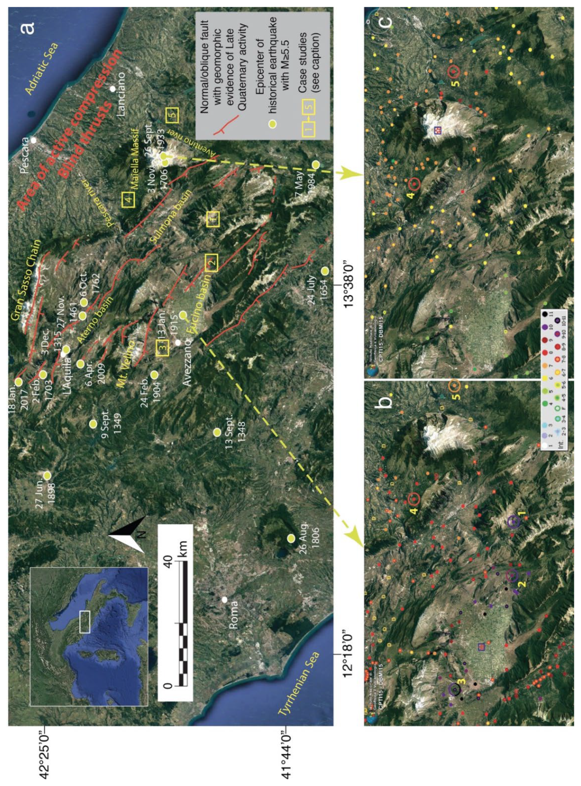
Figure 1. (a) Location map and seismotectonic framework of the investigated area: the main normal or oblique faults responsible for the displacement of Late Quaternary sediments and landforms in the Abruzzi region are reported, together with the epicenters of earthquakes with magnitude M ≥ 5.5 as derived from the seismic catalog CPTI15 [15]. The easternmost area is characterized by compressive tectonics and Quaternary blind thrust faults not emerging to the surface. (b) Intensity datapoint distribution (Mercalli–Cancani–Sieberg, MCS scale) of the 13 January 1915 earthquake (Mw 7.1), according to the macroseismic database DBMI15 [26]; numbers define the case studies discussed in the text. (c) Intensity datapoint distribution (MCS scale) of the 26 September 1933 earthquake (Mw 5.9) according to the macroseismic database DBMI15 [26]; numbers define the damaged localities discussed in the text.
Sustainability 14 09517 g001
Figure 2. Abandonment and resettlement of Frattura. (a) Location of the original settlement (red ellipse) and the provisional (dashed yellow ellipse) and definitive (yellow ellipse) villages following the 1915 earthquake; the largest landslide scarp borders the portion of Mt. Genzana slope, which fed the Scanno landslide during the Holocene (probably before 3000 BP [48,49]). (b) Panoramic view of the original settlement showing the buildings in a ruined condition founded on the small relief and some houses recently restored in the flat area in the foreground, close to the vegetable gardens. (c) Remains of the bell tower (church of San Nicola) in the old settlement. (d) Remains of walls colonized by vegetation in abandoned Frattura. (e,f) Buildings of the definitive village where few tens of residents are presently living. (Photos, F. Galadini).
Sustainability 14 09517 g002
Figure 3. Historical photographs of Frattura. (a) The old village before the 1915 earthquake showing people involved in agricultural works (from Museo delle Arti e Tradizioni Popolari, Frattura). (b) The village strongly damaged by the earthquake (from a postcard edited by the Scanno municipality in 2015).
Sustainability 14 09517 g003
Figure 4. Abandonment/resettlement of Frattura and geological/geomorphological features. (a) Panoramic view showing the main scarp of the Scanno landslide and the geomorphological features indicating the presence of deep–seated gravitational deformations; the entire western slope of Mt. Genzana can be considered to be affected by this kind of instability of the carbonate rock mass. (b) Outcrop of Early Pleistocene breccias representing the substratum of Frattura Nuova. (Photos, F. Galadini).
Sustainability 14 09517 g004
Figure 5. Abandonment and resettlement of Sperone. (a) Location of the medieval settlement (red ellipse), the early built-up area following the 1915 earthquake (dashed yellow ellipse), and the final village built during the 1960s (yellow ellipse). The ancient settlement was located at the southern termination of the Serrone relief, characterized by the active fault and the related bedrock scarp along the SW slope, and by the evidence of gravitational trenches indicating ongoing lateral spreading phenomena. (b,c) Remains of buildings in the abandoned medieval village. (d,e) Remains of the small houses in the abandoned village built after the 1915 earthquake. (f,g) Buildings of Borgo Sperone related to the final resettlement of the 1960s. (Photos, F. Galadini).
Sustainability 14 09517 g005
Figure 6. Abandonment and resettlement of Albe. (a) Location of the medieval settlement (red ellipse) and the village built after the 1915 earthquake (yellow ellipse). (b) Geological sketch and section (vertical exaggeration: 1.5× of the area including the carbonate hill of medieval Albe and the main archaeological area of Roman Alba Fucens (Piano di Civita). (c) Panoramic view of the remains of Albe after archaeological excavations during the first decade of this century; the nave of the church (dedicated to San Nicola) is in the foreground while the remains of the castle in the northern sector of the village dominates the ruins; the northernmost segment composing the seismogenic fault of the 1915 earthquake is exposed at the base of the southern slope of Mt. Cafornia and Magnola Mts., in the background. (d) The church of San Nicola in the village built after the 1915 earthquake; the rose window and the portal of the ancient church destroyed by the earthquake have been included in the façade of the new building. (e,f) Typical small buildings of the reconstruction following the 1915 earthquake in the new village of Alba Fucens. (Photos, F. Galadini).
Sustainability 14 09517 g006
Figure 7. Views of medieval Albe preceding the 1915 earthquake. (a) Panoramic view (from south) of the hill dominated by the bell tower of the church. (b) View of buildings and the main road of Albe perpendicular to the façade of the church dedicated to San Nicola [photo available at Istituto Centrale per il Catalogo e la Documentazione, Rome, Italy]; the rose window and the portal were recovered after the earthquake destruction and included in the façade of the new church (Figure 6d).
Sustainability 14 09517 g007
Figure 8. Abandonment and resettlement of Salle. (a) Location of the medieval settlement (red ellipse), a nearby hamlet (dashed red ellipse), and the village built after the 1933 earthquake (yellow ellipse); a geomorphological sketch of the instability phenomena is proposed; the asterisk indicates the landslide accumulation showed in Figure 9b. (b,c) Remains of buildings in the ruined village. (d) The town hall in new Salle, built in 1937–1938. (e) Buildings of new Salle. (Photos, F. Galadini).
Sustainability 14 09517 g008
Figure 9. Geological aspects of medieval Salle. (a) Right flank of the Rio Maggio valley made of ancient landslide deposits fed from the eastern slope of Mt. Morrone and representing the foundation soil of medieval Salle. (b) Landslide accumulation of 1906, partly filling the Rio Maggio valley, as visible today.
Sustainability 14 09517 g009
Figure 10. Historical photographs of medieval Salle. (a) Panoramic view of the village published in 1910 by Almagià [38], showing the relationship between buildings and the unstable right bank of Rio Maggio. (b) Panoramic view of 1939 showing that part of the village between the church and Rio Maggio had been demolished at that time, following relocation of people in the new settlement (by courtesy of Salle municipality).
Sustainability 14 09517 g010
Figure 11. Abandonment and resettlement of Gessopalena. (a) Location of the medieval settlement (red ellipse) and the village built after the 1933 earthquake (yellow ellipse); the area already urbanized before the 20th century, external to the hill of the medieval settlement, is also indicated together with the main adverse geomorphological conditions; the white asterisk refers to the location of the church of Santa Maria Maggiore mentioned below. (b,c) Views of the archeological area including remains of medieval Gessopalena. (d) Buildings of the new village following the 1933 earthquake, in the northern sector of the area, encircled by the yellow ellipse. (e) Houses of the 1954 reconstruction plan, built in the southern sector of the area, encircled by the yellow ellipse. (Photos, F. Galadini).
Sustainability 14 09517 g011
Figure 12. Instability phenomena on the hill of medieval Gessopalena. (a) Toppling of gypsum blocks. (b) Displacements of the gypsum substratum and of a stone masonry wall due to lateral spreading. (Photos, F. Galadini).
Sustainability 14 09517 g012
Figure 13. In Gessopalena, portal of the ancient church of Annunziata in the original location (a), presently located, since 1927, along the left wall of the church of Santa Maria Maggiore (b), in the modern village (white asterisk in Figure 11a). ((a) Postcard from Archive of Soprintendenza Archeologia, Belle Arti e Paesaggio per le Province di L’Aquila e Teramo; (b), photo by F. Galadini).
Sustainability 14 09517 g013
Figure 14. Chronological scheme summarizing episodes of the history of damage, abandonment, and resettlement of Frattura, Sperone, Albe, Salle, and Gessopalena.
Sustainability 14 09517 g014
Figure 15. Flowchart illustrating a proposal to protect and promote the remains of the abandoned villages. Together with the current built-up areas following resettlement and the geomorphological evidence of natural hazards, the remains should be the object of territorial education projects promoting ecomuseums. The final perspective is represented by the growth of the awareness of seismic hazard and risk in people living in seismic regions.
Sustainability 14 09517 g015
Publisher’s Note: MDPI stays neutral with regard to jurisdictional claims in published maps and institutional affiliations.