Abstract
Several theoretical and applied studies are concerned with the topics of geological heritage management and geoconservation. The diversity of natural and anthropic scenarios into which geological heritage is inserted, as well as its troublesome management, make these topics challenging for scientific discussion. However, on the other hand, these topics highlight the complexity of a theoretical schematization of approaches and procedures, as well as of the practical application of theoretical assumptions. This paper concerns a practical application of a case study in geoconservation actions, which begins with the identification and the basic description of a site of multicultural interest (characterized by the coexistence of geo and non-geo aspects); subsequently, the needs and aims of the potential end users and stakeholders are analyzed. Finally, several geoconservation actions, differentiated according to end user and stakeholder goals, are proposed. The chosen area includes the Craco ghost town in southern Italy. It is a characteristic, evocative place, where it is possible to observe natural and anthropic contexts. The Craco ghost town is also nationally and internationally renowned, since some movie productions have been set there (such as some scenes in Mel Gibson’s The Passion of Christ movie). In this area, the abBandono vErsus riGenerazIoNe (BEGIN) Project (ROP ERDF Basilicata 2014–2020 interregional and transnational cooperation projects) aims to develop an operative, unequivocal, and multi-layered procedure focused on sustainable management, disseminating knowledge and enhancing and using the cultural context of abandoned sites as an attractive force for tourist purposes.
1. Introduction
A wide scientific output concerns the topics of the definition, classification, and management of geological heritage, as well as geoconservation [1,2,3,4,5,6,7,8,9,10]. As Ref. [10] affirmed “Geodiversity is the totality of abiotic nature, of which some elements have significant value requiring conservation, termed Geoheritage, which is managed in Geosites, that are either formally protected areas or are conserved areas, under the generic label Geoconservation. The overriding purpose of Geoconservation in protected and conserved areas is to conserve geoheritage and geodiversity located in geosites”. Several studies on the definition, classification, and evaluation of geosites can be found in the literature [11,12,13,14,15,16,17,18,19,20,21,22,23,24,25,26,27,28,29,30,31,32,33,34,35,36,37]. Among these, Brilha (2016) [33] highlighted that “many inventory works apply the same criteria regardless of the value of the sites that are being inventoried and this may lead to erroneous results. For instance, the justification of beautiful scenery for the selection of a potential geosite is completely irrelevant because the scientific value is independent of the visual beauty of the site. On the contrary, it is a pertinent criterion to identify a site for tourism use”. According to [33], the term geoheritage only refers to those elements of high scientific value, associated with geosites, and the term geodiversity sites identifies sites featuring other values (didactic, aesthetic, touristic). The author proposes a classification according to the object to be classified—geosites or geodiversity sites—outlining distinct significant values (the geosites’ representativeness, integrity, rarity, and importance for scientific knowledge; the geodiversity sites’ didactic potential, geodiversity, accessibility, and safety). If the term geoheritage refers only to elements of high scientific value, is there a way to identify those ones contributing to determining the importance of a geodiversity site, albeit that they do not share a high scientific value? The geocomponents of geodiversity are excessively long, and geocomponents are part of the geoheritage as well. Also, linking the word geoconservation exclusively to geoheritage and geosite can lead to a narrowing of the term’s meaning, given that even geodiversity sites can be the subject of actions dedicated to their abiotic aspects’ conservation. In this paper, we use of the term geoheritage in its broadest sense, also applying it to geodiversity sites.
The potential value of a geosite/geodiversity site varies also according to the potential stakeholders’ needs. An enthusiast, a tourist, or a scholar will not share the same interest in the same site. Therefore, end users should have access to material tailored on their needs and expectations. Discussing methods of geosites’ or geodiversity sites’ potential value’s classification and definition is not a purpose of this paper; rather, to outline that the topic of a multidisciplinary and multicultural approach, differentiated according to the purposes and the stakeholders, is strictly linked to geoheritage management and geoconservation actions and also to territorial/heritage sustainable management. Geoconservation should not be confined to the scientific research field s.s. or designed solely for an object’s physical conservation. Also, geoconservation should concern “intangible” conservation, represented by both multimedia texts and contents, which current technologies can create and offer (see, e.g., the increasingly available bibliography on virtual geosites and related topics as in [37,38] and the references therein), also aimed at conservation and dissemination and the correct and inclusive use of geoheritage. As Pescatore et al. (2023) [39] outlined, during geoconservation actions, geosites and geodiversity sites must be analyzed within the context of the physical landscape in which they are inserted, highlighting both biotic and abiotic components and the impact of anthropic component. Recently, scientific research has begun to show a growing interest in the close correlation between geological heritage and the human sphere as well, in terms of geosite, geodiversity, and cultural landscape conservation actions, urban geological heritage, and geotourism definition [40,41,42,43,44,45,46,47,48,49,50,51,52,53,54,55], and the impact that human actions exert on an area and its heritage. The impact that humans exert on the cultural heritage in general, and on the abiotic and biotic natural one (geoheritage and bioheritage) in particular, shows different aspects and facets, which sometimes oppose each other. On the one hand, there is the role humankind actively played in modifying the landscape to satisfy its needs, which was exponentially enhanced through evolutionary and technological progress ([56,57,58,59] and references therein). On the other hand, there is the growing awareness of the need to establish policies and actions for the conservation and protection of the environment humans live in (e.g., see https://www.iusinitinere.it/agenda-2030-and-the-international-environmental-awareness-27974, accessed on 30 January 2023). Multiple attempts to mediate between these needs, both from a theoretical and practical point of view, through multidisciplinary studies, international, national, and local environmental management policies, and environmental awareness promotion, are placed between these two extremes. The several initiatives also include geotourism promotion, as defined by [43] “The provision of interpretive and service facilities to enable tourists to acquire knowledge and understanding of the geology and geomorphology of a site (including its contribution to the development of the Earth sciences) beyond the level of mere aesthetic appreciation”, through which the geo aspect of an area can connect to different multicultural contexts, leading the tourist along evocative itineraries and generating a profusion of experiences. The purpose of this paper is to demonstrate the practical application of the method outlined in [39] for conducting geoconservation studies. The quoted paper provides a detailed, step-by-step methodology that is designed to identify and define all cultural aspects that are unique to a particular area of study. The methodology aims to emphasize the role of geo context and the significance of these cultural aspects to the wider public and ensure their preservation. The area under consideration includes the ghost town of Craco (Southern Italy, Basilicata region, Matera district, Figure 1), chosen as Project BEGIN’s test site (https://web.unibas.it/begin/?page_id=108, accessed on 30 January 2023). The aim of the project is to develop a sustainable management process that uses the cultural context of abandoned sites to disseminate and improve multicultural knowledge and make abandoned sites attractive for tourism purposes. This project emphasizes the importance of removing physical and cultural barriers preventing access to the sites, through highly technological services.
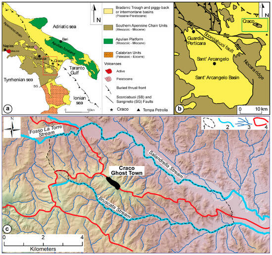
Figure 1.
Location of the study area (a) within the Southern Apennine Chain, (b) relative to the Sant’Arcangelo basin, and (c) within the hydrographic network. The red rectangle in (a) indicates (b)’s boundaries. The green rectangle in (b) indicates (c)’s boundaries. Legend in (c): 1 Craco Compound Geomorphosite; 2 main stream; 3 hydrographic network; 4 surface watershed. Note that in (b) just the bedrock deposits (Apenninic units) are represented for the study area, and not the Pliocene ones, in order to emphasize its structural asset.
The study of the area follows a procedure including the following: (i) defining its main components (geo and non-geo); (ii) describing and characterizing them in the area’s evolutionary context; (iii) identifying possible topics and itineraries for research, dissemination, protection, and geotourism; and (iv) defining and proposing geoconservation interventions. What follows refers to the geological context. However, it may refer to other contexts (bio, archaeo, etc.) through proper remodeling and adaptation, since the procedure is not tied to the main topics or subjects covered. We anticipate that anthropic structures can be found in the area under consideration. They are linked to hillslope stabilization, and they allow us to definitively rebuild the timeline of the events that have led people to abandon the town. Thus, they bear witness to the stabilization techniques used, their inefficiency, and the place’s history. In this context, it is not yet clear how to consider this kind of structure, such as other industrial archaeological ones (dams and associated structures, etc.). These structures are historically and culturally interesting, and closely linked to geo context: they are functional to it and strongly impactful on the area. Hence, two provisory terms are used: (i) Anthropoheritage (AH), referring, in the broadest sense of the term, to the anthropic heritage of cultural interest, built, manufactured, or created by modifying the landscape without the making of buildings or artefacts; (ii) AnthropoGeoHeritage (AGH), referring to those structures whose function is closely connected, and functional, to the geological context. We are aware that the term AGH may cause confusion and seem like a stretch. We believe that this type of structure (AGH) must be included in the geoconservation actions’ topics and must have a different approach compared to generic AH (i.e., such as Built Heritage), highlighting their links with the geo context and their potential as attractors for scientific, educational, and tourist contexts.
2. Materials and Methods
The approach to the study of geoheritage is both interdisciplinary and multidisciplinary. First, because it involves several Earth science disciplines; second, since it can include other scientific and humanistic disciplines as well. The approach to geoconservation is similar. Although geoconservation actions primarily aim to preserve geological heritage, at the same time, they can preserve the bio-natural and cultural heritage. Moreover, they represent an opportunity for multicultural dissemination. Several activities carried out by Geoparks afferent to UNESCO Global Geoparks (UGGp, https://en.unesco.org/global-geoparks watched on 5 January 2023) include a multidisciplinary approach, in which the heritage’s geological aspects represent a starting point to introduce either historic–cultural, architectural, or natural content. Also, the activities of the National Italian Parks and Marine Protected Areas (https://www.mase.gov.it/aree-protette watched on 1 October 2023), and Regional Parks and Protected Areas, adopted this kind of approach as well.
For the purposes of this paper, the study area will be described using the definition provided for Compound Geomorphosite in [60]. The term Compound Geomorphosite emphasizes “an area chosen and delimited on the basis of a prevalent geomorphological component that can include different cultural contexts, geo and no-geo” features (Figure 2). Terms such as geosite/areal geomorphosite/complex geomorphosite or geodiversity site do not fully express the area’s multicultural potential, since they are mainly associated with geo components. Geocultural site [35] is the term that most closely resembles the meaning of Compound Geomorphosite; it is focused on the geomorphological and archaeological/historical value of a site/ area; therefore, it is supposed not to be applicable in the absence of the latter or in the case that they have an irrelevant value. In terms of conserving geological features, whether they are singular points or areas, the boundaries of the area to be considered should be the same as those of the catchment basin portion (or catchment basins), in whose area of influence the feature falls. Within a Compound Geomorphosite, geo(morpho)sites should be delimited according to the proposal in [61]. As regards geotourism, according to [46] “For the purposes of geotourism, it is suitable to use the term “geodiversity sites” or “sites of geotourist interest” because both geosites sensu stricto and other types of the sites can be considered”.
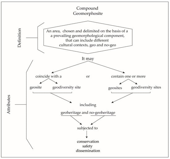
Figure 2.
Definition and attributes of Compound Geomorphosites. Note that the term geosite is used broadly, encompassing both geosites and geomorphosites.
By considering the multicultural heritage of an area as a whole, we can shape and modulate the different elements to meet the needs of the end users. The geomorphological component is fundamental in the Compound Geomorphosite definition, since the landscape, thanks to its shapes and dynamics, is what mostly strikes the sense shared by all final users’ categories, the sight. A Compound Geomorphosite may coincide with a geosite or with a geodiversity site, or it may include one or more geosites or geodiversity sites.
The Craco Compound Geomorphosite (Figure 1c) contains the Craco Geosite, included in the ISPRA National Italian Inventory of Geosites (http://sgi.isprambiente.it/geositiweb/default.aspx 15 October 2022) and in the Basilicata regional catalogue of geosites (https://rsdi.regione.basilicata.it/geositi/ watched on 15 October 2022). Table A1 provides a list of the main cultural contexts here available: the green-colored ones represent the contexts discussed in this paper. According to [39], several steps, including Basic Geoconservation, Applied and Popularizing Geoconservation, and Technical Geoconservation, characterize the study of this area. The main topics of each step covered by the study are summarized below. Topics will be intentionally condensed as much as possible, in order to provide a global idea of the procedure and its application. Figure 3 schematizes the main actions of the three geoconservation fields discussed in this paper. In this paper, Basic Conservation actions refer both to geo and non-geo contexts; Applied and Popularizing Geoconservation actions and Technical Geoconservation mainly refer to the geo context. Generally, programmed actions can (1) directly—and materially—concern the geoconservation of an object or an area, and/or (2) indirectly contribute to conservation and an increase in knowledge through dissemination. What follows will merge into a dedicated website and will be available to the final users, who may choose which content to view, according to their needs.
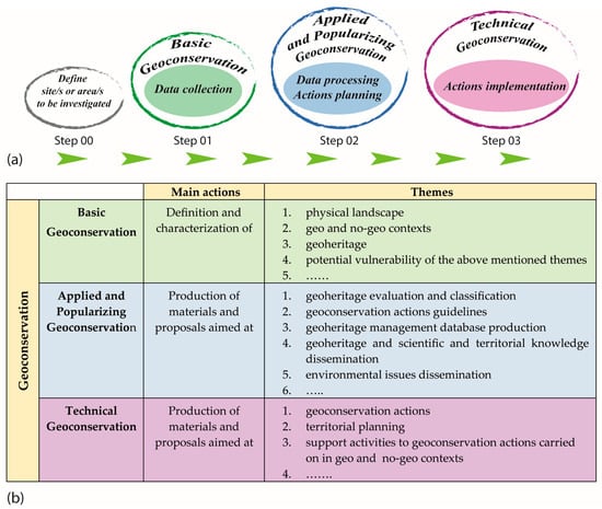
Figure 3.
(a) Flow diagram showing the steps involved in the process. (b) Main actions and themes in Basic, Applied and Popularizing, and Technical Geoconservation. Themes can be expanded based on site’s characteristics, indicated by ellipses (…).
3. Step 00 Area Description and Choice Reasons
The ghost town of Craco is a characteristic and evocative site, where it is possible to observe natural and anthropic contexts. Craco is also nationally and internationally renowned, since some movie productions have been set there (such as some scenes from Mel Gibson’s movie “The Passion of Christ”). The ghost town is perched on a NW-SE-oriented rocky ridge, with the NE side facing onto the Salandrella stream. Little information is available about Craco’s origins [62]. A necropolis dating back to the 8th century, located in Contrada S. Angelo, brings the hypothesis that there was a settlement, which played an important role in monitoring the area due to the strategic position of the rocky ridge [63]. Just to the south, after the confluence of the Salandrella and Bruscata streams, outside the study area, Tempa Petrolla (Figure 1b) represents a further rocky ridge, perhaps a former monitoring site (https://patrimonioculturale.regione.basilicata.it/rbc/upload/file_1456392358743.pdf, accessed on 30 January 2023). The ghost town retains the original medieval structure. Its layout features a Norman tower, bearing witness to the settlement’s monitoring role over the area [62,63,64,65]. The Compound Geomorphosite of Craco (Figure 1c) is located between the Salandrella stream to the west, the Bruscata stream to the south, and the Fosso la Torre stream to the north. To bound the study area, the hydrographic network, and the corresponding basins influencing its evolution, were taken into account. In this area, the ridge beneath Craco represents a superficial watershed; different hydrographic basins influence its sides and therefore the entire area. The ridge consists of different lithologies, well exposed and observable both along natural and artificial cuts, which are responsible for its current conformation. Several landslides have affected the entire area; for a long time, the landslides constantly reactivated, threatening Craco’s stability, in particular, the ridge’s south-western side. The landslides persisted since late 1959, until the citizens were forced to leave most of the town and until they totally moved between 1965 and 1980. In [65], a detailed framework concerning events and interventions was provided for the study area, The landslides affecting the area have been studied and researched over the years, since they caused the first damage to anthropic structures. The attendance of elements of geological, biological, and anthropological interest, the availability of bibliographical material, and the notoriety of the place are the reasons for choosing the place as study area.
4. Step 01 Basic Geoconservation
This first step defines the main abiotic and biotic components of the physical landscape (PL, Figure 4) of the area under consideration. It includes the following: (i) gathering the currently available papers on the area; (ii) defining the main aspects of the geological context; (iii) describing the elements’ (geo and non-geo) main aspects as potential objects of conservation actions; and (iv) identifying their potential critical issues.
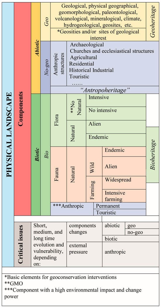
Figure 4.
Physical landscape (PL): Components and main critical issues. Geosites are considered from a general point of view, as belonging to the PL’s abiotic component geo context, then from a detailed point of view, as basic elements for geoconservation interventions. The anthropic aspects are considered as belonging (i) to the abiotic component (anthropic structures) and (ii) to the biotic component; in both cases, they are considered as components with a high environmental impact and change power on PL. Note that the list of Anthropic structures is not exhaustive and can be expanded based on the site’s characteristics, indicated by ellipses …
4.1. Physical Landscape: Abiotic Components
4.1.1. Geo Context
- Available bibliography
Table A2 displays the main papers available, listed in chronological order according to their publication date. It covers both specific papers and general ones.
- Geology
The ghost town of Craco is located on a NW-SE-oriented rocky ridge, in the Bradanic Trough, near the buried front of the Southern Apennine chain (SAC) (Figure 1a).
The SAC’s frontal portion, made up of allochthonous imbricate thrust sheets, tectonically overlies the Pliocene–Early Pleistocene foredeep deposits of the Bradanic Trough, which in turn rests on the Apulian shelf, affected by high-angle normal faults [66,67]. The allochthonous units are covered by Plio-Pleistocene deposits and together are deformed by tectonic structures linked to the chain’s advancement, so that the chain’s frontal portion is buried under the foredeep deposits. Wells built for oil exploration provided a lot of data that allowed the creation of a deep structural model highlighting the presence of the buried front. The presence of deformed Early Pleistocene deposits at the thrust front indicates that the stacking of allochthonous units continued until the Middle Pleistocene [66,67,68,69]. In the Craco area, important tectonic structures emerge, bringing out the buried allochthonous units where Plio-Pleistocene deposits are prevalent. The tectonic setting is closely linked to the deformation of the SAC’s frontal portion, following the progressive advance of the allochthonous units towards the foredeep basin. The Craco area is located near important N100–N110-oriented strike-slip structures that displace the folds and thrust faults of the Apennine chain. These strike-slip faults determine a considerable rejection in the buried front of the allochthonous and have generated a triangular zone, in which the back thrusts join in depth to the basal decollement surface [70].
In the Craco area, the outcropping lithologies can be grouped into (i) allochthonous units, Cretaceous–Oligocene in age (Argille Varicolori, according to [71]) and (ii) two cycles of Plio-Pleistocene deposits, unconformably lying on the previous units and separated by an unconformity, visible along the north-eastern slope of Craco [72,73,74,75,76,77,78]. Overall, the allochthonous units can be assimilated into a tectonic mélange [78]. Two different interpretations regarding the age of the Plio-Pleistocene deposits are reported in the literature. According to [72,73] the first cycle can be referred to the lower Pliocene, while the second cycle can be attributed to the middle-upper Pliocene. Patacca and Scandone (2001) [74] re-allocate the two cycles, which are referred, respectively, to the upper Pliocene and the lower Pleistocene. The outcropping successions are referred to as (i) Cretaceous to Lower Miocene formations, known as Gruppo delle Argille Variegate (AV), and (ii) Plio-Pleistocene formations, which include the Bradanic foreland (ASP upper Pleistocene) and intrachain basins (GCR and ARM, early Pliocene and upper Pliocene to lower Pleistocene, respectively) (ISPRA, 2014) [75]. ASP deposits unconformably lie on ARM; GCR deposits unconformably lie on AV and consist of three lithofacies: conglomeratic (GCRa), marly-sandy clays (GCRb), and sandy-calcarenite (GCRc). The presence of two volcanoclastic levels of metric thickness represent important stratigraphic markers within the succession [78]. Differences exist in the reconstruction of the ridge’s structure: (i) it features a normal fault oriented to the west, separating AV deposits from the still clay ARM ones [75], or (ii) thrusts with opposite vergence enclose the structure, causing on the western side the mainly clay deposits and their GCR conglomeratic deposits to overlap with ARM, and causing on the western side the AV to overlap with GCR and ARM [70].
In the study area (Figure 5), the deposits related to Argille Varicolori Auct. consist of red, green, and grey clays, and siliciferous limestone, and calcilutite layers and multi-colored jaspers featuring a chaotic structure; carbonate and arenaceous olistolites are also observable. The lower cycle (early Pliocene) is composed of lenticular conglomerate bodies with sandy intercalations that pass upwards to bioclastic sands, informally defined as “lower sands”. Conglomerates consist of calcareous, marly, and arenaceous elements, ranging in size from 2 to 39 cm. They are immersed in a sand–clayey matrix, cemented at times. Clays are marly–sandy; their color is grey, yellowish by alteration, with diatomite levels or interspersions of sandy levels at times. Sands are rich in quartz, at times rich in molluscs, brachiopods, and bryozoans bioclastic. The central portion of the cycle is made up of marly clays with sandy horizons, followed by another level of bioclastic sands, called “upper sands”. The thickness of the entire cycle can be estimated at around 350 m. This succession is clearly visible along the south-western slope of Tempa San Lorenzo and along the north-eastern slope of the Craco ridge. In the latter locality, all the units that make up the succession are visible, even if there is a horizon composed of Varicolored Clays, apparently interspersed within the marly clays. The upper cycle (upper Pliocene) is mainly made up of grey marl clays with interbedded sands, and it is characterized by the presence of two volcanoclastic levels of metric thickness, which represent two important stratigraphic markers within the monotonous lithologies that make up this succession, as reported in [78].
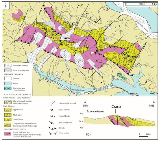
Figure 5.
(a) Geological map of the Craco area and (b) cross-section highlighting the main tectonic and stratigraphic features.
Along the north-eastern slope of the Craco hill, the basal portion of the upper cycle is sometimes marked by a sandy interval, which has little lateral continuity, as it rests in onlap on the sands of the lower cycle.
- Geomorphology and slope evolution
The ridge on which the ghost town of Craco is located clearly stands out in the landscape. With its shape elongated towards a NW-SE direction, the ridge reaches an altitude of 391 m asl and represents an observation point on the surrounding area. The area lies within the Salandrella stream basin. The ridge delineates the watershed between the Salandrela stream and the sub-basins of Fosso la Torre and Bruscata streams (Figure 1c and Figure 6). The topographic slope profile of the Craco ridge is very irregular, with steep sections in the upper part and less sloping in the medium–lower part.
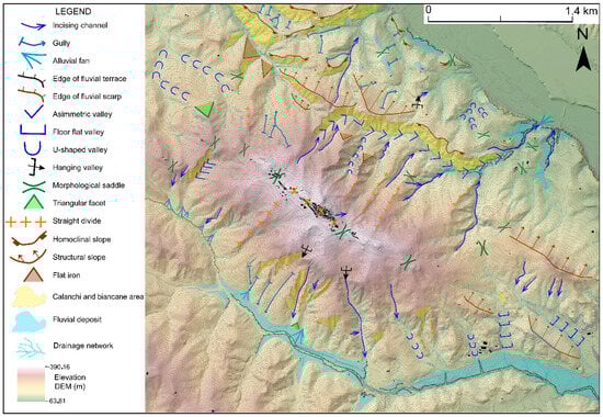
Figure 6.
Hillshade and geomorphological map of the Craco area and surroundings.
The current shape of the landscape is due to the nature of the several emerging lithologies. The central part of the ridge consists of the most competent conglomeratic lithologies, while mainly clayey lithologies emerge along the ridge’s sides. Near the conglomerate deposits, affected by a localized fracture network, the sides are particularly steep, featuring sub-vertical walls (Figure 7a). The waster side features conglomerate towers and isolated groups of conglomerates (Figure 7b). The ridge’s sides evolve according to (i) the outcropping lithologies’ nature, (ii) their structural setting and level of fracturing, and (iii) the sides’ slope and exposure. Moreover, they evolve through mass gravitational movements, which are triggered and evolve in several ways. The side’s portions featuring conglomeratic lithologies primarily evolve through collapse and lateral expansion phenomena, favored by the presence of an intense fracturing network affecting these lithologies [54]. On the other hand, the portions featuring clayey lithologies evolve through superficial and deep mass movements that are deep in the initial stretch and superficial in the medium–lower one.
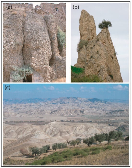
Figure 7.
(a) Fractured conglomerate vertical walls; anthropic cavities are present at the base of the walls and, towards the top, houses are built on them; (b) conglomerate peaks; (c) badlands.
The north-eastern slope of the ridge has an average slope of about 13°, and it is affected by numerous landslides, some of which develop along the entire slope until they reach the valley floor, first involving the conglomerates and then the clayey deposits. The lower part of the north-eastern slope has escarpments modeled on the clayey sediments, characterized by immersion opposite to that of the slope, and with exposure towards the southern quadrants. The escarpments are affected by badland landforms (Figure 7c) that sometimes extend for several hundred meters. At the foot of the same slope, there is a flat area occupied by the wide ordinary bed of the Salandrella stream and its Holocene terraces.
The south-western side of the Craco ridge has an average slope of about 11°, and it is affected by landslides, attributable to the same types, trigger and evolution, but with larger dimensions than those detected along the north-eastern side. Many landslide bodies develop along the entire slope, affecting the conglomerates, which emerge at the top of the ridge; the Varicolored Clays unit, located halfway up the slope; and the Pliocene clays unit outcropping in the lower part. Furthermore, a large part of the same slope is affected by a deep-seated gravitational slope deformation (DGSD). Figure 8 shows the elaborate landslides map for the study area. In [65], a detailed landslides chronology is provided, from 1870 to 1983. The authors also pointed out, in detail, the consolidation works following the landslide events and their evolution over time.
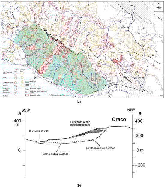
Figure 8.
(a) Landslides map of the Craco area, the direction of cross section in (b) is shown by the A-B profile; (b) geomorphological cross-section along the south-western slope.
- Climate
In order to frame the current climate of the area, the data of the Craco Peschiera (40°22′ lat and 16°50′ long) thermal–pluviometry station of the Sistema Agrometereologico Lucano (Lucanian Agrometeorological System) network was taken into account (Figure 9). The thermal–pluviometry set covers a 23-year period, from 2000 to 2023. The average annual temperature fluctuates around 14.3 °C. January is the coldest month, with an average temperature of 7.4 °C; August is the hottest month, with an average temperature of 25.5 °C. Average annual rainfall is 513.9 mm. The pluviometric regime is sub-equinoctial, almost Mediterranean, with an absolute maximum value of 66.7 mm in November, a relative value of 50.2 mm in March, and a minimum value of 14.6 mm in July. The aridity index value of De Martonne (ia) was equal to 20, identifying a sub-humid/semi-arid Mediterranean climate. It creates stational conditions suitable for the creation of formations on the boundary between the “prairies” and “scrubland” types. The analysis was deepened by calculating Emberger’s pluviometric quotient (q2), which represents the overall drought in a Mediterranean climate. The calculated quotient’s value (62.32) outlined that the station belongs to the sub-humid Mediterranean climate, whose limits lie between 50 and 90, according to the author’s classification. Inserting the obtained q2 value in Nahal’s climate diagram, and relating it to the value of the coldest month’s average minimum temperature, led to the conclusion that the bioclimate is mainly xeric, proving to be semi-arid and temperate. In order to complete the climate framework, the Thornthwaite humidity index (1948) was calculated. The obtained value (hi = −36) identifies a clearly xerothermic type of climate.
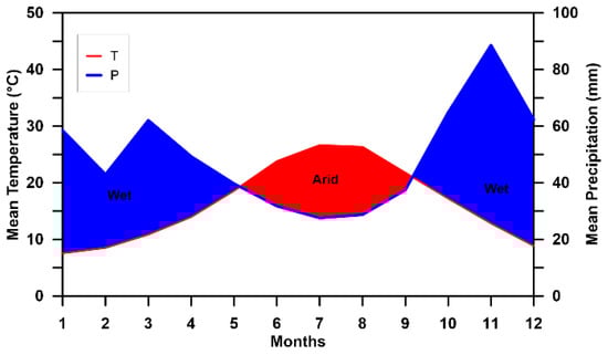
Figure 9.
Climate thermo–pluviometric trend of the Craco area.
- Geosites
In the ISPRA National Inventory of Geosites (http://sgi.isprambiente.it/GeositiWeb/default.aspx?ReturnUrl=%2fgeositiweb%2f, accessible after registration on the site), Craco is included in the Basilicata Region database, identified as a geosite of leading scientific–structural, scenic, and regional interest.
4.1.2. No-Geo Context
Artificial abiotic elements belong to this context. They are man-made and represent an integral part of the PL. Anthropic structures are subject to the activity of the landscape’s modeling forces, as well as other geo elements. Moreover, they can exert a “pressure” on the landscape. The pressure can be either positive, preserving the landscape’s conservation, or negative, increasing or modifying the activity of the modeling forces, causing the landscape to deteriorate. Paradoxically, in general, the coverage of an urban tissue prevents rainwater from infiltrating the substrate it stands on, allowing it to preserve it, provided that the rainwater is properly controlled and channeled, preventing circumstantial or spread infiltration, and that there are neither water, sewage, nor gas leaks. Of course, isolated anthropic structures represent a different case. If they are smaller than the reference drainage basin (i.e., a rural church, a containment or drainage work), the modeling forces’ action is usually heavier than the potential “pressure” the anthropic structure can exert in the short- and medium-term. If they are larger (i.e., an industrial/ecclesiastical/touristic complex, a dam, a bridge), the pressure they exert can significantly influence the landscape’s evolution. Thus, anthropic structures should be categorized according to their dimension/extension, in addition to their purpose/usage and conservation conditions.
- Anthropic structures
Anthropic structures under consideration are (i) the old town of Craco’s urban area, (ii) the landslide’s adjustment works, and (iii) the landscape’s transformation works (a) related to the construction of a sports field and (b) represented by dry stone walls related to agricultural activities.
Historical Urbanistic Background
The urban generating nucleus of Craco developed around the Norman tower (Figure 10a), built in the 12th century on top of the hill, on an area characterized by good geological–geotechnical features, as proven by the fact that it would not been affected by landslides occurred in the 20th century. In the Middle Ages, the habitation site and the tower were already visible landmarks, as is mentioned in the travel diary of the Arab geographer Idrisi, who visited or simply observed them in 1154. The urban layout most probably underwent an expansion in the 13th century, a period in which around 400 inhabitants lived there, as can be seen from the focal taxation of 1277, which reports a number of 83 tax ‘fires’. The urban design of this period is characterized by a circular annular morphology, as a result of a construction choice to adapt to the topographical features of the hillside. The most important demographic development took place in the 16th century, during which there was an increase in the population to about 2500 inhabitants in 1561, which is why the settlement expanded downwards, reaching the present Largo Garibaldi and Largo Alighieri, continuing along Via Pinelli and Via Filangieri. Summarizing, from an architectural point of view, Craco is the result of historical sedimentation, of which it is possible to recognize the following: (i) a medieval core (11th–14th century) as evidenced by construction elements from this period; and (ii) an expansion between the 16th and 17th centuries, during which the great noble palaces, such as the Grossi Palace and Maronna Palace, were built: the former overlooking the small square where the Mother Church stands, the latter located next to the medieval tower and characterized by a monumental brick entrance, surmounted by a large terraced balcony. Subsequent urban expansions were carried out between the 18th and 19th centuries, as evidenced by the stylistic features found in some buildings. The rest of the building heritage is not influenced by stylistic currents. It is a vernacular Mediterranean architecture that blends in with the striking natural environment characterized by clay gullies and caves, as can be found in many other villages of medieval foundation in Basilicata.
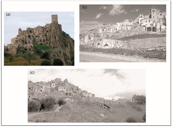
Figure 10.
(a) Craco panoramic view; (b) remains of the wall with arches built in 1888; (c) reinforced concrete breast wall built on piles in1968.
In terms of building types, the settlement consists mainly of two-storey buildings, with brick vaults on the ground floor and wooden beam ceilings on the upper level. The most common type of masonry is cobblestone, in which split and/or hewn stones of random sizes are used, as they occur, to build the courses; the gaps between them are filled with smaller pieces and lime mortar.
Slope stabilization works
As mentioned above, the south-western side of the ridge on which the town stands is affected by several mass movements. The still-visible stabilization works bear witness to the movements’ historical evolution, documented in the municipal archive records. In 1888, an arched wall was built as an attempt to do damage control on the upper houses (Figure 10b). This wall was subject to decimeter shifts soon after it was completed. In 1954, a soccer pitch was built over a landslide terrace on a slight counter-slope, placed below the road S.S. n° 103, leveling an extended area and substantially altering the side’s layout. In 1959, an exceptional rainfall occurred and caused the soccer pitch, the arched wall, and a few houses above the road S.S. n° 103 to destabilize. Between 1963 and 1965, other landslide reactivations led to the collapse of the arched wall, the interruption of the road S.S. N° 103, and the evacuation of 153 houses due to unfitness for use. In 1968, a retaining wall based on piles was built; the piles reached a depth of 30 m (Figure 10c). The further landslide reactivation deformed the wall and affected several houses upstream of the road S.S. n° 103 as well. Eventually, the town was abandoned in 1972.
Sports field
It was built in 1954 on a landslide terrace on a slight counterslope, leveling and modifying the side’s layout. In 1959, due to rainfall of over 400 mm over a 5-day period, there was a reactivation of the landslide affecting the historical center; this caused the destruction of the sports field, a dislocation of the road bridge, and the first damages to the houses upstream of the bridge.
Dry stone walls
The “Art of dry stone walling” was included in the UNESCO List of the Intangible Cultural Heritage in 2008 (https://ich.unesco.org/en/RL/art-of-dry-stone-walling-knowledge-and-techniques-01393, accessed on 10 February 2023) and represents an example of anthropic alteration of the landscape for agricultural purposes. This alteration enhances the sides’ stability, allowing them to be used and cultivated. Dry stone walls are built using local rocks and require knowledge and expertise in using stone material. Their maintenance, albeit limited, must be constant over time, in order to ensure the preservation of the enhancing effect on the side’s stability. In the study area, Pliocene sandstones and Cretaceous calcilutites have been mainly used in limited areas where olive trees are grown.
4.2. Physical Landscape: Biotic Components
- Habitat
The Basilicata Region Map of Nature [79] contains 86 kinds of habitat, charted with adaptations and integrations, according to the classification of the CORINE Biotopes Project (https://www.eea.europa.eu/data-and-maps/data/corine-biotopes, accessed on 15 February 2023) and the instructions provided by APAT (2003, 2004) and ISPRA (2009a, 2009b) [80,81,82,83]. Extensive crops and agricultural systems represent the main macro habitat. Mediterranean subnitrofili a Lygeum spartii L. fields are widespread. This species is typical of the Mediterranean environment and high Mediterranean herb steppes, which, according to EEC Directive 92/43, form primary habitats of community interest (https://eur-lex.europa.eu/LexUriServ/LexUriServ.do?uri=CONSLEG:1992L0043:20070101:ENG:PDF, accessed on 15 February 2023). An extended clay area featuring accelerated erosion (badlands) can be found. In Figure 11, the habitats of the Craco municipality area are shown.
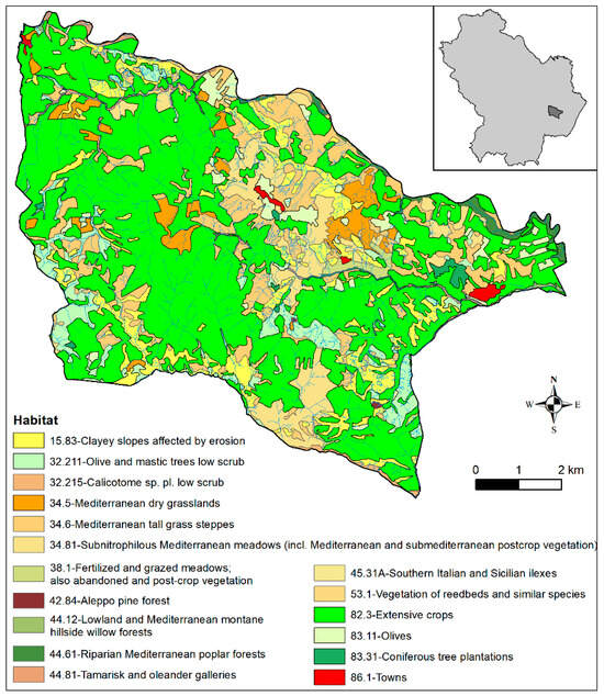
Figure 11.
Map of the habitats related to the Craco municipality area. Data from [79].
- Flora
In the badlands, the vegetation mainly features spring- or autumn-blooming species, with a summer resting phase. Most of them are calcicolous or weakly halophile. They feature an ecological value and have significant pioneering capabilities (stenotops). The badlands species belong to the myalophytes or marginal halophytes classes [84], capable of enduring brackish concentrations of sodium ion, ranging from 0.001% to 1%, typical of salty coastal habitats and brackish lagoons. The occurrence of deep erosional incisions in the badlands promotes the growth of a great number of herbaceous, shrubby, or arboreal species. Arboreal species appear in the lower part of the sides or in the valley floors, while the badlands are normally barren or can solely host small herbaceous or shrubby species. Generally, the badlands and deep erosional incisions offer fundamental reservoirs of biodiversity, since the lack of human disturbance allows vegetation to survive. Herbaceous vegetation mainly consists of Lygeum spartum and Camphorosma monspeliaca (Figure 12a). Where the substrate’s salt content increases, Suaeda fructicosa becomes the prevailing species. In badland valleys, the herbaceous species Lygeum spartum is the dominant species, which creates actual prairies. Hedysarum coronarium, Pisum elatius, Camphorosma monspeliaca, Asparagus acutifolius, Glycyrrhiza glabra, and Daphne gnidium can be found as well. Several Carduus species populate the sunniest sides, from Cynara carduncellus to Silybum marianum, Onopordon Illyricum to Cirsium vulgare, to different Dipsacum and Cirsum species, etc. The lily family is well represented as well. Cistus spp., Viburnum tinus, Origanum majorana, Origanum vulgare, Pulegium sp., Thymus vulgaris, and other aromatic species are quite common. Also noteworthy is the presence of Stipa austroitalica, an endemic species of southern Italy and one included in the EEC Directive 92/43 (https://eur-lex.europa.eu/LexUriServ/LexUriServ.do?uri=CONSLEG:1992L0043:20070101:ENG:PDF, accessed on 15 February 2023). Several terrestrial orchid species can be found, among which are Orchis italica (Figure 12b) Ophrys bertolonii, Ophrys bombyliflora, Oprhys lutea, Ophrys passionis subsp. passionis, Ophrys tenthredinifera, Ophrys fusca subsp. lucana, Ophrys holoserica subsp. apulica, and finally Ophrys terentina. This species is seriously endangered, and it is included in the Italian Flora Red List [85]. The badlands also feature bushes and limited extensions, primarily consisting of Atriplex halimus, Rubus ulmifolius, Crataegus monogyna, Spartium junceum, and Paliurus spina-christi. In particularly eroded areas, the main arboreal species are Atriplex halimus and Spartium junceum. Along the lower areas’ ditches, where the soil is less clayey, Tamarix sp. and Polygonum tenoreanum grow, an endemic Italian species, whose chorological center is the Lucan Ionian side [86]. Along the southern sides, there are Mediterranean maqui areas, dominated by Pistacia lentiscus. Along the northern sides, it is possible to sporadically find Quercus pubescens and Spartium junceum. Some plant species of medical interest are variously spread, for instance, carline (Carlina acaulis), burdock (Arctium lappa), mint (Mentha silvestris), marjoram (Origanum Majorana), Pulegium sp, oregano (Origanum vulgare), thyme (Thymus vulgaris), licorice (Glycyrrhiza glabra), cress (Nasturtium officinale), and nettle (Urtica dioica).
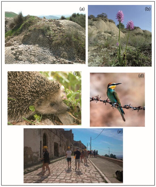
Figure 12.
(a) Lygeum spartum and Camphorosma monspeliaca; (b) Orchis italica; (c) Erinaceus europaeus; (d) Merops apiaster. (Dr. V.A. Romano private archive photo, courtesy of the Author). (e) Craco represents a destination for educational excursions of geological sciences degree courses and secondary education schools involved in several projects.
- Fauna
The depopulation of rural areas, the increase in uncultivated areas, and the spontaneous re-naturalization of some areas, together with the reduction in hunting activities, led to a demographic growth of several animal species. Hedgehogs (Erinaceus europaeus, Figure 12c), martens (Martes foina), weasels (Mustela nivalis), foxes (Vulpes vulpes), hares (Lepus europaeus), and several mustelid species are common. Badland areas represent an ideal resting and reproducing site for several bird species (Figure 12d), so much that they are recognized at European level as an I.B.A. (Important Bird Area, http://www.pcn.minambiente.it/mattm/en/project-nature/#3, http://www.lipu.it/iba-e-rete-natura, accessed on 15 February 2023). Several bird species can be found, from sparrows to birds of prey. The black-headed bunting (Emberizyo melanocepha/al) nidifies in Lygeum spartum prairies. Among nocturnal birds of prey, the area hosts owls, little owls, barn owls, and scops owls. Diurnal birds of prey are widespread as well, among which are kites (Milvus milvus), kestrels, and buzzards. Furthermore, there is the lesser kestrel (Falco naumanni), an African migratory bird of prey, typical of Matera Murge. The presence of the short-toed eagle or short-toed snake eagle (Circaetus gallicus), the lanner falcon (Falco biarmicus), and the Egyptian vulture (Neophron percnopterus) is of great importance. They can be frequently observed flying in the sky. Groups of crows (Corvus frugilegus) and carrion crows (Corvus coronae) can be often seen on the edge of cultivated fields as well. Among herpetofauna, two species of viper (Vipera aspis and V. berus) should be mentioned, the only venomous snakes which can easily find shelter within the clay ravines. Other—nonvenomous—snakes roaming the badlands are the rat snakes (Columber viridiavus) that primarily feed on small reptiles and Elaphe quatorlineata, of considerable size, a skilled swimmer that preys on small mammals and appreciates eggs. The dark or brown grass snake (Natrix natrix), featuring a characteristic yellow “collar” (hence the name), lives in the most humid areas and mostly preys on amphibians, as well as small fishes and mammals. Several small reptiles (such as lizards and green lizards) populate the sunny badlands, along with amphibians (toads, frogs, and tree frogs) croaking in ponds or in the small artificial basins created by irrigation networks in order to control wastewater. In conclusion, in the badlands, there live a wide variety of insects and arachnids, which have not yet been registered and characterized, and which have adapted to these often arid, drought environments.
- Anthropic
The anthropic component divides into two main groups, sedentary and tourist (Figure 12e) The first features the constant, permanent human presence on the area under consideration (residents, workers). The latter can be divided into three macro-categories: Domestic Tourism, Inbound Tourism, and Outbound Tourism [87,88,89]. In their turn, they can be split into additional categories (occasional, seasonal, organized, recreational, cultural, business, athletic, medical, religious, gastronomic, naturalistic, etc.), some of which can be divided into subcategories (e.g., cultural: educational, research, personal culture, thematic, etc.). This paper does not discuss different kinds of tourism: it solely limits itself to dealing with their general aspects.
Sedentary
The anthropic resident sedentary component is located in Craco-Peschiera, where Craco’s inhabitants moved after they abandoned the town. The old town is uninhabited. The sedentary component of anthropic work is linked to the presence of (i) tourist assistance operators, (ii) seasonal agricultural workers, and (iii) commuters who travel along the SS 103 every day.
Tourist
The anthropic tourist component has increased over time. Tourists arrive singularly or in groups to walk the streets of this ancient town, attracted by the evocative places, used as sets for cinema productions as well. Moreover, the site represents a destination for educational excursions of geological sciences degree courses and secondary education schools involved in several projects.
4.3. Physical Landscape: Critical Issues
Without going into the details of hazard, vulnerability, and danger definition and characterization, in general, the hazard may be related to natural or anthropic critical issues. Anthropic activities themselves often influence the bond between natural hazards and human activities—in other words, the effect and the consequences a natural event has on the anthropic context. A poor, inadequate area’s usage and management interventions, as well as excessive and/or improperly contextualized urbanization, can amplify the damages caused by natural events. On the one hand, the hazard caused by human activities is related to the area’s alteration and environmental pollution (water, soil, atmosphere, sound, light pollution) that human activities may provoke. On the other hand, it is related to “ignoring and not understanding” the area and its evolutionary processes, and to “expecting” the area to adapt to anthropic needs. Below, the main natural and human-induced critical issues of abiotic and biotic components are analyzed for the studied area.
- Natural critical issues
Abiotic components
The main abiotic components’ natural critical issues are related (i) to their natural degradation caused by weather (as reported, for example, in [90,91,92]), (ii) to the presence of extended areas affected by soil erosion phenomena, (iii) to the involvement in mass movements phenomena, related to the sides’ natural evolution, and (iv) to seismic damages. In the case of a significant seismic event, the greatest expected damage is related (i) to the historic center’s real estate assets, where some buildings and/or entire areas are in an unsafe state, and (ii) to the infrastructure, represented by roads, by water and electrical supply networks, and by sewerage.
Biotic components
Natural critical issues are common to all biotic components. They are represented by the current climate change and the resulting exceptional drought and precipitation phenomena alternating throughout the year.
- Human-induced critical issues
Abiotic components
The human activities’ sphere of influence manifests itself periodically for agricultural activities and tourism, since there is no resident population and the main urban, industrial centers are distant. Some areas are used for grazing. In these cases, an excessive load of cattle may lead to a worsening of the soil’s features, causing it to compact.
Biotic components
Agricultural activities generate a clear critical issue, since they lead to a decrease in and/or the lack of biodiversity, with a resulting impoverishment of habitats. Most of the crops are arable; there are few areas used for olive, fruit, and citrus groves, which may require the use of chemical substances. The lack of maintenance of the dry stone walls could represent a critical issue for slope stability. Tourists would represent a critical issue if they arrived during the mating and hatching periods of some bird species that nidify on the historical center’s abandoned garrets.
5. Step 02 Applied and Popularizing Geoconservation
The second step includes actions carried out in four distinct macro-areas: Scientific Research, Administrative, Educational and Tourist. The Administrative macro-area includes all the public entities responsible for managing the area and its heritage, in the broad sense of the term.
5.1. Scientific Research Macro-Area
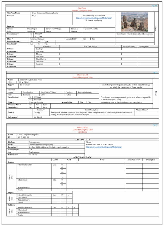
In this macro-area, the actions are devoted to scientific research in the strict sense, to the evaluation and classification of the geoheritage and its dissemination, to the provision of material dedicated to the other macro-areas, and to the production of dedicated databases concerning data management. The structure of a database currently being developed is represented by the contents tabled below and their organization. The database will have three distinct interfaces: manager, compiler, and end user. A database, on the one hand, will allow the insertion of data about the individual features composing geo-, bio-, and other kinds of heritage. On the other hand, it will enable final users to freely consult it, according to their needs and expectations, using keywords or specific topics or subjects, as proposed by [60,93,94]. As the ISPRA geosites form reported (https://sgi.isprambiente.it/GeositiWeb/public/scheda_geositi.pdf, Accessed on 6 March 2023), descriptive forms have been prepared for each object under consideration, starting from a General Descriptive form for the site/area in which they are included (Figure A1).
It is trivial that a site/area can be included in one or more territorial administrative areas, and it may contain within it one or more objects of interest; we call them objects generically—they could be objects of geological or biological or architectural interest or any other interest. The Feature Descriptive forms consist of a General Descriptive form on the location (Figure A2), and of specific descriptive forms developed according to a specific interest context as reported in Table A1. The latter will be processed with General and Additional Data Descriptive forms and with eventual topics and subjects developable in the four distinct macro-areas. For instance, the form related to the General Descriptive Table and Additional Descriptive Table for the Geology Context (Figure A3) and the form related to the General Descriptive Table for the Anthropic Building Context (Figure A4) are presented. These tables display the prototypes of the forms that will be used, along with their encoding, which identifies their contexts and the main topics and subjects. They are still prototypes under development, and they will be remodulated according to the difficulties in compiling them and to the need to make them as general as possible. Textual contents, photos, and videos will be associated with the tables, organized according to different levels of detail.
- Available references
As regards the bibliographical analysis of the papers published previously, they have been catalogued according to the scheme below (Table 1).

Table 1.
Cataloging scheme used for available bibliography.
The acronym KW stands for keywords. The first one refers to the main context (Geo, Bio, Historical, Archeological, Architecture, Normative/Legislative, etc.); the second and the third refer to the main publication’s sectors/objects (for Geo context: Geosites, Geological heritage, Geodiversity, Geoconservation, regional Geology, structural Geology, Geodynamics, applied Geology, and so on); the fourth refers to the geographical context (i.e., ITA general; ITA_S Southern Italy). The fifth KW refers to the work’s study scale (Local, Regional, National, International), the sixth refers to language (ENG—English language; ITA00—Italian language; ITA01 Italian language with English abstract; ITA 02/03 Italian language with French/German abstract). The seventh refers to the online availability (Yes/No). For brevity, the first 20 works presented in Table A2 are reported with the corresponding progressive number and the KW from 1 to 5 in Table A3.
- Geology and Geomorphology
In Table A4 a list of research topics on geology and geomorphology that can be developed in the study area, and in part already developed in the available bibliography, is presented. On the basis of recent research (for instance, the shift of Pliocene–Pleistocene boundaries to 2.58 My [95] and the publication, in Italy, of the New Geologic Cartography of Italy at 1:50.000), some topics and subjects already published should be revisited and updated. The use of modern territorial analysis technologies as well (the automatic extraction of forms, parameterization, and processing for defining vulnerability and hazard, and of the characterization of geodiversity and biodiversity) could find an interesting working and analysis starting point in this morphologically articulated part of the area. A short introductory note will accompany the research topics, outlining the role of the study area in the chosen topic.
- Geoheritage and AnthropoGeoheritage.
Geoheritage in this area is represented by (i) an easily accessible outcrop of conglomerates and clays; (ii) conglomerate towers placed along the eastern side; (iii) vertical walls in conglomerates as well, along which observations can be made on lithologies, once they are secured; (iv) observation viewpoints on the landscape below and on the anthropized agricultural landscapes; (v) badland areas; and (vi) anthropic structures, deposits, and forms related to mass gravitational movements. Among all the anthropic structures previously described, the dry stone walls, the arched wall, and the side stabilization works are closely connected with the geo context and are functional to it. The latter represent a further element of interest for the area. Table 2 displays a list of elements under consideration in the study area.
Table 2.
Objects considered in this paper.
Among them, the descriptive forms related to the Conglomerate peaks (GH05) are displayed (Figure 13).
- Geoconservation actions
The main activity of this macro-area is to define and to catalogue geo and non-geo heritage. Making the produced material available to a wide audience can be considered as a secondary action, although not less important. Notwithstanding the pivotal role of scientific research in s.s., the material for use by the other macro-areas is required to be consistent with the purposes and the needs of the macro-area it is intended for, with specific languages and contents. Overall, this results in a differentiation of the contents according to (i) the Administrative macro-area’s overriding and secondary needs, (ii) age groups in the case of the Educational macro-area, and (iii) the kind of tourist in the case of the Tourist macro-area. To summarize, this macro-area’s actions aim to define the direct activities necessary for geoconservation in Scientific Research s.s. and Administrative macroareas, and for the production of material useful for the Administrative, Educational and Touristic macroareas indirect activities.
The actions of geoconservation in the study area include the following: (i) collecting, processing, and returning data in support of (a) research, (b) territorial management, (c) cultural dissemination, and (d) tourism; (ii) creating a heritage management database.
5.2. Administrative Macro-Area
The activities in this macro-area are mainly devoted to the preparation of geoconservation general action guidelines and territorial planning guidelines.
The Administrative macro-area is discussed in a general way. It limits itself to characterizing the objects in the current Italian administrative/legislative fields. Table A2, Figure A1 and Figure A3 include basic information. In planning geoconservation actions, it would be appropriate to have a picture as complete as possible of the current state of the area under study and of the objects of interest within it. It can be used to establish a zero point to be compared with a “previous state” and from which to start the programming of any interventions. From an administrative point of view, information required to properly manage and protect the good is linked to the good’s current state, its possible short-, medium-, and long-term evolution, its potential in the local development, and the types of intervention required for its maintenance, use, and safety.
- Geoconservation actions
Actions in this macro-area include (i) identifying and characterizing areas and objects, (ii) proposing and evaluating interventions’ feasibility and their critical issues, regarding the geo context and other contexts linked to it, (iii) proposing and evaluating techniques and technologies to be used in the interventions, (iv) evaluating the interventions’ environmental footprint, and (v) proposing and evaluating territorial dissemination and promotion activities. The characterization of areas and objects should be carried out outlining their aspects, social–cultural impacts, and the importance of geo aspects in the context of individual and collective growth, on a scientific basis. In this macro-area, the actions of the Scientific Research macroarea converge, aiming to define direct and indirect actions, and it is the task of the Administrative macroarea to program and perform them. To summarize, the Scientific Research macroarea (i) provides data on which to base the Administrative macroarea’s direct and indirect subsequent actions, and (ii) it proposes the actions to be taken, including (a) physical conservation, (b) safety, (c) accessibility, and (d) protection of the sites and (f) the active participation in cultural dissemination and territorial awareness. In this macro-area, the activities in the study area focus on providing the relevant administrative authorities with the data and tools required to plan protection, conservation, and dissemination actions.
Geoconservation actions have been implemented by collecting and processing data relating to the current state of the study area and objects that may be the subject of management and geoconservation actions. Data on possible short-, medium- and long-term landscape evolution, useful for the planning of interventions, were also provided. Finally, data were provided on the priorities of the interventions and suggestions on techniques to be used. Direct actions may be considered to be those relating to the necessary material measures for securing and protecting territorial and heritage assets, whereas a participation in actions for the promotion and enhancement of territorial development and sustainable territorial development may be considered indirect. All actions must be based on reliable and scientifically valid data. Moreover, the geoconservation actions should be implemented by providing data on geotourism and educational tourism, so that the local administration can evaluate the benefits and plan any necessary interventions.
5.3. Educational Macro-Area
In education, scholars first meet scientific subjects in primary school, or even earlier in certain contexts (see Montessori schools). That being said, the importance of scientific knowledge in society is the basis of several publications, among which are [96], the Scientific Literacy at School Project (SciLit) (https://www.csicenlaescuela.csic.es/scilit/scilit.html, accessed on 30 March 2023), whose results are available on the following link https://www.csicenlaescuela.csic.es/scilit/intellectual-outputs.html, accessed on 30 March 2023, and [97]. Scientific knowledge is meant as a basic knowledge and the ability to apply the scientific method to an everyday approach (fundamental, for instance, to evaluate online information also, which is sometimes unfounded). Several topics linked to geo context can be developed, so that they may connect to other disciplinary and educational fields (see examples in [60,93,94]).
- Geoconservation actions
In this macro-area, material and content dedicated and predisposed in collaboration with educators converge, both in places that are subject to geoconservation actions (in situ content), and to be used in other contexts (such as museums, exhibitions, schools, online, extra situ content). This macro-area’s geoconservation actions are mainly indirect, since knowledge conservation and dissemination is a consequence of educational actions.
In the study area, this macro-area’s activities focus on the identification of educational topics and programs to be developed both in situ and online. Geoconservation actions have been implemented by elaborating arguments that can be developed in the study area, as presented in Figure A5a. The arguments’ textual contents are supposed to be differentiated according to age group, as already proposed by [60,93,94]. Arguments will be linked together using the geological context as a fil rouge along which to build an educational path. For example, for the theme “Geodiversity”, starting from the observation of the landscape and its forms, it is possible to develop arguments on geological diversity (in its topographical, lithological, and geomorphological expressions), on biological diversity, and on man’s perception of diversity, whether it is linked to the geological or biological world. The text in Figure A5b presents a summary on which to base the contents to be developed for the different age groups. Note that the discussion on diversity is also intended to be a starting point for addressing more current issues on diversity in the broadest sense of the term.
5.4. Tourist Macro-Area
Tourism represents not only an opportunity for territorial promotion but also for cultural promotion. In carrying out activities related to geotourism, it is essential to take into account, as pointed out by [98], (i) the profile, needs, preferences, and motivations of visitors to geotourism destinations; (ii) the main problems, in the short and long term, faced by managers of geotourism destinations and their possible solutions; and (iii) the impacts of geotourism on geoheritage, on the natural environment, on local communities, and on other stakeholders at geotourism destinations, both the positive ones and the negative ones, and their possible management and solutions. And this represents a further possibility for scientific research, also, in this macro-area. In Italy, several examples of geotouristic itineraries (e.g., [99,100,101,102,103,104]), with particular attention to geopark realities (e.g., [105,106,107,108,109,110,111]) are presented with papers highlighting the high potential of sites of geological interest. Also in this context, geo aspects (primarily represented by particular scenarios and forms) represent an attraction and component of several kinds of tourism (Cultural, Educational, Bio- and Geo- Tourism). Geotourist itineraries may represent a journey (real and/or virtual), along which tourists can connect several cultural aspects of an area of interest.
- Geoconservation actions
This macro-area’s actions focus on providing material useful for (i) tourist use and for (ii) geotourism managers, and (iii) the administrative macro-area, as previously reported. Geoconservation actions for tourist use and for geotourism managers have been implemented by elaborating geotouristic itineraries (real and/or virtual), along which tourists can connect several cultural aspects, as proposed for the Educational macro-area, e.g., by adapting the text in Figure A5b to tourist needs.
6. Step 03 Technical Geoconservation
Technical Geoconservation refers to technical support for the development of material geconservation actions, during the design, implementation, and time-monitoring phases. In summary, it refers to the practical application of what was proposed in the Scientific Research macro-area and, even more, in the Administrative macro-area. In the geological field, this results in (i) a proposal for intervention, differentiated according to (a) the geomorphological system, or systems, existing and (b) to the application area (Urban and Urbanized area or Anthropized area or Natural and protected areas defined in [39]). Figure 14 emphasizes the comparison between the actions taken in the several fields of geoconservation, focusing on Technical Geoconservation field and on Technical Geoconservation’s main purposes. The best practices to propose take account of (i) the kind of physical environment they are applied in (mountain, hill, epigean/hypogean, emerged/submerged, etc.), (ii) the application area, (iii) the features of the objects to consider, and iv) the available techniques and technologies for implementing the actions. The identification of the application area is fundamental to evaluate the result–benefit relation, from a natural and anthropocentric point of view. The interventions must take account of the overall context in which the objects to be conserved are included, whether they require stabilization, reinforcement, or safety interventions. It is appropriate to distinguish between reinforcement, stabilization interventions, and conservation interventions. The latter may relate to the former (representing a priority for the safety of the places used or meant for human use) if and when the site enables its simultaneous consultation. Otherwise, the anthropic component’s priority and overriding need (especially in terms of safety) could overlap with the natural one (biotic and/or abiotic).
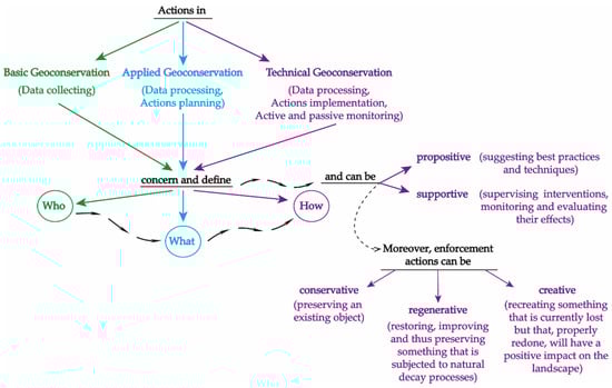
Figure 14.
Comparison between actions in the different fields of geoconservation and main objectives of Technical Geoconservation.
Geoconservation actions in the study area have been implemented by analyzing the best practices for (i) stabilizing and reinforcing the conglomeratic walls on which the ghost town stands and (ii) stabilizing and securing the sites where the remains of the slope stabilization works are visible. Concerning the former, the possibility of employing mixed reinforcement and conservation techniques has being analyzed. The purpose is to safely use the routes in the lower part of the conglomeratic walls as tourist and educational itineraries. The conglomerates are characterized by medium–high cementation and are affected by steeply dipping faults and fractures striking from the N-S to NNE-SSW. The orientation and intersection of this fracture network generates small-to-medium-sized blocks, potentially subject to falling. The clasts constituting the conglomerate rarely fall; their detachment is more due to a result of the presence of local circulating water, which compromises and decreases the cementation of the rocky mass. The proposed geoconservation technique is the combined use of reinforcement techniques with metal meshes (rockfall netting) and transparent consolidating resins, following the procedure indicated below: (1) carrying out a detailed survey at eye level and of the entire slope using a drone for data gathering (3D laser scanner); (2) data processing to identify and delimit the areas where observations can be made at eye level and to identify critical issues along the slope (isolated blocks, water infiltrations, open fractures); (3) making the slope safe by detaching any dangerous blocks, eliminating or reducing infiltrations, evaluating whether to fill open fractures; (4) placing rockfall netting (mesh 8 × 10 cm), excluding the areas previously identified; (5) consolidating the selected areas with transparent consolidating resins in order to create a single block that does not compromise slope stability. Concerning the remains of the slope stabilization works, two separate aspects were analyzed: (i) the stabilization of the sites and (ii) their safety for hiking purposes. Although slow, the slope’s natural evolution can affect the stability and conservation of the sites. As evidenced by (53), a DGSD affects the slope. Although substantial stabilization measures can be implemented, not least to ensure the conservation of the part of the ghost town in the immediate vicinity of the landslide, basic mitigation works, such as the regimentation of surface water and the implementation of localized stabilization with naturalistic engineering techniques, can be proposed. As regards the security of access to the site, the current route is freely accessible, unpaved, free of signs and protections; it was proposed (i) to secure the current route, (ii) the creation of safe observation points equipped with explanatory panels, and (iii) the placing of an explanatory panel on the main road, also with safety rules for access to the site.
7. Discussion and Conclusions
Topics concerning geological heritage management and conservation represent particularly stimulating subjects for scientific discussion. Their complexity emerges when there is an attempt to theoretically schematize approaches and procedures and to test the practical application of the hypotheses. This paper concerns a step-by-step procedure, in which the steps are an ideal itinerary revolving and moving around the central role represented by the geological context. It begins with the answer to “Why?” and the definition of Who?”, proceeds with the proposal of “What to do?”, and it ends with the answer to “How to do it?”. These steps can applied to other contexts through proper remodeling and integration. As regards the geology field, this approach allowed us to provide a procedure, to gather data, to analyze it, and to study how to properly render it for geoconservation purposes for an object or an area. The ghost town of Craco was used as a test site, as it is emblematic of many other abandoned towns surveyed in the BEGIN project. The developed tables could be useful for surveying and cataloging other similar situations of abandoned inhabited centers.
Step 00—Why? It concerns the definition and delimitation of the study area, and it concerns the justification for the choice. Regarding the reason for selection, an area that is highly recognized for its scientific/cultural/aesthetic value has the same value /importance as a less recognized or not recognized one. The planning of conservation actions should not be affected by awareness; the expected outcomes in terms of valorization, protection, conservation, and sustainability can be decisive and incisive, regardless of the location’s reputation. The reasons for choosing an area can be both geological and non-geological. The delimitation of the area to be studied should be carried out exclusively on a physical geographical basis, taking into account the catchment basin (one or more) present. Any object contained in the study area, geological or not, is linked to the evolution of the catchment basin in which it is included. Discussing global climate changes on a large scale, without worrying about the landslide that is going to involve an object or the effect that the local accumulation of pollutants can have on environmental systems (biotic and abiotic), is reductive. Craco and its surroundings have been chosen as a study area due to the presence of elements of geological, biological, and anthropological interest, the availability of bibliographical material, the notoriety of the place, and the possibility of linking together different cultural contexts along educational and tourist paths.
Step 01—Who? It concerns the definition of: (i) the PL in which the study area is inserted and its biotic and abiotic components; (ii) the basic description of all geo and non-geo elements that play a role in the area’s evolution; (iii) the description of those elements that have importance for (a) scientific research, (b) the dissemination (didactical and/or touristic) of science issues, (c) an increase in social awareness of the issues of environmental protection and geoconservation, and (iv) the description of those elements that need geoconservation actions (material or virtual) The analyzed area is well known from the stratigraphic, structural, geomorphological, and applied geological point of view, as evidenced by the available bibliography. In particular, the extensive landslide movement that led to the abandonment of the town of Craco has been the subject of detailed studies, and currently, the remains of the stabilization works that have occurred over time represent a witness of the procedures and techniques used. The morphological, geological, and historical cultural scenarios observable are suitable for the preparation of educational and tourist paths. The current state of places and objects reflects the conditions of a dynamically changing landscape. The ridge on which stands the ghost town of Craco represents a watershed articulated surface, which allows you to recognize the presence of three separate catchment basins. These basins are characterized by different gradients of relief that, in the same lithological context, can generate changes with different speeds and timing.
Step 02—What to do? Once the components and objects have been defined, the next question is how to use the available data, i.e., “What to do?” Four possible macro-areas in which the data can be used have been identified: Scientific Research; Administrative; Educational; Tourism. The Scientific Research macro-area represents the main area, the one from which the actions for the other areas branch out. Scientific Research actions are dedicated both to (i) Scientific Research s.s. and to (ii) support actions in other fields, through studies and actions designed for the needs of the final several users The main objective (i) is to (a) define and catalog the heritage, (b) create basic and applied research topics related to the heritage, (c) create relational databases, and (d) share the results with the scientific community. Support actions in other areas (ii) may seem to be a secondary objective, but they are no less important. Actions concerning (a) territorial and heritage management, (b) territorial planning, (c) territorial and heritage protection, as well as actions concerning (d) scientific and environmental education and (e) sustainable tourism, rely on scientific data to be effective and long-lasting. In the analyzed area, data related to (i) the current environmental conditions, (ii) the objects that may be the subject of management and geoconservation actions, (iii) possible educational projects, and (iv) the tourism perspective, have been implemented, so that the local administration can evaluate and plan any necessary interventions.
Step 03—How to do it? Technical support is required during the design, implementation, and time-monitoring phases, after identifying objects or areas that need geoconservation actions. A technical support in which the geo component has a strong value. A technical support that does not concern the implementation of the interventions, but rather (i) the motivations behind their proposal, their compatibility with current environmental conditions, their possible spatial–temporal evolution; (ii) the expected results and their environmental compatibility and sustainability, as well as their possible space–time evolution; and (iii) the time-monitoring of environmental geomatrices. Technical support may be propositive and/or supportive, and the proposed actions may be conservative and/or regenerative and/or creative. The technical support in the analyzed area was a propositive one, advocating the use of mixed techniques for the reinforcement, consolidation, and safety of certain areas (conservative actions). As regards the sites where the remains of the slope stabilization work are visible, two separate aspects were analyzed: (i) the stabilization of the sites and (ii) their safety for hiking purposes. For the former, interventions of superficial water regulation and local stabilization interventions, through the use of naturalistic engineering techniques, were proposed. Regarding safety, it was proposed to secure the current route and to create safe observation points equipped with explanatory panels.
Geoconservation actions can be dedicated to (i) the physical conservation of an object or an area, as well as to (ii) how to use it to enhance and disseminate itself (object or area) and the related geological topics, and to (iii) how to use it as a linking tool to other topics. In Italy, the number of students enrolling in geological sciences degree courses and scientific degrees courses in general is gradually decreasing. This phenomenon may be related to an improper “setting and introduction” of scientific subjects in schools as well. Sites and places where the conservation of the environment and its components is carried out may represent an opportunity for dissemination in the educational field, differentiating content according to different levels of education as well. In this case, the geo context should not be described as an independent topic, but rather as an integrant part of a wider cultural context. In a cultural growth path, no matter whether it is personal, educational, or touristic, the geological context and related topics may act as a hub to improve knowledge and awareness of the environment we live in, its evolutionary dynamics, and potential and critical issues. Knowledge and awareness that form the basis of a proper approach to the environment we live in and of which we are an integral part, and that should be part of everyone’s basic cultural background.
Author Contributions
Conceptualization, M.B., E.P. and S.I.G.; methodology, M.B., E.P. and S.I.G.; software, E.P.; validation, M.B., E.P., M.P., F.T.G., N.M. and S.I.G.; formal analysis, M.B., E.P., M.P., F.T.G., N.M. and S.I.G.; investigation, M.B., E.P., F.T.G., N.M. and S.I.G.; resources, M.B. and S.I.G.; data curation, M.B., E.P., M.P., F.T.G., N.M. and S.I.G.; writing—original draft preparation, M.B., E.P., M.P., F.T.G., N.M. and S.I.G.; writing—review and editing, E.P. and S.I.G.; visualization, E.P. and S.I.G.; supervision, M.B., E.P., F.T.G., N.M. and S.I.G.; project administration, M.B. and F.T.G.; funding acquisition, M.B. All authors have read and agreed to the published version of the manuscript.
Funding
This research was funded by the BEGIN Project, POR FESR Basilicata 2014–2020, granted to Prof. M. Bentivenga.
Institutional Review Board Statement
Not applicable.
Informed Consent Statement
Not applicable.
Data Availability Statement
Data are contained within the article.
Conflicts of Interest
The authors declare no conflicts of interest.
Appendix A
Table A1.
Main cultural contexts that can be developed in the study area. In green, the contexts discussed in this paper are highlighted. Codes and acronyms are functional to the realization of a relational database.
Table A1.
Main cultural contexts that can be developed in the study area. In green, the contexts discussed in this paper are highlighted. Codes and acronyms are functional to the realization of a relational database.
| Cultural Contexts | ||||||||
|---|---|---|---|---|---|---|---|---|
| Code | Context | Acronym | Code | Context | Acronym | Code | Context | Acronym |
| 01 | Geology | Geol | 07 | Culture (Generic) | GenCul | 13 | Religion | Rel |
| 02 | Biology | Biol | 08 | Anthropic building | Anth | 14 | Health | Heal |
| 03 | History | Hist | 09 | Environment | Env | 15 | ----- | ----- |
| 04 | Administrative | Adm | 10 | Hazard | Haz | |||
| 05 | Educational | Edu | 11 | Folklore | Folk | |||
| 06 | Touristic | Tur | 12 | Museum | Mus | |||
Table A2.
Available bibliography. In green, geological papers (and in brown, non-geological available papers) are presented.
Table A2.
Available bibliography. In green, geological papers (and in brown, non-geological available papers) are presented.
| 1 | Cotecchia V. (1959) Il dissesto idrogeologico nella Provincia di Matera. Annali della Facoltà di Ingegneria (Bari) 3:363–388. |
| 2 | Brugner W. (1964)—Sulle condizioni di stabilità dell’abitato di Craco (Provincia di Matera). Servizio Geologico d’Italia, Largo S. Susanna, 13, Roma |
| 3 | Servizio Geologico d’Italia (1968)—Carta Geologica d’Italia F. 200 Tricarico della carta 1:100.000 dell’ IGM, Poligrafica & Cartevalori Ercolano (Napoli), avaiable on line at < http://sgi.isprambiente.it/geologia100k/mostra_foglio.aspx?numero_foglio=200> |
| 4 | Servizio Geologico d’Italia (1969)—Carta Geologica d’Italia F. 201 Matera della carta 1:100.000 dell’ IGM, Litografia Artistica Cartogafica Firenze, avaiable on line at < http://sgi.isprambiente.it/geologia100k/mostra_foglio.aspx?numero_foglio=201> |
| 5 | Ogniben L. (1969)—Schema introduttivo della geologia del confine calabro-lucano, Mem. Soc. Geol. It, 8, 453–763 |
| 6 | Lentini, F. (1969). Facies e stratigrafia dei depositi pliocenici affioranti fra il F. Agri e la zona di Craco.(Matera). Atti Acc. Gioenia Sc. Nat. Catania, s. 7(1), 529–556. |
| 7 | Lentini F. (1971)—La sezione plio-pleistocenica di Pisticci sul bordo appenninico della Fossa Bradanica. Atti Acc. Gioenia Sc. Nat. Catania, s.7, 3: 109–192. |
| 8 | Boenzi F., Palmentola G. & Valduca A. (1971)—Note Illustrative della Carta Geologica d’Italia alla Scala 1:100.000 Foglio 200 Tricarico, Nuova Tecnica Grafica Roma, avaiable on line at<http://sgi.isprambiente.it/geologia100k/mostra_pdf.aspx?pdffile=200.pdf> |
| 9 | Boenzi F., Radina B., Ricchetti G. & Valduga A. (1971)—Note Illustrative della Carta Geologica d’Italia alla Scala 1:100.000 Foglio 201 Matera, Nuova Tecnica Grafica Roma, avaiable on line at < http://sgi.isprambiente.it/geologia100k/mostra_pdf.aspx?pdffile=201.pdf> |
| 10 | Pellegrino M (1972) Descrizione della frana di Craco in Lucania. Il frantoio, pp 34–41 |
| 11 | Pellegrino M, Priore E (1973) Descrizione di alcuni dissesti verificatisi in Lucania durante le recenti precipitazioni. Il frantoio XI 6:10–14 |
| 12 | Del Prete M, Petley DJ (1982) Case history of the main landslide at Craco, Basilicata, South Italy. Geol Appl Idrogeol 17:291–304 |
| 13 | Del Prete M (1990) La difesa dei Centri Storici minacciati dalle frane: Craco un’esperienza da non ripetere. Sc Dir. Econ. Amb. 7–8:39–41 |
| 14 | Pedio T (1990) Centri scomparsi in Basilicata. Osanna Edizioni, Venosa |
| 15 | Lazzari S. & Lentini F. (1991)—Carta Geologica del Bacino del Fiume Agri. Scala 1:50.000, S.EL.CA. (Ed.),Firenze. |
| 16 | Pieri P., Sabato L., Loiacono F. & Marino M. (1994)—Il bacino di piggyback di Sant’Arcangelo: evoluzione tettonico-sedimentaria. Boll. Soc. Geol. It., 113: 465–481. |
| 17 | Rescio P. F., 1998, Storia e architettura di Craco, in Basilicata Regione Notizie, XI/3, 93–96. |
| 18 | Bentivenga M, Coltorti M, Prosser G (2004) Il movimento gravitativo profondo di Craco (Basilicata Ionica). Il Quaternario, Italian Journal of Quaternary Sciences 17(2/2):613–625 |
| 19 | Del Monaco G, Falconi L, Margottini C, Puglisi C, Spizzichino D (2004) Integrated approach for landslide risk assessment of Craco village (Italy). In: (a cura di): Lacerda, Ehrlich, Fontoura, Sayao, Landslides: evaluation andstabilisation. Taylor & Francis, London ISBN: 9780415356657 |
| 20 | Bentivenga M, Foresi LM, Prestera A, Prosser G, Sabia M (2005) Structures located at the front of a thrust and fold belt: the Craco area (Southern Apennines, Italy). Boll Soc Geol Ital 124(2):367–376 |
| 21 | Delmonaco, G., Falconi, L., Leoni, G., Margottini, C., Puglisi, C., & Spizzichino, D. (2005). Multi-temporal and quantitative geomorphological analysis on the large landslide of Craco Village. In K. Sassa, H. ter management (vol. 2. pp. 113–117). Berlin Heidelberg: Springer-Verlag. ISBN/ISSN: 978-3-540-28664-6, 10.1007/3-540-28680-2_13. |
| 22 | Masini N. (2006). Dai Normanni agli Angioini: castelli e fortificazioni della Basilicata. In: Storia della Basilicata. Il Medioevo, a cura di Fonseca C. D., 689–753, Editori Laterza |
| 23 | Prosser, G., Bentivenga, M., Laurenzi, M., Caggianelli, A., Dellino, P., & Doronzo, D. (2008). Late Pliocene volcaniclastic products from Southern Apennines: Distal witness of early explosive volcanism in the central Tyrrhenian Sea. Geological Magazine, 145(4), 521–536. doi:10.1017/S0016756808004512 |
| 24 | Papallo O., Bianco P.M., 2012. Carta della Natura della Regione Basilicata: Carta degli habitat alla scala 1:50.000. ISPRA, <https://www.isprambiente.gov.it/it/servizi/sistema-carta-della-natura/cartografia/carta-della-natura-alla-scala-1-50.000/basilicata> |
| 25 | Angelucci F, Domenici F, Ricci S (2013) Prime acquisizioni sull’abitato e la torre normanna di Craco (Matera). In E. De Minicis (a cura di) Case e torri medievali IV—Indagini sui centri dell’Italia Meridionale e insulare (sec. XI-XV) Campania, Basilicata, Puglia, Calabria, Sicilia e Sardegna. Atti del V Convegno Nazionale di Studi (Orte, 15–16 Marzo 2013), 81–106 |
| 26 | ISPRA (2014)—Progetto CARG Nuova Cartografia Geologica alla scala 1:50.000 F 507 Pisticci https://www.isprambiente.gov.it/Media/carg/507_PISTICCI/Foglio.html |
| 27 | De Cadilhac, R. (2014) The Norman tower in the abandoned village of Craco (MT). Meaning and reasons of the restoration. Key Engineering Materials, Volume 628, Pages 34—392014 International Conference on Historical Centres among Culture, Art and Techniques: A New Paradigma for Risks Prevention Through Structural Monitoring, SMART BUILT 201427 March 2014through 29 March 2014Code 107497. DOI: 10.4028/www.scientific.net/KEM.628.34. |
| 28 | ISPRA (2015)—Progetto CARG Nuova Cartografia Geologica alla scala 1:50.000 Note Illustrative del F 507 Pisticci, a cura di Carbone S., Lentini F., https://www.isprambiente.gov.it/Media/carg/note_illustrative/507_Pisticci.pdf |
| 29 | Bentivenga, M., Capolongo, D., Palladino, G., & Piccarreta, M. (2015). Geomorphological map of the area between Craco and Pisticci (Basilicata, Italy). Journal of Maps, 11 (2), 267–277. doi:10.1080/17445647.2014,935501 |
| 30 | Pirlone F (2016) I borghi antichi abbandonati. Patrimonio da riscoprire e mettere in sicurezza. Franco Angeli Editore, Milan ISBN 9788891740588 |
| 31 | Doronzo, D.M., Caggianelli, A. & Dellino, P. A ghost eruption behind “Le vulcanoclastiti di Craco” ghost town, Basilicata, Italy. Int J Earth Sci (Geol Rundsch) 108, 545–546 (2019). https://doi.org/10.1007/s00531-018-1665-z |
| 32 | Gizzi F.T., Bentivenga M., Lasaponara R., Danese M., Potenza M.R., Sileo M. & Masini N. (2019)—Natural Hazards, Human Factors, and “Ghost Towns”: a Multi-Level Approach, Geoheritage, 11, 1533–1565. |
| 33 | Lerna, M., Sabbà, M. F. Diaferio, M.; Carnimeo, L., Ivorra, S.; Foti, D. (2020) Seismic risk assessment of a medieval tower: The case study of Craco Proceedings of the International Conference on Structural Dynamic, EURODYNVolume 2, Pages 4911—4921202011th International Conference on Structural Dynamics, EURODYN 2020Virtual, Athens 23 November 2020through 26 November 2020Code 165382 |
| 34 | D’Agostino, A.; Cerreta, M.; Vannelli, G.; Zizzania, P. (2020) A way for the italian inner area montagna materana rethink the abandonment from craco. Sustainable Mediterranean Construction, Volume 2020, Issue 4 Special Issue, Pages 69—732020 |
| 35 | De Cadilhac, R., Catella, M.A. (2020) Craco, a medieval village. The re-invention of places throughout new forms of anthropization and museum display | Il borgo medievale di Craco: la reinvenzione dei luoghi tra nuove forme di antropizzazione e musealizzazione. ArcHistoR, 2020, 13(7), pp. 1243–1267 |
| 36 | De Cadilhac, R, Catella, M.A. (2022) Il borgo medievale di Craco: la “reinvenzione dei luoghi” tra nuove forme di antropizzazione e musealizzazione. ARCHISTOR-ARCHITECTURE HISTORY RESTORATION (13), pp. 1242–1267 |
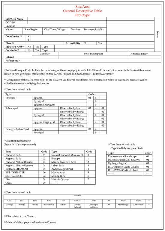
Figure A1.
Prototype of the Site/Area General Descriptive Table.
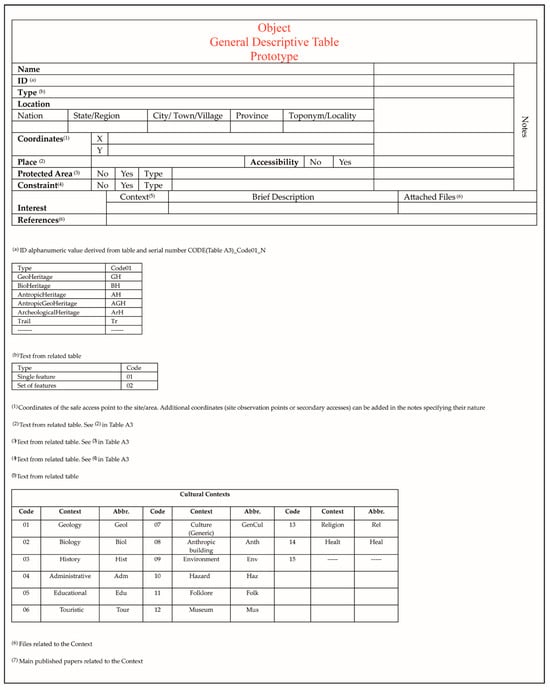
Figure A2.
Prototype of the Object General Descriptive Table.
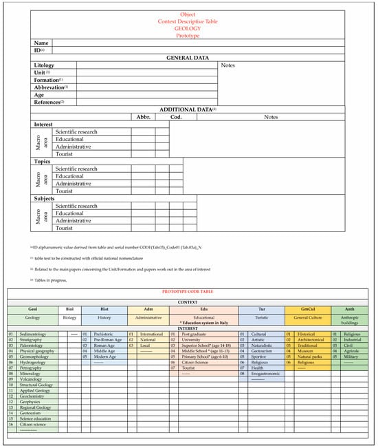
Figure A3.
Prototype of the Object Descriptive Table for the Context Geology.
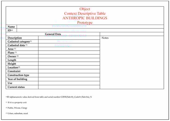
Figure A4.
Prototype of the Object Descriptive Table for the Context Anthropic Buildings.
Table A3.
Organization of available bibliography by keywords (KW). The green color refers to papers related to the geo context.
Table A3.
Organization of available bibliography by keywords (KW). The green color refers to papers related to the geo context.
| ID | KW01 | KW02 | KW03 | KW04 | KW05 |
|---|---|---|---|---|---|
| 1 | Geo | Applied Geology | Hydrogeological disturbance | ITA_S | L |
| 2 | Geo | Applied Geology | Hydrogeological disturbance | ITA_S | L |
| 3 | Geo | Geological map | Geological Map of Italy at 1:100.000 scale | ITA_S | R |
| 4 | Geo | Geological map | Geological Map of Italy at 1:100.000 scale | ITA_S | R |
| 5 | Geo | Regional geology | Stratigraphy | ITA_S | R |
| 6 | Geo | Stratigraphy | Pliocene deposits | ITA_S | R |
| 7 | Geo | Stratigraphy | Pliocene and Pleistocene deposits | ITA_S | R |
| 8 | Geo | Text related to Geological map | Geological Map of Italy at 1:100.000 scale | ITA_S | R |
| 9 | Geo | Text related to Geological map | Geological Map of Italy at 1:100.000 scale | ITA_S | R |
| 10 | Geo | Applied Geology | Hydrogeological instability | ITA_S | L |
| 11 | Geo | Applied Geology | Hydrogeological instability | ITA_S | R |
| 12 | Geo | Applied Geology | Hydrogeological instability | ITA_S | L |
| 13 | Geo | Applied Geology | Hydrogeological instability | ITA_S | L |
| 14 | Hist | Ghost Town | ITA_S | R | |
| 15 | Geo | Geological mapping | Geological Map at 1:50.000 scale | ITA_S | R |
| 16 | Geo | Regional geology | Pliocene and Pleistocene deposits | ITA_S | R |
| 17 | Hist | Ghost Town | Southern Italy | ITA_S | L |
| 18 | Geo | Applied Geology | Hydrogeological instability | ITA_S | L |
| 19 | Geo | Applied Geology | Hydrogeological instability | ITA_S | L |
| 20 | Geo | Structural Geology | Regional geology | ITA_S | L |
Table A4.
Research topics that can be developed in the study area.
Table A4.
Research topics that can be developed in the study area.
| Topic | Subject | |
|---|---|---|
| Geology | Pliocene to Pleistocene basins | Depositional sequences |
| in the southern Apennine area | Tectonics and sedimentation | |
| Evolution and possible correlation between different Pliocene to Pleistocene basins in southern Apennines | ||
| Structural analysis and definition of palaeostress in Pliocene and Pleistocene conglomerate deposits | ||
| Evolution, comparison, and correlation between analogous basins in central/northern Italy | ||
| Evolution, comparison, and correlation between analogous basins in extra Italy contexts | ||
| Evolution and comparison between basins in different geodynamic contexts in the Pliocene–Pleistocene interval | ||
| ------ | ||
| Geomorphology | Morphometry | Evolution of the main river basin and sub-basins |
| Estimation of uplift rates | ||
| Genesis and evolution of river terraces | ||
| Automatic extraction of shapes and comparison with theoretical evolutionary models | ||
| ------ | ||
| Slopes evolution | Differential erosion | |
| Rockslide | ||
| Lateral spread | ||
| DGSD | ||
| Badlands | ||
| Soil erosion rates and modes | ||
| ------ | ||
| Applied geology | Stabilization techniques of slopes |
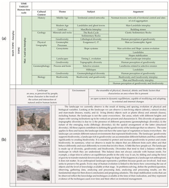
Figure A5.
Applied and Popularizing Geoconservation. Educational macro-area. (a) Arguments developed in the study area. (b) Basic text to be developed for students of different age groups.
References
- Sharples, C. Concepts and Principles of Geoconservation; Park and Wildlife Service, Department of Environment and Land Management: Tasmania, Australia, 1998; p. 86.
- Brilha, J. Geoconservation and protected areas. Environ. Conserv. 2002, 29, 273–276. [Google Scholar] [CrossRef]
- Brocx, M.; Semeniuk, V. Geoheritage and geoconservation: History, definition, scope and scale. J. R. Soc. West. Aust. 2007, 90, 53–87. [Google Scholar]
- Brocx, M.; Semeniuk, V. The “8Gs”—A blueprint for Geoheritage, Geoconservation, Geo-education and Geotourism. Aust. J. Earth Sci. 2019, 66, 803–821. [Google Scholar] [CrossRef]
- Burek, C.V.; Prosser, C.D. (Eds.) The History of Geoconservation; The Geological Society of London: London, UK, 2008; Volume 300, pp. 1–312. [Google Scholar]
- Brocx, M. Geoheritage: From Global Perspectives to Local Principles for Conservation and Planning; Western Australian Museum: Perth, WA, Australia, 2008; p. 175. ISBN 9781920843359. [Google Scholar]
- ProGEO. Conserving Our Shared Geoheritage: A Protocol on Geoconservation Principles, Sustainable Site Use, Management, Fieldwork, Fossil and Mineral Collecting 2011. pp. 1–10. Available online: http://www.progeo.se/progeo-protocol-definitions-20110915 (accessed on 30 January 2023).
- Brilha, J.; Gray, M.; Pereira, D.I.; Pereira, P. Geodiversity: An integrative review as a contribution to the sustainable management of the whole of nature. Environ. Sci. Policy 2018, 86, 19–28. [Google Scholar] [CrossRef]
- Reynard, E.; Brilha, J. (Eds.) Geoheritage: Assessment, Protection, and Management; Elsevier: Amsterdam, The Netherland, 2018. [Google Scholar]
- Crofts, R.; Gordon, J.E.; Brilha, J.; Gray, M.; Gunn, J.; Larwood, J.; Santucci, V.L.; Tormey, D.; Worboys, G.L. Guidelines for Geoconservation in Protected and Conserved Areas; Series No. 31; Best Practice Protected Area Guidelines, IUCN: Gland, Switzerland, 2020. [Google Scholar]
- Sharples, C. A Methodology for the Identification of Significant Landforms and Geological Sites for Geoconservation Purposes; Report to Forestry Commision: Tasmania, Australia, 1993; pp. 1–31.
- Wilson, C. (Ed.) Earth Heritage Conservation; Geological Society London & Open University: Milton Keynes, UK, 1994; pp. 1–272. [Google Scholar]
- Cowie, J.W.; Wimbledon, W.A.P. The World Heritage list and its relevance to geology. In Geological and Landscape Conservation; O’Halloran, D., Green, C., Harley, M., Stanley, M., Knill, J., Eds.; Geological Society of London: London, UK, 1994; pp. 71–73. [Google Scholar]
- Duff, K.L. Natural Areas: An holistic approach to conservation based on geology. In Geological and Landscape Conservation, London; O’Halloran, D., Green, C., Harley, M., Stanley, M., Knill, J., Eds.; Geological Society of London: London, UK, 1994; pp. 121–126. [Google Scholar]
- Dixon, G. Geoconservation: An International Review and Strategy for Tasmania; Occasional Paper No. 35; Parks & Wildlife Service: Tasmania, Australia, 1996; pp. 1–126.
- Wimbledon, W.A.P. Geosites—A new conservation initiative. Episodes 1996, 19, 87–88. [Google Scholar] [CrossRef]
- Benvenuti, M.; Boni, M.; Brancucci, G.; Bortolami, G.; Burlando, M.; Costantini, E.; D’Andrea, M.; Gisotti, G.; Guado, G.; Marchetti, M.; et al. The conservation of geological heritage in Italy: State of the art and future perspectives of the “GEOSITES” project. Geol. Balc. 1998, 28, 117–123. [Google Scholar]
- Cleal, C.J.; Thomas, B.A.; Bevins, R.E.; Wimbledon, W.A.P. GEOSITES: An international geoconservation initiative. Geol. Today 1999, 15, 64–68. [Google Scholar] [CrossRef]
- Stanley, M. Geodiversity. Earth Herit. 2000, 14, 15–18. [Google Scholar]
- Stanley, M. Geodiversity—Linking People, Landscapes and Their Culture. Abstract for Natural And Cultural Landscapes Conference; Royal Irish Academy: Dublin, Ireland, 2002; pp. 45–52. [Google Scholar]
- Reynard, E. Geosite. In Encyclopedia of Geomorphology; Goudie, A., Ed.; Routledge: London, UK, 2004; p. 440. [Google Scholar]
- Gray, M. Geodiversity Valuing and Conserving Abiotic Nature; John Wiley & Sons Ltd.: Chichester, UK, 2004; pp. 1–434. [Google Scholar]
- Bruschi, V.M.; Cendrero, A. Geosite evaluation; can we measure intangible values? Il Quat. 2005, 18, 293–306. [Google Scholar]
- Carton, A.; Coratza, P.; Marchetti, M. Guidelines for geomorphological sites mapping: Examples from Italy. Géomorphologie Relief Process. Environ. 2005, 11, 209–218. [Google Scholar] [CrossRef]
- Carton, A.; Seppi, A.; Zucca, F.; Pellgrini, L.; Boni, P. “Pre-geosite” bibliography: A proposal of exploitation. Il Quat. 2005, 18, 15–21. [Google Scholar]
- Coratza, P.; Giusti, C. Methodological proposal for the assessment of the scientific quality of geomorphosites. Il Quat. 2005, 18, 307–313. [Google Scholar]
- Piacente, S. Geosites and Geodiversity for a cultural approach to Geology. Il Quat. 2005, 18, 11–14. [Google Scholar]
- Reynard, E.; Panizza, M. Géomorphosites: Définition, évaluation et cartographie. Une introduction. Géomorphologie Relief Process. Environ. 2005, 11, 177–180. [Google Scholar] [CrossRef]
- Reynard, E. Geomorphosites: Definitions and characteristics. In Geomorphosites; Reynard, E., Coratza, P., Regolini-Bissig, G., Eds.; Verlag Dr. Friedrich Pfeil: München, Germany, 2009; pp. 9–20. [Google Scholar]
- Bollati, I.; Coratza, P.; Giardino, M.; Laureti, L.; Leonelli, G.; Panizza, M.; Panizza, V.; Pelfini, M.; Piacente, S.; Pica, A.; et al. Directions in Geoheritage Studies: Suggestions from the Italian Geomorphological Community. In Engineering Geology for Society and Territory; Lollino, G., Giordan, D., Marunteanu, C., Christaras, B., Yoshinori, I., Margottini, C., Eds.; Springer: Berlin/Heidelberg, Germany, 2015; Volume 8, pp. 213–217. [Google Scholar] [CrossRef]
- Crofts, R.; Gordon, J.E. Geoconservation in protected areas. In Protected Area Governance and Management; Worboys, G.L., Lockwood, M., Kothari, A., Feary, S., Pulsford, I., Eds.; ANU Press: Canberra, Australia, 2015; pp. 531–568. [Google Scholar]
- Brilha, J. Inventory and Quantitative Assessment of Geosites and Geodiversity Sites: A Review. Geoheritage 2016, 8, 119–134. [Google Scholar] [CrossRef]
- Brilha, J.; Reynard, E. Geoheritage and Geoconservation: The Challenges. In Geoheritage: Assessment, Protection, and Management; Reynard, E., Brilha, J., Eds.; Elsevier: Amsterdam, The Netherlands, 2018; pp. 433–438. [Google Scholar]
- Gray, M. Geodiversity: The backbone of geoheritage and geo-conservation. In Geoheritage: Assessment, Protection, and Management; Reynard, E., Brilha, J., Eds.; Elsevier: Amsterdam, The Netherlands, 2018; pp. 13–25. [Google Scholar]
- Boukhchim, N.; Fraj, T.B.; Reynard, E. Lateral and “Vertico-Lateral” Cave Dwellings in Haddej and Guermessa: Characteristic Geocultural Heritage of Southeast Tunisia. Geoheritage 2018, 10, 575–590. [Google Scholar] [CrossRef]
- Gordon, J.E. Geoconservation principles and protected area management. Int. J. Geoheritage Parks 2019, 7, 199–210. [Google Scholar] [CrossRef]
- Pasquaré Mariotto, F.; Drymoni, K.; Bonali, F.; Tibaldi, A.; Corti, N.; Oppizzi, P. Geosite Assessment and Communication: A Review. Resources 2023, 12, 29. [Google Scholar] [CrossRef]
- Pasquaré Mariotto, F.; Bonali, F.L. Virtual Geosites as Innovative Tools for Geoheritage Popularization: A Case Study from Eastern Iceland. Geosciences 2012, 11, 149. [Google Scholar] [CrossRef]
- Pescatore, E.; Bentivenga, M.; Giano, S.I. Geoheritage and Geoconservation: Some Remarks and Considerations. Sustainability 2023, 15, 5823. [Google Scholar] [CrossRef]
- Hose, T. Selling the Story of Britain’s Stone. Environ. Interpret. 1995, 10, 16–17. [Google Scholar]
- Hose, T.A. Geotourism—Selling the earth to Europe. In Engineering Geology and the Environment; Marinos, P.G., Koukis, G.C., Tsiambaos, G.C., Stournas, G.C., Eds.; A.A. Balkema: Rotterdam, Netherlands, 1997; Volume 3, pp. 2955–2960. [Google Scholar]
- Hose, T.A. Geo-tourism appreciating the deep time of landscapes. In Niche Tourism: Contemporary Issues, Trends and Cases; Novelli, M., Ed.; Elsevier: London, UK, 2005; pp. 27–37. [Google Scholar]
- Hose, T.A. Towards a history of geotourism: Definitions, antecedents and the future. In The History of Geoconservation; Burek, C.V., Prosser, C.D., Eds.; Geological Society Special Publication No. 300; Geological Society: London, UK, 2008; pp. 37–60. [Google Scholar]
- Pica, A.; Vergari, F.; Fredi, P.; Del Monte, M. The Aeterna Urbs geomorphological heritage (Rome, Italy). Geoheritage 2015, 8, 31–42. [Google Scholar] [CrossRef]
- Brocx, M.; Semeniuk, V. Building Stones Can Be of Geoheritage Significance. Geoheritage 2019, 11, 133–149. [Google Scholar] [CrossRef]
- Kubalíková, L.; Drápela, E.; Kirchner, K.; Bajer, A.; Balková, M.; Kuda, F. Urban geotourism development and geoconservation: Is it possible to find a balance? Environ. Sci. Policy 2021, 121, 1–10. [Google Scholar] [CrossRef]
- Gray, M. Geodiversity, geoheritage and geoconservation for society. Int. J. Geoheritage Parks 2018, 7, 226–236. [Google Scholar] [CrossRef]
- Dowling, R.K.; Newsome, D. (Eds.) Geotourism; Elsevier Butterworth-Heinemann: Amsterdam, The Netherland, 2006; p. 260. [Google Scholar]
- Newsome, D.; Dowling, R.K. Geotourism: The Tourism of Geology and Landscape; Goodfellow Publishers: Oxford, UK, 2010. [Google Scholar] [CrossRef]
- Taylor, K.; Lennon, J. Cultural landscapes: A bridge between culture and nature. Int. J. Herit. Stud. 2011, 17, 537–554. [Google Scholar] [CrossRef]
- Reynard, E.; Pica, A.; Coratza, P. Urban geomorphological heritage. An Overview. Quaest. Geogr. 2017, 36, 7–20. [Google Scholar] [CrossRef]
- Gordon, J.E. Geoheritage, geotourism and the cultural landscape: Enhancing the visitor experience and promoting geoconservation. Geosciences 2018, 8, 136. [Google Scholar] [CrossRef]
- Reynard, E.; Giusti, C. The landscape and the cultural value of geoheritage. In Geoheritage: Assessment, Protection, and Management; Reynard, E., Brilha, J., Eds.; Elsevier: Amsterdam, The Netherlands, 2018; pp. 147–166. [Google Scholar]
- Olson, K.; Dowling, R. Geotourism and cultural heritage. Geoconserv. Res. 2018, 1, 37–41. [Google Scholar]
- Pijet-Migon, E.; Migon, P. Geoheritage and Cultural Heritage A Review of Recurrent and Interlinked Themes. Geosciences 2022, 12, 98. [Google Scholar] [CrossRef]
- Hooke, R. On the history of human as geomorphic agents. Geology 2000, 28, 843–846. [Google Scholar] [CrossRef]
- Panizza, M.; Piacente, S. Geomorfologia Culturale; Pitagora Editrice Bologna: Bologna, Italy, 2003; p. 350. [Google Scholar]
- Wilkinson, B.H. Humans as geologic agents: A deep-time perspective. Geology 2005, 33, 161–164. [Google Scholar] [CrossRef]
- Goudie, A. The Human Impact on the Environment, 6th ed.; Blackwell: Oxford, UK, 2007. [Google Scholar]
- Pescatore, E.; Bentivenga, M.; Giano, S.I.; Siervo, V. Geomorphosites: Versatile Tools in Geoheritage Cultural Dissemination. Geoheritage 2019, 11, 1583–1601. [Google Scholar] [CrossRef]
- Coratza, P.; Bollati, I.M.; Panizza, V.; Brandolini, P.; Castaldini, D.; Cucchi, F.; Deiana, G.; Del Monte, M.; Faccini, F.; Finocchiaro, F.; et al. Advances in Geoheritage Mapping: Application to Iconic Geomorphological Examples from the Italian Landscape. Sustainability 2021, 13, 11538. [Google Scholar] [CrossRef]
- Angelucci, F.; Domenici, F.; Ricci, S. Prime acquisizioni sull’abitato e la torre normanna di Craco (Matera). In Case e torri Medievali IV—Indagini Sui Centri dell’Italia Meridionale e Insulare (sec. XI-XV) Campania, Basilicata, Puglia, Calabria, Sicilia e Sardegna; De Minicis, E., Ed.; Atti del V Convegno Nazionale di Studi: Orte, Italy, 2013; pp. 81–106. [Google Scholar]
- Rescio, P.F. Storia e architettura di Craco. In Basilicata Regione Notizie; Consiglio Regionale della Basilicata: Potenza, Italy, 1998; Volume 3, pp. 93–96. [Google Scholar]
- Masini, N. Dai Normanni agli Angioini: Castelli e fortificazioni della Basilicata. In Storia della Basilicata. Il Medioevo; Fonseca, C.D., Ed.; Editori Laterza: Roma-Bari, Italy, 2006; pp. 689–753. [Google Scholar]
- Gizzi, F.T.; Bentivenga, M.; Lasaponara, R.; Danese, M.; Potenza, M.R.; Sileo, M.; Masini, N. Natural Hazards, Human Factors, and “Ghost Towns”: A Multi-Level Approach. Geoheritage 2019, 433–464. [Google Scholar] [CrossRef]
- Balduzzi, A.; Casnedi, R.; Crescenti, U.; Tonna, M. Il Plio-Pleistocene nel sottosuolo del bacino pugliese (Avanfossa Appenninica). Geol. Romana 1982, 21, 1–28. [Google Scholar]
- Sella, M.; Turci, C.; Riva, A. Sintesi geopetrolifera della Fossa Bradanica (Avanfossa della catena Appenninica). Mem. Soc. Geol. It. 1988, 41, 87–107. [Google Scholar]
- Beneduce, P.; Giano, S.I. Osservazioni preliminari sull’assetto morfostrutturale dell’edificio vulcanico del Monte Vulture (Basilicata). Il Quat. 1996, 9, 325–330. [Google Scholar]
- Pieri, P.; Sabato, L.; Tropeano, M. Significato geodinamico dei caratteri deposizionali e strutturali della Fossa Bradanica nel Pleistocene. Mem. Soc. Geol. It. 1996, 51, 501–515. [Google Scholar]
- Bentivenga, M.; Foresi, L.M.; Prestera, A.; Prosser, G.; Sabia, M. Structures located at the front of a thrust and fold belt: The Craco area (Southern Apennines, Italy). Boll. Soc. Geol. Ital. 2005, 124, 367–376. [Google Scholar]
- Pescatore, T.S. La sedimentazione miocenica nell’Appennino Campano Lucano. Mem. Soc. Geol. It. 1988, 41, 37–46. [Google Scholar]
- Lazzari, S.; Lentini, F. Carta Geologica del Bacino dell’Agri alla scala 1:50.000. Note illustrative del F. 507 Pisticci. Reg. Basilicata 1980, 55. [Google Scholar]
- Carbone, S.; Catalano, S.; Lazzari, S.; Lentini, F.; Monaco, C. Presentazione della carta geologica del bacino del Fiume Agri (Basilicata). Mem. Soc. Geol. It. 1991, 47, 129–143. [Google Scholar]
- Patacca, E.; Scandone, P. Late thrust propagation and sedimentary response in the thrust-belt-foredeep system of the Southern Apennines (Pliocene-Pleistocene). In Anatomy of an Orogen: The Apennines and Adjacent Mediterranean Basins; Vai, G.B., Martini, I.P., Eds.; Springer: Dordrecht, The Netherlands, 2001; pp. 401–440. [Google Scholar] [CrossRef]
- ISPRA Progetto CARG Nuova Cartografia Geologica Alla Scala 1:50.000 F 507 Pisticci. 2014. Available online: https://www.isprambiente.gov.it/Media/carg/507_PISTICCI/Foglio.html (accessed on 30 January 2023).
- Casero, P.; Roure, F.; Endignoux, L.; Moretti, I.; Müller, C.; Sage, L.; Vially, R. Neogene geodynamic evolution of the Southern Apennines. Mem. Soc. Geol. It. 1988, 41, 109–120. [Google Scholar]
- Roure, F.; Casero, P.; Vially, R. Growth processes and mélange formation in the Southern Apennines accretionary wedge. Earth Planet. Sci. Lett. 1991, 102, 395–412. [Google Scholar] [CrossRef]
- Prosser, G.; Bentivenga, M.; Laurenzi, M.; Caggianelli, A.; Dellino, P.; Doronzo, D. Late Pliocene volcaniclastic products from Southern Apennines: Distal witness of early explosive volcanism in the central Tyrrhenian Sea. Geol. Mag. 2008, 145, 521–536. [Google Scholar] [CrossRef]
- Papallo, O.; Bianco, P.M. Carta della Natura Della Regione Basilicata: Carta Degli Habitat Scala 1:50.000; ISPRA: Roma, Italy, 2012.
- APAT Il Progetto Carta della Natura Alla Scala 1:250.000, Metodologia di Realizzazione, Serie Manuali e Linee Guida, 17/2003. Available online: https://www.isprambiente.gov.it/contentfiles/00003500/3552-manuali-2003-17.pdf/ (accessed on 30 January 2023).
- APAT Il Progetto Carta della Natura Alla Scala 1:50.000: Metodologia di Realizzazione. Serie Manuali e Linee Guida 30/2004. Available online: https://www.isprambiente.gov.it/contentfiles/00003400/3490-mlg-30-2004-carta-della-natura.pdf (accessed on 16 March 2023).
- ISPRA l Progetto Carta della Natura Alla Scala 1:50.000—Linee Guida per la Cartografia e la Valutazione Degli Habitat. Serie Manuali e Linee Guida N. 48/2009a. Available online: https://www.isprambiente.gov.it/files/pubblicazioni/manuali-lineeguida/cartanatura_manuale_2009_48_50mila.pdf (accessed on 16 March 2023).
- ISPRA “Gli habitat in Carta Della Natura—Schede Descrittive Degli Habitat per la Cartografia Alla Scala 1:50.000”, Serie Manuali e Linee Guida N. 49/2009b. Available online: https://www.isprambiente.gov.it/files/pubblicazioni/manuali-lineeguida/cartanatura_manuale_2009_49_schedehabitat.pdf (accessed on 16 March 2023).
- Chapman, D.H. Diagnostic Criteria for Plants and Soils. BioScience 1966, 16, 365. [Google Scholar]
- Rossi, G.; Montagnani, C.; Gargano, D.; Peruzzi, L.; Abeli, T.; Ravera, S.; Cogoni, A.; Fenu, G.; Magrini, S.; Gennai, M.; et al. (Eds.) Lista Rossa della Flora Italiana. 1. Policy Species e Altre Specie Minacciate; Comitato Italiano IUCN e Ministero dell’Ambiente e della Tutela del Territorio e del Mare: Stamperia, Romana, 2013; p. 58.
- Nardi, E.; Raffaelli, M. A misknown Italian endemic species: « Polygonum tenoreanum » nom. nov. (≡P. elegans Ten.). Webbia 1977, 31, 513–527. [Google Scholar] [CrossRef]
- IRST, International Recommendations for Tourism Statistics. 2010. Available online: https://unstats.un.org/unsd/publication/Seriesm/SeriesM_83rev1e.pdf (accessed on 16 March 2023).
- IRST, International Recommendations for Tourism Statistics, Draft Compilation Guide. 2011. Available online: https://unstats.un.org/unsd/tradeserv/egts/CG/IRTS%20compilation%20guide%207%20march%202011%20-%20final.pdf (accessed on 16 March 2023).
- EUROSTAT Methodological Manual for Tourism Statistics. Version 3.1. 2014. Available online: https://ec.europa.eu/eurostat/documents/3859598/6454997/KS-GQ-14-013-EN-N.pdf/166605aa-c990-40c4-b9f7-59c297154277?t=1420557603000 (accessed on 16 March 2023).
- García-Ortiz, E.; Fuertes-Gutiérrez, I.; Fernández-Martínez, E. Concepts and terminology for the risk of degradation of geological heritage sites: Fragility and natural vulnerability, a case study. Proc. Geol. Assoc. 2014, 125, 463–479. [Google Scholar] [CrossRef]
- Selmi, L.; Canesin, T.S.; Gauci, R.; Pereira, P.; Coratza, P. Degradation Risk Assessment: Understanding the Impacts of Climate Change on Geoheritage. Sustainability 2022, 14, 4262. [Google Scholar] [CrossRef]
- Kubalikova, Lucie and Balkova, Marie, Two-Level Assessment of Threats to Geodiversity and Geoheritage: A Case Study from Hády Quarries (Brno, Czech Republic). Available online: https://ssrn.com/abstract=4066217 (accessed on 16 March 2023).
- Giano, S.I.; Pescatore, E.; Biscione, M.; Masini, N.; Bentivenga, M. Geo- and Archaeo-heritage in the Mount Vulture Area: List, Data Management, Communication, and Dissemination. A Preliminary note. Geoheritage 2022, 14, 10. [Google Scholar] [CrossRef]
- Pescatore, E.; Bentivenga, M.; Giano, S.I. Geoheritage Management in Areas with Multicultural Interest Contexts. Sustainability 2022, 14, 15911. [Google Scholar] [CrossRef]
- Gibbard, P.L.; Head, M.J.; Walker, M.J.C. The Subcommission on Quaternary Stratigraphy. Formal ratification of the Quaternary System/Period and the Pleistocene Series/Epoch with a base at 2.58 Ma. J. Quat. Sci. 2010, 25, 96–102. [Google Scholar] [CrossRef]
- Calvani, A.; Trinchero, R.; Vivanet, G. Nuovi orizzonti della ricerca scientifica in educazione. Raccordare ricerca e decisione didattica. Il Manifesto S.Ap.I.E. ECPS, 18/2018. pp. 311–339. Available online: https://www.researchgate.net/publication/329603194_Nuovi_orizzonti_della_ricerca_scientifica_in_educazione_Raccordare_ricerca_e_decisione_didattica_il_Manifesto_SApIE (accessed on 21 April 2023).
- Perrazzone, A. La costruzione della conoscenza scientifica e le sue fratture. In Educazione e Natura Fondamenti, Prospettive, Possibilità; Antonietti, M., Bertolino, F., Guerra, M., Schenetti, M., Eds.; FrancoAngeli: Milano, Italy, 2022; pp. 177–190. ISBN 9788835134695. Available online: https://www.researchgate.net/publication/359051355_La_costruzione_della_conoscenza_scientifica_e_le_sue_fratture (accessed on 21 April 2023).
- Ólafsdóttir, R.; Tverijonaite, E. Geotourism: A Systematic Literature Review. Geosciences 2018, 8, 234. [Google Scholar] [CrossRef]
- Piacentini, T.; Castaldini, D.; Coratza, P.; Farabollini, P.; Miccadei, E. Geotourism: Some examples in northern-central Italy. GeoJ. Tour. Geosites 2011, 8, 240–262. [Google Scholar]
- Pica, A.; Fredi, P.; Del Monte, M. The ernici mountains Geoheritage (Central Apennines, Italy): Assessment of the Geosites for Geotourism development. GeoJ. Tour. Geosites 2014, 2, 193–206. [Google Scholar]
- Filocamo, F.; Rosskopf, C.M.; Amato, V.; Cesarano, M. A Step towards a Sustainable Tourism in Apennine Mountain Areas: A Proposal of Geoitinerary across the Matese Mountains (Central-Southern Italy). Geosciences 2022, 12, 100. [Google Scholar] [CrossRef]
- Ladu, M.; Battino, S.; Balletto, G.; Amaro García, A. Green Infrastructure and Slow Tourism: A Methodological Approach for Mining Heritage Accessibility in the Sulcis-Iglesiente Bioregion (Sardinia, Italy). Sustainability 2023, 15, 4665. [Google Scholar] [CrossRef]
- Zoboli, D.; Pistis, M.; Afrasinei, G.M.; Nonnoi, G.; Pillola, G.L. Crocodiles, sharks and turtles: The urban geo-palaeontological heritage of Cagliari (Italy). Geoheritage 2021, 13, 52. [Google Scholar] [CrossRef]
- Zoboli, D. The Rich Palaeontological Heritage of SW Sardinia (Italy), a Possible Resource for a Geotourism Development. Geoheritage 2023, 15, 41. [Google Scholar] [CrossRef]
- Ruggiero, E.; Amore, F.O.; Anzalone, E.; Barbera, C.; Cavallo, S.; Conte, M.; Fiano, V.; Massa, B.; Raia, P.; Sgrosso, I. I Geositi del Parco Regionale del Matese: Itinerario da Pesco Rosito a Cerreto Sannita. Geol. Dell’ambiente 2003, 1, 110–120. [Google Scholar]
- Burlando, M.; Firpo, M.; Queirolo, C.; Rovere, A.; Vacchi, M. From geoheritage to sustainable development: Strategies and perspectives in the Beigua Geopark (Italy). Geoheritage 2011, 3, 63–72. [Google Scholar] [CrossRef]
- Miccadei, E.; Piacentini, T.; Esposito, G. Geomorphosites and Geotourism in the Parks of the Abruzzo Region (Central Italy). Geoheritage 2011, 3, 233–251. [Google Scholar] [CrossRef]
- Santangelo, N.; Amato, V.; Ascione, A.; Ermolli, E.R.; Valente, E. Geotourism as a tool for learning: A geoitinerary in the Cilento, Vallo di Diano and Alburni Geopark (Southern Italy). Resources 2020, 9, 67. [Google Scholar] [CrossRef]
- Perotti, L.; Bollati, I.M.; Viani, C.; Zanoletti, E.; Caironi, V.; Pelfini, M.; Giardino, M. Fieldtrips and virtual tours as geotourismresources: Examples from the Sesia Val Grande UNESCO Global Geopark (NW Italy). Resources 2020, 9, 63. [Google Scholar] [CrossRef]
- Valente, E.; Santo, A.; Guida, D.; Santangelo, N. Geotourism in the Cilento, Vallo di Diano and Alburni UNESCO Global Geopark (Southern Italy): The Middle Bussento Karst System. Resources 2020, 9, 52. [Google Scholar] [CrossRef]
- Guerini, M.; Khoso, R.B.; Negri, A.; Mantovani, A.; Storta, E. Integrating Cultural Sites into the Sesia Val Grande UNESCO GlobalGeopark (North-West Italy): Methodologies for Monitoring and Enhancing Cultural Heritage. Heritage 2023, 6, 6132–6152. [Google Scholar] [CrossRef]
Disclaimer/Publisher’s Note: The statements, opinions and data contained in all publications are solely those of the individual author(s) and contributor(s) and not of MDPI and/or the editor(s). MDPI and/or the editor(s) disclaim responsibility for any injury to people or property resulting from any ideas, methods, instructions or products referred to in the content. |
© 2024 by the authors. Licensee MDPI, Basel, Switzerland. This article is an open access article distributed under the terms and conditions of the Creative Commons Attribution (CC BY) license (https://creativecommons.org/licenses/by/4.0/).