
Planning Criteria and Models for the Development of Urban Structures of Coastal Settlements of Boka Kotorska


Abstract
:1. Introduction
2. Materials and Methods
- -
- Clearer spatial determination of areas with similar identity attributes for which general or special criteria for their development and improvement could be used (coastal municipality and coastal settlement);
- -
- Defining and describing the term for land that is not built in accordance with the PPD (built-up land), all in order to conduct an analysis and determine changes in the areas of coastal settlements.
2.1. The Subject of the Research, Time Frame and Terminological Determination
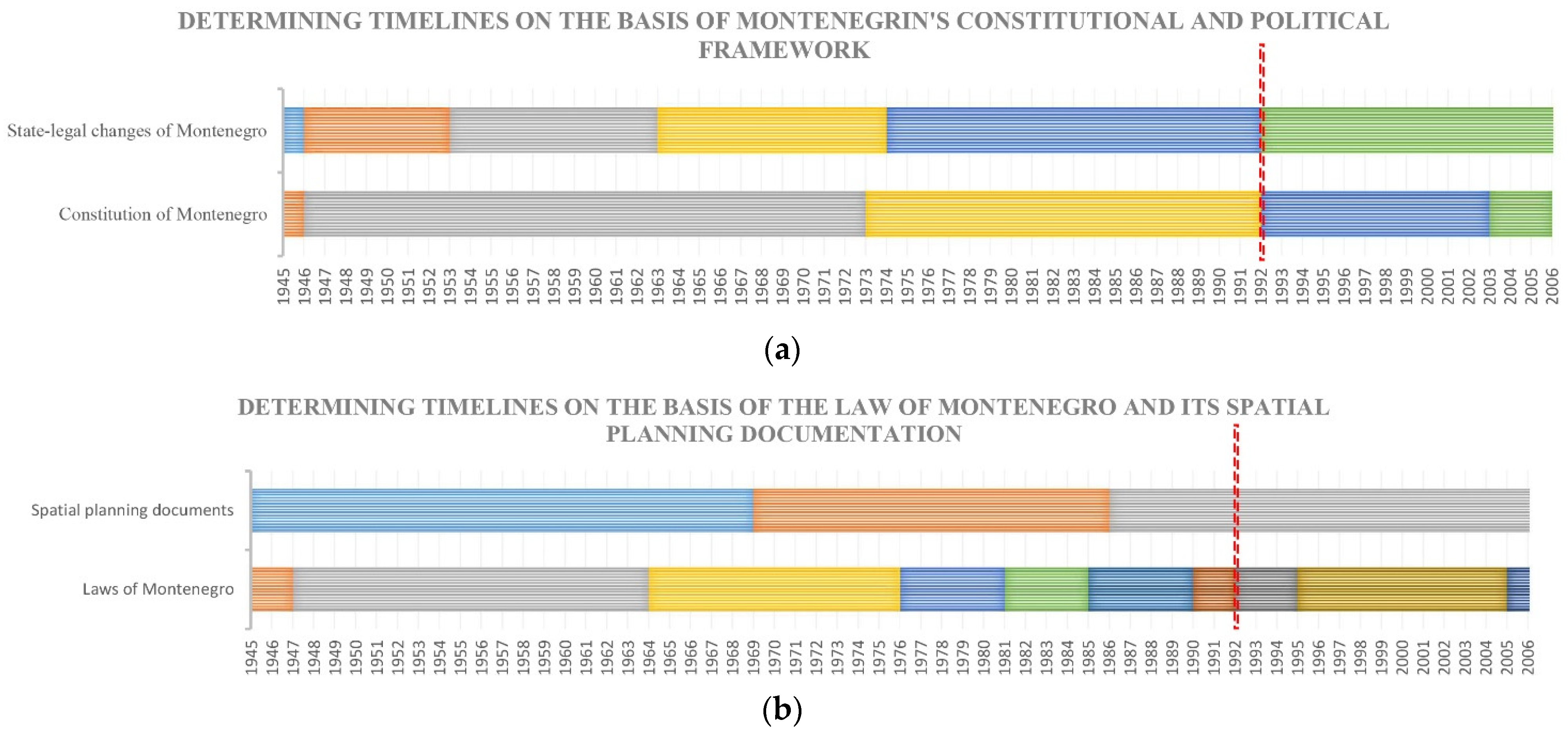
2.2. Planning Legislation as well as Analysis and Evaluation of Physical Planning Documentation of Boka Kotorska Adopted in the Observed Period
- -
- Criteria of natural values (based on identity attributes of the natural environment);
- -
- The criteria of cultural–historical values (based on the identity characteristics of the historical–cultural environment);
- -
- Spatial–urban criteria (based on the identity attributes of the built environment);
- -
- Economic criteria (based on economic identity characteristics).
- -
- Features from the natural environment;
- -
- Features from the cultural and historical environment;
- -
- Features from the built environment;
- -
- Economic characteristics.
3. Results
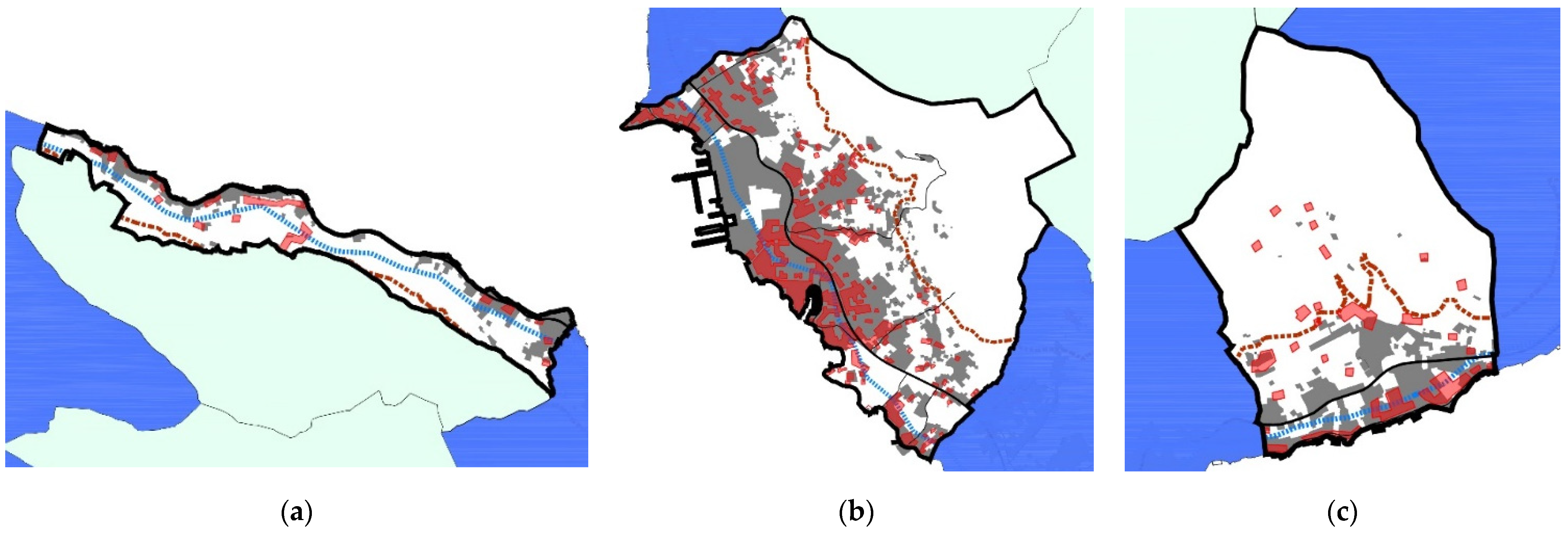
3.1. Analysis and Comparison of the Transformation of Urban Structures of the Subject Coastal Settlements of Boka Kotorska during the Observed Period
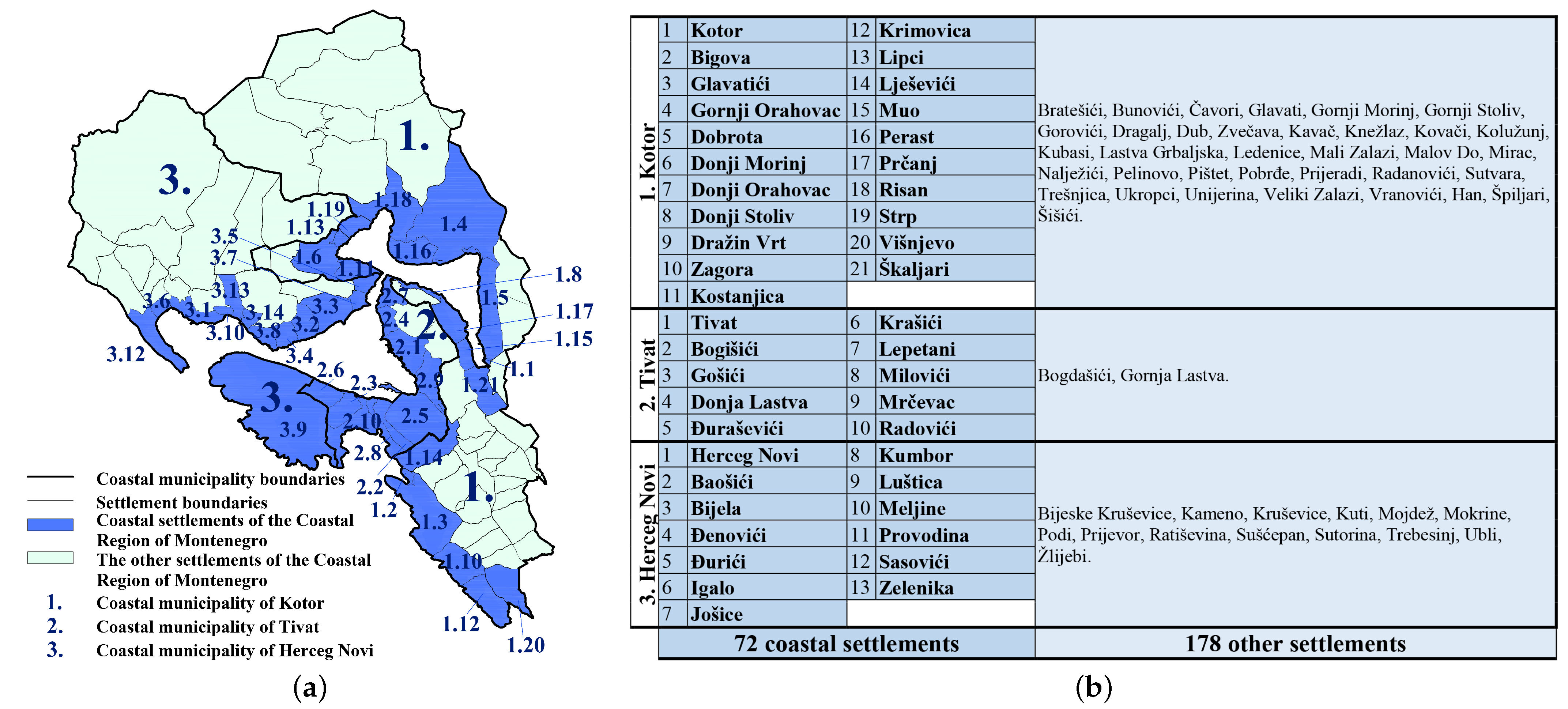
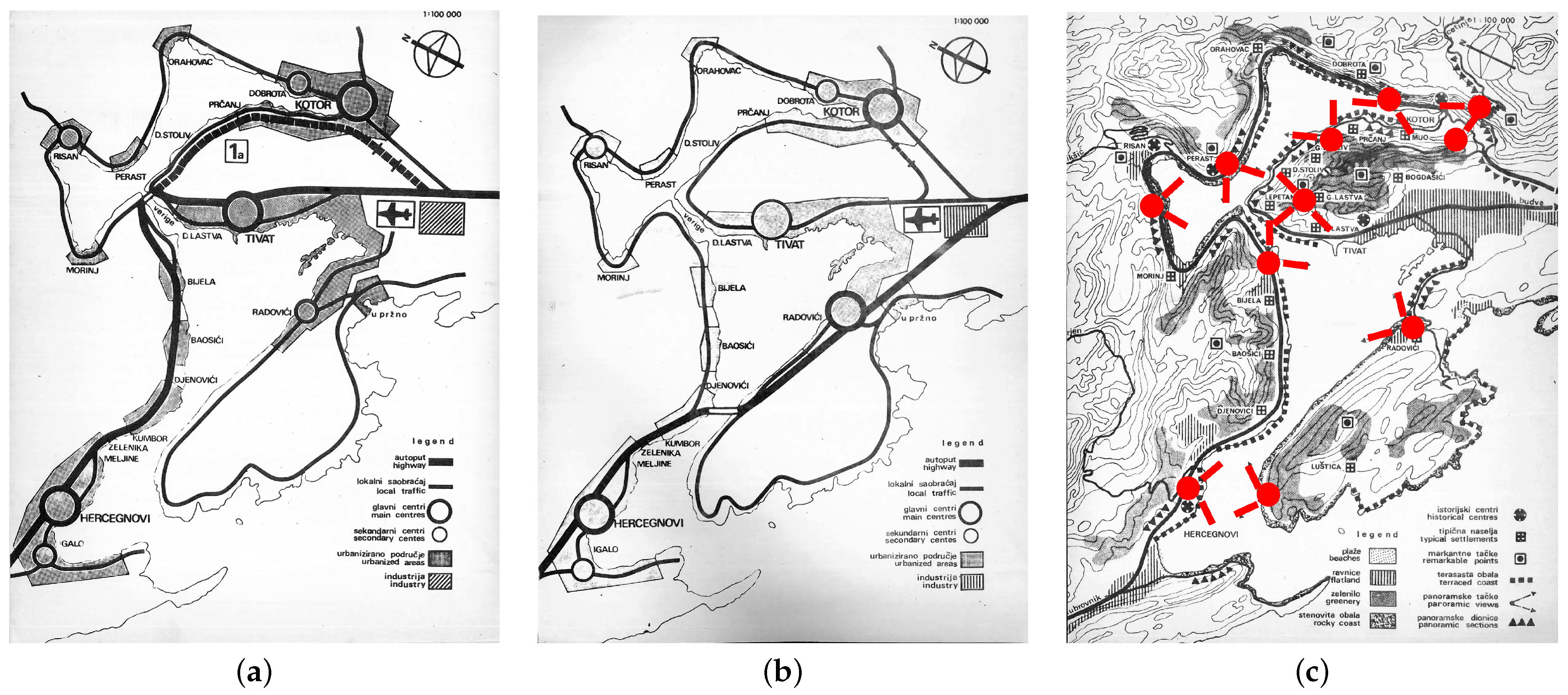
3.2. Distinctive Elements and Features of Spatial Development of the Coastal Municipalities of Kotor, Tivat and Herceg Novi
3.2.1. Natural Features of the Municipalities of Kotor, Tivat and Herceg Novi
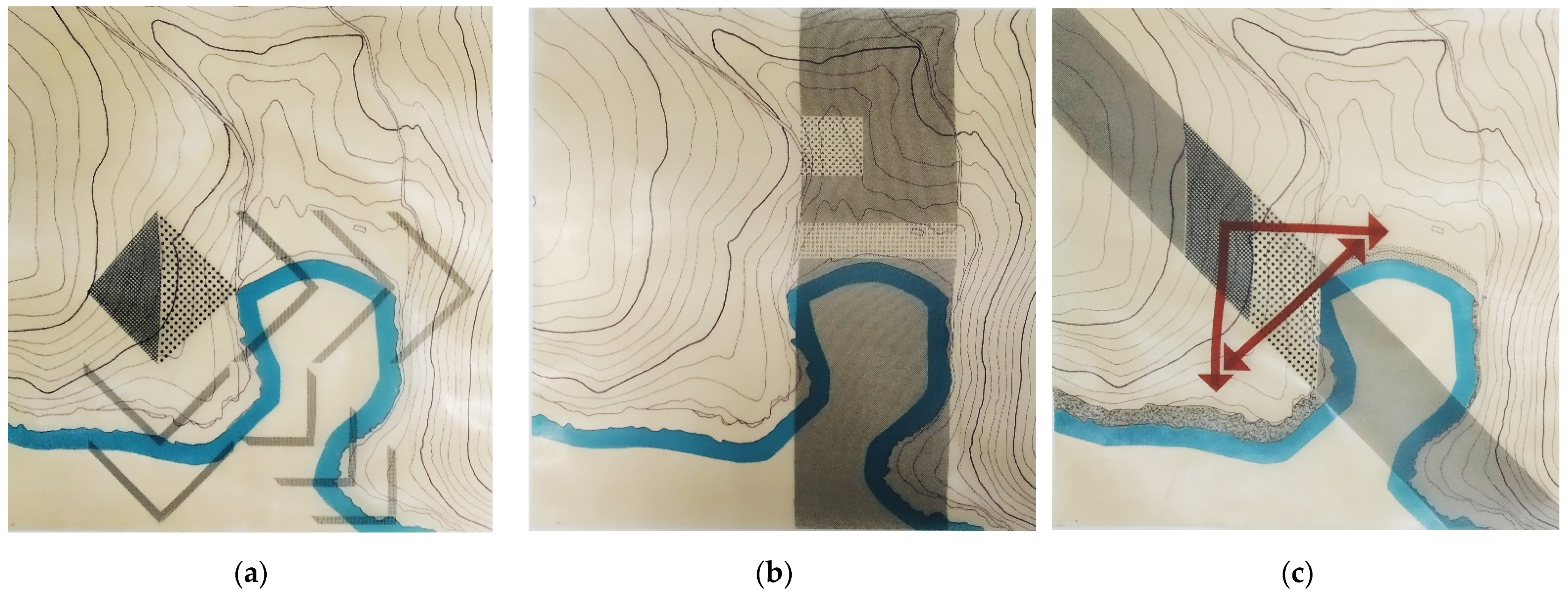
3.2.2. Features of the Cultivated Landscape of Boka Kotorska
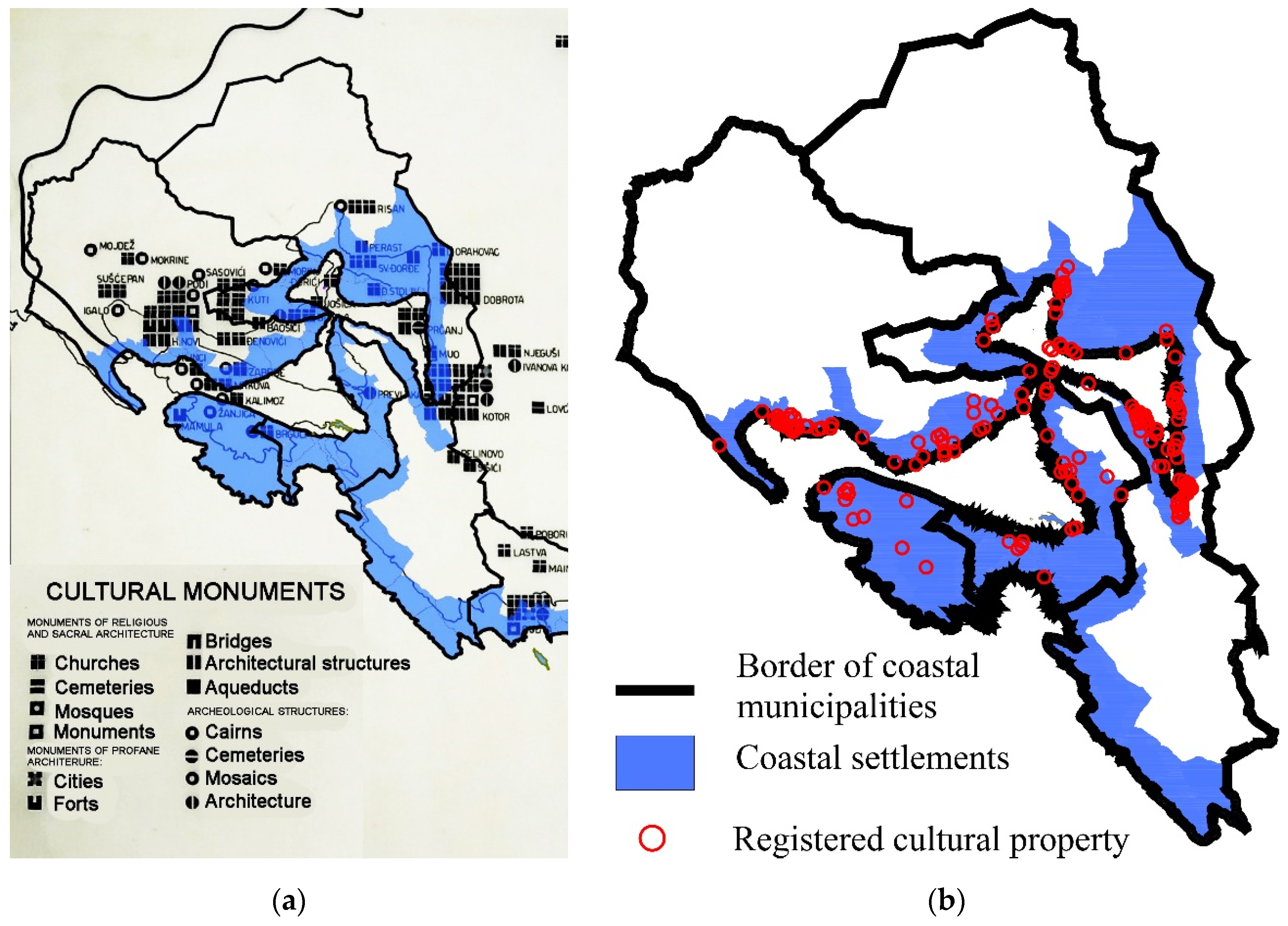
3.2.3. Distinctive Elements of the Built-Up (and Cultural–Historical) Environment
4. Discussion
4.1. Identified Planning Criteria for the Improvement of Coastal Settlements of Boka Kotorska
4.2. Planning Models of the Development of Settlements on the Shores of the Municipalities of Kotor, Tivat and Herceg Novi
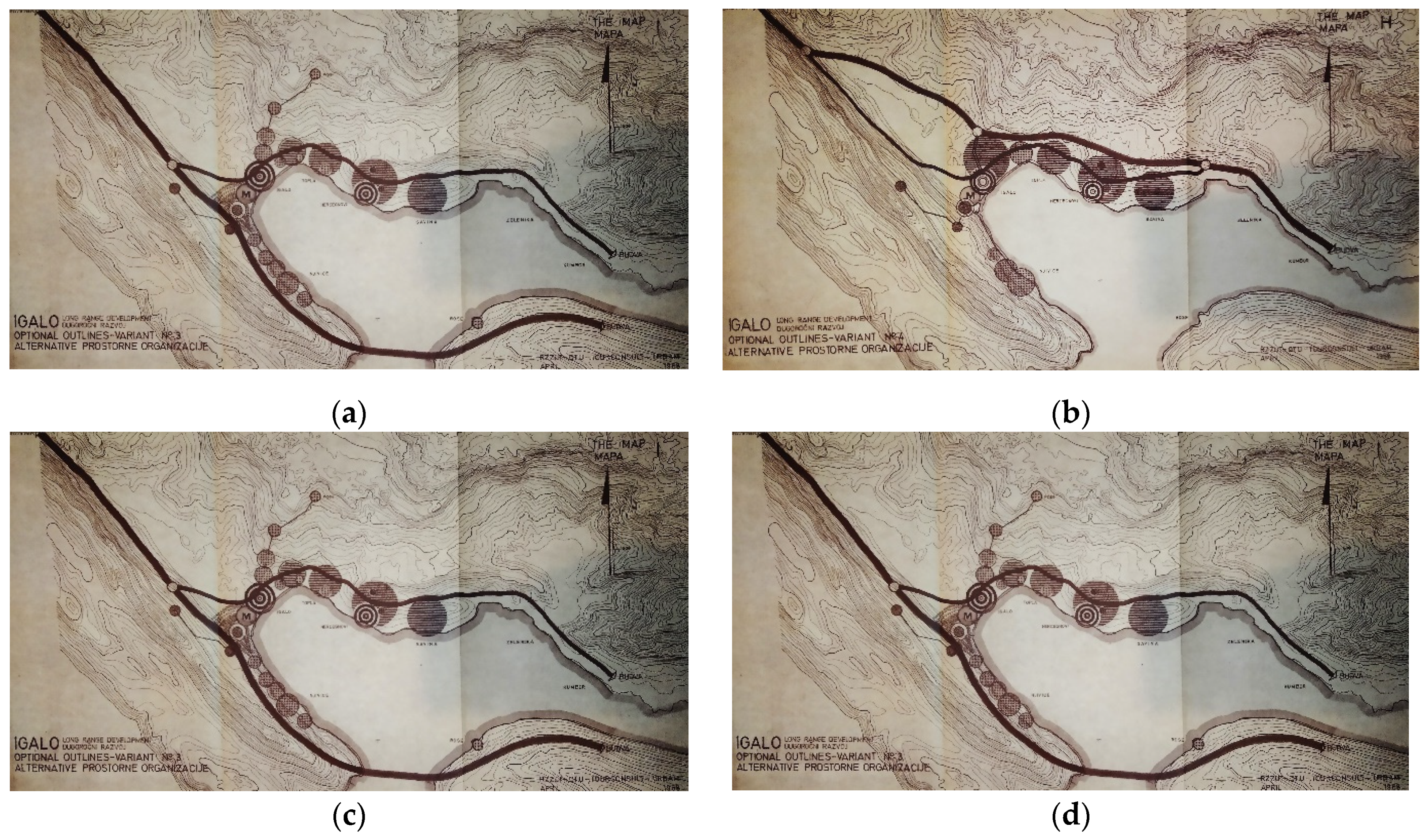
4.3. Proposal of New Criteria and Models for the Development of Urban Structures of Coastal Settlements of Boka Kotorska
5. Conclusions
Author Contributions
Funding
Institutional Review Board Statement
Informed Consent Statement
Data Availability Statement
Acknowledgments
Conflicts of Interest
References
- European Environment Agency. The Changing Faces of Europe’s Coastal Areas, 1st ed.; Office for Official Publications of the European Communities: Copenhagen, Denmark, 2006; p. 107. [Google Scholar]
- Berlengi, G. CAMP Crna Gora—Definisanje Obalnog Odmaka, 1st ed.; Ministry of Sustainable Development and Tourism of Montenegro, Priority Actions Programme Regional Activity Centre (PAP/RAC): Podgorica, Montenegro, 2013; p. 28. [Google Scholar]
- Knežević, J.; Berlengi, G.; Marković, M.; Mlakar, A. Nacionalne Strategije Integralnog Upravljanja Obalnim Područjem Crne Gore, Nacrt, 1st ed.; Ministarstvo Održivog Razvoja i Turizma Crne Gore, Priority Actions Programme Regional Activity Centre (PAP/RAC): Podgorica, Montenegro, 2013; p. 185. [Google Scholar]
- Camagni, R. Urban Development and Control on Urban Land Rents; Springer: Cham, Switzerland, 2016; Volume 56, pp. 597–615. [Google Scholar]
- Morano, P.; Tajani, F.; Anelli, D. Urban planning variants: A model for the division of the activated “plusvalue” between public and private subjects. Valori E Valutazioni 2021, 28, 31–47. [Google Scholar] [CrossRef]
- Government of the Socialist Republic of Montenegro. Law on Urban and Regional Planning (Official Gazette of the Socialist Republic of Montenegro 36/64, 28/71 and 29/73). 1964. Available online: http://www.sluzbenilist.me/pregled-dokumenta/?id={A8006CA8-D9B7-4C4A-8DB0-2CB8F98C869B} (accessed on 19 October 2020).
- Government of the Socialist Republic of Montenegro. Law on Spatial Planning and Arrangement (Official Gazette of the Socialist Republic of Montenegro 23/76). 1976. Available online: http://www.sluzbenilist.me/pregled-dokumenta/?id={D6F56D4F-90EC-46E1-9F50-96E76FBC07D2} (accessed on 23 October 2020).
- Government of the Socialist Republic of Montenegro. Law on Spatial Planning and Arrangement (Official Gazette of the Socialist Republic of Montenegro 19/79). 1979. Available online: http://www.sluzbenilist.me/pregled-dokumenta/?id={DADA3C37-65CF-4495-9EB2-EE335B2269ED} (accessed on 23 October 2020).
- Government of the Socialist Republic of Montenegro. Law on Spatial Planning and Arrangement (Official Gazette of the Socialist Republic of Montenegro 16/81). 1981. Available online: http://www.sluzbenilist.me/pregled-dokumenta/?id={2DAF6EB9-2692-4844-8F11-E3B6A5126188} (accessed on 23 October 2020).
- Government of the Socialist Republic of Montenegro. Law on Spatial Planning and Arrangement (Official Gazette of the Socialist Republic of Montenegro 7/85). 1985. Available online: http://www.sluzbenilist.me/pregled-dokumenta/?id={26BC9B38-7195-4E17-B22F-B85C60317DC3} (accessed on 23 October 2020).
- Government of the Socialist Republic of Montenegro. Law on Spatial Planning and Arrangement (Official Gazette of the Socialist Republic of Montenegro 46/90). 1990. Available online: http://www.sluzbenilist.me/pregled-dokumenta/?id={640A8CCF-BC58-4792-AE0A-6FD104826C7A} (accessed on 23 October 2020).
- Government of the Republic of Montenegro. Law on Spatial Planning and Arrangement (Official Gazette of the Republic of Montenegro 16/95). 1995. Available online: http://www.sluzbenilist.me/pregled-dokumenta/?id={052D8ED9-8B89-4544-9381-54D8F2926C72} (accessed on 20 October 2020).
- Government of the Republic of Montenegro. Law on Spatial Planning and Arrangement (Official Gazette of the Republic of Montenegro 28/05). 2005. Available online: http://www.sluzbenilist.me/pregled-dokumenta/?id={071513E8-1345-40D5-B718-FA14472AC993} (accessed on 20 October 2020).
- Government of Montenegro. Law on Spatial Planning and Construction of Facilities (Official Gazette of Montenegro 64/17, 44/18, 63/18, 11/19 and 82/20). 2020. Available online: http://www.sluzbenilist.me/pregled-dokumenta/?id={1CB6CE0B-ED9B-4925-B5D4-4F89156F076D} (accessed on 20 October 2020).
- Government of the Socialist Republic of Montenegro. Prostorni Plan Savezne Republike Crne Gore do 2000. Godine (Official Gazette of SR Montenegro 16/86). 1986. Available online: http://www.sluzbenilist.me/pregled-dokumenta/?id={5973D970-7E0C-46C4-AB69-194D8047E3FC} (accessed on 15 September 2020).
- Government of the Socialist Republic of Montenegro. Izmjene i Dopune Prostornog Plana Republike Crne Gore do 2000. Godine (Official Gazette of SR Montenegro 46/90). 1990. Available online: http://www.sluzbenilist.me/pregled-dokumenta/?id={640A8CCF-BC58-4792-AE0A-6FD104826C7A} (accessed on 15 September 2020).
- Government of the Socialist Republic of Montenegro. Izmjene i Dopune Prostornog Plana Republike Crne Gore do 2000. Godine (Official Gazette of the Republic of Montenegro 17/97). 1997. Available online: http://www.sluzbenilist.me/pregled-dokumenta/?id={025B3133-D1A5-4E2E-8B65-91718A304803} (accessed on 15 September 2020).
- Government of Montenegro. Prostorni Plan Republike Crne Gore (Official Gazette of the Republic of Montenegro 24/08). 2008. Available online: http://www.sluzbenilist.me/pregled-dokumenta/?id={670DB537-0E1E-4952-8B42-1965442B18D1} (accessed on 15 September 2020).
- Republički Zavod za Urbanizam, Titograd. Regionalni Prostorni Plan Crnogorskog Primorja; Republički Zavod za Urbanizam, Titograd: Podgorica, Montenegro, 1966. [Google Scholar]
- Urbanistički Institut SR Hrvatske, Republički Zavod za Urbanizam SR Crne Gore, Urbanistički Zavod SR Bosne i Hercegovine, Institut za Ekonomiku Turizma—Zagreb, Međunarodni Konzultativni Konzorcijum Tekna, Milan, Cekop, Warzaw. Prirodno Geografske Karakteristike (Osnovna Studija), Regionalni Prostorni Plan Južni Jadran; Urbanistički Institut SR Hrvatske: Dubrovnik, Croatia, 1968; p. 235. [Google Scholar]
- Urbanistički Institut SR Hrvatske, Republički Zavod za Urbanizam SR Crne Gore, Urbanistički Zavod SR Bosne i Hercegovine, Institut za Ekonomiku Turizma—Zagreb, Međunarodni Konzultativni Konzorcijum Tekna, Milan, Cekop, Warzaw. Naselja, Objekti Društvenog Standarda i Servisi (Osnovna Studija), Regionalni Prostorni Plan Južni Jadran; Urbanistički Institut SR Hrvatske: Dubrovnik, Croatia, 1968; p. 128. [Google Scholar]
- Urbanistički Institut SR Hrvatske, Republički Zavod za Urbanizam SR Crne Gore, Urbanistički Zavod SR Bosne i Hercegovine, Institut za Ekonomiku Turizma—Zagreb, Međunarodni Konzultativni Konzorcijum Tekna, Milan, Cekop, Warzaw. Pejzaž (Osnovna Studija), Regionalni Prostorni Plan Južni Jadran; Urbanistički Institut SR Hrvatske: Dubrovnik, Croatia, 1968; p. 123. [Google Scholar]
- Urbanistički Institut SR Hrvatske, Republički Zavod za Urbanizam SR Crne Gore, Urbanistički Zavod SR Bosne i Hercegovine, Institut za Ekonomiku Turizma—Zagreb, Međunarodni Konzultativni Konzorcijum Tekna, Milan, Cekop, Warzaw. Spomenici Kulture (Osnovna Studija), Regionalni Prostorni Plan Južni Jadran; Urbanistički Institut SR Hrvatske: Dubrovnik, Croatia, 1968; p. 224. [Google Scholar]
- Urbanistički Institut SR Hrvatske, Republički Zavod za Urbanizam SR Crne Gore, Urbanistički Zavod SR Bosne i Hercegovine, Institut za Ekonomiku Turizma—Zagreb, Međunarodni Konzultativni Konzorcijum Tekna, Milan, Cekop, Warzaw. Zaštita Prirode (Osnovna Studija), Regionalni Prostorni Plan Južni Jadran; Urbanistički Institut SR Hrvatske: Dubrovnik, Croatia, 1968; p. 188. [Google Scholar]
- Urbanistički Institut SR Hrvatske, Republički Zavod za Urbanizam SR Crne Gore, Urbanistički Zavod SR Bosne i Hercegovine, Institut za Ekonomiku Turizma—Zagreb, Međunarodni Konzultativni Konzorcijum Tekna, Milan, Cekop, Warzaw. Zaključci Osnovne Studije Prirodno Geografske Karakteristike (Završni Izvještaj), Regionalni Prostorni Plan Južni Jadran; Urbanistički Institut SR Hrvatske: Dubrovnik, Croatia, 1968; p. 25. [Google Scholar]
- Urbanistički Institut SR Hrvatske, Republički Zavod za Urbanizam SR Crne Gore, Urbanistički Zavod SR Bosne i Hercegovine, Institut za Ekonomiku Turizma—Zagreb, Međunarodni Konzultativni Konzorcijum Tekna, Milan, Cekop, Warzaw. Zaključci Osnovne Studije Spomenici Kulture (Završni Izvještaj), Regionalni Prostorni Plan Južni Jadran; Urbanistički Institut SR Hrvatske: Dubrovnik, Croatia, 1968; p. 31. [Google Scholar]
- Urbanistički Institut SR Hrvatske, Republički Zavod za Urbanizam SR Crne Gore, Urbanistički Zavod SR Bosne i Hercegovine, Institut za Ekonomiku Turizma—Zagreb, Međunarodni Konzultativni Konzorcijum Tekna, Milan, Cekop, Warzaw. Zaključci Osnovne Studije—Unapređenje Pejzaža i Prijedloga Zaštite Prirode (Završni Izvještaj), Prostorni Plan Južni Jadran; Urbanistički Institut SR Hrvatske: Dubrovnik, Croatia, 1968; p. 35. [Google Scholar]
- Republički Zavod za Urbanizam i Projektovanje, MonteCep ad, Horwath HTL. Prostorni Plan Posebne Namjene za Obalno Područje Crne Gore; Ministry of Sustainable Development and Tourism: Podgorica, Montenegro, 2018; p. 299. [Google Scholar]
- Republički Zavod za Urbanizam i Projektovanje, MonteCep ad, Horwath HTL. Analiza Postojećeg Stanja PPPN za Obalno Područje Crne Gore; Ministry of Sustainable Development and Tourism: Podgorica, Montenegro, 2018; p. 285. [Google Scholar]
- Republički Zavod za Urbanizam i Projektovanje, OTAM, TOURCUNSULT, URBAM. Generalni Planovi Budve i Ulcinja i Detaljni Plan Igala, Međuizvještaj B: Alternative Prostorne Organizacije; Republički Zavod za Urbanizam i Projektovanje, Titograd: Budva, Montenegro, 1968; p. 52. [Google Scholar]
- Republički Zavod za Urbanizam i Projektovanje, OTAM, TOURCUNSULT, URBAM. Generalni Planovi Budve i Ulcinja i Detaljni Plan Igala, Međuizvještaj C: Pragovi Fizičkog Razvoja; Republički Zavod za Urbanizam i Projektovanje, Titograd: Budva, Montenegro, 1968; p. 56. [Google Scholar]
- Republički Zavod za Urbanizam i Projektovanje, OTAM, TOURCUNSULT, URBAM. Generalni Plan Boke Kotorske, Knjiga 1: Plan; Republički Zavod za Urbanizam i Projektovanje, Titograd: Budva, Montenegro, 1970; p. 170. [Google Scholar]
- Republički Zavod za Urbanizam i Projektovanje, OTAM, TOURCUNSULT, URBAM. Generalni Plan Boke Kotorske: Predkoncepcije; Republički Zavod za Urbanizam i Projektovanje, Titograd: Budva, Montenegro, 1969; p. 83. [Google Scholar]
- Republički Zavod za Urbanizam i Projektovanje, OTAM, TOURCUNSULT, URBAM. Generalni Plan Boke Kotorske, Knjiga 2: Osnovni Rezultati; Republički Zavod za Urbanizam i Projektovanje, Titograd: Budva, Montenegro, 1970; p. 345. [Google Scholar]
- Urbanistički Institut SR Hrvatske. Generalni Urbanistički Plan Boka Kotorska (Kotor); Urbanistički Institut SR Hrvatske: Zagreb, Croatia, 1987. [Google Scholar]
- Republički Zavod za Urbanizam i Projektovanje, OTAM, TOURCUNSULT. Prostorni Plan Opštine Kotor; Republički Zavod za Urbanizam, Titograd: Podgorica, Montenegro, 1987. [Google Scholar]
- Centar za Planiranje Urbanog Razvoja, Beograd. Prostorno Urbanistički Plan Kotora, Izmjene i Dopune; Centar za Planiranje Urbanog Razvoja, Beograd: Beograd, Serbia, 1995. [Google Scholar]
- Centar za Planiranje Urbanog Razvoja, Beograd. Generalni Urbanistički Plan Kotora, Izmjene i Dopune; Centar za Planiranje Urbanog Razvoja, Beograd: Beograd, Serbia, 1998. [Google Scholar]
- Republički Zavod za Urbanizam i Projektovanje, OTAM. Detaljni Plan Morinj; Republički Zavod za Urbanizam, Titograd: Podgorica, Montenegro, 1970. [Google Scholar]
- Republički Zavod za Urbanizam i Projektovanje, OTAM. Detaljni Plan Markov Rt; Republički Zavod za Urbanizam, Titograd: Podgorica, Montenegro, 1970. [Google Scholar]
- Zavod za Projektovanje i Urbanizam Herceg Novi. Plan Uređenja Manjeg Naselja Stoliv i Prčanj; Zavod za Projektovanje i Urbanizam Herceg Novi: Herceg Novi, Montenegro, 1992. [Google Scholar]
- Republički Zavod za Urbanizam i Projektovanje, OTAM, TOURCONSULT. Generalni Urbanistički Plan Boka Kotorska (Tivat); Republički Zavod za Urbanizam, Titograd: Podgorica, Montenegro, 1970. [Google Scholar]
- Republički Zavod za Urbanizam i Projektovanje. Detaljni Urbanistički Plan Tivat, Centar; Republički Zavod za Urbanizam, Titograd: Podgorica, Montenegro, 1980. [Google Scholar]
- Republički Zavod za Urbanizam i Projektovanje. Detaljni Urbanistički Plan Tivat, Centar, I Faza; Republički Zavod za Urbanizam i Projektovanje, Titograd: Podgorica, Montenegro, 1980; p. 26. [Google Scholar]
- Republički Zavod za Urbanizam i Projektovanje. Detaljni Urbanistički Plan Tivat, Centar, 2 Faza; Republički Zavod za Urbanizam i Projektovanje, Titograd: Podgorica, Montenegro, 1980; p. 113. [Google Scholar]
- Centar za Planiranje Urbanog Razvoja Beograd, Radna Organizacija za Obnovu i Izgradnju Tivat. Urbanistički Projekat Đurđevo Brdo; Centar za Planiranje Urbanog Razvoja Beograd: Beograd, Serbia, 1987; p. 154. [Google Scholar]
- Centar za Planiranje Urbanog Razvoja Beograd, Radna Organizacija za Obnovu i Izgradnju Tivat. Urbanistički Projekat Donja Lastva; Centar za Planiranje Urbanog Razvoja Beograd: Beograd, Serbia, 1987; p. 69. [Google Scholar]
- Centar za Planiranje Urbanog Razvoja Beograd, Radna Organizacija za Obnovu i Izgradnju Tivat. Urbanistički Projekat Gornji Krašići; Centar za Planiranje Urbanog Razvoja Beograd: Beograd, Serbia, 1987; p. 123. [Google Scholar]
- Centar za Planiranje Urbanog Razvoja Beograd, Radna Organizacija za Obnovu i Izgradnju Tivat. Urbanistički Projekat Lepetani; Centar za Planiranje Urbanog Razvoja Beograd: Beograd, Serbia, 1987; p. 166. [Google Scholar]
- Republički Zavod za Urbanizam i Projektovanje SR Crne Gore. Detaljni Plan Pržna; Republički Zavod za Urbanizam i Projektovanje, Titograd: Podgorica, Montenegro, 1969. [Google Scholar]
- Zavod za Projektovanje i Urbanizam Herceg Novi, Centar Ujedinjenih Nacija za Ljudska Prava, Organizacija Ujedinjenih Nacija za Otklanjanje Posljedica Katastrofa. Urbanistički Projekat Lepetani; Zavod za Projektovanje i Urbanizam Herceg Novi: Herceg Novi, Montenegro, 1979; p. 33. [Google Scholar]
- Republički Zavod za Urbanizam i Projektovanje SR Crne Gore, OTAM, TOURCONSULT. Generalni Urbanistički Plan Boka Kotorska (Herceg Novi); Republički Zavod za Urbanizam i Projektovanje, Titograd: Podgorica, Montenegro, 1970. [Google Scholar]
- Republički Zavod za Urbanizam i Projektovanje SR Crne Gore. Urbanistički Program Herceg Novog; Republički Zavod za Urbanizam i Projektovanje SR Crne Gore, Titograd: Podgorica, Montenegro, 1967. [Google Scholar]
- Republički Zavod za Urbanizam i Projektovanje SR Crne Gore, OTAM, TOURCONSULT. Detaljni Plan Igalo; Republički Zavod za Urbanizam i Projektovanje SR Crne Gore, Titograd: Podgorica, Montenegro, 1969. [Google Scholar]
- Radojičić, B. Geografija Crne Gore: Društvena Osnova i Regije, 1st ed.; Dukljanska Akademija Nauka i Umjetnosti, Odjeljenje Prirodnih Nauka: Podgorica, Montenegro, 2002; p. 612. [Google Scholar]
- Vlahović, P. Grad u Crnoj Gori i njegov etnološki značaj. In Etnologija Grada u Crnoj Gori, 1st ed.; Vlahović, P., Ed.; Crnogorska Akademija Nauka i Umjetnosti: Podgorica, Montenegro, 2009; Volume 1, pp. 7–21. [Google Scholar]
- Vujović, S. Glavni akteri socioprostornih promjena crnogorskih primorskih gradova u postsocijalističkom periodu. In Etnologija Grada u Crnoj Gori, 1st ed.; Vlahović, P., Ed.; Crnogorska Akademija Nauka i Umjetnosti: Podgorica, Montenegro, 2009; Volume 1, pp. 51–67. [Google Scholar]
- Radusinović, P. Neka Demografska Obilježja Primorskog Regiona Crne Gore, 1st ed.; Geografsko Društvo BiH: Sarajevo, Bosna i Hercegovina, 1966; p. 120. [Google Scholar]
- Devedžić, M. Turizam kao faktor promena u razvoju, razmeštaju i strukturama stanovništva Crnogorskog primorja. Ph.D. Thesis, Univerzitet u Beogradu, Beograd, Serbia, 1999. [Google Scholar]
- Devedžić, M. Uticaj Turizma na Demografski Razvitak: Primer Crnogorskog Primorja, 1st ed.; Geografski Fakultet Univerziteta: Beograd, Serbia, 2011; p. 171. [Google Scholar]
- Turčinović, F. Međunarodni Pravni Dokumenti Kulturnog i Prirodnog Nasljeđa na Crnogorskom Primorju, 1st ed.; Obod: Cetinje, Montenegro, 1994; p. 100. [Google Scholar]
- Centar za Konzervaciju i Arheologiju Crne Gore. Studija Zaštite Kulturnih Dobara u Obuhvatu Prostornog Plana Posebne Namjene Obalno Područje, Opština Tivat; Ministarstvo Kulture: Cetinje, Montenegro, 2016; p. 372. [Google Scholar]
- Centar za Konzervaciju i Arheologiju Crne Gore. Studija Zaštite Kulturnih Dobara u Obuhvatu Prostornog Plana Posebne Namjene Obalno Područje, Opština Herceg Novi I; Ministarstvo Kulture: Cetinje, Montenegro, 2016; p. 520. [Google Scholar]
- Centar za Konzervaciju i Arheologiju Crne Gore. Studija Zaštite Kulturnih Dobara u Obuhvatu Prostornog Plana Posebne Namjene Obalno Područje, Opština Herceg Novi II; Ministarstvo Kulture: Cetinje, Montenegro, 2016; p. 429. [Google Scholar]
- Centar za Konzervaciju i Arheologiju Crne Gore. Studija Zaštite Kulturnih Dobara u Obuhvatu Prostornog PLANA Posebne Namjene Obalno Područje, Opština Herceg Novi III; Ministarstvo Kulture: Cetinje, Montenegro, 2016; p. 580. [Google Scholar]
- Centar za Konzervaciju i Arheologiju Crne Gore. Studija Zaštite Kulturnih Dobara u Obuhvatu Prostornog Plana Posebne Namjene Obalno Područje, Opština Kotor I; Ministarstvo Kulture: Cetinje, Montenegro, 2016; p. 672. [Google Scholar]
- Centar za Konzervaciju i Arheologiju Crne Gore. Studija Zaštite Kulturnih Dobara u Obuhvatu Prostornog Plana Posebne Namjene Obalno Područje, Opština Kotor II; Ministarstvo Kulture: Cetinje, Montenegro, 2016; p. 671. [Google Scholar]
- Centar za Konzervaciju i Arheologiju Crne Gore. Studija Zaštite Kulturnih Dobara u Obuhvatu Prostornog Plana Posebne Namjene Obalno Područje, Opština Kotor III; Ministarstvo Kulture: Cetinje, Montenegro, 2016; p. 539. [Google Scholar]
- Centar za Konzervaciju i Arheologiju Crne Gore. Studija Zaštite Kulturnih Dobara u Obuhvatu Prostornog Plana Posebne Namjene Obalno Područje, Opština Kotor IV; Ministarstvo Kulture: Cetinje, Montenegro, 2016; p. 415. [Google Scholar]
- Centar za Konzervaciju i Arheologiju Crne Gore. Studija Zaštite Kulturnih Dobara za Potrebe Izrade Prostorno-Urbanističkog Plana Opštine Kotor; Ministarstvo Kulture: Kotor, Montenegro, 2015; p. 412. [Google Scholar]
- Ilijanić, B. Urbana Geneza: Herceg Novi–Stari Grad, Crna Gora, Istočna Obala Jadranskog Mora; Ilibo Design Architects: Herceg Novi, Montenegro, 2015; p. 171. [Google Scholar]
- Lalošević, I. Utvrđeni gradovi Boke Kotorske iz mletačkog razdoblja. Rad. Zavoda Za Povij. Znan. HAZU U Zagrebu 2016, 58, 115–146. [Google Scholar]
- Government of the Socialist Republic of Montenegro. Zakon o Izmjenama i Dopunama Zakona o Teritorijalnoj Organizaciji Crne Gore (Official Gazette of the Socialist Republic of Montenegro 54/11). 2011. Available online: http://www.sluzbenilist.me/pregled-dokumenta-2/?id={93EBF99F-C6F5-4ED5-8B6A-9AD226D50C93} (accessed on 5 December 2020).
- Zavod za Statistiku Republike Crne Gore-MONSTAT. Popis Stanovništva, Domaćinstva i Stanova u 2003—Uporedni Pregled Broja Stanovnika 1948, 1953, 1961, 1971, 1981, 1991. i 2003; NJP Pobjeda: Podgorica, Montenegro, 2005; p. 123. [Google Scholar]
- Government of Republic of Montenegro and Government of Montenegro. Zakon o Morskom Dobru (Official Gazette of the Republic of Montenegro 14/92, 59/92, 27/94 and Official Gazette of Montenegro 51/08, 21/09, 73/10, 40/11). 1992. Available online: http://www.sluzbenilist.me/pregled-dokumenta-2/?id={F27B70D2-5001-4F3F-838B-879DF01ADA22} (accessed on 3 December 2020).
- Official Gazette of the Kingdom of Yugoslavia. Construction Act (Official Gazette of the Kingdom of Yugoslavia 133/31); Official Gazette of the Kingdom of Yugoslavia: Belgrade, Yugoslavia, 1931. [Google Scholar]
- Government of Montenegro. Law on Spatial Planning and Construction of Facilities (Official Gazette of Montenegro 51/08, 34/11, 35/13 and 33/14). 2014. Available online: http://www.sluzbenilist.me/pregled-dokumenta-2/?id={54F0E6DE-A56B-442F-A5AF-D29ABABDC9F9} (accessed on 20 October 2021).
- Republički Zavod za Urbanizam i Projektovanje SR Crne Gore. Regionalni Prostorni Plan Crnogorsko Primorja (Program i Plan); Republički Zavod za Urbanizam i Projektovanje SR Crne Gore, Titograd: Podgorica, Montenegro, 1966. [Google Scholar]
- Republički Zavod za Urbanizam i Projektovanje SR Crne Gore, URBAM, OTAM, TOURCONSULT. Regionalni Prostorni Plan Južni Jadran; Republički Zavod za Urbanizam i Projektovanje SR Crne Gore, Titograd: Podgorica, Montenegro, 1968. [Google Scholar]
- Republički Zavod za Urbanizam i Projektovanje SR Crne Gore, OTAM, TOURCONSULT. Generalni Urbanistički Plan Boka Kotorska (Kotor); Republički Zavod za Urbanizam, Titograd: Podgorica, Montenegro, 1970. [Google Scholar]
- Republički Zavod za Urbanizam i Projektovanje SR Crne Gore, Organizacija Ujedinjenih Nacija za Otklanjanje Posljedica Katastrofa, Centar Ujedinjenih Nacija za Ljudska Naselja. Prostorni Plan Opštine Herceg Novi; Republički Zavod za Urbanizam i Projektovanje SR Crne Gore: Podgorica, Montenegro, 1979. [Google Scholar]
- Špadijer, M. Crna Gora, 15. IV 1979, 1st ed.; Pobjeda: Podgorica, Montenegro, 1979; p. 55. [Google Scholar]
- Dragašević, R. Osvrt na razvoj proizvodnih snaga u Crnoj Gori i neke probleme u razmještaju turističke djelatnosti u primorskom dijelu Republike. In Jugoslovenski Simpozijum o Prostornom i Urbanističkom Planiranju u Seizmičkim Uslovima, 1st ed.; Milić, B., Ed.; Republički Zavod za Urbanizam, Građevinarstvo i Stambeno-Komunalne Poslove: Podgorica, Montenegro, 1982; pp. 231–240. [Google Scholar]
- Petričić, K.; Šćitaroci, O.M. Kriteriji vrjednovanja ruralnih naselja u zaštićenim prirodnim područjima, Primjer nacionalnog parka Plitvička jezera. In Heru, Prostorne i Razvojne Mogućnosti Kulturnog Naslijeđa, 1st ed.; Šćitaroci, O.M., Ed.; Sveučilište u Zagrebu, Arhitektonski Fakultet: Zagreb, Croatia, 2015; pp. 120–125. [Google Scholar]
- Republički Zavod za Urbanizam i Projektovanje Podgorica. Mapiranje i Tipologija Predjela Crne Gore, Izdvojeni Osnovni Tipovi Predjela i Područja Karaktera Predjela, 1st ed.; Ministry of Sustainable Development and Tourism: Podgorica, Montenegro, 2015; p. 166. [Google Scholar]
- Republički Zavod za Urbanizam i Projektovanje SR Crne Gore. Studija Stanja Čovjekove Okoline Općine Tivat—Projekat Zaštite Čovjekove Okoline u Jadranskoj Regiji Jugoslavije; Municipality of Tivat: Tivat, Montenegro, 1979; p. 35. [Google Scholar]
- Republički Zavod za Urbanizam i Projektovanje SR Crne Gore. Područje Budve, Prostorni Plan i Program za Generalne Planove Priobalnih Naselja; Republički Zavod za Urbanizam i Projektovanje SR Crne Gore: Podgorica, Montenegro, 1967; p. 300. [Google Scholar]
- Čubrović, Z.; Grgurević, J.; Lalošević, I.; Kapetanović. Prirodno i Kulturno-Istorijsko Područje Kotora na Listi Svjetske Baštine UNESCO-a, 1st ed.; EPEDITIO Centar za Održivi Prostorni Razvoj, Kotor: Kotor, Montenegro, 2020; p. 95. [Google Scholar]
- Republički Zavod za Urbanizam i Projektovanje SR Crne Gore. Studija Stanja Čovjekove Okoline Općine Herceg Novi—Projekat Zaštite Čovjekove Okoline u Jadranskoj Regiji Jugoslavije; Municipality of Herceg Novi: Herceg Novi, Montenegro, 1979; p. 39. [Google Scholar]
- Društvo za Puteve SR Crne Gore, Titograd. Putevi u SR Crnoj Gori 1945–1985, 1st ed.; Društvo za Puteve SR Crne Gore, Titograd: Podgorica, Montenegro, 1986; p. 219. [Google Scholar]
- Republički Zavod za Urbanizam i Projektovanje SR Crne Gore, OTAM, TOURCUNSULT, URBAM. Generalni Planovi Budve, Knjiga 2: Plan; Republički Zavod za Urbanizam i Projektovanje, Titograd: Budva, Montenegro, 1968; p. 287. [Google Scholar]
- Republički Zavod za Urbanizam i Projektovanje SR Crne Gore, OTAM, TOURCUNSULT, URBAM. Generalni Planovi Budve i Ulcinja, Međuizvještaj K: Spomenici Kulture; Republički Zavod za Urbanizam i Projektovanje, Titograd: Budva, Montenegro, 1969; p. 73. [Google Scholar]
- Government of Montenegro. Zakon o Zaštiti Kulturnih Dobara Crne Gore (Official Gazette of Montenegro 49/10). 2010. Available online: http://www.sluzbenilist.me/pregled-dokumenta-2/?id={9C7D766D-D429-4D96-A6F9-4836B92A6996} (accessed on 2 February 2021).
- Marinović Uzelac, A. Naselja, Gradovi, Prostori, 1st ed.; Tehnička Knjiga: Zagreb, Croatia, 1986; p. 364. [Google Scholar]
- Republički Zavod za Urbanizam i Projektovanje SR Crne Gore, OTAM, TOURCUNSULT, URBAM. Generalni Planovi Budve, Međuizvještaj I, Knjiga 1: Analiza; Republički Zavod za Urbanizam i Projektovanje, Titograd: Budva, Montenegro, 1968; p. 181. [Google Scholar]

| Subject of Research | Used Documentation | Methods/ Procedures | Aim/Contribution of the Research | |||
|---|---|---|---|---|---|---|
| Conceptual definition of spatial units |  | Legislative, by-law documents and physical planning documents | | Analysis, comparison and creation of cartograms |  | Proposal for the introduction of new descriptions for existing concepts, as well as new concepts with detailed descriptions |
| Determination of time dividers | | Legislative documents, physical planning documents, constitutions, declarations | | Analysis and comparison of changes in the constitutional and political, legal and spatial planning framework of Montenegro | | Division of periods for easier monitoring of the most significant changes in the occurrence of coastal settlements and their results |
| The influence of state and local physical planning documents and legal acts on the planned development of coastal settlements |  | Legislative and by-law documents |  | Analysis of the existence of identity attributes in physical planning documents and criteria for their improvement | | Understanding the process of creating PPDs and their impact on the development of coastal settlements (procedure for determining criteria for analysis and evaluation of PPD) |
| Identity attributes of the coastal settlements of Montenegro | | PPD, state maps, statistical data | | Graphic overlay of data, analysis and comparison | | Determination and evaluation of identity attributes and their impact on changes in space (built-up land) |
| Determination of planning criteria for the development and improvement of coastal settlements | | PPD | | Analysis and comparison | | Grouping of identity attributes as a basis for determining planning criteria |
 | ||||||
| Proposal to supplement the planning criteria (Determination of coefficients and capacity through mathematical equations based on identity attributes of coastal settlements) | ||||||
| Determination of general and special models for the development and improvement of coastal settlements | | PPD | | Analysis and comparison | | Grouping of identity attributes as a basis for determining planning models |
| | ||||||
| Proposal to supplement the planning models (based on the newly established planning criteria) | ||||||
| Acronym of Law | LURP [6] | LSPA [7,8] | LSPA [9] | LSPA [10] | LSPA [11] | LSPA [12] | LSPA [13] | Total Number of SPD: |
|---|---|---|---|---|---|---|---|---|
| Title of the Type of Physical Planning Documents (Acronym) | 1964/1971 1973 | 1976/1979 | 1981 | 1985 | 1990 | 1995 | 2005 | |
| Program of the Regional Plan (PRP) | 1 (H) | 1 | ||||||
| General Regional Plan (GRP) | x (H) | - | ||||||
| Spatial Plan of the Republic (SPR) | x (H) | x (H) | 1 (H) | 1 (H) | 1 (H) | - | 3 | |
| Regional Spatial Plan (RSP) | 1 (H) | 1 (H) | x (H) | x (H) | x (H) | x (H) | 2 | |
| Spatial Plan of the Region (RSP) | ||||||||
| Spatial Plan of a Special Purpose Area (SPSPA) | x (H) | x (H) | x (H) | x (H) | x (H) | x (H) | - | |
| Municipal Spatial Plan (MSP) | 1 (H-HN) | x (H) | 1 (H-KO) | x (H) | 1 (H-KO) | x (L) | 3 | |
| Spatial Plan of the Local Self-Governance Unit (MSP) | ||||||||
| General Urban Plan (GUP) | 1 (L-KO); 1 (L-TV); 1 (L-HN) | x (H) | x (H) | 1 (H-KO) | x (L) | 1 (L-KO) | x (L) | 5 |
| Detailed Spatial Plan (DSP) | x (H) | x (H) | x (H) | - | ||||
| Local Study on Location (LSL) | x (L) | - | ||||||
| Study on Location (SL) | x (H) | - | ||||||
| Urban Program (UPg) | 1 (L-HN) | - | ||||||
| Smaller Settlement Spatial Plan (SSSP) | x (L) | x (L) | x (L) | 2 (L-KO) | 2 | |||
| Settlement Spatial Plan (SSP) | x (L) | |||||||
| Urban Settlement Plan (USP) | x (L) | |||||||
| Detailed Urban Plan (DUP) | 2(L-KO); 1(L-TV); 1(L-HN) | 1(L-TV) | x (L) | x (L) | x (L) | x (L) | x (L) | 5 |
| Urban Project (UP) | x (L) | x (L) | 4 (L-TV) | x (L) | x (L) | x (L) | 4 | |
| Total number of analyzed and evaluated physical planning documents related to the subject area, adopted (made) during the observed period: | 25 | |||||||
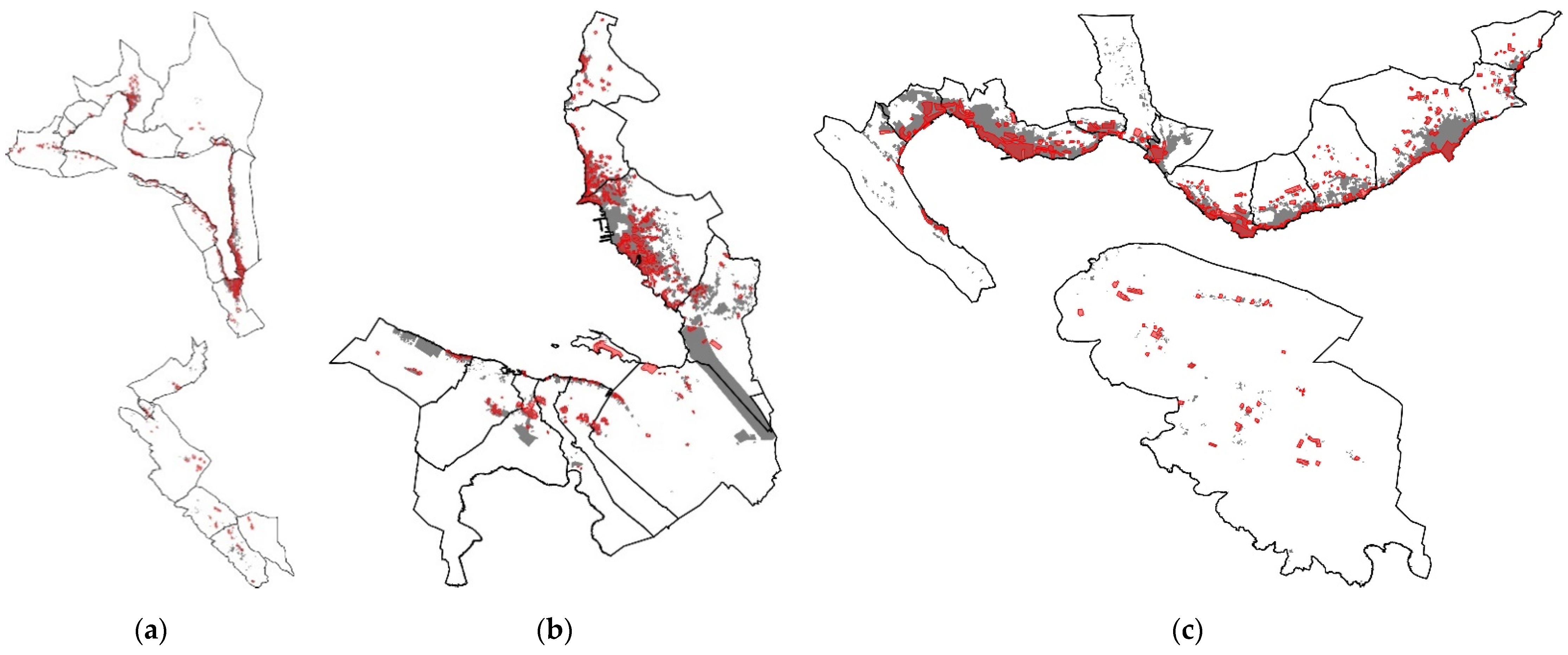
| Municipality | Area of the Coastal Settlements (ha) | Area of BL in the First Observed Period (ha) | Area of BL in the Second Observed Period (ha) | The Percentage of the Increase (%) |
|---|---|---|---|---|
| Kotor | 10,775 | 205 | 448 | 2.25% |
| Tivat | 3605 | 123 | 518 | 10.95% |
| Herceg Novi | 6399 | 252 | 641 | 6.08% |
| Σ | 20,779 | 580 | 1607 | 4.94% |
| Abbreviation | Meaning | |||||||||
|---|---|---|---|---|---|---|---|---|---|---|
| A | Increase /decrease in the area of built-up land of the coastal municipality, in relation to the area of the municipality, observed over two periods, expressed in percentage | |||||||||
| B | Increase/decrease in the area of built-up land of the coastal settlement, in relation to the area of the municipality, observed over two periods, expressed in percentage | |||||||||
| C1 | Increase/decrease in the area of built-up land within the coastal zone of the municipality (up to 100 m distance from the coastline to the mainland), in relation to the area of the municipality, observed over two periods, expressed in percentage | |||||||||
| D1 | Increase/decrease in the area of built-up land within the coastal zone of the settlement (up to 100 m distance from the coastline to the mainland), in relation to the area of the settlement, observed over two periods, expressed in percentage | |||||||||
| C2 | Increase/decrease in the area of built-up land outside the coastal zone of the municipality, in relation to the area of the municipality, observed over two periods, expressed in percentage | |||||||||
| D2 | Increase/decrease in the area of built-up land outside the coastal zone of the settlement, in relation to the area of the municipality, observed over two periods, expressed in percentage | |||||||||
| E1 | Increase/decrease in the area of built-up land in the municipality up to 100 m above sea level, in relation to the area of the municipality, observed over two periods, expressed in percentage | |||||||||
| F1 | Increase/decrease in the area of built-up land in the settlement up to 100 m above sea level, in relation to the area of the settlement, observed over two periods, expressed in percentage | |||||||||
| E2 | Increase/decrease in the area of built-up land in the municipality of 100 m above sea level, in relation to the area of the municipality, observed over two periods, expressed in percentage | |||||||||
| F2 | Increase/decrease in the area of built-up land in the settlement of 100 m above sea level, in relation to the area of the settlement, observed over two periods, expressed in percentage | |||||||||
| Coastal settlement | A | B | C1 | D1 | C2 | D2 | E1 | F1 | E2 | F2 |
| Kotor municipality | ||||||||||
| Kotor | +2.25 | +37.06 | +4.63 | +29 | +1.91 | +8.05 | +4.45 | −4.94 | +0.05 | 0 |
| Bigova | +13.04 | +9.28 | +3.75 | +13.03 | 0 | |||||
| Glavatići | −0.27 | +0.39 | −0.65 | +0.12 | −0.39 | |||||
| Gornji Orahovac | −0.08 | 0 | −0.08 | 0 | −0.07 | |||||
| Dobrota | +9.87 | +4.50 | +5.36 | +9.82 | +0.04 | |||||
| Donji Morinj | 0 | +0.62 | -0.62 | +0.82 | −0.82 | |||||
| Donji Orahovac | +23.93 | +10.97 | +12.95 | +23.93 | 0 | |||||
| Donji Stoliv | +17.08 | +17.08 | 0 | +15.40 | +1.68 | |||||
| Dražin Vrt | +2.13 | +5.60 | −3.46 | +2.13 | 0 | |||||
| Zagora | −0.50 | 0 | −0.50 | 0 | −0.50 | |||||
| Kostanjica | +0.96 | +2.36 | −0.41 | +1.25 | −0.30 | |||||
| Krimovica | +1.91 | +0.06 | +2.28 | +0.21 | +2.13 | |||||
| Lipci | +4.97 | +4.61 | +0.35 | +4.97 | 0 | |||||
| Lješevići | +1.38 | 0 | +1.37 | +1.30 | +0.07 | |||||
| Muo | +6.46 | +5.69 | +0.70 | +6.45 | 0 | |||||
| Perast | +0.27 | +0.25 | +0.01 | +0.25 | +0.01 | |||||
| Prčanj | +4.91 | +3.71 | +1.19 | +4.91 | 0 | |||||
| Risan | +2.90 | +1.04 | +1.84 | +3.59 | −0.69 | |||||
| Strp | +0.52 | +0.78 | −0.26 | +0.52 | 0 | |||||
| Višnjevo | −0.77 | +0.01 | −0.78 | +0.01 | −0.78 | |||||
| Škaljari | +10.55 | +1.37 | +9.19 | +9.83 | +0.73 | |||||
| Tivat municipality | ||||||||||
| Coastal settlement | A | B | C1 | D1 | C2 | D2 | E1 | F1 | E2 | F2 |
| Tivat | +10.95 | +27.87 | +1.86 | +6.30 | +7.22 | +23.58 | +8.92 | +29.18 | +0.16 | +0.71 |
| Bogišići | −0.43 | −0.98 | +0.56 | −0.75 | +0.33 | |||||
| Gošići | +3.05 | +0.64 | +2.40 | +1.99 | +1.05 | |||||
| Donja Lastva | +9.99 | +3.61 | +6.37 | +10.35 | −0.34 | |||||
| Đuraševići | +5.41 | −0.09 | +5.50 | +5.37 | +0.03 | |||||
| Krašići | +10.00 | +4.52 | +5.47 | +9.57 | +0.42 | |||||
| Lepetani | +1.77 | +2.50 | −0.72 | +1.81 | −0.04 | |||||
| Milovići | +2.83 | +0.39 | +2.42 | +3.82 | −1.00 | |||||
| Mrčevac | +29.32 | +1.74 | +27.53 | +29.15 | +0.12 | |||||
| Radovići | −0.87 | +0.03 | −0.90 | −1.26 | +0.39 | |||||
| Herceg Novi municipality | ||||||||||
| Coastal settlement | A | B | C1 | D1 | C2 | D2 | E1 | F1 | E2 | F2 |
| Herceg Novi | +6.08 | +36.73 | +2.98 | −0.42 | +10.80 | +37.16 | +13.75 | +32.70 | +0.33 | +4.00 |
| Baošići | +9.85 | +2.47 | +7.37 | +10.31 | −0.47 | |||||
| Bijela | +12.22 | +2.35 | +9.87 | +4.11 | +0.76 | |||||
| Đenovići | +14.85 | +5.36 | −2.84 | +15.70 | −0.85 | |||||
| Đurići | +3.98 | +2.26 | +1.71 | +5.06 | −1.08 | |||||
| Igalo | +42.40 | +5.77 | +36.61 | +42.39 | 0 | |||||
| Jošice | +5.25 | +4.56 | +3.89 | +8.83 | −0.37 | |||||
| Kumbor | +11.28 | +5.82 | +6.72 | +11.68 | −0.40 | |||||
| Luštica | +0.01 | +0.09 | −0.08 | +0.18 | −0.16 | |||||
| Meljine | +15.56 | +2.11 | +13.44 | +15.56 | 0 | |||||
| Provodina | +4.52 | +1.07 | +3.44 | +3.77 | +0.73 | |||||
| Sasovići | +3.59 | +0.84 | +2.75 | +1.44 | +2.15 | |||||
| Zelenika | +27.13 | +6.54 | +20.59 | +27.13 | 0 | |||||
| Kotor Municipality | |||||||||
|---|---|---|---|---|---|---|---|---|---|
| Kotor | 1.80 | Bigovo | 1.50 | Glavatići | 2.17 | G. Orahovac | 1.05 | Dobrota | 1.89 |
| Donji Morinj | 1.50 | D. Orahovac | 1.66 | Donji Stoliv | 1.36 | Dražin Vrt | 1.19 | Zagora | 1.55 |
| Kostanjica | 1.28 | Krimovica | 2.25 | Lipci | 1.24 | Lješevići | 1.34 | Muo | 1.55 |
| Perast | 1.42 | Prčanj | 1.92 | Risan | 3.36 | Strp | 1.20 | Višnjevo | 2.44 |
| Škaljari | 1.39 | ||||||||
| Tivat municipality | |||||||||
| Tivat | 2.92 | Bogišići | 4.90 | Gošići | 2.62 | D. Lastva | 1.41 | Đuraševići | 1.20 |
| Krašići | 1.36 | Lepetani | 1.47 | Milovići | 2.07 | Mrčevac | 1.64 | Radovići | 2.53 |
| Herceg Novi municipality | |||||||||
| Herceg Novi | 1.65 | Baošići | 1.61 | Bijela | 1.45 | Đenovići | 1.70 | Đurići | 1.21 |
| Igalo | 1.32 | Jošice | 1.60 | Kumbor | 1.60 | Luštica | 4.39 | Meljine | 1.12 |
| Provodina | 1.44 | Sasovići | 1.16 | Zelenika | 1.74 | ||||
| Quotient | Ratio (Formula) |
|---|---|
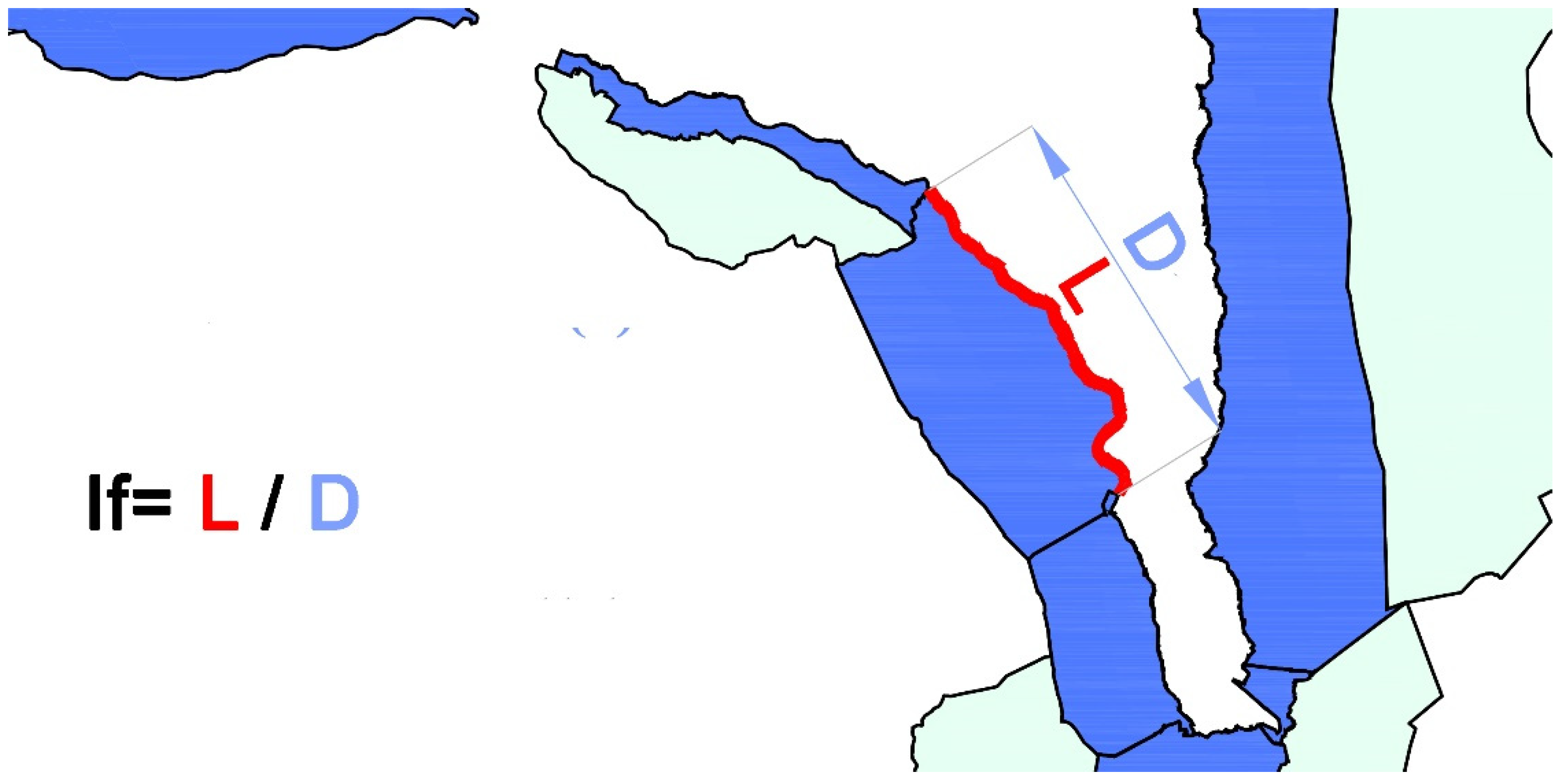
| Maritimity | Length of developed seashore (km)/Area of municipality (km2) |
| Indentation | Length of developed shore (km)/Linear length of the shore (km) |
| Swimming Beach | Length of the shore used for swimming (km)/Length of developed shore (km) |
| Littotality | Area of the shore belt (500 m) (km2)/Area of municipality (m2) |
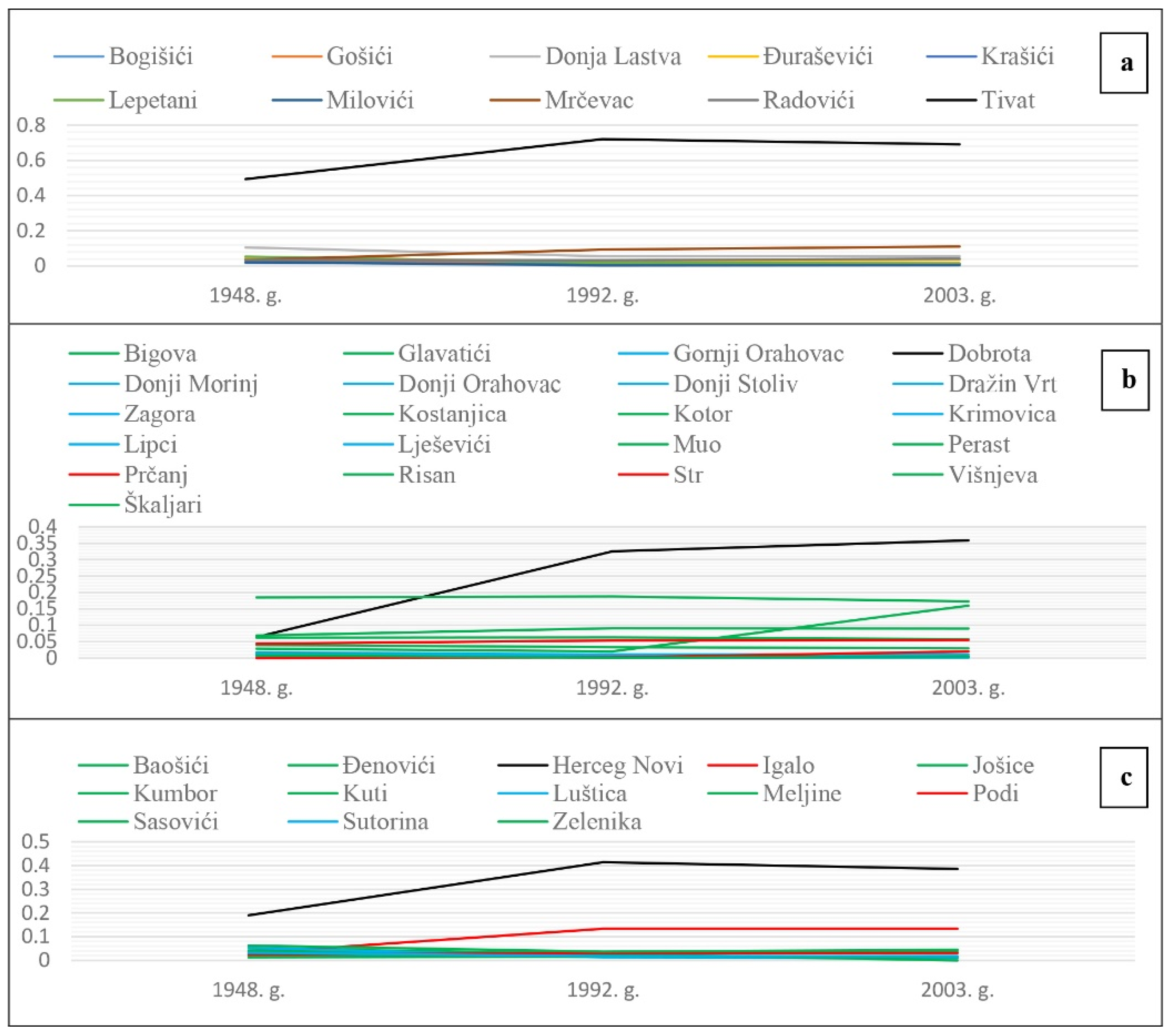
| Number of Inhabitants in the Settlement in Relation to the Municipality | Built-Up Area in Increase | Rest in the Spread of the Built-Up Area |
|---|---|---|
| No. of settlements with the largest number of inhabitants | 3 | / |
| No. of settlements with an increase in the number of inhabitants | 5 | / |
| No. of settlements with declining population | 17 | 4 |
| No. of settlements with rest no. inhabitants | 12 | 3 |
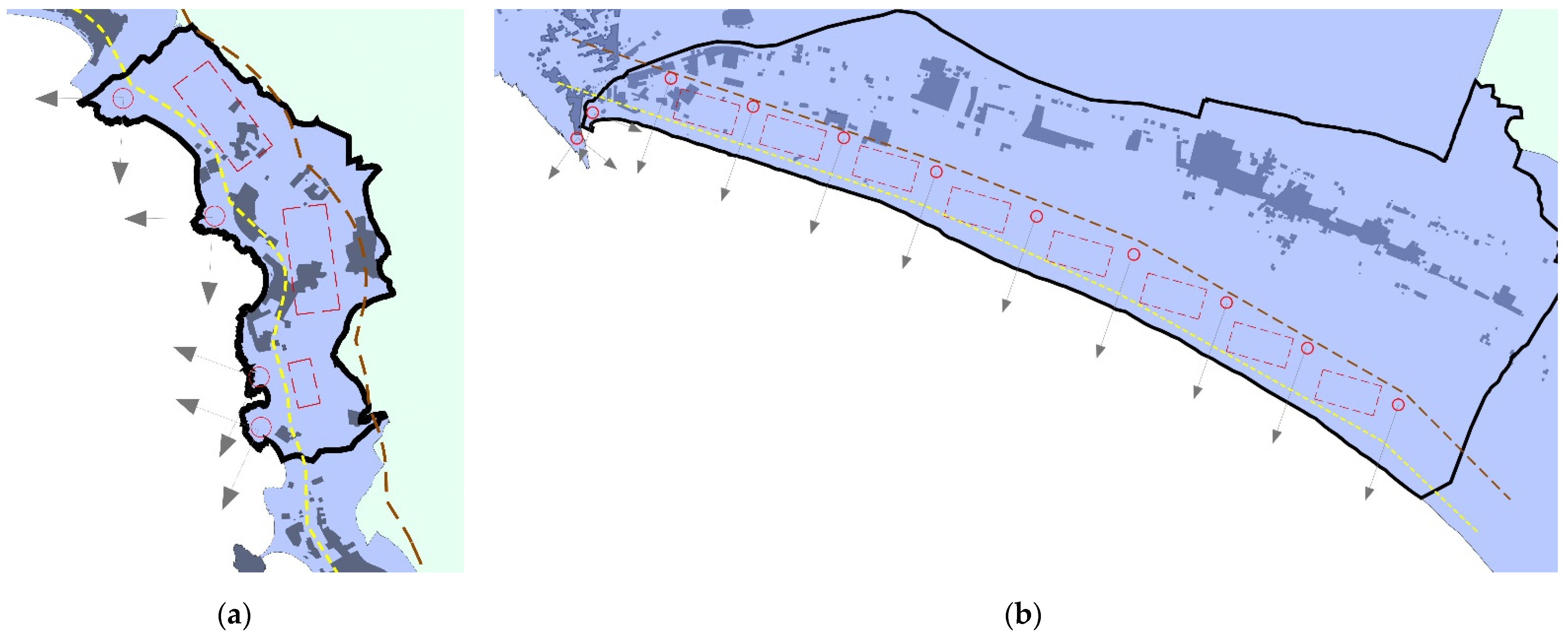
| Criteria | Distinctive Elements and Features of Coastal Settlements in Boka | Proposal for the Planned Development | Settlement/Part of a Settlement (Municipality) | ||||
|---|---|---|---|---|---|---|---|
| 1 | CNV; SUC | Nonbuilt part of a construction area | Unfit for construction due to geological and morphological characteristics | Agricultural development | Western part of Igalo (Herceg Novi) | ||
| 2 | CNV; SUC; EC | Terrain topography (slope) | Pine forest complex | Orientation (south-east) | Hotel accommodation | Pržna, Bigova (Tivat) | |
| Nonbuilt part of a construction area | Visual connection with the sea and the mainland | ||||||
| Terrain topography (flat terrain) | Olive groves | Beach accessibility | |||||
| 3 | CNV; SUC | Terrain configuration | Insolation | Construction of a tourist complex | Markov Rt, Prčanj (Kotor) | ||
| 4 | CNV | Connecting the area with the mountain and the sea | Necessary area for expanding the capacities | Health care-tourist center | Igalo (Herceg Novi) | ||
| Panoramic view of the Bay of Boka | Climatic conditions | ||||||
| 5 | CHC; SUC | Structure of a construction area: scattered | Proximity of the shore | Historical properties | Polycentric development of settlements | Luštica (Herceg Novi) | |
| Partially nonbuilt part of a construction area | Distinctive elements of cultivated landscape (olive groves) | ||||||
| 6 | CHC; SUC | Distinctive elements of cultivated landscape | Preservation of panoramas | Road construction | Đurići, Jošice, Lepetani (Herceg Novi-Tivat) | ||
| Distinctive elements of a cultural–historical area | |||||||
| 7 | CNV; SUC | Terrain topography | Insolation | Construction of a specific residential–tourist point | Morinj (Kotor) | ||
| Visual perception | |||||||
| Planning Models | Criteria for the Development of Coastal Settlements and the Existing Natural and Anthropogenic Features | Proposal for the Planned Development | Settlement/Part of a Settlement (Municipality) | |
|---|---|---|---|---|
| 1 | MOF; SUM | CNV (respecting terrain topography, insolation, climatic conditions, flora) | Retaining the basics of spatial organization | Lastva (Tivat) |
| SUC (reduction of road traffic) | ||||
| 2 | MOF; IM | CNV (better visual perception of the space, terrain morphology) | Construction of cable cars | Kotor, Muo, Donji Stoliv, Donji Orahovac, Perast (Kotor) |
| EC (expanding tourist offer) | ||||
| CNV (terrain topography, geomechanical characteristics, hydrogical features, climatic conditions) | ||||
| SUC (population, spatial organization) | ||||
| 3 | IM; SUM; PPM | SUC (relieving road traffic) | Sustainable maritime and road traffic | Coastal Region of Montenegro and Boka Kotorska |
| CHC (preserving areas of historical significance) | ||||
| CNV (using natural resources) | ||||
| 4 | IM; EM; SUM | CHC (the existence of historical urban ensembles) | Urban patterns of the development of Boka | Boka Kotorska |
| CNV (nonbuilt part of a construction area) | ||||
| EC (developing new tourist centers) | ||||
| 5 | SUM; IM | CNV (terrain topography, proximity of the coastline, views) | Spatial organization of the center | Herceg Novi, Topla, Igalo, Savina (Herceg Novi) |
| CHC (the existence of a historic core) | ||||
| SUC (existing urban functions, traffic connections, expanding construction area) | ||||
| 6 | SUM; EM; IM | EC (the existence of a large industrial complex, identifying other activities suitable for the area) | Spatial organization of the center | Bijela (Herceg Novi) |
| CNV (terrain topography, views) | ||||
| SUC (promenades, road segregation, ratio of green areas and built-up construction area) | ||||
| 7 | SUM; EM; IM | EC (the existence of an industrial plant) | Spatial organization of the center (primary nucleus) | Tivat, Seljanovo (Tivat) |
| SUC (uncontrolled expansion of a construction area, linear road traffic, transverse pedestrian promenades, supplementation of public facilities in the coastal zone) | ||||
| CNV (terrain topography, views) | ||||
| 8 | SUM; EM; IM; PPM | CNV (orientation, terrain topography, views) | Spatial organization of the municipality | Kotor, Dobrota, Škaljari, Muo (Kotor) |
| CHC (constructions of historical significance, forms of old architecture) | ||||
| SUC (segregation of busy traffic, defining reserve zones, determining location of tourist and housing capacities) | ||||
| EC (the existence of an industrial plant) | ||||
| 9 | SUM; IM; EM; PPM | CHC (historic core) | Spatial organization of the center | Kotor, Dobrota, Škaljari (Kotor) |
| SUC (exemption from construction and road traffic along the coastline, forming a new urban center) | ||||
| CNV (spatial possibilities of the area, topography of the terrain, views, activation of urban greenery) | ||||
| EC (the existence of an industrial plant) | ||||
| 10 | SUM; IM; EM | CHC (the existence of constructions of historical significance) | Spatial organization of the center | Tivat (Tivat) |
| SUC (uncontrolled expansion of a construction area, defining reserve zones, segregation of traffic, strengthening the street front and promenade) | ||||
| EC (the existence of an industrial plant) | ||||
| 11 | PPM; EM | CNV (using topography to organize health care tourism facilities, for agriculture; unsuitable terrain for green areas) | Alternative spatial organizations in the municipality | Igalo, Provodina (Herceg Novi) |
| CHC (revitalization of old settlements by conversion into health care tourism) | ||||
| EC (development thresholds and economic viability of the expansion of the construction area) | ||||
| SUM | SUC (segregation of the construction areas of the coastal settlements) | |||
| SUM | CNV (using topography for the construction of a marina, views) | |||
| SUC (enhancing tourist content, segregation of the functions, construction phases) | ||||
| Models | Advantages/Disadvantages |
|---|---|
| Model I (Igalo as a multidirectional center): | Advantages: economically favorable expansion of the construction area; health care tourism based on the revitalization of old settlements; use of terrain topography for health care tourism facilities; use of terrain topography for agriculture; use of construction site inconveniences for green areas. |
| Model II (Igalo as the suburb of Herceg Novi): | Advantages: separation of the construction area of coastal settlements of Herceg Novi and Igalo. Disadvantages: construction of Sutorinsko polje (unfavorable for construction); combining the functions of tourism and health care with housing; losing views of the sea. |
| Model III (Igalo as a new tourist center): | Advantages: formation of the marina and use of terrain topography; staged construction; differentiation of functions; expansion of tourist contents; traffic improvement. Disadvantages: specific type of structures and activities. |
| Model II (Modela III variant): | Advantages: as in Model III. Disadvantages: segregation; possible endangerment of the natural environment. |
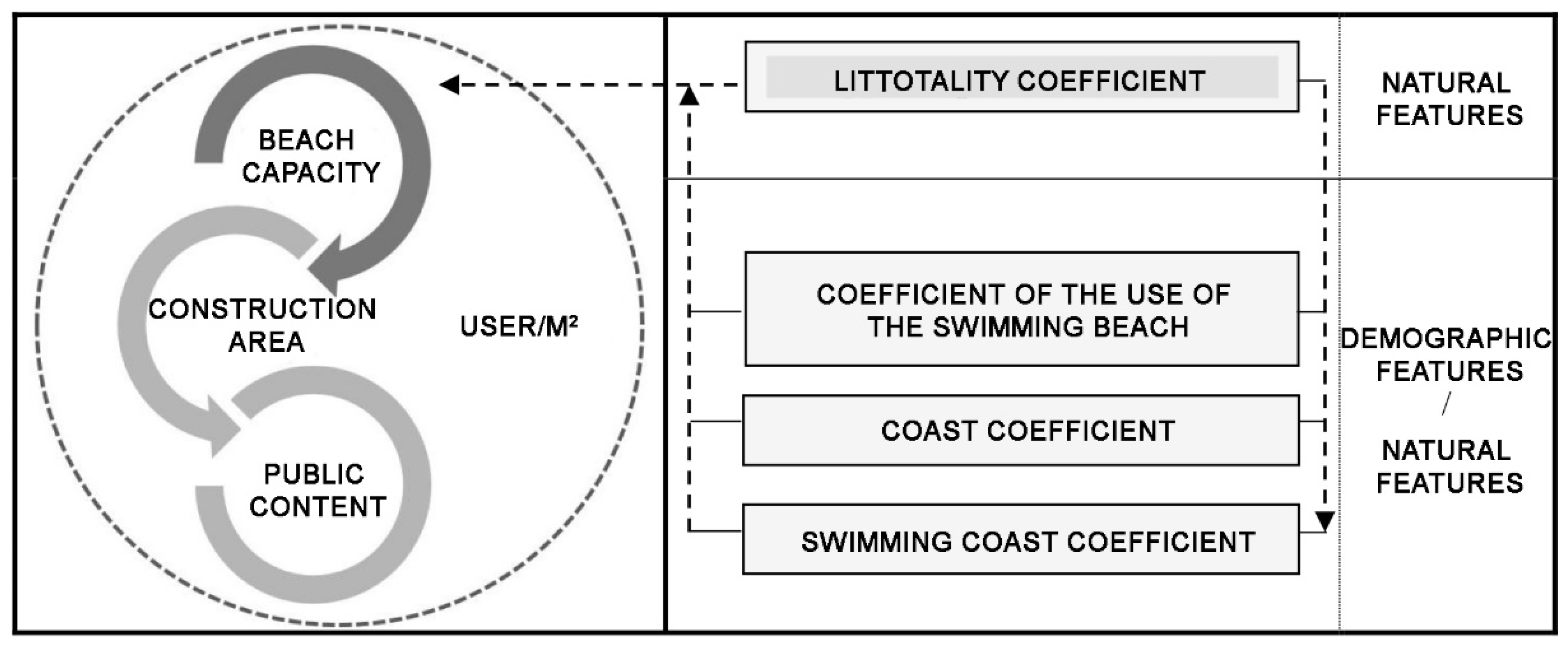
| Coefficients/Capacities | Connection between Natural and Anthropogenic Characteristics | |
|---|---|---|
| Coast coefficients | Maritimeness | Length of the developed coast (km)/Area of the municipality (km2) |
| Indentation | Length of the developed coast (km)/Aerial length of the coast (km) | |
| Beach for swimming | Length of coast suitable for swimming (km)/Length of developed coast (km) | |
| Coastal capacities | Use of the beach for swimming | Length of coast suitable for swimming (m)/Number of tourist beds |
| Use of the coast | Number of tourists (permanent and excursion)/Length of the developed coast (m) | |
| Coefficient of littotality | Area of the coastal zone (500 m) (km2)/Area of the municipality (m2) | |
| Coast Indentation Index (If) | ||
|---|---|---|
| Influence on a Coastal Settlement | If = → 1 (Closer to the Value of 1.00) | If = ← 1 (Further from the Value of 1.00) |
| Traffic system: | Road traffic dislocation; segregation of road traffic from pedestrian traffic; shaping roads along the coastline. | Possibility of cross-linking the coastline and the construction area through pedestrian traffic. |
| Visual perception: | Smaller angle of the visual field; forming artificial structures on the coastline. | Greater potential for using the natural dynamics of the coastline. |
Publisher’s Note: MDPI stays neutral with regard to jurisdictional claims in published maps and institutional affiliations. |
© 2022 by the authors. Licensee MDPI, Basel, Switzerland. This article is an open access article distributed under the terms and conditions of the Creative Commons Attribution (CC BY) license (https://creativecommons.org/licenses/by/4.0/).
Share and Cite
Savić, S.; Mašanović, N.; Bajić Šestović, J. Planning Criteria and Models for the Development of Urban Structures of Coastal Settlements of Boka Kotorska. Sustainability 2022, 14, 9467. https://doi.org/10.3390/su14159467
Savić S, Mašanović N, Bajić Šestović J. Planning Criteria and Models for the Development of Urban Structures of Coastal Settlements of Boka Kotorska. Sustainability. 2022; 14(15):9467. https://doi.org/10.3390/su14159467
Chicago/Turabian StyleSavić, Sanja, Nevena Mašanović, and Jelena Bajić Šestović. 2022. "Planning Criteria and Models for the Development of Urban Structures of Coastal Settlements of Boka Kotorska" Sustainability 14, no. 15: 9467. https://doi.org/10.3390/su14159467
APA StyleSavić, S., Mašanović, N., & Bajić Šestović, J. (2022). Planning Criteria and Models for the Development of Urban Structures of Coastal Settlements of Boka Kotorska. Sustainability, 14(15), 9467. https://doi.org/10.3390/su14159467