
Changes in Contemporary Form in Gangneung City through Cadastral Data Analysis and Application of the Spatial Politics Concept


Abstract
:1. Introduction
2. Review of Previous Studies and Theories
2.1. Review of Previous Studies
2.1.1. Research on Urban Tissue and Urban Form
2.1.2. Studies Related to Gangneung City
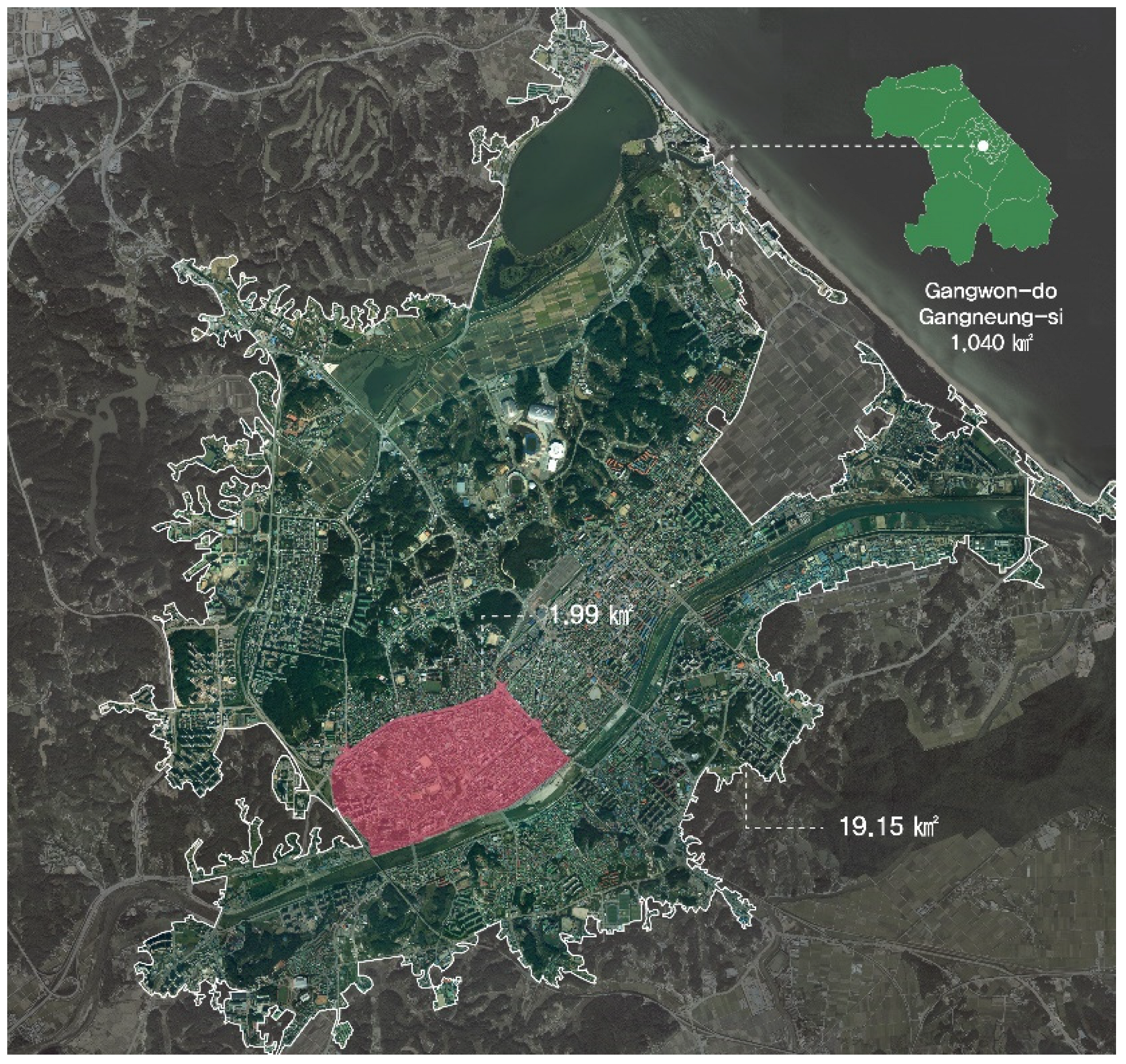
2.2. Outstanding Issues of Small and Medium Regional Cities; Study of the Development History and the Significance of Gangneung City
2.3. The Necessity of Applying the Concept of Spatial Politics and Classification of Gangneung City by Period
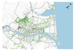
3. Analysis of Gangneung City’s Urban Formation before Modernization
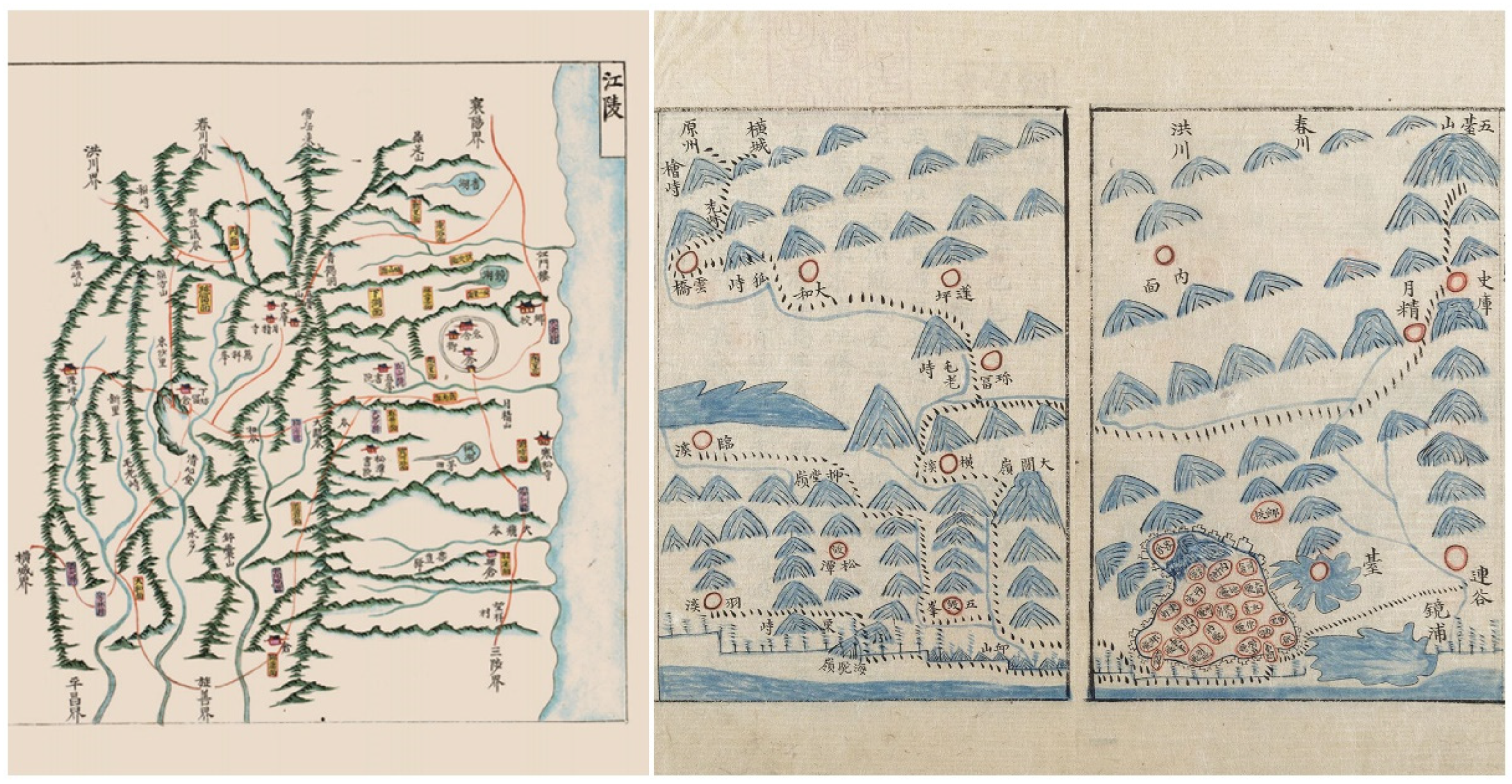
3.1. Historical Development of Ancient Gangneung
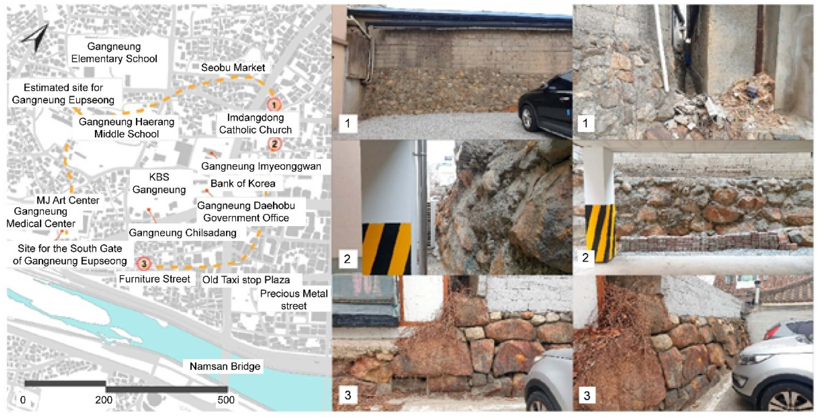
3.2. Geographical Characteristics of “GangneungEupseong” and Changes in the Urban Structure of Gangneung City during the Japanese Colonial Period
4. Characteristics of Changes in Urban Tissue by Period of Urbanization in Gangneung City
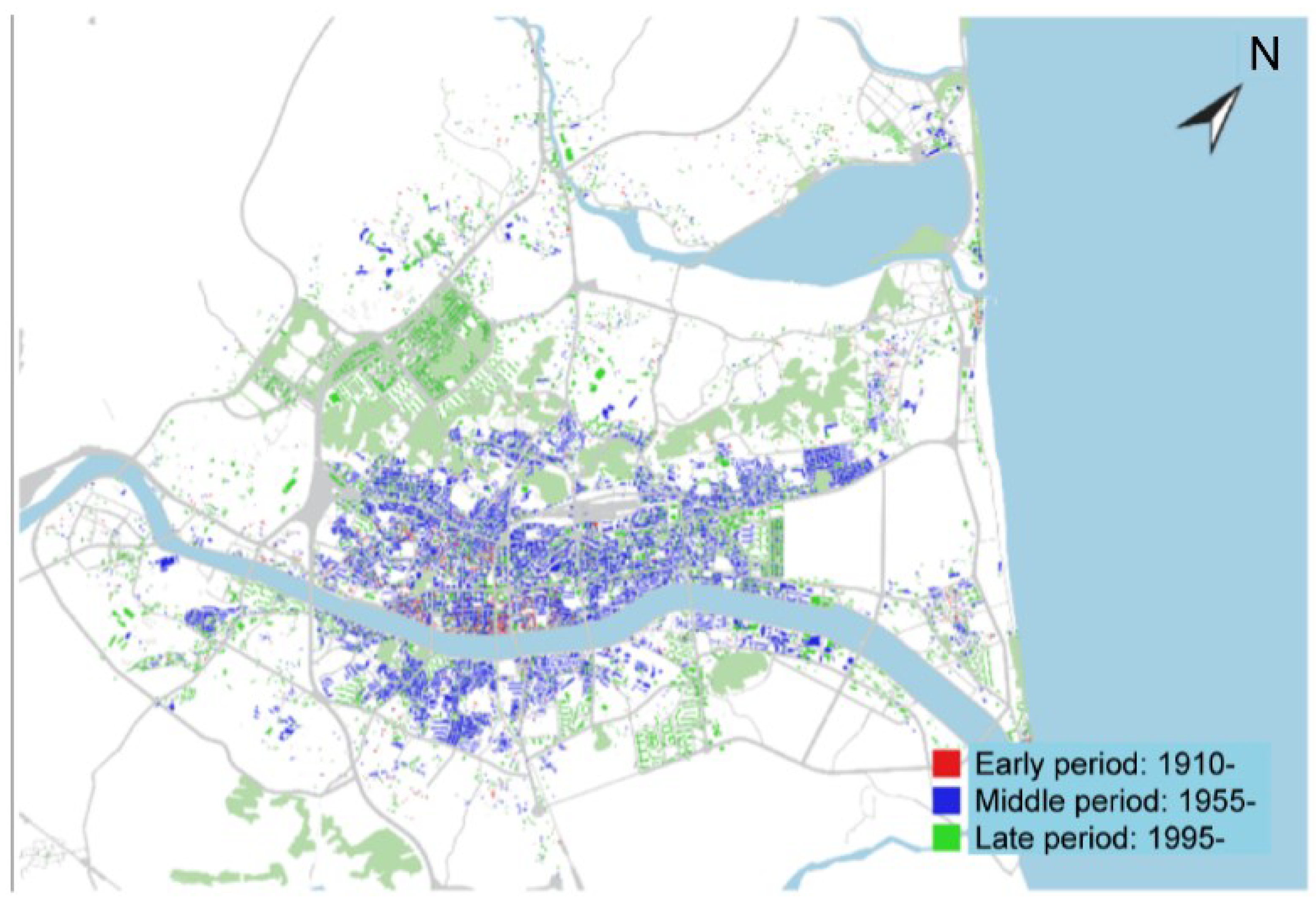
4.1. First Period: 1910–1954 (Gangneung-eup Period)
4.2. Second Period: 1955–1994 (Gangneung City)
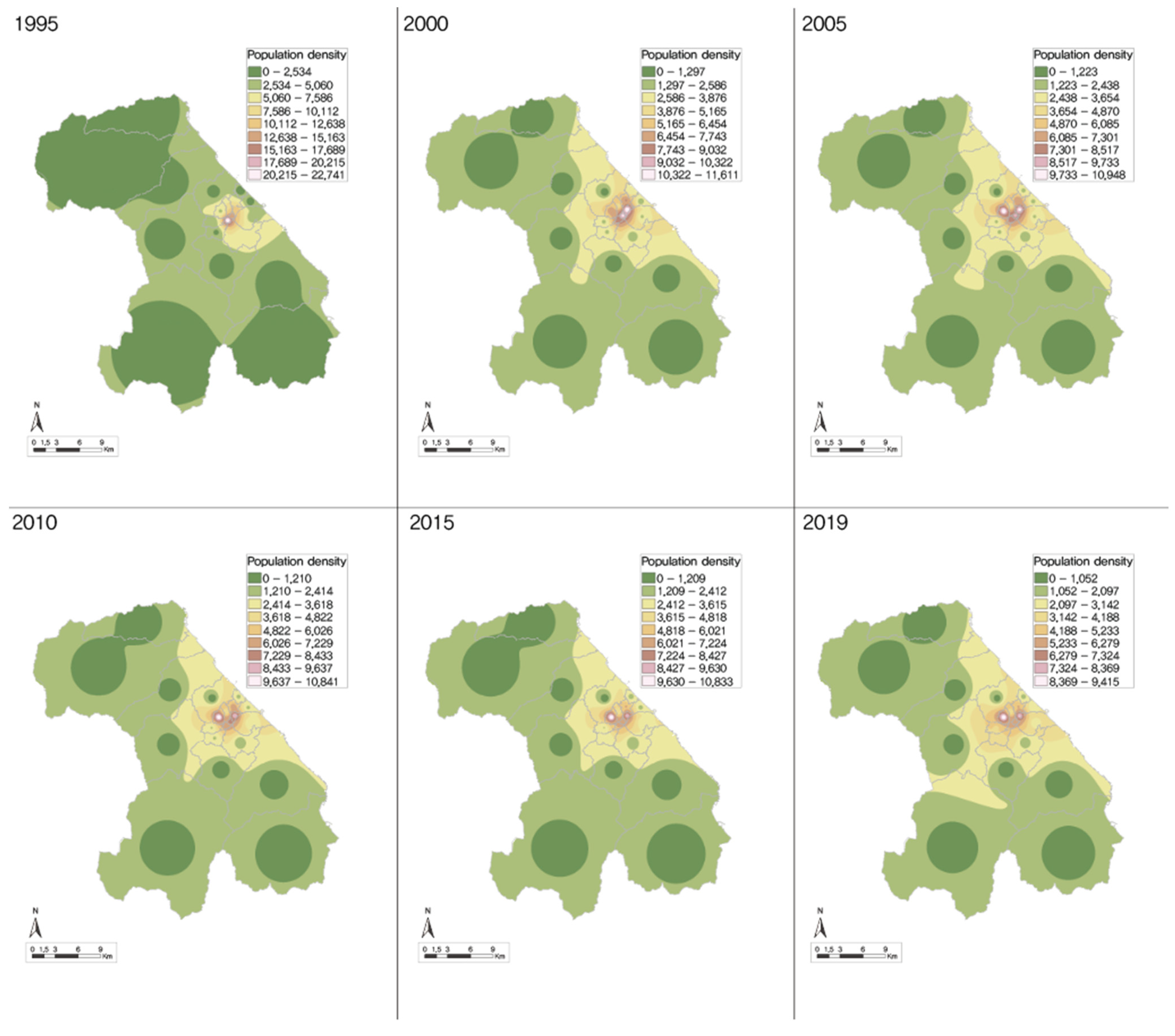
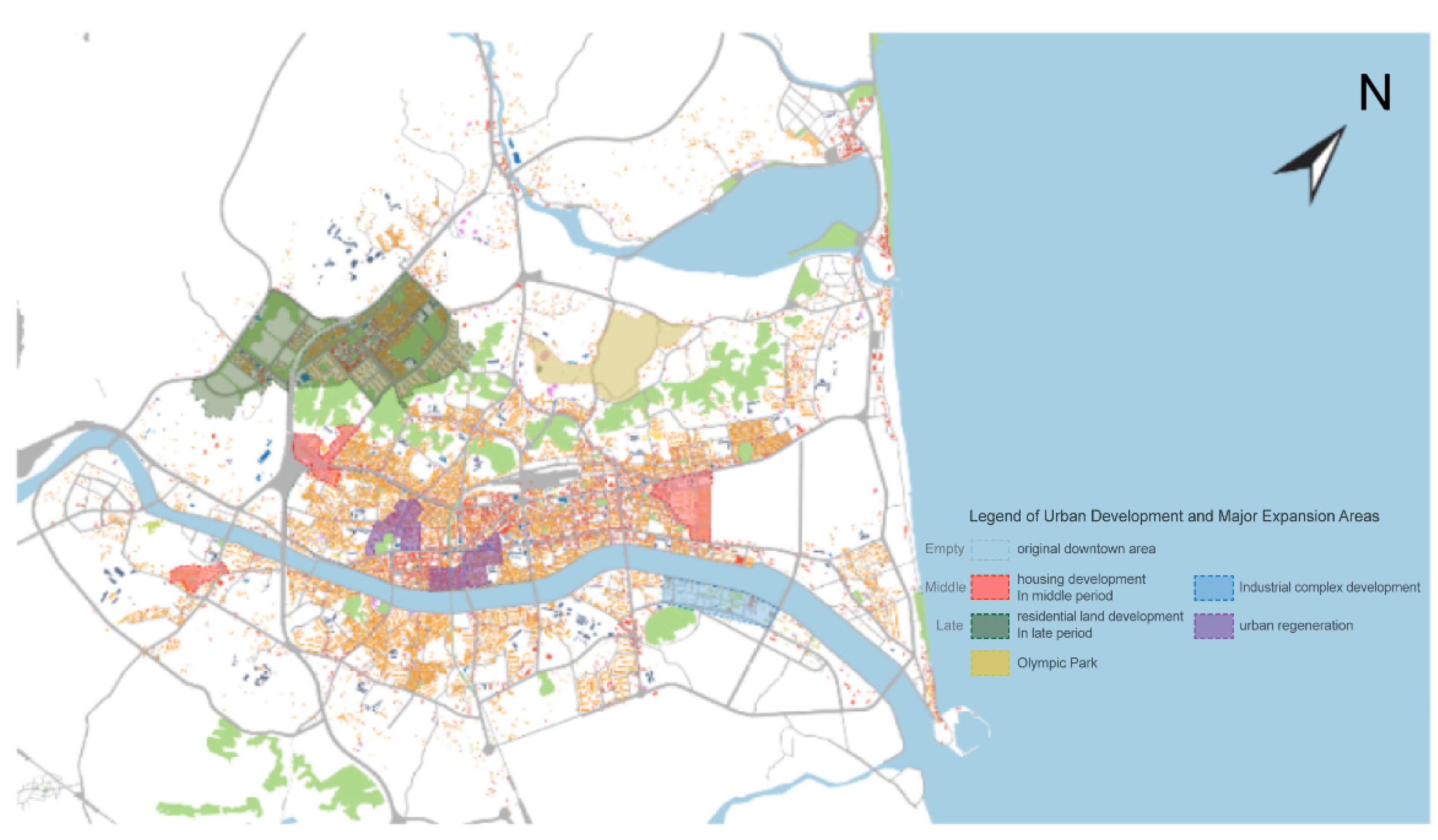
4.3. Third Period: 1995–Present (Gangneung City and Myeongju-gun Integration Period)
5. Characteristics of Changes in the Built Environment by Period of Urbanization
5.1. First Period: 1910–1954s (Gangneung-eup Period)
5.2. Second Period: 1955–1994 (Gangneung City)
5.3. Third Period: 1995–Present (Gangneung City and Myeongju-gun Integration Period)
6. Results and Discussion
6.1. Results
6.2. Limitations and Recommendations for Future Studies
7. Conclusions
Funding
Institutional Review Board Statement
Informed Consent Statement
Data Availability Statement
Conflicts of Interest
References
- Chung, H.; Hong, C. A Study on the Possibility of Gangwon Province’s Extinction. J. Soc. Sci. 2018, 57, 3–25. [Google Scholar] [CrossRef]
- Kim, M.; Lee, J. Gangwon-do Local Governments’ Decline Analysis. GRI Rev. 2019, 71, 125–150. Available online: https://www.kci.go.kr/kciportal/ci/sereArticleSearch/ciSereArtiView.kci?sereArticleSearchBean.artiId=ART002500752 (accessed on 3 February 2022).
- Welcome to Gangneung City. Available online: https://gn.go.kr (accessed on 3 March 2022).
- Park, H. A Study on Contemporary Values of Historical Cities through Spatial Political Theory. Ph.D. Thesis, Department of Architecture, Hongik University, Seoul, Korea, 2009. [Google Scholar]
- Park, H. A Study on Changes in Contemporary and Modern Urban Forms through Analysis of Indication Data of Samcheok-City. J. Reg. Assoc. Archit. Inst. Korea 2020, 95, 27–38. [Google Scholar]
- Jung, R. The Implementation of a Digital Cadastral Archiving Systems Based on Spatial Data Infrastructure. Ph.D. Thesis, Department of Geodetic Engineering, Kyungil University, Gyeongsan, Korea, 2010. [Google Scholar]
- Park, H.; Moon, S.W.; Kim, H.J. Basic Study for Urbanity Analysis of Small and Medium Cities in Yeongdong, Gangwon-do. In Proceedings of the Architectural Institute of Korea’s Spring Conference, Jeju, Korea, 14 October 2021; pp. 258–261. [Google Scholar]
- Burton, E.; Jenks, M.; Williams, K. The Compact City: A Sustainable Urban Form? 1st ed.; eBook; Routledge: London, UK, 1996; pp. 30–45. ISBN 9780203362372. [Google Scholar]
- Berghauser Pont, M.Y.; Haupt, P.A. Space, Density and Urban Form. Ph.D. Thesis, Department of Urbanism, Delft University of Technology, Delft, The Netherlands, 2009. [Google Scholar]
- Kwon, Y.; Shin, H. Economic Effects of Changes in Spatial Accessibility on Regional Tourism Expenditure Structure. J. Cadastre Land Inf. 2019, 49, 135–149. [Google Scholar] [CrossRef]
- Milder, J. Sustainable Urban Form. In Sustainable Urban Environments: An Ecosystem Approach; van Bueren, E., van Bohemen, H., Itard, L., Visscher, H., Eds.; Springer: Dordrecht, The Netherlands, 2011; pp. 263–284. [Google Scholar]
- Liu, Y.; Wu, J.; Yu, D.; Ma, Q. The Relationship between Urban Form and Air Pollution Depends on Seasonality and City Size. Environ. Sci. Pollut. Res. Int. 2018, 25, 15554–15567. [Google Scholar] [CrossRef] [PubMed]
- Mobaraki, O.; Mohammadi, J.L.; Zarabi, A. Urban Form and Sustainable Development: The Case of Urmia City. J. Geogr. Geol. 2012, 4, 1. [Google Scholar] [CrossRef]
- Conzen, M.P. The Study of Urban Form in the United States. Urban Morphol. 2001, 5, 3–14. [Google Scholar]
- Larkham, P.J. The Study of Urban Form in Great Britain. Urban Morphol. 2006, 10, 117–141. [Google Scholar]
- Lu, D. Remaking Chinese Urban Form. Modernity, Scarcity and Space, 1949–2005; Routledge: London, UK, 2006. [Google Scholar]
- Whitehand, J.W.R.; Gu, K. Research on Chinese Urban Form: Retrospect and Prospect. Prog. Hum. Geogr. 2006, 30, 337–355. [Google Scholar] [CrossRef]
- Park, H. A Study on the Usage Behavior of Pedestrian-Oriented Public Spaces and Regional Changes Using the Railway Site. J. Korea Urban Geogr. Soc. 2020, 21, 139–158. [Google Scholar]
- Park, H. A Basic Study on the Urban Forms of Small and Medium Cities in Gangwon Area. J. Urban Des. Inst. Korea 2021, 22, 117–136. [Google Scholar] [CrossRef]
- Park, H. A Study on Urban Tissue Characteristics and Value of Historic City Buyeo. Archit. Inst. Korea 2012, 28, 199–212. [Google Scholar]
- Park, H.; Jeong, J.Y. A Study on the Value Setting Methodology of Historic City from the Urban Spatial Political Perspective. Archit. Institut. Korea 2009, 25, 301–312. [Google Scholar]
- Choi, D.H.; Kim, J.L.; Lee, G.J. Value of Urban Tissue as a Historical Environment. Collection of Dissertations. Korean Inst. Archit. 2005, 21, 181–188. [Google Scholar]
- Min, H.S. Evaluation of the Old Waterway Creation Project of the City Wall of Seoul after the Cheonggyecheon Restoration Project. Korean Reg. Sci. Assoc. Area Stud. 2014, 30, 71–88. [Google Scholar]
- Jeong, J.Y. A Study on the Characteristics of Urban Tissue in a Hilly Residential Area in Seoul. Seoul Inst. Seoul Stud. 2011, 12, 181–202. [Google Scholar]
- Shim, J.Y. A Poetic Review of “Jeonyegukgoseong” in Gangneung. Stud. Hum. Soc. Sci. 2015, 16, 191–220. [Google Scholar]
- Shim, J.Y. The Old City of Japan, an Investigation by KyoichiArimitsu. Res. Inst. Hum. 2016, 50, 209–232. [Google Scholar]
- Park, D.S. Historical and Administrative Changes of Gangneung. Stud. Hum. 2004, 7, 129–184. [Google Scholar]
- Park, M.H. A Study on Modern Architecture in Gangneung; Samcheok University Graduate School Paper: Samcheok City, Korea, 2005. [Google Scholar]
- Lim, D.I. Analysis of Spatial Structure Change in Gangneung City by Urban Development. J. Reg. Stud. Develop. 2010, 10, 99–128. [Google Scholar]
- Yeo, H. Rationalizing Community Policy for Korean Small and Medium-Sized Cities’ Slum Regeneration. 2013. Available online: www.auri.re.kr/gallery.es?mid=a20501000000&bid=0007&list_no=1098&act=view (accessed on 7 December 2021).
- Byun, S.P.; Kim, D.G.; Cha, E.H.; Lee, H.R. A Study on the Development Direction by Type for the Vitalization of Local Small and Medium Cities; Korea Research Institute for Human Settlements: Yeongi-gun, Korea, 2015. [Google Scholar]
- Lee, D.H. Direction of the Shape of Gangneung City and Its Challenges in the Future. J. Indust. Technol. Res. Inst. 1991, 6, 1–14. [Google Scholar]
- Yoon, J.H.; Jung, M.G. Measures for Revitalizing Tourism Development in the East Coast Region: Focusing on Goseong, Sokcho, Yangyang, and Gangneung. J. Tour Manag. Res. 2008, 12, 44–70. Available online: http://www.riss.kr (accessed on 10 November 2021).
- Kim, H.S. A Study on Fortresses in Gangneung Region Kwandong University Graduate School Paper. 1999. Available online: http://www.riss.kr/link?id=T7730149 (accessed on 19 December 2021).
- Gangneung City Cadastral Data. Original Cadastral Map. 1933. Available online: https://www.ngii.go.kr/kor/main.do (accessed on 31 August 2021).
- Gangneung City Cadastral Data. Original Cadastral Map. 1915. Available online: https://www.ngii.go.kr/kor/main.do (accessed on 31 August 2021).
- Gangneung Cultural Center. Jeil Gangneung, Which Was Established by Sweat; Gangneung Cultural Center: Gangneung City, Korea, 2005. [Google Scholar]
- Gangneung City History Compilation Committee. Gangneung City History; Gangneung City History Compilation Committee: Gangneung City, Korea, 1996. [Google Scholar]
- Heo, W.M. Lake Water, Gyeongpo. Quality and Water Environment Management Plan. Rivers Cult. 2013, 9, 31–38. [Google Scholar]
- Korea Research Institute for Local Administration. Urban-Rural Complex City: Institutional Analysis and Development Direction. Available online: https://www.nl.go.kr (accessed on 2 August 2021).

| Category | Content |
|---|---|
| Research content | Morphological development history of the urban architecture of Gangneung City. Urban morphology based on flow over time in terms of spatial politics. |
| Spatial scope | Main city center with a focus on the original city center (first). Central area of Gangneung City (second). |
| Research method | Classification of the modern and contemporary history of Gangneung City through the concept of spatial politics by period. Collection and analysis of geographic information, such as cadastral sources and cadastral maps, photos, and other data from the literature. Conduction of research by interviewing local residents, making drawings through field surveys, and utilizing GIS programs. |
| Researcher | Content |
|---|---|
| Park [19] | Analyzed the morphological development process of 18 cities and counties in Gangwon-do, focusing on cadastral data, derived characteristics, and presented implications. The study covered a vast geographic area and focused on deriving the tangible and morphological characteristics of small and medium cities in Gangwon-do. |
| Shim [25,26] | Conducted a literature review based on archaeological data concerning Jeonyegukgoseong in the original downtown area of Gangneung. The study suggested that it was located in the original downtown area of Gangneung City. |
| Park [28] | Cataloged the modern buildings of Gangneung City, classified their types, and discussed the implications, focusing on the built environment such as materials and structures. However, it omitted a significant number of target structures and provided a photo-centric modification. |
| Park [27] | Explained the historical development of Gangneung from ancient times to the late Joseon Dynasty. Described the transition process of administrative districts by era from a diachronic perspective. |
| Lim [29] | Analyzed the urban spatial structure of Gangneung City in terms of real estate and predicted future value through development patterns. |
| Time | Administrative Unit | Improvement in Physical Environment | Other Factors |
|---|---|---|---|
| 1940 | Gangneung-eup (6.540 km2) | City planning Set up the city planning street Set up a land readjustment district | Establishment of the Urban Planning Foundation |
| 1955 | Promoted to Gangneung City (expanded to 75.064 km2) | Water and sewage and road maintenance center Improvement of public health environment Maintenance of waterfront spaces such as beaches | Urban restoration development of the entire Gangneung City |
| 1965 | Urban planning maintenance with 13 items including land use survey, land price survey, building status survey, urban development history survey, etc. | Urban planning, development | |
| 1967 | Expansion as an urban planning redevelopment project Altitude conception of land use Redevelopment into residential, commercial, industrial, and green areas | ||
| 1995 | Gangneung-si and Myeongju-gun combined | Expansion of housing quantitative supply through housing site development (development of 6 complexes including Gyo-dong housing site development district) Redevelopment of the old original city center | Reorganization of urban planning through the introduction of sustainability |
| Category | Classification of Time via Aspects of Publication Politics | Characteristic (1) | Characteristic (2) | Subject of Analysis |
|---|---|---|---|---|
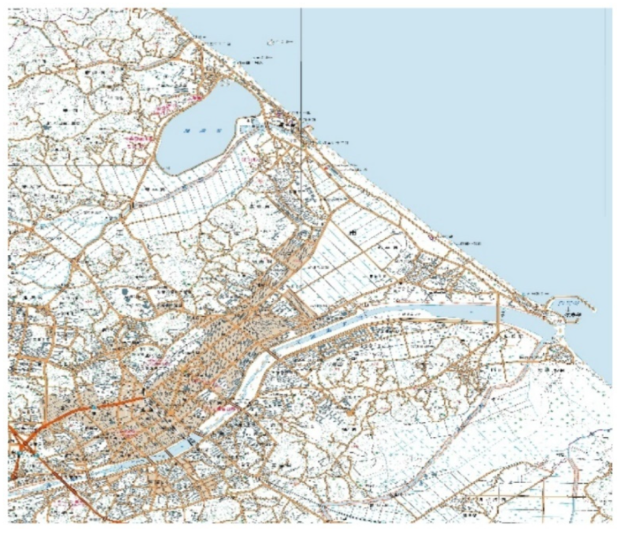
| Early primary stage: 1910–1954 | Gangneung-eup | Classification of periods in relation to changes in administrative districts. Strengthening its function as a historical city. Formative period of the basic structure of the city. | Change in the size of Gyeongpo Lake. Changes in the flow of Namdaecheon. Formation of a city road centered on the original city center. | Cadastral map and cadastral floor plan analysis. |
| Mid-secondary stage: 1955–1994 (inner expander) | Promotion of Gangneung-eup as a city | Establishment of urban functions such as administrative autonomy. Change in the center in the direction of Gyeongpodae. Change into a tourist city. | Change in the size of Gyeongpo Lake. Full-scale development of waterfront spaces, such as Gyeongpodae. | Cadastral floor plan analysis and GIS analysis. |
| Late tertiary stage: 1995–present (outer expander) | Integration of Gangneung City and Myeongju-gun | Strengthening the city’s character as a representative city of Yeongdong, Gangwon-do. Strengthening the city’s urban characteristics as a tourist city. | Continuous housing development and urban area expansion in Gangneung City’s suburbs. Seeking vitalization through downtown regeneration. | Cadastral floor plan analysis, GIS analysis, and numerical map analysis. |
| Category | Main Photo 1 | Main Photo 2 |
|---|---|---|
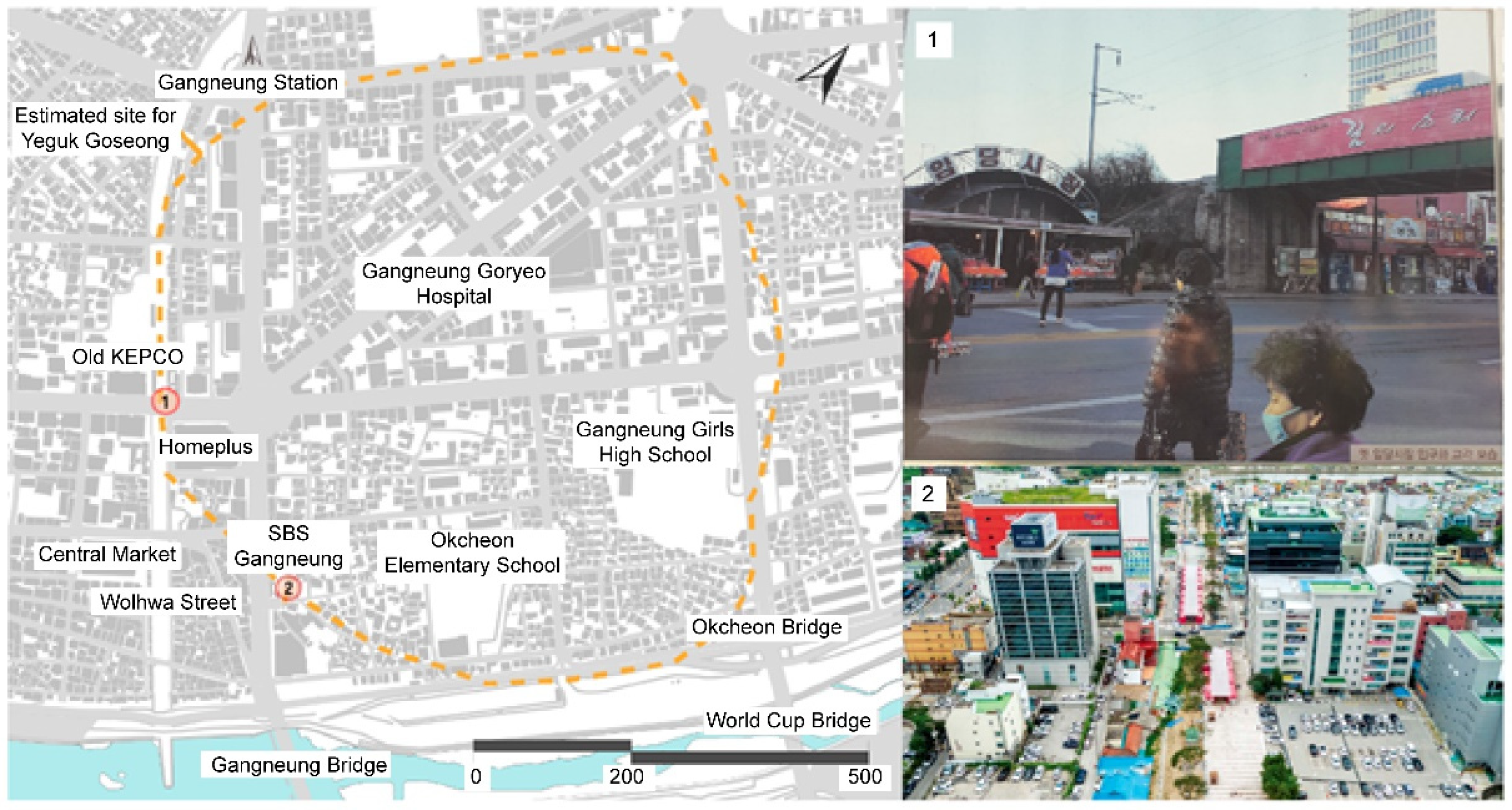
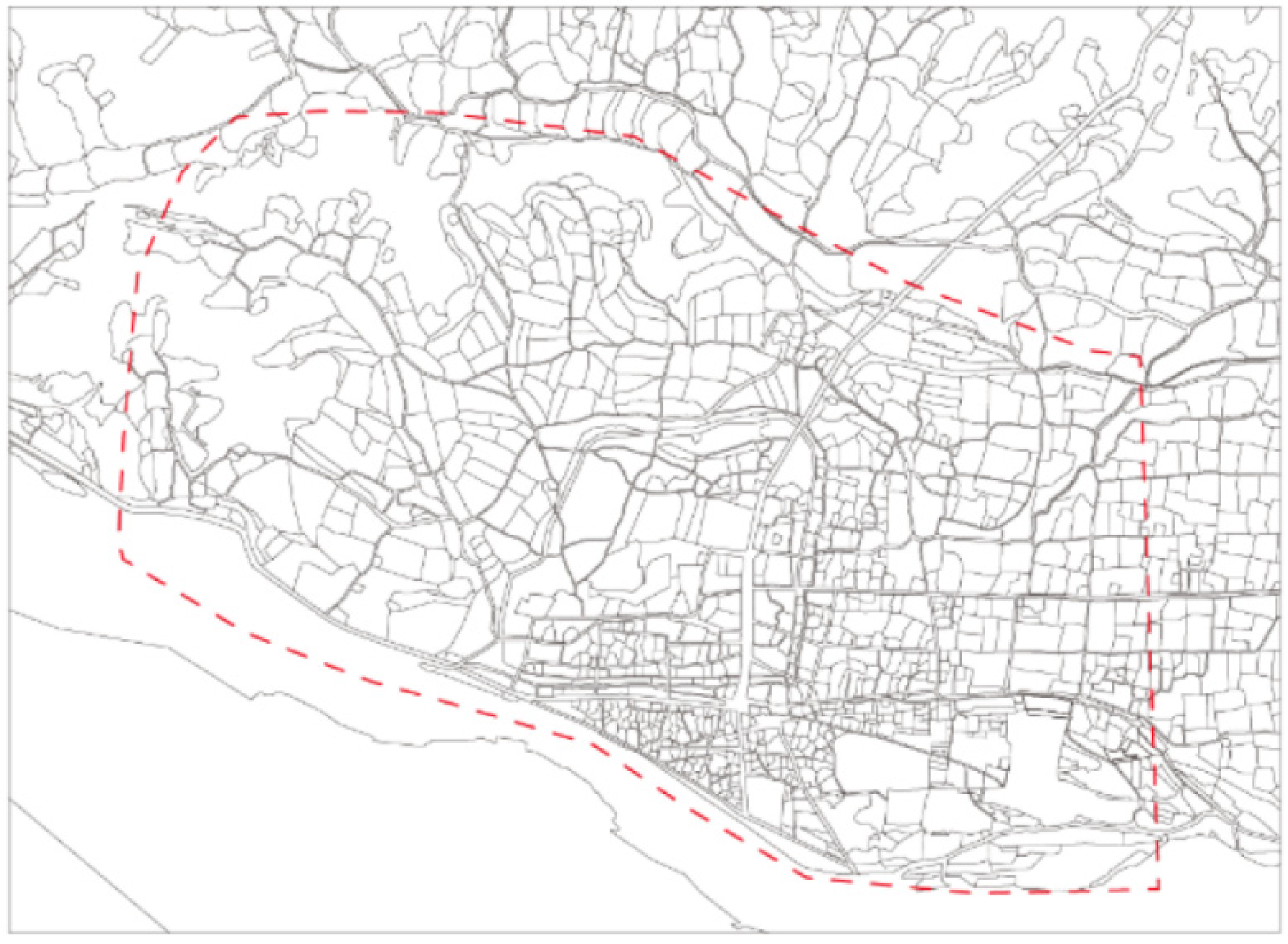
| View of Gangneung City |  | 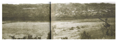 |
| Main roads | 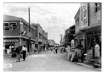 | 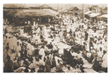 |
| Period | Floor Plan Analysis | Characteristics |
|---|---|---|
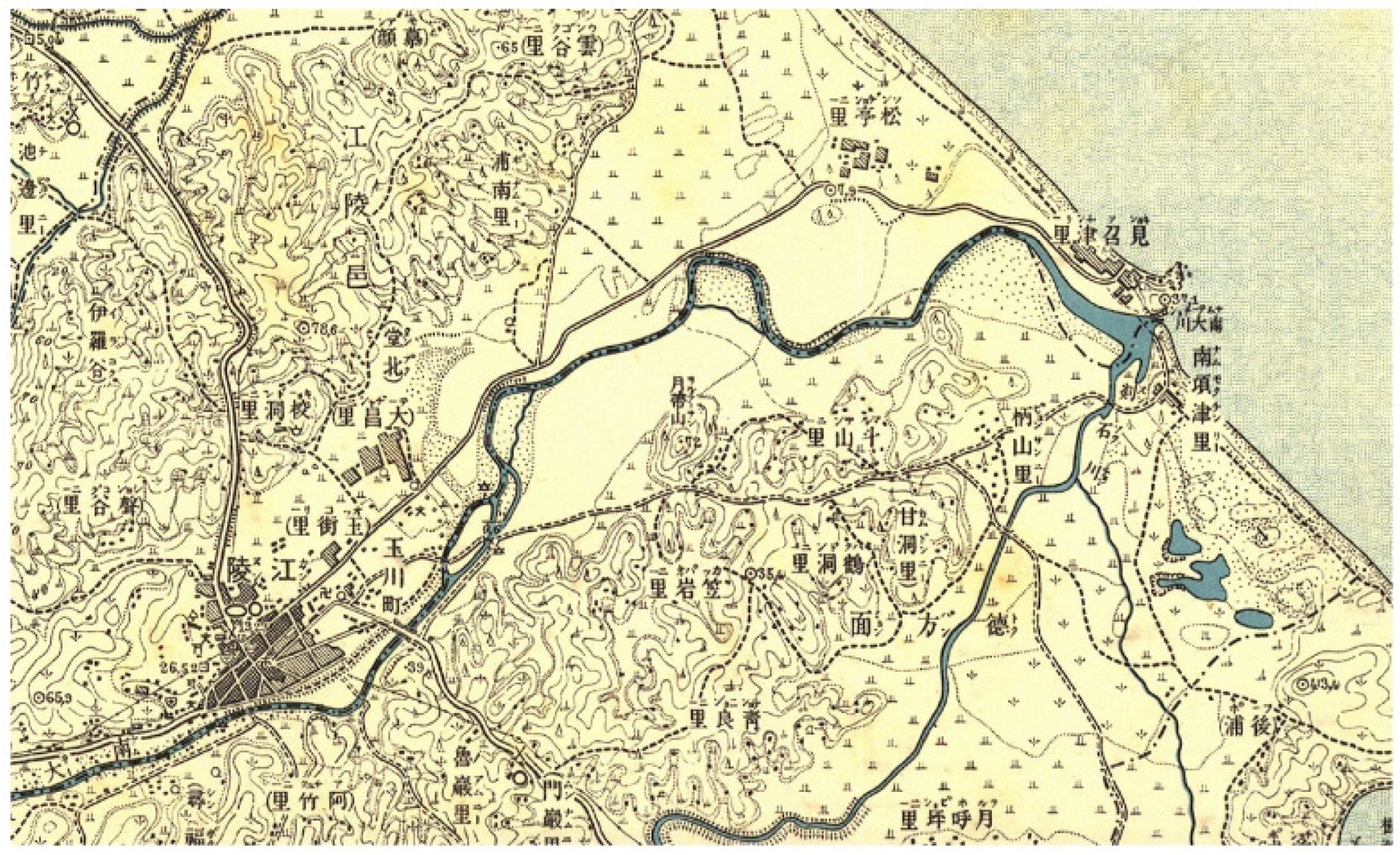
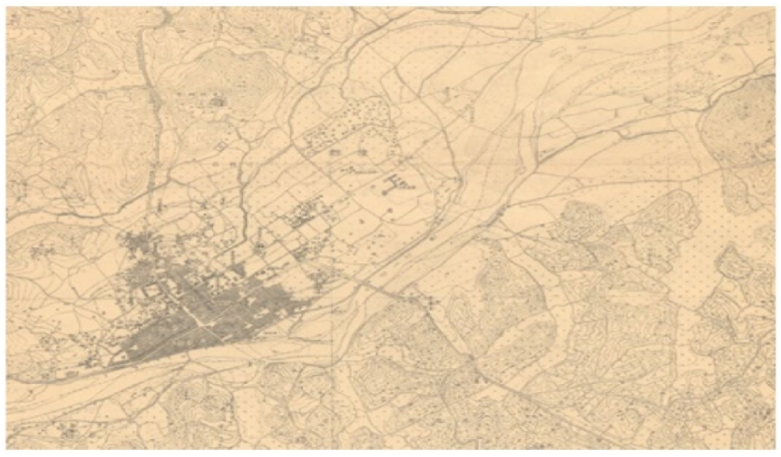
| 1915 | 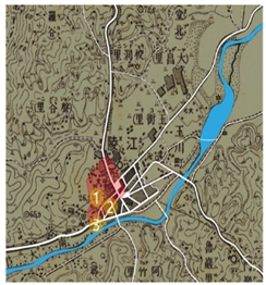 | Gangneung Ordinary School (currently Gangneung Elementary School) established in 1896 Gangneung Post Office opened in 1898 Jahye Clinic, the predecessor of Gangneung Medical Center, established in 1913 |
| 1933 | 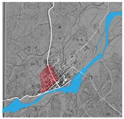 | Characteristics of the original downtown area in 1933 Started supplying electricity to Gangneung-eup in 1929 Gangneung-myeon was promoted to Gangneung-eup in 1931 Formation of new roads in the original city center |
| Division | Main Photo 1 | Main Photo 2 |
|---|---|---|
| Gyeongpo Lake | 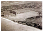 | 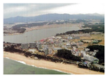 |
| Main roads | 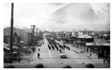 | 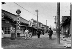 |
| Period | Floor Plan Analysis | Characteristics |
|---|---|---|
| 1966 | 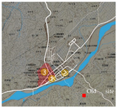 | First market (Gotgam Alley, Geumbang Alley area) established in Seongnam-dong, Gangneung City in 1943. Second market (Jungang Market) opened in Seongnam-dong, Gangneung City in 1954. Third market (Seobu Market) opened in Yonggang-dong, Gangneung City in 1956. |
| 1973 | 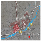 | Loss of Jaegeon Bridge (Namsan Bridge) in 1970. Completion of Gangneung Bridge expansion in 1971. Embankment construction between Gangneung Bridge and Seongdeok Elementary School in 1972. |
| 1989 | 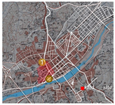 | Work on the west market began in 1981. Formation of Nammun-dong Furniture Alley. Yeongdong-Donghae Expressway opened in 1988. |
| Category | Main Photo 1 | Main Photo 2 |
|---|---|---|
| Gangneung City’s original downtown in development | 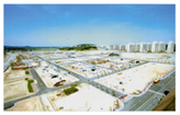 | 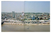 |
| Main roads | 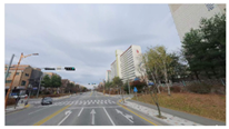 | 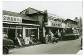 |
| Period | Floor Plan Analysis | Characteristics |
|---|---|---|
| 1996 | 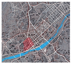 | Songjeong District Housing Site Development Project in 1991 Integrated Gangneung City launched in 1995 Extension of Naegok Bridge completed in 1993 Completion of Gangneung Terminal (Hongje-dong) in 1995 |
| 2005 | 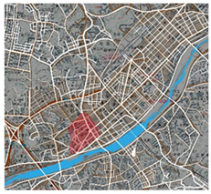 | Opening of Gangneung Indoor Ice-Skating Stadium in 1998 Gangneung City’s new building in 2001 Completion of Solol district (Gyodong housing site) construction project in 2000 Yeongdong Expressway 4-lane extension in 2001 |
| Category | Analysis | ||
|---|---|---|---|
| Floor plans for analysis | 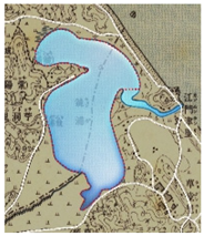 | 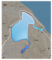 | 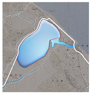 |
| Characteristic (1) | 1915 Area: ~1.74 km2 Circumference: ~7.70 km | 1966 area: ~1.17 km2 Circumference: ~6.86 km | 1973 Area: ~1.00 km2 Circumference: ~4.28 km |
| Characteristic (2) | The surrounding area is used as agricultural land to secure agricultural crops. | Gyeongpo Beach Donghae Bukbu railway line opened in 1962 Gyeongpodae purification project in 1966 Gyeongpo Lake shoreline construction started in 1966 | Gyeongpo Road construction in 1967 Gyeongpo Lake dredging work started in 1969 Gyeongpo Beach and Gyeongpo Lake designated as tourist destinations in 1969 Gyeongpo Beach Jungang Tong Shopping Mall completed in 1970 Gangneung Beach Hotel (currently Hotel Hyundai) completed in 1971 |
| Floor plans for analysis | 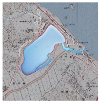 |  | 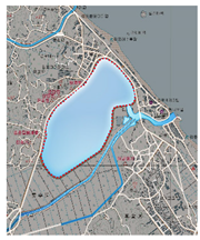 |
| Characteristic (1) | 1989 Area: about 0.93 km² 989 Area: about 0.93 km 4.21 km | 1996 Area: about 0.93 km2 Circumference: about 4.20 km | 2005 Area: about 1.00 km2 Circumference: about 4.29 km |
| Characteristic (2) | Demolition of Jungangtong Shopping Street at Gyeongpo Beach in 1980 Designated as Gyeongpo Provincial Park via Gangwon-do Public Notice No. 89 in 1982 Inundation damage at Gyeongpo Jinan Shopping Center due to the great flood in 1984 | Gyeongpo Lake Dredging Project in 1991 Purification project, including the effluent channel improvement project, in 1991 | Gyeongpo Beach New Millennium Sunrise Festival in 2000 Unification Park opened in 2001 |
| Category | Floor Plan Analysis | Characteristics | Category | Floor Plan Analysis | Characteristics | Legend |
|---|---|---|---|---|---|---|
| Original downtown area |  | Physical environment survey focusing on an area of ~357,000 m2 in Gangneung City’s original downtown area Residential environment that includes multi-generational, and multi-family households and market district centered around the central market Many traditional houses from the Japanese colonial period. Some buildings have been remodeled and are being used as cafés. | Gyeongpo Lake area | 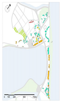 | Changes in surrounding areas related to changes in the shape of Gyeongpo Lake Form and location of the building considering Gyeongpo Beach on the right and Gyeongpo Lake on the left Investigation of some residential buildings and commercial and leisure facilities as the main building use | 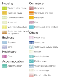 |
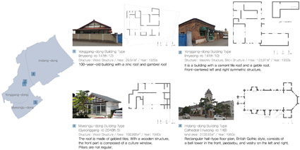
| Characteristics of the Main Buildings |
|---|
 |
 |
| Division | Urban Space Locations | Analysis | Features | ||||||||
|---|---|---|---|---|---|---|---|---|---|---|---|
 | Division | Building | Floor area | ||||||||
|
| Primary stages:1910–1954 | Year | B (EA) | Ratio (%) | Total (m2) | Mean (m2) | Year | B (EA) | Ratio (%) | Total (m2) | Mean (m2) | |
| 1910s | 33 | 3.4 | 2762.3 | 83.7 | Industrial facilities | 14 | 1.4 | 4364.2 | 311.7 | Analysis of residential and business facilities as a leading architectural type. Actual construction types were limitedly investigated. One-story architecture is the centerpiece. | |
| 1920s | 113 | 11.6 | 7960.8 | 70.5 | Cultural gathering facilities | 5 | 0.5 | 739.5 | 147.9 | ||
| 1930s | 251 | 25.8 | 19,830.4 | 79 | Business facilities | 4 | 0.4 | 697.4 | 174.4 | ||
| 1940s | 411 | 42.2 | 33,416.5 | 81.3 | Education and welfare facilities | 1 | 0.1 | 78.9 | 78.9 | ||
| –1954 | 166 | 17 | 9618 | 57.9 | Neighborhood living facilities | 136 | 14 | 14,532.4 | 106.9 | ||
| total | 974 | 100 | 73,588.0 | 74.5 | Residential business facilities | 814 | 83.6 | 53,175.5 | 65.3 | ||
| Total | 974 | 100 | 73,588.0 | 147.5 | |||||||
| Division Year | Building | Floor area | Wooden architecture is the focus, and some masonry and steel-framed constructions have been investigated. | ||||||||
| B (EA) | Ratio (%) | Total (m2) | Mean (m2) | ||||||||
| 1F | 924 | 94.9 | 64,301.5 | 69.6 | |||||||
| 2F | 46 | 4.7 | 7526.9 | 163.6 | |||||||
| 3F | 4 | 0.4 | 1759.5 | 439.9 | |||||||
| Total | 974 | 100 | 73,588.0 | 224.4 | |||||||
| Division year | Building | Floor area | Single-story housing type is related to the dominant characteristic. | ||||||||
| B (EA) | Ratio (%) | Total (m2) | Mean (m2) | ||||||||
| Masonry | 90 | 9.2 | 8772.8 | 97.5 | |||||||
| Concrete | 6 | 0.6 | 2090.8 | 348.5 | |||||||
| Steel frame | 23 | 2.4 | 6322.6 | 274.9 | |||||||
| Woodcarving | 854 | 87.7 | 56,343.5 | 66 | |||||||
| Other | 1 | 0.1 | 58.4 | 58.4 | |||||||
| Total | 974 | 100 | 73,588.0 | 169 | |||||||
 | Division | Building | Floor area | ||||||||
|
| Secondary stages:1957–1981 | Year | B (EA) | Ratio (%) | Total (m2) | Mean (m2) | Year | B (EA) | Ratio (%) | Total (m2) | Mean (m2) | |
| –1959 | 261 | 2.4 | 20,197.1 | 77.4 | Automobile related facilities | 69 | 0.6 | 73,911.7 | 1071.2 | Residential business type architecture was the center, and the type of neighborhood living facility gradually increased. | |
| 1960s | 432 | 4.1 | 38,046.7 | 88.1 | Industrial facilities | 204 | 1.9 | 443,314.4 | 2173.1 | ||
| 1970s | 2793 | 26.2 | 441 361.9 | 158 | Telecommunication facilities | 10 | 0.1 | 16,229.5 | 1623 | ||
| 1980s | 4787 | 44.9 | 2,306,966.5 | 481.9 | Cultural gathering facilities | 69 | 0.6 | 85,997.4 | 1246.3 | ||
| –1994 | 2393 | 22.4 | 2,577,412.0 | 1077.1 | Business facilities | 202 | 1.9 | 221,486.3 | 1096.5 | ||
| Total | 10,666 | 100 | 5,383,984.2 | 376.5 | Education and welfare facilities | 236 | 2.2 | 1,613,461.0 | 6836.7 | ||
| Neighborhood living facilities | 1889 | 17.7 | 788,017.4 | 417.2 | |||||||
| Residential business facilities | 7962 | 74.6 | 2,138,219.8 | 268.6 | |||||||
| Other facilities | 25 | 0.2 | 3346.8 | 133.9 | |||||||
| Total | 10,666 | 100 | 5,383,984.2 | 1651.8 | |||||||
| Division | Building | Floor area | |||||||||
| Year | B (EA) | Ratio (%) | Total (m2) | Mean (m2) | |||||||
| 1F | 4615 | 43.3 | 417,317.3 | 90.4 | Residential types of the first and second floors were mainly observed. | ||||||
| 2F | 3888 | 36.5 | 830,558.5 | 213.6 | |||||||
| 3F | 1108 | 10.4 | 732,841.4 | 661.4 | |||||||
| 4F | 606 | 5.7 | 1,781,554.9 | 2939.9 | |||||||
| More than 5F | 449 | 4.2 | 1,621,712.2 | 3611.8 | |||||||
| Total | 10,666 | 100 | 5,383,984.2 | 1503.4 | |||||||
| Division | Building | Floor area | |||||||||
| Year | B (EA) | Ratio (%) | Mean (m2) | ||||||||
| Masonry | 6190 | 58 | 791,585.7 | 127.9 | The architecture of masonry and the concrete structure were analyzed as the central structural form. This is related to the residential and work-oriented tangible characteristics. | ||||||
| Concrete | 2546 | 23.9 | 4,006,839.4 | 1573.8 | |||||||
| Steel frame | 571 | 5.4 | 485,954.6 | 851.1 | |||||||
| Reinforced Concrete | 9 | 0.1 | 18,326.4 | 2036.3 | |||||||
| Woodcarving | 1349 | 12.6 | 81,183.0 | 60.2 | |||||||
| Other | 1 | 0 | 95 | 95 | |||||||
| Total | 10,666 | 100 | 5,383,984.2 | 790.7 | |||||||
| Division | Urban Space Locations | Analysis | Features | ||||||||
|---|---|---|---|---|---|---|---|---|---|---|---|
 | Division | Building | Floor area | ||||||||
|
| Tertiary stages: 1995–now | Year | B (EA) | Ratio (%) | Total (m2) | Mean (m2) | Year | B (EA) | Ratio (%) | Total (m2) | Mean (m2) | |
| –1999 | 1841 | 29 | 2,644,696 | 1436.6 | Automobile related facilities | 93 | 1.5 | 98,452.0 | 1058.6 | The number of building types for residential work increased continuously, and the number of diversified building types such as neighborhood living facilities, industrial facilities, and education and welfare facilities increased. | |
| 2000s | 2675 | 42.2 | 3,245,999 | 1213.5 | Industrial facilities | 298 | 4.7 | 95,780.2 | 321.4 | ||
| 2010s | 1776 | 28 | 753,662.9 | 424.4 | Telecommunication facilities | 6 | 0.1 | 13,634.1 | 2272.4 | ||
| 2020 | 48 | 0.8 | 51,325.1 | 1069.3 | Cultural gathering facilities | 85 | 1.3 | 110,005.7 | 1294.2 | ||
| Total | 6340 | 100 | 6,695,682.8 | 1035.9 | Business facilities | 170 | 2.7 | 1,310,196.6 | 7707 | ||
| Education and welfare facilities | 268 | 4.2 | 726,036.5 | 2709.1 | |||||||
| Neighborhood living facilities | 1899 | 30 | 905,173.1 | 476.7 | |||||||
| Residential business facilities | 3498 | 55.2 | 3,431,201.6 | 980.9 | |||||||
| Other facilities | 23 | 0.4 | 5203 | 226.2 | |||||||
| Total | 6340 | 100 | 6,695,682.8 | 1894.1 | |||||||
| Division | Building | Floor area | |||||||||
| Year | B (EA) | Ratio (%) | Total (m2) | Mean (m2) | |||||||
| 1F | 1780 | 28.1 | 262,946.5 | 147.7 | The scale of buildings with one to three stories increased evenly, and buildings with four and five stories showed an increasing trend. | ||||||
| 2F | 1528 | 24.1 | 481,927.7 | 315.4 | |||||||
| 3F | 1684 | 26.6 | 870,387.3 | 516.9 | |||||||
| 4F | 660 | 10.4 | 636,200.9 | 963.9 | |||||||
| Greater than 5F | 688 | 10.9 | 4,444,220.4 | 6459.6 | |||||||
| Total | 6340 | 100 | 6,695,682.8 | 1680.7 | |||||||
| Division | Building | Floor area | |||||||||
| Year | B (EA) | Ratio (%) | Total (m2) | Mean (m2) | As the diversification of types and the number of stories increased, the number of concrete and steel frame structures also increased, including some masonry and wooden structures. | ||||||
| Masonry | 450 | 7.1 | 64 943.6 | 144.3 | |||||||
| Concrete | 3770 | 59.5 | 4 853 973.6 | 1287.5 | |||||||
| Steel frame | 1839 | 29 | 584 619.3 | 317.9 | |||||||
| Reinforced Concrete | 47 | 0.7 | 1 161 032.3 | 24 702.8 | |||||||
| Woodcarving | 225 | 3.5 | 30 581.9 | 135.9 | |||||||
| Other | 9 | 0.1 | 532.1 | 59.1 | |||||||
| Total | 6340 | 100 | 6 695 682.8 | 4441.3 | |||||||
Publisher’s Note: MDPI stays neutral with regard to jurisdictional claims in published maps and institutional affiliations. |
© 2022 by the author. Licensee MDPI, Basel, Switzerland. This article is an open access article distributed under the terms and conditions of the Creative Commons Attribution (CC BY) license (https://creativecommons.org/licenses/by/4.0/).
Share and Cite
Park, H. Changes in Contemporary Form in Gangneung City through Cadastral Data Analysis and Application of the Spatial Politics Concept. Sustainability 2022, 14, 9418. https://doi.org/10.3390/su14159418
Park H. Changes in Contemporary Form in Gangneung City through Cadastral Data Analysis and Application of the Spatial Politics Concept. Sustainability. 2022; 14(15):9418. https://doi.org/10.3390/su14159418
Chicago/Turabian StylePark, Hoon. 2022. "Changes in Contemporary Form in Gangneung City through Cadastral Data Analysis and Application of the Spatial Politics Concept" Sustainability 14, no. 15: 9418. https://doi.org/10.3390/su14159418
APA StylePark, H. (2022). Changes in Contemporary Form in Gangneung City through Cadastral Data Analysis and Application of the Spatial Politics Concept. Sustainability, 14(15), 9418. https://doi.org/10.3390/su14159418