Article

Long-Term Landscape Dynamics to Assess Land Degradation Hypotheses—An Exploratory Study of Evidence from Travelers’ Narrations

1
Department of Economics and Sustainable Development, Harokopio University, Venizelou 70, 176 76 Athens, Greece
2
Institute of Historical Research, National Hellenic Research Foundation, 48 Vassileos Constantinou Ave., 116 35 Athens, Greece
*
Author to whom correspondence should be addressed.
Sustainability 2022, 14(14), 8543; https://doi.org/10.3390/su14148543
Submission received: 31 May 2022 / Revised: 5 July 2022 / Accepted: 6 July 2022 / Published: 12 July 2022

Abstract

:
The present study aims to provide a method for extending the scope of empirical landscape studies into the more distant past and to use it to contribute to the discourse on land degradation in the Mediterranean area. In many areas of the world, the lack of spatially explicit sources, such as historical land cover maps and cadasters, is an obstacle to extending the study of landscape dynamics in the past. Information mined from travelers’ texts can be used to overcome it. Landscape descriptions retrieved from W.M. Leake’s narration of his travels in Peloponnese, Greece, in 1805 and 1806, were georeferenced and used to test for the occurrence of land degradation by comparing historical to current landscapes. A widespread transition of natural vegetation to agricultural areas was found mostly in low altitudes. Limited rewilding occurred on steeper slopes. About a third of the historical Greek fir forests were degraded to open stands. A total of 40% of the locations covered by deciduous oak forests were converted to agricultural areas; most of the rest of these locations were converted to vegetation types characteristic of lower precipitation and soil fertility. Long-term dynamics can be efficiently assessed using narrations as a source of information. The comparison of early 19th century descriptions with the current condition suggests that limited land degradation did take place in the previous centuries in the study area.

1. Introduction

A long-standing debate revolves around the issue of land degradation in the Mediterranean area; especially concerning the north part of it, the consensus of the occurrence of widespread degradation processes throughout historical times [1] has been repeatedly challenged. Recent views vary; some limit the era of degradation to modern times [2] or challenge the degradation consensus altogether by pointing to contradictory processes [3,4]. Several issues hinder the settling of the ongoing debate, including the usually short time frames considered in the empirical studies. The present study aims to provide a method for extending the scope of empirical studies into the more distant past by tapping historical landscape descriptions and to apply it, so as to assess its usefulness.
Empirical cartography-based studies on landscape dynamics are largely limited to the era of aerial photography and sometimes to the even more limited era of satellite imagery, a quite short-term time frame [5]. Approaches based on palynology or dendrochronology produce valuable insights but have limited ability to reconstruct a spatially explicit representation of past landscapes [6]. Historical documents, on the other hand, represent an underutilized source of information for studying long-term landscape dynamics, partly due to the lack of communication between natural sciences and humanities.
Reconstructions of past landscapes from explicitly spatial historical sources, such as historical land cover maps, cadasters or even charcoal data, have started appearing in the literature [7,8,9]. However, spatially explicit material is not universally available. An alternative is to georeference information, such as descriptions extracted from travelers’ books, notes or diaries. Using narrations for retrieving environmental information has been applied to investigate climate patterns [10] and, rarely, at a higher spatial resolution, to establish past species distribution [11]. Travelers’ narrations are widely available for southeast Europe and eastern Mediterranean, especially since the late 17th century, and they have been used in various studies focusing either on the inhabitants or on the travelers. Previous efforts using narrations as data sources in a similar environment resulted in a very broad classification of landscapes and coarse spatial scales [12,13] or focused on limited areas and facets of the landscape [14]. To the best of our knowledge, no attempt of a spatially explicit reconstruction of past landscapes by means of accurate mapping and detailed land cover classification based on such narrations has been published up to now. The present study aims to contribute to this direction.
According to the Intergovernmental Science-Policy Platform on Biodiversity and Ecosystem Services (Intergovernmental Science-Policy Platform on Biodiversity and Ecosystem Services, IPBES, 2018) ‘Land degradation refers to the many processes that drive the decline or loss in biodiversity, ecosystem functions or services, and includes the degradation of all terrestrial ecosystems including associated aquatic ecosystems that are impacted by land degradation’. Specific criteria were devised in the present study by drawing on this understanding using landscape change as a proxy variable to assess them. Selected transitions between landscape configurations, each capturing a different facet of the definition, were adopted as criteria to test its occurrence during the past two centuries. The proposed approach is applied in W.M. Leake’s three-volume and approximately 1500-pages-long work ‘Travels in the Morea’ [15], narrating his journeys in Peloponnese, southern Greece, in 1805 and 1806.

2. Materials and Methods

2.1. Leake’s Routes and Landscape

Leake visited Peloponnese (Scheme 1) in the final years of the Ottoman rule in the area, shortly before the 1821 revolution and the founding of the Greek state in 1828. The rural landscape descriptions available in the books were extracted by reading the text throughout and modeled in a spatial database by georeferencing them. An automated georeferencing procedure was ruled out due to the less-than-perfect outcome of the optical character recognition procedures available and, most importantly, the heterogeneity of the landscape descriptions that precluded the compilation of a realistic list of keywords to be sought.
Establishing the traveled routes proved to be indispensable for georeferencing the landscape descriptions. In the first step of this task, locations mentioned in the text that were related to the route were georeferenced (called nodes hereafter). Three major kinds of difficulties had to be overcome: (a). a large number of settlements were renamed in the meantime; (b). a number of landmarks do not exist anymore (e.g., chans—inns, dervenia—guarded passes, some bridges); (c). a number of landmarks, even if still present, are not depicted in modern maps, since they have lost their significance (e.g., kefalovrysa—major freshwater springs). These problems were tackled by using a digitized version of the map produced by the French Scientific Expedition, based on surveys carried out from 1829 onward in the study area [16] (a topographical map without any information about land cover). Additionally, a database of historical settlement names was sometimes consulted (https://settlement-renames.eie.gr/ (last accessed on 10 January 2022)), and, in very few cases, landmarks not captured on the historical map could be found on modern maps (castle and monastery ruins mostly). The nodes were then connected to establish the traveled routes by taking into account historical roads depicted in the 19th century map and geomorphology, in the sense of the most probable route to take and of relevant descriptions found in the text. The area of Mani (Supplementary Material, Map S2) was excluded, since the route was already made available by Ref. [17].
Georeferencing the landscapes described in the text was carried out in two ways, depending on the nature of the description. The first, straightforward way was direct mapping when the description of the location was made relative to a landmark that could be found on a map, e.g., above or around a village. When a reference was made to something viewed from a distance, e.g., high altitudes of a mountain, it was necessary to establish the angle from which Leake viewed it, based on the knowledge of his route. Additionally, especially in remote areas, the location was defined relative to the traveled route, e.g., landscapes through which he walked or rode after a certain travel time. These locations were georeferenced by taking into account the route and making assumptions about the pace of travel based on historical knowledge, terrain characteristics and an estimation of mean travel pace per route, based on Leake’s meticulous reporting of time.

2.2. Background Data

The following data sources were used to establish the environmental background of the studied landscapes:
(1)
A digital elevation model of spatial resolution 25 m (European Digital Elevation Model EU-DEM, version 1.1) was retrieved from the Copernicus database. The slope was calculated based on the above DEM. The 40-year median of mean annual temperature and the median of annual precipitation at 1 km-to-1 km spatial resolution were retrieved from the Copernicus Climate Data Store. Each point associated with a landscape description was assigned a value of these four variables.
(2)
Current land cover data for the whole of the area were drawn from the Corine Land Cover program (henceforth CLC). The version 2020_20u1 for the year 2018 that was taken into account provides data of scale 1:100,000, 25 ha minimum mapping unit and 100 m minimum width for linear elements. Additionally, the habitat mapping carried out by the project ‘Development of large scale (1:5000) spatial data infrastructure for terrestrial areas protected under the Νatura 2000 network at a national scale’ was taken into account (Supplementary Material, Map S1). The vector files were obtained from the Greek Ministry of Environment and Energy.

2.3. Landscape Dynamics

The georeferenced landscape descriptions were compared with the current state, as depicted in the CLC 2018 database, based on the compatibility of Leake’s description with the CLC class criteria. Since the CLC nomenclature is organized on three hierarchical levels, each point was judged up to the level that Leake’s description allowed. In the case of habitat classification data that were only available for Natura 2000 areas, this exercise considered a relatively small number of points, which did not allow a quantitative analysis. These data were interpreted qualitatively to aid the analysis of CLC data.
The terms ‘natural area’ and ‘natural vegetation’ in the present work refer to plant communities that grow without human cultivation and do not imply areas not affected by human activities.

2.4. Analysis

Degradation criteria were operationalized and quantified by assessing the balance of the following processes and their opposites:
  • Transition of natural vegetation toward human dominated landscapes: Number of points that changed from natural vegetation to CLC classes 1 (‘Artificial areas’) and 2 (‘Agricultural areas’).
  • Transition of agricultural land or dense natural vegetation toward sparsely vegetated landscapes: Number of points switching from agricultural use or other natural vegetation cover types to CLC class 3.3 (‘Open spaces with little or no vegetation’).
  • Transition of natural vegetation dominated landscapes toward types characteristic of lower soil fertility and/or higher drought stress: The dynamics of two types of vegetation considered as prone to degradation in the Mediterranean were investigated: supra- and low-montane-Mediterranean Greek fir (Abies cephalonica) forests and meso- and supra-Mediterranean deciduous oak (Quercus sp.) forests. These forests were explicitly referred to by Leake and indirectly derived from CLC, since they comprise the vast majority of CLC class 312 (‘Coniferous forests’), in altitudes greater than 900 m asl in the first case, and of class 311 (‘Broad-leaved forests’) in lower elevations in the second.
The environmental frame of the first criterion was set by a logistic regression model, which was fitted using change versus no change as the dependent variable and environmental variables as explanatory ones. Only agricultural landscapes and those dominated by natural vegetation (corresponding to CLC classes 2 and 3) were used in this analysis due to the low number of landscapes classified in any of the remaining CLC classes. Assumption testing was carried out by visually inspecting the binned residual plots. The residuals were tested for non-random geographic pattern, applying the spatial autocorrelation method based on Global Moran’s I, and no spatial autocorrelation was detected. Differences in the environmental settings between location groups were assessed by the Wilcoxon signed rank test.
Mapping operations and spatial analysis of residuals were carried out by ArcGIS v. 10.8.1. Statistical analyses were carried out in R environment [18]. The following packages were used: ‘ResourceSelection’ [19] for the Hosmer–Lemeshow goodness of fit test, ‘pROC’ and ‘plot ROC’ [20,21] for plotting the receiver operating characteristic (ROC) curves for the logistic regression models, ‘arm’ [22] for the binned residual plots and ‘hier.part’ [23] for hierarchical partitioning.

3. Results

3.1. Mapping and Environmental Background

The nodes referred to in Leake’s text, as well as the derived routes traveled, are presented in Scheme 2 (left). The locations for which a landscape description was available are presented in Scheme 2 (right). Out of 482 landscapes mapped in total, 464 were retained for analysis, and 18 were dropped. The latter either could not be located with the necessary certainty, or the description referred to plane stands along river banks without description of the surroundings. As these plane stands are usually not wide enough to be depicted in CLC maps, these locations were not considered further.
Table 1 depicts the relationships among background environmental variables of the studied locations. Temperature and elevation are almost perfectly correlated. Precipitation does not follow the same pattern due to the rain-shadow effect that creates an east–west gradient of increasing precipitation. Slope also increases with altitude; however, steep slopes also occur in low altitudes, as level areas do in higher ones.

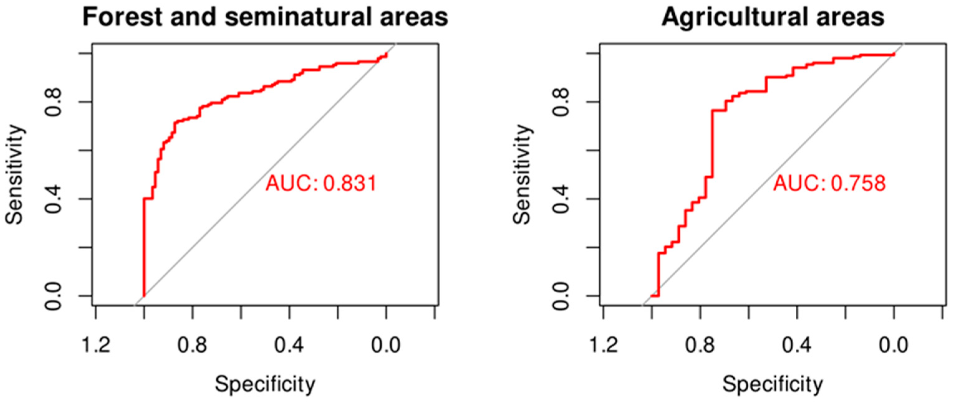
3.2. Balance of Natural Vegetation Dominated Landscapes

The transitions between different broad land cover classes are presented in Table 2 (also Supplementary Material, Maps S2 and S3). According to the data available from the Greek statistics authority, the cultivated area in the Peloponnese accounted for 459,158.5 ha in 1911 (earliest available figure) and 551,307.9 in 1961—at the verge between the eras of traditional and intensive agriculture in Greece—and 382,591.3 ha in 1999. These figures are not strictly comparable, since old surveys are known to suffer from inaccuracies, and the methods changed with time, but the trends are clear. These trends mirror the population trends. Indicatively, the population of the Peloponnese was estimated at around 500,000 inhabitants prior to the 1821 revolution by the first Greek government and at 384,322 around 1832, the reduction being due to casualties and displacements. It rose to 907,103 in the survey of 1907 and 1,070,756 in 1961, on the verge of the rural exodus era. The population rise since then concerned mostly urban centers.
Quantitative analysis of the ‘Balance of natural vegetation dominated landscapes’ criterion is limited to locations that in the 19th century fell within CLC classes 2 ‘Agricultural areas’ and 3 ‘Forest and semi-natural areas’, which provide a sufficient number of points. ‘Forest and semi-natural areas’ accounted for 51% of all mapped locations, ‘Water bodies’ and ‘Wetlands’ for 3.7% each, while ‘Agricultural areas’ accounted for 42% in the early 19th century. The current values are 37%, 1.3%, 2% and 56%, respectively. The environmental variable values of each case of persistence or transition are summarized in Table 3 and Table 4.
Limiting the cells of Table 2 to the 2 × 2 table of agricultural cover and natural vegetation, a significant dependence is found with natural vegetation more prone to turn to agricultural than vice versa (Pearson χ2, p < 0.001) (Supplementary Material, Maps S2 and S3). The two opposite processes were driven by different environmental variables; therefore, two different logistic regression models were fitted to link the odds of change with the underlying environmental variables (Table 5, Figure 1). Transition of formerly agricultural areas into natural vegetation was limited in extent and largely driven by slope; areas that ceased to be cultivated lie on steeper ground than areas that did not (Table 3 and Table 5, Figure 1). Areas covered by natural vegetation were more prone to agricultural conversion in lower altitudes and wetter areas (Table 4 and Table 5, Figure 1). Hierarchical partitioning attributed 96% of the variance explained by the logistic regression model to elevation and only 4% to precipitation. As a result, the median altitude of locations under natural vegetation shifted from 484 m to 738 m asl.
The reduction in landscapes characterized by natural vegetation is larger than suggested by the number of transitions because the plains that are now fully cultivated were reported as underutilized and, to various degrees, devoted to grazing. ‘When I asked one of the cottagers why he did not sow more corn (i.e., winter cereals) in such a fertile soil,—“Where are we to get seed?” was the answer’ (Vol. II p.28). These locations were mapped as agricultural areas, since this was the dominant use according to Leake’s descriptions. However it is also apparent that significant patches of natural vegetation were interspersed among the fields. This was also a matter of institutional setting, which was quite fragmented at the time. For example, ‘The district of Nisi (modern name: Messene), which occupies the lowest part of the plain, is not less rich and well cultivated than that of Kalamata; but the opposite side and adjacent hills belonging to Andrussa, are in a very different state; …’ and further ‘Kalamata and Nisi are favoured districts, on account of the greater part of them being crown lands.’ (Vol. I p. 358). The Mani peninsula (Supplementary Material, Map S2), which stood out for its semi-autonomous regime within the Ottoman empire, is, due to high population levels, the only area cultivated to its limits, ‘… their chief evil is a population disproportioned to the natural resources of the country.’ (Vol. I, p. 309). The institutional setting became much more homogeneous after the founding of the Greek state.
The low number of locations of ’Wetlands’ and ‘Water bodies’ did not allow a quantitative analysis. Many of these were converted to agricultural land, and only one was turned from agricultural to ‘Water bodies’ due to the construction of a dam and artificial lake. Some ‘Water bodies’ turned to ‘Wetlands’, suggesting a reduction in the available amount of water.

3.3. Balance of Sparsely Vegetated Areas

3.3.1. Transition to Sparse Vegetation Cover

Only three locations were found belonging to CLC class 333 ‘Sparsely vegetated areas’, one of which was reported as ‘bare of trees’ by Leake, the second as ‘sprinkled with oaks’ and the third as cultivated terraces. The latter case, located in Mani (the distinct status of which was already mentioned), is the only one that satisfies this criterion of degradation.

3.3.2. Transition from Sparse Vegetation Cover

Twenty-four locations described as ‘bare’ or ‘barren’ by Leake were sorted out to examine their fate. Bare or barren in the eyes of a 19th century Briton does not necessarily mean sparsely vegetated in today’s classification, indicatively: ‘a barren, uncultivated coast, covered with shrubs’, also ‘a barren tract, rocky and covered with bushes of mastic (i.e., Pistacia lentiscus), holly-oak (unlike the modern common name, Leake referred to Quercus coccifera), and wild olive (i.e., Olea europea)’. In this sense, the domination of Mediterranean shrubs in Leake’s time cannot be ruled out, even when it is not explicitly stated as in the above quotes. Therefore, transitions to CLC classes 321 ‘Natural grassland’ (3 cases) and 323 ‘Sclerophyllous vegetation’ (10 cases) cannot be safely considered as real ones. Transitions to 312 ‘Coniferous forests’ (3 cases) can be considered real transitions and, along with the transitions to ‘Agricultural areas’ (7 cases), suggest that the productive potential was available. A single location is currently classified as 333 ‘Sparsely vegetated areas’, which is consistent with ‘bare’ or ‘barren’ in the strict sense.

3.4. Balance of Forest Dominated Landscapes

3.4.1. Supra- and Low-Montane-Mediterranean Conifers

Reference to firs was made by Leake in 46 locations; 11 concerned scattered trees or presence in association with cultivated fields; the rest were fir forests, around 70% of which are currently classified as CLC class 312 ‘Coniferous forests’ (Table 6 and Supplementary Material, Map S4).
Six of these locations are included in the Natura 2000 habitat mapping. Three of them were classified as Greek fir forest, two as black pine (Pinus nigra) forest and one as east Mediterranean garrigue. No reference was made by Leake to black pine, which currently forms forests in the same zone (Supplementary Material, Map S5). The rest of the former Greek fir forests switched to classes characteristic of lower precipitation and/or soil fertility (Table 6 and Supplementary Material, Map S4). The difference in the environmental variables was not statistically significant (Wilcoxon test) between the changed and the persisting group.
Two sites seem to be recent gains of the CLC class ‘Coniferous forest’. These were described by Leake as ‘bare rocky summit’ and ‘barren ridge’. Both sites are included in the Natura 2000 habitat mapping: one as east Mediterranean garigue and one as Greek fir forest. The differences between the two classifications may be due either to erroneous classification by one of them or a result of the very different scales of mapping.

3.4.2. Meso- and Supra-Mediterranean Deciduous Oak Forests

A total of 59 landscape descriptions including the term ‘oak’ were found; 19 of them referred to evergreen species, low density of tree cover or individuals embedded in agricultural landscapes (more references to evergreen Quercus species were found that did not include the term ‘oak’).
Only three of these locations are currently classified as CLC class 311 ‘Broad-leaved forest’ (Table 7 and Supplementary Material, Map S6). Two of them are found in the Natura 2000 habitat mapping as ‘Mediterranean oak forests (dominated by Q. cerris and Q. petrae)’. The very low number of locations where deciduous oaks forests persist rendered a formal statistical testing of differences in environmental variables meaningless.
A total of 40% of the historical deciduous oak forest locations were converted to farmland. However, around 17% of them were classified as 243 ‘Land principally occupied by agriculture, with significant areas of natural vegetation’, pointing to a conversion process that retained patches of natural vegetation. The remaining locations under natural vegetation largely changed into more stress-tolerant vegetation types, with a possible exception of a single location in 744 m asl classified as coniferous forest that could be black pine.
Out of the 12 locations currently classified as 311 ‘Broad-leaved forest’, 7 were reported by Leake as wooded with oaks (the 3 persisting cases), chestnut (2 cases), or planes (1 case), or just wooded without reference to species (1 case). One was described as pine forest (in the Natura 2000 habitat mapping, it is classified as plane forest, consistent with CLC class 311) and four as cultivated. Three out of the latter four cultivated sites were included in the Natura 2000 habitat mapping. Two of them are classified as chestnut woods (probably under cultivation) and one as east Mediterranean garigue (see ‘Balance of forest dominated landscapes’ on this discrepancy). Therefore, the loss of deciduous oak forests was not balanced by the opposite process.

4. Discussion

In the present study, the use of non-spatially-explicit data sources, namely descriptions extracted from travelers’ narrations, was explored in order to study landscape dynamics. It was hypothesized that this kind of source can be effectively used to retrieve information suitable as a proxy for addressing the issue of long-term degradation in the northern Mediterranean.
The initial idea of applying an automated georeferencing procedure was given up after being confronted with the text. References to locations in the text were often made relevant to a landmark, so that human interpretation was needed to pinpoint the exact position [24]. Additionally, the transcription of Greek names in the available gazetteer, based on the digitized map of the French Scientific Expedition [16], was different from the transcription adopted by Leake. The similarities of names referring to the same location apparent to a human interpreter would be missed by an automated procedure.
The major insight gained in the process of georeferencing the landscape descriptions was that, while some could be georeferenced right away, many others required establishing the route of the traveler, especially in remote areas. This task is greatly facilitated by the existence of relevant contemporary cartographic material, gazetteers or databases referring to the same era [25]. Otherwise, the effort needed to pinpoint each location may become prohibitive.
With respect to natural habitat loss, the analysis of Leake’s landscape descriptions showed a widespread transformation of natural vegetation to agricultural areas over the past 200 years, which took place more intensively in lower elevations and the wetter parts of Peloponnese, a pattern that follows population growth [26,27]. It must be assumed that land conversion started right after the ending of the warfare and the establishment of the Greek state. It probably continued until the first half of the 20th century, although in some special cases, agricultural expansion was found to continue in the time of a general contraction [28]. The population was larger at the time of Leake’s journeys (1805–06) than at the time of the founding of the Greek state, but, since then, the population has grown explosively and so did the cultivated area. Rewilding also took place, although at a much slower pace, and was favored by steep slopes. As an exception to the above, the southern Mani peninsula is probably a case on its own, since it is a rather unproductive harsh area and was the only one that was cultivated to its limits. Agricultural abandonment probably took place at the time of rural exodus in the second half of the 20th century [29,30]. It is also possible that several locations underwent both transitions, from natural vegetation to agricultural use and back, and were not detected in the present study [31]. The balance of the two processes shows a big scale net loss of natural areas in the past two centuries.
The conversion of natural vegetation areas to farmland in the lowlands and the rewilding of farmland on steeper slopes can be assumed to have led to a higher polarization of land uses, enhancing the degree of segregation of natural vegetation areas and farmland. Natural vegetation remains in higher altitudes, while agriculture dominates the lower altitude areas. However, while this is true at a high level of classification hierarchy, such as level 1 of the CLC classification, it becomes blurred at lower levels of classification. Much of the conversion of low altitude hilly areas to farmland resulted in the area belonging to CLC class 24 ‘Heterogeneous agricultural areas’, which include significant areas of natural vegetation. Thus, while the dominant land use/land cover classes became more concentrated, the pattern was less clear at the lower levels of classification, where the abundance of classes that include a mix of various crops as well as natural vegetation patches, becomes apparent, e.g., in the case of the locations of historical deciduous oak forests.
The occurrence of extreme degradation is not supported by the comparison of the retrieved landscape descriptions with the current condition. Landscapes currently classified as sparsely vegetated are too few and, considering that the information is based on georeferencing two-centuries-old descriptions, they should be treated with caution. The opposite process does not seem to occur either. Landscapes described by Leake as ‘bare’ or ‘barren’ cannot be safely considered as such in today’s terms. The more detailed descriptions provided in some cases would fall under the CLC class ‘sclerophyllous vegetation’ and not under the ‘sparse vegetation cover’ one, as a modern understanding of ‘bare’ or ‘barren’ would suggest.
Contrary to patterns revealed by considering the post Second World War period [32], the study of landscapes forested with firs and deciduous oaks provided convincing evidence that some form of natural vegetation degradation did occur. About a third of the historical Greek fir forests have turned to ‘Transitional woodland scrub’, most probably to open stands in which drought-tolerant species coexist with remnant firs. These changes in vegetation type can be attributed either to anthropogenic factors or changes in climatic conditions and are characteristic examples of forest degradation. In the southern parts of the Greek fir’s distribution, seedlings establish predominantly under the shade of adult trees [33,34]. The removal of vegetation along with grazing can negatively affect tree seedling establishment and result in an expansion of shrublands and grasslands in previously tree-dominated areas. A change in climate, for example a reduction in early summer rainfall crucial for fir growth [35], may have had similar outcomes.
A more subtle pattern relates to the replacement of Greek fir by black pine forests. Leake did not mention black pines at all, although many of his routes were close, and at least one of them was right through an area currently covered by black pine forest. The French Scientific Expedition compiled a list of 1376 vascular plant species based on a survey of Peloponnese in 1829, and black pine was not on the list [36]. It can be assumed that black pine is currently more widespread in the Peloponnese than it was in the early 19th century. Compared to Greek fir [34], black pine regenerates more effectively after wildfires and may return to its previous cover [37]. In addition, black pine is more drought tolerant than Greek fir and could have had displaced it due to changing climatic conditions [38].
Oak forests are reported to be resilient under historical conditions, and this could be attributed to their high post-fire resprouting capacity, relatively low flammability and ability to outcompete other species in the long run [39]. However, a combination of increasing temperatures and wildfire frequency can promote the expansion of xerophilus shrublands in previously oak-dominated areas [39]. Shrublands may represent an alternative vegetation regime on the most degraded soils and dry areas, where conditions, particularly water stress, become extremely difficult for forest recovery. Palynological data suggest that deciduous oaks dominated even the plains of Peloponnese until the bronze age, and it is possible that they persisted at a large scale much longer in hilly areas and middle slopes until the early 19th century, although they have been declining already before Leake’s time [40]. A similar pattern of a sharp decrease in deciduous oak pollen following the early Holocene, along with their persistence at lower densities until the last century, is consistent with findings elsewhere in Greece [41].
The causality of the observed patterns of transitions between landscapes dominated by natural vegetation cannot be safely determined based on the data gained in the present study and has to be dealt with by drawing data from a wider range of sources. Climate reconstructions do not provide conclusive evidence about the possibility of climate-driven degradation [42,43]. Vegetation regime shifts consistent with the degradation hypothesis have been documented from palynological data around the late 19th century and were attributed to human management [44], and contradictory processes may have also occurred during different phases of the elapsed time [45].

5. Conclusions

In the face of the lack of purposefully collected historical data, information on landscapes can be mined from texts written with a different focus to enable rigorous testing of hypotheses concerning land systems. By retrieving and georeferencing landscape descriptions from Leake’s ‘Travels in the Morea’, it was possible to formulate and test informed hypotheses. The main patterns concerning degradation during the last two centuries that emerged from this exploratory research were that: (1). large-scale conversion of natural areas to agricultural ones occurred mostly in lowland areas; (2). limited rewilding took place on steeper slopes; (3). a transition of natural vegetation to different types consistent with land degradation did take place both at higher and lower elevations. More research is needed to confirm these processes and their geographical setting and to establish their extent and causal relationships. A denser network of landscape descriptions in space as well as a wide spread in the dates of the descriptions taken into account are needed. These can be derived from similar narrations by means of the procedure followed in Leake’s case.

Supplementary Materials

The following supporting information can be downloaded at: https://www.mdpi.com/article/10.3390/su14148543/s1. Map S1. Availability of habitat mapping in Natura 2000 areas in the Peloponnese. Map S2. 19th century agricultural locations: Current classification to CLC level 1 classes (version 2020_20u1 for the year 2018). Map S3. 19th century natural vegetation locations: Current classification to CLC level 1 classes (version 2020_20u1 for the year 2018). Map S4. Classification of 19th century Greek fir forest locations to current CLC level 3 classes. 312: Coniferous forest, 321: Natural grassland, 323: Sclerophyllous vegetation, 324: Transitional woodland/shrub. Map S5. Routes of Leake and current distribution of black pine forests. Data are available only for the areas depicted in Map S1 (Availability of habitat mapping in Natura 2000 areas in the Peloponnese). Map S6. Classification of 19th century deciduous oak forest location to current CLC level 2 classes. 210: Arable land, 220: Permanent crops, 240: Heterogeneous agricultural areas, 310: Forest, 320: Shrub and/or herbaceous vegetation associations.

Author Contributions

Conceptualization, V.D. and G.T.; Resources, G.T.; Methodology, V.D. and E.G.; Investigation, V.D., E.G. and K.K.; Formal analysis, V.D. and E.G.; Writing—Original Draft; V.D.; Writing—Review and Editing, E.G., K.K. and G.T.; Visualization, E.G. All authors have read and agreed to the published version of the manuscript.

Funding

This research is co-financed by Greece and the European Union (European Social Fund-ESF) through the Operational Programme ‘Human Resources Development, Education and Lifelong Learning 2014–2020’ in the context of the project “Degradation and Conservation of Nature: A Digital Atlas of the Peloponnese, 19th-21st century” (MIS 5049018).

Institutional Review Board Statement

Not applicable.

Informed Consent Statement

Not applicable.

Data Availability Statement

The primary data generated and used in this study can be viewed in https://atlasnature-elenigad.hub.arcgis.com/pages/engl.

Conflicts of Interest

The authors declare no conflict of interest.

References

  1. Mairota, P.; Thornes, J.B.; Geeson, N. Atlas of Mediterranean Environments in Europe: The Desertification Context; John Wiley and Sons: Chichester, NJ, USA, 1998. [Google Scholar]
  2. Naveh, Z. From Biodiversity to Ecodiversity—Holistic Conservation of the Biological and Cultural Diversity of Mediterranean Landscapes. In Landscape Disturbance and Biodiversity in Mediterranean-Type Ecosystems; Rundel, P.W., Montenegro, G., Jaksic, F.M., Eds.; Ecological Studies; Springer: Berlin/Heidelberg, Germany, 1998; Volume 136, pp. 23–53. ISBN 978-3-642-08416-4. [Google Scholar]
  3. Butzer, K.W. Environmental History in the Mediterranean World: Cross-Disciplinary Investigation of Cause-and-Effect for Degradation and Soil Erosion. J. Archaeol. Sci. 2005, 32, 1773–1800. [Google Scholar] [CrossRef]
  4. Grove, A.T.; Rackham, O. The Nature of Mediterranean Europe: An. Ecological History; Yale University Press: New Haven, CT, USA; London, UK, 2003; ISBN 978-0-300-10055-6. [Google Scholar]
  5. Plieninger, T.; Draux, H.; Fagerholm, N.; Bieling, C.; Bürgi, M.; Kizos, T.; Kuemmerle, T.; Primdahl, J.; Verburg, P.H. The Driving Forces of Landscape Change in Europe: A Systematic Review of the Evidence. Land Use Policy 2016, 57, 204–214. [Google Scholar] [CrossRef] [Green Version]
  6. Turner, S.; Bolòs, J.; Kinnaird, T. Changes and Continuities in a Mediterranean Landscape: A New Interdisciplinary Approach to Understanding Historic Character in Western Catalonia. Landsc. Res. 2018, 43, 922–938. [Google Scholar] [CrossRef] [Green Version]
  7. Schaffer, G.; Levin, N. Reconstructing Nineteenth Century Landscapes from Historical Maps—the Survey of Western Palestine as a Case Study. Landsc. Res. 2016, 41, 360–379. [Google Scholar] [CrossRef]
  8. Krajewski, P.; Solecka, I.; Mrozik, K. Forest Landscape Change and Preliminary Study on Its Driving Forces in Ślęża Landscape Park (Southwestern Poland) in 1883–2013. Sustainability 2018, 10, 4526. [Google Scholar] [CrossRef] [Green Version]
  9. Di Pasquale, G.; Saracino, A.; Bosso, L.; Russo, D.; Moroni, A.; Bonanomi, G.; Allevato, E. Coastal Pine-Oak Glacial Refugia in the Mediterranean Basin: A Biogeographic Approach Based on Charcoal Analysis and Spatial Modelling. Forests 2020, 11, 673. [Google Scholar] [CrossRef]
  10. Nash, D.J.; Adamson, G.C.D.; Ashcroft, L.; Bauch, M.; Camenisch, C.; Degroot, D.; Gergis, J.; Jusopović, A.; Labbé, T.; Lin, K.-H.E.; et al. Climate Indices in Historical Climate Reconstructions: A Global State of the Art. Clim. Past 2021, 17, 1273–1314. [Google Scholar] [CrossRef]
  11. Boshoff, A.; Landman, M.; Kerley, G. Filling the Gaps on the Maps: Historical Distribution Patterns of Some Larger Mammals in Part of Southern Africa. Trans. R. Soc. S. Afr. 2016, 71, 23–87. [Google Scholar] [CrossRef]
  12. Marathianou, M.; Kosmas, C.; Gerontidis, S.; Detsis, V. Land-Use Evolution and Degradation in Lesvos (Greece): A Historical Approach. Land Degrad. Dev. 2000, 11, 63–73. [Google Scholar] [CrossRef]
  13. Kizos, T.; Koulouri, M. Economy, Demographic Changes and Morphological Transformation of the Agri-Cultural Landscape of Lesvos, Greece. Hum. Ecol. Rev. 2005, 12, 183–192. [Google Scholar]
  14. Gómez-Ortiz, A.; Palacios, D.; Schulte, L.; Salvador-franch, F.; Plana-castellví, J.A. Evidences from Historical Documents of Landscape Evolution after Little Ice Age of a Mediterranean High Mountain Area, Sierra Nevada, Spain (Eighteenth to Twentieth Centuries). Geogr. Ann. Ser. A Phys. Geogr. 2009, 91, 279–289. [Google Scholar] [CrossRef]
  15. Leake, W.M. Travels in the Morea: With a Map and Plans; John Murray: London, UK, 1830. [Google Scholar]
  16. Gkadolou, E. Spatial Organization and Semantic Modelling of Historical Data: The Case of the French Scientific Mission, 1828–1829. Int. J. Comput. Methods Herit. Sci. 2019, 3, 43–57. [Google Scholar] [CrossRef]
  17. Seifried, R.M.; Gardner, C.A.M. Reconstructing Historical Journeys with Least-Cost Analysis: Colonel William Leake in the Mani Peninsula, Greece. J. Archaeol. Sci. Rep. 2019, 24, 391–411. [Google Scholar] [CrossRef]
  18. R Core Team. R: A Language and Environment for Statistical Computing; R Foundation for Statistical Computing: Vienna, Austria, 2018. [Google Scholar]
  19. Lele, S.R.; Keim, J.L.; Solymos, P. ResourceSelection: Resource Selection (Probability) Functions for Use-Availability Data, R Package Version 0.3-5; 2019. Available online: https://cran.r-project.org/package=ResourceSelection (accessed on 26 January 2022).
  20. Robin, X.; Turck, N.; Hainard, A.; Tiberti, N.; Lisacek, F.; Sanchez, J.-C.; Müller, M. PROC: An Open-Source Package for R and S+ to Analyze and Compare ROC Curves. BMC Bioinform. 2011, 12, 77. [Google Scholar] [CrossRef] [PubMed]
  21. Sachs, M.C. PlotROC: A Tool for Plotting ROC Curves. J. Stat. Soft. 2017, 79, 1–19. [Google Scholar] [CrossRef] [PubMed]
  22. Gelman, A.; Su, Y.-S. Arm: Data Analysis Using Regression and Multilevel/Hierarchical Models. 2021. Available online: https://cran.r-project.org/web/packages/arm (accessed on 26 January 2022).
  23. Nally, R.M.; Walsh, C.J. Hierarchical Partitioning Public-Domain Software. Biodivers. Conserv. 2004, 13, 659–660. [Google Scholar] [CrossRef]
  24. Gkadolou, E.; Koutsovoulou, K.; Tolias, G.; Detsis, V. Challenges and Limitations of Modelling Historical Spatial Data on Nature: 19th Century Flora and Fauna of Peloponnese, Greece. AGILE GISci. Ser. 2021, 2, 1–5. [Google Scholar] [CrossRef]
  25. Pezzi, G.; Donati, D.; Muzzi, E.; Conedera, M.; Krebs, P. Using Chorographic Sources to Reconstruct Past Agro-Forestry Systems. A Methodological Approach Based on the Study Case of the Northern Apennines. Landsc. Res. 2020, 45, 359–376. [Google Scholar] [CrossRef]
  26. Levers, C.; Müller, D.; Erb, K.; Haberl, H.; Jepsen, M.R.; Metzger, M.J.; Meyfroidt, P.; Plieninger, T.; Plutzar, C.; Stürck, J.; et al. Archetypical Patterns and Trajectories of Land Systems in Europe. Reg. Environ. Chang. 2018, 18, 715–732. [Google Scholar] [CrossRef]
  27. Németh, G.; Lóczy, D.; Gyenizse, P. Long-Term Land Use and Landscape Pattern Changes in a Marshland of Hungary. Sustainability 2021, 13, 12664. [Google Scholar] [CrossRef]
  28. Karamesouti, M.; Detsis, V.; Kounalaki, A.; Vasiliou, P.; Salvati, L.; Kosmas, C. Land-Use and Land Degradation Processes Affecting Soil Resources: Evidence from a Traditional Mediterranean Cropland (Greece). CATENA 2015, 132, 45–55. [Google Scholar] [CrossRef]
  29. Detsis, V.; Ntasiopoulou, G.; Chalkias, C.; Efthimiou, G. Recent Insular Mediterranean Landscape Evolution: A Case Study on Syros, Greece. Landsc. Res. 2010, 35, 361–381. [Google Scholar] [CrossRef]
  30. Xystrakis, F.; Psarras, T.; Koutsias, N. A Process-Based Land Use/Land Cover Change Assessment on a Mountainous Area of Greece during 1945–2009: Signs of Socio-Economic Drivers. Sci. Total Environ. 2017, 587–588, 360–370. [Google Scholar] [CrossRef] [PubMed]
  31. Ferrara, A.; Biró, M.; Malatesta, L.; Molnár, Z.; Mugnoz, S.; Tardella, F.M.; Catorci, A. Land-Use Modifications and Ecological Implications over the Past 160 Years in the Central Apennine Mountains. Landsc. Res. 2021, 46, 932–944. [Google Scholar] [CrossRef]
  32. Sidiropoulou, A.; Karatassiou, M.; Galidaki, G.; Sklavou, P. Landscape Pattern Changes in Response to Transhumance Abandonment on Mountain Vermio (North Greece). Sustainability 2015, 7, 15652–15673. [Google Scholar] [CrossRef] [Green Version]
  33. Christopoulou, A.; Kazanis, D.; Fyllas, N.; Arianoutsou, M. Post-Fire Recovery of Abies Cephalonica Forest Communities: The Case of Mt Parnitha National Park, Attica, Greece. iFor.-Biogeosci. For. 2018, 11, 757–764. [Google Scholar] [CrossRef] [Green Version]
  34. Daskalakou, E.N.; Koutsovoulou, K.; Ioannidis, K.; Koulelis, P.P.; Ganatsas, P.; Thanos, C.A. Masting and Regeneration Dynamics of Abies Cephalonica, the Greek Endemic Silver Fir. Seed Sci. Res. 2019, 29, 227–237. [Google Scholar] [CrossRef]
  35. Detsis, V.; Efthimiou, G.; Theodoropoulou, O.; Siorokou, S. Determination of the Environmental Factors That Affect the Growth and Survival of Greek Fir Seedlings. Land 2020, 9, 100. [Google Scholar] [CrossRef] [Green Version]
  36. Fauchée, M.M.; Brongniart, A.; Bory de Saint-Vincent, J.B.G.M.; Chaubard, J.B. Expédition Scientifique de Morée. Tome III, 2nd Partie. Botanique; F.G. Levrault: Paris, France, 1832. [Google Scholar]
  37. Christopoulou, A.; Mallinis, G.; Vassilakis, E.; Farangitakis, G.-P.; Fyllas, N.M.; Kokkoris, G.D.; Arianoutsou, M. Assessing the Impact of Different Landscape Features on Post-Fire Forest Recovery with Multitemporal Remote Sensing Data: The Case of Mount Taygetos (Southern Greece). Int. J. Wildland Fire 2019, 28, 521. [Google Scholar] [CrossRef] [Green Version]
  38. Fyllas, N.M.; Christopoulou, A.; Galanidis, A.; Michelaki, C.Z.; Giannakopoulos, C.; Dimitrakopoulos, P.G.; Arianoutsou, M.; Gloor, M. Predicting Species Dominance Shifts across Elevation Gradients in Mountain Forests in Greece under a Warmer and Drier Climate. Reg. Environ. Chang. 2017, 17, 1165–1177. [Google Scholar] [CrossRef]
  39. Baudena, M.; Santana, V.M.; Baeza, M.J.; Bautista, S.; Eppinga, M.B.; Hemerik, L.; Garcia Mayor, A.; Rodriguez, F.; Valdecantos, A.; Vallejo, V.R.; et al. Increased Aridity Drives Post-fire Recovery of Mediterranean Forests towards Open Shrublands. New Phytol. 2020, 225, 1500–1515. [Google Scholar] [CrossRef] [PubMed] [Green Version]
  40. Lazarova, M.; Koutsios, A.; Kontopoulos, N. Holocene Vegetation History of the Kotihi Lagoon (Northwest Peloponnesus, Greece). Quat. Int. 2012, 261, 138–145. [Google Scholar] [CrossRef]
  41. Jouffroy-Bapicot, I.; Pedrotta, T.; Debret, M.; Field, S.; Sulpizio, R.; Zanchetta, G.; Sabatier, P.; Roberts, N.; Tinner, W.; Walsh, K.; et al. Olive Groves around the Lake. A Ten-Thousand-Year History of a Cretan Landscape (Greece) Reveals the Dominant Role of Humans in Making This Mediterranean Ecosystem. Quat. Sci. Rev. 2021, 267, 107072. [Google Scholar] [CrossRef]
  42. Esper, J.; Klippel, L.; Krusic, P.J.; Konter, O.; Raible, C.C.; Xoplaki, E.; Luterbacher, J.; Büntgen, U. Eastern Mediterranean Summer Temperatures since 730 CE from Mt. Smolikas Tree-Ring Densities. Clim. Dyn. 2020, 54, 1367–1382. [Google Scholar] [CrossRef]
  43. Klesse, S.; Ziehmer, M.; Rousakis, G.; Trouet, V.; Frank, D. Synoptic Drivers of 400 Years of Summer Temperature and Precipitation Variability on Mt. Olympus, Greece. Clim. Dyn. 2015, 45, 807–824. [Google Scholar] [CrossRef]
  44. Jouffroy-Bapicot, I.; Vannière, B.; Iglesias, V.; Debret, M.; Delarras, J.-F. 2000 Years of Grazing History and the Making of the Cretan Mountain Landscape, Greece. PLoS ONE 2016, 11, e0156875. [Google Scholar] [CrossRef] [PubMed] [Green Version]
  45. Plieninger, T.; Schaich, H.; Kizos, T. Land-Use Legacies in the Forest Structure of Silvopastoral Oak Woodlands in the Eastern Mediterranean. Reg. Environ. Chang. 2011, 11, 603–615. [Google Scholar] [CrossRef] [Green Version]
Scheme 1. Case study area: The Peloponnese peninsula in southern Greece.
Sustainability 14 08543 sch001
Scheme 2. (left) Nodes and routes transversed by W.M. Leake. (right) Georeferenced locations for which landscape descriptions were found in the text.
Sustainability 14 08543 sch002
Figure 1. Receiver operating characteristic (ROC) curves for the logistic regression models of Table 5. AUC: Area under the curve.
Sustainability 14 08543 g001
Table 1. Correlation (Pearson’s r) among environmental variables. p levels in all cases < 0.001. Elevation: m asl, slope: degrees, temperature: long-term median (across years) of mean annual temperature in degrees Celsius, precipitation: long-term median of annual precipitation in mm/yr.
ElevationSlopeTemperature
slope0.55
temperature−0.97−0.54
precipitation0.440.25−0.52
Table 2. Historical, as judged by the authors, (rows) and current (columns) classification of land cover in CLC classes, level 1. References to historical ‘Artificial areas’ (CLC class 1) were not mapped. Cells in bold were tested for independence (Pearson χ2 test, see text).
Artificial AreasAgricultural AreasForest and Semi-Natural AreasWetlandsWater BodiesTotal
Agricultural areas131572401195
Forest and semi-natural areas28614700235
Wetlands01016017
Water bodies1704517
total16260172106464
Table 3. Summaries of environmental variable values of locations described as agricultural in the 19th century and classified as CLC 2 ‘Agricultural Areas’, grouped by their current CLC classification. Elevation: m asl, slope: degrees, temperature: long-term median of mean annual temperature in degrees Celsius, precipitation: long-term median of annual precipitation in mm/yr.
Artificial
Areas
Agricultural
Areas
Forest and
Semi-Natural Areas
Water Bodies
elevation
mean225.23283.63440.92417.10
median27.83127.92376.05417.10
sd343.21299.41326.67-
slope
mean5.855.0718.340
median2.412.6617.730
sd5.735.787.25-
temperature
mean16.6816.4615.3715.20
median17.8117.1015.3615.20
sd2.151.962.17-
precipitation
mean637.78704.53743.52820.58
median676.45705.43738.07820.58
sd205.93167.20127.79-
Table 4. Summaries of environmental variable values of locations described as covered by natural vegetation and classified as CLC ‘Forest and semi-natural areas’ in the 19th century, grouped by the current CLC classification, level 1. Elevation: m asl, slope: degrees, temperature: long-term median of mean annual temperature in degrees Celsius, precipitation: long-term median of annual precipitation in mm/yr.
Artificial AreasAgricultural AreasForest and Semi-Natural Areas
elevation
mean49.57250.93785.80
median49.57162.20793.45
sd4.86251.23491.10
slope
mean6.008.5217.98
median6.007.5817.14
sd6.857.0810.30
temperature
mean17.4216.5113.62
median17.4216.9613.27
sd0.251.592.98
precipitation
mean655.71800.17831.44
median655.71881.32891.82
sd405.18151.08162.19
Table 5. Confidence intervals of the coefficients of the estimated logistic regression models for change versus persistence between ‘Agricultural areas’ and ‘Forest and natural vegetation areas’ and vice versa. AIC 19th century Agricultural areas: 157.98, AIC 19th century Forest and semi-natural areas: 228.91. Elevation: m asl, slope: degrees, precipitation: long-term median of annual precipitation in mm/yr.
Estimate2.5%97.5%
19th century Agricultural areas, Hosmer–Lemeshow test p = 0.28
(Intercept)−3.455−4.502−2.554
sqrt(slope)0.7730.4851.089
19th century Forest and semi-natural areas, Hosmer–Lemeshow test p = 0.39
(Intercept)−8.81−17.990.044
elevation−0.004−0.005−0.003
log10(precipitation)3.470.366.69
Table 6. Number of sites formerly described as covered by fir forest per current CLC class and medians of environmental variables. N: number of points. Class codes: 312 ‘Coniferous forests’, 321 ‘Natural grassland’, 323 ‘Sclerophyllous vegetation’, 324 ‘Transitional woodland/shrub’. The differences in variable values between locations where conifer forests persist and the ones that changed are not statistically significant (Wilcoxon test p > 0.05).
CLC Class312321323324
N24119
no changechange
median altitude (m asl)1282 1361
median slope (°)19.9 25.0
long-term median of mean annual temperature (°C)10.7 10.1
long-term median of annual precipitation (mm/yr)931 948
Table 7. Number of locations of deciduous oak forests grouped by current CLC classification. Percentage of total in parentheses. N: number of points. Class codes: see Table 6, plus 211 ‘Non-irrigated arable land’, 212 ‘Permanently irrigated arable land’, 223 ‘Olive groves’, 243 ‘Land principally occupied by agriculture, with significant areas of natural vegetation’, 311 ‘Broad-leaved forest’, 313 ‘Mixed forest’.
Class 2: Agricultural Areas (40%)Class 3.1: Forests (20%)Class 3.2: Shrubs and/or Herbaceous Vegetation Associations (40%)
CLC class211212223243311312313323324
N12310323115
Publisher’s Note: MDPI stays neutral with regard to jurisdictional claims in published maps and institutional affiliations.

