1. Introduction
The development and transformation of the road transport network are fundamental factors that impact contemporary transformations of the functio-spatial structure and the shaping of urbanized areas. These matters are investigated in urban space, suburban space and entire regions, especially metropolitan areas. The essence of these phenomena is multi-threaded and highly complex. This is primarily due to the dynamic impact of transport on the form of space, especially in built-up areas, and the functional and compositional relations within said space. This research subject is important and relevant—it can be argued that this study is significant for the sphere of planning in terms of controlling spatial development in areas under the influence of higher-tier transport corridors. Furthermore, investigating the phenomena and processes in question is crucial for developing territories, such as Poland and other countries in the region, whose highway networks are currently being dynamically modernized and extended. The remodeling and development of the main road network is of fundamental significance in these areas—primarily toward increasing accessibility, improving quality of life and enhancing the operation of economic entities that operate supra-locally.
An analysis of the literature showed that the subject in question is relevant and topical. The study concerned a broad spectrum of problems associated with the effect road corridors have on the functio-spatial structure and built-up areas specifically and pointed to the dynamic of the relevant processes and phenomena changing over time. Interesting studies on the subject include the work by Meng et al. [
1], who investigated the impact of highways on the development of a polycentric spatial structure in the Shanghai metropolitan area. The study found that this produced urban sprawl and a rise in the amount and area of emerging subcenters at areas and sites of economic activity. The researchers saw this as a direct consequence of highway construction, as highways significantly increase the accessibility of new areas and contribute to the outflow of populations from originally central areas. In effect, the development model of the entire city shifted to a clearly polycentric one.
In highly developed countries such as the United States, highway construction programs are used as tools that stimulate economic growth in areas with a lower development level. Research showed that implementing such programs brings results especially in zones under the influence of large cities that were heavily urbanized even before the construction of a highway [
2]. It is thought that highway-oriented development exponentially contributed to the economic growth and rational development of the space of large urban agglomerations, regions and even entire countries [
3,
4]. Ryckewaert [
5] listed road infrastructure as a fundamental instrument of Belgium’s economic development implemented after the Second World War. He described the highway system as “a vector of urbanization for economic development purposes.” An American team of researchers argued that the construction of highways can considerably contribute to city development [
6]. Duranton and Turner analyzed the impact of major road arterials on the development of the urban network in the US and linked it to a rise in employment in the years 1983–2003 that had been closely tied with a considerable enhancement of the investigated areas’ accessibility.
It was also demonstrated that economic development stimulated via establishing a highway network and activating areas near its nodes can be sustainable, especially in reference to areas located in the zone of impact of highway corridors [
7]. It is also aligned with sustainable mobility and sustainable regional development [
8]. City and region development models based on the impact of highway corridors as “economic activity strips” have been studied for many years, not only by transport, planning and urban design researchers, but also those who focus on economics, geography and sociology [
9]. Scholars generally agree that the presence of an important road corridor heavily affects its surrounding space—economically, socially and functionally. It also has a considerable effect on the rise in property prices near road junctions [
10] and the economic stimulation of such areas, mostly due to the clear improvement in accessibility observed in areas within reach of highway corridors, along with a significant decrease in travel time even between very distant places. This is especially significant in poorly developed and developing countries, whose road infrastructure does not provide sufficient transport and circulation linkages and proper accessibility to all areas essential to the economy, including tourism [
11]. Distance from a highway junction is also a major criterion in choosing one’s place of residence [
12]. Opening new highway connections in existing transport corridors has a significant impact on the economic activity of urban areas and small towns located along roads whose rank is clearly lowered after the opening of a highway [
13]. This can lead to an economic slowdown in areas more distant from highways and their junctions, as well as in small- and medium-sized cities [
14]. Close proximity to a road corridor ensures good transport accessibility for surrounding areas, which is a strong impulse to reassign land use and to create new and transform existing development structures within road corridors, especially in areas near junctions [
15]. This process can lead to a fundamental transformation of development structures—both in terms of form and predominant function [
16].
Environmental factors are of essential significance to the development of the functio-spatial structure as a result of road transport networks [
17]. Researchers highlighted the major impact that transport projects can have on the environment, focusing on methodologies that could be used to assess it. In this respect, studies of the negative consequences of the development and functioning of road transport were also conducted [
18] in reference to living conditions in urbanized areas and their functioning. The negative environmental consequences of the impact of road transport networks primarily include air pollution, traffic congestion, collisions, noise and vibrations, as well as a lack of parking spaces and an adverse impact on wildlife—the breaching of ecological corridors, the destruction of valuable ecosystems and hindering animal migration.
The background for this study also included the literature on the development of development structures located outside cities, specifically the peripheral zones of large urban areas [
19]. Researchers also found dependencies between the development of peripheries and the planning of the highway network, analyzing areas in the Netherlands over a three-decade-long period. They demonstrated that population distribution in the areas investigated was correlated with accessibility, and the development of the highway network leads to the depopulation of large cities in favor of increasingly better accessible peripheries.
The review of the literature showed that the impact of road transport systems on the broadly understood functio-spatial structure has an interdisciplinary character. It thus forms an essential research field, specifically in reference to areas that display dynamic road infrastructure development. This paper presents the findings of a study on the impact of the transformation of a specific road transport and circulation corridor on the development, formation and functional and spatial transformation of areas directly tied to this corridor. The authors defined the main transformation trajectories of the road corridor under investigation and analyzed changes in the distribution of supra-local economic activity sites and zones (including manufacturing and commercial services) over the past 10 years. The results of this analysis can be used to formulate a model of the functio-spatial structure of the corridor under investigation for the next 10 years—which could allow for the observation of clear tendencies in the transformation of the model.
The conducted research on a selected transport corridor in the area of the impact of a large agglomeration is an extension and complement of interdisciplinary research on changes in space under the influence of the transport system. It can be concluded that, compared to the analyzed literature on the subject, the original research works are innovative—they relate more to the regional scale of the area associated with a large agglomeration and are not limited to suburban areas. Moreover, the author’s research took into account the interdependence between the development of the communication system and the transformation of the functional and spatial structure. In the course of the research, the authors confirmed the scale and scope of the changes taking place but also derived a geometric model illustrating their spatial directions.
The object of this study was a specific fragment of an existing road corridor of regional and national significance, which linked a large urban area with its peripheral zone via its direct impact area. The corridor under investigation, in terms of function, structure and layout, is also an element typical of many other areas, especially prevalent in countries near Poland (e.g., the Czech Republic, Slovakia and Hungary). The forecasting of the consequences of transport layouts in major road corridors, especially in terms of highway development and modernization as a supplementation of the existing road network, can be a fundamental element in the process of forming the space of such areas and drafting planning and strategic documents for various scales.
2. Materials and Methods
The objective of this study was to validate the hypothesis that transport system transformations within the road corridor under investigation affect the form of the functio-spatial structure within it and can result in a fundamental change of said corridor’s developmental model. The findings include an identification of distinctive processes and phenomena present in the road corridor’s space and allowed the determination of the overarching principle of the transformation of such an area’s functional and spatial model.
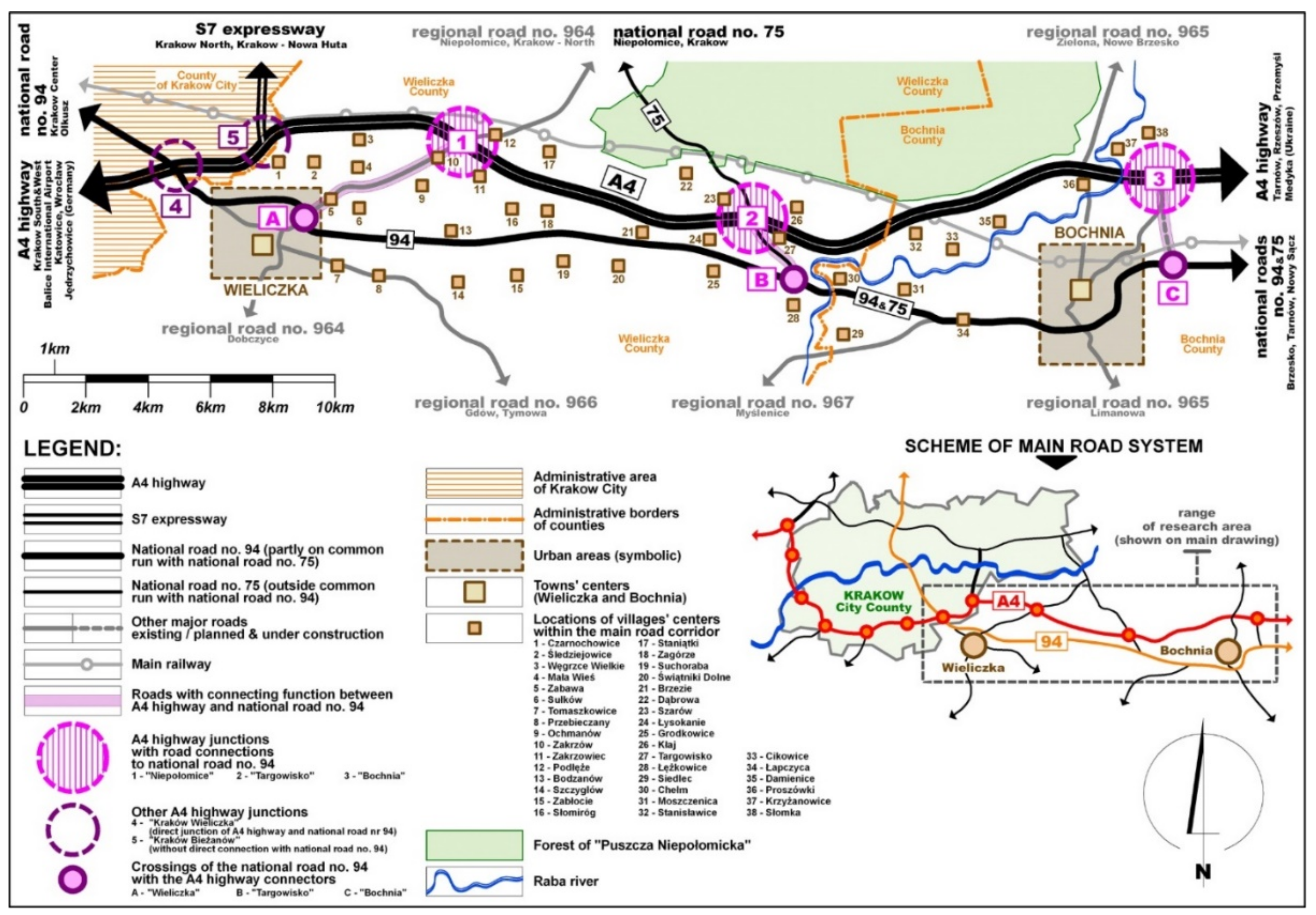
The zone of the road corridor that connects the eastern zone of Kraków with Bochnia (“Kraków East–Bochnia”) was chosen for investigation, as it was a space that was a part of a metropolitan area and was under a strong influence of a large city, and it was a part of a transport and circulation corridor of key national and even international significance (the Pan-European Transport Corridor 3 that connects Dresden, Germany with Kyiv, Ukraine, across Poland). The area under study had the form of a strip that was around 35 km long and around 6 km wide. In the west, it reaches to Kraków’s city limits, and in the east—those of Bochnia, a city of medium size, which has strong functional and social ties with nearby Kraków. The strip included a road corridor, which at the time of study was formed by the following main elements:
- –
Highway A4, along with the following junctions (from west to east): “Kraków Wieliczka” (numbered 5 in figures); “Kraków–Bieżanów” (4); “Niepołomice” (1); “Targowisko” (2); “Bochnia” (3);
- –
National road 94 (along the eastern section it overlaps with the course of national road 75), along with major intersections with other higher-class roads: the “Wieliczka” intersection (marked A in figures), with regional (voivodeship) road 964; the “Targowisko” intersection (B), with national road 75; the “Bochnia” intersection (C) with a county road leading northward (under construction during the study);
- –
Highway connectors that link highway A4’s junctions with main intersections along national road 94: connector “A-1” between the “Wieliczka” intersection (A) and the “Niepołomice” highway junction (1)—within the course of voivodeship road 964; connector “B-2” between the “Targowisko” intersection (B) and the “Targowisko” highway junction (2)—within the course of national road 75; connector “C-3” between the “Bochnia” intersection (C) and the “Bochnia” highway junction (3)—within the course of an existing county road and its incomplete section.
The course of the “Kraków East–Bochnia” road corridor has been presented against the background of the location of cities and the settlement system in
Figure 1. An agglomeration railway with its stations and passenger stops is an integral part of the entire transport corridor along its section between Kraków and Bochnia. However, this study focused only on elements of the road network, while the railway was not investigated due to its unchanging form and role within the corridor. This role was limited solely to passenger transport, especially in the form of commuter rail used by residents of the external part of the Kraków agglomeration between Kraków and their respective places of residence. For this reason, the significance of rail transport as an economic activation factor and of an impulse for the investigated transformation remained marginal but can be investigated in the future.
The subject of this study was the impact of the transformation of the transport layout within the road corridor on the development and transformation of the area within said corridor. This problem tied together transport-related, functional and spatial matters. The basic factor that reflected the state of the area under analysis and the scale and character of the transformations within it was the location of large forms of economic activity with a supra-local impact. It was assumed that the location of such sites could have been conditioned by good accessibility and access to proper transport and circulation infrastructure (including ease of access for clients, employees, deliveries and shipments of goods and resources). The study did not delve into the construction of new and the expansion of existing housing zones, found to primarily consist of extensive single-family houses. It was assumed that the presence of the transport corridor’s elements has a considerable impact on the development of this form of use, but new housing complexes are typically almost always sited outside of the immediate vicinity of major roads (especially highways) due to considerable nuisance to potential residents and the low attractiveness of such settings.
The housing development present in the area under study was also a continuation of the built-up areas of former villages and suburban areas of Wieliczka, Bochnia and Kraków and had a scattered layout. As a criterion of including a specific building- or area-associated economic activity, it was assumed it had to be no further than 200 m away from the main road (actual distance traveled), as well as the means by which it is connected to said road—either directly or by a single intermediate road at most (an internal or public road). Large forms of economic activity included commercial retail and service uses (including vehicle-related services, such as gas stations, gastronomic establishments, repair workshops, hotels, etc.), production plants, storage facilities and storehouses, as well as other supra-local services. All public services were disregarded (administration, education, culture, religion, sports and recreation, healthcare) and small trade services and retail businesses—elements whose functional significance was confined to their immediate vicinity, which were situated either directly adjacent to the roads or solely within existing development structures of villages and suburban areas.
The study was performed from a retrospective standpoint, which covered the last decade. The time period investigated ranged between the year 2012 (the year when the entire highway A4 section, running eastward from the “Kraków Wieliczka” junction and Tarnów, through Bochnia, was opened) and 2022 (the present, in a perspective of 10 years since the opening of the highway A4 section between Kraków and Bochnia). The period of ten years presented allows for tracing the changes in terms of the quantity and location of sites (buildings and areas) associated with supra-local economic activity located in the immediate vicinity of major roads (highway A4, national road 94 and the three highway connectors). These changes are symptoms of distinctive phenomena and processes linked to the development and transformation of built-up areas following the extension of the road network within the analyzed “Kraków East–Bochnia” corridor.
Large economic activity site placement analyses were conducted for the years 2012 and 2022, namely for the years that marked the beginning and end of the time period under study. For 2012, the analysis only covered national road 94—the base element of the road corridor analyzed during this time. The analysis of the end state (for 2022) included, holistically: highway A4, national road 94 and three connectors (A-1; B-2; C-3) that linked these roads. The identification of economic activity sites for 2022 was performed based on field inspections (January 2022), while for 2012, using GIS tools in conjunction with a comparative analysis of satellite images and a detailed analysis of available cartographic resources, especially topographic maps drawn to a scale of 1:10,000. The study did not cover the surroundings of the Wieliczka and Bieżanów junction as they are a part of Kraków and Wieliczka’s suburban zone. The Bieżanów junction does not provide a direct link to the road network of this region, merely giving access to Kraków’s beltway from highway A4 from the east.
3. Results
The analysis of the road corridor under investigation allowed for identifying that its elements, namely highway A4 and national road 94, had a largely parallel course, oriented along the east–west direction. Both roads crossed at the “Kraków Wieliczka” junction, located within Kraków’s city limits. The distance between the highway and national road 94, when measured in a straight line, ranged between 0.9 km (near the villages of Brzezie and Łysokanie) and 5.3 km (near Bochnia), whilst the distance measured along the length of the connectors was 6.0 km (A-1), 2.6 km (B-2) and 3.2 km (C-3). Connectors A-1, B-2 and C-3 had an essentially parallel course relative to highway A4 and national road 94. However, it should be mentioned that their course was not perfectly parallel to these roads (especially in the case of connector A-1, which deviated slightly more to the east).
The distinctive layout of the main elements in the “Kraków East–Bochnia” road corridor allowed the authors to present it as a model (
Figure 2). The model of the road corridor’s structure encompassed two linear, parallel elements, which represented highway A4 and national road 94, as well as three transverse elements, highway connectors A-1, B-1 and C-3, which linked the highway and the national road. The course of the parallel roads was divided into sectors of equal length (sectors 1–18) of 2.0 km, which facilitated quantitative research and the parameterization and documentation of findings. The presence of essential objects and elements was identified in the model: the junctions of highway A4 (“Niepołomice”—1, “Targowisko”—B and “Bochnia”—C) as well as cities (Wieliczka and Bochnia) and villages located within the corridor. Between the highway junctions (1, 2 and 3) and their corresponding intersections on the national road (A, B and C), the course of highway connectors A-1, B-2 and C-3 was marked. The connectors were located in the following sectors: connector A-1—sectors 3–6, connector B-2—sectors 10–11 and connector C-3—sectors 17–18.
The precise identification of areas of high economic activity within the “Kraków East–Bochnia” road corridor allowed for assigning their specific numbers to each sector. The superimposition of quantitative data on the road corridor model presented the structure of the distribution of economic activity sites within the corridor, which has been presented in
Figure 2, comparing the state of 2012 (for national road 94) and 2022 (separately for national road 94, separately for highway A4 and together for the entire road layout). In the study, the road corridor was investigated in sectors 3–18. Sectors 1 and 2 (namely the section from the “Kraków Bieżanów” junction on the highway and to Wieliczka on national road 94, whose length was 4 km) were deliberately ignored as it formed a part of the heavily urbanized suburban zone of Kraków and Wieliczka. It was assumed that the factor that determined the siting of large economic activity sites in the two first sectors was close proximity to Kraków as a metropolitan city and was less influenced by placement along a major transport arterial.
The quantitative findings have been presented in
Table 1. The road corridor sectors analyzed (sectors 3–18) were assigned with their respective amounts of large economic activity sites identified over the course of the study. The amounts for 2012 and 2022 were compared and were assigned to each element of the road corridor. In the table, sector groups that formed strips associated with the three highway connectors (connector A-1: sectors 3–5, connector B-2: sectors 10–11 and connector C-3: sectors 17–18). The comparison for the years 2012 and 2022 allowed for identifying the changes that occurred during this decade. An increase in the number of large economic activity sites was observed in 13 out of the 16 analyzed sectors, with the increase ranging between 33% (an increase from 6 to 8) to even 1500% (an increase from 0 to 15). The absence of change was observed only in three sectors (4, 9 and 16). The overall increase in the number of large activity sites within the corridor in the years 2012–2022 was 144% (from 68 to 164). An analysis of data compared for sectors associated with highway connectors (A-1, B-2 and C-3) also yielded crucial observations. The data for 2022 showed that these sectors featured a total of 130 large economic activity sites out of the 164 in the entire corridor, which is close to 80% of all such sites in the area under analysis. This state stemmed from the economic activation of the zones around new highway junctions and intersections between connectors and national road 94. It is notable that, after the opening of highway A4 (along the Kraków–Bochnia route), the zone of the “Bochnia” junction saw the emergence of economic activity zones that featured 15 large activity sites, with the same number of such sites in the area of the “Targowisko” intersection (near national road 94 and highway connector B-2). In addition, the sectors located outside of the areas of the highway connectors (7–9 and 12–16) did not display much economic activity. Although an increase in the number of large economic activity zones was observed in some of these sectors, this increase was notably smaller than in sectors associated with highway connectors.
The graphical interpretation of the distribution of large economic activity sites within the road corridor and quantitative data listed in
Table 1 allowed for building a model of the “Kraków East–Bochnia” road corridor that would account for essential transport and functional and spatial determinants—separately for 2012 and 2022 (
Figure 3). The model of the road corridor for 2012, constructed on the basis of the distribution of large economic activity sites along national road 94 (which was the main transport element in the corridor at the time) reflected the linear relationship between the number of such sites and the distance from Krakow, as the agglomeration’s central element. The highest concentration of such activity sites was present in Kraków’s suburban zone, between Wieliczka and the “Kraków Wieliczka” highway junction that already existed at the time. As one moved further east, the number of activity sites along national road 94 noticeably decreased. It was possible to observe minor concentrations of large economic activity sites in the area of the “Targowisko” intersection already in 2012, as at the time it was the location where two major national roads intersected. It can thus be stated that, in 2012, the “Kraków East–Bochnia” road corridor had a longitudinal layout, based on an axis defined by the course of national road 94. The distribution of large economic activity sites along this axis demonstrates the clear gravitation toward the agglomeration’s center, namely Kraków.
The investigation presented in this paper demonstrated that the extension of the transport network in the “Kraków East–Bochnia” road corridor, essentially based on opening a highway segment with three junctions, led to a complete remodeling of the corridor’s development structure. The original longitudinal layout, based on the course of national road 94, was transformed into a transverse layout in which three highway connectors (A-1, B-2 and C-3) became dominant, along with areas around new highway junctions (1, 2 and 3) and zones near major intersections with the national road (A, B and C). It can thus be concluded that the transformation of the transport layout in the road corridor under investigation had a direct impact on the functional and spatial model of the area, which transformed significantly over the decade under investigation—and which appears to be a relatively short period. In the study, the authors focused on concentrations of large economic activity sites, treating them as a symptom of relevant processes. These activities play a major role in the functional sphere—primarily as service and production buildings. The example of the “Bochnia” and “Targowisko” highway junctions and the “Targowisko” intersection (on national road 94) confirmed that new economic activity sites can sometimes take on the form of local centers and initiate the concentration of larger development structures. Because of this, the placement of such activity sites can also potentially have considerable significance.
4. Discussion
Based on a detailed analysis of cartographic resources, satellite images and field research, it can be assumed that the geometry and structure of the road layout within the “Kraków East–Bochnia” transport corridor is characteristic for multiple areas, especially those tied to metropolitan centers and agglomerations of large cities. This merits a continuation of the investigation in other fragments of existing road corridors. The form of the corridor under analysis and the layout of its roads is undoubtedly a consequence of the general development of road transport across the entire country. This process is dynamic both in Poland and in other nearby countries such as Slovakia, the Czech Republic and Hungary, where the highway network is developing at a rapid pace, but this development began much later than in Western Europe, the United States, Canada and highly developed countries in Asia.
The results of this original study of the “Kraków East–Bochnia” transport corridor are mostly aligned with the findings of other researchers. Davies and Baxter [
20] analyzed the Macleod Trail through the Canadian city of Calgary. They demonstrated that the road was the main axis of development for a part of the city and featured major commercial and public services. Davies and Baxter also noted the variability in service building types along the road section they analyzed, as well as a clear drop-off in the density of these services the farther one was from the road corridor’s axis—which they argued was typical for most North American cities. Berry [
21] came to a similar conclusion while studying the placement of service concentrations in the highway 99 corridor between Seattle and Everett in Washington, US. This corridor was investigated as a business ribbon, namely a transport route that attracted businesses following the principle of ribbon-oriented development.
The increase in development density, especially near highway junctions and in the suburban zone serviced by a highway, was also observed in studies conducted in Spain [
22,
23]. These studies noted the migrations of Barcelona’s residents and the change in settlement patterns due to the modernization of the transport network. They pointed that distance and access to highway junctions and railway stops is a significant factor in this process. This attests to the considerable impact of highway network development on suburbanization and the rise of suburban populations, which is a direct consequence of the extension of road networks and the enhancement of their effectiveness. Percoco [
24] highlighted the key significance of highway junctions in the development of urbanized areas in Italy.
Studies of cities and their surroundings clearly indicate that access to highways is a deciding factor in the siting of businesses. This principle was also demonstrated in this study of the “Kraków East–Bochnia” corridor, especially in relation to the area around the “Wieliczka” and “Bochnia” highway junctions, which saw a dynamic increase in the number of new real estate development projects, and this process appears to be following a positive trend. Its consequences include a change in the model of the functio-spatial structure in the entire road corridor, in which the development of built-up areas was found to be closely connected to the course of the highway and the location of its junctions and connectors. Similar studies demonstrated the high significance of road transport corridors on the development of cities along their course [
25]. Putra Pratama focused on cities located within the metropolitan area of Jakarta, which, similarly to the core city, develop due to having good accessibility to highways. In their opinion, metropolitan centers of this size exert a strong influence on the development of other urban areas within a radius of 40–50 km from the metropolitan center, which indicates the existence of a relationship between the city’s range of influence and its size. It appears that spatial planning and urban design following the concept of highway-oriented development can form a comprehensive trajectory for planning urbanized areas based on the precepts of sustainability [
26]. A study of Beijing’s transport and circulation networks also found a tendency for the development of the services system near highway junctions and connectors—as a distinctive feature of shaping space along major road network elements. The authors conclude that the development of the highway network has a greater impact on the transformation of Beijing’s suburban zones, rather than the central area of this city. This phenomenon is also tied with accessibility to a city’s individual functions via various means of transport, which significantly impacts urban development and the shaping of cities, suburban areas and entire regions [
27,
28].
The studies mentioned above provide arguments in favor of the statement that integrating the planning of the transport and circulation network, including the construction and development of highways, with spatial planning and development is crucial to the shaping of the broadly understood environment, especially that of built-up areas. The effective linking of these matters provides an opportunity to steer processes at the point of contact between elements of the road network and their adjoining built-up areas, with the objective being the optimal planning of cities, including metropolises, suburban areas and entire regions.
It is obvious that the principles of the construction and development of road transport systems and their accompanying development structures differ between developing countries (such as Poland) and those which are more advanced in terms of road infrastructure (such as Canada, the United States, China, Spain or Italy). According to the authors, this is a consequence of clear differences in the development of road infrastructure in individual countries and also results from different local and regional conditions, including the spatial planning system, which in various ways integrates the issues of transport and communication, as well as spatial development and transformation. The findings of studies conducted in Poland and in other countries lend credence to the argument that the processes and phenomena observed in high-class transport corridors are mostly universal.
5. Conclusions
The findings of the investigation of the “Kraków East–Bochnia” transport corridor presented in this paper present an interesting picture of transformations and mutual relations between the road network and its accompanying functio-spatial structure. The change from a longitudinal to a transverse model leads to the conclusion that the highway A4 section which opened in 2012, and especially its three connectors, became a new layout of axis for the concentration of large businesses—elements that, in functional and spatial terms, are key to the entire road corridor. The opening of this highway section thus became the primary determinant of a new transformation model for the entire road corridor.
It appears that the model presented (
Figure 3) correctly reflects the features of the road corridor that connects eastern Kraków with Bochnia and also corresponds to other similar corridors across Poland (e.g., corridors near Rzeszów, Wrocław, Częstochowa, Poznań and Gdańsk) and in other countries (e.g., in the Liptovský Mikuláš–Poprád strip in Slovakia, Budapest–Szeged in Hungary and Prague–Hradec Králové in the Czech Republic). This suggests that the phenomena and processes under investigation can be seen as universal, which also points to the possibility of controlling them at the spatial planning stage—which can support the desirable and more sustainable development of cities and regions and alleviate unavoidable negative consequences of the extension of road networks.
The following general and detailed conclusions were formulated as a result of this study:
- –
The opening of a highway section as a supplementation of an existing road corridor, as evidenced by the investigated fragment of the “Kraków East–Bochnia” corridor, led to the transformation of the spatial model of business siting from a “parallel” layout to a “transverse” layout—based on new elements of the corridor, namely highway junctions and connectors.
- –
After the opening of the investigated highway A4 section, the linear, simplified model of the distribution of businesses—linked with the course of national road 94—reoriented into a model dominated by service and production concentration areas, located near highway junctions and connectors between the new highway section and the previous transport layout.
- –
New, significant sites of economic activity of supra-local significance took on the form of either singular buildings or formed concentration zones with commercial services, production, storage and logistical uses.
- –
The road corridor fragment under study (“Kraków East–Bochnia”) was found to be similar in terms of structure, layout and size to other road corridors in Poland and other countries. For this reason, it can be considered a model structure, and the processes and phenomena that take place in it can be treated as universal.
- –
The findings of the road corridor under investigation can be useful in the analysis and forecasting of the consequences of road network extension, especially by means of highways that link large urban areas with peripheral zones, which can be utilized in rational spatial policy and sustainable spatial development.


