Article

Multivariate Statistical Analysis and Structural Sovereignty for Geochemical Assessment and Groundwater Prevalence in Bahariya Oasis, Western Desert, Egypt

by
Mohamed Abd El-Wahed
*,
Mohamed M. El-Horiny
*,
Mahmoud Ashmawy
and
Samar Abd El Kereem
Geology Department, Faculty of Science, Tanta University, Tanta 31527, Egypt
*
Authors to whom correspondence should be addressed.
Sustainability 2022, 14(12), 6962; https://doi.org/10.3390/su14126962
Submission received: 16 April 2022 / Revised: 19 May 2022 / Accepted: 2 June 2022 / Published: 7 June 2022
(This article belongs to the Section Sustainable Water Management)

Abstract

:
The Bahariya Oasis is an example of an extremely hyperarid environment and it is characterized by an extensive nonrenewable Nubian Sandstone Aquifer System (NSAS), which is deemed the crucial provenance for agrarian and national development ventures. The present work aimed to assess the groundwater occurrences in the NSAS, and to document the main factors that control the geochemistry of the groundwater in the Bahariya Oasis. Groundwater samples were collected from 52 locations in April 2019 and were analyzed for a total of 13 water-quality physicochemical parameters. A diverse geological and structural setup has greatly impacted the groundwater flow pattern and has diverted it towards the NE by the great Bahariya anticline structure, the ENE-oriented Bahariya mid dextral strike-slip fault, and NE-striking normal faults, while NW-oriented normal faults cause the groundwater to diverge perpendicular to the groundwater flow lines. The groundwater is highly contaminated by trace metals (Fe2+ and Mn2+), which exceed the permissible limit for different purposes. Conventional graphical plots and geochemical modeling integrated with multivariate factor analysis (FA) revealed that the chemical composition of the groundwater is strongly affected by its interaction with the lithologies of the NSAS. The dissolution of aquifer host rocks (carbonates and iron oxides) and chloride salts through the infiltration of groundwater, and the incorporation of cations by the ionic exchange of Na+ by Ca2+ in clay minerals, emerged as worthy mechanisms for the groundwater development. Furthermore, the region’s rapidly increasing population, agricultural expansion, and the associated anthropogenic practices have generated a need for groundwater-quality assurance as a prime source of the water supply. Consequently, reducing the effects of the NSAS’s unsustainable extraction requires long-term monitoring and the ongoing evaluation of the groundwater.

1. Introduction

In the Egyptian deserts, such as the areas of the Western Desert, there has recently been a lot of attention paid to agricultural developments and sustainable growth, and their need to be consistent with the most important goals of both the National Water Resources Plan 2017 [1] and the Government of Egypt’s Strategy for Sustainable Agricultural Development 2030 [2]. The Sustainable Agricultural Development Plan for 2030, which was launched by the Ministry of Agriculture and Land Reclamation in the late 2000s, takes into account all facets of agricultural production. In terms of water conservation, the aim was to increase water-use production from 50% to 80% by 2013, which would “save volumes of water measured at 5.3 and 12.4 billion m3 by 2017 and 2030, respectively and also allow for a 5 million feddan expansion” [2]. Such fanciful numbers fail to understand the distinction between the water-use potency on the plot and in the NSAS system, which is a problem that the MWRI described and discussed as early as the mid-1990s.
Any debate as to the ways to improve production and how to fulfill it are inevitably linked to the question of the overall water availability. Since the only provider source of water in these dry areas is the groundwater abstracted from the Nubian Sandstone Aquifer System (NSAS), which is designated as a nonrenewable groundwater resource [3], the groundwater system requires appropriate assessment and management procedures for permissible usage and long-term production. The overuse of groundwater from the NSAS, which lacked a comprehensive management plan, resulted in significant water deterioration across the area [4]. Groundwater hydrochemical characteristics are used to track groundwater flow processes, and to identify the mechanisms that govern groundwater chemistry and the geochemical processes that impact the groundwater quality. Groundwater mineralization is influenced by natural elements, including the aquifer lithology, the overriding geological structure, geochemical operations within the aquifer, and the quantity of the groundwater flow from the recharge to discharge areas across its passage, as well as anthropogenic activities, groundwater overpumping, unregulated well drilling, and unrestricted agricultural and industrial activities [5,6,7]. Understanding aquifer geochemistry and identifying the causes of groundwater depletion are vital for regulating and improving groundwater resource management [8].
The Bahariya Oasis in the Western Desert is undergoing a continuous lowering of the groundwater level as a result of unplanned water control, which causes severe soil salinization, resulting in a reduction in the quality and productivity of related resources [9,10,11]. Such environmental concerns have arisen as a result of the rapid expansion of agricultural practices, which has resulted in a significant increase in the use of groundwater. As a result, it is critical to continuously consider the aquifer characterization in the Bahariya Oasis in order to define the area’s areal distribution of aquifer layers and to assess the groundwater potentialities.
Groundwater chemistry studies certainly benefit from multivariate-statistical-analysis approaches [12,13]. These approaches aid in the classification of groundwater and in the identification of the main factors that influence the groundwater chemistry [14]. To interpret the hydrochemical parameters, these approaches might be combined with graphical representations. They are often regarded as the optimum and, in many cases, the only viable option for assessing massive amounts of hydrochemical data. Geochemical modeling is often employed for the study of the water–rock interaction. Its goal is to identify the chemical processes that take place along a flow channel. The combination of hydrochemical-interpretation visualizations, multivariate statistical analysis of the groundwater chemistry, and inverse geochemical models is an effective approach for assisting the geochemical process and identifying the main factors that control the groundwater quality in their respective study areas [8,15,16]. The main objectives of this study were to emphasize the roles of geologic structures in monitoring groundwater flow regimes, to identify the hydrochemical characteristics and the processes that control the groundwater quality, and to identify the mineralization of the groundwater in the Bahariya Oasis.

2. Study Area

The Bahariya Oasis is a natural oval depression in the midst of Egypt’s Western Desert, spanning approximately 2200 km2 and positioned NE–SW (Figure 1a). The area is dominated by hyperarid climatic conditions [17]. The oasis’s population of 34,000 people is mostly focused on agriculture, with farming settlements scattered over the landscape. Scientists are interested in it because of its economic value, industrial activity (mostly iron ore resources), tourism, and vast reclaimable fields.
A highly precise Phased Array type L-band Synthetic Aperture Radar (PALSAR) dataset (12.5 m resolution) was employed to analyze the geomorphic properties of the Bahariya, and it was processed using ArcGIS 10.6. The topography of Bahariya is marked as a flat rough, rocky surface owing to the weathering of hard rocks, and it ranges in height from 71 to 370 m above mean sea level (AMSL) (Figure 1b). The Bahariya Oasis is divided into three main parts: northern, central, and southern. The northern and southern parts are flat, while the central sector is rocky and higher in altitude. The plateau surface, bordering escarpments, oasis floor, wadis, residual hills (questas), alluvial fans and terraces, volcanic cones and sheets, sabkhas, sand sheets, and sand dunes are the most notable geomorphic features [18].
According to Egypt’s Strategy for Sustainable Agricultural Development 2030, the Bahariya Oasis is subject to about 80 km2 of the 1.5-million-acre project, and the nonrenewable groundwater withdrawn from the Nubian Sandstone Aquifer is the only source of water for agriculture and residential use. Thus, decisionmakers must work to sustain, enhance, and plan groundwater-quality investigations, as well as identify effective ways to reduce both natural and human pollutants.

2.1. Geological Setting

With regard to the subsurface sequence, from bottom to top (Table 1 and Figure 2), a detailed stratigraphic conception of the Bahariya Oasis is as follows:
  • The Precambrian basement is made up mostly of igneous and metamorphic rocks (1391–1718 m) [19];
  • Intercalated siltstone, sandstone, and clay constitute 458 m-thick Cambrian rocks;
  • Cretaceous rocks: 660 m from the bottom to the top, and there are four formations:
    (a)
    The Bahariya Formation (Lower Cenomanian). This formation is made up primarily of flat-lying fluviatile sandstone and it serves as the oasis’s floor (total: 705 m thick, with a maximum exposed thickness of 173.5 m). The Bahariya Formation is marked by abundant intercalations of ferruginous layers [20,21].
    The thickness of the Bahariya Formation ranges from 90 m in the central section of the depression, to more than 170 m in the northern parts (Gabal El Dist) (Figure 3d). It displays a portion of the Bahariya Formation (Cenomanian, Upper Cretaceous) and is overlain by the Naqb Formation (Middle Eocene). In the Sandstone Hills region and at Gabal Miteilaa Radwan, the lower sandstone member is well exposed. In the northeastern scarps, the Bahariya Formation is surmounted by Middle Miocene basaltic rocks at Gabal El-Hefhuf.
    The Black Desert is located 50 km south of El-Bawiti, is composed of conical-shaped mountainous hills, and is fundamentally related to the Bahariya Formation (Cenomanian ferruginous sandstone and chalky clays). The majority of these hills are covered with ironstones and dolerite crystals (Figure 3e);
    (b)
    The El-Heiz Formation (Upper Cenomanian). This formation, which is unconformably topped by the El-Hefhuf Formation, is composed primarily of fossiliferous limestone, shale, calcareous sandstone, and marl (Figure 3f) [19,22,23]. The El-Heiz Formation reaches a maximum thickness of 40 m in the southern part of the depression at Naqb El Sellem, and then drops to around 12 m in the northern scarp;
    (c)
    The El-Hefhuf Formation (Campanian–Turonian). This formation is a 130 m-thick succession of light-brown siliceous dolomite, dolomitic limestone, and sandstone, and it unconformably superimposes the El-Heiz Formation (Figure 3g) near Gabal El-Hefhuf [24]. At the Bahariya north scarp, the El-Hefhuf Formation is absent, and the Bahariya Formation is unconformably overlain by Lower Eocene limestones [25]);
    (d)
    The Khoman Formation (Maastrichtian). This formation is from 30 to 45 meters thick and consists of huge white chalky limestone that covers most of the Bahariya southern scarps [19,26,27]);
  • Paleocene rocks are clearly identified by: (a) The Tarawan Chalk (20–30 m thick), which is composed essentially of chalky limestone and limestone and which is naked to the south of the depression; and (b) The Esna Shale, which is featured in the plateau’s southern escarpment (Figure 3h), separating the Bahariya and El-Farafra depressions [19,23]);
  • Eocene rocks. They constitute the Farafra and Nqab formations and represent the top of the plateau that surrounds the Bahariya depression:
    (a)
    The Farafra Formation (Lower Eocene), which is featured in the eastern and southern escarpments of the depression. Only the upper member of the Farafra Formation is visible;
    (b)
    The Naqb Formation, which mainly comprises pink to violet Nummulitic dolostone and limestone accumulations (Figure 3i). Iron ore deposits have emerged in the northeastern Bahariya Depression (the El-Gedida, Gabal Ghorabi, Nasser, and El-Harra districts), where iron-bearing solutions have substituted the Naqb’s carbonate rock [28]);
    (c)
    The Qazzun Formation, which is constituted of chalky Nummulitic limestones with firm dolomitic-limestone ball-like concretions (7–10 km-wide band);
    (d)
    The El-Hamra Formation (Middle-Upper Eocene), which is on the eastern plateau of the depression (63 m of fossiliferous limestone deposits) [29];
  • Tertiary rocks comprise: (a) Volcanic rocks. Numerous isolated basalt outcrops in the northern and central parts of the depression (Measera, Mandisha, El-Hefhuf, and Basalt Hills), sheets of Oligocene-aged volcanic rocks, and mainly extrusive basalt and dolerite cap the sedimentary deposits (Figure 3j,k). A WNW-oriented dolerite dike and a thin laccolith may be seen at Gabal El-Hefhuf; (b) Ferruginous grits and layers of sandstone and clayey sandstone constitute the Radwan Formation [19,25,29]); (c) The Qatrani Formation (Oligocene) is found in the northeastern plateau and represents the weathering products of various Cretaceous and Eocene rock groups;
  • Quaternary rocks include: (a) aeolian sands, forming dispersed seif dunes; (b) sabkhas and salt deposits, established owing to the infiltration of water from naturally flowing springs and wells on the depression surface; (c) playa deposits, which are made up mostly of fine sand, silt, clay, gypsum, and halite, and are found in freshwater depressions.
Table 1. Composite stratigraphic section of El-Bahariya Oasis (compiled from [23,30]).
AgeRock UnitThickness (m)Lithology
Quaternary Gravel terraces, talus, sabkha and playa deposits, wind-blown sand, and alluvium
Early Miocene (16–20 Ma)Basalt flows and sills20Olivine basalt
OligoceneQatrani Formation Weathering products of the different rock units of Cretaceous and Eocene ages and occurs in the northeastern plateau
OligoceneRadwan Formation40Ferruginous grits and beds of pale-brown to yellow sandstone and clayey sandstone
Unconformity
Middle and Late EoceneEl-Hamra Formation63Fossiliferous limestone beds with a few clastic intercalations with inward dips of 10–40°
Middle EoceneQazzun Formation32Chalky Nummulitic limestones with ball-like concretions of hard dolomitic limestone
Unconformity
Middle EoceneNaqb Formation(Ghorabi iron ore member)68Pink to violet Nummulitic dolostone and limestone forming isolated hills
Lower EoceneFarafra Formation34Limestone
Upper Paleocene–Lower EoceneEsna Shale20Greenish-gray to gray shale
Lower Paleocene Tarawan Chalk20–30Chalky limestone and limestone
Unconformity
Early MaastrichtianKhoman Chalk30–45Massive white chalky limestones
CampanianEl-Hefhuf Formation120Dolostone and sandstone with sandy clay intercalations
Unconformity
Late CenomanianEl-Heiz Formation30Clastics with carbonate interbeds and a dolostone member at the top
CenomanianEl-Bahariya Formation170+Variegated, cross-bedded sandstone
Cambrian Cambrian rocks458Intercalated siltstone, sandstone, and clay
Pre-Cambrian Metamorphosed igneous basement
Finally, the iron ore localities in the Bahariya are El-Gedida (Figure 3l), Nasser, El-Harra, and Ghorabi. Ref. [31] identified three genetic forms of El-Gedida iron ore: (1) massive hydrothermal metasomatic; (2) porous or massive, resulting from mobilized iron and manganese redeposits in freshwater lakes, probably from biogenic activity; and (3) a result of the weathering of glauconitic clays and sands, typically with an oolitic or pisolitic form.

2.2. Structural Setting

The Bahariya depression is deformed by an NE-trending right-lateral wrench-fault structure (Figure 2), which is associated with several doubly plunging folds and extensional faults [19,32] of the large Syrian Arc belt [19,32,33,34,35,36,37,38,39]. The faults trending E-W, ENE, and WNW are the masters and are characterized by a dextral sense of movement, while those of the NS, NNW, and NNE directions are subordinate, with a sinistral sense of dislocation [32].
The Bahariya Oasis depression is essentially a huge anticline that runs NE–SW, from Gabal Ghorabi in the north to El-Heiz in the south, passing through the depression’s middle hills (Figure 2). Folding occurred after the deposition of the thick Cenomanian Bahariya clastics [30].
The Bahariya great anticline consists of a number of major anticlines (e.g., El-Gedida, Naqb El-Harra, Ghorabi, El-Tebaniya, Heiz, and Ris), major synclines (e.g., El-Hefhuf, Miteilaa Radwan, and Tobog), and one monocline (Sandstone Hills), as well as dozens of small-scale folds. The dips of bedding are as high as 55° in the north (Figure 2).
One of the prominent wrench faults, cutting through the Bahariya depression and associated with severe folding on both sides of its trace, is a major dextral strike-slip fault that was termed the Bahariya mid fault by [32]. The Bahariya great anticline is markedly displaced by the Bahariya mid fault.
In the northern segment of the Bahariya Oasis occurs the El-Gedida fold, and the Gabal Topog and Gabal Ghorabi structural segments. The El-Gedida anticline (Figure 2) is a major SW-plunging anticline that occurs in the central part of the mine area. The iron ore beds show a diagnostic fold in profile view, with axes parallel to the major fold. The El-Gedida anticline, interpreted by [36] as a wrench-related folding, indicates that the wrenching ceased during the Late Eocene time.
The Gabal Tobog fault is an NE-striking dextral strike-slip fault (Figure 4). Two phases of movement were recognized on the fault surface by [19]. The first displacement occurred prior to the deposition of the Naqab Formation and resulted in the complete erosion of the El-Hefhuf Formation, which was located on the southern side of the fault at a higher structural elevation (hanging wall). The second movement took place after the deposition of the Naqab Formation, and this is because the fault split the Naqab Formation northward of Naqb El-Harra on the eastern plateau (Figure 4a).
In Naqab El-Harra, and to the south of the Gabal Tobog fault, there is an NE-striking reverse fault that is associated with a hanging-wall anticline in the Bahariya Formation (Figure 4a). In the eastern plateau, part of this anticline is exposed along the new road cut into Naqab El-Harra (Figure 4b), and the folded beds are displaced by a WNW-striking normal fault (Figure 4c).
To the south of Gabal Topog, there are three hills along one line, and mainly of the Bahariya Formation overlain by the El Heiz Formation. These hills occur as three major doubly plunging NE-trending synclines (Figure 4a,d), with the largest syncline displaced by an NNE-striking normal fault (Figure 4d), whereas the smallest syncline is displaced by an E–W striking normal fault. To the north of these synclines, there is a major doubly plunging anticline along the same line as the synclines. These major doubly plunging asymmetrical synclines and anticline, together with the El-Gedida and Naqab El-Harra anticlines, are characterized by right-stepped en echelon sequencing (Figure 4a), perhaps because of a Late Cretaceous right-lateral shear couple.
A small manmade exposure in the Upper Bahariya Formation to the west of Gabal Topog shows an overturned fold (first documented in this study). Variegated clay, shale, and sandstone constitute the majority of these rocks. The fold axis plunges towards the NE, and its overturned limb is displaced by an NE-striking dextral strike-slip fault (Figure 4e,f).
The Gabal Ghorabi structural segment is affected by the ENE-striking Ghorabi fault (Figure 5a). This dips 65° toward the south, cuts the central part of Gabal Ghorbi, and displaces its southern part downward. Along the Ghorabi fault, [19] identified two phases of movement. The first is a right-lateral strike-slip displacement that occurred post-Cenomanian and before the Middle Eocene, leading to a southward steep dip of the Bahariya Formation on the southern section of the fault, as well as the creation of a reverse fault and an NE-trending anticline and NE-striking normal faults in the Bahariya Formation (Figure 5b,c). These normal faults dip moderately (45–50°) toward the NW and SE (Figure 5b–d). The SE-dipping faults displace the NW-dipping ones. During the second movement (post-Middle Eocene), the Middle Eocene Naqb Formation (e.g., iron-rich beds) was southerly displaced along the Ghorabi right-lateral strike-slip. This movement led to the development of several doubly plunging anticlines and synclines, as well as monoclines trending NE–SW, and they have a right-stepped en echelon arrangement (Figure 5e). The Gabal Ghorabi structural segment is made up of multiple normal-slip faults that strike WNW to NW and are arranged in an echelon. Displacement along these normal faults during the second movement (post-Middle Eocene) generated various horst-and-graben formations, as well as many WNW-plunging anticlines and synclines (Figure 5f–h).
The Gabal El-Hefhuf structural segment occurs in the central part of the Bahariya depression, along the ENE-oriented Bahariya mid fault (N50°E/75°NW) and the related folds (Figure 6a). Gabal El-Hefhuf represents the downthrown side of the Bahariya mid fault. Gabal El-Hefhuf occurs as a major doubly plunging hanging-wall syncline dissected by several NW-striking normal faults. The most conspicuous NW-striking fault is that between Gabal El-Hefhuf and Gabal El-Basalt (Figure 6b). Another NW-striking normal fault displaces Oligocene basalt in Gabal El Engleez (Figure 6c) and forms a thick bed of breccia parallel to the fault plane.
The Gabal El-Hefhuf hanging-wall syncline (Figure 6d), and the small right-stepped en echelon anticlines and synclines to the west of Gabal El-Hefhuf, are directed east–northeast, subparallel to the Bahariya mid fault, but they shift directions in places and create an acute angle with it. The Upper Cretaceous rocks of Gabal El-Hefhuf are pierced by an NW-oriented right-lateral strike-slip fault that displaces the axis of the hanging-wall syncline by up to 1 km (Figure 2).
The Gabal Miteilaa Radwan structural segment (Figure 2) occurs along the Bahariya mid fault and consists of several ENE-oriented right-stepped en echelon plunging anticlines and synclines (Figure 6e) that form acute angles with the main plane of the Bahariya mid fault.
The Sandstone Hills form an ENE-oriented monocline and have steep flanks, with a dip-angle range between 35 and 55° (Figure 2). According to [19], the existence of a deep-seated ENE-oriented fault beneath the Sandstone Hills contributed to the creation of the monocline.
To the west of the Sandstone Hills, on the southern part of the Bahariya depression, there are two large NE-oriented doubly plunging anticlines (Ris and Heiz) in the Upper Cretaceous rocks. These folds generate an acute angle with the Sandstone Hills monocline’s continuation and the Bahariya mid fault.

2.3. Hydrogeological Setting

The Nubian sandstone, which is largely composed of continental clastic layers, and predominantly sandstone with shale and clays intermingled, is the biggest water-bearing source in the investigated region. The groundwater system is hydraulically attached to adjacent and inherent aquifers via feasible conduits that allow upward outflow. Therefore, the NSAS is defined as a multilayered “leaky” artesian aquifer system that operates as a coherent hydrogeologic framework [40]. According to [23], the NSAS hydraulic conductivity averaged 5.67 m/day, with values ranging from 0.46 m/day in the El-Bawiti area, to 10.88 m/day in the El-Heiz region (southern part). Furthermore, the transmissivity reached its lowest point (236 m2/day) in the north (El-Bawiti), and its highest point (3045 m2/day) in the south (El-Heiz). This is likely owing to the restricted development of shale deposition in the relevant aquifer in that direction, demonstrating the aquifer’s high potentiality and efficiency in the south.
Although the isotopic findings provide strong arguments that the fossil water of the basin was infiltrated during humid periods in the Late Pleistocene and Holocene times, it is likely that the leakage of water from the Nile into the NSAS can occur, but on very local scales [41]. The groundwater of the Nubian Sandstone aquifer was extracted at a rate of 56.6 million m3 per year, of which 50.7 million m3 per year was used to irrigate an area of 12,500 feddan, while the remaining 5.9 mcm/year was allocated for domestic purposes [42]. The exploitation of the groundwater is increasing each year. In the past 40 years, over 40 billion m3 of water has been extracted from the system in Libya and Egypt. This has produced a maximum drawdown of about 60 m and has led to the disappearance of almost all of the naturally flowing wells and springs [43].

3. Methodology

3.1. Sampling and Analysis

A random sampling scheme was initiated in April 2019 to explore the spatial distribution of the groundwater-quality parameters, and measurements of the water level from different wells were also achieved under static conditions to examine the head pattern and flowing directions. Concurrently, a total of 40 groundwater samples were taken from the confined deep aquifer, with documented depths ranging from 760 to 1170 m. Meanwhile, a total of 12 groundwater samples were gathered from the confined shallow aquifer, and their well depths ranged from 250 to 495 m (Figure 1b). The wells were chosen on the basis of the aquifers’ availability, geographical distribution, accessibility, and representation. These wells were operated for 10 min before gathering fresh samples of the relevant aquifer to eliminate any sluggish or polluted water. Samples were filtered through 0.45 μm-pore-diameter filter paper and collected in cleaned polythene bottles of a 1 L capacity. Then, samples were transported to the laboratory and maintained at 4 °C for subsequent chemical analysis.
In the preliminary assessments, the key physicochemical parameters comprising temperature (T °C), electric conductivity (EC), and total dissolved solids (TDS) were measured in situ using portable meters. Using the Direct Reading/2000 Spectrophotometer, the total quantity of iron as a trace element was also analyzed in situ. Major cations and anions, as well as Mn2+ as a trace element and NO3, were detected shortly after collection following Hach’s normal analytical techniques [44]. A handheld GARMIN GPS was used to acquire the geographic coordinates and elevation of the sampling locations. The data were checked for accuracy, and the computed ion-balance discrepancy was deemed to be within the acceptable range of 5%. Table 1 shows the general hydrochemical statistics for all the water samples collected from the different aquifers in the Bahariya Oasis, which can be used to understand their status and to determine their trend evolution.

3.2. Geostatistical and Geochemical Modeling

Semivariography and ordinary kriging (OK) were used to distinguish the spatial distributions of the hydrochemical variable concentrations in the groundwater system [45,46,47]. OK has emerged as one of the most popular linear unbiased estimators for constructing an appropriate spatial model in random-information areas while allowing for indiscriminate model uncertainty [47]. The spatial-variation maps were generated with ArcGIS 10.6’s Geostatistical mapping tool.
Geochemical modeling has been commonly used to assess the geochemical mechanism that causes groundwater to evolve [48,49,50,51]. The hydrochemical software PHREEQC is used to perform the mass-balance simulation, which shows chemical reactions and modifications in the chemical nature, such as the dissolution/precipitation of minerals and gases in the groundwater flow route [52]. Saturation-index (SI) results illustrate the propensity of minerals to dissolve or precipitate in the groundwater system. Geochemical modeling was performed using the following equation [53]:
SI = log (IAP/Kt);
where IAP is the ion-activity outcome in a solution of the disintegrated chemical species, and Kt is the mineral’s equilibrium-solubility component. The SI for any mineral phase with a negative value implies that the water is undersaturated with regard to that mineral and that it will dissolve until equilibrium is achieved, while a positive value denotes oversaturation, and that the mineral will precipitate.

3.3. Multivariate Statistical Analysis

Statistical investigation offers more attractive options in environmental science, though the results may deviate more from real situations. Using the XLSTAT statistical software, the 13 hydrochemical parameters (TDS, EC, pH, Ca2+, Mg2+, Na+, K+, HCO3, SO42−, Cl, NO3, Fe2+, and Mn2+) in both shallow and deep aquifers were correlated, and factor analysis (FA) was also performed. The Pearson’s coefficients (r) between the different ion pairs and their relation to TDS could be used as a first pointer for the types of salts that dominate the groundwater composition and the major salinization processes [54,55,56,57]. FA’s feasibility has been shown in prior groundwater-quality investigations [15,46,58].
Factor analysis (FA) is a multivariate statistical approach that is used to investigate the fundamental connections between multiple noted variables in terms of a potentially lower proportion of unobserved variables, which are referred to as factors, with minimal native-information loss. A correlation matrix is produced for the hydrochemical dataset, which designates the connectivity between variables. The generated parameters will represent the entire dataset’s properties. The overall variation (percent) was addressed using Kaiser’s criterion (eigenvalues > 1), and significant principal components (PCs) that constituted a percentage of variance > 10% were extracted from the original parameters. Varimax-rotation-generating factors (FA) were applied to these PCs to limit the impact of variables of little relevance. The FA provided the criteria of the most important water-quality measures and highlighted the relationship between the variables and sample locations in their geographical distributions, which were grouped together on the basis of comparable environmental conditions [15,46,51,59]. The eigenvalues and factor loadings of the correlation matrix were computed, and a scree plot was created. The variances and covariances of the variables were used to create the extraction factors. Prominent variables are defined as those with eigenvalues larger than one. Finally, the rotating mechanism enhances each variable’s loading on one of the extracted components while reducing the loadings on the other factors.

4. Results and Discussion

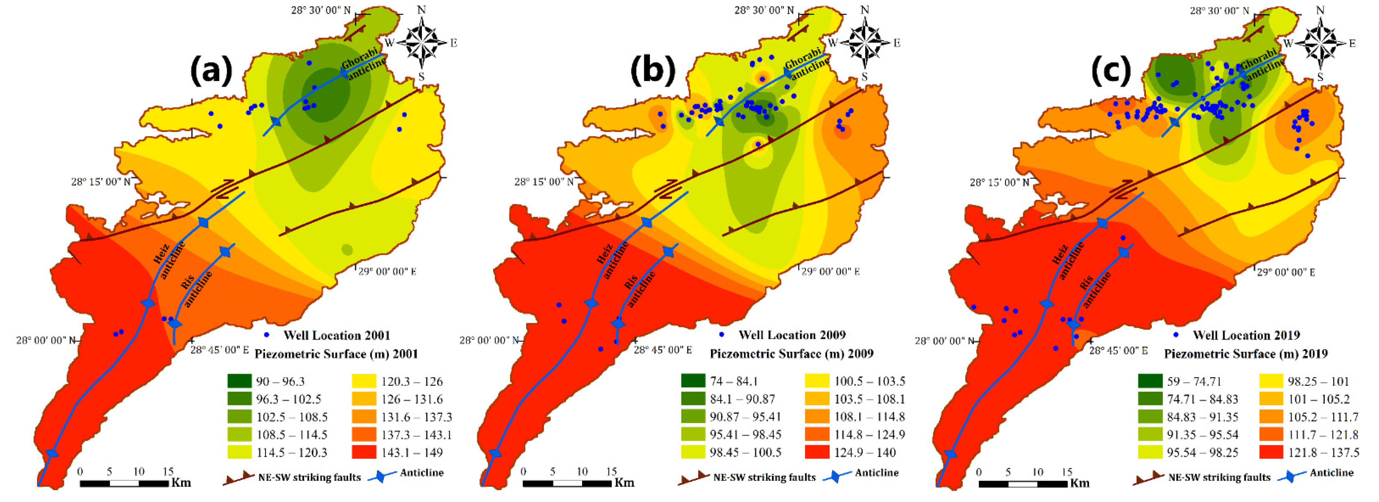
4.1. Groundwater Flow Pattern

The NSAS piezometric levels in the Bahariya Oasis were generated by using the available water-level observations over 2001, 2009, and 2019 (Figure 7). This level reached its peak during 2001 (149 m) in the El-Heiz region, while it dropped to 90 m and was mostly found in the northern part of the Bahariya Oasis (Figure 7a), suggesting that the pressure head of the NSAS in the southern part is higher than in the northern part. However, this level declined during 2009, and it ranged between 74 m and 140 m in the northern part and southern parts, respectively (Figure 7b). According to Egypt’s 2030 Strategy for Sustainable Agricultural Development, the Bahariya Oasis is home to about 20,000 acres of the 1.5-million-acre project, with the nonrenewable groundwater extracted from the NSAS serving as the region’s only source of water for irrigation and domestic use. This produced a noticeable decline in the piezometric level during 2019, and minimum values of 59 m in the northern part and 137 m in the southern part were recorded (Figure 7c).
The overall flow of the groundwater in the Bahariya aquifer is directed SW to NE, following the slope directions. The groundwater in the area flows in the same direction (SW–NE) as the groundwater in the Great NSAS in Egypt’s Western Desert [11,23,40,60,61,62]. Furthermore, due to significant groundwater pumping, the pressure head rises to the east, west, and south of the oasis, while the flow shifts to the east and west, approaching El-Bawiti town and its outskirts in the northern area [11,23].
The existing structural elements were greatly impacted by the groundwater conditions, as Bahariya is situated on the boundary between Egypt’s tectonically stable and unstable shelves [30]. Consequently, by comparing piezometric maps to the geological maps of the area (Figure 2), it was found that the anticlinal axis, with its associated strike-slip, reverse, and normal faults, as well as joint system, permits the movement of the groundwater to roughly follow the orientation of the anticline axis, plunging NNE.
Ultimately, it is reported that the piezometric head rises along structurally high areas, while the piezometric head decreases across structurally low areas. The wells drilled at El-Harra in 2001, 2009, and 2019 had maximum heads of 126, 115, and 111 m, respectively, whereas lower values of the head were matched with the wells that were drilled in the adjoining structurally low areas (El-Bawiti and its surroundings).

4.2. Hydrochemical Characteristics

Table 2 highlights the descriptive statistics of the hydrochemical parameters (lowest, maximum, average), together with the standard World Health Organization (WHO) values [63]. The following are the most commonly varying parameters for shallow aquifers: TDS (147.9–1740 mg/L); pH (5. 7–6.8); Ca2+ (7.7–128.7 mg/L); Mg2+ (9.8–196.1 mg/L); Na+ (20.1–334.7 mg/L); K+ (11.5–158.3 mg/L); HCO3 (28–56 mg/L); Cl (49–728 mg/L); and SO42− (1229–825 mg/L), which exemplify the hydrochemical evolution’s intricacy. Furthermore, the ranges of Fe2+ (0.2–21.5 mg/L) and Mn2+ (0.4–49 mg/L) were unusually broad, implying that these elements emerged from water-bearing sediments. Meanwhile, these parameters for deep aquifers were not widely ranged: TDS (133–354 mg/L) and pH (5.6–7.0). Furthermore, the calcium and magnesium concentrations were nearly close and ranged between (6.1–22.2 mg/L) and (6.7–26.2 mg/L), respectively. The mean sulfate and chloride concentrations were 30.2 and 61.3 mg/L, respectively, and were located within the WHO standards.
Low-salinity regions for shallow aquifers were frequently identified on the depression’s ground along the fault plane, implying the probability of a hydraulic connectivity to the deep aquifers beneath (Figure 8a). The decreased sand content and widespread shale intercalations, with silt northward (El-Bawiti), consequently results in a reduction in transmissivity, which inhibits the groundwater flow rate and promotes salt dissolution. The TDS spatial distribution in shallow and deep aquifers, which indicates the northward rising trend in salinity towards the El-Bawiti village, supports this hypothesis (Figure 8a).
Furthermore, the naturally coherent presence of Fe2+ and Mn2+ trace metals was found to be contaminating most of the groundwater, which suggests that the development of these elements from water–rock interactions is the source of these minerals, rather than land-use activities [64]. Their abundances exceeded the permissible limits of the WHO. The Fe2+ concentration ranged from 0.2 to 21.5 mg/L (av. 5.6 mg/L) and 0.1–7.2 mg/L (av. 2.7 mg/L) for shallow and deep aquifers, respectively, while the Mn2+ content varied from 0.4 to 49 mg/L (av. 7.3 mg/L) and 0.1–2.9 mg/L (av. 1.1 mg/L) for shallow and deep aquifers, respectively (Table 2). The broader quantities of these metals (Figure 8b,c) were distributed spatially, in agreement with the TDS pattern (Figure 8a), with the groundwater flow focused primarily in the central and southern sections of the area (Figure 7c). The nitrate concentration varied between 0.1 and 5.7 mg/L and 0.1 and 9.2 mg/L for the shallow and deep aquifers, respectively. NO3 contaminated groundwater in certain regions, which is hazardous to human health and the environment, was most likely caused by agricultural activity [65]. Conversely, diverse fertilizers transmit not only nitrate to the groundwater, but also calcium, magnesium, chloride, and potassium [66], which potentially change the geochemistry of the groundwater.

4.3. Hydrogeochemical Facies

When taking into account the salinity, the water samples were plotted as the total ionic salinity (TIS) (Figure 9a) [67]. For shallow water, the majority presented a TIS between 0 and 20 meq/L, and only one sample exhibited a higher TIS, above 50 meq/L. For deep groundwater, a TIS between 10 and 20 meq/L was noticed, whereas the bulk of the other samples had a lower TIS (<10 meq/L).
The hydrochemical constituents of groundwater were displayed on a Piper layout to highlight the primary hydrochemical facies and to illustrate the numerous operations that govern groundwater [68,69]. The existence of Cl enhances the anionic triangle, while the prevalence of Na+ characterizes the cationic triangle (Na+/Cl water type, or saline water) (Figure 9b). In accordance with the Na+-Ca2+/SO42− type, the evaporation, cation exchange, as well as the leaching and dissolution of marine deposits, have an influence on the aquifer system (a few samples from both aquifers). The groundwater type changed to Ca2+-Mg2+/ClHCO3 and Na+/Cl-HCO3 when this water was combined with the underlying freshwater aquifers in the northern section. It is worth noting that the change in the chemical composition gives rise to a deviation from the conservative mixing line on the Piper’s diagram, which shifts the samples upward into the upper right portion of the diamond throughout the leaching with aquifer material and the cation-exchange process, while moving westward into the diamond’s central portion during mixing [70].
For a better understanding of the hydrochemistry and discrimination of water types, Chadha’s diagram [71] was used. It is evident from the results that about 25% and 56% of the samples of the shallow and deep aquifers, respectively, fall into the Na–Cl water type, reflecting evaporation processes, whereas the remaining 75% and 44% of the samples of the shallow and deep aquifers, respectively, fall into the Ca–Mg–Cl water-type group, reflecting the advanced reverse-ion-exchange reactions (Figure 9c).

4.4. Geochemical Processes and Groundwater Evolution

4.4.1. Dissolution and Weathering

Gibbs diagrams have been used to differentiate between the rock–water interaction and the sources of dissolved ions, such as precipitation, rock weathering, and evaporation, all of which have an influence on the water chemistry [69,72]. This linkage has been frequently utilized to evaluate how the water chemistry developed [17]. The majority of the data were aggregated around the rock-dominance vicinity, signifying that rock weathering and dissolution were the primary processes impacting the groundwater hydrochemistry (Figure 10a,b). Evaporation effectively raised the ion concentrations in some samples in the shallow aquifer in the northern portion, resulting in excessive salinity.
Several scatter plots for major ions serve to highlight the different potential processes that contribute to the evolution of the Bahariya groundwater, such as leaching, mixing, and ion exchange [73]. The Na+/Cl scatter plot (Figure 11a) demonstrates that the majority of the sample (85% of the total samples for both aquifers) plots are below the 1:1 line, suggesting the supremacy of chloride over sodium. This is mostly due to the excessive addendum of chloride salts from the marine source to the water throughout leaching operations. Furthermore, this ratio is larger than unity in the remaining samples (15%), which might be due to the transfer of Na+ to Ca2+ or Mg2+ in relations with clays [74].
The dissolution of calcite and dolomite in the weathered zone is depicted by the Ca2+/Mg2+ ratio of the groundwater samples [75]. Dolomite dissolution should occur if the Ca2+/Mg2+ ratio is equal to unity, while calcite dissolution could be indicated if the ratio is greater than one [76]. All samples from both aquifers had ratios less than 1, which may imply dolomite-dissolution activity (Figure 11b).
Furthermore, the sample points on the Ca2++Mg2+ against the HCO3+SO42− scatter plot appear on the equiline, suggesting that the weathering of carbonates and silicates is the principal source for these ions [75,77,78,79]. Most of the sample plots are above the 1:1 line and are on the Ca2++Mg2+ side versus the HCO3+SO42− side (63% and 75% of the total samples for shallow and deep aquifers, respectively) (Figure 11c), referring to the prevalent carbonate weathering in the hydrogeochemical process. Nevertheless, this ratio was dispersed around the 1:1 line and was relatively distant from the 1:1 line for the remainder of the samples, revealing that the preponderance of carbonate and silicate weathering is consistent with the earlier finding.
For a better understanding of the mineral reactivity in groundwater, the saturation indices (SIs) were determined. The SI readings of the essential minerals in the groundwater are shown in Figure 12a. The negative values indicate that carbonate minerals (calcite and dolomite), sulfates (anhydrite and gypsum), and halite are miserly soluble in groundwater, while iron minerals (goethite and hematite) are supersaturated, causing good screen encrustation and obstruction, which results in significant hydraulic head losses due to overpumping.

4.4.2. Ion Exchange

The concentration of ions in groundwater is controlled by ion-exchange interactions with clay particles [75]. Equations (1) and (2) can be employed to define the direct and reverse ion exchanges, respectively [80]:
2Na+ + CaX2 = 2NaX + Ca2+
Ca2+ + 2NaX = CaX2 + 2Na+
where X indicates the soil exchanger [81]. The substitution of Na+ in the water with Ca2+ or Mg2+ in clay material can generate an oversupply of Ca2+ or Mg2+ in groundwater, whereas the substitution of Ca2+ or Mg2+ in the water with Na+ in clay components might cause an imbalance of Na+ [82].
The projection of (Ca2+ + Mg2+) − (HCO3 + SO42−) versus (Na+ + K+) − Cl in meq/L has been used to explore the potential role of ion exchange in groundwater development. This pattern implies that the Ca2+ and Mg2+ were controlled by excluding the impacts of other controls (such as carbonate or silicate weathering), while the (Na+ + K+) Cl formula shows that the cations K and Na were obtained from sources other than their respective chlorides [83]. The samples should exhibit a line with a slope of 1 if ion exchange is the key mechanism in the system [84,85]. Figure 12b reveals that the slope of the shallow and deep samples is −0.54, suggesting that cation exchange had an impact on the groundwater chemistry of these samples.
Equations (3) and (4) were employed to develop chloro alkaline indices (CAIs) [86], which were then used to figure out the specific ion exchange between the groundwater and its surroundings [80]):
CAI−1 = Cl − (Na+ + K+)/Cl
CAI−2 = Cl − (Na+ + K+)/SO42− + HCO3 + CO32 + NO3
All measurements are in meq/L. Direct ion exchange occurs when Na+ or K+ in water interacts with Mg2+ or Ca2+ in rock. Both the aforementioned indices will be positive as Na+ or K+ decreases in water. The reverse ion exchange, on the other hand, will result in negative indices [86]. Figure 12c demonstrates that the majority of samples (60%) exhibit negative values for both indices, implying reverse ion exchange in the groundwater system. Meanwhile, the remaining samples have positive values for both indices, confirming direct ion exchange.

4.5. Groundwater Parameter Interrelationships

4.5.1. Pearson Coefficient

Interelement relationships generally provide interesting information regarding element sources and pathways [87]. Some statistics were performed for the purpose of evaluating the results. Table 3 and Table 4 provide the correlation inspection of the physicochemical groundwater-quality parameters, using Pearson’s coefficient (r) for the current study. A correlation coefficient is a bivariate technique for measuring the strength of a connection between two hydrochemical variables. A strong correlation coefficient (around 1 or −1) indicates a significant link between two variables, whereas a value of zero indicates no such relationship at a significance level of 0.05. Parameters with r > 0.7 are regarded as strongly associated, whereas those with an (r) between 0.5 and 0.7 are considered moderately correlated. This clarifies that the matrix highlighted a positively strong correlation (r > 0.7) for TDS, with Mg2+, Ca2+, Na+, and Cl for both aquifers. This demonstrates that the NSAS’s groundwater chemistry is largely influenced by activities that involve these ions. The same is true for Na+, Cl, Ca2+, SO42−, and Mg2+, which marked a strong linkage. These findings imply that the geochemical characteristics of the water from many samples are similar. The significant relationship between Na+ and Cl (r = 0.85 − 0.99) might indicate that halite decomposition is a key generator of these ions. Due to the substantial links between SO42− with Ca2+ (r = 0.75–0.97) and Mg2+ (r = 0.67–0.95), gypsum and anhydrite, as well as epsomite, are possible sulfate sources. The positively moderate coefficients for SO42− with K+ (r2 = 0.51) and Cl (r2 = 0.56) indicate an anthropogenic influence [47]. Additionally, the occurrence of iron in groundwater is usually linked to the dissolution of iron-bearing geological formations: the lower the pH, the more soluble the iron is, as evidenced by the negative association between iron and the groundwater pH levels (−0.65) [46]. Concurrently, the coexistence of Fe2+ with Mn2+ is also shown (r = 0.61).

4.5.2. Factor Analyses

FA discovered three leading factors that accounted for 83% of the variations in the shallow-groundwater data, whereas four key factors accounted for 74% of the total variances in the deep-groundwater data (Table 5 and Table 6). The variables’ spatial distributions in the spaces are specified by the first (F1) and second (F2) factors (Figure 13).
F1 exhibits from strong to moderate positive loadings with TDS, EC, Na+, Mg2+, Ca2+, SO42−, and Cl, and contributes 59.5% and 39.5% of the total variance in the shallow- and deep-groundwater samples, respectively (more than 0.75). Accordingly, F1 denotes that salinity governs the provincial hydrochemical variability, implying that mineral disintegration has progressed this process [88].
The second factor (F2) of the shallow-groundwater samples, accounting for 14.6% of the total variance, is associated with high negative loadings of Fe2+ (−0.7) and Mn2+ (−0.64), while there is a strong positive loading value for the pH (0.77). Accordingly, F2 is assumed to be indicative of the natural processes and the water–rock interaction (geogenic sources) because the presence of Mn2+ and Fe2+ in the groundwater is a direct result of the reductive dissolution of the mineral that typically exists [11]. On the other hand, F2 of the deep-groundwater samples explains 17.28% of the total variance and is associated with high positive loadings of Fe2+ (0.84), Mn2+ (0.63), and SO42− (0.61), which is consistent with the aforementioned conclusion.
Factor 3 contributes 7.9% of the total variance and 0.95 of the eigenvalues, and it is marked by significant negative loadings with HCO3 (−0.77), which reflects the mixing of freshwater from the underlying deep aquifers with the water of the shallow aquifer. Furthermore, the presence of a weak positive loading value for NO3 (0.32) suggests the emergence of anthropogenic pollutants due to the implementation of chemical fertilizers on soil, which causes pollution, and thus can be referred to as the agriculture contamination factor [89]. Likewise, F3 for the deep datasets, which contributes 8.7% of the total variance and 1.04 of the eigenvalues, is associated with substantial positive HCO3 loadings (0.85) and depicts rainwater and groundwater mixing in aquifers [46]. Similar to the shallow-groundwater results, F4 accounts for 7% of the total variance and is positively loaded with NO3 (0.38), which is relevant to the prior assertion.

5. Conclusions

The current research highlights the significance of multivariate statistical analysis and geochemical modeling to inspect groundwater geochemistry and the factors that control its evolution and spatial variability. The surface of the Bahariya Oasis is dissected by several NE–SW and NW–SE normal and reverse faults. These faults intersect with each other and with the Bahariya mid fault, and they are present in large numbers in the north and northwest segments of the Bahariya depression. The hydrochemical results demonstrate that the majority of the samples were freshwater and were mainly identified in the northernmost section of the area, along fault planes.
Groundwater mineralization is controlled by the leaching and disintegration of marine deposits in freshwater, whether from irrigation, rain, or upward flows from the underlying aquifers. The wide variation in the Fe2+ and Mn2+ concentrations suggests that their contents were controlled by several intermixed processes. The significant positive relation between Fe and Mn indicates that the Fe source may be attributed to rock weathering. The water samples were largely divided into two categories, according to Chadha’s (1999) suggested hydrochemical processes: Na–Cl and Ca–Mg–Cl. The dissolution/precipitation of aquifer minerals (including calcite, dolomite, gypsum, halite, and iron minerals) was responsible for the geochemical processes in the Bahariya groundwater.
A factorial analysis revealed that three main factors were found to account for 83% and 67% of the dataset for shallow and deep aquifers, respectively, and revealed that ion-exchange, water-mineralization, and carbonate-weathering mechanisms, as well as the imprint of anthropogenic activities, such as fertilizers use, were the major determinants of the region’s overall groundwater geochemistry. The findings of this research can be employed to build a more beneficial agricultural management strategy and for the drilling of groundwater wells into the Nubian sandstone aquifer, and particularly in the central part, to provide significant sustainable groundwater supplies for the study region. In order to establish a comprehensive picture of the state of such a deep aquifer, subsurface lithology and groundwater research should be carried out using geophysical investigation and pore-hole testing. For instance, the overexploitation of groundwater, and the creation of groundwater management and simulation models based on the current outcomes to alter the abuse of groundwater, can be controlled by supplanting outdated irrigation-system frameworks with efficient ones, and by providing a more appropriate scenario for choosing the optimum pumping rate for the NSAS in the region.

Author Contributions

M.A.E.-W. designed the research issue, played a vital role in the fieldwork measurements, created the figures, wrote the manuscript, and supervised the entire research. M.M.E.-H. contributed to the study conception, developed the research framework, oversaw the research (methodology, analysis, and interpretation), created the figures, and wrote the draft of the manuscript. M.A. reviewed the article. S.A.E.K. played a key role in the sampling and hydrochemical analysis. All authors have read and agreed to the published version of the manuscript.

Funding

This research received no external funding.

Institutional Review Board Statement

Not applicable.

Informed Consent Statement

Not applicable.

Data Availability Statement

All data are available in this study and no additional files needed.

Conflicts of Interest

The authors declare no conflict of interest.

References

  1. MWRI. Water for the Future; National Water Resources Plan for Egypt 2017; Planning Sector of Ministry of Water Resources and Irrigation: Cairo, Egypt, 2005. [Google Scholar]
  2. ARDC (Agricultural Research and Development Council). Sustainable Agricultural Development Strategy Towards 2030; Ministry of Agriculture and Land Reclamation: Cairo, Egypt, 2009. [Google Scholar]
  3. Foster, S.; Loucks, D. Non-Renewable Groundwater Resources; IHP-VI, Series on Groundwater, No. 10; UNESCO: Paris, France, 2006; p. 81. [Google Scholar]
  4. Amjath-Babu, T.; Krupnik, T.J.; Kaechele, H.; Aravindakshan, S.; Sietz, D. Transitioning to groundwater irrigated intensified agriculture in Sub-Saharan Africa: An indicator based assessment. Agric. Water Manag. 2016, 168, 125–135. [Google Scholar] [CrossRef]
  5. Langmuir, D. Aqueous Environmental Geochemistry; No. 551.48 L3; Pearson Education: London, UK, 1997; ISBN 9780023674129. [Google Scholar]
  6. Apollaro, C.; Marini, L.; De Rosa, R. Use of reaction path modeling to predict the chemistry of stream water and groundwater: A case study from the Fiume Grande valley (Calabria, Italy). Environ. Earth Sci. 2007, 51, 1133–1145. [Google Scholar] [CrossRef]
  7. Fuoco, I.; Marini, L.; De Rosa, R.; Figoli, A.; Gabriele, B.; Apollaro, C. Use of reaction path modelling to investigate the evolution of water chemistry in shallow to deep crystalline aquifers with a special focus on fluoride. Sci. Total Environ. 2022, 830, 154566. [Google Scholar] [CrossRef] [PubMed]
  8. Trabelsi, R.; Zouari, K. Coupled geochemical modeling and multivariate statistical analysis approach for the assessment of groundwater quality in irrigated areas: A study from North Eastern of Tunisia. Groundw. Sustain. Dev. 2019, 8, 413–427. [Google Scholar] [CrossRef]
  9. El Hossary, M.F. Ensuring sustainable development via groundwater management (case study: El Bahariya Oasis). Am. J. Sci. 2013, 9, 6–13. [Google Scholar]
  10. Masoud, M.H.; El Osta, M.M. Evaluation of groundwater vulnerability in El-Bahariya Oasis, Western Desert, Egypt, using modelling and GIS techniques: A case study. J. Earth Syst. Sci. 2016, 125, 1139–1155. [Google Scholar] [CrossRef] [Green Version]
  11. Sharaky, A.M.; Abdoun, S.H. Assessment of groundwater quality in Bahariya Oasis, Western Desert, Egypt. Environ. Earth Sci. 2020, 79, 1–14. [Google Scholar] [CrossRef]
  12. Papatheodurou, G.; Lambrakis, N. Application of multivariate statistical procedures to the hydro chemical study of a coastal aquifer: An example from Crete, Greece. Hydrol. Process. 2007, 21, 1482–1495. [Google Scholar] [CrossRef]
  13. Masoud, A.A.; Koike, K.; Atwia, M.G.; El-Horiny, M.M.; Gemail, K.S. Mapping soil salinity using spectral mixture analysis of landsat 8 OLI images to identify factors influencing salinization in an arid region. Int. J. Appl. Earth Obs. Geoinformation ITC J. 2019, 83, 101944. [Google Scholar] [CrossRef]
  14. Cloutier, V.; Lefebvre, R.; Therrien, R.; Savard, M.M. Multivariate statistical analysis of geochemical data as indicative of the hydrogeochemical evolution of groundwater in a sedimentary rock aquifer system. J. Hydrol. 2008, 353, 294–313. [Google Scholar] [CrossRef]
  15. Singh, C.K.; Kumar, A.; Shashtri, S.; Kumar, A.; Kumar, P.; Mallick, J. Multivariate statistical analysis and geochemical modeling for geochemical assessment of groundwater of Delhi, India. J. Geochem. Explor. 2017, 175, 59–71. [Google Scholar] [CrossRef]
  16. Eissa, M.; Ali, M.; Zaghlool, E.; Stash, O.S. Hydrochemical and stable isotopes indicators for detecting sources of groundwater contamination close to Bahr El-Baqar drain, eastern Nile Delta, Egypt. Water Sci. 2019, 33, 54–64. [Google Scholar] [CrossRef] [Green Version]
  17. Yehia, M.; Baghdady, A.; Howari, F.M.; Awad, S.; Gad, A. Natural radioactivity and groundwater quality assessment in the northern area of the Western Desert of Egypt. J. Hydrol. Reg. Stud. 2017, 12, 331–344. [Google Scholar] [CrossRef]
  18. Embabi, N.S.; Mostafa, M.A. A morphotectonic map of the El Bahariya depression. Ann. Geol. Surv. Egypt 1979, 9, 179–183. [Google Scholar]
  19. Moustafa, A.R.; Saoudi, A.; Moubasher, A.; Ibrahim, I.M.; Molokhia, H.; Schwartz, B. Structural setting and tectonic evolution of the Bahariya Depression, Western Desert, Egypt. GeoArabia 2003, 8, 91–124. [Google Scholar] [CrossRef]
  20. Abdalla, A.Y.; El-Bassyouni, A.A. Primary sedimentary structures and sedimentary environment of the Bahariya formation Lower Cenomanian, Bahariya Oasis, Egypt. Ann. Geol. Surv. Egypt. 1985, 15, 267–274. [Google Scholar]
  21. Soliman, H.E.; Khalifa, M.A. Stratigraphy, facies and depositional environments of the Lower Cenomanian Bahariya Formation, Bahariya Oasis, Western Desert, Egypt. Egy. J. Geol. 1993, 37, 193–209. [Google Scholar]
  22. Catuneanu, O.; Khalifa, M.; Wanas, H. Sequence stratigraphy of the Lower Cenomanian Bahariya Formation, Bahariya Oasis, Western Desert, Egypt. Sediment. Geol. 2006, 190, 121–137. [Google Scholar] [CrossRef]
  23. Hamdan, A.M.; Sawires, R.F. Hydrogeological studies on the Nubian sandstone aquifer in El-Bahariya Oasis, Western Desert, Egypt. Arab. J. Geosci. 2011, 6, 1333–1347. [Google Scholar] [CrossRef]
  24. Issawi, B.; Labib, S.; Fahmy, K. A Guide Booklet for an Excursion to Bahariya, Farafra, and Kharga Oases; Centennial of the Geological Survey of Egypt: Cairo, Egypt, 1996; 60p. [Google Scholar]
  25. El-Akkad, S.; Issawi, B. Geology and iron ore deposits of the Bahariya Oasis: Geolo. Surv. Min. Res. Dept. Egypt Pap. 1963, 18, 301p. [Google Scholar]
  26. Ball, J.; Beadnell, J.H.L. Bahariya Oasis: Its Topography and Geology; Survey Department, Ministry of Public Works: Cairo, Egypt, 1903; 84p. [Google Scholar]
  27. Zaghloul, E.A.; Askalany, M.M.; Selim, M.M. Contribution to the stratigraphy of west Bahariya area, Western Desert, Egypt. Ann. Geolo. Surv. Egypt 1993, 19, 181–206. [Google Scholar]
  28. EL-Bassyony, A. The discovery of El Gedida iron ores and their origin Bahariya Oases, western desert Egypt. J. Geol. Soc. Iraq. 1980, 13, 119–130. [Google Scholar]
  29. Said, R.; Issawi, B. Geology of Northern Plateau, Bahariya Oasis, Egypt; Geological Survey of Egypt: Cairo, Egypt, 1964; Paper 29; 41p. [Google Scholar]
  30. Said, R. The Geology of Egypt; Elsevier: Amsterdam, The Netherlands, 1962; p. 377. [Google Scholar]
  31. El-Sharkawi, M.A.; Khalil, M.A. Glauconite a possible source of iron for El–Gideda iron ore deposits, Bahria Oasis, Egypt. Egyptian J. Geol. 1977, 21, 109–116. [Google Scholar]
  32. Sehim, A. Cretaceous tectonics in Egypt. Egypt. J. Geol. 1993, 37, 335–372. [Google Scholar]
  33. Lotfy, Z.H. Geological, sedimentological and mineralogical study of the northeastern plateau, Bahariya Oasis, Egypt. Doctoral Dissertation, Cairo University, Cairo, Egypt, 1988. [Google Scholar]
  34. Mesaed, A.A.L.H. Geological and Mineralogical Studies on the Ferruginous Sediments of El Heiz Area, Bahariya Oases, Western Desert, Egypt. Doctoral Dissertation, Cairo University, Cairo, Egypt, 1990. [Google Scholar]
  35. El Aref, M.M.; El Dougdoug, A.; Mesaed, A.A. Landform evolution and formation of ferricrete duricrusts, El Heiz area, El Bahariya depression. Egypt J. Geol. 1991, 34, 1–39. [Google Scholar]
  36. El Aref, A.M.; Attia, O.F.; Ammar, F.A. Recent continental evaporite sediments in El-Baharia Oasis, Western Desert, Egypt. Egypt J. Geol. 1999, 43, 55–79. [Google Scholar]
  37. Abd El-Wahed, M.; Ashmawy, M.; Tawfik, H. Structural setting of Cretaceous pull-apart basins and Miocene extensional folds in the Quseir–Umm Gheig region, northwestern Red Sea, Egypt. Lithosphere 2010, 2, 13–32. [Google Scholar] [CrossRef] [Green Version]
  38. El Amawy, M.A.; Muftah, A.M.; Abd El-Wahed, M.; Nassar, A. Wrench structural deformation in Ras Al Hilal-Al Athrun area, NE Libya: A new contribution in Northern Al Jabal Al Akhdar Belt. Arab. J. Geosci. 2010, 4, 1067–1085. [Google Scholar] [CrossRef]
  39. Abd El-Wahed, M.; Kamh, S.Z. Evolution of conjugate strike-slip duplexes and wrench-related folding in the Central part of Al Jabal Al Akhdar, NE Libya. J. Geol. 2013, 121, 173–195. [Google Scholar] [CrossRef]
  40. Khalifa, R.M. Study of Groundwater Resources Management in El-Bahariya Oasis. Ph.D. Thesis, Alexandria University, Alexandria, Egypt, 2006; p. 226. [Google Scholar]
  41. Sefelnasr, A.M. Development of Groundwaterflow Model Forwater Resources Management in the Development Areas of the Western Desert, Egypt. Ph.D. Thesis, Martin Luther University Halle-Wittenberg, Halle, Germany, 2007; p. 149. [Google Scholar]
  42. EPIQ (Environmental Policy and Institutional Strengthening Indefinite Quantity Contract). Hydrogeology of Deep Aquifers in the Western Desert and Sinai; Report No.10; Ministry of Public Works and Water Resources: Cairo, Egypt, 1998; 110p. [Google Scholar]
  43. Bakhbakhi, M. Nubian Sandstone Aquifer System. In Non-Renewable Groundwater Resources; A Guidebook on Socially-Sustainable Management for Water-Policy Makers; IHP-VI, Series on Groundwater; Foster, S., Loucks, D., Eds.; UNESCO: Paris, France, 2006; Volume 10, pp. 75–81. [Google Scholar]
  44. Hach. Chemical Procedures Explained; Hach Technical Center for Applied Analytical Chemistry: Loveland, CO, USA, 1990; p. 48. [Google Scholar]
  45. Baghdady, A.; Awad, S.; Gad, A. Assessment of metal contamination and natural radiation hazards in different soil types near iron ore mines, Bahariya Oasis, Egypt. Arab. J. Geosci. 2018, 11, 506. [Google Scholar] [CrossRef]
  46. Masoud, A.; El-Horiny, M.; Atwia, M.G.; Gemail, K.S.; Koike, K. Assessment of groundwater and soil quality degradation using multivariate and geostatistical analyses, Dakhla Oasis, Egypt. J. Afr. Earth Sci. 2018, 142, 64–81. [Google Scholar] [CrossRef]
  47. Kumar, P.J.S. Hydrogeochemical and multivariate statistical appraisal of pollution sources in the groundwater of the lower Bhavani River basin in Tamil Nadu. Geol. Ecol. Landscapes 2019, 4, 40–51. [Google Scholar] [CrossRef] [Green Version]
  48. Li, P.; Qian, H.; Wu, J.; Ding, J. Geochemical modeling of groundwater in southern plain area of Pengyang County, Ningxia, China. Water Sci. Eng. 2010, 3, 282–291. [Google Scholar] [CrossRef]
  49. Belkhiri, L.; Boudoukha, A.; Mouni, L.; Baouz, T. Statistical categorization geochemical modeling of groundwater in Ain Azel plain (Algeria). J. Afr. Earth Sci. 2011, 59, 140–148. [Google Scholar] [CrossRef]
  50. Belkhiri, L.; Narany, T.S. Using Multivariate Statistical Analysis, Geostatistical Techniques and Structural Equation Modeling to Identify Spatial Variability of Groundwater Quality. Water Resour. Manag. 2015, 29, 2073–2089. [Google Scholar] [CrossRef]
  51. Singh, C.K.; Mukherjee, S. Aqueous geochemistry of fluoride enriched groundwater in arid part of Western India. Environ. Sci. Pollut. Res. 2014, 22, 2668–2678. [Google Scholar] [CrossRef] [PubMed]
  52. Parkhurst, D.L.; Appelo, C.A.J. Description of Input and Examples for PHREEQC Version 3-a Computer Program for Speciation, Batch Reactions, One Dimensional Transport and Inverse Geochemical Calculations. In Modeling Techniques; US Geological Survey: Reston, VA, USA, 2013; 497p. [Google Scholar]
  53. Li, P.; Wu, J.; Qian, H. Assessment of groundwater quality for irrigation purposes and identification of hydrogeochemical evolution mechanisms in Pengyang County, China. Environ. Earth Sci. 2012, 69, 2211–2225. [Google Scholar] [CrossRef]
  54. Birylo, M. Elaboration of the Relationship between the Groundwater Level in Unconfined Aquifer and the Value of Precipitation and Evapotranspiration. Environ. Sci. Proc. 2020, 2, 17. [Google Scholar] [CrossRef]
  55. Wu, J.; Li, P.; Qian, H.; Duan, Z.; Zhang, X. Using correlation and multivariate statistical analysis to identify hydrogeochemical processes affecting the major ion chemistry of waters: A case study in Laoheba phosphorite mine in Sichuan, China. Arab. J. Geosci. 2013, 7, 3973–3982. [Google Scholar] [CrossRef]
  56. Wu, J.; Li, P.; Wang, D.; Ren, X.; Wei, M. Statistical and multivariate statistical techniques to trace the sources and affecting factors of groundwater pollution in a rapidly growing city on the Chinese Loess Plateau. Hum. Ecol. Risk Assess. Int. J. 2019, 26, 1603–1621. [Google Scholar] [CrossRef]
  57. Li, P.; Tian, R.; Liu, R. Solute Geochemistry and Multivariate Analysis of Water Quality in the Guohua Phosphorite Mine, Guizhou Province, China. Expo. Health 2018, 11, 81–94. [Google Scholar] [CrossRef]
  58. Liang, C.-P.; Wang, C.-H.; Wang, S.-W.; Chang, T.-W.; Chen, J.-S. Application of Factor Analysis for Characterizing the Relationships between Groundwater Quality and Land Use in Taiwan’s Pingtung Plain. Sustainability 2020, 12, 10608. [Google Scholar] [CrossRef]
  59. Ren, X.; Li, P.; He, X.; Su, F.; Elumalai, V. Hydrogeochemical Processes Affecting Groundwater Chemistry in the Central Part of the Guanzhong Basin, China. Arch. Environ. Contam. Toxicol. 2020, 80, 74–91. [Google Scholar] [CrossRef]
  60. Diab, M.S. Hydrogeological and Hydrochemical Studies of the Nubian Sandstone Water-Bearing Complex in Some Localities in United Arab Republic. Ph.D. Thesis, Assiut University, Assiut, Egypt, 1972; p. 24. [Google Scholar]
  61. Shata, A.A. Hydrogeology of the Great Nubian Sandstone basin, Egypt. Q. J. Eng. Geol. Hydrogeol. 1982, 15, 127–133. [Google Scholar] [CrossRef]
  62. Korany, E.A. On the demonstration of the hydrogeological control by local geologic structures. In Proceedings of the 3rd Egyptian Geological Survey Annual Meeting, El Bahariya Oasis, Egypt; 1984; pp. 341–355. [Google Scholar]
  63. World Health Organization (WHO). Guidelines for Drinking-Water Quality, 4th ed.; WHO Press: Geneva, Switzerland, 2011; ISBN 978-92-4-154995-0. [Google Scholar]
  64. Cao, Y.; Tang, C.; Song, X.; Liu, C.; Zhang, Y. Identifying the hydrochemical characteristics of rivers and groundwater by multivariate statistical analysis in the Sanjiang Plain, China. Appl. Water Sci. 2014, 6, 169–178. [Google Scholar] [CrossRef] [Green Version]
  65. Wei, Y.-N.; Fan, W.; Wang, W.; Deng, L. Identification of nitrate pollution sources of groundwater and analysis of potential pollution paths in loess regions: A case study in Tongchuan region, China. Environ. Earth Sci. 2017, 76. [Google Scholar] [CrossRef]
  66. Hagedorn, B.; Cartwright, I. Climatic and lithologic controls on the temporal and spatial variability of CO2 consumption via chemical weathering: An example from the Australian Victorian Alps. Chem. Geol. 2009, 260, 234–253. [Google Scholar] [CrossRef]
  67. Apollaro, C.; Vespasiano, G.; De Rosa, R.; Marini, L. Use of mean residence time and flowrate of thermal waters to evaluate the volume of reservoir water contributing to the natural discharge and the related geothermal reservoir volume. Application to Northern Thailand hot springs. Geothermics 2015, 58, 62–74. [Google Scholar] [CrossRef]
  68. Piper, A.M. A graphic procedure in the geochemical interpretation of water-analyses. Eos Trans. Am. Geophys. Union 1944, 25, 914–928. [Google Scholar] [CrossRef]
  69. He, S.; Li, P. A MATLAB based graphical user interface (GUI) for quickly producing widely used hydrogeochemical diagrams. Geochemistry 2019, 80, 125550. [Google Scholar] [CrossRef]
  70. Appelo, C.A.J.; Postma, D. Geochemistry, Groundwater and Pollution, 2nd ed.; CRC Press: London, UK, 2005; 683p. [Google Scholar] [CrossRef]
  71. Chadha, D.K. A proposed new diagram for geochemical classification of natural waters and interpretation of chemical data. Appl. Hydrogeol. 1999, 7, 431–439. [Google Scholar] [CrossRef]
  72. Gibbs, R.J. Mechanisms Controlling World Water Chemistry. Science 1970, 170, 1088–1090. [Google Scholar] [CrossRef] [PubMed]
  73. Berhe, B.A.; Dokuz, U.E.; Çelik, M. Assessment of hydrogeochemistry and environmental isotopes of surface and groundwaters in the Kütahya Plain, Turkey. J. Afr. Earth Sci. 2017, 134, 230–240. [Google Scholar] [CrossRef]
  74. Meybeck, M. Global chemical weathering of surficial rocks estimated from river dissolved loads. Am. J. Sci. 1987, 287, 401–428. [Google Scholar] [CrossRef]
  75. Sonkamble, S.; Sahya, A.; Mondal, N.C.; Harikumar, P. Appraisal and evolution of hydrochemical processes from proximity basalt and granite areas of Deccan Volcanic Province (DVP) in India. J. Hydrol. 2012, 438–439, 181–193. [Google Scholar] [CrossRef]
  76. Askri, B. Hydrochemical processes regulating groundwater quality in the coastal plain of Al Musanaah, Sultanate of Oman. J. Afr. Earth Sci. 2015, 106, 87–98. [Google Scholar] [CrossRef]
  77. Fisher, R.S.; Mullican, I.W.F. Hydrochemical Evolution of Sodium-Sulfate and Sodium-Chloride Groundwater Beneath the Northern Chihuahuan Desert, Trans-Pecos, Texas, USA. Appl. Hydrogeol. 1997, 5, 4–16. [Google Scholar] [CrossRef]
  78. Wang, D.; Wu, J.; Wang, Y.; Ji, Y. Finding High-Quality Groundwater Resources to Reduce the Hydatidosis Incidence in the Shiqu County of Sichuan Province, China: Analysis, Assessment, and Management. Expo. Health 2019, 12, 307–322. [Google Scholar] [CrossRef]
  79. Wei, M.; Wu, J.; Li, W.; Zhang, Q.; Su, F.; Wang, Y. Groundwater Geochemistry and its Impacts on Groundwater Arsenic Enrichment, Variation, and Health Risks in Yongning County, Yinchuan Plain of Northwest China. Expo. Health 2021, 14, 219–238. [Google Scholar] [CrossRef]
  80. Wang, L.; Li, P.; Duan, R.; He, X. Occurrence, Controlling Factors and Health Risks of Cr6+ in Groundwater in the Guanzhong Basin of China. Expo. Health 2021, 14, 239–251. [Google Scholar] [CrossRef]
  81. Anders, R.; Mendez, G.O.; Futa, K.; Danskin, W.R. A Geochemical Approach to Determine Sources and Movement of Saline Groundwater in a Coastal Aquifer. Ground Water 2013, 52, 756–768. [Google Scholar] [CrossRef] [Green Version]
  82. Cartwright, I.; Weaver, T.; Petrides, B. Controls on 87Sr/86Sr ratios of groundwater in silicate-dominated aquifers: SE Murray Basin, Australia. Chem. Geol. 2007, 246, 107–123. [Google Scholar] [CrossRef]
  83. Yidana, S.M.; Yidana, A. Assessing water quality using water quality index and multivariate analysis. Environ. Earth Sci. 2009, 59, 1461–1473. [Google Scholar] [CrossRef]
  84. Rajabpour, H.; Vaezihir, A.; Sedghi, M.H. The North Tabriz Fault, a barrier to groundwater flow in an alluvial aquifer northwest of Tabriz, Iran. Environ. Earth Sci. 2016, 75, 849. [Google Scholar] [CrossRef]
  85. Wu, H.; Qian, H. Innovative trend analysis of annual and seasonal rainfall and extreme values in Shaanxi, China, since the 1950s. Int. J. Clim. 2016, 37, 2582–2592. [Google Scholar] [CrossRef]
  86. Wu, H.; Chen, J.; Qian, H.; Zhang, X. Chemical Characteristics and Quality Assessment of Groundwater of Exploited Aquifers in Beijiao Water Source of Yinchuan, China: A Case Study for Drinking, Irrigation, and Industrial Purposes. J. Chem. 2015, 2015, 1–14. [Google Scholar] [CrossRef]
  87. Zhang, X.Y.; Lin, F.F.; Wong, M.T.F.; Feng, X.L.; Wang, K. Identification of soil heavy metal sources from anthropogenic activities and pollution assessment of Fuyang County, China. Environ. Monit. Assess. 2008, 154, 439–449. [Google Scholar] [CrossRef] [PubMed]
  88. Jang, C.-S. Applying scores of multivariate statistical analyses to characterize relationships between hydrochemical properties and geological origins of springs in Taiwan. J. Geochem. Explor. 2010, 105, 11–18. [Google Scholar] [CrossRef]
  89. Rao, N.S.; Devadas, D.J.; Rao, K.V.S. Interpretation of groundwater quality using principal component analysis from Anantapur district, Andhra Pradesh, India. Environ. Geosci. 2006, 13, 239–259. [Google Scholar] [CrossRef]
Figure 1. Location map of the Bahariya Oasis: (a) RGB false-color composite of the 2019 Landsat-8 (Bands751); and (b) topography of the area as shaded elevation derived from the 12.5 m resolution of Phased Array type L-band Synthetic Aperture Radar (PALSAR) data, along with sampling sites of groundwater.
Sustainability 14 06962 g001
Figure 2. Geological map of El-Bahariya depression. Compiled from fieldwork and correlations with the geological maps of [19,23,25].
Sustainability 14 06962 g002
Figure 3. (a) Cross-bedded sandstone of El-Bahariya Formation overlain by Oligocene volcanic rocks. (b) Steeply dipping beds of Upper El-Bahariya Formation unconformably overlain by Naqab Formation in Naqab El-Harra. (c) Variegated clays of Lower El-Bahariya Formation close to Gabal El-Dist. (d) El-Bahariya and Naqab formations in pyramid-like Gabal El-Dist and Gabal El-Maghrafa. (e) Ferruginous Sandstone Hills capped with ironstones and dolerite rocks in Black Desert. (f) El-Hefhuf Formation overlain by El-Heiz Formation in Gabal Hamad. (g) El-Bahariya, El-Hefhuf, and El-Heiz formations in Gabal El-Hefhuf. (h) Esna Shale overlain by Farafra Formation in Naqab El-Sellem in the southern plateau of El-Bahariya depression. (i) Nummulitic dolostone and limestone beds of the Naqab Formation forming angular unconformity with the SSW-dipping beds of El-Bahariya Formation. (j,k) El-Bahariya Formation caped with Oligocene basalt in Gabal El-Engleez. (l) El Gedida iron ore deposits occupy one stratigraphic horizon equivalent to the Naqb Formation (Eocene).
Sustainability 14 06962 g003
Figure 4. (a) Simplified geological map of the Gabal Ghorabi structural segment. (b) Naqab El-Harra anticline in El-Bahariya Formation exposed along the new road cut into Naqab El Harra, unconformably overlain by flat-lying to very gently dipping beds of the Naqb Formation. (c) WNW-striking steeply dipping normal fault in El-Bahariya Formation, unconformably overlain by Naqb Formation, which is not affected by the fault. (d) Google Earth image showing syncline displaced by NNE-striking normal fault in Gabal Tobog structural segment. (e,f) Overturned fold in the Upper Bahariya Formation to the west of Gabal Topog. The overturned limb of the fold is displaced along an NE-striking dextral strike-slip fault. (g) Small overturned fold in dark-grey shale. (h) The core of the overturned fold in Figure 3e.
Sustainability 14 06962 g004
Figure 5. (a) Simplified geological map of the Gabal Ghorabi structural segment in the northernmost part of the Bahariya depression. (bd) NE-striking normal faults in El-Bahariya Formation. These normal faults dip moderately (45–50°) toward NW. (e) Google image showing doubly plunging anticlines and synclines, as well as monoclines, trending NE–SW, and that have a right-stepped en echelon arrangement formed along the Ghorabi right-lateral strike-slip. (f) Google image showing number of WNW-plunging anticlines and synclines formed due to displacement along WNW-to-NW-striking normal-slip faults to the west of Gabal Ghorabi and to the north of Gabal El-Dist. (g,h) WNW-plunging anticline and syncline to the north of Gabal El-Dist.
Sustainability 14 06962 g005
Figure 6. (a) Simplified geological map of the Upper Cretaceous Gabal El-Hefhuf structural segment. (b) NW-striking normal fault between Gabal El-Hefhuf and Gabal El-Basalt. (c) NW-striking normal fault displaces Oligocene basalt in Gabal El Engleez. The fault dips 55 toward SW and affects both the El-Bahariya Formation and Oligocen volcanic rocks. (d) Google image showing the Gabal El-Hefhuf hanging-wall syncline. (e) Google image showing Gabal Miteilaa Radwan structural segment that consists of several ENE-oriented right-stepped en echelon plunging anticlines and synclines.
Sustainability 14 06962 g006
Figure 7. Spatial distributions of piezometric surface of the NSAS of El-Bahariya Oasis over different periods: (a) 2001; (b) 2009; and (c) 2019. Locations of the measurement sites and structural elements are superimposed on the maps.
Sustainability 14 06962 g007
Figure 8. Spatial distributions of: (a) total dissolved solids (TDS); and (b) Fe2+ and (c) Mn2+ concentrations (mg/L) of the groundwater samples collected from both shallow and deep aquifers. Locations of the sampling sites and numbers are superimposed on the map.
Sustainability 14 06962 g008
Figure 9. Different hydrochemical facies: (a) TIS diagram; (b) Piper diagram; and (c) Chadha diagram.
Sustainability 14 06962 g009
Figure 10. Gibbs diagrams (a,b) showing the dominant processes that control groundwater evolution. The arrows refer to the trends of the dominant processes.
Sustainability 14 06962 g010
Figure 11. Scatter plots for: (a) Na+ versus Cl; (b) Ca2+ versus Mg2+; and (c) (Ca2+ + Mg2+) and (HCO3 + SO42−) for both shallow and deep aquifers.
Sustainability 14 06962 g011
Figure 12. Plots showing: (a) calculated saturation indices (SIs) for groundwater samples; (b) (Ca2+ + Mg2+) − (HCO3 + SO42−) and (Na+ + K+) − Cl; and (c) CAI-1 versus CAI-2.
Sustainability 14 06962 g012
Figure 13. Contributions of groundwater physical and chemical parameters to data variances of: (a) shallow aquifer; and (b) deep aquifer, plotted on the loading space of primary factor (F1) versus second primary factor (F2).
Sustainability 14 06962 g013
Table 2. Descriptive statistics of the hydrochemical parameters of the shallow and deep aquifers. Units of the ion concentrations are in mg/L; Min: minimum; Max: maximum; St. dev.: standard deviation.
VariableShallow-Aquifer Samples
n = 12 Samples
Deep-Aquifer Samples
n = 40 Samples
Acceptable Limits
Min.Max.MeanSt. dev.Min.Max.MeanSt. dev.(WHO 2011)
TDS (mg/L)147.91740.0455.3434.0133.0354.0189.450.61500
EC (μ.S/cm)296.03530.0916.2881.3267.0708.0380.098.9-
pH5.76.86.20.35.67.06.20.36.5–8.5
Ca2+7.7128.734.633.96.122.210.63.5200
Mg2+9.8196.139.151.66.726.212.24.0150
Na+20.1334.771.684.811.657.231.89.7200
K+11.5158.339.640.66.926.215.45.330
HCO328.056.037.08.36.098.046.921.7300
SO42−29.0825.0182.4236.69.081.030.218.1250
Cl49.0728.0146.8188.127.0126.061.321.0250
NO30.15.72.12.20.19.24.42.250
Fe2+0.221.55.66.80.17.22.71.70.2–0.3
Mn2+0.449.07.314.30.12.91.10.60.05–0.1
Table 3. Pearson’s correlation matrix for all parameter pairs of shallow-groundwater-sample data. Bold letters indicate coefficients greater than 0.5.
VariablesTDSpHCaMgNaKHOC3SO4ClNO3FeMn
TDS1
pH−0.491
Ca0.98−0.611
Mg0.99−0.440.971
Na0.98−0.370.920.971
K0.99−0.550.980.980.961
HOC30.03−0.150.05−0.050.00−0.061
SO40.94−0.610.970.950.890.98−0.151
Cl0.97−0.320.910.970.990.940.030.861
NO3−0.270.19−0.20−0.23−0.24−0.20−0.27−0.14−0.291
Fe0.07−0.650.15−0.04−0.040.110.290.11−0.070.051
Mn0.19−0.620.330.160.020.27−0.150.44−0.020.040.381
Table 4. Pearson’s correlation matrix for all parameter pairs of deep-groundwater-sample data. Bold letters indicate coefficients greater than 0.5.
VariablesTDSpHCaMgNaKHOC3SO4ClNO3FeMn
TDS1
pH0.501
Ca0.670.321
Mg0.830.490.891
Na0.670.370.310.541
K0.740.400.570.670.561
HOC30.140.090.250.260.410.211
SO40.450.190.750.670.130.30−0.081
Cl0.710.360.410.640.850.680.120.151
NO30.140.070.190.12−0.060.040.040.05−0.131
Fe−0.14−0.410.24−0.06−0.38−0.15−0.040.34−0.39−0.081
Mn0.05−0.220.090.00−0.07−0.07−0.230.28−0.09−0.290.611
Table 5. Loads of top three factors (F1, F2, and F3), and communality for each quality parameter obtained by FA of shallow-groundwater samples. Bold letters indicate the factor of which squared cosine takes the maximum.
VariableF1F2F3Communality
TDS0.990.10−0.071.00
pH−0.580.770.070.94
Ca2+0.99−0.07−0.020.98
Mg2+0.980.180.031.00
Na+0.950.26−0.080.98
K+1.000.020.061.00
HCO30.00−0.17−0.770.63
SO42−0.97−0.090.241.00
Cl0.940.32−0.141.00
NO3−0.23−0.050.320.16
Fe2+0.11−0.70−0.190.54
Mn2+0.27−0.640.350.61
Eigenvalue7.131.760.95
Variability (%)59.514.67.9
Cumulative %59.574.182.1
Table 6. Loads of top three factors (F1, F2, and F3), and communality for each quality parameter obtained by FA of deep-groundwater samples. Bold letters indicate the factor of which squared cosine takes the maximum.
VariableF1F2F3F4Communality
TDS0.890.05−0.130.010.81
pH0.51−0.21−0.060.230.37
Ca2+0.790.480.230.210.95
Mg2+0.940.210.070.160.96
Na+0.75−0.35−0.07−0.380.83
K+0.76−0.05−0.06−0.040.58
HCO30.31−0.240.85−0.361.00
SO42−0.510.61−0.010.190.66
Cl0.80−0.30−0.32−0.270.91
NO30.08−0.030.200.380.19
Fe2+−0.200.840.16−0.250.83
Mn2+−0.060.63−0.27−0.440.67
Eigenvalue4.752.071.040.91
Variability (%)39.5617.288.697.54
Cumulative %39.5656.8465.5373.08
Publisher’s Note: MDPI stays neutral with regard to jurisdictional claims in published maps and institutional affiliations.

