1. Introduction
China has witnessed an unprecedentedly rapid process of urbanization since the 1980s. A considerable number of cities have carried out high-speed and high-intensity construction and thus have taken on a new look. However, this process has been accompanied by the demolition and reconstruction of the historic city, which destroys the historical environment, regional context, and regional spirit of the cities [
1]. As China’s urbanization enters a new phase, high-quality renewal of urban environment and improvement of quality has become an important task of urban development. Determining how to sustain the urban context and reinforce urban characteristics has become one of the requirements upon the construction during the 14th Five-Year Plan period. As is proved clearly by previous studies, historical environment and cultural heritage can play key roles in shaping the characteristic image of a city [
2]. However, the current challenge is twofold. On the one hand, the historical environment of many cities has been in a fragmented state [
3], and it is impossible to draw up a comprehensive plan for the historical and cultural space. In this case, attempts to display fully the historical environment of cities inevitably fail. On the other hand, most of the current professional planning and design methods oriented by cultural heritage are aimed at the well-preserved historical urban districts and blocks; accordingly, they are not suitable for situations in which historical environment has been severely damaged. What methods, then, should be adopted to realize the inheritance of urban context for cities that have lost the integrity of historical environment in the process of modernization?
China has had a unique philosophy of urban construction since ancient times, of which the harmony of man and nature is highly representative, as expounded in Confucianism, Taoism, Buddhism, and other schools [
4]. “The Harmony of Man and Nature” refers to the realm where heaven and earth are born together with the Tao, and it also refers to the coexistence of human beings and nature. It asserts that man is a part of nature and achieves the harmony and unity of subjective and objective in practice. Under the guidance of this concept, urban construction in Chinese history was subject to strong restrictions of etiquette. It still adhered to the basic principle of respecting nature and evolved into different urban forms according to different regional environmental conditions. In this long process, sustainable methods and concepts of urban construction were developed [
5,
6,
7,
8]. Accordingly, even if the historical environment and spaces of some cities have not been continuously and completely inherited, the continuity of some regional characteristics can be maintained in urban development. To a large extent, this is reflected in Xuzhou, a famous historical and cultural city of China.
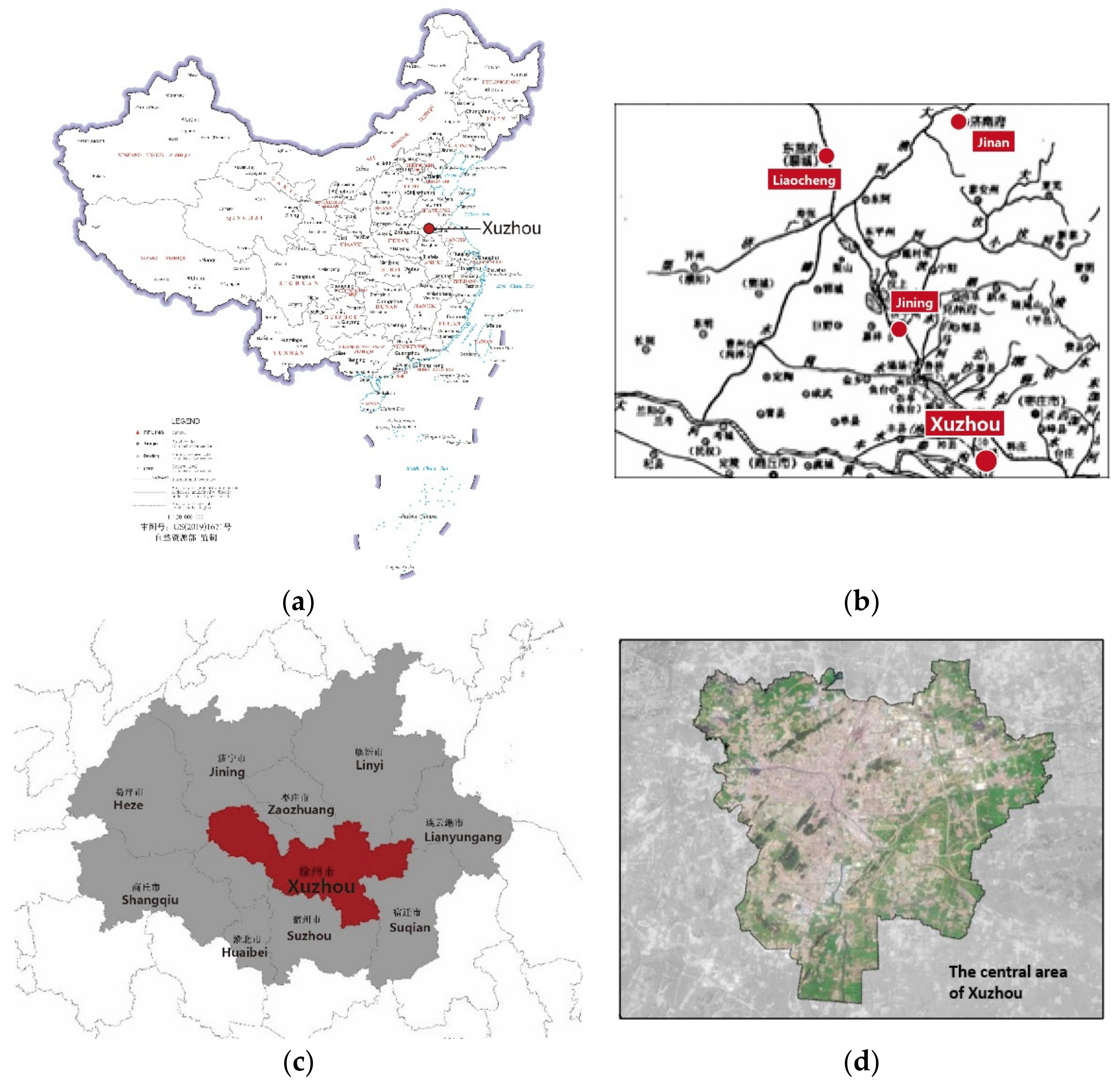
Xuzhou, located in Jiangsu Province in eastern China, has a superior landscape environment. In the past, people made the best use of the advantageous natural environment in the process of urban space construction, forming a basic pattern of symbiosis between city and landscapes. Affected by natural disasters, wars, and other factors, Xuzhou was rebuilt several times after urban destruction. Consequently, the historical environment has not been continuously inherited. At present, most of the built space in the city was formed in modern and contemporary times [
9]. Even so, as is revealed by the comparison of the current urban space and the historical records, there exists some commonality, which is especially reflected in the relationship between the city and its natural environment. In the past, the thought of “the Harmony of Man and Nature” guided the construction of Xuzhou; now, great attention has been paid to ecological construction, which shares potential continuity with the historical understanding of city construction.
With the city of Xuzhou as an example, this paper studies the influence of the thought of “the Harmony of Man and Nature” on the formation of urban historical environment structure. Through historical document and map review, field investigation, and spatial analysis, the paper reveals the form and characteristics of the implicit historical environment structure formed in the interaction between urban construction and natural environment. On this basis, it explores the possibility of its guiding urban renewal today.
2. Literature Review
The local literature of Xuzhou is the basis of this study. The historical materials used in this study mainly include the local annals of Xuzhou in different times that can be found at present. These annals provide not only textual information about the city, but also city maps of different scales and perspectives. Many scholars have studied the urban historical environment of Xuzhou. Rao Xuegang (2019) found that Su Dongpo, a famous scholar in the Song Dynasty, advocated the thought of “Unity of Heaven and Man” when he was the governor of Xuzhou. This reflects that people at that time paid great attention to the protection of ecological environment and coordinated development with the city when constructing the city [
10]. Dai Peichao (2014) revealed the close correlation between water environment and the rise and fall of Xuzhou. Based on his research, he claimed that Yi–Shu–Si river system, the old course of Yellow River, and the Grand Canal system played an important role in Xuzhou’s urban development and corresponding changes [
11]. Xie Kaijun (2019) put forward that in view of the particularity of Xuzhou’s historical changes, underground historical space resources were of great value. He strongly advocated for the idea of co-existence between ground and underground being adopted to advance contemporary urban historical space protection [
12]. Zhang Rong (2001) observed that Xuzhou’s historical environment had the cultural essence of the Western Han Dynasty, displaying the environmental characteristics of three-city overlapping and rich natural landscapes. On this basis, he put forward that ecological and environmental methods should be employed to rebuild Xuzhou’s urban environment and protect its historical and cultural heritage [
13].
There are many cities with a long history of city construction in China, and they have formed a distinctive urban historical environment. In a study of the historical environment of Chinese cities, Dai Jian (2003) held that cities should be regarded as a way of existence. He also maintained that the characteristics of traditional cities should be grasped from the perspective of integration, structure, and modeling. According to his study, exploring the way in which cities exist in their natural environment is one important issue [
14]. From the perspective of time, Dong Wei (2021) revealed that during the formation of historical urban environment in China, urban construction and abandonment developed in succession with historical changes, forming a very obvious overlapping and juxtaposition phenomenon [
15]. From the perspective of space, Fan Tingting and Guo Huayu (2020) discovered that single buildings had multiple and ignorable connections with their historical environment. Only in the process of revealing the interactive relationship between the two can we understand the deep meaning of constructing urban landscapes with Chinese charm [
16]. When exploring the protection and renewal of the historical environment of Chinese cities, Zhang Fan and Lu Jiwei (2009) held that the concept of conservation evolved from static protection to urban heritage reuse and then to urban culture re-creation [
17]. Wang Lijun and Shu Ping (2010) maintained that the process of conservation and regeneration required a methodological system of classification and grouping. Forms with similar structural characteristics could be classified, and specific cultural and traditional images restored and re-presented, so as to apply typology methods to historical environmental protection and regeneration [
18]. Zhang Song (2017) observed that the sustainable protection of urban historical environment should focus on its social value and the maintenance of historical sites and collective memory related to the daily life of ordinary citizens [
19]. Wang Yang and Yu Li (2019) maintained that the historical attribute of urban environment is an important factor affecting man–land relationships. By responding to emotional meaning, the conservation of historic cities could undergo some beneficial changes. To be specific, public participation should be enhanced to realize the economic value of conservation and manage the landscape change in historic cities [
20].
There are also sufficient studies on this topic abroad. Rossi (1966) pointed out in his research the importance of collective memory for the creation of urban construction forms and rules. Through analogy, people could create cities and architectural works with their own history and memory [
21]. Bacon (1976) pointed out that the formation of urban appearance was the result of the interaction of many people in history and that parallel and comparable things in the historical process would benefit contemporary urban renewal greatly. He also mentioned that in the past formation of urban space, the design structure often decided the three-dimensional organization system formed by the interweaving of the final elements [
22]. Kostof (1991) revealed the order and significance contained in urban patterns from dominant images, such as organic form, grid diagram, form, magnificent style, and skyline [
23]. Celikyay (2010) pointed out that the historical environment, as an open-space museum of its own, exhibited and reflected the cultural identity of the city; in order to integrate these areas with the rest of the city as a whole, it is necessary to revitalize and recreate the historical environment [
24]. Kim (2002) et al. put forward that contemporary people should experience the scattered cultural heritage in the city through space design. According to their study, modern people can read and feel specific times in history by telling stories in the historical and cultural environment. In this sense, the identity and historicity of the city can be restored when cultural heritage is protected and restored [
25]. Fezzai (2015) pointed out that science and technology accompanied with the concept of sustainability have changed the way people interpret urban heritage and urban form, as well as the configuration of the urban and built environment [
26].
By studying the transformation process of the urban structure, Perinaud (2015) explored the changes in cities and effectively grasped the various states of the historical urban landscape and related transformation process [
27]. Couper (2018) maintained that the dual relationship between nature and culture in urban space was a kind of cultural construction. It is this relationship that creates the cultural conditions of urban space [
28]. Li et al. (2020) put forward that understanding the concept of historical place is crucial to urban design and place-building and that the quality of urban design, walking ability, and spatial effect are crucial to the renewal of urban historical space [
29].
As for recent research, the integration of natural heritage within the city has attracted more and more attention. Bartorila and Loredo-Cansino (2021) identified the necessary integration of natural heritage from the review of archival documentation, cartography, and planning tools [
30]. Zagroba M (2021) claimed that the characteristics of urban spatial structure were formed in the evolution of culture and natural environment [
31]. Lalomy K et al. (2021) pointed out that urban space that integrates natural and cultural elements together was more appealing [
32].
4. The Formation of Urban Historical Environment
4.1. The Historical Evolution of Urban Space
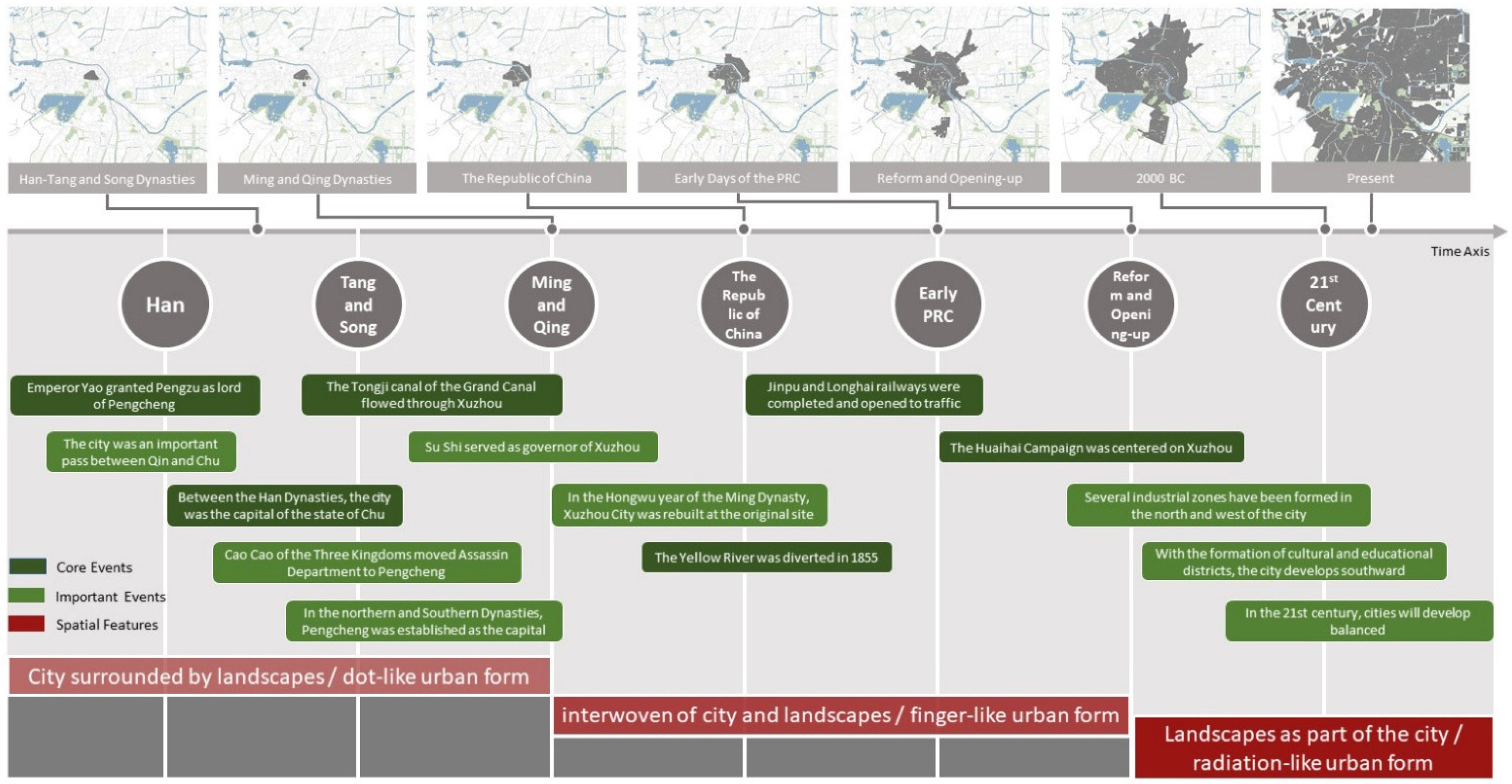
At present, the available historical documents on Xuzhou are mainly focused on the Ming dynasty and Qing Dynasty. According to archaeological research, Xuzhou’s ancient city, the ruins of which are preserved up to today, was rebuilt during the Reign of Jiaqing in the Qing Dynasty on the foundation of Xuzhou built in the Ming Dynasty. Before the Ming Dynasty, there were still many ground space sites of Tang and Song Dynasties and underground space sites of Han Dynasty in the central area of Xuzhou. As is shown in historical records, the historical sites of Tang and Song dynasties are highly related to the concepts and methods of city construction during and before the Han Dynasty. This reveals the historical continuity of urban space construction [
39]. Therefore, the characteristics of Xuzhou’s urban form in the longer period can be roughly deduced according to the urban form of Xuzhou’s ancient city in the Qing Dynasty.
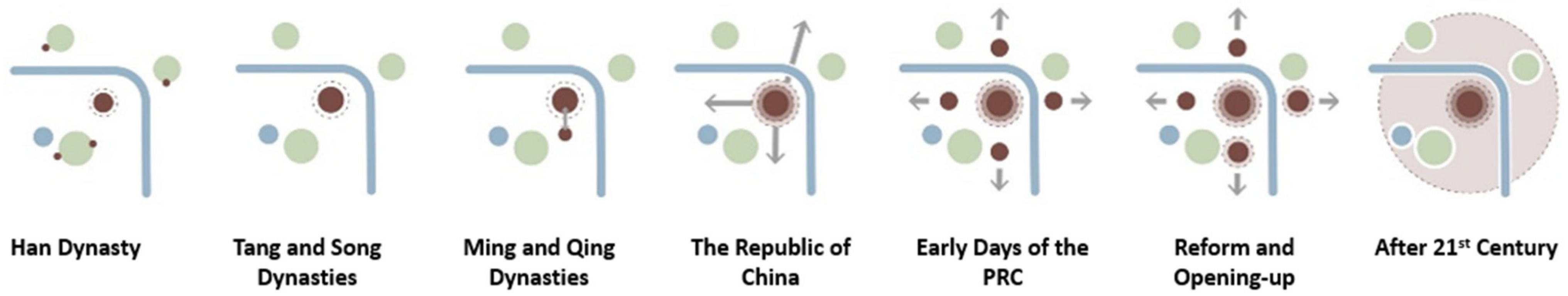
Through graphic analysis of urban space in different periods, it was found that the spatial evolution can be divided into three typical stages according to the relationship between the city and the surrounding natural landscape. The three stages are as follows: Stage I, in which the city is surrounded by landscapes; Stage II, in which the city and landscapes are interwoven; Stage III, in which the landscapes are part of city. Correspondingly, the urban form also presents three characteristics, namely, dot-like development, finger-like development, and radiation-like development (
Figure 4 and
Figure 5). The evolution process of specific urban spatial form is summarized as follows.
Stage I: The city is surrounded by landscapes, and the urban form is dot-like (before the mid-19th century). In a fairly long period, the urban area of Xuzhou remained unchanged in terms of city site and construction scope; meanwhile, due to the limitations of natural terrain, the city developed in a dot-like way. Xuzhou is the oldest city in Jiangsu Province, and the Han Dynasty was the heyday of Xuzhou’s urban construction. During the Han Dynasty, Xuzhou, as the capital of the State of Chu, was constructed as the capital of the whole country in terms of construction scale and diversity. This laid the foundation for the urban space of successive dynasties. A large number of underground relics of the tombs of kings in the Han Dynasty have been preserved to today. During the Tang and Song dynasties, the Grand Canal passed through Xuzhou, making Xuzhou an important hub city connecting the north and south. However, due to frequent floods, Xuzhou was rebuilt on the original site many times in the past [
36]. The consistency of site selection and city layout in successive dynasties shows that local people generally recognized the urban construction method and the life style supported by it; meanwhile, they also developed a deep understanding of the characteristics of natural environment.
Stage II: The city and landscapes are interwoven, and the urban form is finger-like (from the mid-19th century to the 1980s). During the period from the Republic of China to China’s reform and opening up, the urban built-up area crossed the Yellow River and expanded outward in a finger-like way. Due to silt in the estuary, the Yellow River was diverted in 1855, and the Xuzhou section was abandoned. Since then, the function of grain transport through the Grand Canal gradually declined in Xuzhou. In the 1960s, Longhai railway and Jinghu railway converged in Xuzhou, and railway traffic became one of the important factors affecting urban development. In this case, the urban area gradually grew outward along the main rail lines. Meanwhile, due to the limitation of natural terrain, the urban area and landscape elements were interwoven with each other [
40].
Stage III: Landscapes are part of the city, and the urban form tends to be radiation-like (from the 1980s to present). After China’s reform and opening up, Xuzhou ushered in a stage of rapid development. The urban area expanded and grew rapidly in multiple directions. On the one hand, several industrial zones were formed in the north and west of the city. On the other hand, with the formation of the southern cultural and educational areas, the city displays a southward development trend. Since entering the 21st century, a new urban area has been formed in the east of the city. The urban space developed in a balanced way to the peripheral area: the landscape elements originally in the periphery were gradually engulfed and transformed into the landscapes inside the city.
4.2. Characteristics of Historical Environment Evolution
It can be seen from the urban form of Xuzhou in several periods that the relationship between the city and the natural environment was one of the primary factors to be considered by the ancients when they built the city. Initially, people paid great attention to the location of the city in the natural environment, which was manifested as “a city lying in the embrace of mountains and rivers”. In the later period, when the city continued to expand outward, this consideration was represented by more transformation and utilization of natural resources, that is, transforming the natural resources into “landscapes in the city”. Therefore, the role of landscape elements in the urban pattern has largely shaped the characteristics of Xuzhou’s historical environment. To be specific, the characteristics are as follows:
- (1)
The nature–city relationship has been highly close from the very beginning of city construction. Since the volume of landscape elements in Xuzhou area is relatively small, it is comparable with the urban scale to some extent and thus can be basically integrated into the construction of urban environment. Historically, site selection and city construction have maintained the spatial pattern of “city surrounded by mountains and water”. This not only conforms to the feng-shui of traditional Chinese urban construction but also provides safe terrain and sufficient living resources for cities through the combination of natural elements.
- (2)
The nature–city relationship changes with the growth of the city. Affected by the distribution pattern of landscape elements and traffic routes, the city sprawls outward firstly in a finger-like manner; when the urban area extends to such a degree as to engulf small landscapes, the city and landscapes present a continuous state. Along with the change of city–landscape relationship, there are many space construction marks of different periods and types left behind, forming the historical overlapping space of outward expansion.
- (3)
Natural landscape and urban culture coexist. With the development of urban life, Xuzhou formed its local landscape culture with its own characteristics. For example, many urban stories that have been passed down for generations were created around landscape elements, among which the legends of Yunlong Lake, Yunlong Mountain, and the abandoned Yellow River are the most popular. In history, the residences and halls of famous literati were also built in or on the small landscapes in the city. Meanwhile, landscape is also an important theme for ancient poetry, painting, and calligraphy.
In all, the thought of “Harmony of Man and Nature” has permeated all aspects of the evolution of Xuzhou’s historical environment. In order to deeply understand the characteristics of Xuzhou’s historical environment, the interaction between human and nature should be investigated thoroughly. At the same time, contemporary urban environment construction should also highlight the local historical and cultural characteristics of Xuzhou on an “ecological” basis, so as to conform to the internal logic of urban growth.
5. Analysis and Discussion of Historical Environment Structure
According to the preliminary study on the historical development of Xuzhou urban space, three main spatial aspects of the historical environment can be determined: the relationship between the city and the natural landscape environment, underground space, and age-old historical buildings. The inner spatial relationship of the three aspects has shaped the spatial structure of Xuzhou historical environment. This paper carries out a detailed analysis of Xuzhou’s historical environment based on these three aspects.
5.1. Analysis of the Spatial Structure of Landscapes
5.1.1. The Urban Landscape Environment in History
Most of the mountains and rivers around Xuzhou are small. The relationship between the city and the natural environment has been very close throughout history. At the macroscopic scale, superior geographical location and natural environment provide sufficient advantages for urban construction. As is stated in the annals of Xuzhou Prefecture during the Reign of Qianlong of the Qing Dynasty, Xuzhou was surrounded by rolling mountains. The convenient waterways such as the Bian river and Si river connected the Yangtze river and Huai river to the south, Shandong Province in the north, and Henan Province in the west. From ancient times, Xuzhou has been geologically crucial. This also proves the tremendous advantages of Xuzhou in terms of geology and environment. From the map of the waterway system that was collected in the annals of Xuzhou Prefecture during the Reign of Qianlong of the Qing Dynasty, it can be seen that the Yellow river once flew through the territory of Xuzhou. Compared with other counties and towns near the Yellow River (Suqian City, Suining county, Xiao county), Xuzhou is closer to the river. In this sense, with abundant landscape elements such as rivers and mountains, Xuzhou has a close relationship with natural resources on the whole (
Figure 6).
“Map,” in the context of this paper, refers to the ancient Chinese style of city map in particular. Most of the spatial information and elements expressed in it are highly abstract and generalized, showing the urban space image in people’s cognition at that time. According to the city maps of Xuzhou in different historical periods, the inner and outer space of Xuzhou display the following characteristics (
Figure 7): the relative position of the surrounding mountains is basically correct, and there are accurate names marked; set as the focal point, the element of water is portrayed in an exaggerated style; the urban layout basically conforms to the axisymmetric shape of the capital, but the north side of the outer contour is abstracted as a semi-arc, indicating the adjustment of the urban form to the natural terrain.
Thus, it can be concluded that people of all periods would follow the basic rule of building urban space—to deeply grasp the characteristics of natural environment patterns and adapt to natural terrain conditions.
5.1.2. The Spatial Structure of Mountains
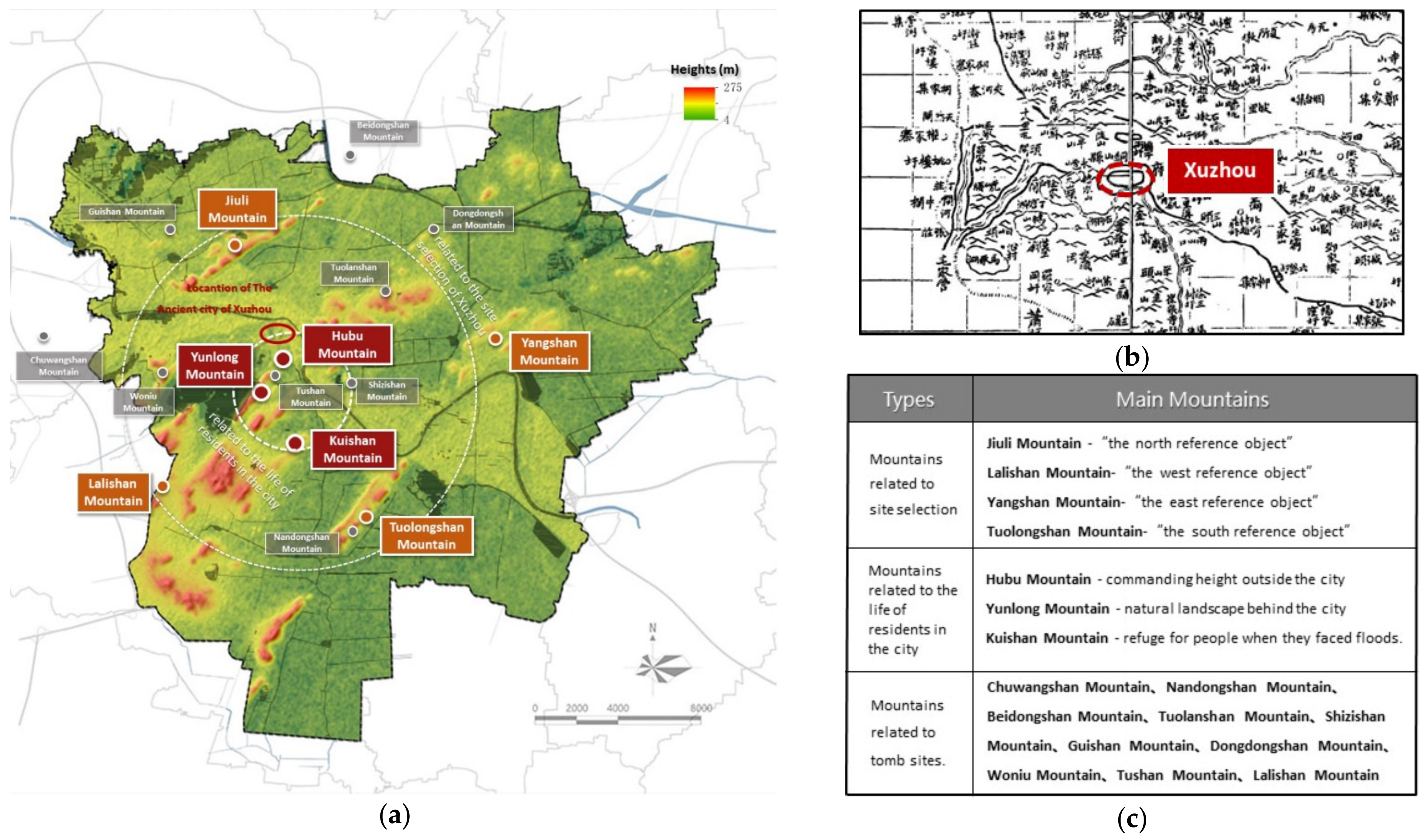
Xuzhou is located in the alluvial plain of Huaibei, surrounded by more than 80 hills. The GIS topographic map accurately shows that there are still a large number of small mountains in the urban area of Xuzhou. According to the spatial relationship between city and mountains, it can be seen that the spatial structure of mountains can be divided into two circles: inner and outer circle (
Figure 8).
Different mountains play different roles in the process of urban growth. (1) The outer circle of mountains, including Jiuli Mountain, Lalishan Mountian, Tuolongshan Mountain, and Yangshan Mountain, are related to the site selection of Xuzhou. In accordance with the traditional Chinese geomantic omen, the four mountains form an ideal city site for Xuzhou, with Jiuli backing Xuzhou up in the north, Tuolongshan in the south, Lalishan in the west, and Yangshan in the east. These four mountains served as the boundary markers of urban development for a long time. (2) The inner circle of mountains, including Hubu Mountain, Yunlong Mountain, and Kuishan Mountian, are related to the life of residents in the city and thus highly functional. Hubu Mountain is the nearest commanding height outside the ancient city of Xuzhou, thus serving as the military base to monitor Xuzhou; Yunlong Mountain is the natural landscape behind the city, providing a place for residents to have a rest and play; Kuishan could offer refuge for ancient people when they faced floods. (3) A dozen small hills in the outskirt of Xuzhou, with Guishan Mountain as a representative, are related to tomb sites. In the past, many emperors’ graveyards were built along the hills, and they are preserved to this day.
5.1.3. Spatial Structure of Water Systems
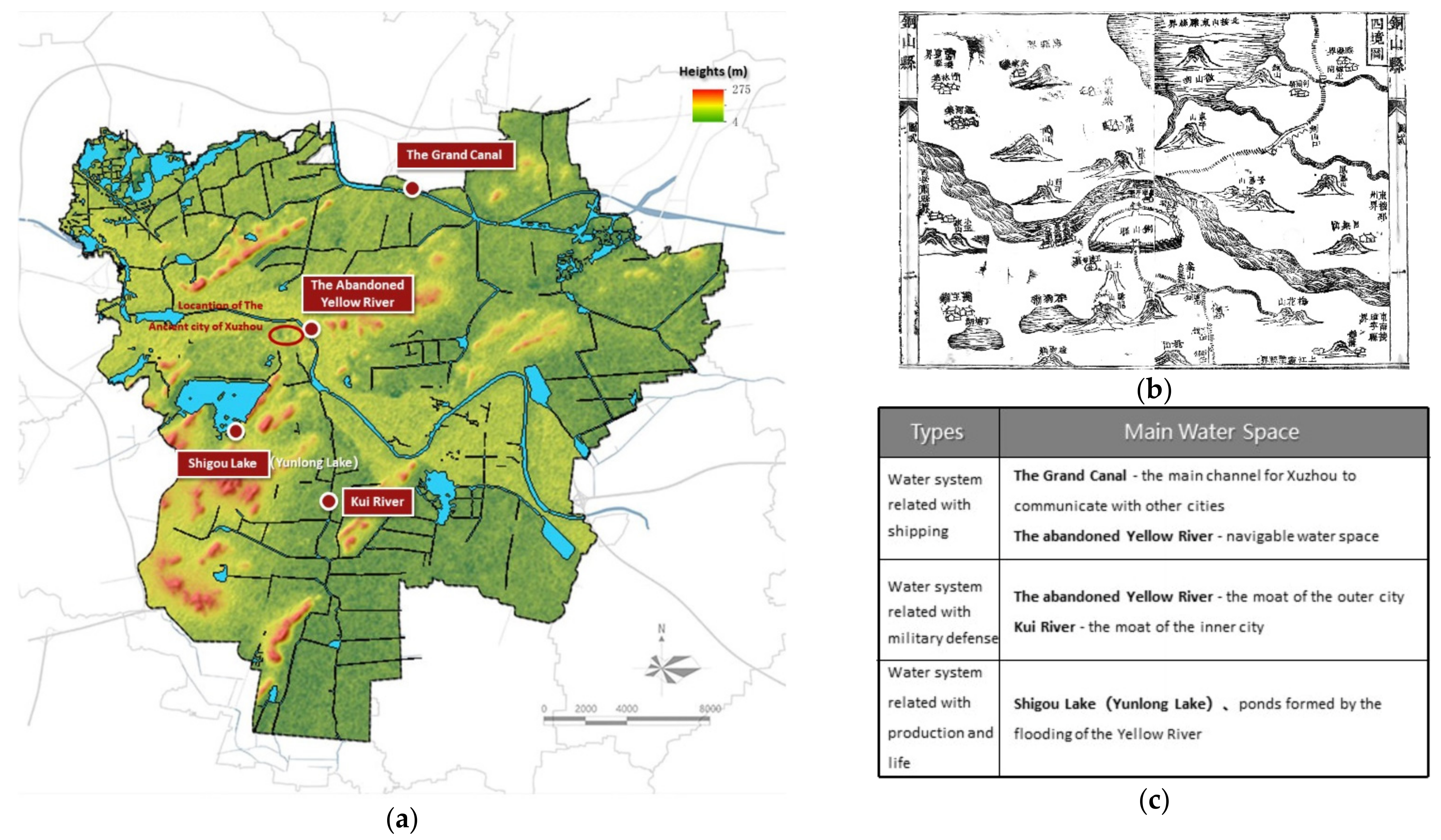
The water transportation of grain via the Grand Canal has become an important factor affecting Xuzhou’s social and economic development since the Tang and Song dynasties. There are two important water systems around Xuzhou. One is the Beijing–Hangzhou Grand Canal, which is about 7.5 km to the north of the city. Although it does not flow directly through Xuzhou, it fosters shipping development. The other is the abandoned Yellow River, as the mother river of Xuzhou, which winds from the north to the southeast, forming an important geographical feature of Xuzhou’s ancient city—a city with river flowing around on three sides. The two important water systems and the lake in the city work together to forge a “Two-River-One-Lake” pattern. This pattern then becomes the main structural characteristic of water space in Xuzhou (
Figure 9).
In accordance with the role that water system plays in urban development, the water space in Xuzhou can be divided into three types: (1) Water system related to shipping, mainly including the Grand Canal, and the abandoned Yellow River. During the Ming Dynasty, the Beijing–Hangzhou Grand Canal started from Beijing in the north and ended in Hangzhou in the south. It connected the five major water systems, namely the Haihe River, the Yellow River, the Huaihe River, the Yangtze River, and the Qiantang River. It became the main channel for Xuzhou to communicate with other cities. In addition, the abandoned Yellow River adjacent to the urban area was also navigable. (2) Water system related to military defense, including Kui River and the abandoned Yellow River. These two rivers used to serve as the moat of the inner and outer city for the purpose of military defense. (3) Water system related to production and life, mainly including Shigou Lake, the predecessor of Yunlong Lake in the current downtown area, and several ponds formed by the flooding of the Yellow River. These water bodies provide water for production and life for the residents on the one hand and have a certain drainage effect on the other [
41].
5.2. Analysis of Underground Spatial Structure
5.2.1. The “City-Beneath-City” Spatial Structure
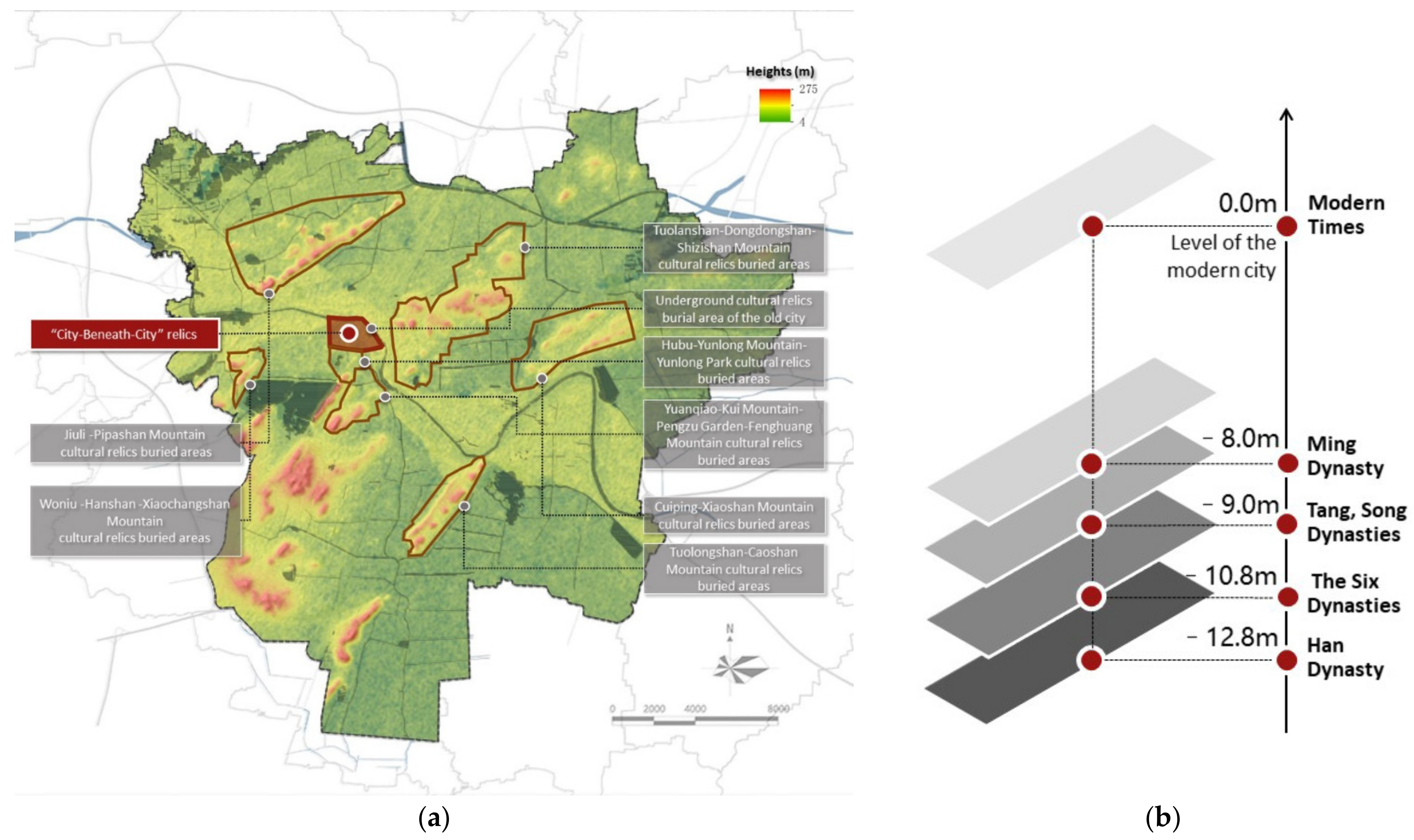
The particularity of Xuzhou’s historical environment changes leads to two types of underground historical environment space: “City-Beneath-City” relics and “Han tombs”. The former originate from the periodic urban environment changes. As is shown in historical records, the abandoned Yellow River in the north of the city flooded the city many times. After the city was destroyed, people kept rebuilding the city on the original site, forming the phenomenon of underground space stratification. In the long run, this rebuilding shaped the historical landscape of Xuzhou—city beneath city and street beneath street.
At present, archaeological research has proved that there are many underground historical space layers and areas with buried cultural relics in the urban area. As is revealed, the underground culture layer of Xuzhou can reach a depth of 12.8 m underground. The continuous underground façade can be traced back from modern times to Ming, Song, and Tang Dynasties, the Six Dynasties, the Eastern Han Dynasty, and finally to the Western Han Dynasty. This geological and historical phenomenon has been excavated and partially displayed in the Gupeng Square section, Huilongwo section, Kuaizaiting section, and Central section of the abandoned Yellow River in today’s Xuzhou. The city section left by the overlapping of multiple periods completely presents the historical growth ring of Xuzhou, which is basically the same as the current location of the modern city center. This demonstrates the overlapping of the historical center and the modern center (
Figure 10).
5.2.2. The Spatial Structure of Han Tombs
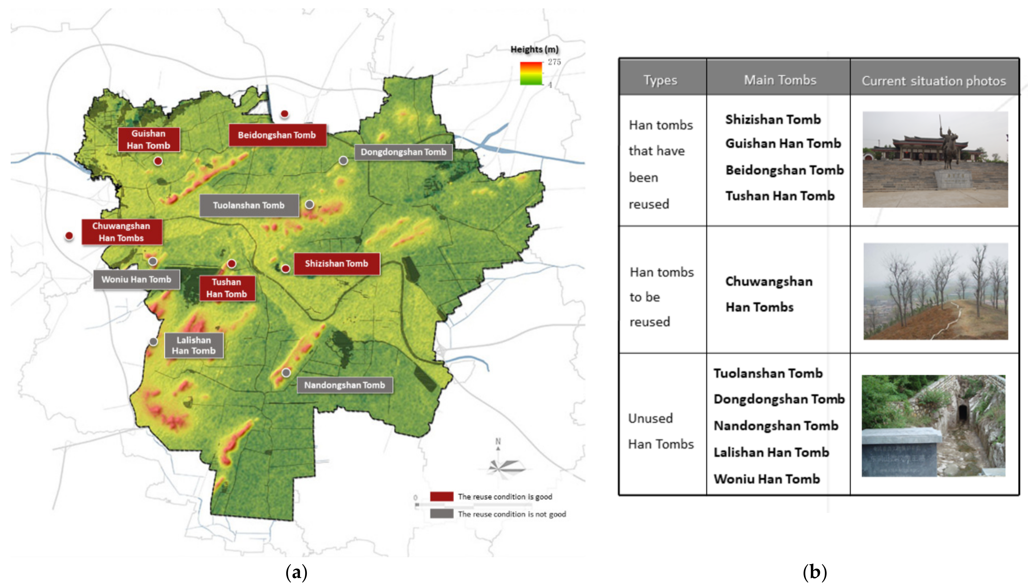
Han tomb groups are another typical category of Xuzhou underground resources. The political status of Xuzhou was relatively high in the Han Dynasty, thus constituting the heyday in the history of Xuzhou city construction. The Han culture bred in the same period became the most representative part of Xuzhou local culture and the cultural calling card of Xuzhou. The Han tombs are mainly distributed outside the city, especially in the mountains in the west and north sides. In total, eight Han tomb groups have been discovered, with a total of 15 tombs. In addition, there are eight tombs that can be definitely confirmed as the tombs of dukes and kings in the Western Han Dynasty or the tombs of the Liu family (the royal family of Han Dynasty); another ten tombs have been confirmed to be at the duke level. These Han tombs reflect the thoughts of ancient Chinese people—taking nature as the origin and destiny of life and returning to nature after death [
35]. In terms of structural form, the Han tombs are distributed around the main urban area of Xuzhou. As a whole, the Han tombs have two notable features: their great number and their harmonious integration with the surrounding natural landscapes (
Figure 11). With this inseparable relationship with natural environment, the underground heritage may contribute to building the ground-level distinctive urban public space [
42].
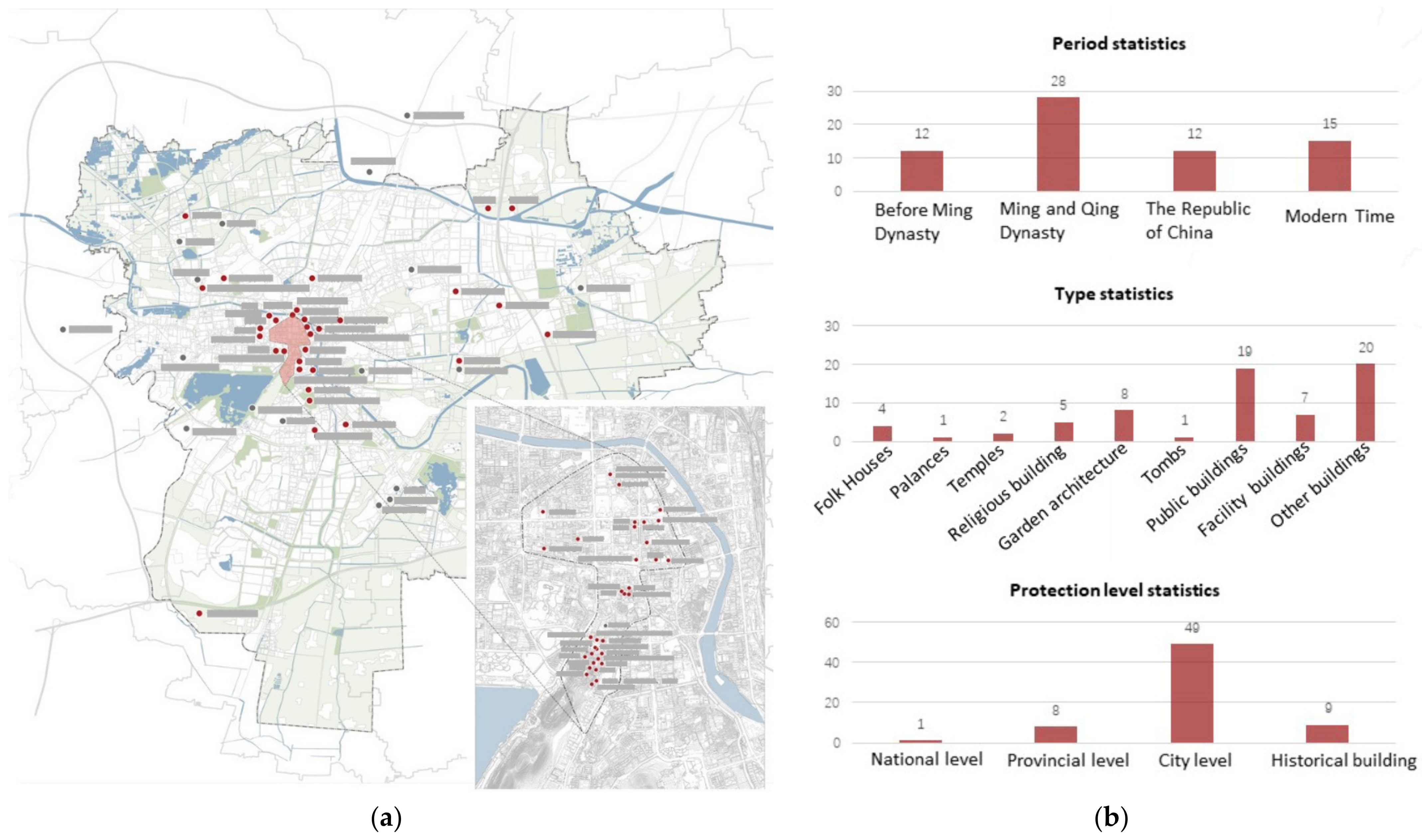
5.3. Analysis of Building Distribution Structure
At present, Xuzhou’s urban space has displayed significant historical overlapping. This can be reflected by fragmented buildings and small historical areas that are scattered in the modern urban space. In the central urban area, there are in total 67 important historical buildings and constructions. These buildings and constructions were built in different historical periods, such as the Song, Ming, and Qing dynasties and the Republic of China. Among them, the ancient architectural remains are mainly distributed around natural landscape resources such as the abandoned Yellow River, Yunlong Mountain, and Hubu Mountain; the comparatively modern architectural remains are mainly distributed in the old city; and the rest are scattered in Jingshan Bridge area and Jiuli district in the north and Zhaishan district in the south (
Figure 12).
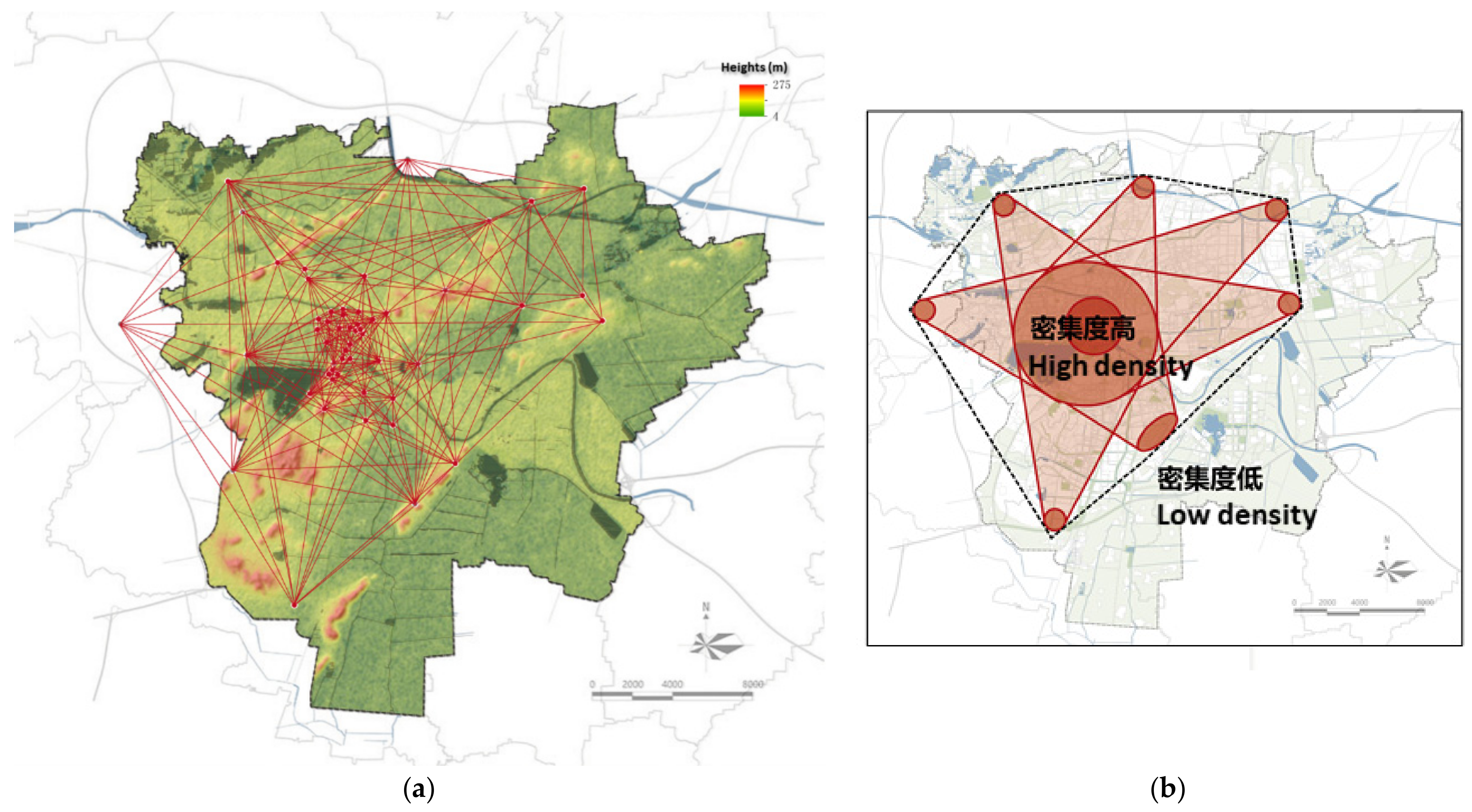
In order to further analyze the structural form of age-old historical buildings, building resource points were selected to connect the buildings in pairs, all points were connected to form a network without repetition, and then envelope analysis was conducted. When the historical resource points were connected, the outer contour line could be formed, which in turn could delineate the key association area of historical resource points. The density of the envelope lines could be an indicator of association degree. To be specific, the denser the envelope lines are, the higher the association degree is, and vice versa.
As is shown by the envelope analysis of the building resource points in the central urban area of Xuzhou, the intensity of resource points gradually decreases from the old city to the outside. To be specific, the intensity displays a three-level decline: the high intensity level mainly covers the old city, the abandoned Yellow River, and Yunlong mountain; the moderate intensity level is mainly distributed around Yunlong Lake, Kuishan Mountain, and Shizishan Mountain. The envelope range is highly overlapped by the central urban area, indicating that the historical resource points are densely distributed in the central urban area. The distribution characteristics of resource points are consistent with the landscape pattern (most of the envelope range overlaps with the red and yellow zones of the GIS topographic map). This further proves the correlation between the distribution of historical buildings and the landscape pattern (
Figure 13).
5.4. Discussion on the Characteristics of Historical Environment Structure
The structural characteristics of Xuzhou’s historical environment can be abstracted by interpreting the spatial types of its current historical environment and the corresponding correlations. Among them, landscape space is a relatively stable space type in the historical development and evolution of Xuzhou, assuming the role of the “skeleton” of historical environment construction. It is reflected in the following two aspects.
- (1)
Landscape environment itself, as the base of urban environment, constructs the basic framework of material space pattern through terrain and natural elements. To be specific, the inner and outer circle of mountains and the “two-rivers-and-one-lake” pattern constitute the spatial framework of Xuzhou. Under this spatial framework, the mountains and rivers surrounding Xuzhou set up the natural environment limitation upon the urban space, serving as a relatively stable spatial element in the evolution of urban form.
- (2)
The valuable experience of building and rebuilding the city in a given landscape environment repeatedly has been passed down to the modern times, which can serve as a thinking “framework” for urban planning and construction. This framework, to be specific, is to use mountains as safe shield and protection, to use water systems to develop grain transportation, and to create living space between mountains and rivers. As a guideline for urban development and management, this framework gradually evolves into the urban construction concept—to respect the mountains and rivers, to adjust to the local conditions, and to pursue the harmony of man and nature.
The other two elements of historical environment—underground space and architectural space—also derive unique spatial structures under the overall spatial framework of Xuzhou. They enrich the details of Xuzhou’s historical environment. Correspondingly, the spatial structures deriving from underground space and architectural space are as follows.
- (1)
The underground space of Xuzhou, as the product of special historical periods, is the material origin or source of the local history and culture—the Chu and Han culture. The “inner-core-outer-ring” spatial structure coincides with the correlation between central urban area and the outer circle of mountains, and it also reflects the ancient people’s mastery and utilization of large-scale environmental characteristics.
- (2)
The historical buildings and constructions scattered in the urban area are a kind of witness to the different periods of Xuzhou’s growth and evolution. In some sense, they are the marks that history has left in Xuzhou. The distribution of historical buildings displays a decline in density from the urban center to the outer city, reflecting the diversified life patterns of people in different historical periods.
Natural landscapes, underground space, and age-old historical buildings constitute the historical environment of Xuzhou. To sum up, the structure of Xuzhou’s historical environment consists of skeleton (the natural landscapes), origin (underground space), and marks (historical buildings) (
Figure 14).
5.5. Management and Utilization of Historical Environment Resources
Historical environment is the congruent occurrence of time processes at the spatial level in urban growth. As the wealth of cities, historical environment exerts a complex influence on urban space. It can be manifested in the multiplicity and overlapping of relevant elements and the deep structural relations formed by the interweaving of elements. This influence is not only intangible but also profound on urban space. Attaching importance to the conservation and integration of historical environment in modern urban construction is indispensable to the protection of the urban history and culture; meanwhile, it is also a beneficial method of shaping the characteristics of the contemporary urban environment [
43]. The implicit structure of historical environment is an integral part of urban historical environment resources, and its role in guiding current urban renewal can be manifested in the following aspects:
- (1)
The main purpose of the implicit structure of historical environment is to support the harmonious relationship between human beings and nature in the city. Accordingly, the planning and design methods and experience embodied in the structure can be used for reference to guide the direction and form control of ecological city construction at the macro level today. Among the different types of historical environment space, natural landscapes not only work as the skeleton of the whole historical environment but also serve as the basis for the development of urban space today [
44]. Therefore, natural landscapes are a highly suitable structural element to link the historical and contemporary urban space. It is of great significance for the sustainable construction of urban environment to understand the natural space in the city from the historical perspective, and it is equally important to protect the relationship between human beings and natural environment through pattern repair, structure reinforcement, and network organization [
45].
- (2)
For cities whose historical environment has been fragmented, the currently popular practice is to protect the scattered historical relics and develop them into independent scenic spots. However, the implicit structure of historical environment provides us with a logical idea to connect the scattered historical relics into a whole and rebuild the relationship with surroundings [
46]. For instance, the underground space of Xuzhou represents the historical and cultural characteristics of this city. It can be protected, developed, and managed systematically according to its implicit structure of “inner core and outer ring” so as to establish a large-scale characteristic historical landscape.
- (3)
The implicit structure of historical environment allows us to better understand the position and function of a single historical resource point in the whole city’s historical culture and spatial form. This has significance for the hierarchical protection of historical buildings, the integration of historical relics and modern city construction, and the consideration of multi-cultural display in the city.
6. Conclusions
This paper systematically studies the formation and evolution process of Xuzhou’s urban historical environment and its internal historical environment structure. The conclusion is drawn that natural landscapes are the “skeleton,” underground space is the “origin”, and historical buildings are the “mark” of historical environment. The “skeleton” function that natural landscapes play is the foundation and core characteristic of historical environment; underground space and historical buildings confirm the longitudinal historical process of the city and reflect the spatial imprint of different historical periods, respectively. The three work jointly to form the overall structural characteristics of Xuzhou’s implicit historical environment and construct the basic framework of people’s living form in the city. It can be one of the reference frames guiding today’s urban renewal.
For the cities whose historical environment has been destroyed in the process of modern construction, the implicit structure can provide some reference for the protection of urban history and culture and the renewal of stock space. The implicit structure can offer some guideline for urban renewal in such aspects as form control, resource integration, and multi-cultural display. In this sense, it is beneficial for achieving the balance between and fusion of modern construction and historical inheritance in the process of urban renewal. The core of multi-dimensional utilization of historical environment resources in contemporary urban construction is to protect the implicit structure of historical environment as much as possible. On this basis, the relationship between man and nature can be further developed in the continuous evolution of urban space. This paper can provide reference for the inheritance and renewal of historical environmental protection in other cities with similar conditions.

