1. Introduction
Cities and their regions could be considered as urban ecosystems with a high population density [
1,
2], despite their dependency on other components of the ecosphere [
2]. Responsible at present for a large part of the energy consumption [globally 75%] and greenhouse gas emissions [70% of GHG emissions worldwide are from cities, according to the UN, 2000], cities are also leaders in climate innovation and the place where citizens engage in climate action [
3,
4,
5]. Today obsolete, yet historically relevant, the urban-rural dichotomy, used to be in tune with separate policies for city and countryside [
6]. Around the turn of the century, the urban-rural relationship has been taken into account by the European Commission [EC], and the policies which focus on the linkage between them, have been gradually prevailing [
6,
7]. As part of the current framework provided by the Green Deal, the Biodiversity Strategy, in the context of cities, concerns the systematic integration of Green Infrastructure [GI] and Nature-Based Solutions (NBS) into urban planning [
8]. Indeed, a key factor in promoting biodiversity, sustainability, and Ecosystem Services (ES) lies in the connectivity of GI [
9]. Therefore, urban planning can entail the enhancement of the connections among the existing green spaces throughout the city, affecting the distribution of Urban Green Infrastructure (UGI) and NBS within the urban tissue [
10,
11]. NBS, can be classified into 3 different types, referring to ecosystems which are preserved, creatively managed, or newly introduced [
12,
13].
Urban sprawl results in the loss of character of surrounding rural landscapes [
14], entails the urbanization of natural and agricultural environments, and the fragmentation of natural-urban habitat, and affects the respective Ecosystem Services [ES] provided [
9,
10]. The pressures and current deregulation of agricultural policy in several EU countries results in the development of various land uses in the place of agricultural lands in the urban periphery [
15], revealing the vulnerability of urban-rural fringes. Nevertheless, within the metropolitan context, urban and peri urban agricultural spaces have the potential of playing a strategic role not only in production, but also in the conservation of biodiversity, water regulation, and other ES provision, including climate change mitigation and rural character preservation [
1,
16,
17,
18].
The interconnection of fragmented rural areas with GI and UGI network strategies in the context of urban fringes, is a way of strengthening the link between city and its rural outskirts. Sebastien Marot perceives four directions or ‘models’ towards which the relation of urban and agricultural landscape can evolve. Among these four directions, ‘
Infiltration’ is described as an invasion of agricultural practices into the urban tissue, through the occupation of neglected, disused spaces and urban voids. Marot furthermore connects the model of
infiltration with Urban Agriculture [UA] [
19]. Along with the enhancement of connectivity of UGI networks, UA can be considered as a complementary tool for the confrontation of urban sprawl. Furthermore, UA could result in a series of benefits since its practice has been associated with the creation of healthier communities. Community-led UA practices encourage activism, contribute to social cohesion and inclusion, foster gender equality, and socialize newcomers into multicultural and pluri-ethnic frameworks [
20,
21], while promoting food security, social development, economic development, and environmental development [
22].
The present legislative framework lacks specific policies for food production in urban and peri-urban regions [
15]. More precisely, the main policy for Farming and Food Production in the EU known as the Common Agricultural Policy [CAP], up to 2017 did not match the specific needs of Urban and Peri-Urban Agriculture [UPUA] [
23]. The new CAP [2023–2027] has been announced as being in tune with the Green Deal, and as a key tool to attain the goals of the Farm to Fork (F2F) and Biodiversity Strategies (BS). Announced in 2020, F2F and the BS are pronounced as mutually effective [
24]. The Goals of the EU F2F strategy are the preservation and restoration of the land and freshwater resources on which the food system depends, the mitigation of climate change and adaptation to its impacts, the protection of land, soil, water, air, plant and animal health and welfare, and the reversing of the loss of biodiversity [
25]. An urban planning strategy which involves UPUA can attain most of the goals formulated in the Green Deal F2F and BS [
15]. Additionally, the implementation of UPUA within the urban-rural fringe, could be considered as a direction for innovative planning which includes and promotes traditional agricultural landscapes, and safeguards the traditionally rural soil. This type of intervention can be considered among the NBS [
12,
13]. To prevent health and environmental hazards, the reuse of surface and wastewater for UPUA practices should be posterior to its quality monitoring and proper treatment. [
26,
27,
28,
29].
Diachronic rural landscapes are perceived as bearers of cultural ES, related to the continuation of traditional agricultural practices [
30]. Furthermore, locally adapted traditional practices should be re-assessed in the light of NBS criteria, since they may contribute to the re-establishment of sustainable processes within the area they are relevant to [
12]. The strategies for harnessing cultural heritage in ways which render the cities and communities sustainable, is expressed in the way ICOMOS approaches one of the Sustainable Development Goals, SDG 11 “Make cities inclusive, safe, resilient and sustainable”. The urban fringe can be a field where cultural heritage meets SDGs, through the formation of a UGI network: which rehabilitates and regenerates disused buildings and spaces, by establishing their connection with public space and rural landscape, while using traditional typologies, local heritage technologies and materials [
31]. Additionally, as a result, negative social consequences of urban decay associated with disused spaces are confronted, by increasing the provision of cultural and other ES to the local community and the citizens in general [
32]. A revised European Green Deal [EGD] should assess the existing building stock and promote the retrofitting and refurbishment of energy-wasting buildings [
33].
Focusing on a case study in the Southern periphery of Milan, this research aims to:
Investigate the role that GI, UGI and NBS can play in redefining urban-rural fringe areas by creating a network which reverses the biodiversity loss according to the Green Deal Biodiversity Strategy
Define research-by-design strategies comprising the regeneration of agricultural heritage practices for making urban peripheries inclusive, resilient and sustainable [
8,
25].
Define guidelines for planning and design approaches in order to remediate landscape fragmentation and ES loss within the urban-rural fringe of European cities.
2. Materials and Methods
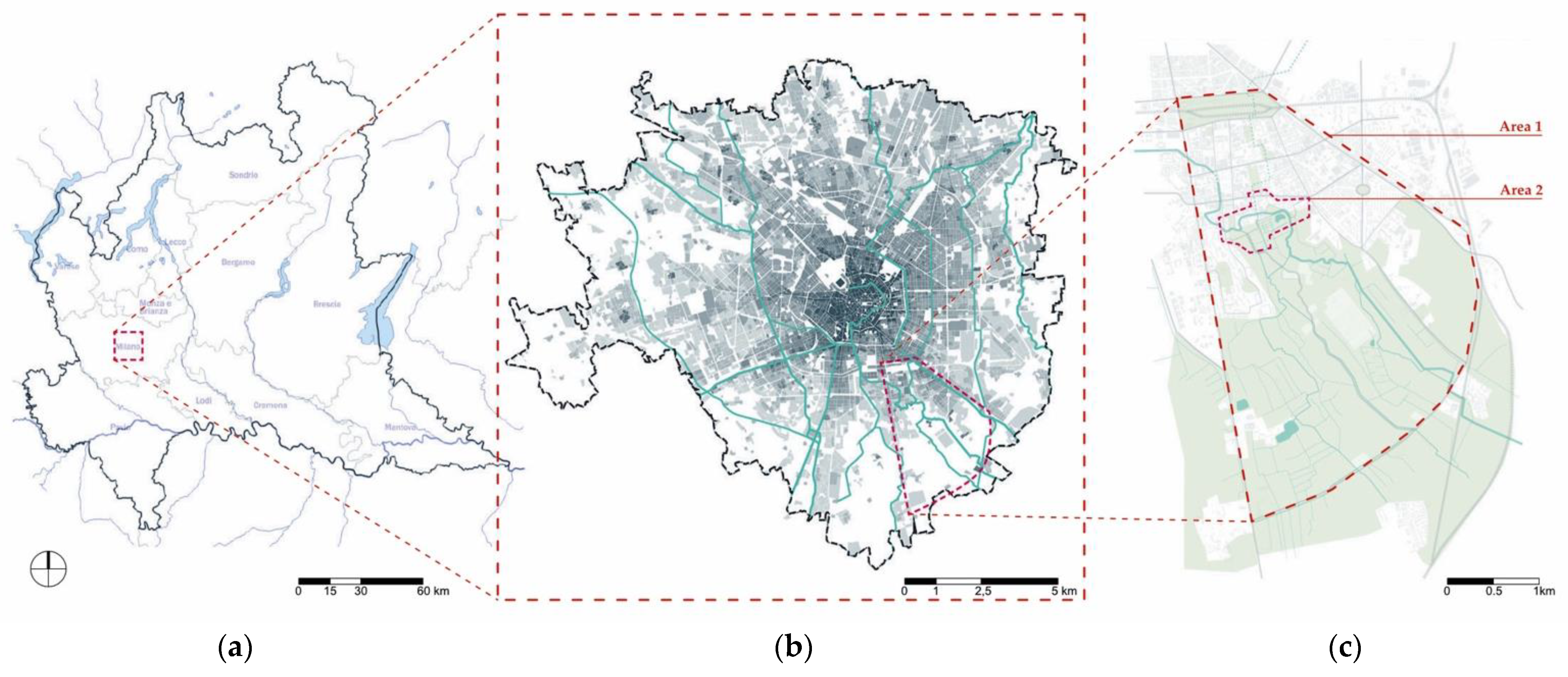
2.1. Study Area
The study area of this research is located in Italy, in the Lombardy region, within the municipality of Milan, in the South-East periphery of the metropolitan area (
Figure 1). The studied area, identified as area 1 (
Figure 1c) is broadly divided into two parts: the northern side which is considered urban tissue, and the southern side which is considered rural landscape. It also includes a smaller area (area 2) identified as the most strategic location to investigate a site-specific approach.
The urban area comprises a district of social housing blocks and a former industrial area—the expansion of which was connected to the construction of the railway track—and is now undergoing a process of deindustrialization and urban development. This process is resulting in a shift of land-use, from productive to residential and third sector, allowing not only space for creative clusters and cultural activities to settle in the site [
30] but also highlighting the vulnerability of the site, in relation to the quality of urban open spaces and the perception of local citizens [
34].
On the other side, the rural portion (which was formerly managed by religious orders and gradually conquered by the urban sprawl phenomenon) has lost its character of landscape structure and regulation. However, the institution of the rural protected green belt of Parco Agricolo Sud Milano in recent decades has prevented further urban expansion and has brought new attention to the importance of this green area for the local community. It encourages groups of citizens and local associations to take care of the site and it starts regeneration projects [
30,
35,
36]; it encourages agro-ecological practices, such as agro-forestry and urban agriculture, with the aim of reversing the loss of biodiversity and engaging the local community [
16,
17,
37].
Due to this constant process of change, especially during the post-industrial decades, both the urban and rural landscapes remain vulnerable to neglect and loss of identity. This is mostly demonstrated by the high number of abandoned spaces and construction sites that characterize the whole study area and make it discontinuous.
Another evidence of this tendency can be seen in the gradual loss of importance of landscape and architectural landmarks related to the agricultural environment. For example, the Vettabbia Canal. This canal used to be the backbone of the area for many centuries. It represented the core of economical and agricultural activities around the site. It therefore gave a structure and a hierarchy to the entire site landscape as well. The canal now seems confined to a secondary role, hidden between residential blocks and acting as a barrier instead of as a connecting element between urban tissue and rural landscape.
The same tendency can be observed for architectural elements, such as farmhouses and mills, formerly connected directly to the Vettabbia Canal, and to agricultural activities which are now abandoned or absorbed into the new urban tissue, and thereby losing their role as heritage symbols.
The area’s vulnerability derives as well from the fragmentation of the site, especially between urban and rural landscapes. This separation and lack of connectedness, both physical and visual, is one of the causes for the eclipse of traditional agricultural heritage practices. It represents an obstacle to the reappropriation of the site by the local community, which hinders the establishment of a resilient identity and increase the chances of the loss of ES and biodiversity [
7,
38].
2.2. In Situ and Archive Research Methodologies
The advantages of a continuous urban green system are linked with environmental and social goals. On the one hand, environmental goals comprise, amongst others: the revitalization of existing outdoors spaces, the improvement of connectivity and accessibility of existing green spaces, the creation of new green spaces, the improvement of microclimate, the increase in biodiversity and sustainable mobility, the increase in water-permeable surfaces, the increase in green spaces
On the other hand social goals include: increased sociability and neighborhood revitalization, improved health and well-being, improved accessibility for people with mobility issues, aesthetic-functional upgrade of the city, and the highlighting of the unique character and spirit of each area (“genius loci”), etc. [
11].
The objective of enhancing connectivity is an integral part of the creation of UGI networks. The interconnection of UGI elements, and their planning as components of a whole, make them integral parts of a GI system [
1].
The aim is to create an integrated Urban Green Infrastructure network within the urban fringe, without designing an entirely new structure. The methodology followed entails the mapping and enhancement of the connectivity of already existing green clusters [
9]. Therefore, a methodology that includes site visits was chosen as the basis for the planning of UGI systems.
The understandings obtained by the site visits were complemented by a socio-cultural analysis of the area studied, through both synchronic and diachronic surveys. In respect of the above, the point of view engaged in this research towards the rural landscape of the urban fringe has been informed by the ES theoretical discourse. The ES classification was used in a comparative study between previous historical periods of the site, compared to the current situation, as a way of evaluating the proposed strategies [
30].
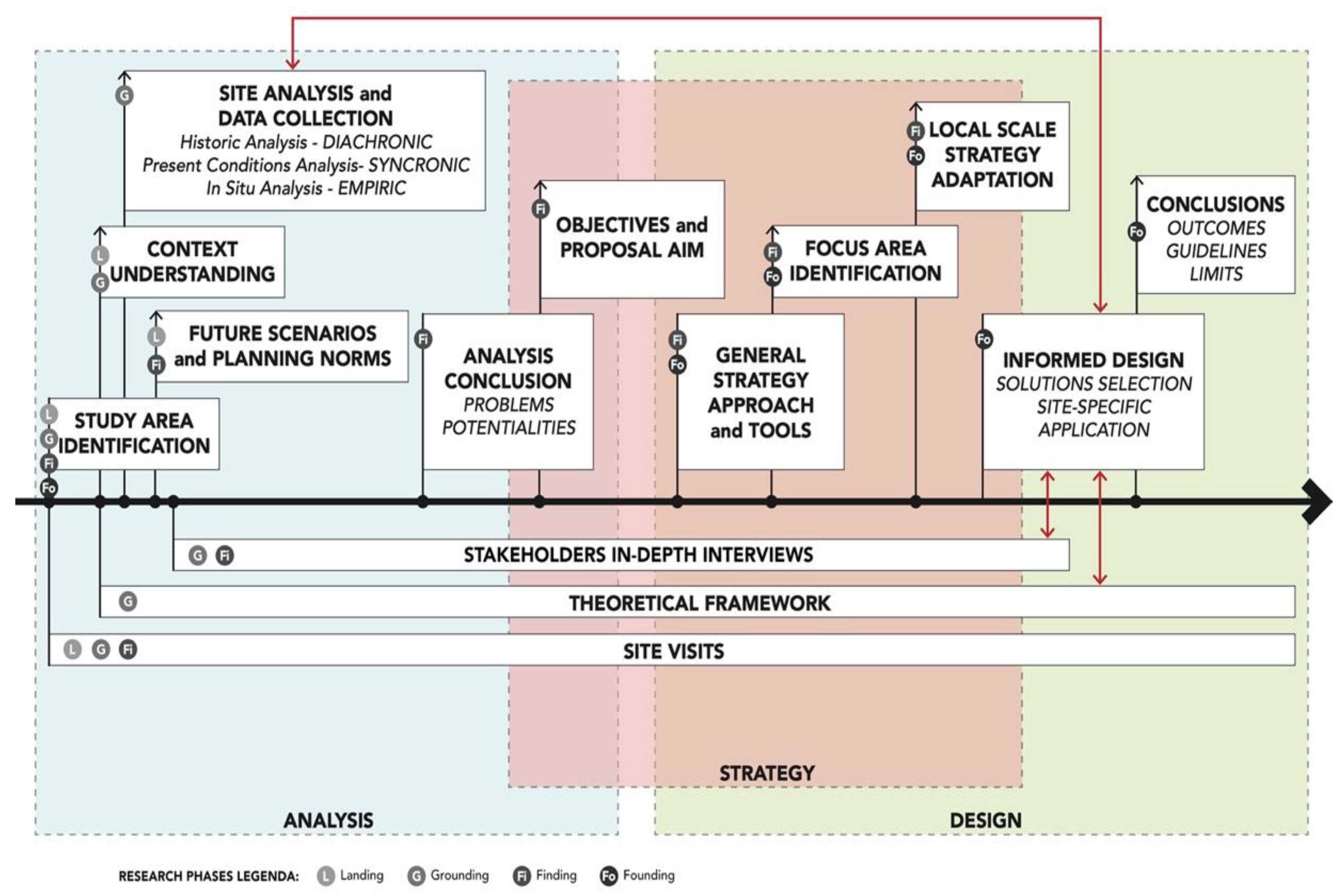
The four trace concepts,
Landing-Grounding-Finding-Founding is a methodology of approaching, discovering, inquiring and making resolutions on a given site introduced by Professor Christophe Girot.
Landing, the first act of site acknowledgement, during which intuition and impression prevail, is followed by
Grounding which entails the study of the site. The act of
Finding is the discovery of distinct qualities of the site and is complemented by the association of ideas, places and themes regarding the site. Finally,
Founding, consists of the synthesis of the previous three acts into a new and transformed construction [design] which interacts with what was already there, as part of the site [
39].
This methodology has been applied in the present approach of the study area as follows:
[Landing]: The research started through a series of visits in situ, where the discontinuities between urban and rural landscape were identified and mapped, as well as the parts of the discontinuous UGI of the area.
[Grounding]: A thorough site analysis, related both to the historical and cultural aspects of the area. It aims at better understanding the context of the site and the functioning and dynamics of the selected urban and rural ecosystems. The analysis was complemented by the study of the theoretical framework, especially related to the urban fringe and the urban-rural relation, regeneration processes and ecosystem services.
[Finding]: A series of site visits, interviews and discussions with local stakeholders and citizens, actively involved in other projects and activities in the area, was carried out along the entire duration of the research. It was revealed to be a key element for the identification of problems and potentialities specific to the site and its possible transformation. The view towards the area formed through the previous phases of the research project was informed by the point of view expressed by the interviewees.
[Founding]: This continuous verification process, not only helped to highlight and confirm the importance and role of the cultural and landscape heritage in the area, but also to understand and enhance both the historical and existing relation and interdependency between urban and rural spaces. This set up a basis for the development of the research and informed the planning and the design process.
The landing phase was kept active throughout the research by carrying out site visits as a way to verify the process and discoveries during the grounding and finding phases. Moreover, grounding and finding took place more akin to an oscillation between an historic and diachronic archive analysis and locals’ interview (
Figure 2).
2.3. In-Depth Interviews as Complementary Urban Analysis Tool
A series of in-depth interviews was carried out to key stakeholders of the area, following a semi-structured and unstructured interview format. In-depth interviews are defined as a qualitative research method with the objective of building knowledge on an area based on deep understanding rather than factual or abstract information [
40].
Such a method was used, especially during the Finding phase of the research process to discover and explore more of the site’s qualities and peculiarities. It concentrated on a qualitative and experiential collection of data and focused on local knowledge and perception of the area with a view to ultimately validating or contradicting the outcomes of the previous analysis phases, namely Landing and Grounding.
This method obtained and compared a range of different perspectives and points of view on the area’s past, present and future development, based on personal real-life experience. It enabled the research team to inform and shape the research quest and design around grounded needs and perceptions. It took into consideration tangible and intangible aspects, which have an important role in the successful provision of Ecosystem Services (ES), especially regarding Cultural Ecosystem Services (CES).
On the basis of the interviewees’ and the COVID-19 restrictions, the interviews and discussions were carried out face-to-face or indirectly (phone calls or video calls). They followed a semi-structured or unstructured format (with different levels of flexibility in the discussion and specificity of questions), on site or in a different location familiar to the interviewee.
In order to capitalize the local knowledge, the stakeholders to be interviewed were selected from local active groups or projects connected to the area, some of which related to urban regeneration projects such as: “Sharing Cities Milano” (Horizon 2020 project) [
41,
42], “Symbiosis” (Urban development project) [
43], “Reinventing Cities Milano” (C40 urban regeneration competition) [
44], “Scali Milano” (urban regeneration project of the abandoned rail-yard of Scalo Romana) [
45]. It also included some others relating to landscape regeneration processes, such as “Parco Agricolo Urbano della Valle della Vettabbia” (park developed as compensation project for the Depurating Facility of Nosedo) [
46], “Vitalba” (organic farm) [
47], “Cascinet Agrarian Society” and “SoulFood ForestFarms” (agro-forestry regeneration project) [
36,
48], “P.O.E.M.A.” (fauna monitoring project) [
49], “Openagri” (UIA—Urban Innovative Actions) [
35,
50], “Milano Porta Verde 2030” (territorial and sociocultural regeneration project) [
51,
52].
The interaction with these key stakeholders not only provided relevant information from different perspectives, but also facilitated access to new data and resources useful for the research (
Table 1).
3. Results
3.1. Mapping the Problems and Potentialities of the Site
The identification of the problems and potentialities of the area was enabled by the simultaneous analysis of historical circumstances and current conditions of the site, through its heritage built and natural elements, its maps and other graphical representations, as well as the memories from local citizens. From this analysis, two main categories were extrapolated and investigated in relation to their links and implications with the local heritage.
3.1.1. Spatial Mapping of Disconnection, Connectivity and Heritage
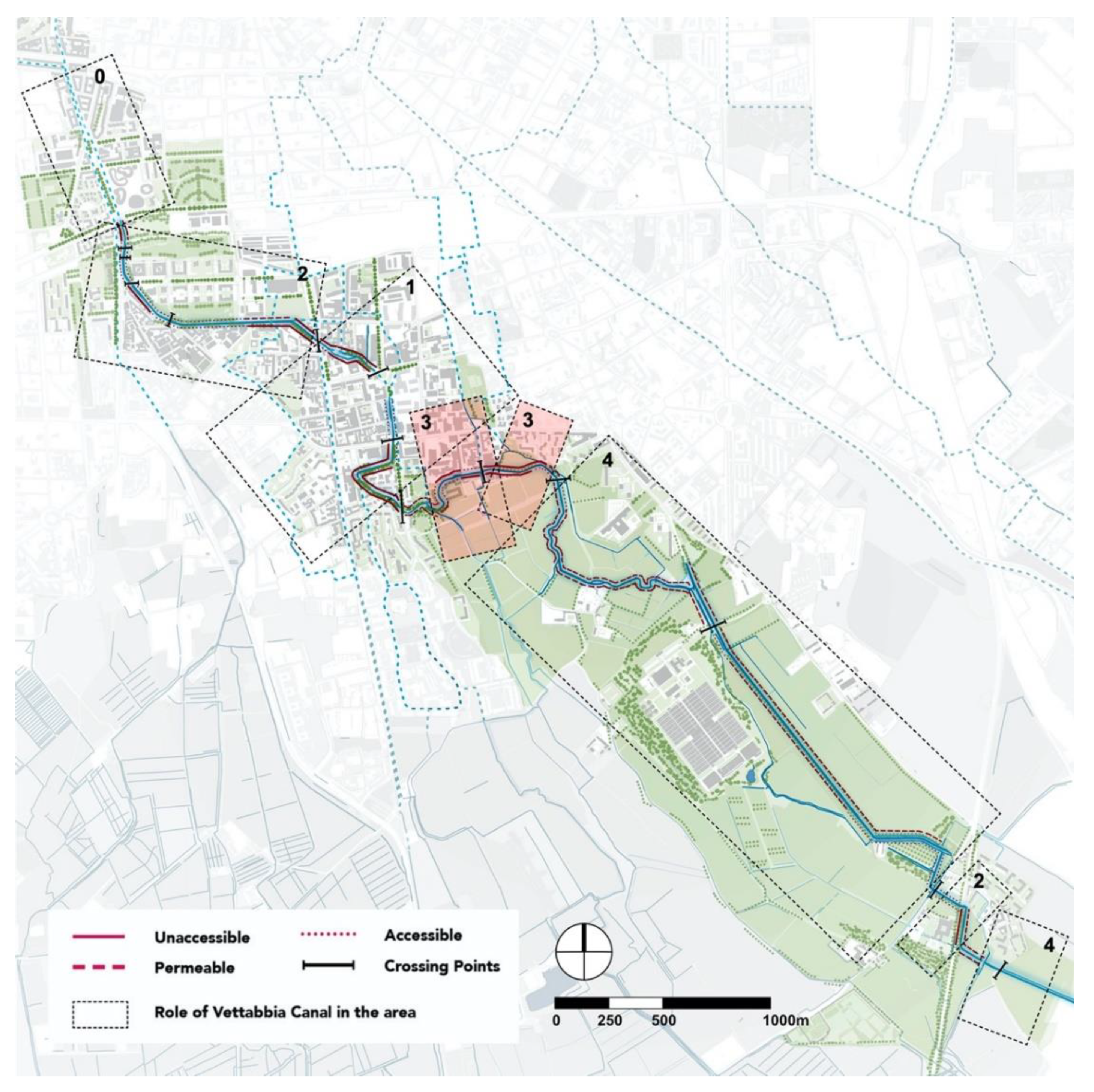
The problem of disconnection and lack of connectivity in the studied site can be clearly recognized through spatial mapping (
Figure 3).
The urban-rural disconnection, due to physical fractures and barriers (
Figure 3c), plays a major role in the definition of the site’s dynamics. It consequently influences the cultural scenario and increases the process of detachment from nature of the local community. This is reflected in the fragmentation of the Green and Slow Mobility infrastructure (
Figure 3b).
As this fragmentation impacts the relation between urban and rural areas and their dynamic interdependency, it is therefore emphatically connected to the loss of landscape and cultural heritage. In this area this loss is not only related to the physical elements and their values per se, but it is also relevant to the role that rural and urban spaces played and still play in the urban fringe ecosystem and their spiritual meaning for the local community.
On the other hand, the pre-existing continuity of the Grey Infrastructure (road network) and Blue Infrastructure (mainly the Vettabbia Canal and its network), inherited from the historical organization and management of the area, highlights the possible connections between urban and rural spaces and sets the basis for the reconstruction of a grid and system which is focused on connectivity.
The Vettabbia Canal here plays a crucial role, both in terms of a physical link and landscape element but also as a cultural heritage backbone for the site (
Figure 3a).
In juxtaposition to the barriers identified in the area, it’s possible to notice an archipelago of existing nodes and centers (
Figure 3d), related to urban functions, cultural activities, and rural elements, that reveal the inner identity of the area, yet to be enhanced.
Moreover, the enhancement of the connectivity among Green and Blue Infrastructure elements as well as between rural landscape and slow mobility networks inside the urban tissue, is a way of promoting healthy ecosystems and Nature-Based Solutions (NBS), biodiversity, sustainability, and Ecosystem Services (ES).
The systematic integration of these factors in the further planning of the urban fringe is in accordance with the policies comprised the Green Deal’s Biodiversity Strategy [
4,
7,
8,
9].
3.1.2. Environmental Quality and Heritage
The problem of poor environmental quality of the site poses the issue of Ecosystem Services provision and biodiversity development, and how they could be improved by enhancing currently abandoned or neglected areas.
If on one side within the urban tissue, the open space quality is reduced by a low percentage of green and safe available spaces for the inhabitants, on the other side the environmental quality of the rural area is once again strictly connected to the heritage of the site, in particular to the agricultural heritage and its landscape typologies.
The gradual loss of landscape features or structures typical of the rural environment of this area, such as the “Marcita” (original field irrigation system, based on a series of gentle slopes and dikes to ensure a continuous water flow over the cultivated portion of land), and the growing uniformity and monotony of the rural space, has modified the balance of the local ecosystem, reduced the flora and fauna biodiversity or prevented the provision of other important ES at the local scale.
In contrast to this general condition of abandonment, both in the urban and the rural sides of the studied area, several projects are currently implementing new innovative regeneration actions and participatory activities [
36,
42,
48,
50]. They involve the local multicultural community and show the local interest and commitment against the neglect of the research site’s open spaces.
The highlighting of cultural heritage relicts and lost practices, for making the city’s outskirts safe, resilient, and inclusive—towards the pluri-cultural inhabitant’s society and the wider public—is a means to tackle Sustainable Development Goal 11 [SDG11] through the prism stated by ICOMOS [
31].
3.2. General Overall Strategy
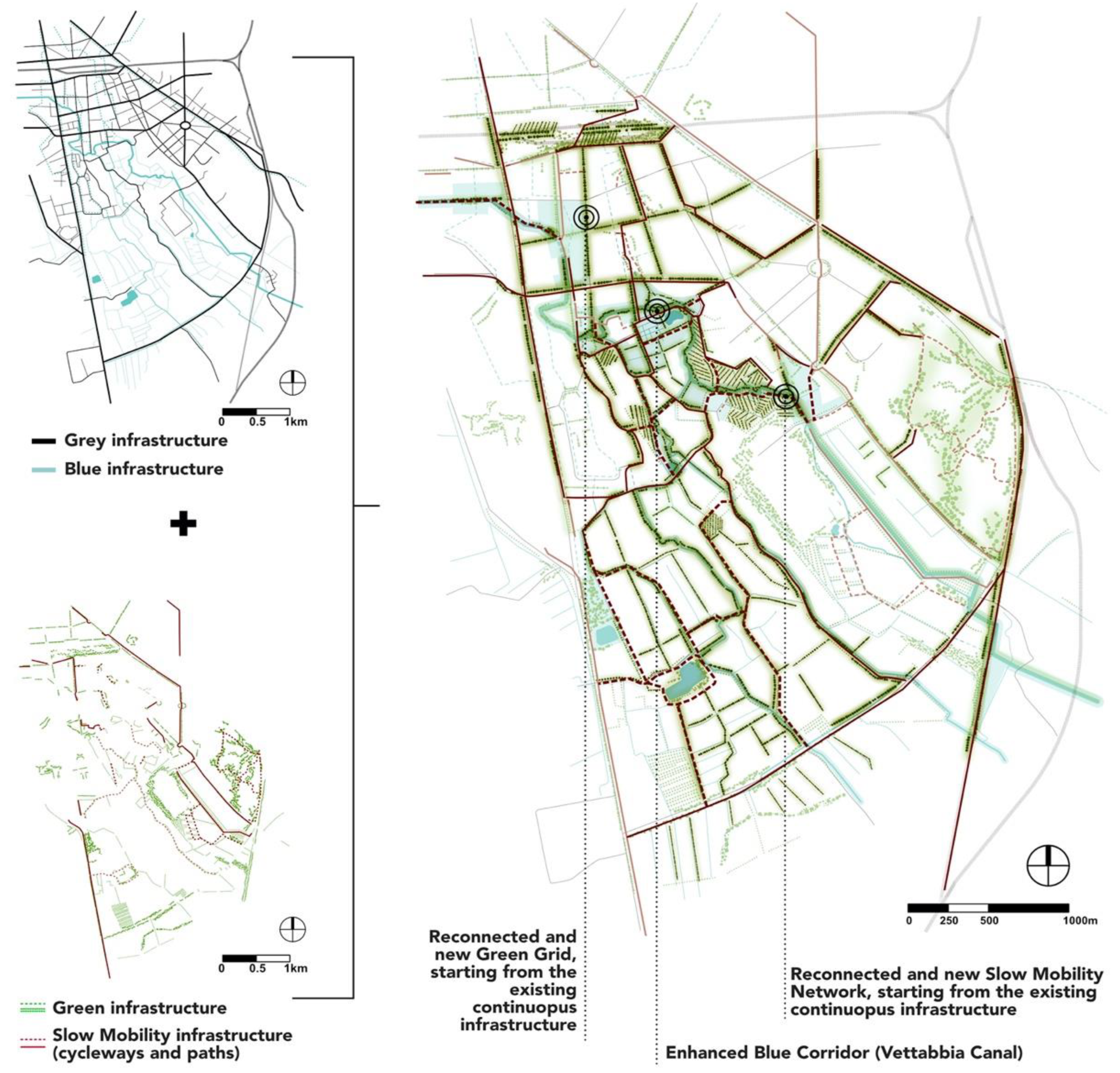
3.2.1. Repairing Connectivity
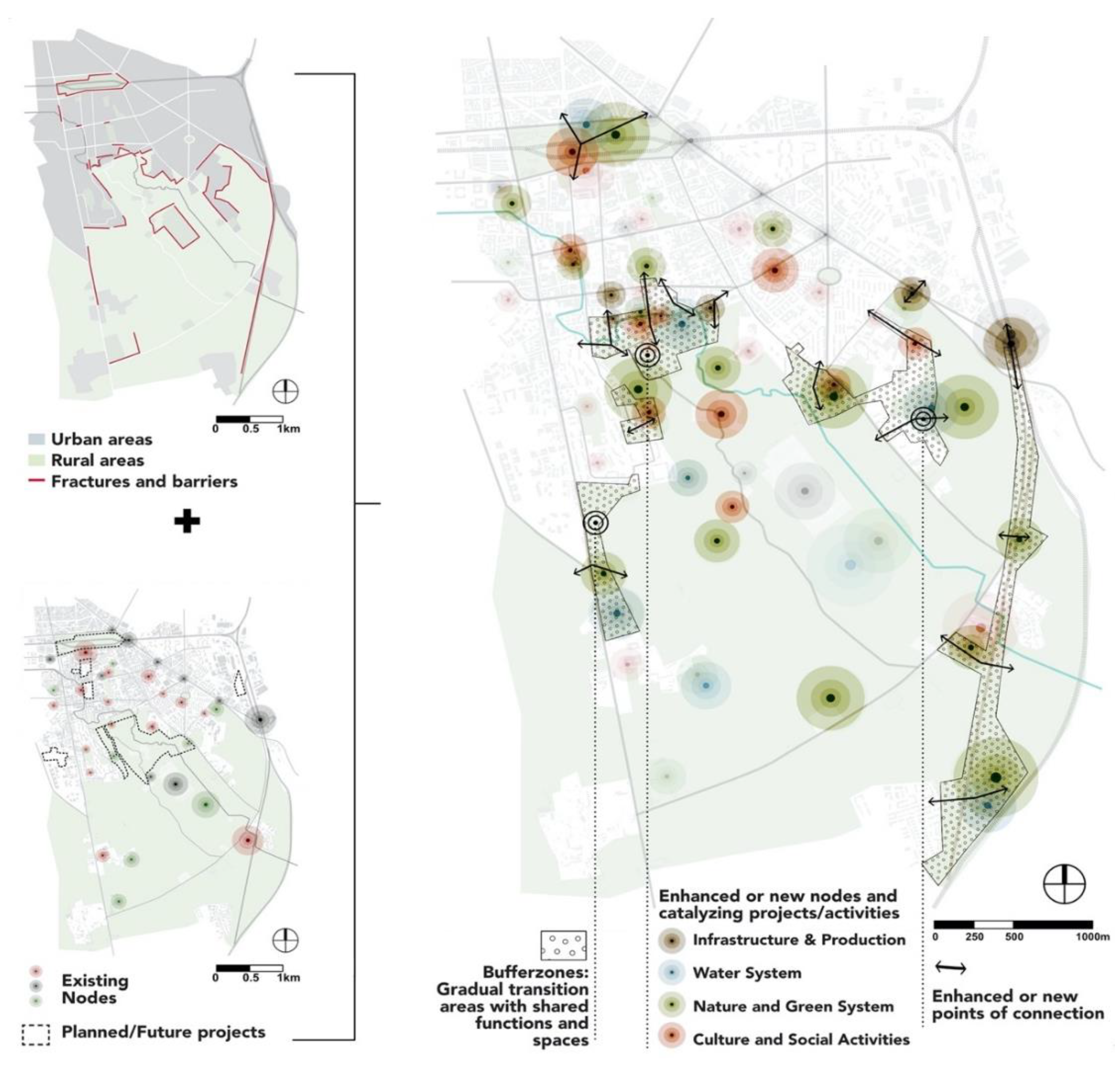
The following map (
Figure 4) shows one of the main aims of the overall strategy: creating a continuous Green Infrastructure system, starting from the existing continuous networks (Grey and Blue) and using them as a base to repair the fragmented networks (Green and Slow Mobility).
Green and Slow mobility infrastructures need to be combined and complementary, to enhance biodiversity and improve a numerous series of other ES related to the green spaces. This fulfills the goals of the Green Deal’s biodiversity strategy [
7,
8,
9]. This is also a way of improving the connectivity of the entire site, ensuring accessibility both to these spaces and also to the ES provided.
The historic Vettabia Canal, in this vision, reconquers the role of landscape structuring element and backbone in the urban fringe (
Figure 5) and reveals its potential role as a stitching together element between rural and urban landscape. This is in contrast to the present conditions where it represents a barrier and dividing element between urban and rural landscapes. Mutual accessibility between
rural and
urban augments the site’s resilience, sustainability, and inclusiveness, echoing SDG11 [
31].
3.2.2. Transition Zones and Nodes
The following map (
Figure 6) presents the existing urban-rural relationship and foresees a new interaction between these two landscapes. An
infiltration strategy is deployed [
18], as a means to establish transition zones between urban and rural landscapes.
The existing reading of the area focuses on two main spatial configurations: linear and nodal. The urban and rural areas are highlighted as two discrete entities, together with the linear limits and barriers that separate the two. The main nodes and attractions of both are marked (classified as natural, cultural, infrastructural), and display their relative hierarchy. The overall strategy identifies strategic areas which can function as buffer zones, where rural elements can infiltrate in the urban tissue and where the transition between urban and rural landscapes can be further developed.
The identified need of connectivity enrichment within the area of study leads to the proposal of new nodal and linear solutions to complement the existing diffused network. In particular it envisions the integration of new nodal catalyzing elements—in relation to natural features, green corridors and human accessibility—to create a network of nodes., as well as the tracing of lines of connection (vectors of connection) that represent the strategic and crucial location of exchange between urban and rural spaces.
3.3. Landscape Strategy: Masterplan Scale
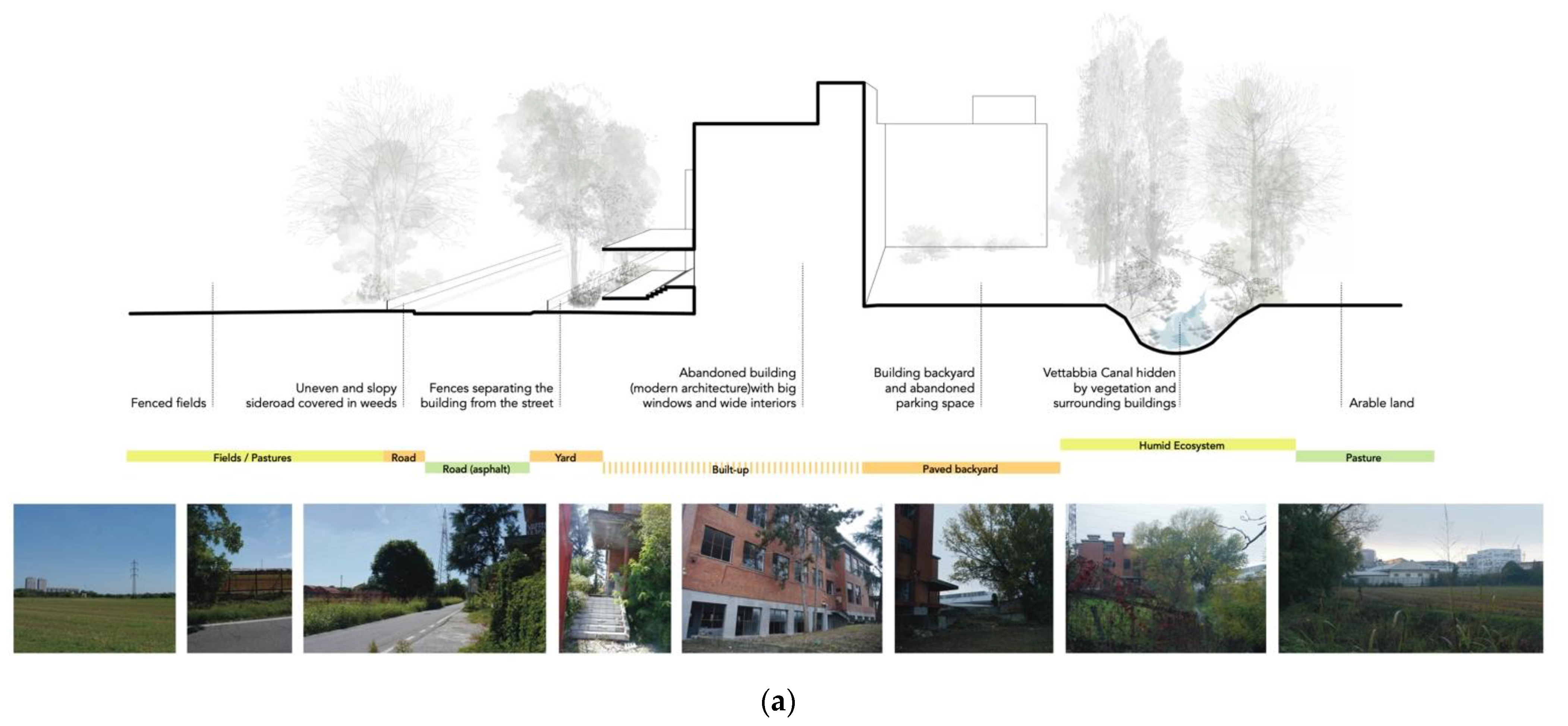
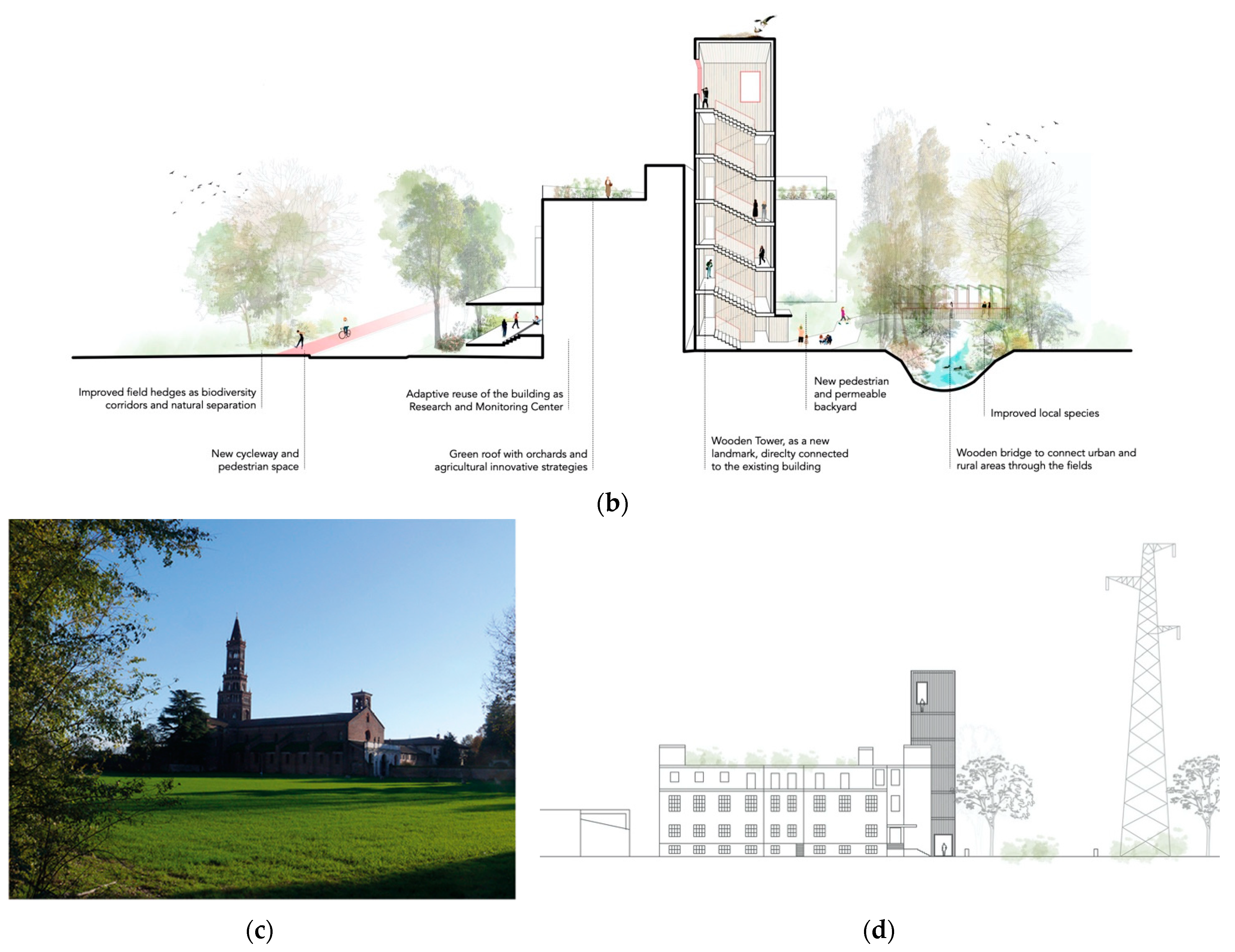
Once a general overall strategy was developed at the neighborhood scale, a specific area was identified as the most strategic location to investigate a site-specific approach for the urban-rural transition mentioned above. Indeed, these research objectives are precisely the reversal of the dividing character of the Vettabbia and devaluation of unused spaces. This reversal can be carried out through the activation of such areas as diachronic and heritage landscape and architectural elements, which actively stitch together urban and rural landscapes, and connect UGI elements.
The selection of this specific site derives from the function that the Vettabbia Canal holds nowadays in this specific area, which is a very significant and unique characteristic. It functions as a spatial element of division between urban and rural. Moreover, this specific location represents a key site for connectivity improvement and urban-rural transition, not only for the availability of abandoned spaces eligible for possible regeneration, but also for the presence of several agricultural landscape and architectural heritage elements. These offer the possibility of including, within this research, the very important cultural heritage factors.
The study on this scale represents a crucial link between the role of the GI network and the twofold role of NBS as site-specific solutions and simultaneously as part of a broader coherent system.
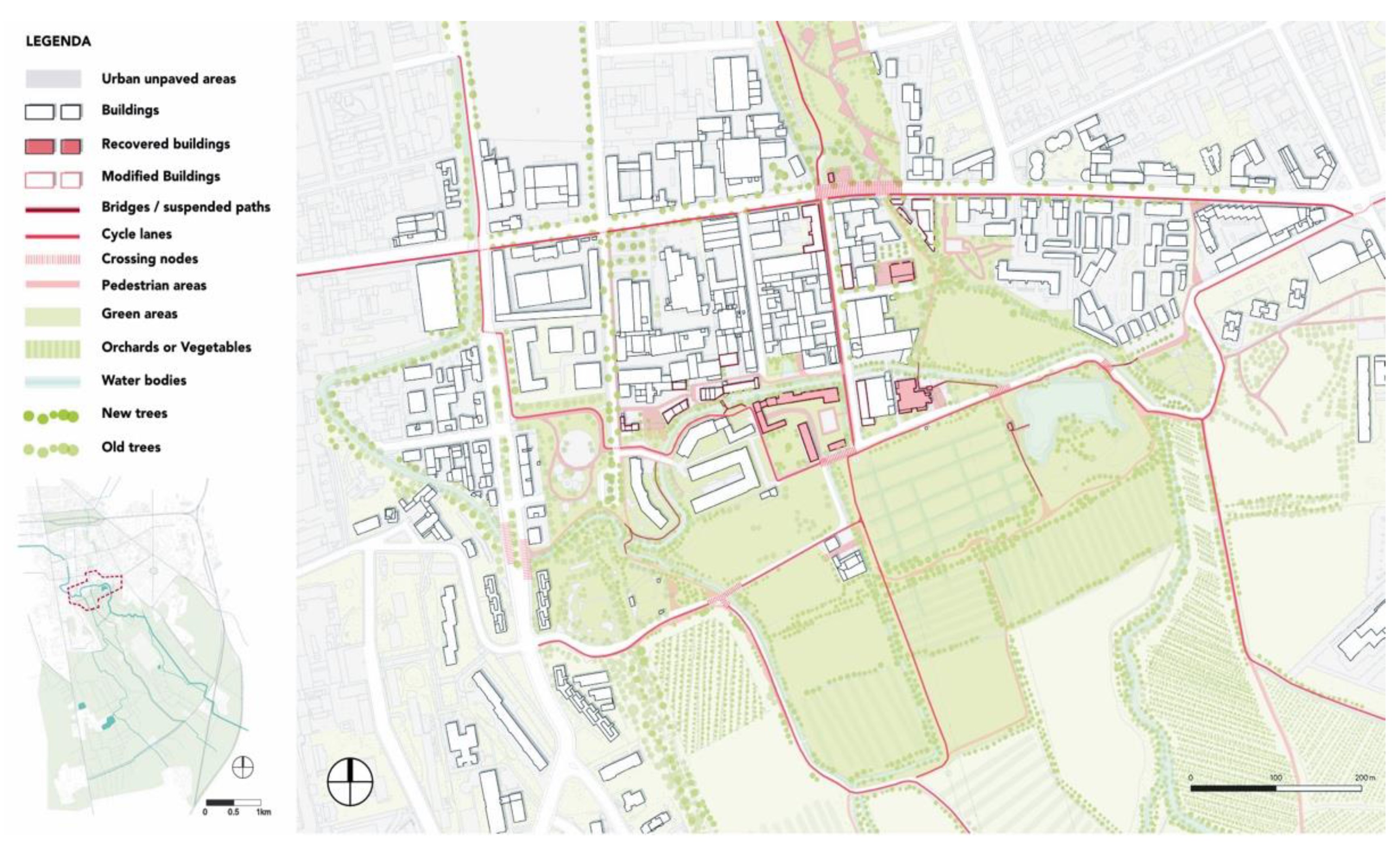
The design-based research on the area (
Figure 7) highlights how the rural qualities can infiltrate into the urban fringe tissue, by virtue of reclaiming and adapting abandoned agricultural buildings and structures together with their adjacent spaces. This has the goal of smoothing the edges between built and open spaces. It softens the discontinuity caused by urban sprawl within the urban fringe.
Accessibility and connectivity are also ensured by specific hardscape interventions, such as bridges, pedestrian paths and cycle lanes.
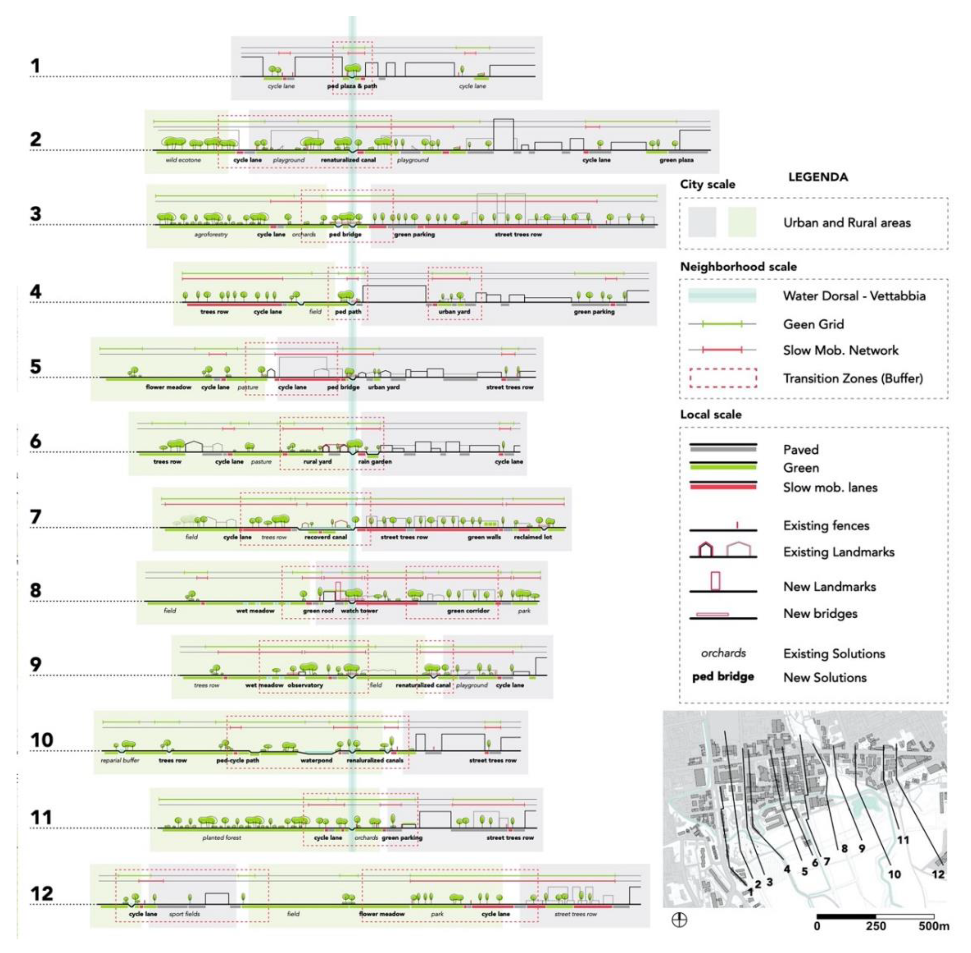
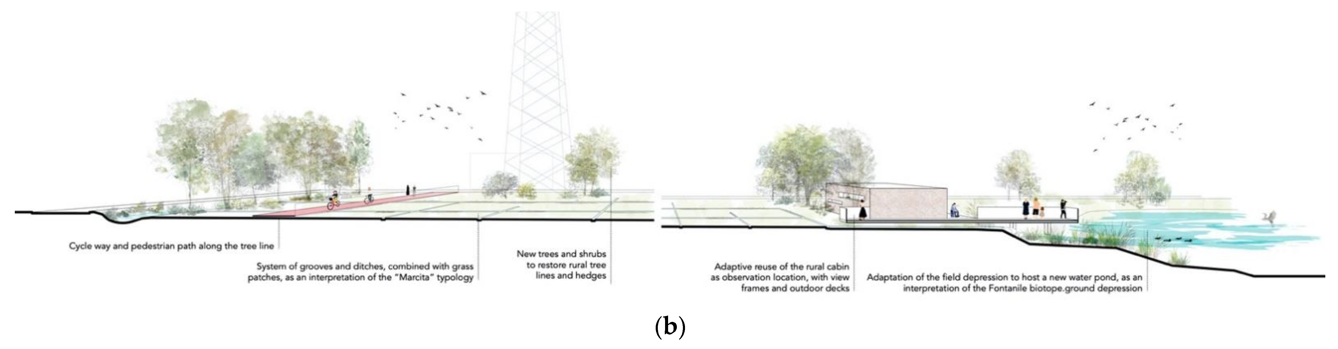
A series of sections (
Figure 8) helps to understand the relation between urban and rural spaces. It shows how even small design interventions can completely modify the balance of the public space and give new importance to previously marginal or unused areas which are characterized by poor environmental quality and low accessibility.
From the sections it is also possible to see how the Vettabbia Canal, as previously described in the framework of the general overall strategy, acquires a central role and becomes the linking element, of the linear core where all the new spaces are directed and focused.
3.4. Landscape Strategy: Nodal Scale/Different Characteristic Typolgies of the Area
As described in the previous chapters, the overall strategy used throughout this research was based on two different types of spatial configuration: linear and nodal. In particular, the latter was investigated more in detail, to suggest site-specific tailored solutions.
Three main typologies were identified, as characteristic of the area and representative of the local rural landscape and architecture heritage.
The introduction of a diffused program which is largely based on agricultural practices, creates within the urban fringe a network supportive of Urban and Peri-Urban Agriculture [UPUA]. This network is a way to address the manifold goals of the Green Deal’s Farm-to-Fork [F2F] Strategy. These include: the accessibility of quality food by the area’s inhabitants, sustainable food production, the production of food with high nutritional value, and the mitigation of climate effects (by avoiding long-distance transport) [
15].
Simultaneously, by re-activating through UPUA disused fields within the urban fringe, and by treating/cleaning and re-using the Vettabia canal’s water, the preservation and restoration of the land and freshwater resources on which the food system depends could be achieved.
The latter is another major goal of the F2F Strategy, along with the mitigation of climate change and adaptation to its impacts, the protection of land, soil, water, air, plant and animal health and welfare, and the reversing of the loss of biodiversity. These are also among the benefits of the strategy deployed by this case study at nodal scale, as analysed in the following subchapters [
25].
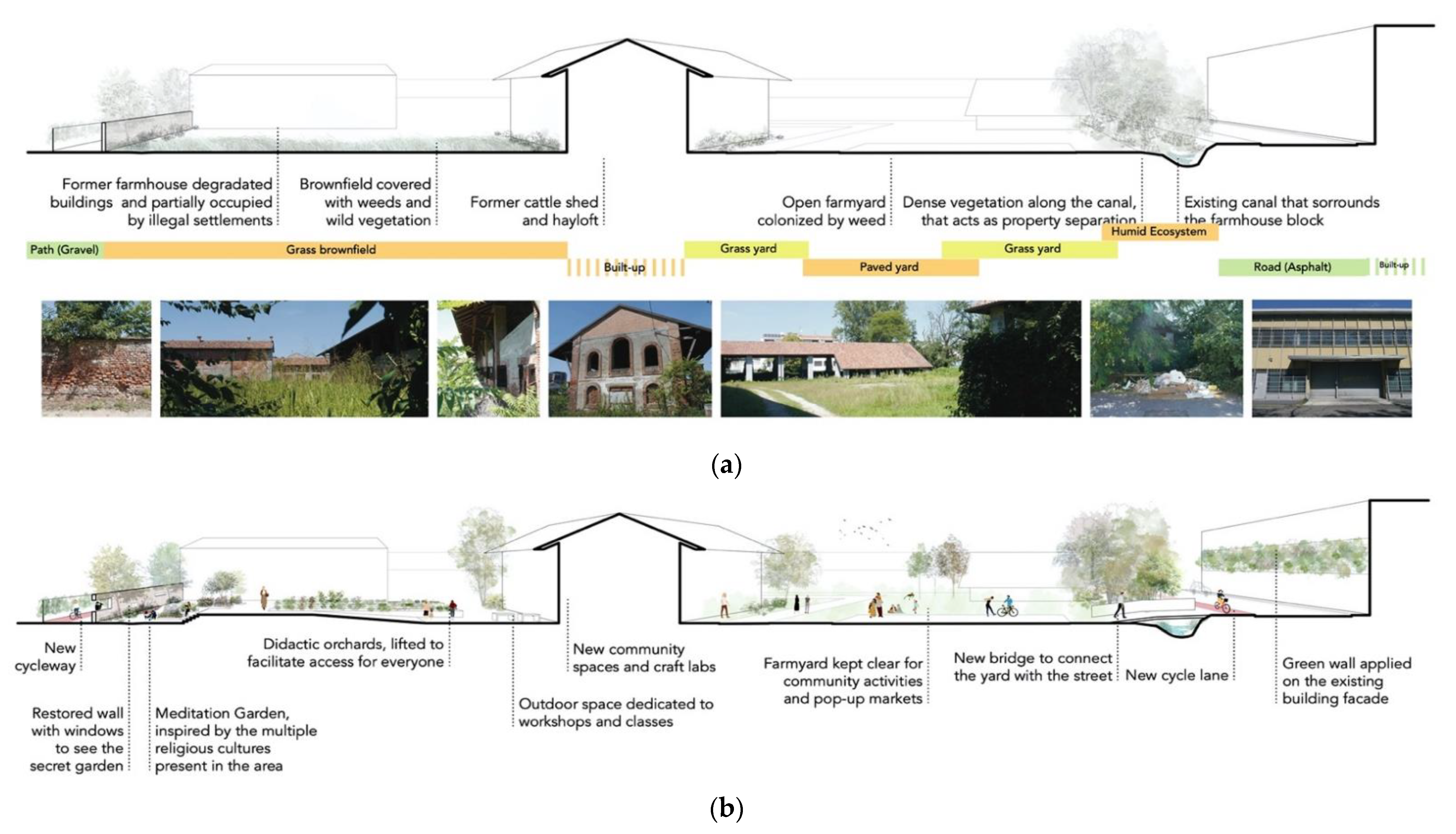
3.4.1. Enclosed Yard Typology
This typology refers primarily to the historical agricultural and architectural heritage related to the rural area, inherited from the religious orders’ management of the site’s lands throughout the centuries. Their management was carried out using clusters of monasteries and affiliated farmhouses. Such buildings would be constructed around an open common space, most frequently developed as a garden with religious and productive functions.
The location chosen for the design corresponds with one of these clusters. It is currently abandoned or occupied illegally, and some parts of the buildings are derelict.
It represents a crucial project location, not only for its location between urban tissue and rural fields, but also for its relationship with the water system of Vettabbia and for its symbolic value as rural landmark and culture center.
The suggested idea is to create a vibrant cultural and agricultural center open to the public. It will act as a point of connection between typical urban activities and agricultural practices, and also as a common ground and meeting point for different communities and cultures existing in the area.
The sections (
Figure 9a) highlight the relationship between open and built spaces and the existing conditions to be improved through the design.
In the proposed design (
Figure 9b), one of the block yards hosts The Multicultural Community Garden, a place where orchards and meditation gardens are combined in order to foster a dialogue between all the site entities (religions, culture and agriculture heritage, etc.).
The enclosed environment created by the buildings and walls around this space, complemented with a light topography intervention, give the possibility to create a more open space for orchards and didactic activities, in contrast with a more intimate garden zone.
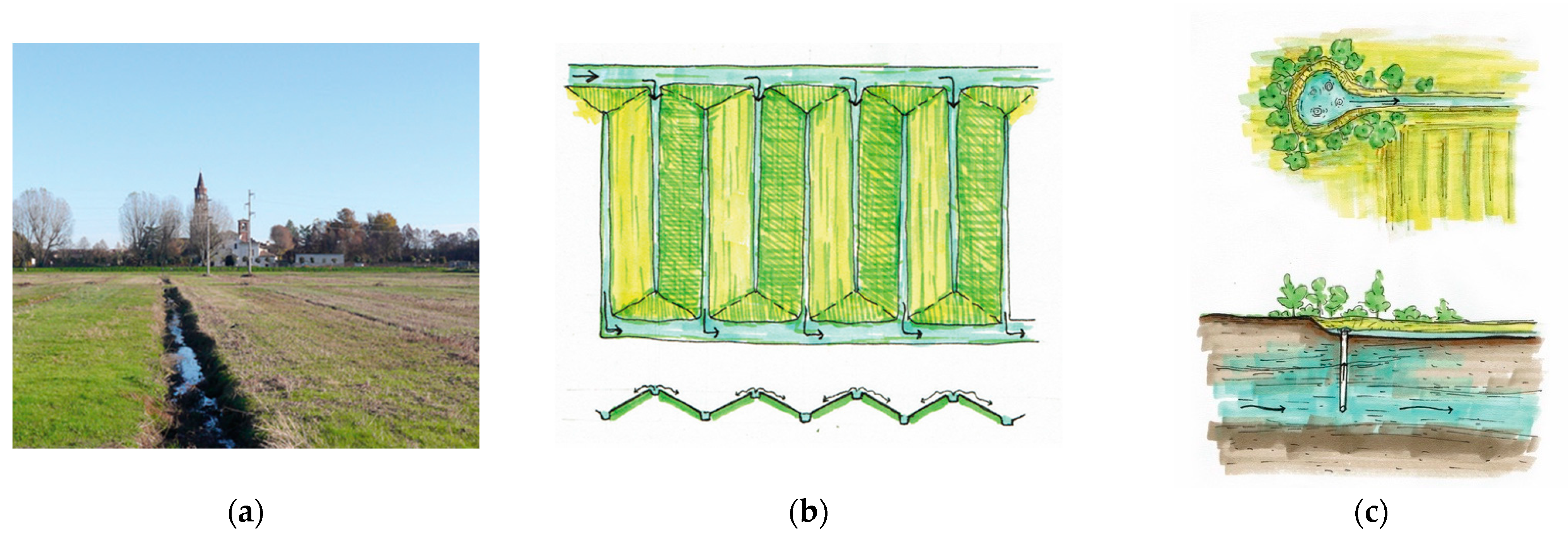
3.4.2. Marcita and Fontanile Typology
This typology refers to two local traditional agricultural landscape structures:
Marcita (
Figure 10a,b), a wet meadow where the water is provided in a uniform way in the fields by shaping the ground into oblique planes, thus creating a slow and constant flow and enabling the soil and plants to absorb and filter the water coming in;
Fontanile (
Figure 10c), a technique with tubes inserted in the ground, used to encourage the resurgence of spring water, which is collected into limited ponds or swampy plains and then is channelized and redirected to the fields.
The design proposal (
Figure 11b) aims at creating new agricultural heritage inspired landscapes and recreating similar biotopes to support and improve the local ecosystem.
The resulting field represents a buffer zone between the urban space and the rural area, where many flora and fauna species can find their habitat and where the Vettabbia water can be filtered before being directed to different uses or back to the hydrological system.
The water is taken from the Vettabbia canal through the existing irrigation canal, located next to the field. The excess water is collected into perimeter ditches that redirect the flow to the nearby fields and into the new project pond, created where an existing topographic depression is located (
Figure 11a).
The processed and cleaned water ensures the creation of a higher quality biotope that can attract and welcome a more diverse range of species. The entire area is historically characterized by water and humid habitats; thus, the native flora and fauna still present in the area are typical of these environments.
Placed along the pedestrian paths, or in strategic locations, such types of intervention would restore the area’s past character of water-based landscape. It would, bring back its local landscape heritage both through landscape design and also education about the area’s history and environment.
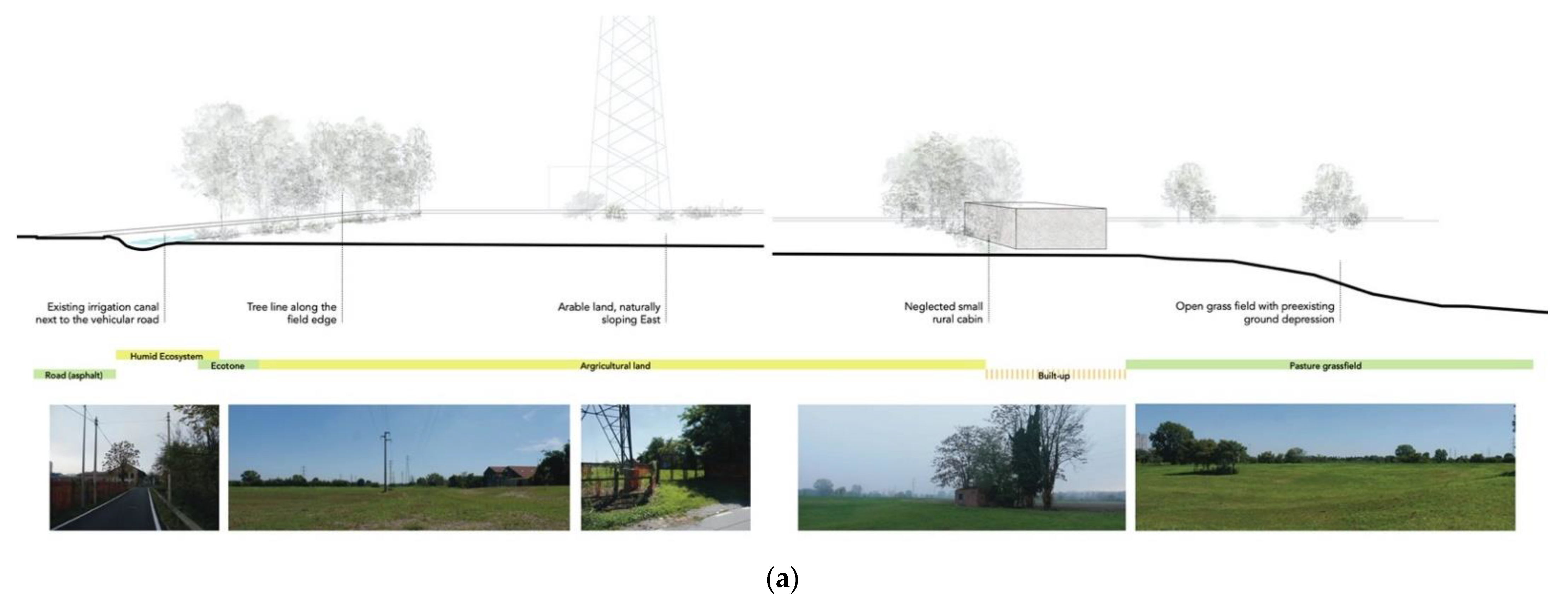
3.4.3. Tower Typology
This typology refers to the traditional architecture and landscape heritage of the area, related to religious buildings, namely the bell towers of churches and abbeys located around the rural flatland (
Figure 12c).
The idea is to create a vertical landmark, inspired by the local landscape heritage and typical character related to religious buildings. However, this time it would be devoted to a different function, one that can answer the contemporary needs of the area, by keeping the strong physical and visual relation with the natural landscape of the surroundings.
The verticality of this element is also intended to be a focal point in the skyline of the urban fringe. It would make the entrance point to the agrarian park more visible, both from the urban and the rural side.
The watch tower proposed in the design represents a new construction, a juxtaposition to an existing three-storey building, which is currently abandoned (
Figure 12a) and intended to be reclaimed and reused in the project as a research/monitoring center.
The structure is 25 m high and is made of wood. It hosts a staircase to reach the viewpoint on top. It functions as a platform for the surrounding rural and peri urban areas. It is directly connected to the building but is also accessible separately by any external visitor (
Figure 12b).
A pedestrian bridge over Vettabbia Canal and a continuous pedestrian path, connect the watch tower with the slow mobility network of the surroundings, and thus becoming a hinge point for the site.
4. Discussion
The results presented highlight the value of this study within the existing literature. The multiscale and research-by-design approach used in this study produced a series of guidelines, on how to introduce GI, UGI and NBS in peri urban areas to address the urban-rural transition and tackle the agricultural fragmentation of the territory in a more sustainable and resilient way for the local community and ecosystems. Moreover, the site-specific examples provided demonstrate the crucial role that the local heritage, in terms of traditional agricultural practices and landscape typologies, can have in fostering the regeneration of urban fringes, through the reuse and rehabilitation of abandoned spaces.
All these elements can contribute to give a practical response, applied to peri-urban areas, to the Green Deal and the related policies addressed in this study, such as the Biodiversity Strategy and the Farm to Fork, which are abstract and theoretical, paving the way for innovative and combined urban and rural planning and design strategies.
4.1. Connectivity of UGI and NBS within the Urban Fringe
Fragmentation of Green Infrastructure [GI] networks have been identified as one of the major degrading agents in the urban fringe of South Milan. This unfortunate characteristic of urban fringes in many European counties [
9,
10] can be reversed by the enhancement of connectivity between existing parks and green clusters of the area of research [
9,
11].
Furthermore, the research proposes an enhancement of the connectivity of urban and rural landscapes, and existing green clusters or disused buildings, on both sides of the urban fringe, along the Vettabbia canal and their mutual regeneration using Nature-Based Solutions [NBS].
The Vettabbia canal is a diachronic landscape element—a waterscape—which has played a crucial role in the area during the past. Yet today its environment is disconnected from the urban tissue and is degraded. Vettabbia functions today as a boundary between urban and rural landscape.
By re-establishing the role of the Vettabbia, and making it this time the backbone which links the existing urban fringe’s urban green clusters, an Urban Green Infrastructure [UGI] network is deployed at its northern—urban—bank. Simultaneously, the Vettabbia can function as a bridging and stitching together element between the UGI network and the Parco Agricolo Sud, thus playing a crucial role in the promotion of biodiversity and the provision of lost Ecosystem Services [ES] within the urban fringe.
In this way, valuable characteristics of the rural landscape can infiltrate the urban periphery, creating a condition of ‘infiltration’ of the rural qualities into the urban tissue, and halting the negative impact of urban sprawl. This research proposes therefore, in the context of urban fringes, the implementation of an ‘
infiltration’ strategy [
19] which can provide a multiplicity of optimal outcomes.
Furthermore, the presented research-by-design entails the introduction within the urban fringe of UGI and GI networks and the invigoration of still existing and historical agricultural soils. All this while encouraging the recovery of the artificial types of wetlands [marcita and fontanile] which were associated with the traditional agricultural and livestock production of the area.
The methodology proposed can be considered as a means of including the cities in the effort to stabilize the climate, which a revised European Green Deal [EGD] should consider as a predominant factor [
33].
The Biodiversity Strategy of the [EGD] suggests, amongst others, the systematic inclusion of NBS in urban planning [
25]. The role of Nature-Based Solutions [NBS] in the proposed research by design can be associated with all 3 types of NBS:
[NBS1] Include approaches which preserve existing ecosystems,
[NBS2] Include actions to enhance and build sustainable landscapes,
[NBS3] Include intensive management of ecosystems and the introduction of new ecosystems [
12,
13].
The proposed NBS—analyzed in the Results—can be thus classified as follows:
[NBS1] are implemented in the non-degraded parts of the Vettabbia canal which become interconnected, and their respective existing ecosystems maintained, leading to an enhancement of the urban fringe biodiversity. The Peri Urban Agriculture [PUA] is maintained within existing agricultural fields.
[NBS2] are implemented in those parts of the Vettabbia canal which are disconnected from the urban fabric. By means of their connection with the existing green clusters of the area they become part of the UGI network. The part of the Vettabbia which is in the urban fringe is thus considered as a whole and takes the role of the GI network backbone. Furthermore, among the [NBS2] implemented are the enhancement of areas adjacent to the Vettabbia by the application of UA and PUA practices, which promote rural landscape biodiversity enhancement, and a sustainable food system, respectively, replying to the Biodiversity Strategy [BS] and Farm-to-Fork F2F Directives of the EGD. Jointly, the use of permeable surfaces along the urban surface which forms the northern bank of the Vettabbia and in the urban network of public spaces, contributes to the mitigation of climate change effects.
[NBS3] include the re-creation of a marcita-type field and a fontanile-type lagoon. These are features of the agricultural heritage which has disappeared from the area, and thus the introduction of a type of ecosystem which historically existed, promotes rural Biodiversity and the revival of a series of joint ES [
30].
4.2. Agricultural Heritage within the Urban Fringe
First and foremost, the agricultural heritage regeneration is tackled through the management of the Vettabbia canal, which has played diachronically a role of bonding urban and rural landscape. Furthermore, by considering the traditional agricultural practices as producers of environmental typologies and encouraging communities to become involved into the safeguarding of peri-urban agricultural landscape, multiple aspects are triggered simultaneously [
30]. The following agricultural heritage typologies have been used as a characteristic reference to traditional agricultural architecture complexes and landscape features:
Building and landscape typologies, which are referent to agricultural heritage practices, are taken into account in designing the re-activation of disused buildings and of their surrounding spaces, into the urban fringe. From the enclosed monastery yard typology stems the concept used in the design of community gardens in enclosed pluri-functional yards open to the public and the local community. These gardens aim to induce the engagement of the inhabitants belonging to the local pluri-cultural society with UA practices, whilst providing them with a series of ES [provisioning, supporting, regulating, cultural]. Taking into account that UA practices contribute to social cohesion and inclusion, foster gender equality and socialize newcomers in multicultural and pluri-ethnical frameworks [
20,
21] a way to harness the potential of the area’s agricultural heritage is attempted It aims to render the urban fringe along the Vettabbia inclusive, safe, resilient, and sustainable, meeting the SDG 11 through the prism stated by ICOMOS [
31].
Building typologies, which are symbolically linked to the rural plain landscape, such as the tower typology, are taken into account in defining the urban fringe thresholds. The tower consists of a landmark reminiscent of bell towers in the fields, and moreover an archetype of the vertical element which projects in a horizontal plain’s rural landscape. The demarcation of an important ‘gateway’ in the border of the urban fringe by the addition of a tower can signal, from a distance, the bridging of the former urban-rural gap, through a slow mobility network. The tower, as a viewing device, can be further used for monitoring the evolution of biodiversity in the rural periphery, creating the possibility of bird watching and of signposting the building it is attached to, where environmental monitoring and educational practices are proposed to be hosted. The attachment of newly designed structures which stand-out, in old disused buildings of the area, could be a way to signal their refurbishment, and manifest their new use, in order to attract the community. In addition, by reusing and regenerating disused building stock, the negative social consequences of urban decay, associated with disused spaces, is addressed [
32].
Landscape and waterscape features, which are inspired by the function of traditional heritage elements such as the marcita and fontanile, which used to be among the traditional features of the local rural landscape, are taken into account in enhancing the local ecosystem. Such landscape features were characteristic heritage elements of the site and, unfortunately, have disappeared along with the rich network of ES they procured [
30,
53]. Marcita and fontanile can boost biodiversity as they entail functions which are nowadays attributed to NBS such as: plant-based water treatment, wetland ecosystem development, and pasture growth throughout most of the year. The introduction of a new water pond which is linked to a designed marcita-type field and fontanile-type pond, creates a blue infrastructure network which cleanses water and can assemble and provide shelter to species of fauna and flora which used to be flourishing in the marcita and fontanile micro-environment. The introduced blue-infrastructure network is addressed to the community, as a means of environmental educational infrastructure, while it can also be supportive of the development of UPUA in the urban fringe area. Moreover, by monitoring the marcita-type field, where the Vettabbia water is cleansed before entering the pond-reservoir [and providing water for UPUA], the observation of the water quality of the Vettabbia water can be controlled.
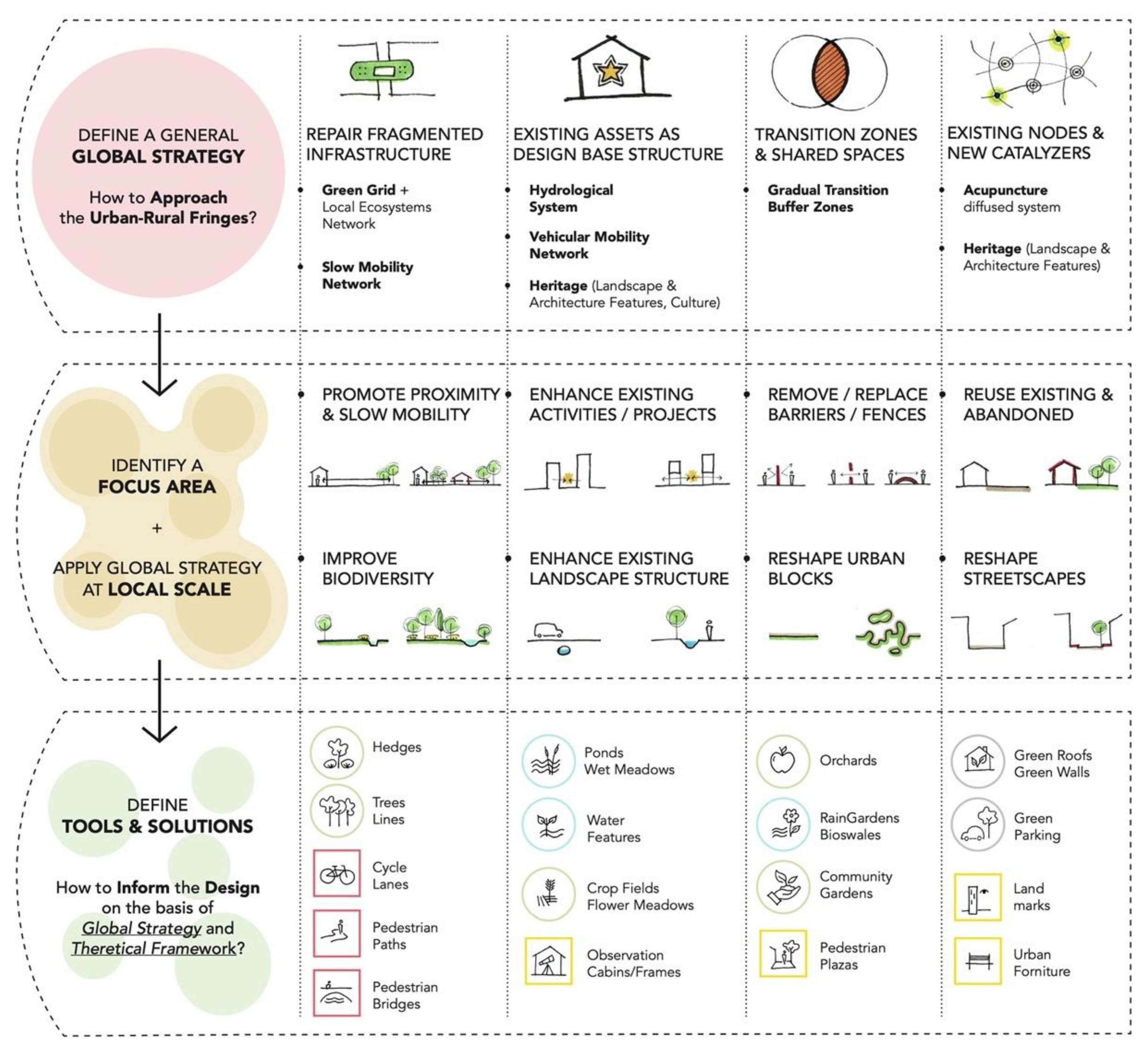
4.3. Planning and Design Guidelines
As a result of this research, a methodology was developed, with planning and design guidelines on how to approach urban fringe regeneration processes, stressing the inclusion of solutions such as the abovementioned [
Section 4.1 and
Section 4.2] within the GI and UGI networks, to tackle the factors that pressure and impact agricultural land and increase fragmentation and ES loss phenomena. This methodology was developed based on specific problems and potentialities characterizing the study area. However, the final model results in a series of more general guidelines that could be applied and tested in other case studies, with necessary adaptation measures, to fit a different context.
The methodology presented (
Scheme 1) is divided into three main phases, each one characterized by a different scale of approach and composed of a series of actions. All the phases and actions are to be considered interconnected and interdependent.
The first phase foresees the definition of a general strategy that addresses the urban fringe regeneration at a wider scale. In this case it coincides with the extended neighborhood area. At this scale, four main actions are identified, and each is detailed with site-specific examples, as follows:
identification of the site’s fragmented infrastructure to be repaired, in this case the Green Infrastructure and the Slow Mobility Network;
identification of the site’s existing assets to be used as the basis of design, in this case the Blue infrastructure, the Vehicular Mobility Network, the Landscape and Architectural Heritage and the Multicultural and Pluri-ethnical community;
identification of the site’s transition zones and shared spaces within the urban fringe landscapes, in this case the Buffer Zones between urban and rural landscapes;
identification of the site’s nodes and possible catalyzing elements, in this case the diffused system of socio-cultural activities and the landscape and architecture landmarks relating to the local agricultural heritage.
The second phase foresees the identification of a focus area, where the general strategy is to be applied at a local scale. Each of the previous phase’s actions is detailed here on the basis of the identified local needs. This is in order to provide a set of generalized but tailored suggestions for the implementation of each action at the local scale, such as:
the repair of fragmented infrastructure through the promotion of the proximity of slow mobility and green spaces;
Use existing assets as the design basis so as to capitalize on their potential. This is carried out by means of the enhancement of existing projects/activities and landscape structures;
The creation of transition zones and shared spaces by means of the removal of barriers and the reshaping of urban blocks;
The creation of nodes and catalyzers through the reuse of existing and abandoned spaces/buildings and the rearrangement of streetscapes.
The third and final phase focuses on the design of small spaces. The aim is to define a set of tools and solutions that can work on multiple scales and tackle site-specific issue while being integrated and connected to the general strategy approach. In fact, these types of solutions—such as the NBS and Landscape Architecture Tools mentioned in the previous sections—have an important role per se, but at the same time they represent the fundamental components of a wider network such us the GI and UGI [
9,
11].
5. Conclusions
This article displays a method by which a multiscale reading of the urban fringe, which investigates the present pressures and conditions, along with a historic overview of its characteristics, can highlight its predominant diachronic landscape features.
Regarding the research area, the local traditional rural and architectural elements were selected based on the site’s particular features. In the case of replication in a different site, similar but site-specific elements should be identified, and the methodology adapted to the local idea/characteristics. Based on these findings, an overall strategy can be articulated comprising multivalent and site-specific tools. The aim is to enhance the connectivity between city and traditional rural landscape, and reverse the fragmentation, degradation and loss of ES occurring by urban sprawl pressure.
This research-by-design therefore demonstrates that a change in the way rural and urban landscapes are connected could be achieved, within the urban fringe, through strategies that aim to increase urban resilience, such as Nature-Based Solutions and Urban Green Infrastructure networks.
Simultaneously the proposal for the infiltration of Urban and Peri Urban Agriculture practices within the urban fringe is a way to address open and disused spaces to the local community, with the goals of augmenting social cohesion, guaranteeing healthier food production, and supporting the sustainability of biodiversity. The inclusion of these strategies in planning the urban regeneration, must be accompanied, however, with more detailed and in-depth analysis, in order to ensure the success of the solutions proposed: for example the typology of the agricultural heritage architectural and landscape features (such as the Vettabbia Canal and its network) and their exact function and sociocultural details should be studied more in depth including the implications of different scales. The study of the quality of water represents also a crucial element and should be monitored. It is mostly surface runoff occasionally mixed with wastewater—and the type of treatment needs to be defined. [
26,
27,
28,
29] The goals of the European Green Deal linked to the Biodiversity and Farm to Fork Strategies are thus tackled within the framework of an urban planning methodology which focuses on the urban fringe areas.
This research can be a valuable tool and starting point for urban planners and policy makers, when considering the steps and actions to follow, while approaching a regeneration process in a peri-urban site located in the fringe of a metropolitan area.
Cities are loci of innovation and social cohesion, therefore the importance of interacting with the inhabitant’s community should be highlighted, possibly with a more extended research and analysis through in-depth interviews and focus group discussions.
Before implementing the suggested solutions—or new ones—a detailed phasing needs to be carried out, taking advice from the rural-regeneration experts who are already installed on the site, as well as other possibly interested stakeholders, such as naturalists, agronomists, biologists, anthropologists, artists, communication experts etc. It can also be a useful tool for landscape architects, architects, urbanists and designers, in relation to the importance of a multiscale approach and connection between NBS and GI/UGI to tackle climate change, loss of biodiversity and related ES, especially in peri-urban contexts.
By focusing on the infiltration of rural landscape qualities, and by reversing the fragmentation and marginalization of disused spaces in the urban-rural periphery, then the degrading effects of urban sprawl could be mitigated.
This strategy defines a way to reconcile cities and their regions with their rural surroundings; producing continuous GI, NBS, UPUA networks which revive ES traditionally present yet latent or lost.


