Abstract
This paper is based on the modernization of work processes in agriculture by ensuring the efficient management of land and equipment and the acquisition of inputs given the specific natural variation in environmental conditions. Specifically, the paper highlights research from a dual perspective, descriptive and explanatory, according to the methodology of the case study conducted in the field of the agricultural enterprise SC AgriConsorțium SRL, located in the S–W of Romania, by adopting the spatial technology for the aerial monitorization of agricultural crops and for signalizing, in real time, the changes and vulnerabilities of the agroecosystem in order to function and develop sustainably. The research aims to promote spatial technologies to monitor crop growth resources, crop vegetation conditions, the real-time signaling of changes, and vulnerabilities in the agroecosystem. The research study’s results highlight the role of the aerial monitoring of crops and rapid signaling of changes in the agroecosystem, such as vegetation conditions, plant density, quality of applied work, and the destruction of crops by overgrazing for the rapid and relevant assessment of affected areas and damage. The case study of the paper is a modern, innovative, and sustainable tool for digitizing agricultural enterprises to obtain accurate information on changes in the agroecosystem and to adopt a geographical information system for recording and managing data specific to cultivated areas and their use in providing studies and reports necessary for state institutions, respectively, in order to support and guide the decision-making process. The obtained results are the basis for future research on the interpretation and use of information obtained by drones.
1. Introduction
Drones are used to collect information (usually in photo/video format) regarding performances in various domains, including the agricultural one, by capturing images used to extract clues regarding vegetation to monitor crop variables and stress conditions. Drones are vectors that carry the monitoring equipment. Data acquisition sensors are installed, as well as a companion computer with the capacity to perform real time analyses. In this sense, drones have been defined as components of artificial intelligence.
The rapid emergence of drones in agriculture is based on the following elements: ease of handling, low maintenance costs, high mobility, and a large area of coverage [1]. Using drones in agriculture can provide real-time imagery and sensor data from farm fields, which cannot be quickly accessed on foot or by a vehicle [2]. Additionally, the collected data can offer information about the surfaces affected by diseases and parasites, as well as the variability in crop reaction to stimuli such as irrigation, herbicides, and fertilization, and the data can help reduce the quantities of treatments for plant protection [3,4,5]. Furthermore, drones (UAVs) offer precise real-time data about specific locations. Collecting information in real-time contributes to the adoption of the best solutions regarding the accomplishment of each and every technological link [6]. Modern agriculture relies on the use of drones because they offer extensive information regarding the factors that influence technological processes, which leads to increased knowledge, improved enterprise management in forecasting the consequences of alternative decisions [7], and the acceleration of productivity growth in view of resource limitations [8]. Drones are used in multiple applications for precision agriculture to gather information, which defines the agrosystem at a certain moment, contributing, alongside other components of precision agriculture, to the processing of information and to the choice of optimal decisions variants. These contribute to an improved reaction from management to factors that influence technological processes, making these reactions more rapid, predictable, and certain, which leads to improved efficiency and crop yield [9,10]. Drone technology, due to its ability to capture multispectral images efficiently as well as its many possibilities for analysis, is a significant component of the technological mixture that will achieve a 69% increase in agricultural production between 2010 and 2050 given the increase in the global population from 7 to 9 billion inhabitants [11].
Drones are used in precision agriculture in numerous applications, such as the following:
- Planning crop irrigation activities (drones monitor a set of four factors involved in determining irrigation needs: the availability of water in the ground, plants’ need for water, degree of humidity, and the efficiency of the irrigation system) [12];
- Detecting plant diseases (drones monitor spatial and temporal disease patterns) [13]; mapping soil texture (soil characteristics are monitored) [14,15];
- Monitoring the degree of soil coverage by vegetal residue, which is necessary to implement practices regarding the preservation of soil resources under good conditions [16];
- Monitoring crop maturation for the correct prediction of the optimal harvesting moment [17];
- Monitoring production to plan the necessary number of machines for production harvest, their transportation, and their storage;
- Monitoring illegal activities, forest fires, and other natural disasters [18] (Tiwari, A.; Dixit, A. Unmanned aerial vehicle and geospatial technology pushing the limits of development. Am. J. Eng. Res. 2015, 4, 16–21); and abusive practices (the abusive grazing), respectively.
Images collected by drones can lead to a correct estimation of biomass [19,20,21].
The monitoring of agricultural crops with the help of drones and obtaining relevant information is influenced by a series of factors, which must be considered by those using drones:
- Atmospheric humidity;
- Flight altitude;
- the existence of heat emission or reflection sources (during the first phases of vegetation, the soil reflectivity effect may influence images [22]);
- Bad weather conditions, such as wind, rain, or storms, may lead to failed drone missions;
- Low load capacity, which limits the transportation of an integrated sensor system [23];
- Low flight independence, around 1 h, which makes it necessary to return to the charging station several times when covering large surfaces [3,24,25].
The emerging tendency is to increase the rhythm of drone usage in crop monitoring, as well as automating the process, which leads to the early detection of crop disease, as well as the precise mapping of weeds, precise prediction, the optimization of nutrient administration, and monitoring plant growth [23].
This article analyzes the particularities of the implementation of aerial monitorization systems of agricultural crops with the help of drones while concentrating on evaluating the quality of the agricultural work, as well as of the damage caused by excessive pasture. Moreover, the ways in which drones lead to a higher level of knowledge of the plants’ development in different areas of the terrain are also explored. The drones are connected to intelligent platforms and are equipped with new technologies in order to achieve useful utensils (3D maps). They are also able to receive information about the plants’ development, the normalized index of plants, etc. Last but not least, we evaluated the possibilities through which agriculture can overcome the challenges that come with climate change, such as an increasing population as well as limited resources (especially limited agricultural fields and amounts of unsalted water). A series of particularities was investigated. They refer to usage, collecting data and information using drones, and storing and analyzing information using software systems that are used for the purpose of sustainable management at the farm level. This system looks for the real-time monitorization of crops and the supply of the ground [26]. This is performed in order to produce useful inputs when necessary and in necessary amounts. Thus, the aerial monitorization of crops using drones has a visible impact on the efficiency of the crops, and it also reduces the carbon footprint in agriculture [27].
2. Materials and Methods
The present research was undertaken from two perspectives: both descriptive, by ensuring understanding of the monitoring of agricultural crops by means of drones, and explicative, by ensuring the identification of variables and the relations between them [28]. Thus, field research was conducted following the case study methodology, which is a holistic method of analysis applicable to complex situations that showcases the ability to obtain a precise image of the current phenomena and understanding the underlying causes. Employing the present case study as a research methodology is justified by its adaptability to territorial specificity [29]. The case study was undertaken on the terrain of the SC AgriConsortium Oravița SRL agricultural enterprise located in the southwestern part of the country in the Caraș-Severin county, which 30 km away from the city of Oravița in the territory of the Grădinari, Răcășdia, Ciclova Română, and Ciuchici communes. The aim of the research is to implement aerial monitoring of agricultural crops at the farm level in order to collect data that are processed, which allow real-time signaling of changes and vulnerabilities in the agroecosystem. The fulfillment of the goal was achieved by going through the following stages, which represent the specific objectives of the research: the review of the specialized literature regarding the aerial monitoring of the agricultural crops; organizing and implementing a research on aerial monitoring of agricultural crops within SC AgriConsorțium SRL; processing the data collected and identifying changes and vulnerabilities in the agroecosystem; improving farm-level resource management. The research highlights the need for farm-level change in the real-time identification of changes and vulnerabilities in the agro-ecosystem at some point. The change is based on innovation based on the use of UAVs in the aerial monitoring of agricultural crops, the collection of real-time data on the state of the agro-ecosystem, their processing, and the adoption of the most relevant measures. We mention that the aerial monitoring of agricultural crops on Romanian farms is at a pioneering level. The methodology employed by SC Agri Consortium Oravița SRL makes use of spatial technologies with a very low environmental impact to monitor the resources of production growth and crops’ vegetation state using a Phantom4 Pro model UAV to capture aerial images and an information system to process aerial photography as well as to generate and georeference orthophoto layouts. This aerial vehicle is used for monitoring resources of production growth and of the vegetation condition of the crops. It is able to capture multispectral high-resolution images in synchronized tapes of blue, green, red, red margin, and close infrared (NIR). An informational system is also used for processing images as well as for geo-referencing ortho-photo maps. This allows for the real-time signaling of changes and vulnerabilities in the agrosystem in view of adopting relevant measures to optimize soil and water resource usage and chemical input locally, to obtain large yield and optimize profit, achieve integrated environmental protection, and increase the durability of agrosystems [30]. It should be noted that, in agriculture, measures are being implemented based on agrophytotechnical particularities. Agrophytotechnical particularities derive from the promotion within the SC Agro Consorțium SRL agricultural enterprise of a crop structure specific to the phytotechnical agro-ecosystem, represented by the following crop plants: wheat, oat, corn, rapeseed, sunflower, soya, peas, and lucerne. These have a rotation organized over four years and cover a surface of 4540 ha. The drone was used for the aerial monitoring of crops (Figure 1a). The drone’s orientation system is based on GPS, with each registered photograph also having correlated geographic coordinates (in the WGS system) of the camera position. The images from Figure 1b,c show the completion of the aerian monitoring system of agricultural crops, as well as the steps that must be taken in order to complete this mission.
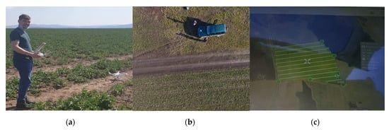
Figure 1.
The areal monitoring of crops: (a) the DJI Phantom 4 drone; (b) image captured by the drone; (c) flight layout.
The operational plan for digitalizing the surfaces sown with rapeseed comprised the following:
- Obtaining permission from the Aeronautic Authority and the Ministry of Defense to overfly at a 100 m altitude a 150 ha area, mentioning takeoff and landing spots;
- Establishing the drone’s flight layouts in the Pix4D application, in view of covering the area of interest. Then, the calculation algorithms generated flight trajectories that the drone had to cover at a 100 m altitude (an altitude determined by the existence of telecommunication antennas higher than 50 m within this zone) so that the pictures taken had a 70% overlap and the flight times were sustained by battery power (around 25 min for a battery);
- Preparing the drone for takeoff required the following flight conditions to be met: favorable weather conditions, with clear skies and wind speeds under 7 m/s, coverage of telecommunication network necessary for data transmission, and adequate GPS signal;
- Close monitoring of the trajectories, flight parameters, and drone positioning at each moment so that, in cases of any dysfunction, action can be taken immediately (immediate return to takeoff position command, engine shutdown, and forced landing in case of imminent danger, avoiding flying over groups of people, or in the proximity of aircraft or vehicles).
Multispectral cameras are used in agriculture. In our case, a Micasense camera was used. Gathering these data is performed according to a rule used in generating ortho-photograms, meaning that it is necessary for the pictures to overlap (sidelap and overlap of minimum 70%). Another significant aspect is the desired resolution: If one flies at a height of 50 m, the resolution will be 5 cm/px. If one flies at a hight of 100 m, the resolution will be 10 cm/px. Moreover, a lower altitude flight means a larger number of routes due to the coverage angle of the sensor, which implicitly means longer flight times. In conclusion, the resolution obtained from a height of 100 m was sufficient for our test. From a legal point of view, at the moment, flying drones is only permitted up to 120 m according to the Open Drone category.
Flights took place at a 100 m altitude according to a flight plan determined by selecting an area of the terrain on Google Earth or Map support (Figure 1c).
3. Results and Discussion
The impact of information obtained by software processing images taken by drones is positive on the farm. Furthermore, it contributes to the early diagnosis of the negative impact certain stressors (diseases, pests, weeds, etc.) have on crops. An incorrect diagnosis can lead to inappropriate management decisions, such as the selection of the incorrect chemical applications, which could lead to a further decrease in crop health and yield or an increase in the intensity of the action of stressors [31].
In relation to flight altitude, the time interval between the photograph and the distances between drone routes is automatically calculated in view of their adequate overlapping, and a relevant orthophoto layout is obtained, such as the one in Figure 2a, which is obtained in the aftermath of the aerial monitoring of corn crops. Since the orthophotograph is a georeferenced image, the use of drones has led to favoring GIS mappings of each plot of the agricultural land. This allowed georeferencing agricultural plots and the correspondence with reality in the field using the GIS software pmx_Agroland, which works in tandem with the Agronavia software. Thus, specific data about each agricultural plot (i.e., coordinates, crops, rotation, crop rotation, allocated inputs, technological links, production, etc.) have been recorded and stored in order to be managed and scientifically analyzed. The data analysis findings contributed to an increase in knowledge, supporting the decision-making process in analyzing the ramifications of various decision-making options and selecting the most appropriate. As a result, there was an increase in productivity, a decrease in expenses, a speedy evaluation of work quality (Figure 2b), detection of damage (Figure 2c), and effective crop management at the farm level all while reducing the time needed for physical field visits [32].
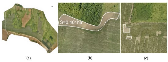
Figure 2.
The results of flights undertaken by drone: (a) orthophoto layout; (b) surfaces affected by agrophytotechnical factors; (c) surfaces affected by excessive pasturing.
By processing the images captured with the help of infrared cameras by using spectral filtering programs (Qgis and Open Drone Map), the nominal differences in the vegetation index were obtained (NDVI). Monitoring differences in NDVI leads to the adoption of critical first-stage solutions regarding the vegetation state of agricultural crops.
Monitoring rapeseed-growing plots indicated significant areas that are damaged due to excessive grazing from animals or their protracted stationing in the agricultural plot. The impact of this form of monitoring was positive because it provided solid arguments in support of management’s decision to intervene quickly in order to recover the damage, calculate the damage quickly, and provide an overview (Figure 3), as well as the immediate commencement of legal proceedings to protect and ensure the sustainability of the farm’s heritage. Drones are useful for detecting damage since they do not cause further harm and enable the rapid and precise estimation of the proportion of the damaged region.
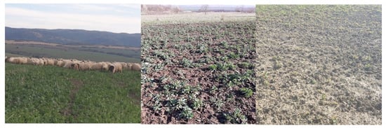
Figure 3.
Overall images of rapeseed crops affected by excessive pasturing.
Moreover, when returning from a mission, due to a command or reaching the minimum acceptable battery power (15 percent), landing occurs automatically on the shortest route, followed by battery replacement, take-off, and the resumption of the mission by repositioning on the route established in the flight schedule. However, the drone will resume recording aerial photographs from the point of interruption (Figure 4). Figure 4 indicates that the drone traveled 954 × 700 m in 15 min, covering 66 hectares at a height of 100 m with communication with 14 satellites. Ground Sampling Distance (GSD), which is the size of a pixel at ground level, is used: in this example, 4.38 cm determines the accuracy (resolution) of the photographs.
Figure 4.
Competing the mission and automatic landing.
After completing this stage, all aerial photographs of generated missions were downloaded and we began to process them with the dedicated Pix4D Mapper software. Mention should be made of the fact that each aerial photograph had the GPS position attached at the location where it was taken so that, upon uploading them to the dedicated software, the inventory of each photograph can be monitored. The first result was the cloud of dots created by the multitude of registered pixels, which define the nature of the surfaces and the photographed terrain’s shape. Thus, all preconditions are generated to obtain an orthophoto layout and a model of the relief.
To determine the extent of the damage and the vegetation state of the rapeseed crop, we agreed to obtain an orthophoto layout in *.tiff and/or *.ecw format, which should be opened by means of the AutoCad Map app, to conduct some measurements that are necessary for determining the resulting damage (Figure 5).
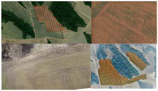
Figure 5.
Obtaining the orthophoto layout.
Thus, we have determined an overall damaged area of 92 ha, with an average plant density of 24 plants/square meter, compared to the normal one of around 50 plants/square meter that is comparatively taken from the nearest rotation, which suggests a damage percentage of around 48%. The density of plants was calculated using the method of squares with a side of 1 m (a method also used by insurance companies), because it is used in ecology to estimate the absolute density of organisms per unit area [33] and other studies [34].
We wish this case study to be perceived as a modern, innovative, and sustainable procedure that farmers may use to obtain precise, mathematical answers regarding the degree of crop development based on objective analyses performed on the basis of scientific algorithms for gathering and processing digital information.
The use of drones on the farm for the aerial surveillance of agricultural crops and precision technology has resulted in better decision making by increasing the awareness of identified problems and the precise monitoring of influencing factors. As a result, two integrated logic schemes were developed: one that digitizes each agricultural plot and allows the download of forms useful for state institutions (Figure 6) and another that records and manages the inputs for each agricultural plot in order to optimize them and allows the download of forms useful for interacting with state institutions (Figure 7). This resulted in a growth in farm operations, which began with a retrospective technical-economic analysis at the plot level and considering the suggested crop structure and the promotion of crops unique to the concept of sustainable agriculture. In addition, the farm’s management uses data collected from drones and predictive analyses to gain knowledge about the enterprise’s future possibilities by suggesting feasible alternatives. The study reveals that early and precise diagnosis is critical in reducing losses caused by various stressors (diseases, pests, weeds, and so on), and drones play a vital role in gathering real-time information about the state of the crops. As a result, the intervention is quick, efficient, and successful uet o the precision technology of the farm’s equipment. Agricultural crop aerial monitoring, in combination with other precision agriculture vectors, has frequently assisted enterprise management in improving technology (i.e., the use of amendments every two years, the establishment of technological lines, and the dynamic tracking of inputs allocated to each plot and their impact on production according to logical schemes).
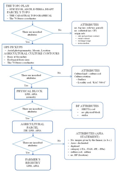
Figure 6.
Logical scheme subvention module.
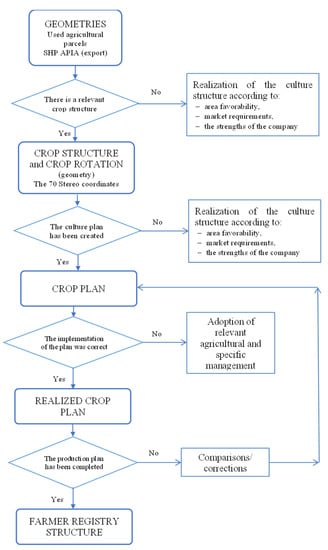
Figure 7.
Logical scheme farmer’s register module.
The results of this study urge us to continue research and develop solutions that allow the interpretation and use of information from multiple sources using information and communication technology and result in the combination of GIS potential with the usefulness of the Internet and the creation of a WebGIS platform [35].
4. Conclusions
The present research highlights the relevance of the aerial monitoring of agricultural crops in the following directions: the identification of the vegetation status of agricultural crops and the identification of changes and vulnerabilities in the agroecosystem, which in our case involved the damage caused by abusive grazing (common practice and insufficiently combated for lack of arguments relevant).
Across time and space, climate change has always played a central role in agriculture. A favorable response to these challenges may be identified by making use of the services offered by information and communication technology (ITC), the Internet of Things, and UAVs associated with image data analysis.
The research highlights the usefulness of implementing the aerial monitoring system of agricultural crops through the rapidity of obtaining images (4 h/100 ha) and the processing and interpretation of results (24 h) in order to implement solutions. Damage assessment must also be carried out within a few days of production, which by other means was very difficult to achieve and was even impossible in the case of large areas.
For further developments, we will attempt to identify new elements and elaborate technologies that use multispectral images, the analyzed and interpreted infrastructure, and specialist experience and equipment precision.
Author Contributions
Conceptualization, R.I.; Data curation, P.P.; Methodology, R.I. and A.Ș.; Project administration, P.I.; Writing—review & editing, A.Ș. All authors have read and agreed to the published version of the manuscript.
Funding
This research received no external funding.
Institutional Review Board Statement
Not applicable.
Informed Consent Statement
Not applicable.
Data Availability Statement
Not applicable.
Acknowledgments
This paper was supported by the Research Center for Agricultural Sciences and Environmental Protection from the “Lucian Blaga” University of Sibiu.
Conflicts of Interest
The authors declare no conflict of interest.
References
- Hayat, S.; Yanmaz, E.; Muzaffar, R. Survey on Unmanned Aerial Vehicle Networks for Civil Applications: A Communications Viewpoint. IEEE Commun. Surv. Tutor. 2016, 18, 2624–2661. [Google Scholar] [CrossRef]
- Ayamga, M.; Akaba, S.; Nyaaba, A.A. Multifaceted applicability of drones: A review. Technol. Forecast. Soc. Chang. 2021, 167, 120677. [Google Scholar] [CrossRef]
- Huang, Y.; Thomson, S.J.; Hoffmann, W.C.; Lan, V.; Fritz, B.K. Development and prospect of unmanned aerial vehicle technologies for agricultural production management. Int. J. Agricult. Biol. Eng. 2013, 6, 1–10. [Google Scholar]
- Muchiri, N.; Kimathi, S. A review of applications and potential applications of UAV. Proc. Sustain. Res. Innov. Conf. 2016, 280–283. [Google Scholar] [CrossRef]
- Sullivan, D.G.; Fulton, J.P.; Shaw, J.N.; Bland, G. Evaluating the Sensitivity of an Unmanned Thermal Infrared Aerial System to Detect Water Stress in a Cotton Canopy. Trans. ASABE 2007, 50, 1963–1969. [Google Scholar] [CrossRef] [Green Version]
- Delgado-Vera, C.; Aguirre-Munizaga, M.; Jiménez-Icaza, M.; Manobanda-Herrera, N.; Rodríguez-Méndez, A. A Photogrammetry Software as a Tool for Precision Agriculture: A Case Study. In Communications in Computer and Information Science; Valencia-García, R., Lagos-Ortiz, K., Alcaraz-Mármol, G., Del Cioppo, J., Vera-Lucio, N., Bucaram-Leverone, M., Eds.; Springer: Cham, Switzerland, 2017; Volume 749. [Google Scholar] [CrossRef]
- Iagăru, P.; Pavel, P.; Iagăru, R. Implementation of the concept Agriculture of Precision a way to improve the Management of Agricultural Enterprises. Sci. Pap. Ser. Manag. Econ. Eng. Agric. Rural. Dev. 2019, 19, 229–233. [Google Scholar]
- Khan, N.; Ray, R.; Sargani, G.; Ihtisham, M.; Khayyam, M.; Ismail, S. Current Progress and Future Prospects of Agriculture Technology: Gateway to Sustainable Agriculture. Sustainability 2021, 13, 4883. [Google Scholar] [CrossRef]
- Fertu, C.; Dobrota, L.M.; Balasan, D.L.; Stanciu, S. Monitoring the vegetation of agricultural crops using drones and remote sensing-comparative presentation. Sci. Pap. Manag. Econ. Eng. Agric. Rural. Dev. 2021, 21, 249–254. [Google Scholar]
- Mihalache, D.; Vanghele, N.; Petre, A.; Matache, A. The use of drones in modern agriculture. Ann. Univ. Craiova-Agric. Montanology Cadastre Ser. 2021, 50, 349–354. [Google Scholar]
- Sylvester, G. E-Agriculture in Action: Drones for Agriculture; Food and Agriculture Organization of the United Nations And International Telecommunication Union: Bangkok, Thailand, 2018. [Google Scholar]
- Rhoads, F.M.; Yonts, C.D. Irrigation Scheduling for Corn: Why and How. In The National Corn Handbook (NCH); University of Wisconson: Madison, WI, USA, 2000; Available online: http://corn.agronomy.wisc.edu/Management/NCH.aspx (accessed on 17 April 2022).
- Calderón, R.; Navas-Cortés, J.A.; Lucena, C.; Zarco-Tejada, P.J. High-resolution airborne hyperspectral and thermal imagery for early detection of Verticillium wilt of olive using fluorescence, temperature and narrow-band spectral indices. Remote Sens. Environ. 2013, 139, 231–245. [Google Scholar] [CrossRef]
- Wang, D.-C.; Zhang, G.-L.; Pan, X.-Z.; Zhao, Y.-G.; Zhao, M.-S.; Wang, G.-F. Mapping Soil Texture of a Plain Area Using Fuzzy-c-Means Clustering Method Based on Land Surface Diurnal Temperature Difference. Pedosphere 2012, 22, 394–403. [Google Scholar] [CrossRef]
- Wang, D.-C.; Zhang, G.-L.; Zhao, M.-S.; Pan, X.; Zhao, Y.-G.; Li, D.-C.; Macmillan, B. Retrieval and Mapping of Soil Texture Based on Land Surface Diurnal Temperature Range Data from MODIS. PLoS ONE 2015, 10, e0129977. [Google Scholar] [CrossRef] [PubMed]
- Sullivan, D.G.; Shaw, J.N.; Mask, P.L.; Rickman, D.; Guertal, E.A.; Luvall, J.; Wersinger, J.M. Evaluation of Multispectral Data for Rapid Assessment of Wheat Straw Residue Cover. Soil Sci. Soc. Am. J. 2004, 68, 2007–2013. [Google Scholar] [CrossRef]
- Jensen, T.; Apan, A.; Zeller, L. Crop maturity mapping using a lowcost low-altitude remote sensing system. In Proceedings of the 2009 Surveying and Spatial Sciences Institute Biennial International Conference (SSC 2009), Adelaide, Australia, 28 September–2 October 2009. [Google Scholar]
- Tiwari, A.; Dixit, A. Unmanned aerial vehicle and geospatial technology pushing the limits of development. Am. J. Eng. Res. 2015, 4, 16–21. [Google Scholar]
- Swain, K.C.; Thomson, S.J.; Jayasuriya, H. Adoption of an Unmanned Helicopter for Low-Altitude Remote Sensing to Estimate Yield and Total Biomass of a Rice Crop. Trans. ASABE 2010, 53, 21–27. [Google Scholar] [CrossRef] [Green Version]
- Geipel, J.; Link, J.; Claupein, W. Combined Spectral and Spatial Modeling of Corn Yield Based on Aerial Images and Crop Surface Models Acquired with an Unmanned Aircraft System. Remote Sens. 2014, 6, 10335. [Google Scholar] [CrossRef] [Green Version]
- Sankaran, S.; Khot, L.R.; Espinoza, C.Z.; Jarolmasjed, S.; Sathuvalli, V.R.; VanDeMark, G.J.; Miklas, P.N.; Carter, A.H.; Pumphrey, M.O.; Knowles, N.R.; et al. Low-altitude, high-resolution aerial imaging systems for row and field crop phenotyping: A review. Eur. J. Agron. 2015, 70, 112–123. [Google Scholar] [CrossRef]
- Khanal, S.; Fulton, J.; Shearer, S. An overview of current and potential applications of thermal remote sensing in precision agriculture. Comput. Electron. Agric. 2017, 139, 22–32. [Google Scholar] [CrossRef]
- Anderson, K.; Gaston, K.J. Lightweight unmanned aerial vehicles will revolutionize spatial ecology. Front. Ecol. Environ. 2013, 11, 138–146. [Google Scholar] [CrossRef] [Green Version]
- Garcia-Ruiz, F.; Sankaran, S.; Maja, J.M.; Lee, W.S.; Rasmussen, J.; Ehsani, R. Comparison of two aerial imaging platforms for identification of Huanglongbing-infected citrus trees. Comput. Electron. Agric. 2013, 91, 106–115. [Google Scholar] [CrossRef]
- Jensen, T.; Apan, A.; Young, F.R.; Zeller, L.C.; Cleminson, V. Assessing grain crop attributes using digital imagery acquired from a low-altitude remote controlled aircraft. In Proceedings of the 2003 Spatial Sciences Institute Conference: Spatial Knowledge Without Boundaries (SSC2003), Canberra, Australia, 22–27 September 2003; Spatial Sciences Institute: Los Angeles, CA, USA, 2003; pp. 1–11. [Google Scholar]
- Csajbók, J.; Buday-Bódi, E.; Nagy, A.; Fehér, Z.Z.; Tamás, A.; Virág, I.C.; Bojtor, C.; Forgács, F.; Vad, A.M.; Kutasy, E. Multispectral Analysis of Small Plots Based on Field and Remote Sensing Surveys—A Comparative Evaluation. Sustainability 2022, 14, 3339. [Google Scholar] [CrossRef]
- Almalki, F.; Soufiene, B.; Alsamhi, S.; Sakli, H. A Low-Cost Platform for Environmental Smart Farming Monitoring System Based on IoT and UAVs. Sustainability 2021, 13, 5908. [Google Scholar] [CrossRef]
- Saunders, M.; Lewis, P.; Thornhill, A. Research methods for business students; Pearson: Harlow, UK; Munich, Germany, 2016. [Google Scholar]
- Iagăru, P.; Mărcuță, L.; Iagăru, R.; Mărcuță, A. Sustainable resource management, the source of production integration, biodiversity conservation and socio-cultural values in grasway ecosystems. Rom. Biotechnol. Lett. 2020, 25, 1948–1991. [Google Scholar] [CrossRef]
- Olteanu, G.; Puiu, I.; Bekö, A.; Ghinea, A. Agricultura de Precizie—O Cale Pentru Eficientizarea Producției de Cartof, Sesiunea de Comunicări Științifice “45 de ani de Cercetare-Dezvoltare: Tradiție, Continuitate și Viitor Pentru Agricultura României”; Institutul Național de Cercetare Dezvoltare pentru Cartof și Sfeclă de Zahăr din Brașov: Brașov, Romania, 2012. [Google Scholar]
- Abdulridha, J.; Ampatzidis, Y.; Kakarla, S.C.; Roberts, P. Detection of target spot and bacterial spot diseases in tomato using UAV-based and benchtop-based hyperspectral imaging techniques. Precis. Agric. 2019, 21, 955–978. [Google Scholar] [CrossRef]
- Ayamga, M.; Tekinerdogan, B.; Kassahun, A. Exploring the challenges posed by regulations for the use of drones in agricul-ture in the African context. Land 2021, 10, 164. [Google Scholar] [CrossRef]
- Battes, K. Ecologie Generală: Ghid de Lucrări Practice; Presa Universitară Clujeană: Cluj-Napoca, Romania, 2012; Volume 46. [Google Scholar]
- García-Martínez, H.; Flores-Magdaleno, H.; Ascencio-Hernández, R.; Khalil-Gardezi, A.; Tijerina-Chávez, L.; Mancilla-Villa, O.; Vázquez-Peña, M. Corn Grain Yield Estimation from Vegetation Indices, Canopy Cover, Plant Density, and a Neural Network Using Multispectral and RGB Images Acquired with Unmanned Aerial Vehicles. Agriculture 2020, 10, 277. [Google Scholar] [CrossRef]
- Randazzo, G.; Italiano, F.; Micallef, A.; Tomasello, A.; Cassetti, F.P.; Zammit, A.; D’Amico, S.; Saliba, O.; Cascio, M.; Cavallaro, F.; et al. WebGIS Implementation for Dynamic Mapping and Visualization of Coastal Geospatial Data: A Case Study of BESS Project. Appl. Sci. 2021, 11, 8233. [Google Scholar] [CrossRef]
Publisher’s Note: MDPI stays neutral with regard to jurisdictional claims in published maps and institutional affiliations. |
© 2022 by the authors. Licensee MDPI, Basel, Switzerland. This article is an open access article distributed under the terms and conditions of the Creative Commons Attribution (CC BY) license (https://creativecommons.org/licenses/by/4.0/).