Article

Using WaTEM/SEDEM to Model the Effects of Crop Rotation and Changes in Land Use on Sediment Transport in the Vrchlice Watershed

Department of Landscape Water Conservation, Faculty of Civil Engineering, Czech Technical University in Prague, 16629 Prague, Czech Republic
*
Author to whom correspondence should be addressed.
Sustainability 2022, 14(10), 5748; https://doi.org/10.3390/su14105748
Submission received: 24 February 2022 / Revised: 27 April 2022 / Accepted: 8 May 2022 / Published: 10 May 2022

Abstract

:
The Czech landscape has undergone various changes over the last 100 years and has been mainly adapted agriculturally for economic purposes. This has resulted, among other things, in reservoirs being clogged with sediment. The Vrchlice Reservoir was built in 1970 to supply drinking water for around 50,000 inhabitants, and increased sedimentation has been detected in the reservoir in recent years. Water erosion and sediment transport were modeled with WaTEM/SEDEM. Sediment volumes were measured in eight ponds across the watershed for calibration purposes. Modeled results from ponds in watersheds covered mostly with arable lands generally corresponded with the measured values. Although in forested watersheds, the measured sediment volumes greatly exceeded modeled sediment yields, indicating high uncertainty in using USLE-based models in non-agricultural watersheds. The modeled scenarios represented pre-Communist, Communist, and post-Communist eras. For these periods WaTEM/SEDEM was used to evaluate three isolated effects: the effects of various crops on arable lands, the effects of farmland fragmentation, and finally the effects of changes in land use. The change in crops proved to be an important factor causing high siltation rate (potential 23% reduction in sediment yield for historical periods), and land fragmentation played the second important role (potential 15% reduction in sediment yield can be reached by land fragmentation). Across all scenarios, the lowest sediment yield and reservoirs siltation rates were obtained from the pre-Communist and Communist crop share under current land use conditions, and current land use with farmland fragmentation implemented, as it was re-constructed for the pre-Communist era. This supports the idea that the introduction of green areas within arable lands are beneficial to the landscape and can help reduce soil erosion and reservoir siltation.

1. Introduction

Almost 95% of Czechs are supplied with drinking water from public networks, and more than half of this water comes from surface sources. The water quality of surface bodies depends on the landscape processes. The Czech landscape has been gradually transformed to aid economic development: farmlands that were originally fragmented into small fields were adapted into large monotonous fields during Communist agriculture intensification efforts in the 1950s, but there has been a slight extensification in the modern, post-Communist era (since 1989) [1,2]. Aside from the changes in farmland structure, crop rotation developed over the course of time as well [1]. Many ponds were built during the medieval ages but were turned into arable lands at the beginning of the nineteenth century. The increasing demand for drinking water resulted in the construction of large reservoirs in the twentieth century. In modern days, ponds are largely being built or restored [3]. Babek et al. [4] refers to ponds as archives of sediments that may lose their storage capacity and area due to siltation over a relatively short time. This confirms that water erosion has an impact, not only on soil quality in the fields, but also on large reservoirs as well as on small ponds, where eutrophication occurs. According to Sladeckova and Zacek [5], eutrophication in reservoirs is the most frequent cause of problems in water treatment and supply. Eutrophication is usually indicative of macroalgal blooms, hypoxia, and decreased water clarity [6]. Additionally, sediment removal introduces economic and legislative complications. According to the Czech legislation, removed sediments are considered waste and can only be returned to the fields under special conditions [7,8]. The expenses of sediment removal include the removal, transportation, storage, and numerous laboratory tests of the sediment samples. Various hazardous or toxic substances can be present in the sediment due to anthropogenic interventions in the landscape, including toxic metals, organic pollutants, pharmaceuticals, etc. The volume of sediment in Czech ponds is estimated to be 200 million m3 across 24,000 fishponds [9]. Baxa et al. [9] presented a study wherein 200 samples of sediment from Czech fishponds were analyzed for their toxic metal content, and the concentrations of toxic metals found in these sediment samples were higher than the concentrations found in local animals, plants, and water.
The Vrchlice reservoir was built in 1970 as a source of drinking water. It holds 7.9 million m3 of water for more than 50,000 inhabitants of the surrounding area [10]. However, it was identified as “relatively risky” in terms of sediment deposition, as it is located in an area dominated by agricultural use. The total amount of sediment in the Vrchlice reservoir, estimated to be between 125,000 and 140,000 m3, was measured by Krása et al. [11]. It was, therefore, deemed necessary to search for the sources of the sediment across the watershed and to also consider the history of the Vrchlice watershed. WaTEM/SEDEM (Water and Tillage Erosion Model/Sediment Delivery Model) was selected to model the production, transport, and deposition of sediment in this watershed. This spatially distributed model is based on RUSLE—Revised Universal Soil Loss Equation [12,13,14] and can be used for large scale modelling. For assessment of the effects of crop share changes in soil loss, mostly only RUSLE could be used [15], but then, we would not be able to provide the comparison with the other effects (land use change and land fragmentation change) on neither soil loss nor the sediment yield. So, to provide the same complexity and comparability of the results, we decided to use WaTEM/SEDEM in order to benefit from a spatially distributed approach to sediment routing that allowed us to also assess the land fragmentation changes [16,17,18].
Krása et al. [11] used WaTEM/SEDEM to model the amount of sediment in the Vrchlice reservoir and their results corresponded sufficiently to the measured value. Another study conducted by Van Rompaey et al. [19] suggested that the spatial pattern of land cover change is more important than the percentage of land cover change.
In this study, various scenarios concerning land use changes and crop rotation changes across the Vrchlice watershed were incorporated into WaTEM/SEDEM, to answer the following research questions: (1) What is the optimal setting of calibration parameters of the WaTEM/SEDEM model in the Vrchlice reservoir watershed and how do the results from the model correspond with measured values? (2) What are the effects of varying crop rotations, farmland fragmentation, and changes in land use on sediment production, transport, and deposition in the watershed? (3) Among the effects, which are the most favorable scenarios in terms of sediment yield and deposition in ponds?
The aim of the study is to verify the hypothesis that the high sedimentation rate in reservoirs in agricultural watersheds may be caused by parallel changes in land structure, land use and crops used across recent periods, and that reversing some of these changes in an agricultural landscape could help to reduce the negative impacts of erosion by water on reservoirs.

2. Materials and Methods

2.1. Study Watershed

The Vrchlice reservoir watershed (Figure 1) with an area of approximately 97 km2 is located in the central Bohemia region of the Czech Republic. This region is characterized as moderately warm and moderately humid. The average annual temperature of the region is 7–8 °C, and the mean annual rainfall is 550–650 mm [20]. The highest point of the watershed is 555 m above sea level, and the lowest point—the Vrchlice reservoir outlet—is 308 m above sea level. The bedrock is strongly metamorphic, with low porosity, and there is, therefore, little groundwater interaction. The abundance of the groundwater springs fluctuates, and the streams can run dry during periods of drought [21]. The reservoir was built in 1970 to provide drinking water for the nearby town of Kutna Hora. When the reservoir was constructed, Hamersky pond was restored to protect the reservoir from high sediment inflow, and the Pilsky pond dam was preserved at the bottom of the reservoir to trap sediment particles before they reached the water withdrawal [10]. Currently, 145 ponds exist in the watershed. The average annual flow rate in the Vrchlice reservoir is 0.439 m3/s [11]. Over one half of the area of the watershed is covered with arable lands. The main crops are wheat, rapeseed, corn, and barley. The average field size is 12.7 ha.

2.2. WaTEM/SEDEM Model Description

The WaTEM/SEDEM model is a spatially distributed sediment delivery model based on RUSLE. The model calculates the amount of sediment that is exported towards a body of surface water. The deposition in the model is controlled by a transport capacity that is calculated for each pixel. It uses raster maps in Idrisi format, parameters, and tables to calculate the production and distribution of sediment across the watershed [12,13,14]. According to Krása et al. [7], the WaTEM/SEDEM model has been verified and is applicable to large-scale studies in the Czech Republic. The results from the model represent long-term yearly averages of sediment production, transport, and deposition across the whole watershed. The total sediment production is the amount of soil loss in the watershed. A portion of this production is re-deposited in the fields. The rest, i.e., the total sediment yield, is transported to rivers and ponds. The amount deposited in ponds is the total pond deposition, and the part of the sediment transported to rivers is the total sediment export. The remaining amount of sediment is exported from the watershed at the outlet, i.e., the total river export. The model calculates the annual average sediment input in each river section, and the sediment input/deposition into each pond. Raster maps of soil loss and sediment inflow/outflow are produced with the resolution of the input data [22].

2.3. Input Data

Input data for the current, post-Communist era, were prepared. Some of the input data were additionally edited for scenario modeling purposes (See Section 2.5). The DEM (Digital Elevation Model) was obtained from DMR4G (the fourth generation of the digital relief model of the Czech Republic; provided by State Administration of Land Surveying and Cadastre) [23], with 5 m spatial resolution. The parcel map was developed from a land use map, which was obtained from ZABAGED (Fundamental Base of Geographic Data of the Czech Republic; it was provided by State Administration of Land Surveying and Cadastre) [24] and was corrected by LPIS (Land Parcel Identification System; provided by the Czech Ministry of Agriculture) [25], and manually edited over the current Orthophoto of the Czech Republic (provided by State Administration of Land Surveying and Cadastre) [26]. Methodology originally developed by Vopravil et al. [27] was used to obtain a map of the K factor (soil erodibility factor). A map of BPEJ (soil–climatic units, provided by The State Land Office of the Czech Republic) was converted, based on HPJ code (main soil unit code) [28]. Only small missing areas of grasslands and arable lands had to be filled, using simple interpolation. The R factor (rainfall erosivity factor) was defined as 0.0686 (M*mm*m−2*h−1), previously calculated by Krása et al. [29] for the calibration period. The R factor was not modified for the historical scenarios, since our study is not focused on climate change, but only the effects of watershed management on potential changes in sediment delivery. Methodology outlined by Wischmeier et al. [30] was used to determine the average C factor (crop erosivity factor). The crop-cover percentages for year 2021 (Table 1) were provided by a local farm manager. The data covered an area of 1910 ha of a total 5300 ha of farmland in the watershed. The average C factor was defined as 0.267 for crops, 0.005 for grasslands, 0.015 for gardens, and 0.15 for brush. The equations by McCool et al. [31] were selected for the LS Factor (topographical factor). A detailed description of the model parameters can be found in the WaTEM/SEDEM manual provided by a K.U. Leuven Research Group [32]. The value of trap efficiency (TE), ranging from 0% to 100%, had to be determined for each of the 145 ponds. This value represents the percentage of trapped sediment from the total sediment input. For hydrologically significant ponds (area > 0.5 ha), the Brune Curve Method [33] was conducted, using the volume and the discharge of the pond. The volumes were either taken from a previous study [34] or were determined by field surveys. In this case, the water depth was measured at the dam, and the result was multiplied by 1/3 of the water area. The discharge was recalculated according to the area of the sub-basin of the pond, using discharge data from the previous study by Sykora et al. [34]. The TE ranged from 10% to 96% (40 cases). For small hydrologically significant ponds (area < 0.5 ha), TE = 50% (33 cases), because no parameters were available to determine their volumes. Sensitivity analysis was conducted, subsequently proving that there was no direct effect on the results. For ponds that were not connected to the stream network, TE = 100% (66 cases). Ponds that were located on a secondary channel were removed from the calculation for modeling purposes by setting TE = 0% (6 cases). Secondary channels are used for pond filling, and during erosion events the majority of sediment is transported by primary channels.

2.4. Calibration and Sensitivity Analysis

In this study, the model was calibrated for the current, post-Communist land use and crop rotation, using the sediment volume measured in eight ponds across the watershed. A simple method for measuring the sediment layer thickness and IDW (inverse distance weighted) interpolation was used to create an elevation model of the sediment layer. The total sediment volume—obtained from the elevation model—was divided by the years of ongoing deposition, i.e., the number of years since construction or since the last removal of sediment. This information was provided by local pond managers or by city mayors. For reservoirs on the Opatovicky stream, reservoir durations and original sediment thicknesses in the reconstructed reservoirs were hard to obtain, and these reservoirs were not located in agricultural watersheds for where the model is intended to be used [17], therefore these reservoirs could not be used for calibration. The mass density of the sediment was assumed to be 1.25 tons per cubic meter, according to the study by Dostal et al. [35]. Three ponds in agricultural areas were selected for calibration: Hamersky, Steklik, and Navesky (for their location see Section 3.1). Their long-term year average depositions estimated from measurements were added together, and the sum of the deposition was used as a reference to the modeled value. Calibration was performed for the transport capacity (KTC) parameter, and sensitivity analyzes were conducted for the parcel trap efficiency (PTEF) and parcel connectivity (PC) parameters. During the sensitivity analysis, the PTEF was modified and ranged from 0 to 100, the PC was modified from 0 to 100 according to previous studies in the Czech Republic [7,11,36].

2.5. The Effects of Crop Rotation, Farmland Fragmentation, and Changes in Land Use

The effects of varying crop rotation, farmland fragmentation, and changes in land use on sediment production, transport, and deposition were analyzed by incorporating different scenarios into the WaTEM/SEDEM model. The effects of crop rotation are simulated by implementing varying C factor for specific crops, farmland fragmentation is incorporated by implementing two scenarios: with and without farmland fragmentation, and changes in land use by using various parcel maps. The scenarios were run in isolation. The scenarios represented pre-Communist era, Communist era, and post-Communist era. An overview of the scenarios is in Table 2.

2.5.1. The Effects of Crop Rotation

Three scenarios were run to analyze the effects of historical crop rotations in combination with post-Communist land use cover. The average C factor for crops was determined for each period, based on the typical crop shares, using a methodology outlined by Vopravil et al. [27]. Typical historical crop cover percentages in the Czech Republic were provided by the Czech Statistical Office [37] and were assumed to be representative for crop rotations during the periods [38]. During the pre-Communist era, the dominant crops were rye, oats, and potatoes. During the Communist era, the dominant crops were spring barley and winter wheat. In the post-Communist era, winter wheat, rapeseed, and corn were dominant (Table 3). The average C factor was determined as follows: 0.196 for the pre-Communist era, 0.163 for the Communist era, and 0.267 for the post-Communist era. The C factor for crops was the only varying input parameter, in order to isolate the effects of crop cover percentage.

2.5.2. The Effect of Farmland Fragmentation

Two scenarios were run to analyze the effect of farmland fragmentation, which was typical in the Czech Republic before and at the beginning of the Communist era. These areas can be seen from historical maps or historical aerial photographs, which means that a lot of manual editing would have to be undertaken, in order to map these grassed areas in between farmlands across the whole watershed. Therefore, a detailed map of one sub-basin was created, based on a 1938 historical aerial photograph (Figure 2a). The sub-basin is located in the south-eastern part of the watershed, and with a size of 24.34 km2 the sub-basin covers one quarter of the total Vrchlice watershed area. The reintroduced grasslands in this sub-basin covered 2.77 km2 (17%) of a total 16.62 km2 of farmland area. Another map without farmland fragmentation was created (Figure 2b). Both land use maps were incorporated into the model, with corresponding C factor maps (0.267 for crops, 0.005 for grass). The effect of parcel borders was included in the parcel connectivity parameter. It was assumed that there was no trapping at the borders of two crop fields. The results from both scenarios were compared and the effect was later applied to pre-Communist and early Communist land use scenarios.

2.5.3. The Effects of Changes in Land Use

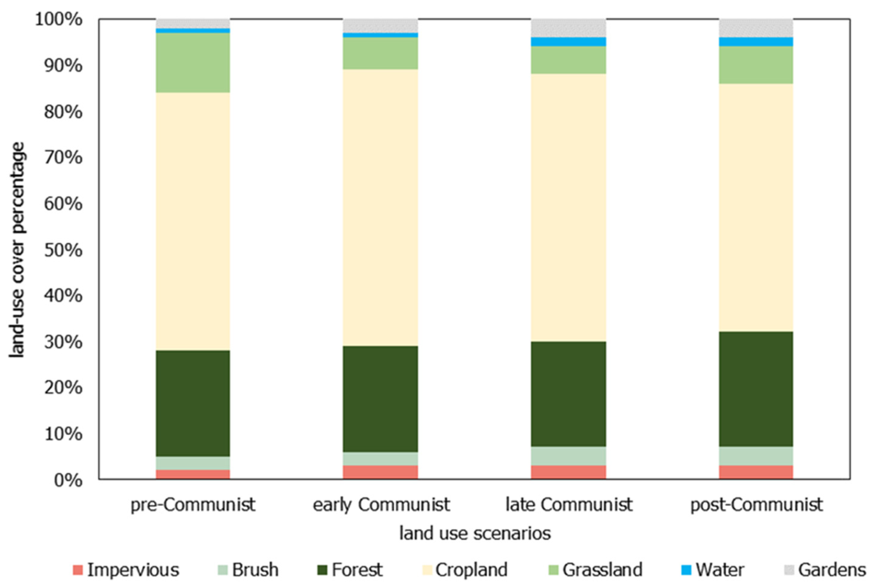
Four scenarios were run to analyze the effects of changes in land use, by incorporating varying parcel maps into the model. As presented in Figure 3, the changes in percentage of land use shares are negligible. However, the spatial land use changes across the watershed can affect the sediment transport processes. The varying land use maps were developed from the current land use map (See Section 2.3), by manually editing over historical map materials. The maps represent pre-Communist era (manually edited on the basis of the 2nd Military Survey from the nineteenth century), early Communist era (manually edited over historical aerial from 1954), late Communist era (manually edited over 1983 historical aerials) and current, post-Communist era. The parcel map, developed from these land use maps for modeling purposes, was the only varying input parameter in order to isolate the effect of changes in land use. The results obtained from the farmland fragmentation analysis had to be applied to the pre-Communist and the early Communist eras, in order to include the farmland fragmentation.

3. Results

3.1. Calibration and Sensitivity Analysis

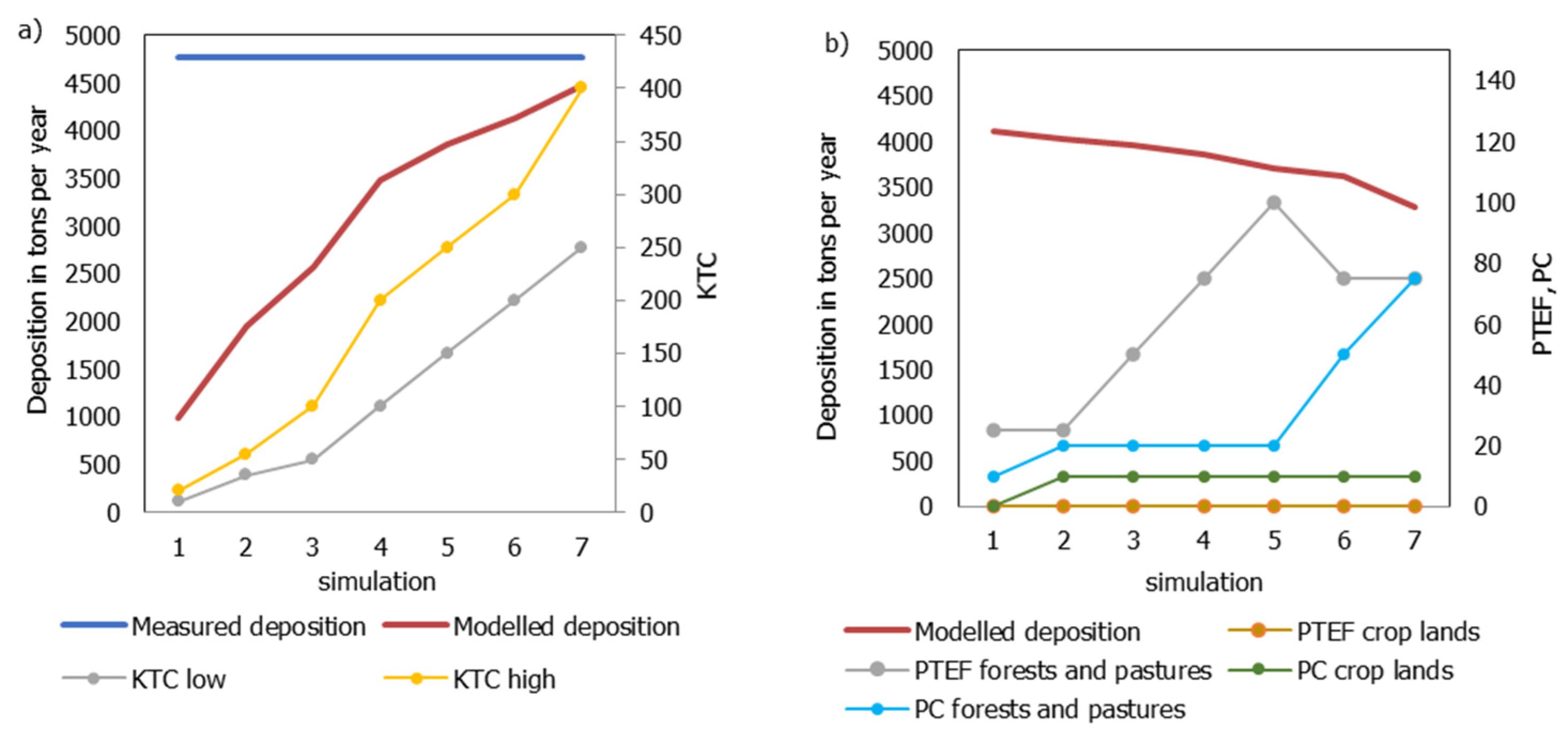
Calibration was performed for the transport capacity (KTC) parameter, and sensitivity analyses were conducted for both the parcel trap efficiency (PTEF) and the parcel connectivity (PC) parameters. Based on the calibration, the KTC values were adjusted to 150 = KTC LOW, and 250 = KTC HIGH (simulation 5 in Figure 4a). The sensitivity analyses showed that PTEF does not have a major effect on the results. However, when PC for forests and pastures increases, the modeled deposition starts to decrease (Figure 4b). Finally, PTEF was adjusted to recommended values of 0 = PTEF crop lands and 75 = PTEF forests and pastures, according to Krása [22]. PC was adjusted to 10 = PC crop lands, and 20 = PC forests and pastures, to slightly increase the modeled deposition value (simulation 4 in Figure 4b).
The parameters selected for the final model, run after calibration and sensitivity analysis (Table 4), correspond best to the major agricultural areas and the measured results for the Hamersky, Steklik, and Navesky ponds. In the case of Steklik the modeled value exceeds the measured volume, while for the other two ponds the modeled volume has not yet reached the measured volume (See Table 5). Further rises in the KTC values do not correspond with previous calibration attempts for larger datasets of reservoirs, and this would lead to calibration only on the basis of Hamersky pond, where the sediment volume measurement has uncertainties based on changes in the reservoir area over time. Hamersky pond was measured in 2002 and the annual sediment deposition between 1977 to 2002 was calculated to be only 1309 ton/year [11]. The second measurement in 2020 indicated a much higher siltation rate at 3825 ton/year. The WaTEM/SEDEM model data relies on long-term inputs, and the rainfall erosivity and C factor values are representative for approx. the last 30 years. Therefore, we did not take the measured value of Hamersky pond for the recent situation as a fully justified value comparable with model results.
Even for the selected calibration parameters, we did not reach the measured sediment values in any pond except the Steklik. Table 5 shows the modeled deposition versus the measured deposition. In the Hamersky, Steklik, and Navesky ponds, the modeled results correspond with the measured values at a difference of less than 30%. These ponds are outlets of basins mostly covered with farmlands. There are larger differences in the ponds on the Opatovicky stream (Jesterny, Pracny, Vackar, Novy Opatovicky, Mlynsky), where the model underestimates the supply of sediment to the reservoirs in comparison with the measured volumes by more than 85%. The siltation rates in these reservoirs are associated with the higher uncertainty, since the deposition time is not exactly defined. The discrepancies and uncertainties are explored further in the discussion section.
The map in Figure 5 presents the results for current land use and crop rotation. The map shows the average annual soil loss in fields, and the hillslope sediment input into corresponding river sections. Mean water erosion values < 0 are on fields with potential for soil loss, while values > 0 are on fields where sediment is potentially deposited.

3.2. The Effects of Crop Rotation, Farmland Fragmentation, and Changes in Land Use

The effects of crop rotation and changes in land use are presented as values for the whole watershed, and for deposition in following ponds: Vrchlice reservoir, Hamersky (1), Steklik (2), Navesky (3), Pilsky (located in the upper portion of the Vrchlice reservoir). Their location is shown in Figure 5.

3.2.1. The Effects of Crop Rotation

Among the varying crop rotation scenarios, the highest total sediment production occurs with the current, post-Communist era crop rotation. Based on the results in Table 6, the crop rotation from pre-Communist era reduced the total sediment production by 25%, and during the Communist era crop rotation, there is a reduction by 37%. The total amount of sediment transported to the rivers and ponds (the total sediment yield) is reduced by 15% with the pre-Communist era crop rotation, and by 23% with the Communist era crop rotation. The total river export is not greatly affected by the varying crop rotations.
The effect of crop rotation on sediment deposition in ponds is presented in Table 7. The deposition is reduced in the same proportion as the total sediment yield (Table 6). With the pre-Communist era crop rotation, the sediment deposition in ponds is reduced on an average by 15%, and with the Communist era crop rotation, the average reduction is by 23%.

3.2.2. The Effect of Farmland Fragmentation

An analysis of the farmland fragmentation effect showed that with farmland fragmentation, the total sediment production is reduced by 20%. The total amount of sediment transported to rivers and ponds, the total sediment yield, is reduced by 15% (Table 8). This reduction was then applied to the results in the analysis of changes in land use, specifically for the pre-Communist and early Communist era.

3.2.3. The Effects of Changes in Land Use

The lowest total sediment production occurred during the pre-Communist era land use scenario, with lower than 50,000 tons per year. The highest total sediment production occurred during the late Communist era land use scenario, with over 60,000 tons per year. In the post-Communist era land use, the sediment production was again slightly lower. The total amount of sediment transported into rivers and ponds (the total sediment yield) was lowest in the pre-Communist era land use scenario and highest in the late-Communist era land use scenario (Table 9). The pre-communist era land use reduced the total sediment production by 14%, but the total sediment yield by only 3%.
The total pond deposition was affected by the number of existing ponds in each land use scenario. There were 69 ponds in the pre-Communist land use scenario, in comparison with 94 ponds in the early Communist land use scenario. However, the total pond deposition was higher in the pre-Communist era land use scenario. The reason is that there were greater numbers of large and significant ponds in the pre-Communist era, and this increases the amount of sediment trapped in them. Many of the larger ponds were later decommissioned. As would be expected, even greater pond sediment deposition occurred with the late-Communist era and post-Communist era land-use scenarios, after the Vrchlice reservoir had been constructed and Hamersky pond had been restored. Likewise, the total river export was directly affected by the existence of ponds. The total river export value decreased greatly in the late-Communist era land use scenario, when due to the large volume of the Vrchlice reservoir and the low discharge of the Vrchlice river, there was enough time for the sediment particles to settle.
The effects of the different land use periods on sediment deposition in ponds is presented in Table 10. Navesky pond has the smallest basin, so the effect is great. Conversely, in ponds with larger basins (Hamersky and Steklik), the effect of different land uses is almost negligible. In case of Vrchlice, the effect is probably affected by a conversion of arable lands to grassland (0.9 km2 conversion). There is no other significant change in land use detected in the whole watershed. The pre-Communist era land use reduced the deposition in Hamersky pond by <2%, in Navesky by 72%.

3.3. A Comparison of All Effects

All scenarios are compared in Table 11 concerning the total sediment yield (the amount of sediment transported to rivers and ponds). The most favorable effects correspond to the scenarios with historical crop rotations. Another favorable scenario is the current, post-Communist land use in combination with farmland fragmentation.
The effects of all scenarios on sediment deposition in the Hamersky pond is presented in Table 12. Again, the most favorable results are associated with the historical crop rotations and farmland fragmentation implementation.

4. Discussion

The Vrchlice reservoir watershed was modeled using WaTEM/SEDEM. The best available high-resolution data were used. The calibration was based on sediment volumes that were measured in ponds across the watershed. The volumes were converted to the respective yearly average sediment deposition. Because the obtained sediment volumes were relatively large, measurement errors and evaluation errors could be neglected in the case of small ponds. However, in Hamersky pond, with an area of around 75,000 m2, errors could affect the calibration process; a measurement error of 5 cm in sediment layer thickness would mean an error of up to 260 tons per year (6.8%) in deposition. The Hamersky pond was also measured in 2002 and for the previous period it was estimated to have a much lower sedimentation rate [11]. Prosik pond is located above Hamersky pond. The trap efficiency of Prosik affects the deposition into Hamersky pond by hundreds of tons per year. However, data concerning the sediment deposition in Prosik were not available at the time of this study. Due to these unknown parameters related to Hamersky pond, it would not be appropriate to increase the KTC calibration parameters even more (simulation 6 and 7 in Figure 4a), as that would increase the sediment deposition into Steklik and Navesky to more than their measured values.
Comparison between the modeled and the measured values showed that the model provided satisfactory results in sub-basins covered mostly with crop lands, but that there were bigger differences in sub-basins covered mostly with forests; this trend is also prevalent across other studies [15,16,39,40]. This is likely because erosion in forested areas is a different process and is not determined by the WaTEM/SEDEM model. However, organic sediment sourced from leaf residues during autumn periods can be found in these ponds. A further study of the watershed could evaluate the effects of forests on the organic matter in sediment layers. Other uncertainties appeared in some calculations and required generalizations. The crop rotation provided by a local farm manager was extrapolated to the whole watershed as an average C factor value. Trap efficiencies of ponds can be affected by parameters other than volumes and discharge, e.g., the cascade of ponds can play various roles in sediment trapping. Sediment trapping efficiencies are especially hard to derive for smaller reservoirs, where they can substantially change across time depending on flow rates and human manipulation, as in the case of fishpond management [41]. The dates of previous sediment removal were used when available, but some of the historical sediments could have been preserved in the ponds, especially in the old and reconstructed reservoirs on Opatovicky stream. There will always be space for incorporating new measurements and data into calculations.
In this study, one parameter was changed at a time. The calculations were performed across several scenarios, isolating the effects of crop rotations, farmland fragmentation, and changes in land use. Among three historical crop shares in combination with current, post-Communist land use, the Communist era crop shares resulted in the lowest total sediment production, total sediment yield, and deposition in ponds. It reduced the total sediment production by 37%, and total sediment yield and deposition in ponds by 23%. Farmland fragmentation reduced the total sediment production by 20% and the total sediment yield by 15%. This reduction was applied to pre-Communist and early Communist era land uses. Among four historical land uses in combination with current, post-Communist crop rotation, the pre-Communist era land use resulted in the lowest total sediment production and total sediment yield, while the total pond deposition was dependent on the number of existing ponds. The pre-Communist era land use reduced the total sediment production by 14%, and total sediment yield by 3%. The changes in land use affected deposition in ponds proportional to the size of their watershed; in smaller watersheds, the effect was great, but in larger watersheds, the effect was almost negligible.
Among all scenarios analyzed in this study, the most favorable results in terms of sediment yield were obtained from current, post-Communist land use in combination with both historical crop rotation scenarios (the pre-Communist era and Communist era crop rotation) and from current, post-Communist era land use with implemented farmland fragmentation. These three scenarios proved to be the most favorable in terms of deposition in ponds as well.
Other scenarios, e.g., historical crop rotations in combination with historical land uses were previously analyzed by Winterova [42], and that study showed that the effects were enhanced, e.g., pre-Communist era land use with pre-Communist era crop rotation resulted in total sediment production of around 11,000 tons per year, and a total sediment yield of around 3300 tons per year.
The strengths of using the model in this area include the availability of input data that can be developed from public sources and its ability to model large watersheds with numerous river sections and ponds. In contrast, a limitation of this model is that it relies on the trap efficiency of ponds, and the method selected for its determination can be a source of uncertainty.
The model is used as a tool in various land consolidation projects [27]. The model is useful for localizing critical areas in terms of sediment production. Van Rompaey et al. [19] conducted a study in other locations across the Czech Republic, using WaTEM/SEDEM at a 50 m resolution, and the results showed that the spatial pattern of changes seemed to be more important than the percentage of change. It is in agreement with the results of this study, which provides results in higher (5 m) resolution. The results from our study support the idea of implementing more balks, buffer strips, and grasslands into the landscape, and that historical map materials can provide guidance for the location of these elements. According to our results, these measures could reduce the sediment input in the Vrchlice reservoir and other ponds in the watershed. The efficacy of possible solutions may be complex if the amount of sediment input should reduce radically, since the historical crop rotations cannot be fully reintroduced due to the different demand on agricultural production, and due to the unlikelihood to reverse the changes in land use extensively.

5. Conclusions

The Vrchlice reservoir watershed was modeled using the WaTEM/SEDEM model. Comparison between the modeled and the measured values showed that the model provided satisfactory results in sub-basins covered mostly with crop lands, but that there were larger differences in sub-basins covered mostly with forests.
Calculations were performed across several scenarios, isolating the effects of crop rotations, farmland fragmentation, and changes in land use. Both varying crop rotations and changes in land use, as well as farmland fragmentation, affected the total sediment production and total sediment yield. Among all scenarios analyzed in this study, the most favorable results in terms of sediment yield were obtained from current, post-Communist era land use in combination with both historical crop rotation scenarios and from current, post-Communist era land use with implemented farmland fragmentation. These scenarios also provided the most favorable results for sediment depositions into ponds. This can be viewed as good news, since the change in land use can hardly be stopped or reversed, but crop rotation and farmland fragmentation can be changed over time, on a local, regional, or even state level. The Policy Statement of the Government of the Czech Republic (7 January 2022), states: “We will protect the soil from occupation and degradation. A quarter of agricultural land will be used for organic farming by 2030, with an emphasis on arable land. At least one tenth of agricultural land will actively protect pollinators and overall biodiversity by 2030 (balks, buffer strips, windbreaks, fallows).” [43]. If these goals are achieved, and if around 10 % of arable land is “greened”, the Czech landscape will be greatly modified. It would likely be the biggest change in the Czech landscape management since collectivization. In terms of soil loss and surface water sources, this would be a change in the positive direction, especially for the management and sustainability of reservoirs located in agricultural areas.

Author Contributions

J.W. and J.K. conceived and designed the study; J.W., N.N., M.B., T.D. and J.K. provided input data, J.W. ran, calibrated the WaTEM/SEDEM model. J.W. wrote the manuscript. T.D., M.B., N.N. and J.K. edited the manuscript. T.D. and J.K. supervised the study. All authors have read and agreed to the published version of the manuscript.

Funding

This study has been supported by H2020 project SHUi (773903), by projects of Technology agency of the Czech Republic ČR SS01020366 and SS02030027, and by Student Grant Competition project SGS20/156/OHK1/3T/11. This support is gratefully acknowledged.

Institutional Review Board Statement

Not applicable.

Informed Consent Statement

Not applicable.

Data Availability Statement

Not applicable.

Conflicts of Interest

The authors declare no conflict of interest.

References

  1. Devátý, J.; Dostál, T.; Hösl, R.; Krása, J.; Strauss, P. Effects of historical land use and land pattern changes on soil erosion—Case studies from Lower Austria and Central Bohemia. Land Use Policy 2019, 82, 674–685. [Google Scholar] [CrossRef]
  2. Stych, P.; Kabrda, J.; Bicik, I.; Lastovicka, J. Regional Differentiation of Long-Term Land Use Changes: A Case Study of Czechia. Land 2019, 8, 165. [Google Scholar] [CrossRef] [Green Version]
  3. Pavelková, R.; Frajer, J.; Havlíček, M.; Netopil, P.; Rozkošný, M.; David, V.; Dzuráková, M.; Bořivoj Šarapatka, B. Historical ponds of the Czech Republic: An example of the interpretation of historic maps. J. Maps 2016, 12, 551–559. [Google Scholar] [CrossRef] [Green Version]
  4. Bábek, O.; Sedláček, J.; Lenďáková, Z.; Elznicová, J.; Tolaszová, J.; Pacina, J. Historical pond systems as long-term composite archives of anthropogenic contamination in the Vrchlice River, Czechia. Anthropocene 2021, 33, 100283. [Google Scholar] [CrossRef]
  5. Sladeckova, A.; Zacek, L. Technological and hygienic consequences of reservoirs eutrophication in the Czech Republic. Water Sci. Technol. 1998, 37, 2. [Google Scholar] [CrossRef]
  6. Dorgam, M.M. Effects of Eutrophication. In Eutrophication: Causes, Consequences and Control; Ansari, A., Gill, S., Eds.; Springer: Dordrecht, The Netherlands, 2014; pp. 29–44. Available online: https://link.springer.com/chapter/10.1007/978-94-007-7814-6_3 (accessed on 4 April 2022).
  7. Krása, J.; Dostál, T.; Jáchymová, B.; Bauer, M.; Devátý, J. Soil erosion as a source of sediment and phosphorus in rivers and reservoirs—Watershed analyses using WaTEM/SEDEM. Environ. Res. 2019, 171, 470–483. [Google Scholar] [CrossRef]
  8. The Ministry of Agriculture of the Czech Republic. Zákon č. 541/2020 Sb., o Odpadech § 70. 2022. Available online: https://eagri.cz/public/web/mze/legislativa/pravni-predpisy-mze/tematicky-prehled/Legislativa-ostatni_uplna-zneni_zakon-2020-541.html (accessed on 10 January 2022).
  9. Baxa, M.; Šulcová, J.; Kröpfelová, L.; Pokorný, J.; Potužák, J. The quality of sediment in shallow water bodies—Long-term screening of sediment in Czech Republic. A new perspective of nutrients and organic matter recycling in agricultural landscapes. Ecol. Eng. 2019, 127, 151–159. [Google Scholar] [CrossRef]
  10. Rederer, L.; Ferbar, P. Vodárenská nádrž Vrchlice. Povodí Labe, Hradec Králové. 2017. Available online: http://www.pla.cz/planet/public/dokumenty/publikace/2017_Vodarenske_zdroje.pdf (accessed on 10 January 2022).
  11. Krasa, J.; Dostal, T.; Van Rompaey, A.; Vaska, J.; Vrana, K. Reservoirs’ siltation measurements and sediment transport assessment in the Czech Republic, the Vrchlice catchment study. Catena 2005, 64, 348–362. [Google Scholar] [CrossRef]
  12. Van Oost, K.; Govers, G.; Desmet, P. Evaluating the effects of changes in landscape structure on soil erosion by water and tillage. Landsc. Ecol. 2000, 15, 579–591. [Google Scholar] [CrossRef]
  13. Van Rompaey, A.; Verstraeten, G.; Van Oost, K.; Govers, G.; Poesen, J. Modelling mean annual sediment yield using a distributed approach. Earth Surf. Processes Landf. 2001, 26, 1221–1236. [Google Scholar] [CrossRef]
  14. Verstraeten, G.; Van Oost, K.; Van Rompaey, A.; Poesen, J.; Govers, G. Evaluating an integrated approach to catchment management to reduce soil loss and sediment pollution through modelling. Soil Use Manag. 2002, 18, 386–394. [Google Scholar] [CrossRef]
  15. De Vente, J.; Poesen, J.; Verstraeten, G.; Govers, G.; Vanmaercke, M.; Van Rompaey, A.; Arabkhedri, M.; Boix-Fayos, C. Predicting soil erosion and sediment yield at regional scales: Where do we stand? Earth-Sci. Rev. 2013, 127, 16–29. [Google Scholar] [CrossRef]
  16. Vanmaercke, M.; Poesen, J.; Verstraeten, G.; de Vente, J.; Ocakoglu, F. Sediment yield in Europe: Spatial patterns and scale dependency. Geomorphology 2011, 130, 142–161. [Google Scholar] [CrossRef] [Green Version]
  17. Batista, P.V.G.; Davies, J.; Silva, M.L.N.; Quinton, J.N. On the evaluation of soil erosion models: Are we doing enough? Earth-Sci. Rev. 2019, 197, 102898. [Google Scholar] [CrossRef]
  18. Borrelli, P.; Alewell, C.; Alvarez, P.; Anache, J.A.A.; Baartman, J.; Ballabio, C.; Bezak, N.; Biddoccu, M.; Cerdà, A.; Chalise, D.; et al. Soil erosion modelling: A global review and statistical analysis. Sci. Total Environ. 2021, 780, 146494. [Google Scholar] [CrossRef]
  19. Van Rompaey, A.; Krasa, J.; Dostal, T. Modelling the impact of land cover changes in the Czech Republic on sediment delivery. Land Use Policy 2007, 24, 576–583. [Google Scholar] [CrossRef]
  20. VUMOP, v.v.i.; eKatalog BPEJ. Application. Czech Ministry of Agriculture. Praha. 2019. Available online: https://bpej.vumop.cz/ (accessed on 20 December 2021).
  21. Broža, V.; Černý, I.; Drozd, K.; Feierabend, V.; Gottwaldová, V.; Chlub, A.; Kučera, V.; Paul, J.; Paták, J.; Převrátilová, A.; et al. Vodní dílo Vrchlice; Státní zemědělské nakladatelství: Praha, Czech Republic, 1977. [Google Scholar]
  22. Krása, J. Hodnocení Erozních Procesů ve Velkých Povodích za Podpory GIS. Ph.D. Thesis, Czech Technical University in Prague, Praha, Czech Republic, 2004. Available online: http://storm.fsv.cvut.cz/data/files/osobni%20stranky/Krasa%20Josef/Dizertace_krasa.pdf (accessed on 15 December 2021).
  23. ČÚZK: Digital Terrain Model of the Czech Republic of the 4th Generation (DMR4G). Map Sheet. State Administration of Land Surveying Cadastre. 2010. Available online: https://geoportal.cuzk.cz/(S(tim0zgvqzhjhkqzxtzr04a0p))/Default.aspx?mode=TextMeta&side=vyskopis&metadataID=CZ-CUZK-DMR4G-V&head_tab=sekce-02-gp&menu=301 (accessed on 10 November 2021).
  24. ČÚZK: Fundamental Base of Geographic Data of the Czech Republic (ZABAGED). Map Sheet. State Administration of Land Surveying Cadastre. 2010. Available online: https://geoportal.cuzk.cz/(S(erlbntt4rzdlbt41aoz5f0ha))/Default.aspx?mode=TextMeta&text=dSady_zabaged&side=zabaged&menu=24 (accessed on 10 November 2021).
  25. The Ministry of Agriculture of the Czech Republic: Land Parcel Identification System (LPIS). Database. The Ministry of Agriculture of the Czech Republic. 2022. Available online: https://eagri.cz/public/web/en/mze/soil/lpis/ (accessed on 10 November 2021).
  26. ČÚZK: Orthophoto of the Czech Republic. Map Sheet. State Administration of Land Surveying Cadastre. 2010. Available online: https://geoportal.cuzk.cz/(S(ef535ko4of4r2bvd23iscf41))/Default.aspx?mode=TextMeta&side=ortofoto&metadataID=CZ-CUZK-ORTOFOTO-R&productid=63410&mapid=83&menu=231 (accessed on 10 November 2021).
  27. Vopravil, J.; Janeček, M.; Tippl, M. Revised soil erodibility K-factor for soils in the Czech Republic. Soil Water Res. 2007, 2, 1–9. Available online: http://www.agriculturejournals.cz/publicFiles/00093.pdf (accessed on 10 November 2021). [CrossRef] [Green Version]
  28. The State Land Office of the Czech Republic: Bonitovaná půdně ekologická jednotka (BPEJ). The State Land Office of the Czech Republic. 2019. Available online: https://www.spucr.cz/bpej/celostatni-databaze-bpej (accessed on 10 November 2021).
  29. Krása, J.; Středová, H.; Dostál, T.; Novotný, I. Rainfall erosivity research on the territory of the Czech Republic. In Mendel a Bioklimatologie; Rožnovský, J., Litschmann, T., Eds.; Brno, Czech Republic, 2014; Available online: http://www.cbks.cz/SbornikBrno14/Krasa.pdf (accessed on 10 November 2021).
  30. Wischmeier, W.H.; Smith, D.D. Predicting Rainfall Erosion Losses: A Guide to Conservation Planning. In Agriculture Handbook; USDA, Science and Education Administration: Hyattsville, MD, USA, 1978. [Google Scholar]
  31. McCool, D.K.; Foster, G.R.; Mutchler, C.K.; Meyer, L.D. Revised slope length factor for the Universal Soil Loss Equation. Trans. ASAE 1989, 32, 1571–1576. [Google Scholar] [CrossRef]
  32. Notebaert, B.; Vaes, B.; Verstraeten, G.; Govers, G.; Leuven, K.U.; Physical and Regional Geography Research Group. WaTEM/SEDEM version 2006. Manual. 2006. Available online: https://ees.kuleuven.be/geography/modelling/watemsedem2006/manual_watemsedem_122011.pdf (accessed on 1 November 2021).
  33. Brune, G.M. Trap efficiency of reservoirs. Eos Trans. Am. Geophys. Union 1953, 34, 407–418. [Google Scholar] [CrossRef]
  34. Sýkora, J.; Dostál, T.; Hanel, M.; Dočkal, M.; Koudelka, P.; Havlíček, V.; Heřmanovský, M. Povodí nádrže Vrchlice—Vodní Zdroje a Jejich Perspektiva; Technical Report of Project VaV/630/4/02; Ministry of the Environment: Prague, Czech Republic, 2020. [Google Scholar]
  35. Dostal, T.; Krása, J.; Vaska, J.; Vrana, K. Shrnutí Hlavních Principů Vytváření Modelů Erozních a Transportních Procesů z Povodí Vodních Nádrží: Aplikace v Povodí VN Vrchlice; Technical Report; Czech Technical University in Prague: Prague, Czech Republic, 2002. [Google Scholar]
  36. Krasa, J.; Dostal, T.; Vrana, K.; Plocek, J. Predicting spatial patterns of sediment delivery and impacts of land-use scenarios on sediment transport in Czech catchments. Land Degrad. Dev. 2009, 21, 367–375. [Google Scholar] [CrossRef]
  37. Czech Statistical Office. Harvest Estimates. Czech Statistical Office. 2021. Available online: https://www.czso.cz/csu/czso/ari/harvest-estimates-september-2020 (accessed on 15 January 2022).
  38. Noreika, N.; Winterová, J.; Li, T.; Krása, J.; Dostál, T. The Small Water Cycle in the Czech Landscape: How Has It Been Affected by Land Management Changes Over Time? Sustainability 2021, 13, 3757. [Google Scholar] [CrossRef]
  39. Borrelli, P.; Van Oost, K.; Meusburger, K.; Alewell, C.; Lugato, E.; Panagos, P. A step towards a holistic assessment of soil degradation in Europe: Coupling on-site erosion with sediment transfer and carbon fluxes. Environ. Res. 2018, 161, 291–298. [Google Scholar] [CrossRef] [PubMed]
  40. De Vente, J.; Poesen, J.; Arabkhedri, M.; Verstraeten, G. The sediment delivery problem revisited. Prog. Phys. Geogr. 2007, 31, 155–178. [Google Scholar] [CrossRef] [Green Version]
  41. Wezel, A.; Robin, J.; Guerin, M.; Arthaud, F.; Vallod, D. Management effects on water quality, sediments and fish production in extensive fish ponds in the Dombes region, France. Limnologica 2013, 43, 210–218. [Google Scholar] [CrossRef]
  42. Winterova, J. Sediment transport in Vrchlice Reservoir Watershed. Master’s Diploma Thesis, Czech Technical University in Prague, Prague, Czech Republic, 2020. Available online: https://dspace.cvut.cz/handle/10467/93140 (accessed on 10 January 2022). (In Czech).
  43. Government of the Czech Republic: Policy Statement of the Government. 2022. Available online: https://www.vlada.cz/en/jednani-vlady/policy-statement/policy-statement-of-the-government-193762/ (accessed on 16 February 2022).
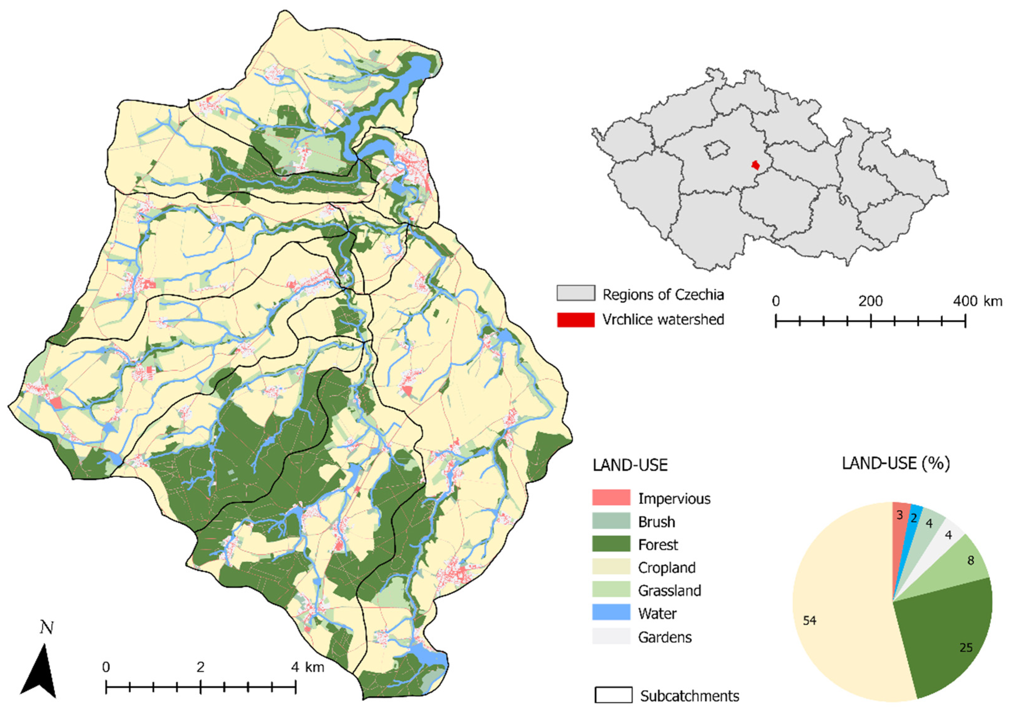
Figure 1. Vrchlice reservoir watershed and its general landscape composition.
Sustainability 14 05748 g001
Figure 2. Maps representing the 1938 land use (a) with and (b) without farmland fragmentation, (c) the location of the sub-basin (corresponds to Figure 1).
Sustainability 14 05748 g002
Figure 3. Land use cover as a percentage across the Vrchlice reservoir watershed.
Sustainability 14 05748 g003
Figure 4. Graphs for selected ponds in the watershed of: (a) the calibration; (b) the sensitivity analysis of the model.
Sustainability 14 05748 g004
Figure 5. Water erosion and hillslope sediment input in the Vrchlice reservoir watershed. Mean water erosion values <0 are on fields with potential for soil loss, while values > 0 are on fields where sediment is potentially deposited.
Sustainability 14 05748 g005
Table 1. Crop cover percentage provided by a local farm manager (ZOD Umonin), and C factors for the crops.
CropCover PercentageC Factor
wheat320.12
barley150.17
corn170.72
arable fodder90.02
rapeseed220.22
oilseed50.6
Table 2. Scenarios analyzed in this study and varying input parameters. * FF (farmland fragmentation).
EffectsRepresented PeriodVarying Input Parameter
Crop rotationpre-Communist
CommunistC factor for crops
Post-Communist
Farmland fragmentationWith FF * (pre-Communist)C factor maps, parcel map
Without FF * (Communist, post-Communist)
Changes in land usePre-Communist
Early Communistparcel maps
Late Communist
Post-Communist
Table 3. Typical crop cover percentage in the Czech Republic [37,38], and C factors for the crops.
CropPre-CommunistCommunistC Factor
winter wheat15%35%0.12
spring barley15%30%0.15
potatoes20%10%0.44
oats25%15%0.10
rye25%10%0.17
Table 4. Calibration parameters (parcel trap efficiency, parcel connectivity, and transport capacity).
ParameterMethodMinimumSelectedMaximum
PTEF crop lands
PTEF forests and pastures
PC crop lands
Recommended *000
Recommended *2575100
Adjusted01040
PC forests and pasturesAdjusted1020100
KTC lowAdjusted10150250
KTC highAdjusted20250400
KTC limitRecommended * 0.1
* Values recommended by Krása [22].
Table 5. Modeled annual average sediment deposition versus measured annual average sediment deposition into ponds. The table is color-coded; green is for difference less than 30%, followed by yellow, red is for difference over 85%.
NameModeled Deposition (Tons/Year)Measured Deposition (Tons/Year)
Hamersky 131303825
Steklik 2881817
Navesky 392131
Jesterny 4282640
Pracny 567427
Vackar 645470
Novy Opatovicky 781835
Mlynsky 81031288
1–8 Their location is in Figure 5.
Table 6. The effects of crop rotations in tons per year.
Crop rotationTotal Sediment ProductionTotal Sediment YieldTotal River Export
Pre-communist41,37015,32020
Communist34,94013,86010
Post-communist55,17018,12030
Table 7. Pond sediment deposition in tons per year according to varying crop rotations.
Crop RotationVrchliceHamerskySteklikNavesky
Pre-communist1593262974278
Communist1443237867171
Post-communist1890313088292
Table 8. The effect of farmland fragmentation (FF) in tons per year (in a representative sub-basin).
Crop RotationTotal Sediment ProductionTotal Sediment YieldTotal River Export
With FF 15,2906000260
Without FF 19,2407020330
Table 9. The effects of different land uses in tons per year.
Land UseTotal Sediment ProductionTotal Sediment YieldTotal Pond DepositionTotal River Export
Pre-communist47,46017,62071601590
Early communist51,01019,01046904920
Late communist60,64022,23011,88070
Post-communist55,17018,120969030
Table 10. The effects of different land uses in tons per year.
PilskyVrchliceHamerskySteklikNavesky
Land use/basin size in km2979779122
Pre-communist147-*309184526
Early communist-*-*-*101077
Late communist-*24883490116475
Post-communist-*1890313088292
* The pond was decommissioned during the period.
Table 11. Total sediment yield in tons per year for each scenario.
Land Use
Post-
Communist
Late
Communist
Early
Communist
Pre-
Communist
Post-Communist + Farmland Fragmentation
Crop rotationPost-communist
Communist
18,11522,23019,01017,62015,398
13,856-*-*-*-*
Pre-communist15,322-*-*-*-*
* This combination was not analyzed in this study.
Table 12. Sediment deposition in Hamersky pond in tons per year for each scenario.
Land Use
Post-
Communist
Late
Communist
Early
Communist
Pre-
Communist
Post-Communist + Farmland Fragmentation
Crop rotationPost-communist
Communist
31303490-**30912660
2378-*-*-*-*
Pre-communist2629-*-*-*-*
* This combination was not analyzed in this study. ** Hamersky pond was demised during the period.
Publisher’s Note: MDPI stays neutral with regard to jurisdictional claims in published maps and institutional affiliations.