
Explorations of Young People’s Sense of Place Using Urban Design Qualities in Surabaya, Indonesia


Abstract
1. Introduction
2. Literature Review
2.1. Sense of Place
2.2. Walking and a Sense of Place
2.3. Urban Design Qualities and a Sense of Place
2.4. Participatory Studies of Walkability
3. Methodology
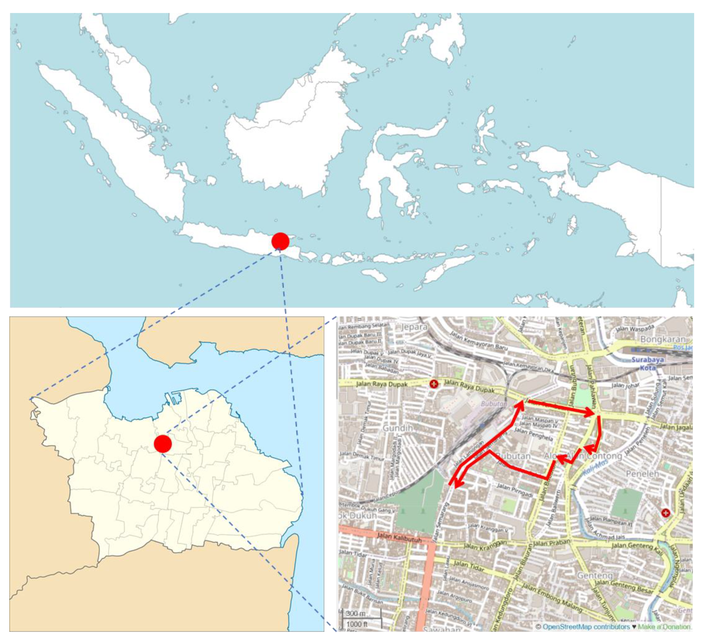
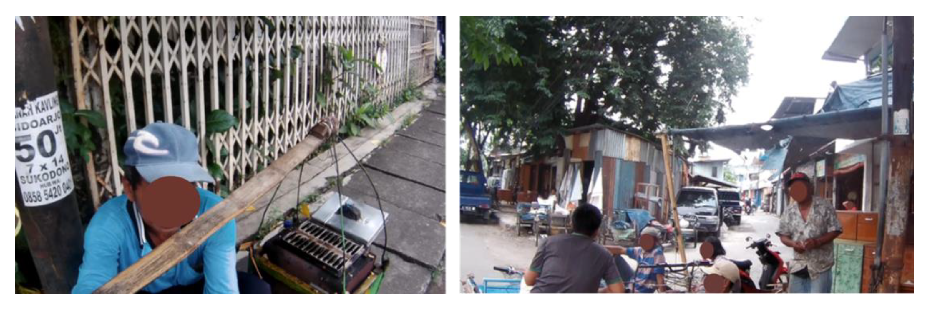
4. Site Selection and Procedures
4.1. Surabaya, Indonesia
4.2. Recruitment of Participants
4.3. Implementation
4.3.1. Walking Session
4.3.2. In-Depth Interview
- -
- Have you ever walked in some corridors of this area before?
- -
- What did you think about the walking session, and what were your impressions of this place?
- -
- Were there any objects that attracted or bothered you? What were they?
- -
- Would you tell us the reasons?
- -
- What was your reason or motive for taking this photograph?
- -
- Why did you put it as a favourable/unfavourable object?
- -
- Why did you like/dislike it?
4.3.3. Workshop
4.3.4. Coding
5. Findings
5.1. Review of Selected Photographs
5.2. Urban Design Qualities and Individual Reactions
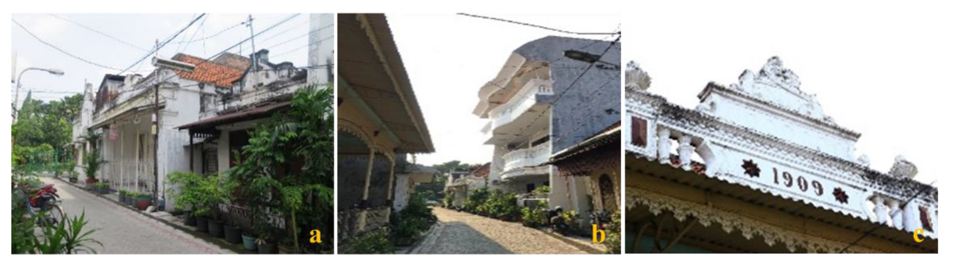
5.2.1. Imageability
5.2.2. Enclosure
5.2.3. Human Scale
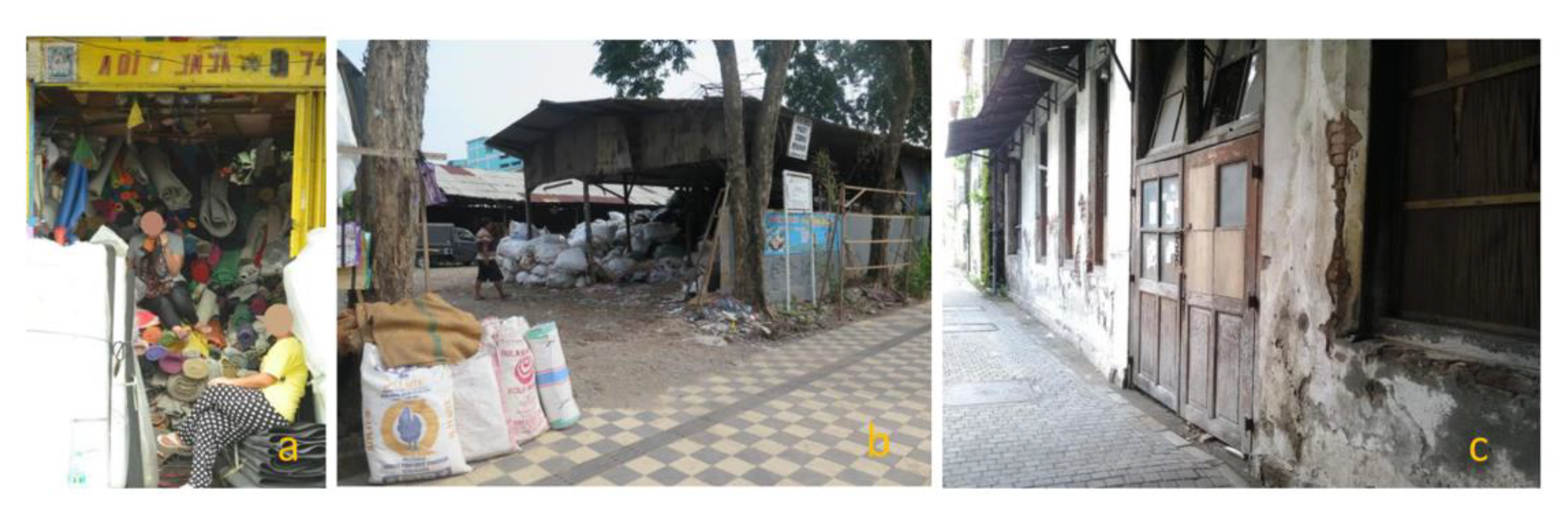
5.2.4. Transparency
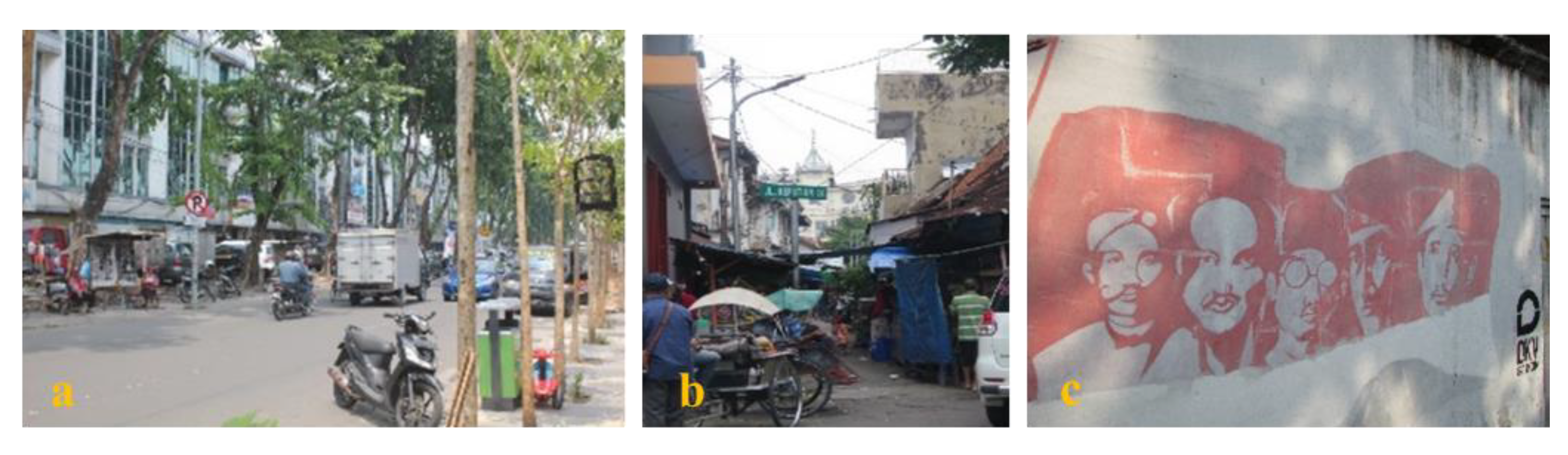
5.2.5. Complexity
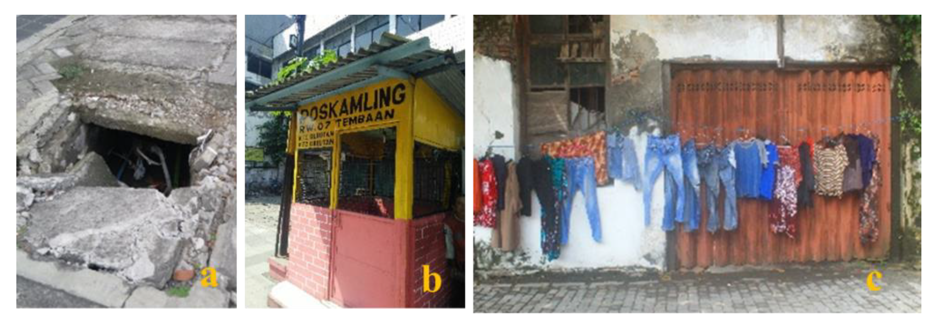
5.2.6. Sense of Safety and Sense of Comfort
5.3. Shared Perceptions through Workshop
6. Discussion
6.1. Understanding the Sense of Place through Urban Design Qualities
6.2. Shared Objects and Contribution to Urban Design
6.3. Limitations and Future Studies
7. Conclusions
Author Contributions
Funding
Institutional Review Board Statement
Informed Consent Statement
Data Availability Statement
Acknowledgments
Conflicts of Interest
References
- Ilahi, A.; Waro, I.; Sumarsono, P. Public transport reform in Indonesian cities. In Proceedings of the 11th International Conference of the Eastern Asia Society for Transportation Studies (EASTS), Cebu, Philippines, 11–13 September 2015. [Google Scholar]
- Roberts, M.; Frederico, G.S.; Sailesh, T. Time to ACT: Realizing Indonesia’s Urban Potential; World Bank: Washington, DC, USA, 2019; Available online: http://hdl.handle.net/10986/31304 (accessed on 15 May 2021).
- Bappenas. Rencana Pembangunan Jangka Menengah Nasional (RPJMN) 2020–2024. 2020. Available online: https://www.bappenas.go.id/files/rpjmn/Narasi%20RPJMN%20IV%202020-2024_Revisi%2014%20Agustus%202019.pdf (accessed on 20 July 2020). (In Bahasa Indonesia).
- Kenworthy, J. Automobile dependence in Bangkok: An international comparison with implications for planning policies. In Earthscan Reader on World Transport Policy and Practice; Whitelegg, J., Haq, G., Eds.; Earthscan Publications: London, UK, 2003; pp. 61–77. [Google Scholar]
- Statistics Indonesia. Perkembangan Jumlah Kendaraan Bermotor Menurut Jenis, 1949–2018. 2020. Available online: https://www.bps.go.id/linkTableDinamis/view/id/1133 (accessed on 20 July 2020). (In Bahasa Indonesia).
- World Bank. Indonesia’s Urban Story. Chapter 4. Transport. 2016. Available online: https://www.dropbox.com/s/q79vtnw7yseoe8j/Transportation.pdf?dl=0ortation.pdf(dropbox.com) (accessed on 21 June 2021).
- Wibowo, S.S. The development of walking environment measures for Indonesia cities. J. Technol. Soc. Sci. 2017, 1, 40–54. [Google Scholar]
- Nugroho, S.B.; Zusman, E.; Nakano, R. Pedestrianisation programs and its impacts on the willingness to increase walking distance in Indonesian cities. The case of Bandung City and Bogor City, Indonesia. In Proceedings of the 23rd International Conference of Hongkong Society for Transportation Studies, Hong Kong, China, 8–10 December 2018. [Google Scholar]
- Hidayati, I.; Yamu, C.; Tan, W. How neglecting walking increases socio-economic inequalities: Impeding urban sustainable mobility: Insights from Jakarta, Indonesia. In Proceedings of the 12th International Space Syntax Symposium, Beijing, China, 8–13 July 2019; pp. 420.1–420.12. [Google Scholar]
- Rakhmatulloh, A.R.; Dewi, D.I.K.; Nugraheni, D.M.K. The built environment and its impact on transit based transportation users walking activity in Semarang, Indonesia. Pertanika J. Sci. Technol. 2021, 29, 771–789. [Google Scholar] [CrossRef]
- Wijaya, S. Walking to transit (Study case: Pasar Senen Station, Jakarta, Indonesia). IOP Conf. Ser. Earth Environ. Sci. 2021, 780, 012034. [Google Scholar] [CrossRef]
- Yulisa, D.K.; Baitul, S. The effect of walking exercise on blood pressure in the elderly with hypertension in Mulyoharjo Community Health Center Pemalang. Public Health Perspect. J. 2018, 3, 176–184. [Google Scholar]
- Lewicka, M. Place attachment: How far have we come in the last 40 years? J. Environ. Psychol. 2011, 31, 207–230. [Google Scholar] [CrossRef]
- Hashemnezhad, H.; Heidari, A.A.; Hoseini, P.H. “Sense of Place” and “Place Attachment” (A Comparative Study). Int. J. Archit. Urban Dev. 2013, 3, 5–12. [Google Scholar]
- Van den Berg, P.; Larosi, H.; Maussen, S.; Arentze, T. Sense of place, shopping area evaluation, and shopping behaviour. Geogr. Res. 2021, 59, 584–598. [Google Scholar] [CrossRef]
- Ujang, N.; Zakariya, K. The notion of place, place meaning and identity in urban regeneration. Procedia-Soc. Behav. Sci. 2015, 170, 709–717. [Google Scholar] [CrossRef]
- Erfani, G. Sense of place as an investigative method for the evaluation of participatory urban redevelopment. Cities 2020, 99, 102648. [Google Scholar] [CrossRef]
- Funo, S.; Yamamoto, N.; Silas, J. Typology of Kampung houses and their transformation process—A Study on urban tissue of an Indonesian City. J. Asian Archit. Build. Eng. 2002, 1, 193–200. [Google Scholar] [CrossRef]
- Ernawati, R.; Santosa, H.R.; Setijanti, P. Facing urban vulnerability through Kampung development, Case study of Kampungs in Surabaya, Indonesia. Humanit. Soc. Sci. 2013, 1, 1–6. [Google Scholar] [CrossRef][Green Version]
- Shirleyana Hawken, S.; Sunindijo, Y. City of Kampung: Risk and resilience in the urban communities of Surabaya, Indonesia. Int. J. Build. Pathol. Adapt. 2018, 36, 543–568. [Google Scholar] [CrossRef]
- Horelli, L. A methodology of participatory planning. In Handbook of Environmental Psychology; Chapter 38; Bechtel, R.B., Churchman, A., Eds.; John Wiley & Sons: New York, NY, USA, 2002; pp. 607–628. [Google Scholar]
- Ewing, R.; Handy, S. Measuring the unmeasurable: Urban design qualities related to walkability. J. Urban Des. 2009, 14, 84. [Google Scholar] [CrossRef]
- Ewing, R.; Clemente, O. Measuring Urban Design: Metrics for Livable Places; Island Press: Washington, DC, USA, 2013. [Google Scholar]
- Najafi, M.; Shariff, M.K.B.M. The concept of place and sense of place in architectural studies. World Acad. Sci. Eng. Technol. 2011, 56, 1100–1106. [Google Scholar]
- Steele, F. The Sense of Place; CBI Publishing Company: Boston, MA, USA, 1981. [Google Scholar]
- Adams, J.D. Theorizing a sense of place in transnational community. Child. Youth Environ. 2013, 23, 43–65. [Google Scholar] [CrossRef]
- Tuan, Y.F. Topophilia: A Study of Environmental Perception, Attitudes, and Values; Columbia University Press: New York, NY, USA, 1974. [Google Scholar]
- Sattarzadeh, D.; Asl, L.B. Identification of the components of sense of place in architecture of houses in First Pahlavi Era in Iran (Case Study: Tabriz). Eur. Online J. Nat. Soc. Sci. 2015, 3, 436–450. [Google Scholar]
- Qazimi, S. Sense of place and place identity. Eur. J. Soc. Sci. Educ. Res. 2014, 1, 306–311. [Google Scholar] [CrossRef]
- Ujang, N.; Shamsudin, S. The influence of legibility on attachment towards the shopping streets of Kuala Lumpur. Pertanika J. Soc. Sci. Humanit. 2012, 20, 81–92. [Google Scholar]
- Moughtin, C.; Oc, T.; Tiesdell, S. Urban Design: Ornament and Decoration, 2nd ed.; Architectural Press: Oxford, UK, 1999. [Google Scholar]
- Arefi, M. Non-place and placelessness as narratives of loss: Rethinking the notion of place. J. Urban Des. 1999, 4, 179–193. [Google Scholar] [CrossRef]
- Montgomery, J. Making a city: Urbanity, vitality and urban design. J. Urban Des. 1998, 3, 93–116. [Google Scholar] [CrossRef]
- Ramadhani, A.N.; Faqih, M.; Hayati, A. Inhabitant’s sense of place in the context of tourism Kampung. J. Archit. Environ. 2018, 17, 151–168. [Google Scholar] [CrossRef]
- Kopec, D. Environmental Psychology for Design; Fairchild Books: New York, NY, USA, 2018. [Google Scholar]
- Gentry, G.W. Walking with the dead: The place of ghost walk tourism in Savannah, Georgia. S. Geogr. 2007, 47, 222–238. [Google Scholar] [CrossRef]
- Aoki, J.; Yoshimizu, A. Walking histories, un/making places: Walking tours as ethnography of place. Space Cult. 2015, 18, 273–284. [Google Scholar] [CrossRef]
- Tuan, Y.F. Space and Place: The Perspective of Experience; University of Minnesota Press: Minneapolis, MN, USA, 1977. [Google Scholar]
- Gehl, J.; Kaefer, L.J.; Reigstad, S. Close encounters with buildings. Urban Des. Int. 2006, 11, 29–47. [Google Scholar] [CrossRef]
- Belshaw, K. Sense of place and walking tours: A case study of the Tour Guys Downtown Toronto Tour. Master’s Thesis, University of Waterloo, Waterloo, ON, Canada, 2017. Available online: http://hdl.handle.net/10012/11849 (accessed on 23 October 2021).
- Gehl, J.; Svarre, B. How to Study Public Life; Island Press: Washington, DC, USA, 2013. [Google Scholar]
- Mehaffy, M.W.; Kryazhewa, Y.; Rudd, A.; Salingaros, N.A. A New Pattern Language for Growing Regions: Places, Networks, Processes; Sustasis Press: Portland, OR, USA, 2020. [Google Scholar]
- Salingaros, N.A. The biophilic healing index predicts effects of the built environment on our wellbeing. J. Biourbanism 2019, 8, 13–34. [Google Scholar]
- Curtis, W. The Last Great Walk: The True Story of a 1909 Walk from New York to San Francisco, and Why It Matters Today; Rodale Books: New York, NY, USA, 2014. [Google Scholar]
- Lang, J. Creating Architectural Theory: The Role of the Behavioral Sciences in Environmental Design; Van Nostrand Reinhold: New York, NY, USA, 2010. [Google Scholar]
- Monfries, J. The psychological effects of urban design. Topophilia 2020, 46–52. [Google Scholar] [CrossRef]
- Rofé, Y. The meaning and usefulness of the “feeling map” as tool in planning and urban design. In Pursuit of a Living Architecture: Continuing Christopher Alexander’s Quest for a Humane and Sustainable Building Culture; Chapter 15; Pontikis, K., Rofé, Y., Eds.; Common Ground Publishing: Champaign, IL, USA, 2016. [Google Scholar] [CrossRef]
- Rofé, Y. Feeling maps, diagnosis, generative planning and urban design. In Generative Process, Patterns and the Urban Challenge, Proceedings of the PUARL International Conference, Portland, OR, USA, 28–30 October 2011; Neis, H., Brown, G.A., Gurr, J.M., Schmidt, A., Eds.; University of Oregon: Eugene, OR, USA, 2011; pp. 217–226. [Google Scholar]
- Specks, J. Walkable City Rules 101 Steps to Making Better Places; Island Press: Washington, DC, USA, 2018. [Google Scholar]
- McCluskey, J. Roadform and Townscape, 2nd ed.; Architectural Press: London, UK, 1992. [Google Scholar]
- Nugroho, S. The improvement of old building visibility, Krembangan Barat Street of Surabaya as of case study. ATRIUM 2015, 1, 167–179, (In Bahasa Indonesia). [Google Scholar] [CrossRef]
- Baudino, I. Marianne Colton’s art of walking: Gendering the picturesque in Journal of a Tour of France, Switzerland, and Italy. In Walking and the Aesthetic of Modernity; Benesch, K., Specq, F., Eds.; Springer Nature: New York, NY, USA, 2016; pp. 85–98. [Google Scholar] [CrossRef]
- Ewing, R.; Handy, S.; Brownson, R.C.; Clemente, O.; Winston, E. Identifying and measuring urban design qualities related to walkability. J. Phys. Act. Health 2006, 3, S223–S240. [Google Scholar] [CrossRef]
- Hooi, E.; Pojani, D. Urban design qualities and walkability: An audit of suburban high streets in an Australian City. J. Urban Des. 2019, 25, 155–179. [Google Scholar] [CrossRef]
- Bereitschaft, B. Equity in microscale urban design and walkability: A photographic survey of six Pittsburgh streetscapes. Sustainability 2017, 9, 1233. [Google Scholar] [CrossRef]
- Lynch, K. The Image of the City; MIT Press: Cambridge, UK, 1960. [Google Scholar]
- Hillier, B.; Hanson, J. The Social Logic of Space; Cambridge University Press: Cambridge, UK, 1984. [Google Scholar]
- Yamu, C.; van Nes, A.; Garau, C. Bill Hillier’s legacy: Space syntax—A synopsis of basic concepts, measures, and empirical application. Sustainability 2021, 13, 3394. [Google Scholar] [CrossRef]
- Sholihah, A.B. The Qualities of Traditional Streets in Indonesia. Doctoral Dissertation, Department of Architecture and Built Environment, University of Nottingham, Nottingham, UK, 2016. [Google Scholar]
- Muhaemin, A.B. Walkability: Perspective from local neighborhood in Bandar Lampung Indonesia. Inov. Pembang.–J. Kelitbangan 2019, 7, 1–14. [Google Scholar] [CrossRef]
- Damayanti, R.; Kossak, F. Extending Kevin Lynch’s concept of imageability in third space reading; case study of Kampungs, Surabaya–Indonesia. A/Z ITU J. Fac. Archit. 2016, 13, 57–67. [Google Scholar] [CrossRef]
- Taylor, R.P. The potential of biophilic fractal designs to promote health and performance: A review of experiments and applications. Sustainability 2021, 13, 823. [Google Scholar] [CrossRef]
- Joye, Y. Fractal architectural could be good for you. Nexus Netw. J. 2007, 9, 311–320. [Google Scholar] [CrossRef]
- Alexander, C.; Ishikawa, S.; Silverstein, M.; Jacobson, M.; Fiksdahl-King, I.; Angel, S. A Pattern Language: Towns, Buildings, Construction; Oxford University Press: New York, NY, USA, 1977. [Google Scholar]
- Jacobs, A.B. Great Streets; MIT Press: Boston, MA, USA, 1995. [Google Scholar]
- Mehta, V. Evaluating public space. J. Urban Des. 2014, 19, 88. [Google Scholar] [CrossRef]
- Jacobs, J. The Death and Life of Great American Cities; Random House: New York, NY, USA, 1961. [Google Scholar]
- Johansson, M.; Sternudd, C.; Kärrholm, M. Perceived urban design qualities and affective experiences of walking. J. Urban Des. 2016, 21, 256–275. [Google Scholar] [CrossRef]
- Ernawati, J.; Adhitama, M.S.; Sudarmo, B.S. Urban design qualities related walkability in a commercial neighbourhood. In Proceedings of the 7th Asia-Pacific International Conference on Environment-Behaviour Studies, St Leonard Hall, Edinburgh University, Edinburgh, UK, 27–30 July 2016. [Google Scholar] [CrossRef]
- Naoi, T.; Yamada, T.; Iijima, S.; Kumazawa, T. Applying the Caption Evaluation Method to Studies of Visitors’ Evaluation of Historical Districts. Tour. Manag. 2011, 32, 1061–1074. [Google Scholar] [CrossRef]
- Rollo, J.; Barker, S. Perception of place—Evaluating experiential qualities of streetscapes. In Proceedings of the State of Australian Cities (SOAC) Conference, Sydney, NSW, Australia, 26–29 November 2013. [Google Scholar]
- Honey-Rosés, J. A Review of Field Experiments in Planning and Urban Research. Plan. Pract. Res. 2019, 34, 558–572. [Google Scholar] [CrossRef]
- Cullen, G. Townscape; The Architectural Press: New York, NY, USA, 1961. [Google Scholar]
- Kalin, A.; Yilmaz, D. A study on visibility analysis of urban landmarks: The case of Hagia Sophia (Ayasofia) in Trabzon. METU J. Fac. Archit. 2012, 29, 241–271. [Google Scholar] [CrossRef]
- Garrod, B. Exploring place perception, a photo-based analysis. Ann. Tour. Res. 2008, 35, 381–401. [Google Scholar] [CrossRef]
- Balomenou, N.; Garrod, B. Using volunteer-employed photography to inform tourism planning decisions: A study of St David’s Peninsula, Wales. Tour. Manag. 2014, 44, 126–139. [Google Scholar] [CrossRef]
- Ruane, S.T.; Quinn, B.; Spencer, C.; Flanagan, S. Reporting on the utility of volunteer employed photography as part of a multi-method approach to exploring Ireland’s destination image. In Proceedings of the 6th Annual Conference on Tourism and Hospitality Research, Shannon, Ireland, 16–17 June 2010. [Google Scholar]
- Joye, Y. Architectural lessons from environmental psychology: The case of biophilic architecture. Rev. Gen. Psychol. 2007, 11, 305–328. [Google Scholar] [CrossRef]
- Baskoro, S. Surabaya as a modern colonial city in the end of the 19th century: Industry, transportation, housing, and multiculturalism of society. Mozaik Hum. 2017, 17, 157–180. [Google Scholar] [CrossRef]
- Cahyani, R.; Wulandari, L.D.; Antariksa, A. Pengaruh Arsitektur Tradisional Jawa dalam Hunian Kolonial di Kampung Bubutan Surabaya (The influence of traditional Javanese architecture on colonial housing in Kampung Bubutan Surabaya). J. RUAS 2015, 13, 56–65, (In Bahasa Indonesia). [Google Scholar] [CrossRef][Green Version]
- Wirastari, V.A.; Suprihardjo, R. Pelestarian Kawasan Cagar Budaya Berbasis Partisipasi Masyarakat (Studi Kasus: Kawasan Cagar Budaya Bubutan, Surabaya). J. Tek. ITS 2012, 1, C-63–C-67, (In Bahasa Indonesia). [Google Scholar] [CrossRef]
- Sung, H.; Oh, J.T. Transit-oriented development in a high-density city: Identifying its association with transit ridership in Seoul, Korea. Cities 2011, 28, 70–82. [Google Scholar] [CrossRef]
- Shen, H.; Zou, B.; Lin, J.; Liu, P. Modeling travel mode choice of young people with differentiated E-hailing ride services in Nanjing China. Transp. Res. Part D Transp. Environ. 2020, 78, 102216. [Google Scholar] [CrossRef]
- Ganis, M. Planning Urban Places Self-Organising Places with People in Mind; Routledge: New York, NY, USA, 2015. [Google Scholar]
- Gaber, J.; Gaber, S. Qualitative Analysis for Planning & Policy; Planners Press: Washington, DC, USA, 2007. [Google Scholar]
- Bush-Kaufman, A.; Barale, K.; Walsh, M.; Sero, R. In-depth qualitative interviews to explore healthy environment strategies in food pantries in the western United States. J. Acad. Nutr. Diet. 2019, 119, 1632–1643. [Google Scholar] [CrossRef]
- Arciniegas, G.; Janssen, R. Spatial decision support for collaborative land use planning workshops. Landsc. Urban Plan. 2012, 107, 332–342. [Google Scholar] [CrossRef]
- Niezabitowska, E. Research Methods and Techniques in Architecture; Routledge: New York, NY, USA, 2018. [Google Scholar] [CrossRef]
- Saldana, J. The Coding Manual for Qualitative Researchers; SAGE Publications: London, UK, 2016. [Google Scholar]
- Mayes, T.M. Why Old Places Matter: How Historic Places Affect Our Identity and Well-Being; Rowman & Littlefield Publishers: London, UK, 2018. [Google Scholar]
- Isa, S.M.; Ariyanto, H.H.; Kiumarsi, S. The effect of place attachment on visitors’ revisit intentions: Evidence from Batam. Tour. Geogr. 2019, 22, 51–82. [Google Scholar] [CrossRef]
- Patwardhan, V.; Ribeiro, M.A.; Payini, V.; Woosnam, K.M.; Mallya, J.; Gopalakrishnam, P. Visitors’ place attachment and destination loyalty: Examining the roles of emotional solidarity and perceived safety. J. Travel Res. 2020, 59, 3–21. [Google Scholar] [CrossRef]
- Patwardhan, V.; Ribeiro, M.A.; Woosnam, K.M.; Payini, V.; Mallya, J. Visitors’ loyalty to religious tourism destinations: Considering place attachment, emotional experience and religious affiliation. Tour. Manag. Perspect. 2020, 36, 100737. [Google Scholar] [CrossRef]
- Chen, N.; Hall, C.M.; Yu, K.; Qian, C. Environmental satisfaction, residential satisfaction, and place attachment: The cases of long-term residents in rural and urban areas in China. Sustainability 2019, 11, 6439. [Google Scholar] [CrossRef]
- Harun, N.Z.; Mansor, M.; Said, I. Place rootedness suggesting the loss and survival of historical public spaces. Procedia Environ. Sci. 2015, 28, 528–537. [Google Scholar] [CrossRef]
- Llinares, C.; Montañana, A.; Navarro, E. Differences in architects and nonarchitects’ perception of urban design: An application of Kansei Engineering techniques. Urban Stud. Res. 2011, 2011, 736307. [Google Scholar] [CrossRef]


| Definition | Keyword | |
|---|---|---|
| Imageability | The qualities of a place that make it unique and legible. A place creates an impression and evokes feelings and emotions | Major landscapes, historic buildings, identifiers, etc. |
| Enclosure | The presence of imaginary defined space by the vertical (buildings, walls, trees, etc.) and horizontal (sky, trees, roof, etc.) elements. | Street segment with street wall, proportion of street wall and sky. |
| Transparency | The degree of visual connection which people can see; what lies beyond the street. | Windows, proportion of sky, arrangement of street furniture, active uses. |
| Human scale | A physical element is designed in relation to human size and proportion corresponding to human walking speed. | Building height, building details, texture, planters, visible street furniture, and street vendors. |
| Complexity | The visual richness of a place, which depends on the variety of the physical environment (the numbers and kinds of buildings, architectural diversity and ornamentation, landscape elements, street furniture, signage, and human activity). | Building colours, building accents, outdoor dining, public art, activities occurred in adjacent buildings and space. |
| No | Gender | Age | Educational Background | Occupation |
|---|---|---|---|---|
| 1 | Female | 38 | Bachelor: Architecture | Part-time architect |
| 2 | Female | 45 | College: Administrative science | Housewife |
| 3 | Female | 36 | Master: Forensic anthropology | Lecturer |
| 4 | Female | 26 | Master: Architecture | Graduate student |
| 5 | Male | 24 | College: Design | Designer |
| 6 | Female | 19 | Bachelor: Architecture | Student |
| 7 | Female | 19 | Bachelor: Architecture | Student |
| 8 | Female | 19 | Bachelor: Historical science | Student |
| 9 | Male | 20 | Bachelor: Communication science | Student |
| 10 | Female | 20 | Bachelor: Historical science | Student |
| 11 | Male | 19 | Bachelor: Historical science | Student |
| 12 | Female | 26 | Master: Chemical engineering | Lecturer |
| 13 | Male | 26 | Master: Architecture | Graduate student |
| 14 | Female | 25 | Bachelor: Urban planning | City planner |
| 15 | Female | 24 | Bachelor: Civil engineering | Staff for rural improvement |
| 16 | Female | 26 | Master: Urban design | Graduate student |
| 17 | Female | 39 | Bachelor: Architecture | Architect |
| 18 | Male | 25 | Senior high school (social science) | Staff at Hotel |
| 19 | Male | 36 | Bachelor: Economic science | Staff at private company |
| 20 | Male | 24 | Bachelor: Biology | Freelance photographer |
| 21 | Male | 23 | Bachelor: Historical science | Student |
| 22 | Female | 27 | Bachelor: Architecture | Architect |
| 23 | Female | 29 | Master: Design | Journalist, lecturer |
| Transcribed Interviews (Translated to English) | Keywords | Urban Design Qualities |
|---|---|---|
| “This is rare. I have never seen a building like this before. You won’t be aware of this if you ride a motorcycle.” | Prominent, Distinctiveness, visibility | Imageability |
| “This is the most unique shop. Lots of lamps and made me want to come inside.” | Seeing what lies beyond the shopfront, curiosity | Enclosure |
| Participant | Imageability | Enclosure | Human Scale | Transparency | Complexity | Sense of Safety | Sense of Comfort |
|---|---|---|---|---|---|---|---|
| 1 | 3 | - | 2 | 2 | 3 | 6 | 4 |
| 2 | 5 | 2 | 5 | 1 | 4 | - | 3 |
| 3 | 5 | - | 3 | 1 | 4 | 4 | 3 |
| 4 | 1 | - | 13 | 3 | 1 | 1 | 1 |
| 5 | 4 | 2 | 6 | 1 | 3 | 1 | 3 |
| 6 | 1 | 1 | 10 | 1 | 1 | 4 | 2 |
| 7 | 3 | 1 | 4 | 1 | 3 | 2 | 6 |
| 8 | 1 | 1 | 13 | 1 | 1 | - | 3 |
| 9 | 2 | - | 7 | 2 | 1 | 1 | 7 |
| 10 | 2 | - | 10 | 1 | 2 | 3 | 2 |
| 11 | 5 | - | 11 | 2 | 2 | - | - |
| 12 | 1 | 1 | 11 | 1 | - | 3 | 3 |
| 13 | 1 | 2 | 8 | 1 | 4 | - | 4 |
| 14 | 1 | 3 | 7 | - | - | 4 | 5 |
| 15 | 2 | - | 11 | 1 | - | 5 | 1 |
| 16 | - | 2 | 6 | - | 2 | 4 | 6 |
| 17 | 7 | 3 | 4 | - | 1 | 5 | - |
| 18 | 3 | 1 | 10 | - | 1 | 2 | 3 |
| 19 | 2 | 1 | 5 | 1 | 2 | 3 | 6 |
| 20 | 4 | - | 8 | - | 1 | 3 | 4 |
| 21 | 6 | - | 4 | - | 3 | 1 | 6 |
| 22 | 4 | 1 | 6 | 1 | - | 4 | 4 |
| 23 | 2 | - | 13 | 1 | - | 1 | 3 |
| Total | 65 | 21 | 177 | 22 | 39 | 57 | 79 |
| Summarized Items | N |
|---|---|
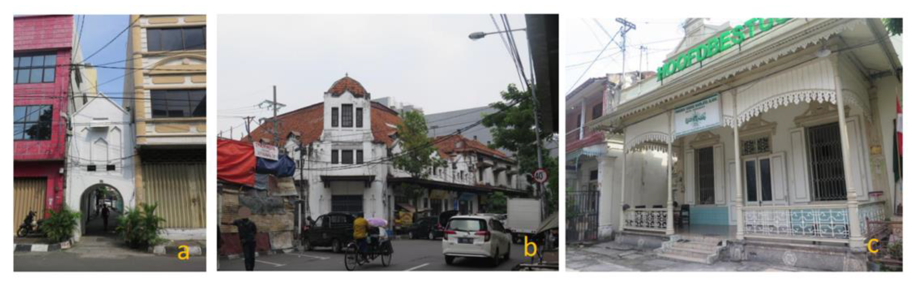
| Distinctive characteristics of old buildings (form, visual details, architectural style, and colour) | 45 |
| Prominent as a city landmark because of its size and location | 8 |
| Adaptive reuse of old buildings (revitalization) | 5 |
| High potential yet not well-maintained old buildings | 3 |
| Unclear characteristic of street furniture, image of the place | 3 |
| History of the past happened in the building | 1 |
| Summarized Items | N |
|---|---|
| Enclosed by trees and vegetation | 14 |
| Building’s awning | 3 |
| Enclosed by street furniture | 2 |
| Enclosed by walls of alleys | 2 |
| Summarized Items | N |
|---|---|
| Visual details (windows, ornaments, signs with symbols or letters, etc.) | 65 |
| Space for social interaction | 21 |
| Planters | 20 |
| Street furniture | 14 |
| Human activities | 14 |
| Street vendors | 10 |
| Obstacles for pedestrians | 8 |
| Shop display | 8 |
| Motorized vehicles | 7 |
| Old graveyard | 4 |
| Scale of the street or pedestrian space | 4 |
| Old building’s maintenance | 2 |
| Summarized Items | N |
|---|---|
| Sense of openness | 14 |
| Shops adjacent to streets | 6 |
| Alleyway | 2 |
| Summarized Items | N |
|---|---|
| Crowdedness and mixture of various activities | 27 |
| Complexity of building appearance | 10 |
| Wall painting | 2 |
| Summarized Items | N |
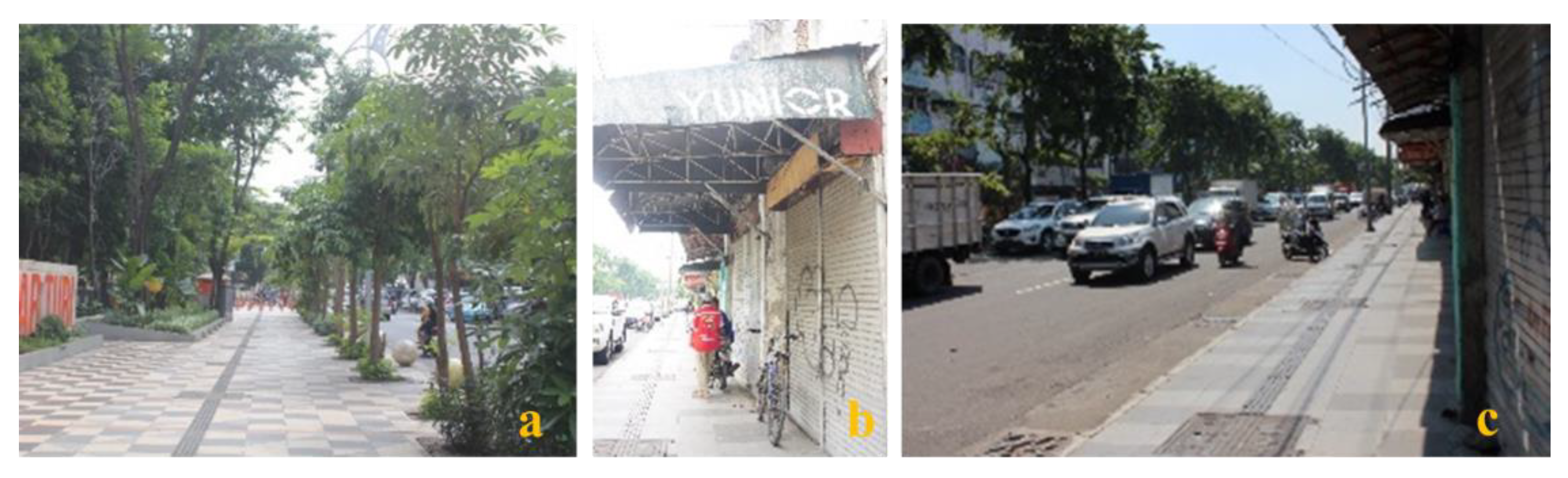
|---|---|
| Traffic safety awareness | 56 |
| Visual comfort | 54 |
| Damaged sidewalk | 23 |
| Unavailable space for waiting | 3 |
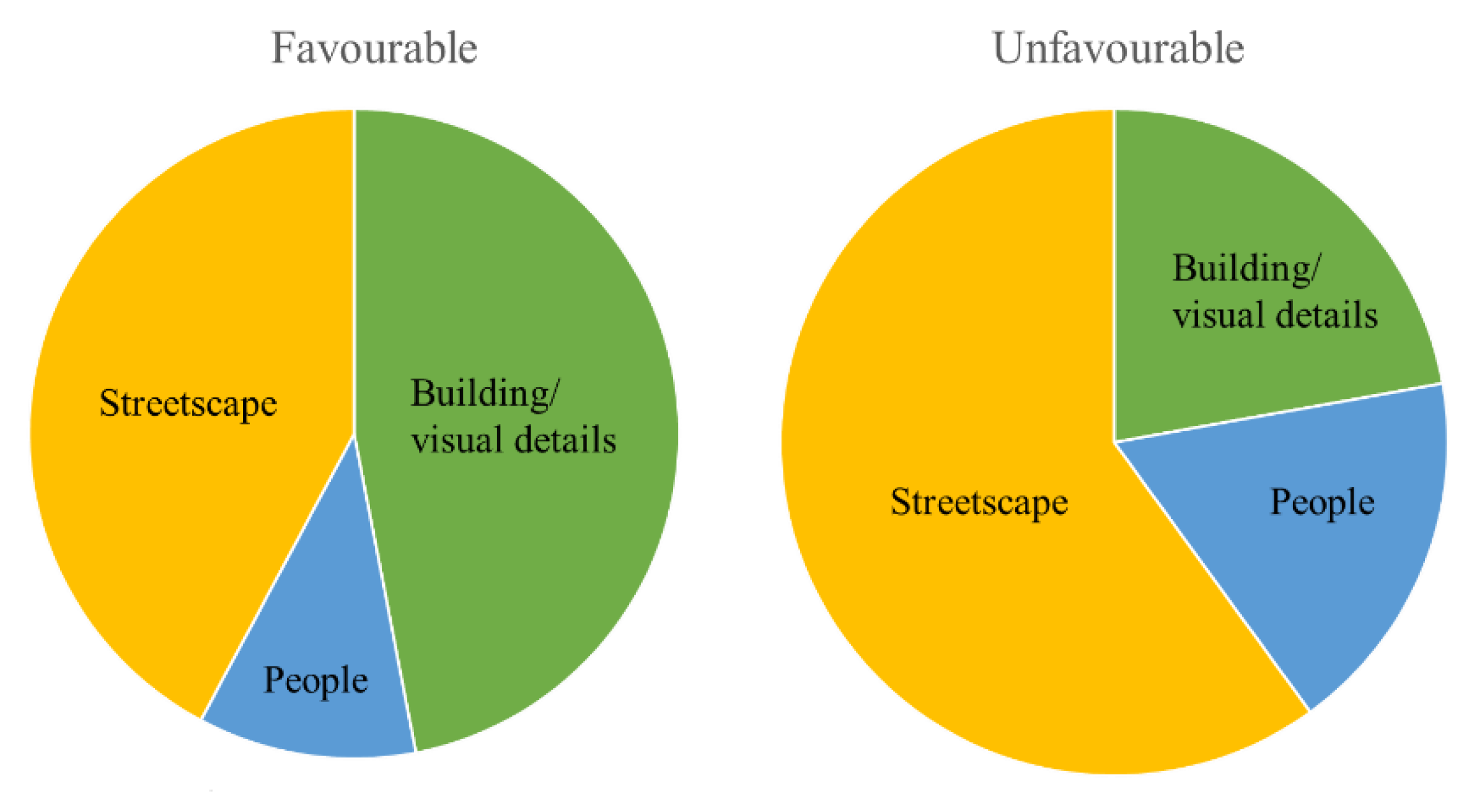
| Favourable | Unfavourable | |
|---|---|---|
| Group 1 | Comfortable sidewalks, friendly people, attractive old buildings’ decoration, calm alleys, unique buildings, unexpected response, and children friendly. | Visually uncomfortable view, negative unexpected response, unhygienic food stalls, uncomfortable sidewalks, chaotic, traffic violation. |
| Group 2 | Comfortable for pedestrians, old buildings, shady and green, unique of mixed land-use, abundance of landmarks, historic, lively activities. | Traffic violation, harmful electrical cable, congested, waste, poorly maintained buildings. |
| Group 3 | Eye-catching, colourful, compactness, space for pedestrians, clean and spacious. | Traffic violation, damaged sidewalks, incompatible function of the space, dirty, congested, less thermal comfort. |
| Group 4 | Lively activities, old buildings, planters and parks, street furniture, solar panel street lighting. | Poorly maintained buildings, sidewalks, traffic behaviour, empty buildings, waste, and poor signage. |
Publisher’s Note: MDPI stays neutral with regard to jurisdictional claims in published maps and institutional affiliations. |
© 2022 by the authors. Licensee MDPI, Basel, Switzerland. This article is an open access article distributed under the terms and conditions of the Creative Commons Attribution (CC BY) license (https://creativecommons.org/licenses/by/4.0/).
Share and Cite
Nugroho, S.; Zhang, J. Explorations of Young People’s Sense of Place Using Urban Design Qualities in Surabaya, Indonesia. Sustainability 2022, 14, 472. https://doi.org/10.3390/su14010472
Nugroho S, Zhang J. Explorations of Young People’s Sense of Place Using Urban Design Qualities in Surabaya, Indonesia. Sustainability. 2022; 14(1):472. https://doi.org/10.3390/su14010472
Chicago/Turabian StyleNugroho, Setyo, and Junyi Zhang. 2022. "Explorations of Young People’s Sense of Place Using Urban Design Qualities in Surabaya, Indonesia" Sustainability 14, no. 1: 472. https://doi.org/10.3390/su14010472
APA StyleNugroho, S., & Zhang, J. (2022). Explorations of Young People’s Sense of Place Using Urban Design Qualities in Surabaya, Indonesia. Sustainability, 14(1), 472. https://doi.org/10.3390/su14010472