
Can Drones Map Earth Cracks? Landslide Measurements in North Greece Using UAV Photogrammetry for Nature-Based Solutions

 ,
,  ,
, 
 and
and 
Abstract
1. Introduction
2. Materials and Methods
2.1. The Study Area
2.2. The UAV
2.3. The Software
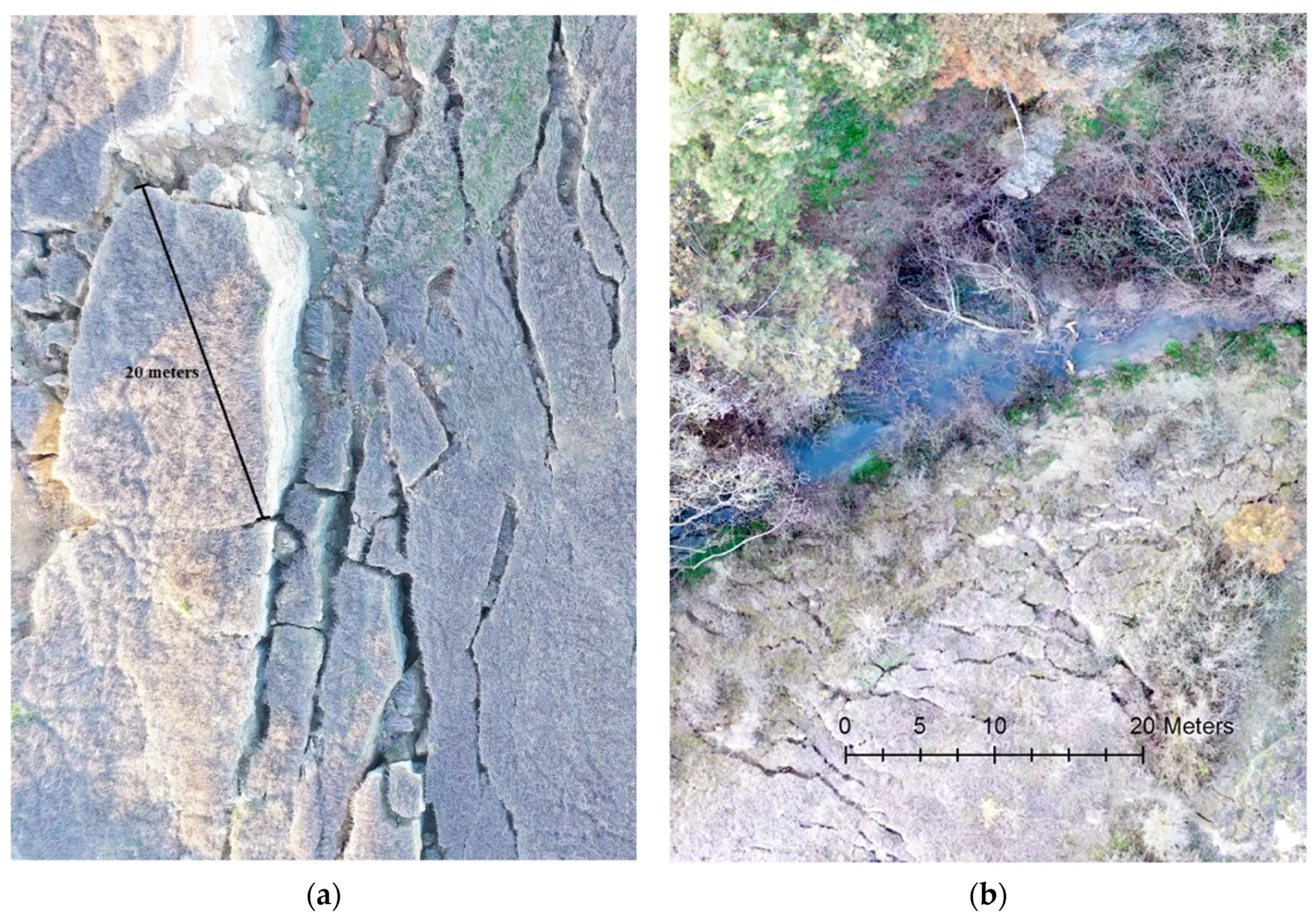
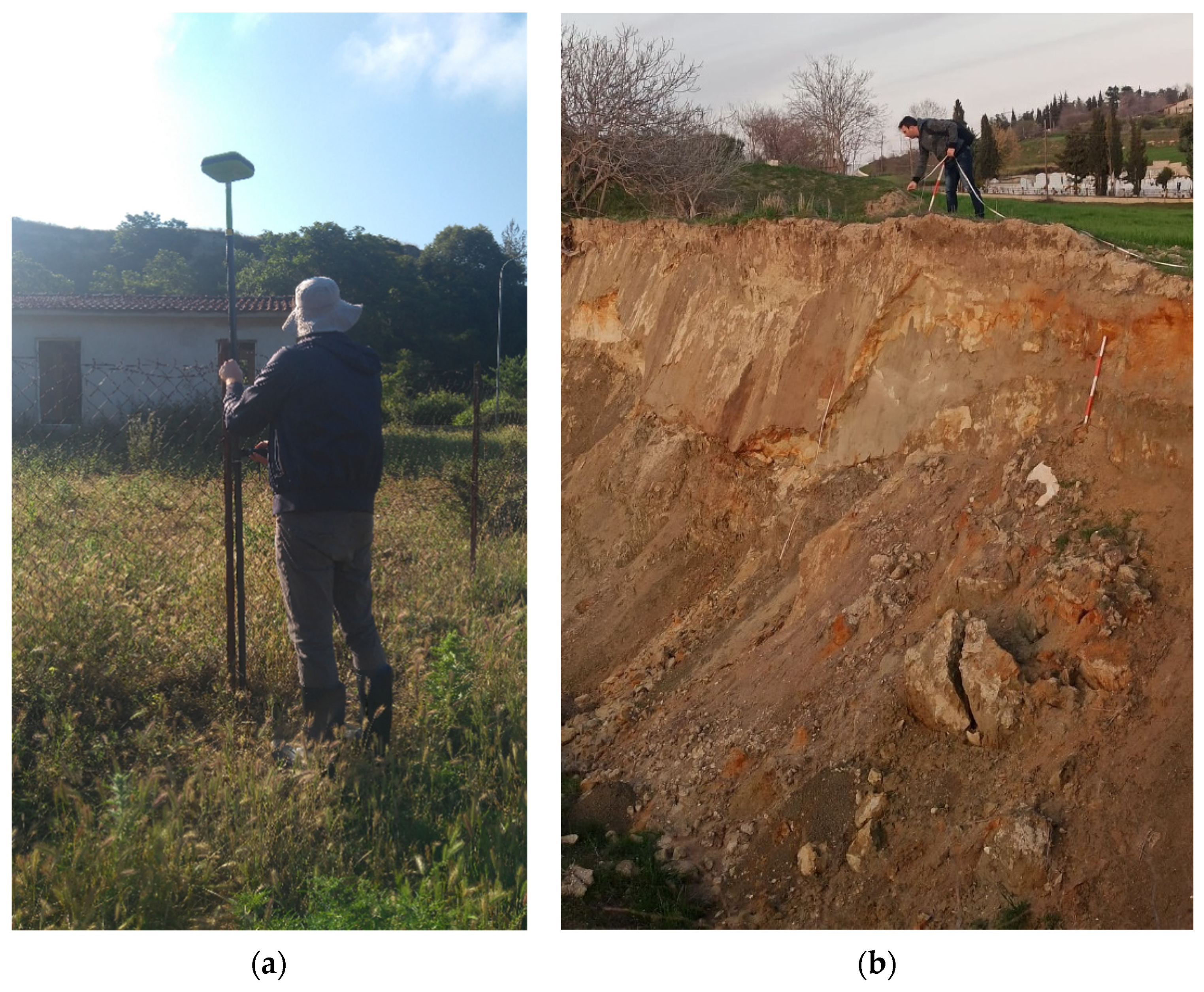
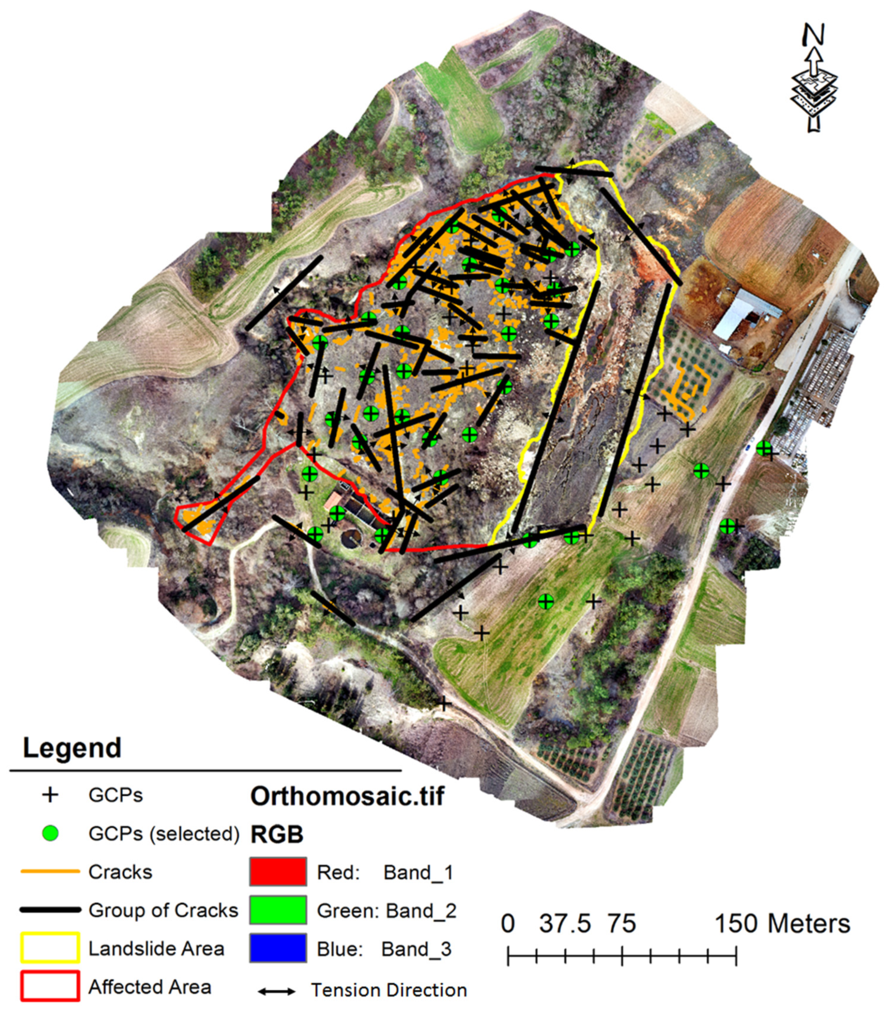
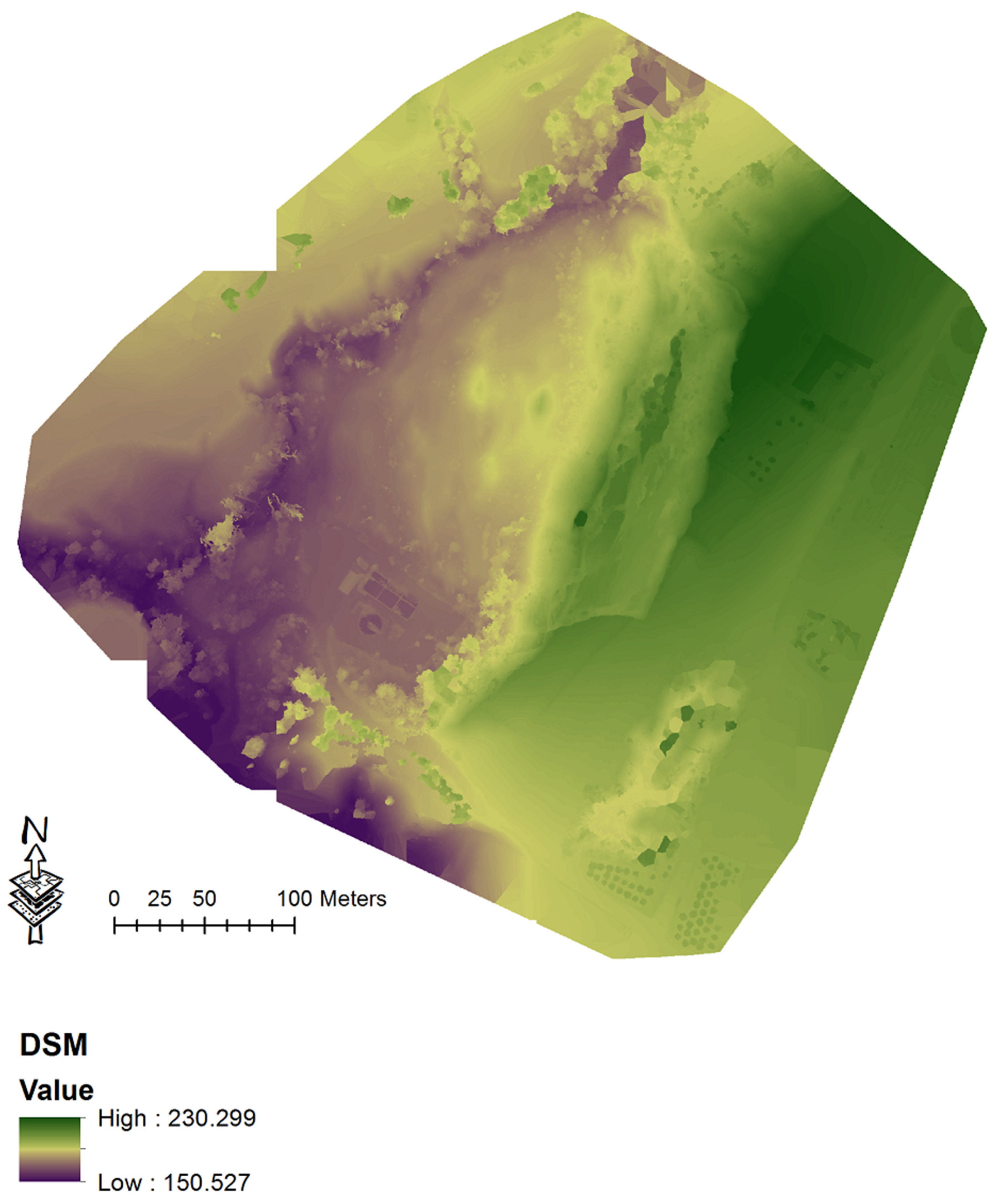
3. Results
4. Discussion
5. Conclusions
Author Contributions
Funding
Institutional Review Board Statement
Informed Consent Statement
Data Availability Statement
Conflicts of Interest
References
- Guzzetti, F.; Carrara, A.; Cardinali, M.; Reichenbach, P. Landslide hazard evaluation: A review of current techniques and their application in a multi-scale study, Central Italy. Geomorphology 1999, 31, 181–216. [Google Scholar] [CrossRef]
- Kazeev, A.; Postoev, G. Landslide investigations in Russia and the former USSR. Nat. Hazards 2017, 88, 81–101. [Google Scholar] [CrossRef]
- Bhandari, R.K. Patterns of subsidence in landslides. In Proceedings of the 5th International Symposium on Land Subsidence, The Hague, The Netherlands, 16–20 October 1995; pp. 403–412. [Google Scholar]
- Varnes, D.J. Slope movement types and processes. In Special Report 176: Landslides: Analysis and Control; Schuster, R.L., Krizek, R.J., Eds.; Transportation and Road Research Board, National Academy of Science: Washington, DC, USA, 1978; pp. 11–33. [Google Scholar]
- Hungr, O.; Leroueil, S.; Picarelli, L. The Varnes classification of landslide types, an update. Landslides 2014, 11, 167–194. [Google Scholar] [CrossRef]
- Highland, L.; Bobrowsky, P.T. The Landslide Handbook: A Guide to Understanding Landslides; Geological Survey: Reston, PA, USA; p. 129.
- Rotaru, A.; Oajdea, D.; Răileanu, P. Analysis of the landslide movements. Int. J. Geol. 2007, 1, 70–79. [Google Scholar]
- Loupasakis, C.; Angelitsa, V.; Rozos, D.; Spanou, N. Mining geohazards—Land subsidence caused by the dewatering of opencast coal mines: The case study of the Amyntaio coal mine, Florina, Greece. Nat. Hazards 2014, 70, 675–691. [Google Scholar] [CrossRef]
- Apostolidis, E.; Koukis, G. Engineering-geological conditions of the formations in the Western Thessaly basin. Greece. Open Geosci. 2013, 5, 407–422. [Google Scholar] [CrossRef]
- Psimoulis, P.; Ghilardi, M.; Fouache, E.; Stiros, S. Subsidence and evolution of the Thessaloniki plain, Greece, based on historical leveling and GPS data. Eng. Geol. 2007, 90, 55–70. [Google Scholar] [CrossRef]
- Castañeda, C.; Gutiérrez, F.; Manunta, M.; Galve, J.P. DInSAR measurements of ground deformation by sinkholes, mining subsidence, and landslides, Ebro River, Spain. Earth Surf. Process. Landf. 2009, 34, 1562–1574. [Google Scholar] [CrossRef]
- Du, Z.; Ge, L.; Ng, A.H.M.; Zhu, Q.; Zhang, Q.; Kuang, J.; Dong, Y. Long-term subsidence in Mexico City from 2004 to 2018 revealed by five synthetic aperture radar sensors. Land Degrad. Dev. 2019, 30, 1785–1801. [Google Scholar] [CrossRef]
- Indirli, M.; Knezic, S.; Borg, R.P.; Kaluarachchi, Y.; Ranguelov, B.; Romagnoli, F.; Rochas, C. The ANDROID case study; Venice and its territory: A general overview. Procedia Econ. Financ. 2014, 18, 837–848. [Google Scholar] [CrossRef]
- Shen, S.L.; Xu, Y.S. Numerical evaluation of land subsidence induced by groundwater pumping in Shanghai. Can. Geotech. J. 2011, 48, 1378–1392. [Google Scholar] [CrossRef]
- Mahmoudpour, M.; Khamehchiyan, M.; Nikudel, M.R.; Ghassemi, M.R. Numerical simulation and prediction of regional land subsidence caused by groundwater exploitation in the southwest plain of Tehran, Iran. Eng. Geol. 2016, 201, 6–28. [Google Scholar] [CrossRef]
- Guthrie, R.H.; Mitchell, S.J.; Lanquaye-Opoku, N.; Evans, S.G. Extreme weather and landslide initiation in coastal British Columbia. Q. J. Eng. Geol. Hydrogeol. 2010, 43, 417–428. [Google Scholar] [CrossRef]
- Koukis, G.; Sabatakakis, N.; Ferentinou, M.; Lainas, S.; Alexiadou, X.; Panagopoulos, A. Landslide phenomena related to major fault tectonics: Rift zone of Corinth Gulf, Greece. Bull. Eng. Geol. Environ. 2009, 68, 215–229. [Google Scholar] [CrossRef]
- Bozzano, F.; Cipriani, I.; Mazzanti, P.; Prestininzi, A. Displacement patterns of a landslide affected by human activities: Insights from ground-based InSAR monitoring. Nat. Hazards 2011, 59, 1377–1396. [Google Scholar] [CrossRef]
- Koutalakis, P.; Tzoraki, O.; Zaimes, G.N. Detecting riverbank changes with remote sensing tools. Case study: Aggitis River in Greece. Analele Universității” Dunărea de Jos” din Galați. Fascicula II, Matematică, fizică, mecanică teoretică/Ann. Dunarea de Jos Univ. Galati. Fascicle II Math. Phys. Theor. Mech. 2019, 42, 134–142. [Google Scholar] [CrossRef]
- Patton, A.I.; Rathburn, S.L.; Capps, D.M. Landslide response to climate change in permafrost regions. Geomorphology 2019, 340, 116–128. [Google Scholar] [CrossRef]
- Tzoraki, O.; Monioudi, I.N.; Velegrakis, A.F.; Moutafis, N.; Pavlogeorgatos, G.; Kitsiou, D. Resilience of touristic island beaches under sea level rise: A methodological framework. Coast. Manag. 2018, 46, 78–102. [Google Scholar] [CrossRef]
- Green, D.R.; Hagon, J.J.; Gómez, C.; Gregory, B.J. Using low-cost UAVs for environmental monitoring, mapping, and modelling: Examples from the coastal zone. In Coastal Management: Global Challenges and Innovations; Krishnamurthy, R.R., Jonathan, M.P., Srinivasalu, S., Glaeser, B., Eds.; Elsevier: Amsterdam, The Netherlands, 2019; Volume 20, pp. 465–501. [Google Scholar]
- Godone, D.; Allasia, P.; Borrelli, L.; Gullà, G. UAV and Structure from Motion Approach to Monitor the Maierato Landslide Evolution. Remote Sens. 2020, 12, 1039. [Google Scholar] [CrossRef]
- Yaprak, S.; Yildirim, O.; Susam, T.; Inyurt, S.; Oguz, I. The role of Unmanned Aerial Vehicles (UAVs) in monitoring rapidly occurring landslides. Nat. Hazards Earth Syst. Sci. Discuss. 2018, 72, 1–18. [Google Scholar]
- Nikolakopoulos, K.; Kavoura, K.; Depountis, N.; Kyriou, A.; Argyropoulos, N.; Koukouvelas, I.; Sabatakakis, N. Preliminary results from active landslide monitoring using multidisciplinary surveys. Eur. J. Remote Sens. 2017, 50, 280–299. [Google Scholar] [CrossRef]
- Zan, L.; Latini, G.; Piscina, E.; Polloni, G.; Baldelli, P. Landslides early warning monitoring system. In Proceedings of the IEEE International Geoscience and Remote Sensing Symposium, Toronto, ON, Canada, 24–28 June 2002; pp. 188–190. [Google Scholar]
- Turner, D.; Lucieer, A.; De Jong, S.M. Time series analysis of landslide dynamics using an unmanned aerial vehicle (UAV). Remote Sens. 2015, 7, 1736–1757. [Google Scholar] [CrossRef]
- Jaboyedoff, M.; Oppikofer, T.; Abellán, A.; Derron, M.H.; Loye, A.; Metzger, R.; Pedrazzini, A. Use of LIDAR in landslide investigations: A review. Nat. Hazards 2012, 61, 5–28. [Google Scholar] [CrossRef]
- Musaev, A.; Wang, D.; Pu, C. LITMUS: A multi-service composition system for landslide detection. IEEE Trans. Serv. Comput. 2014, 8, 715–726. [Google Scholar] [CrossRef]
- Woodget, A.S.; Austrums, R.; Maddock, I.P.; Habit, E. Drones and digital photogrammetry: From classifications to continuums for monitoring river habitat and hydromorphology. Wiley Interdiscip. Rev. Water 2017, 4, e1222. [Google Scholar] [CrossRef]
- Koutalakis, P.; Tzoraki, O.; Zaimes, G. UAVs for hydrologic scopes: Application of a low-cost UAV to estimate surface water velocity by using three different image-based methods. Drones 2019, 3, 14. [Google Scholar] [CrossRef]
- Watts, A.C.; Ambrosia, V.G.; Hinkley, E.A. Unmanned aircraft systems in remote sensing and scientific research: Classification and considerations of use. Remote Sens. 2012, 4, 1671–1692. [Google Scholar] [CrossRef]
- Farina, P.; Rossi, G.; Tanteri, L.; Salvatici, T.; Gigli, G.; Moretti, S.; Casagli, N. The use of multi-copter drones for landslide investigations. In Proceedings of the 3rd North American Symposium on Landslides, Roanoke, VA, USA, 4–8 June 2017; pp. 978–984. [Google Scholar]
- Rossi, G.; Tanteri, L.; Tofani, V.; Vannocci, P.; Moretti, S.; Casagli, N. Brief Communication: Use of multicopter drone optical images for landslide mapping and characterization. Nat. Hazards Earth Syst. Sci. Discuss. 2017, 1–14. [Google Scholar]
- James, M.R.; Robson, S.; d’Oleire-Oltmanns, S.; Niethammer, U. Optimising UAV topographic surveys processed with structure-from-motion: Ground control quality, quantity and bundle adjustment. Geomorphology 2017, 280, 51–66. [Google Scholar] [CrossRef]
- Manfreda, S.; McCabe, M.F.; Miller, P.E.; Lucas, R.; Pajuelo Madrigal, V.; Mallinis, G.; Dor, E.B.; Helman, D.; Estes, L.; Müllerová, J. On the use of unmanned aerial systems for environmental monitoring. Remote Sens. 2018, 10, 641. [Google Scholar] [CrossRef]
- Rossi, G.; Tanteri, L.; Tofani, V.; Vannocci, P.; Moretti, S.; Casagli, N. Multitemporal UAV surveys for landslide mapping and characterization. Landslides 2018, 15, 1045–1052. [Google Scholar] [CrossRef]
- Zhao, J.; Zhang, X.; Gao, C.; Qiu, X.; Tian, Y.; Zhu, Y.; Cao, W. Rapid mosaicking of unmanned aerial vehicle (UAV) images for crop growth monitoring using the SIFT algorithm. Remote Sens. 2019, 11, 1226. [Google Scholar] [CrossRef]
- Fuhrmann, S.; Langguth, F.; Goesele, M. MVE—A multiview reconstruction environment. In Proceedings of the Eurographics Workshop on Graphics and Cultural Heritage, Darmstadt, Germany, 6–8 October 2014; pp. 11–18. [Google Scholar]
- Gupta, S.K.; Shukla, D.P. Application of drone for landslide mapping, dimension estimation and its 3D reconstruction. J. Indian Soc. Remote Sens. 2018, 46, 903–914. [Google Scholar] [CrossRef]
- Lindner, G.; Schraml, K.; Mansberger, R.; Hübl, J. UAV monitoring and documentation of a large landslide. Appl. Geomat. 2016, 8, 1–11. [Google Scholar] [CrossRef]
- Peterman, V. Landslide activity monitoring with the help of unmanned aerial vehicle. Int. Arch. Photogramm. Remote Sens. Spat. Inf. Sci. 2015, 40, 215. [Google Scholar] [CrossRef]
- Lucieer, A.; Jong, S.M.D.; Turner, D. Mapping landslide displacements using Structure from Motion (SfM) and image correlation of multi-temporal UAV photography. Prog. Phys. Geogr. 2014, 38, 97–116. [Google Scholar] [CrossRef]
- Sevgen, E.; Kocaman, S.; Nefeslioglu, H.A.; Gokceoglu, C. A novel performance assessment approach using photogrammetric techniques for landslide susceptibility mapping with logistic regression, ANN and random forest. Sensors 2019, 19, 3940. [Google Scholar] [CrossRef] [PubMed]
- Simonett, D.S. Landslide distribution and earthquakes in the Bavani and Torricelli Mountains, New Guinea. In Landform Studies from Australia and New Guinea; Jennings, J.N., Mabbutt, J.A., Eds.; Cambridge University Press: NewYork, NY, USA, 1967; Volume 159, pp. 64–84. [Google Scholar]
- Valkaniotis, S.; Papathanassiou, G.; Ganas, A. Mapping an earthquake-induced landslide based on UAV imagery; case study of the 2015 Okeanos landslide, Lefkada, Greece. Eng. Geol. 2018, 245, 141–152. [Google Scholar] [CrossRef]
- Douka, A.K. Drones and environmental protection law in Germany and Greece. In Proceedings of the International Conference on Protection and Restoration of the Environment XIV, Thessaloniki, Greece, 3–6 July 2018; pp. 1076–1082. [Google Scholar]
- Tsiamis, N.; Efthymiou, L.; Tsagarakis, K.P. A Comparative Analysis of the Legislation Evolution for Drone Use in OECD Countries. Drones 2019, 3, 75. [Google Scholar] [CrossRef]
- Nigritinos, S. Γεωγραφική κατανομή της βροχόπτωσης στο νομό Σερρών, “Geographical Distribution of Rainfall in the Prefecture of Serres”. Bachelor’s Thesis, Harokopio University of Athens, Athens, Greece, 2005. [Google Scholar]
- Tranos, M.D.; Mountrakis, D.M. The Serres Fault Zone (SFZ): An active fault zone in Eastern Macedonia (Northern Greece). In Proceedings of the 5th International Symposium on Eastern Mediterranean Geology, Thessaloniki, Greece, 14–20 April 2004; Volume 2, pp. 892–895. [Google Scholar]
- Prazioutis, I.H. Ζίχνη-Φυλλίδα, το χρυσάφι των Σερρών, “Zichni-Phyllida, the Gold of Serres”; Νέα Ζίχνη: [χ.ε.], Greece, 1998. [Google Scholar]
- Voudouris, K.S.; Christodoulakos, Y.; Steiakakis, E.; Angelakis, A.N. Hydrogeological Characteristics of Hellenic Aqueducts-Like Qanats. Water 2013, 5, 1326–1345. [Google Scholar] [CrossRef]
- Psilovikos, A.; Vavliakis, E.; Vouvalidis, K.; Papafilippou-Pennou, E. Geomorphological, hydrographical and sedimentological processes at the Serres basin due to quaternary fault tectonics. Bull. Geol. Soc. Greece BGSG 2001, 34, 451–457. [Google Scholar] [CrossRef][Green Version]
- Beratis, I. Interpretation of the Miocene fossils in the Strymon basin in Northern Greece to determine their habitat. ASN 2019, 6, 130–144. [Google Scholar] [CrossRef]
- Chatzopoulou, M. Μορφοτεκτονικη μελετη του βορειου ρηξιγενους περιθωριου της λεκανης των σερρων, “Morphotectonic Study of North Rift Margin of the Basin of Serres”. Master’s Thesis, Aristotle University of Thessaloniki, Thessaloniki, Greece, 2017. [Google Scholar]
- Andreou, G. Water Supply in Nea Zichni Area. Timeless Approach-Ground Water Quality. Master’s Thesis, Aristotle University of Thessaloniki, Thessaloniki, Greece, 2013. [Google Scholar]
- Zaimes, G.; Kayiaoglu, K.; Kozanidis, A. Land-use/vegetation cover and soil erosion impacts on soil properties of hilly slopes in Drama Prefecture of Northern Greece. Kast. Univ. Orman Fak. Derg. 2017, 17, 427–433. [Google Scholar] [CrossRef]
- Perrou, T.; Garioud, A.; Parcharidis, I. Use of Sentinel-1 imagery for flood management in a reservoir-regulated river basin. Front. Earth Sci. 2018, 12, 506–520. [Google Scholar] [CrossRef]
- Psilovikos, A.; Margoni, S. An empirical model of sediment deposition processes in Lake Kerkini, Central Macedonia Greece. Environ. Monit. Assess. 2010, 164, 573–592. [Google Scholar] [CrossRef] [PubMed]
- Tsolakidis, I.; Vafiadis, M. Comparison of hydrographic survey and satellite bathymetry in monitoring Kerkini reservoir storage. Environ. Process. 2019, 6, 1031–1049. [Google Scholar] [CrossRef]
- Nemčok, A.; Pašek, J.; Rybář, J. Classification of landslides and other mass movements. Rock Mech. 1972, 4, 71–78. [Google Scholar] [CrossRef]
- Li, Y.; Mo, P. A unified landslide classification system for loess slopes: A critical review. Geomorphology 2019, 340, 67–83. [Google Scholar] [CrossRef]
- Cruden, D.M.; Novograd, S.; Pilot, G.A.; Krauter, E.; Bhandari, R.K.; Cotecchia, V.; Nakamura, H.; Okagbue, C.O.; Zhang, Z.; Ter-Stepanian, G.I. Suggested nomenclature for landslides. Bull. Int. Assoc. Eng. Geol. 1990, 41, 13–16. [Google Scholar]
- Koutalakis, P.; Zaimes, G.N.; Ioannou, K.; Iakovoglou, V. Application of the SWAT model on torrents of the Menoikio, Greece. Fresenius Environ. Bull. 2017, 26, 1210–1215. [Google Scholar]
- Ground Collapsed Next to the Road in an Area of Nea Zichni. Available online: https://www.youtube.com/watch?v=WaAJn24xdYQ (accessed on 24 April 2020).
- Earth Collapsion by Drone. Available online: https://www.youtube.com/watch?v=Itvm7MEf9IU (accessed on 24 April 2020).
- Carter, N.; Hashemian, A.; Mckelvey, N. An Optimization of Small Unmanned Aerial System (sUAS) Image Based Scanning Techniques for Mapping Accident Sites. SAE Int. J. Adv. Curr. Pract. Mobil. 2019, 1, 967–995. [Google Scholar]
- Manfreda, S.; Dvorak, P.; Mullerova, J.; Herban, S.; Vuono, P.; Arranz Justel, J.J.; Perks, M. Assessing the accuracy of digital surface models derived from optical imagery acquired with unmanned aerial systems. Drones 2019, 3, 15. [Google Scholar] [CrossRef]
- Tawfeik, H.M.; Hamza, E.; Shawky, A. Determination of suitable requirements for geometric correction of remote sensing satellite images when using ground control points. Int. Res. J. Eng. Tech. 2016, 3, 54. [Google Scholar]
- Pricope, N.G.; Mapes, K.L.; Woodward, K.D.; Olsen, S.F.; Baxley, J.B. Multi-Sensor Assessment of the Effects of Varying Processing Parameters on UAS Product Accuracy and Quality. Drones 2019, 3, 63. [Google Scholar] [CrossRef]
- Covas, J.; Ferreira, V.; Mateus, L. 3D reconstruction with fisheye images strategies to survey complex heritage buildings. In Proceedings of the 2015 Digital Heritage, Granada, Spain, 28 September–2 October 2015; Volume 1, pp. 123–126. [Google Scholar]
- Petrie, G. Commercial Operation of Lghtweight UAVs for Aerial Imaging and Mapping: With Particular Reference to the U.K. GEO Inform. 2013, 16, 28. [Google Scholar]
- Larsen, I.J.; Montgomery, D.R.; Korup, O. Landslide erosion controlled by hillslope material. Nat. Geosci. 2010, 3, 247–251. [Google Scholar] [CrossRef]
- Niethammer, U.; James, M.R.; Rothmund, S.; Travelletti, J.; Joswig, M. UAV-based remote sensing of the Super-Sauze landslide: Evaluation and results. Eng. Geol. 2012, 128, 2–11. [Google Scholar] [CrossRef]
- Stumpf, A.; Malet, J.P.; Kerle, N.; Niethammer, U.; Rothmund, S. Image-based mapping of surface fissures for the investigation of landslide dynamics. Geomorphology 2013, 186, 12–27. [Google Scholar] [CrossRef]
- Pan, Y.; Zhang, X.; Cervone, G.; Yang, L. Detection of asphalt pavement potholes and cracks based on the unmanned aerial vehicle multispectral imagery. IEEE J. Sel. Top. Appl Earth Obs. Remote Sens. 2018, 11, 3701–3712. [Google Scholar] [CrossRef]
- Karantanellis, E. Photogrammetry techniques for object-based building crack detection and characterization. In Proceedings of the 16th European Conference in Earthquake Engineering, Thessaloniki, Greece, 18–21 June 2018; pp. 18–21. [Google Scholar]
- Yu, M.; Huang, Y.; Zhou, J.; Mao, L. Modeling of landslide topography based on micro-unmanned aerial vehicle photography and structure-from-motion. Environ. Earth Sci. 2017, 76, 520. [Google Scholar] [CrossRef]
- Noferini, L.; Pieraccini, M.; Mecatti, D.; Macaluso, G.; Luzi, G.; Atzeni, C. Long term landslide monitoring by ground-based synthetic aperture radar interferometer. Int. J. Remote Sens. 2006, 27, 1893–1905. [Google Scholar] [CrossRef]
- Intrieri, E.; Gigli, G.; Mugnai, F.; Fanti, R.; Casagli, N. Design and implementation of a landslide early warning system. Eng. Geol. 2012, 147, 124–136. [Google Scholar] [CrossRef]
- Zaimes, G.N.; Tardio, G.; Iakovoglou, V.; Gimenez, M.; Garcia-Rodriguez, J.L.; Sangalli, P. New tools and approaches to promote soil and water bioengineering in the Mediterranean. Sci. Total Environ. 2019, 693, 133677. [Google Scholar] [CrossRef] [PubMed]
- Cohen-Shacham, E.; Walters, G.; Janzen, C.; Maginnis, S. Nature-Based Solutions to Address Global Societal Challenges; International Union for Conservation of Nature (IUCN): Gland, Switzerland, 2016; p. 97. [Google Scholar]
- Bauduceau, N.; Berry, P.; Cecchi, C.; Elmqvist, T.; Fernandez, M.; Hartig, T.; Krull, H.; Mayerhofer, E.; Sandra, N.; Noring, L.; et al. Towards an EU Research and Innovation Policy Agenda for Nature-Based Solutions and Re-naturing Cities. In Final Report of the Horizon 2020 Expert Group on ‘Nature-Based Solutions and Re-Naturing Cities; Publications Office of the European Union: Brussels, Belgium, 2015. [Google Scholar]
- De Jesús Arce-Mojica, T.; Nehren, U.; Sudmeier-Rieux, K.; Miranda, P.J.; Anhuf, D. Nature-based solutions (NbS) for reducing the risk of shallow landslides: Where do we stand? Int. J. Disaster Risk Reduct. 2019, 41, 101293. [Google Scholar] [CrossRef]
- Solheim, A.; Capobianco, V.; Oen, A.; Kalsnes, B.; Wullf-Knutsen, T.; Olsen, M.; Del Seppia, N.; Arauzo, I.; Balaguer, E.G.; Strout, J.M. Implementing Nature-Based Solutions in Rural Landscapes: Barriers Experienced in the PHUSICOS Project. Sustainability 2021, 13, 1461. [Google Scholar] [CrossRef]
- Kalsnes, B.; Capobianco, V. Nature-Based Solutions. Landslides Safety Measures; Klima 2050 Report; SINTEF Academic Press: Trondheim, Norway, 2019; pp. 1–52. ISBN 978-82-536-1638-4. [Google Scholar]
- Watkin, L.J.; Ruangpan, L.; Vojinovic, Z.; Weesakul, S.; Torres, A.S. A framework for assessing benefits of implemented nature-based solutions. Sustainability 2019, 11, 6788. [Google Scholar] [CrossRef]
- Kumar, P.; Debele, S.E.; Sahani, J.; Aragão, L.; Barisani, F.; Basu, B.; Bucchignani, E.; Charizopoulos, N.; Di Sabatino, S.; Zieher, T. Towards an operationalisation of nature-based solutions for natural hazards. Sci. Total Environ. 2020, 731, 138855. [Google Scholar] [CrossRef]
- Dhyani, S.; Karki, M.; Gupta, A.K. Opportunities and Advances to Mainstream Nature-Based Solutions in Disaster Risk Management and Climate Strategy. In Nature-Based Solutions for Resilient Ecosystems and Societies; Dhyani, S., Gupta, A.K., Karki, M., Eds.; Springer: Singapore, 2020; pp. 1–26. [Google Scholar]
- Gonzalez-Ollauri, A.; Mickovski, S.B. Plant-Best: A novel plant selection tool for slope protection. Ecol. Eng. 2017, 106, 154–173. [Google Scholar] [CrossRef]
- Gonzalez-Ollauri, A.; Mickovski, S.B. Hydrological effect of vegetation against rainfall-induced landslides. J. Hydrol. 2017, 549, 374–387. [Google Scholar] [CrossRef]
- Lyons, J.; Thimble, S.W.; Paine, L.K. Grass versus trees: Managing riparian areas to benefit streams of central North America. JAWRA 2000, 36, 919–930. [Google Scholar] [CrossRef]
- Turconi, L.; Faccini, F.; Marchese, A.; Paliaga, G.; Casazza, M.; Vojinovic, Z.; Luino, F. Implementation of Nature-Based Solutions for Hydro-Meteorological Risk Reduction in Small Mediterranean Catchments: The Case of Portofino Natural Regional Park, Italy. Sustainability 2020, 12, 1240. [Google Scholar] [CrossRef]
- Vafeidis, A.T.; Abdulla, A.A.; Bondeau, A.; Brotons, L.; Ludwig, R.; Portman, M.; Reimann, L.; Vousdoukas, M.; Xoplaki, E. Managing future risks and building socio-ecological resilience in the Mediterranean. In Climate and Environmental Change in the Mediterranean—Current Situation and Risks for the Future. First Mediterranean Assessment Report; Cramer, W., Guiot, J., Marini, K., Eds.; Union for the Mediterranean, Plan Bleu, UNEP/MAP: Marseille, France, 2020; p. 49, in press. [Google Scholar]
- Gariano, S.L.; Guzzetti, F. Landslides in a changing climate. Earth Sci. Rev. 2016, 162, 227–252. [Google Scholar] [CrossRef]
- Zhang, Y.; Tang, H.; Li, C.; Lu, G.; Cai, Y.; Zhang, J.; Tan, F. Design and testing of a flexible inclinometer probe for model tests of landslide deep displacement measurement. Sensors 2018, 18, 224. [Google Scholar] [CrossRef]
- Angeli, M.G.; Pasuto, A.; Silvano, S. A critical review of landslide monitoring experiences. Eng. Geol. 2000, 55, 133–147. [Google Scholar] [CrossRef]
- Zaimes, G.N.; Ioannou, K.; Iakovoglou, V.; Kosmadakis, K.; Koutalakis, P.; Ranis, G.; Emmanouloudis, D.; Schultz, R.C. Improving soil erosion prevention in Greece with new tools. J. Eng. Sci. Technol. 2016, 9, 66–71. [Google Scholar] [CrossRef]
- Savvaidis, P.D. Existing landslide monitoring systems and techniques. In From Stars to Earth and Culture. In Honor of the Memory of Professor Alexandros; Dermanis, A., Ed.; School of Rural & Surveying Engineering, The Aristotle University of Thessaloniki: Thessaloniki, Greece, 2003; pp. 242–258. [Google Scholar]


Publisher’s Note: MDPI stays neutral with regard to jurisdictional claims in published maps and institutional affiliations. |
© 2021 by the authors. Licensee MDPI, Basel, Switzerland. This article is an open access article distributed under the terms and conditions of the Creative Commons Attribution (CC BY) license (https://creativecommons.org/licenses/by/4.0/).
Share and Cite
Koutalakis, P.D.; Tzoraki, O.A.; Prazioutis, G.I.; Gkiatas, G.T.; Zaimes, G.N. Can Drones Map Earth Cracks? Landslide Measurements in North Greece Using UAV Photogrammetry for Nature-Based Solutions. Sustainability 2021, 13, 4697. https://doi.org/10.3390/su13094697
Koutalakis PD, Tzoraki OA, Prazioutis GI, Gkiatas GT, Zaimes GN. Can Drones Map Earth Cracks? Landslide Measurements in North Greece Using UAV Photogrammetry for Nature-Based Solutions. Sustainability. 2021; 13(9):4697. https://doi.org/10.3390/su13094697
Chicago/Turabian StyleKoutalakis, Paschalis D., Ourania A. Tzoraki, Georgios I. Prazioutis, Georgios T. Gkiatas, and George N. Zaimes. 2021. "Can Drones Map Earth Cracks? Landslide Measurements in North Greece Using UAV Photogrammetry for Nature-Based Solutions" Sustainability 13, no. 9: 4697. https://doi.org/10.3390/su13094697
APA StyleKoutalakis, P. D., Tzoraki, O. A., Prazioutis, G. I., Gkiatas, G. T., & Zaimes, G. N. (2021). Can Drones Map Earth Cracks? Landslide Measurements in North Greece Using UAV Photogrammetry for Nature-Based Solutions. Sustainability, 13(9), 4697. https://doi.org/10.3390/su13094697