Article

Assessing Nature’s Contributions to People by Jefoure Roads for Sustainable Management in the Gurage Socio-Ecological Production Landscape in Ethiopia

1
United Nations University Institute for the Advanced Study of Sustainability, 5-53-70 Jingumae, Shibuya-ku, Tokyo 150-8925, Japan
2
Department of Natural Resources Management, Wolkite University, Wolkite SNNPRG 07, Ethiopia
3
Institute for Global Environmental Strategies, Kanagawa 240-0115, Japan
*
Author to whom correspondence should be addressed.
Sustainability 2021, 13(7), 3806; https://doi.org/10.3390/su13073806
Submission received: 26 December 2020 / Revised: 11 March 2021 / Accepted: 26 March 2021 / Published: 30 March 2021

Abstract

:
“Jefoure” refers to a traditional grass-covered road with households settled on both sides in the Gurage socio-ecological production landscape in Ethiopia. We assess Nature’s Contributions to People (NCP) on Jefoure roads for sustainable management. Data were collected using survey tools and orthophoto images, and they were systematically analyzed using qualitative and quantitative methods. The Jefoure roads are beyond transport networks and enhance the people’s quality of life. We identified 12 contributions of Jefoure roads from the reporting categories of material, nonmaterial, and regulating NCP. Over time, the contributions of the roads at different localities decreased due to socio-economic, cultural, and religious changes. Recent trends in infrastructural provisions cause the degradation of Jefoure roads and lead to a decrease in their value. Therefore, sustainable landscape planning and management are essential to preserve and enhance the positive NCP. This study indicates that roads do not solely generate negative ecological impacts, and planners need to work on designing versatile roads, particularly in landscapes where traffic flows are low. Indigenous knowledge has a significant role in bridging the past and future and needs to be integrated into landscape planning and management.

1. Introduction

Human existence and well-being directly or indirectly depend on natural or seminatural ecosystems (“nature”) [1]. Nature’s Contributions to People (NCP) are all contributions of living nature to people’s quality of life [2]. The NCP concept was developed by the Intergovernmental Platform on Biodiversity and Ecosystem Services (IPBES) to better understand the relationship between people and nature [2]. It is strongly affirmed in the Millennium Ecosystem Assessment (MA) framework to include a broader set of viewpoints and stakeholders [3]. The NCP conceptual framework includes a context-specific perspective beyond a generalizing perspective aiming to recognize unique local or cultural worldviews that can be applied to specific socio-ecological settings [2,3,4].
Socio-ecological production landscapes result from long-term interactions between humans and nature [5,6,7]. The term “cultural landscapes,” often used synonymously with socio-ecological production landscapes, refers to areas where people have developed and sustainably managed the landscape over a long time [8]. Ecological and societal feedbacks shape the flow of service provisions and may promote, reduce, or unravel the bundles of services during various trade-offs [9,10,11]. From NCP’s perspective, these landscapes are multifunctional and increasingly expected to deliver wide-ranging contributions [8,12].
Despite broad agreement on the value of traditional and Indigenous knowledge, many societies’ knowledge on ecological management is not thoroughly explored [13]. One of IPBES’s operational principles is to develop strategies for a global assessment of local knowledge on ecological management [2]. This knowledge can provide the best practices and help in learning the traditional lessons to implement with modern technology and current resources [13,14]. The incorporation of this information on the provisions and distribution of NCP into decision-making enables informed and fair decisions, which can lead to sustainable and equitable societal outcomes [15]. To establish strategies for maintaining and protecting socio-ecological production landscapes and their related agro-biodiversity, a thorough understanding of the contributions, management, and associated lifestyles of landscapes is required [16,17,18].
Due to the progress of human civilization, transportation systems have evolved from foot trails to complex highway systems [19]. Because roads occupy ecological space, have a structure, support a specialized biota, exchange matter and energy with other ecosystems, and experience temporal changes, they can be considered built ecosystems [20]. The structure and function of a road varies according to its design, location, type of surface, and use [20]. Many roads have been developed in different regions that have historical significance in cultural connections [21].
Several studies address the adverse ecological effects of roads [20,22]. However, positive NCP studies associated with roads are limited, except for recent work focused on road verges [23]. The consideration of NCP assessment indicators based on the IPBES framework help in evaluating the contributions of roads in socio-ecological production landscapes. In such landscapes, roads enhance the quality of life through the material, nonmaterial, and regulating contributions. Material contributions are substances, objects, or other material elements from nature that directly sustain people’s physical existence and material assets [2]. These contributions can be obtained through roads by serving as transportation routes, nurturing livestock feed, and enabling road verges to produce construction materials and biomass energy. The nonmaterial contributions of roads are associated with effects on subjective or psychological aspects underpinning the people’s quality of life, individually and collectively [3]. Examples include contributions to learning and inspiration, physical and psychological experiences, and supporting identities. NCP regulations are the functional and structural aspects of an ecosystem that modify environmental conditions and/or regulate the generation of material and nonmaterial contributions [2,4]. The regulating contributions of roads affect quality of life in indirect ways [2], e.g., in the creation and maintenance of habitat, regulation of climate and hydrological conditions, and physical protection of soil and sediments from erosion. Road ecosystems may offer these significant contributions and create an opportunity to mitigate negative ecological effects. However, their capacity for NCP varies depending on their structural design and management.
The Gurage socio-ecological production landscape in Ethiopia is characterized by a mosaic of different ecosystem types, such as forests, home garden agroforestry system, cereal crops, grasslands, woodlots, wetlands, surface water, cultural roads, and human settlements [24]. The landscape provides multiple NCP, such as food provisions [25], water regulations [26], and sediment retentions [27]. “Jefoure” is a local word given for long and breadth grass-cover streets in the middle of Gurage villages with houses and trees on the left and right sides. It serves as a road and shapes the settlement patterns of the local people. Moreover, the roads form an open green space running through the villages, enabling the residents to practice various socio-cultural and religious activities [28]. The road is part of the important ecosystem in the landscape, bringing diverse contributions to the local people. The Jefoure roads were designed and sustained based on the Indigenous knowledge of the Gurage people before the advent of paved roads in the 1960s in the region and, thus, can be characterized as a cultural road. According to local sources, recent trends have shown that the road landscape is under degradation owing to the socio-economic changes [28].
This study assesses the diverse NCP contributions by the Jefoure grass-covered roads for sustainable management in the Gurage socio-ecological production landscape in Ethiopia. This study provides a detailed understanding for land-use planners and decision-makers to sustain the various NCP contributions provided by this unique road landscape. Site-specific implications for sustainable road management and general implications beyond the Jefoure roads are addressed hereinafter.

2. Materials and Methods

2.1. Study Area

The Gurage socio-ecological production landscape is located approximately 155 km southwest of Addis Ababa (the capital) in southcentral Ethiopia (Figure 1). The landscape is semi-mountainous, with elevations spanning from 968 to 3593 m above sea level. The Gurage people formed settlements following ecological conditions based on the Jefoure roads and Enset culture [29]. Enset, also known as false banana, is the leading home garden food crop in the landscape, and the system of cultivation is one of the last remaining sustainable, Indigenous agricultural systems found in Africa. The Jefoure road settlement pattern distinguishes the Gurage people from other Enset-cultivating groups in Ethiopia. The expectations of the settlement pattern development counts to more than 400 years ago. Although the Gurage people adopt various languages/dialects and religions, they share a similar set of artifacts, technologies, modes of production, house-building designs, settlement patterns, and economic and social organization [28]. They adapted Enset (Ensete ventricosum) crop cultivation mechanisms, producing the root crop in abundance as an Indigenous staple/co-staple harvest in the region [25].
The Gurage zone has an area of 5932 km2. Based on the 2007 Census conducted by the Central Statistical Agency of Ethiopia (CSA), the Gurage zone has a total population of 1,279,646 (51.4% women) [30]. An overwhelming majority of this population (92.4%) lives in rural areas and leads an agricultural life. The Jefoure roads exist in different Gurage zones, including Eastern Gurage and the surrounding regions. However, well-structured Jefoure roads widely exist in Western Gurage (Figure 1). As a result, this study focused on ten districts in the Western Gurage, covering an area of 428,679 ha.

2.2. Methods

In this study, we collected data from field surveys and orthophoto images. In-depth interviews and focus-group discussions (FGDs) were conducted to identify the various NCP, assess their trends, and explore prevailing challenges. To estimate the spatial extent and mapping of the Jefoure roads, geospatial data generated from orthophoto images were examined.

2.2.1. Survey Data Collections

Thirteen sites/villages were selected in the multistage stratified and random sampling method (see Table S1). The Jefoure roads are not uniform throughout the landscape, and differences in length, width, agro-ecological zones, settlement history, and management practices were considered criteria for identifying representative sites. First, we categorized the landscape into three categories, based on the length of the roads as short (<3 km), medium (3–6 km), and long (>7 km). In the second stage, the roads were classified based on their width as narrow (<20 m), medium (20–28 m), and wide (>28 m), using the average width set by the elders (28 m). The landscape has cool–moist, tepid–humid, and warm agro-ecological zones (AEZ); accordingly, roads were re-categorized based on their existing AEZ zones. In the fourth stage, roads were reclassified into their respective administrative districts. Differences in settlement histories (long-term and relatively new) and management practices were considered additional criteria in consultation with zone-specific Tourism Culture and Sports offices to identify the study sites. An “upright” Jefoure road is known for having wide roads that continue for a long-distance in a straight shape, have extensive grass cover, good side fences, scattered trees, well-constructed traditional houses, villages where historical events occurred, and for having diversified home gardens. The offices helped us to include the known villages that incorporated the management practices reflecting these characteristics. These selection criteria led us to identify kebeles/sub-districts. Finally, we randomly selected one street in each locality, since most of them shared similar characteristics. In the selected 13 Jefoure roads, we observed the general outlooks of the Jefoure roads in walk-throughs at different parts of the landscape during the field survey.
We conducted in-depth interviews with 26 selected key informants among households within the study landscape. Two individuals in every 13 villages were nominated by the communities based on their age, extensive knowledge about community norms and culture, Jefoure road principles, the functions and management of these roads, and understanding of current problems within their respective localities (see Table S2). Thirteen FGDs were held with a group of five to nine persons in each (98 participants in total). During selection, the heterogeneity of individuals was also considered. The FGD participants were selected based on age (>40 years old, 67%), gender (female, 30%), and community role (see Table S3). In both cases, elders and resource persons were considered for the survey. This was because the survey did not focus on the perceptions of the community but, rather, on gathering common knowledge about Jefoure roads and the landscape. The key informant interviews aimed to collect information from individual opinion and practices and the FDGs aimed to discuss, in-depth, in the group and articulate the synthesis information after individual interviews. We considered three key informants working in the tourism and culture and road sector offices to explore the perceived changes and challenges beyond the communities.
Several open-ended questions were asked to facilitate the identification and description of NCP, which were prepared before the meetings. Interviews were structured to facilitate the NCP’s identification, which is an integral part of each community’s way of life. The information recorded for each identified service also included the type and time of use, proximity, and access restrictions. A semi-structured interview was designed to explore a shared understanding among the participants, following the appraisal of culture and tourism experts in the region. Open-ended questions were raised to the focus group participants, prompting them to list all activities conducted in the Jefoure areas. Additionally, possible NCP of Jefoure areas were identified in the literature and previous experiences, which were presented to the informants for verification.
Moreover, all woody plant species found in the Jefoure areas were recorded with their diameter at breast height (DBH) at sample sites to estimate the landscape’s contributions to habitat creation and maintenance and to evaluate carbon storage capacity.

2.2.2. Geospatial Data Collection

The orthophoto images we used were obtained from the Ministry of Agriculture in Ethiopia and undertaken with the Ethiopian Mapping Agency control [31] and have a 0.15 m spatial resolution. Initially, the common spectral-based classification approaches, such as supervised, unsupervised, and object-based classifications, were considered to extract the Jefoure roads from the various features in the cultural landscape. However, quality data were not generated in these methods and all Jefoure roads were extracted by digitization through visual interpretation. Ground verification was conducted to check the spatial data’s accuracy in the locations not identified in the visual interpretations. The verification on specific sites was performed using printed orthophoto maps and GPS for collecting the reference points. On the maps, the boundaries of the Jefoure roads were sketched on the field and then scanned for digitization. Georeferencing was performed before digitization and overlayed on the GPS referencing points for further verification.

2.2.3. NCP Assessment in Jefoure Roads

In this study, we used narrative methods for assessing road landscape contributions. A deductive approach was used for coding the qualitative data because we used guiding questions based on previous experience of the landscape. All the responses collected from the key informants and FGD were coded separately. After coding, the necessary data were arranged and categorized based on NCP themes. Across a group and in individual interviews, a common idea was considered for presenting the results. During field visits, we observed most of the NCP identified by the participants. However, the participants did not identify some of the NCP in their direct definitions. We then categorized the identified services to align them with meaningful NCP reporting categories of the IPBES [2] (see Table S4). Our diverse data sources, such as field observations, key informants, FGDs, and orthophoto images, help us reduce the narrative analysis uncertainties and present the outputs.
The recorded woody plant species taken together with the side trees along the households’ fences are considered an indicator of the landscape’s contributions to habitat creation and maintenance. We used the following equation to estimate the above-ground woody biomass and carbon stock [32] because the study area’s life zone corresponds to that recommended for the equation. This allometric equation is suitable for areas with annual rainfall amounts of less than 1500 mm and vegetative stems with DBH measurements of >5 cm.
Y = 34.4703 − 8.0671 (DBH) + 0.6589 (DBH2)
Here, Y is the above-ground biomass.
For estimating below-ground biomass, we used a root-to-shoot ratio [33]. This below-ground biomass was estimated by multiplying the above-ground biomass by a factor of 0.27, which is the recommended value for Afromontane forests [34]. Because the study area lies in tropical and sub-tropical regions, the sampling plots’ biomass stock densities were converted to carbon stock densities after multiplying by an IPCC [34] default carbon fraction of 0.5 dry biomass containing 50% organic carbon. We then converted the carbon stock in the biomass into a CO2 equivalent by multiplying by 3.67. The average soil organic carbon in Jefoure roads were quantified through the estimation of [24].

2.2.4. Perceived Changes and Trends of NCP in Jefoure Roads

We identified the perceived changes and NCP trends in the Jefoure roads through the key informant interviews and FGDs. The participants identified the perceived changes and the relevant drivers of the Jefoure roads. Their responses were organized in themes and used as input to identify sustainability solutions of Jefoure areas and their diverse NCP. Because of the data gaps in the conditions and trends of various NCP uses in the study area, the participants were asked to assess NCP conditions qualitatively [1]. A three-tiered scale (increase; no change; decrease) was used to indicate the changes. They used a trend line method to show the trends in use and the NCP of the landscape over the past 50 years. During FGDs, each participant scored individually for each of the identified NCP trends and then summed up to get the group ranks.

3. Results

3.1. Assessments of Nature’s Contributions to People by Jefoure Roads

We identified the diverse contributions of Jefoure roads in three major NCP categories: material, nonmaterial, and regulating.

3.1.1. Material NCP by Jefoure Roads

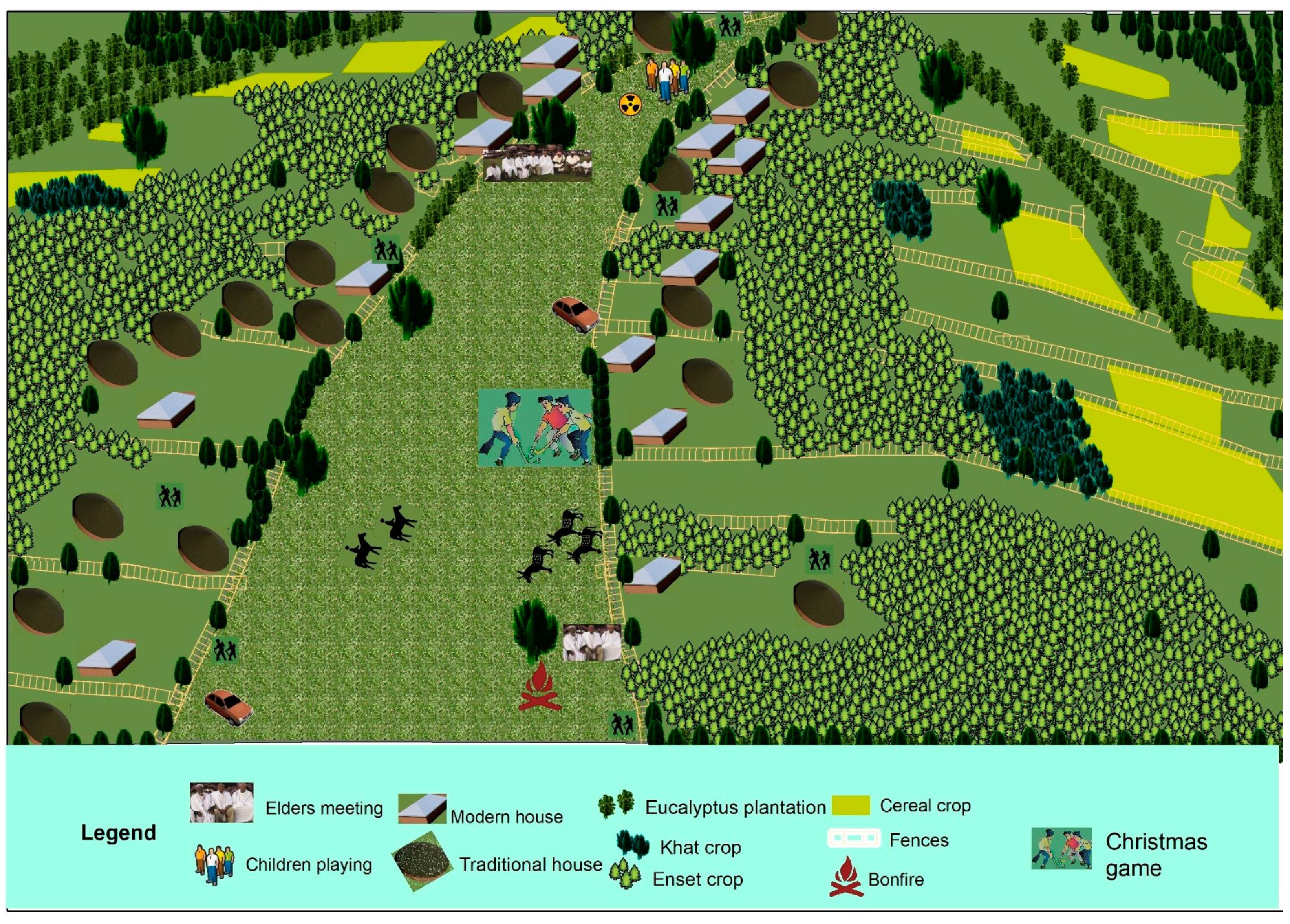
Jefoure roads can serve as a natural transport mode for a long time with continuous management. The community’s primary motivation for allocating part of the landscape for a Jefoure road is to enable free physical access for humans and livestock (see Figure 2 and Figure S1). Jefoure roads have a considerable breadth, ranging from 5 to 87 m, with an average of 23 ± 8 m, and can extend 20 km without stopping. Long-distance travelers mainly prefer Jefoure roads with an extensive breadth and long length. The short-distance Jefoure roads appear as tree branches connecting villages to the main Jefoure road. The smaller-width and short-distance roads parallel to and between other Jefoure roads support shortcut movements between Jefoure roads on foot. Furthermore, some roads enable accessibility of resources, such as water streams or grazing land. When vehicles were introduced to the landscape, the Jefoure roads began to serve as off-road routes that connected many villages.
According to informants, livestock such as horses, donkeys, sheep, and cattle would be fastened with long ropes or children would herd livestock while playing in Jefoure roads (Figure 2). The grass-cover Jefoure road, especially during the wet season, serves as a nutrition source for livestock. The geospatial data extracted from orthophotos indicate that Jefoure roads cover more than 11,283 ha of the Gurage socio-ecological production landscape. Considering the average amount of dry matter for pasture lands in Ethiopia, all Jefoure roads could produce approximately 60,928 tons of dry matter in a single wet season. Because the region has bimodal rainfall, Jefoure areas could yield more than 100,000 tons of dry matter per year.
Jefoure land use supports community livelihoods by facilitating spaces for growing fuelwood and timber along fences. Plant species on the left and right sides of a Jefoure road range from shrubs to large vascular plants, such as Eucalyptus spp. Eucalyptus spp. species can currently be observed in areas ranging from lowlands to mountain tops. Eucalyptus trees addressed firewood shortages and are a significant source of timber for constructing houses and fences.
According to the informants and field observations, the Gurage people in highland areas use horses for threshing their cereal crops (see Figure S2). A large circle of well-drained and green-covered ground forms the threshing floor. They often use Jefoure areas as a threshing floor because large farmers cannot find places suitable for threshing floors, with flat, compacted soil, green covers, and access to winds, on their parcel of land.

3.1.2. Nonmaterial NCP by Jefoure Roads

Over time, Jefoure roads enable the community to practice social and cultural activities such as spiritual and religious practices (e.g., bonfire during Meskel festivals), local judicial services, marriage and mourning ceremonies, and use as playgrounds (see Figure 2 and Figure S2). Besides referring to a traditional road style that cuts through two parallel settlements, the word “Jefoure” is also used by the community to refer to the lowest level of a geographical unit where people are settled under the shade of the old-growth trees. Jefoure areas have long been used as places for community elders to conduct judicial services. The selected places in the Jefoure roads are used to conduct meetings and festivals of clans and sub-clans, such as Yejoka. Many governmental or non-governmental organization-based training and workshops are currently conducted in Jefoure areas by following the elders, which are used for knowledge-sharing. The participants are comfortable during such meetings, enjoying ambient-air conditions under the shade of trees. It is a fact that the authors conducted some of the key informant interviews and FDGs under trees in Jefoure roads.
Jefoure roads have long served as religious and spiritual places highly respected in traditional belief systems and Christianity. Even though the practices have faded, the traditional religious followers believed in deities with supernatural powers handed to them by the Supreme God, Egzer. Even though mass worship was practiced in sacred shrines in forest groves, some people had sacred trees. These trees are found along with Jefoure roads and are locally called Adbar trees for worshiping their Supreme God; thus, they are highly valued and nobody can cut them. Among the Christian community, a bonfire is prepared in the Jefoure area as part of the Meskel festival (the finding of the true cross) in Ethiopia. This event is known as Demera, which UNESCO inscribes as an intangible heritage. The preferable site in villages is nearest to the trees if big trees are available on the Jefoure road.
Jefoure areas have long been an essential landscape for building social relationships among communities. Previously, the marriage request and engagement was arranged by the agreement of the families. According to informants, road accessibility is a criterion for getting easy acceptance of the bride’s family’s request. At most, the brides’ homes would be long-distance, and travel between them took place on the Jefoure road. The Jefoure roads would allow for holding horse competitions among the bride’s friends and obtaining a free and relaxed journey. The Gurage people have a mourning ceremony, known as Werko, which is held when a respected person in the community dies. According to informants, a large and flat area is required to hold such a ceremony, which Jefoure areas provide. After the burial, the ceremony continues for three successive days in the respective villages. The community does not use tents to stay outside, and people use the shade of trees on Jefoure roads.
Jefoure roads are a shared community resource used equally by all age groups, from children to elders. According to the informants, the most enjoyable places for children and youth are Jefoure, where most children and youths spend their leisure time. Because these places are used for open grazing, it is also possible to exercise through play while herding livestock. The youths play football in the Jefoure roads by constructing small pitches using local materials, as they are the only nearby open area. According to survey participants, a traditional game, known as Zore, is played by children in Jefoure roads during August and September. Another traditional game is Yegenna Chewata (Christmas game), a traditional Ethiopian game similar to field hockey, played during the Christmas season. Horse competitions are one of the oldest sports in the region, and youths compete during events and at regular times on the Jefoure roads. Horses are trained in Jefoure roads, and children learn riding skills there as well. Kurfwa is a traditional dance performed by young girls in some localities; this particular dance resembles mourning the death of Jesus Christ during Easter and is performed in Jefoure roads.
In the Jefoure roads, community elders perform simple exercises, such as walking, sitting to rest, refreshment, and chatting with colleagues. Among the community, some youths and elders chew fresh leaves of khat (a stimulant crop); near the trees in Jefoure areas are the preferred sites for sitting. According to the informants, many youths go to towns for work and education, returning during annual festivals, such as Meskel and Eid al-Adha. The places most enjoyed by immigrants and visitors are the Jefoure roads; most often, they spend their time on Jefoure roads.
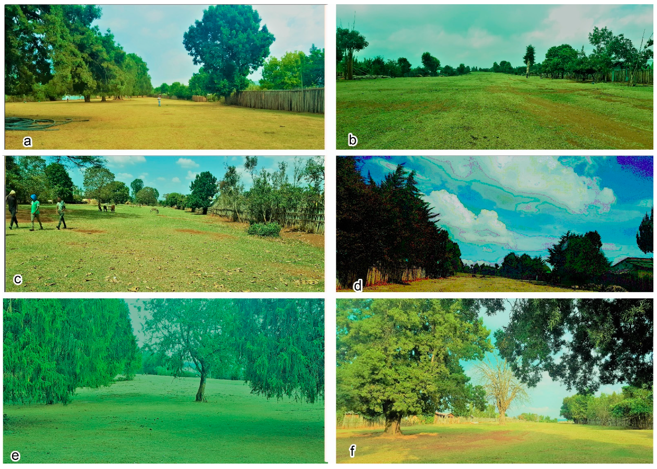
The Jefoure roads, designed in parallel, and covered with grasses, structured fences, vernacular houses, and scatted trees, contribute to community feelings of a sense of place and allows the community to distinguish themselves from other groups (Figure 3). According to the informants, one of the most significant contributions to making a personal attachment to living in their locality is the Jefoure roads. Informants living in well-designed Jefoure roads do not want to change their given parcel of land. People feel at home in their villages when they observe such an environment. The Jefoure-based settlement pattern has been developed through the community’s ancestor wisdom on landscape architecture knowledge and experiences. Young informants thought that they appreciate the efforts of their ancestors and felt proud. Additionally, the elders felt that Jefoure areas are important places that must be preserved irrespective of their use for future generations.

3.1.3. Regulating NCP by Jefoure Roads

The grass-covered Jefoure roads with their hosting vascular trees and side fences also can regulate local temperature, climate, water flow, and soil erosion (Figure 3). Jefoure roads are one of the ecosystems in the Gurage socio-ecological production landscape that can provide habitats for the remaining vascular plant species to protect them from degradation. Large trees still survive on the Jefoure roads because they are used for cultural purposes, and illegal clearing is not usual on Jefoure roads. We recorded 21 species in the case study sites, and the most frequently existing species at diverse localities include Podocarpus falcatus, Croton macrostachyus, Millettia ferruginea, Cordia africana, Juniperus procera, and Olea europaea. The DBH of the trees is 4–195 cm with an average of 44 ± 21 cm. In the case study, the average number of trees per Jefoure road, without considering the road length and width, is 21 and there are 1.5 trees/ha on average. Thus, based on the extrapolation, more than 22,780 trees are expected in the Gurage landscape’s Jefoure roads. Diverse species are planted by household fences along Jefoure roads, including shrubs and large trees used for fencing and material purposes. Even though many trees with many diverse species are not conserved on Jefoure roads, they still preserve rare species in Ethiopia. According to the informants, the trees in the Jefoure roads provide shade for sitting. This shade provides places to conduct meetings, settle conflicts, and spend leisure time with various groups of people (see Figure 2; Figure 3 and Figure S2).
The number of trees found in Jefoure roads ranges from zero in the highlands to 95 in lowland Jefoure areas, such as Cheret. The largest single tree in Jefoure can store 15.07 tons of above and below-ground carbon, removing 55.3 tons of CO2 from the atmosphere. On average, a single tree in Jefoure areas stores 0.78 tons of above and below-ground carbon for a CO2 equivalent of 2.85 tons. Based on extrapolation, the Jefoure roads trees store 13,633.7 tons of carbon. Even though there is a variation in soil organic carbon depending on land management, the same authors estimated 95.1 ± 64 tons ha−1 of carbon in the grazing land in the Wabe River catchment within the landscape. Because Jefoure areas are covered with grass and used as grazing land, approximately 1,073,013 tons of carbon can be stored in the existing Jefoure areas. In total, approximately 1,090,698 tons of carbon is available in the Western Gurage landscape Jefoure roads, which would contribute to offsetting proximate to four million tons of CO2 in the atmosphere. Additionally, large numbers of trees with diverse species exist along Jefoure roads as fences. These trees can significantly contribute to climate change mitigation much better than the trees on Jefoure roads.
According to the informants, overland water flow during the rainy season can be excessive in the Gurage socio-ecological production landscape. However, the runoff discharged from Jefoure roads looks clean compared to the overland flow from agricultural lands and degraded areas. In contrast, the amount of runoff and sediment content is high in localities where poor-quality gravel roads were constructed on existing Jefoure roads. Because Jefoure roads exist in upland areas, while agricultural lands on the left and right sides exist on lower landscapes, water in the saturated soil can flow to agricultural lands during the dry season. This surface flow contributes to vegetation growth and agricultural production since most communities do not use an irrigation system.

3.2. Perceived Changes and Trends of NCP Use by Jefoure Roads

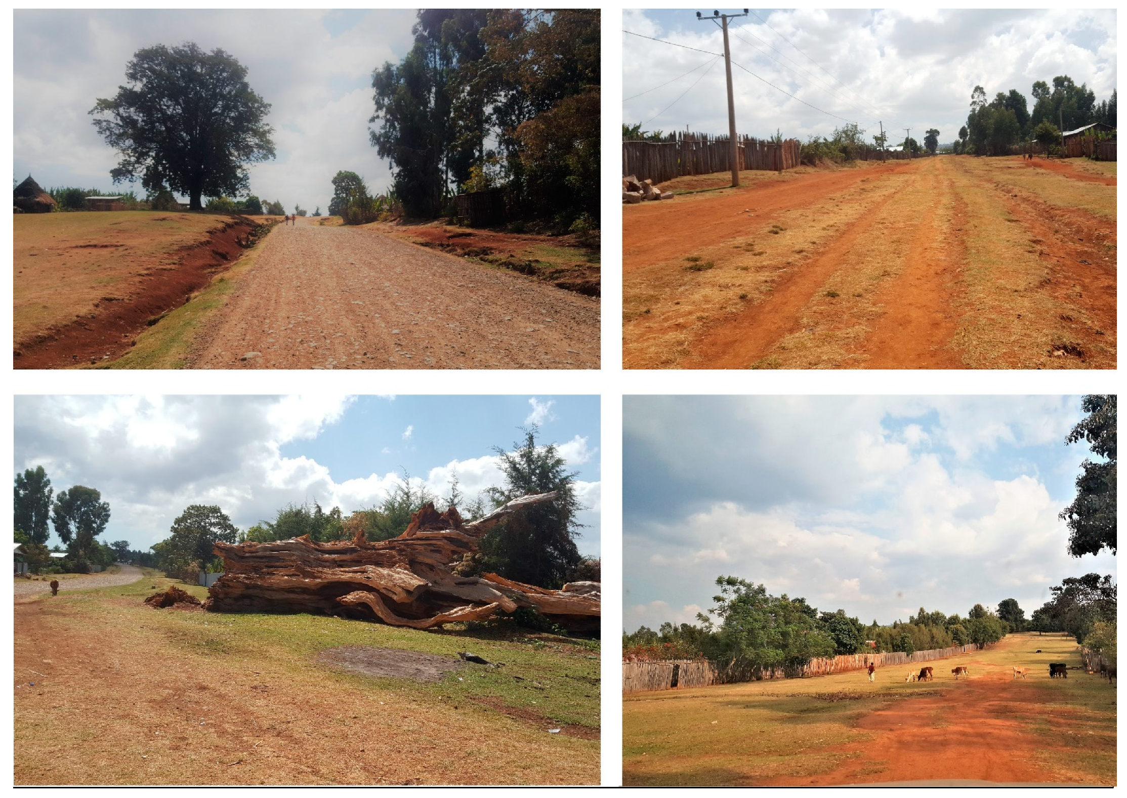
According to this study’s data collection tools, some of the longest Jefoure roads have been shortened or narrowed by road constructions. This is a result of the low-standard paved roads, which are under construction on Jefoure roads in several parts of the landscape, either initiated by government organizations or the community (Figure 4). In the localities where the roads are constructed, erosion can easily be caused by heavy rainfall. Consequently, stormwater can flow beyond the ditches. Another change observed in the Jefoure roads is the degradation caused by soil erosion. Some of the Jefoure roads located in the middle of the landscape catchment, such as in Mihurena Aklil, Ezha, Cheha, and Enemoherna Ener districts, are degraded because of the soil erosion caused by water from natural factors and anthropogenic activities. The problems are aggravated by road construction, particularly in areas with easily erodible soil properties and terrain areas.
In some localities, infrastructure provisions lead to the narrowing of the extent, reducing the scenic beauty of Jefoure roads. The poorly designed facilities, such as water points, schools, animal and human health clinics, agricultural extension program offices, and farmer training centers are built at inappropriate locations in the Jefoure roads. Frequently, the facilities occupy larger areas than needed, reducing the excellent quality of the Jefoure roads. The scattered trees are most often old-growth and Indigenous trees, which are unable to replicate. These trees are falling due to age, and are also felled by the community to discourage traditional believers and road construction. According to the informants, some farmers include parts of the Jefoure road in their farmlands, in villages with inefficient social rules and regulations. In these localities, farmers use parts of the Jefoure road for cereal crops or eucalyptus plantations.
The trend for the past 50 years in the case study shows that the NCP use at different localities has been decreasing (see Table S5). Traditional religious practices have faded in all localities. In villages where conventional roads have been constructed, the contributions, such as local temperature, climate, and water-flow regulation, have been decreasing because of the removal of an important ecology. In such localities, interactions with villages on the opposite side decrease, children cannot play without risks, and the aesthetic quality and scenic beauty of the cultural landscape reduce. There is no change in access to Jefoure roads for humans and livestock or holding Christianity-oriented practices in all localities. The use of Jefoure roads for vehicle transportation has increased in all localities. For a long time, Jefoure roads have served as places to enhance mental and physical health and continue as recreational and ecotourism destinations. Currently, even though only some children and youths play traditional games, such as Zore, Yegenna Chewata, and horse competition, the Jefoure roads still play a significant role in mental and physical health, recreation, and ecotourism.

4. Discussion

4.1. NCP by Roads

Roads affect both the biotic and abiotic components of landscapes, including hydrology, mechanics of sediment and debris transport, air chemistry, microclimate, and levels of noise, wind, and light adjacent to the roadsides [35]. Indirectly, the roads’ development and presence can reduce the landscape permeability, leading to habitat loss and fragmentation increase [20,22]. However, roads may not always have adverse ecological effects; for example, roads such as greenways and unpaved terrenes have minimal impacts. Recently, NCP concerning road verges were systematically reviewed, and it was concluded that well-managed road verges provide positive ecological effects for highways and roads in agricultural landscapes [23]. Local communities manage landscapes through their customary institutions and enhance biodiversity by formulating multifunctional road landscapes. The traditional roads such as Jefoure are beyond transport access and they support human well-being by enabling material, nonmaterial, and regulating NCP. Further investigations on the NCP assessment of roads in different regions are essential to enhance the understanding of land-use planners and decision-makers, helping them to integrate the NCP concept in the planning and management of road networks.

4.2. Indigenous and Local Knowledge Recognitions

Many countries are rich in natural and cultural heritage values in daily life, and provide authoritative and socially cohesive power to live [36]. Local knowledge for rural and Indigenous peoples informs them to develop social, cultural, and ecological assets, including socio-ecological production landscapes [37]. These unique ways of knowing are essential components of the world’s cultural diversity and contribute to sustainable development. However, much of this knowledge is under threat, mainly due to changing socio-cultural values, globalization, and lack of legal bounds [38]. With the pace of development, vast numbers of cultural landscapes, archaeological sites, and others are lost each year. In Agenda 21, the primary document of the 1992 Earth Summit in Rio de Janeiro, Indigenous peoples are acknowledged as playing a vital role in environmental management and development because of their traditional knowledge and practices [37]. In the same year, the World Heritage Convention became the first international legal instrument to recognize and protect cultural landscapes developed or evolved by Indigenous and local knowledge of several generations [39]. However, recognition and respect for the contribution of Indigenous and local knowledge to the conservation and sustainable use of biodiversity and nature is still not well organized and becomes one of the operational principles in IPBES [2,13,37,40]. Approaches in working with Indigenous, local, and scientific knowledge in assessments of nature and nature’s linkages with people are under development [13]. As noted by [3], context-specific NCP and knowledge co-production with Indigenous and local people need to be implemented, and the methodological development and practical operational guidance for NCP assessments are encouraged to be advanced.
Roads influence the settings and are usually considered part of the landscape. Therefore, roads can contribute to the expressivity, integrity, and permanency of precious cultural landscapes. The nonmaterial NCP are mainly associated with the history, religion, and other assets of the communities living in particular areas. The traditional roads, such as Jefoure, cannot be preserved by themselves, and conservation planning is required along with other cultural aspects, particularly in socio-ecological production landscapes. The recognition of cultural roads as heritage sites could promote sustainable planning and management.

4.3. Sustaining NCP in Jefoure Roads

The Gurage socio-ecological production landscape with the Jefoure roads is a continually evolving landscape, closely related to traditional ways of life. The local community designed the Jefoure roads without prior knowledge of landscape architecture by following the natural topographic features. However, as outlined in the result section, the roads are facing challenges, and some of the management options for sustaining the diverse NCP provisions to the local community are:
  • Maintaining the existing Jefoure roads using suitable surfacing materials in locations not accessible to vehicles or in parts of the roads in which it is required
  • A cross-sectional route selection of the newly constructed roads along with the existing parallel Jefoure roads as an option to safeguard the landscape
  • Implementing appropriate soil and water conservation in the degraded areas to improve the transit between villages and sustain the Jefoure roads
  • Appropriate site selection for public and social facilities, which potentially compromise the delivery of a diverse NCP
  • Planting Indigenous tree species in sparse or not available Jefoure areas, besides conserving the existing trees on or along the roads
  • Sharing experiences among the communities for improving the quality and uniformity of the Jefoure road management
  • Selection of tourist destination sites using efficient criteria such as breadth, long-distance with a straight shape, extensive grass-cover, satisfactory side fences, scattered trees, well-constructed traditional houses, and places where historical events occurred.

5. Conclusions

This study focused on the assessment of NCP provisions, specifically on grass-covered traditional roads. Roads in a socio-ecological production landscape, including Jefoure roads, provide evidence of the socio-cultural and political conditions in which they were constructed. This study revealed that diverse NCP provisions in cultural roads are supplied by the roads and surrounding natural and cultural environments. Therefore, understanding, supporting, and promoting local communities’ cultural assets are essential to managing the demands of NCP provisions related to roads. A comprehensive NCP assessment comparable with the Jefoure roads can enhance local communities, stakeholders, planners, and decision makers’ knowledge for sustainable management. The sustainability of cultural roads in future development can be achieved by integrating Indigenous knowledge into planning and continuously updating without degradation. Attempts to merge aesthetics, visual issues, human needs, and ecological aspects are encouraged to be included in future road constructions. The involvement of residents, local groups, land-use planners, and decision-makers are needed to sustainably manage cultural roads. Because roads influence the global economy and everyday life, stopping road network development is unrealistic. This study prompts planners and decision-makers to reduce roads’ negative ecological impacts and identify solutions for protecting and enhancing NCP according to landscape type. The approach used in this study is a bottom-up approach, focused on the subjective and contextual contributions of the landscape to people’s quality of life, and the methods can be applied in similar studies. Furthermore, this study contributes to the understanding of traditional and Indigenous knowledge for future IPBES global assessments.

Supplementary Materials

The following are available online at https://www.mdpi.com/article/10.3390/su13073806/s1, Table S1: Sample data collection localities in the western Gurage socio-ecological production landscape, Table S2: Sample interviewed participants profile in selected Jefoure roads, Table S3: Sample focus group discussions participants profile in selected Jefoure roads, Table S4: Reporting categories of NCP with the indicator for assessment by Jefoure roads, Figure S1: The Gurage socio-ecological landscape settlement pattern following the Jefoure roads, Figure S2: Socio-cultural practices that take place on Jefoure roads, and Table S5: Trends in the uses of ecosystem services in different Jefoure roads.

Author Contributions

Conceptualization, M.S.; methodology, M.S.; software, M.S.; validation, M.S. and O.S.; formal analysis, M.S.; investigation, M.S.; resources, O.S.; data curation, M.S.; writing—original draft preparation, M.S.; writing—review and editing, O.S.; visualization, M.S.; supervision, O.S.; project administration, O.S.; funding acquisition, O.S. All authors have read and agreed to the published version of the manuscript.

Funding

Financial support was obtained from the Japan Society for the Promotion of Science for overseas researchers.

Institutional Review Board Statement

Not applicable.

Informed Consent Statement

Informed consent was obtained from all subjects involved in the study.

Data Availability Statement

The data presented in this study are available, upon request, from the corresponding author.

Acknowledgments

This study’s key interviews and FDGs were conducted with the kind cooperation of the Gurage Zone Tourism and Culture office and Wolkite University in Ethiopia. The Japan Society for the Promotion of Science for the overseas researchers supported this study in finance. The United Nations University Institute for the Advanced Study of Sustainability and Institute for Global Environmental Strategies in Japan provided logistic supports. We greatly acknowledge these organizations.

Conflicts of Interest

The authors declare no conflict of interest.

References

  1. Millennium Ecosystem Assessment (MA). Ecosystems and Human Well-Being: A Framework for Assessment; Island Press: Washington, DC, USA, 2005. [Google Scholar]
  2. Díaz, S.; Pascual, U.; Stenseke, M.; Martin-Lopez, B.; Watson, R.T.; Molnár, Z.; Hill, R.; Chan, K.M.; Baste, I.A.; Brauman, K.A.; et al. Assessing nature’s contributions to people. Science 2018, 359, 270–272. [Google Scholar] [CrossRef] [Green Version]
  3. Andrew, N.K.; María, D.L.; Jacob, A.; Nils, D.; Hyeonju, R.; Giovanni, Á.; Solen, L.C.; Marcia, C.M.; Lovisa, N.; Sakshi, R.; et al. Disentangling ‘ecosystem services’ and ‘nature’s contributions to people’. Ecosyst. People 2019, 15, 269–287. [Google Scholar] [CrossRef] [Green Version]
  4. Peterson, G.D.; Harmáčková, Z.V.; Meacham, M.; Queiroz, C.; Jiménez-Aceituno, A.; Kuiper, J.J.; Malmborg, K.; Sitas, N.; Bennett, E.M. Welcoming different perspectives in IPBES: “Nature’s Contribution to People” and “ecosystem services”. Ecol. Soc. 2018, 23. [Google Scholar] [CrossRef]
  5. Japan Satoyama Satoumi Assessment (JSSA). Satoyama-Satoumi Ecosystems and Human Wellbeing: Socio-Ecological Production Landscapes of Japan (Summary for Decision-Makers); United Nations University: Tokyo, Japan, 2010. [Google Scholar]
  6. Takeuchi, K. Rebuilding the relationship between people and nature: The Satoyama initiative. Ecol. Res. 2010, 25, 891–897. [Google Scholar] [CrossRef] [Green Version]
  7. Saito, O.; Subramanian, S.M.; Hashimoto, S.; Takeuchi, K. (Eds.) Introduction: Socio-ecological Production Landscapes and Seascapes. In Managing Socio-Ecological Production Landscapes and Seascapes for Sustainable Communities in Asia; Science for Sustainable Societies; Springer: Singapore, 2020. [Google Scholar] [CrossRef] [Green Version]
  8. Foley, J.A.; DeFries, R.; Asner, G.P.; Barford, C.; Bonan, G. Global consequences of land use. Science 2005, 309, 570–574. [Google Scholar] [CrossRef] [PubMed] [Green Version]
  9. Raudsepp-Hearne, C.; Peterson, G.D.; Bennett, E.M. Ecosystem service bundles for analyzing tradeoffs in diverse landscapes. Proc. Natl. Acad. Sci. USA 2010, 107, 5242–5247. [Google Scholar] [CrossRef] [Green Version]
  10. Smith, F.P.; Gorddard, R.; House, A.P.N.; McIntyre, S.; Prober, S.M. Biodiversity and agriculture: Production frontiers as a framework for exploring trade-offs and evaluating policy. Environ. Sci. Policy 2012, 23, 85–94. [Google Scholar] [CrossRef]
  11. Parrott, L.; Meyer, W.S. Future landscapes: Managing within complexity. Front. Ecol. Environ. 2012, 10, 382–389. [Google Scholar] [CrossRef] [Green Version]
  12. Rabbinge, R.; Bindraban, P.S. Making more food available: Promoting sustainable agricultural production. J. Integr. Agric. 2012, 11, 1–8. [Google Scholar] [CrossRef]
  13. Hill, R.; Adem, C.; Alangui, W.V.; Molnár, Z.; Aumeeruddy-Thomas, Y.; Bridgewater, P.; Tengö, M.; Thaman, R.; Yao, C.Y.A.; Berkes, F.; et al. Working with indigenous, local and scientific knowledge in assessments of nature and nature’s linkages with people. Curr. Opin. Environ. Sustain. 2020, 43, 8–20. [Google Scholar] [CrossRef]
  14. Orlovic Lovren, V. Traditional and Indigenous Knowledge: Bridging Past and Future Sustainable Development. In Life on Land. Encyclopedia of the UN Sustainable Development Goals; Leal Filho, W., Azul, A., Brandli, L., Özuyar, P., Wall, T., Eds.; Springer: Cham, Switzerland, 2019. [Google Scholar] [CrossRef]
  15. Emily, M.; Irwin, F.; Ranganathan, J.; Hanson, C.; Kousky, C.; Bennett, K.; Ruffo, S.; Conte, M.; Salzman, J.; Paavola, J. Incorporating ecosystem services in decisions. In Natural Capital: The Theory and Practice of Mapping Ecosystem Services; Kareiva, P., Ricketts, T., Daily, G., Tallis, H., Polasky, S., Eds.; Oxford University Press: Oxford, UK, 2011. [Google Scholar] [CrossRef]
  16. Farina, A. The cultural landscape as a model for the integration of ecology and economics. Bioscience 2000, 50, 313–320. [Google Scholar] [CrossRef] [Green Version]
  17. Gos, P.; Lavorel, S. Stakeholders’ expectations on ecosystem services affect the assessment of ecosystem services hotspots and their congruence with biodiversity. Int. J. Biodivers. Sci. Ecosyst. Serv. Manag. 2012, 8, 93–106. [Google Scholar] [CrossRef]
  18. Moran-Ordonez, A.; Bugter, R.; Suarez-Seoane, S.; Luis, E.; de Calvo, L. Temporal changes in socio-ecological systems and their impact on ecosystem services at different governance scales: A case study of heathlands. Ecosystem 2013, 16, 765–782. [Google Scholar] [CrossRef]
  19. Grübler, A. Technology. In Changes in Land use and Land Cover: A Global Perspective; Meyer, W.B., Turner, B.L., II, Eds.; Cambridge University Press, with Clark University: Cambridge, UK, 1994; pp. 287–328. [Google Scholar]
  20. Ariel, E.; Gucinski, L.H. Function, effects, and management of forest roads. Forest Ecol. Manag. 2000, 133, 249–262. [Google Scholar] [CrossRef]
  21. Grazuleviciute-Vileniske, I.; Matijosaitiene, I. Cultural Heritage of Roads and Road Landscapes: Classification and Insights on Valuation. Landsc. Res. 2010, 35, 391–413. [Google Scholar] [CrossRef]
  22. Coffin, A.W. From roadkill to road ecology: A review of the ecological effects of roads. J. Transp. Geogr. 2007, 15, 396–406. [Google Scholar] [CrossRef]
  23. Phillips, B.B.; Bullock, J.M.; Osborne, J.L.; Gaston, K.J. Ecosystem service provision by road verges. J. Appl. Ecol. 2020, 57, 488–501. [Google Scholar] [CrossRef]
  24. Sahle, M.; Saito, O.; Furst, C.; Yeshitela, K. Quantification and mapping of the supply of and demand for carbon storage and sequestration service in woody biomass and soil to mitigate climate change in the socio-ecological environment. Sci. Total Environ. 2018, 624, 342–354. [Google Scholar] [CrossRef]
  25. Sahle, M.; Yeshitela, K.; Saito, O. Mapping the supply and demand of Enset crop to improve food security in Southern Ethiopia. Agron. Sustain. Dev. 2018, 38, 7. [Google Scholar] [CrossRef] [Green Version]
  26. Sahle, M.; Saito, O.; Furst, C.; Yeshitela, K. Quantifying and mapping of water-related ecosystem services for enhancing the nexus of food-water-energy security in data-sparse regions of tropics. Sci. Total Environ. 2019, 646, 573–586. [Google Scholar] [CrossRef] [PubMed]
  27. Aneseyee, A.B.; Elias, E.; Soromessa, T.; Feyisa, G.L. Land use/land cover change effect on soil erosion and sediment delivery in the Winike watershed, Omo Gibe Basin, Ethiopia. Sci. Total Environ. 2020, 728, 138776. [Google Scholar] [CrossRef] [PubMed]
  28. Yirga, D.; Abera, M.; Kebede, G.; Kifle, S. The Gurage and its cultural values. In The Gurage Culture; Tourism and Communication Office: Amharic: Sidamo, Ethiopia, 2012. [Google Scholar]
  29. Shack, W.A. The Gurage: A People of the Enset Culture. African Ethnographic Studies of the 20th Century 59; Oxford University Press: Oxford, UK, 1966. [Google Scholar]
  30. Central Statistical Agency (CSA). Population and House Census Report of Ethiopia; Central Statistical Agency (CSA): Addis Ababa, Ethiopia, 2009. [Google Scholar]
  31. Ethiopian Mapping Agency (EMA). Aerial Photography Quality Control. SLMP South Block 1 and 2 Projects; Ethiopian Mapping Agency (EMA): Addis Ababa, Ethiopia, 2017. [Google Scholar]
  32. Brown, S. Estimating Biomass and Biomass Change of Tropical Forests: A Primer; FAO Forestry Paper–134; FAO: Rome, Italy, 1989; pp. 120–130. [Google Scholar]
  33. MacDicken, K. A Guide to Monitoring Carbon Storage in Forestry and Agroforestry Projects; Winrock International: Arlington, TX, USA, 1997. [Google Scholar]
  34. Intergovernmental Panel on Climate Change (IPCC). IPCC Guidelines for National Greenhouse Gas Inventories; National Greenhouse Gas Inventories Program, IGES: Hayama, Japan, 2006. [Google Scholar]
  35. Bennett, V.J. Effects of Road Density and Pattern on the Conservation of Species and Biodiversity. Curr. Landsc. Ecol. Rep. 2017, 2, 1–11. [Google Scholar] [CrossRef]
  36. UNESCO. Operational Guidelines for the Implementation of the World Heritage Convention. Intergovernmental Committee for the Protection of the World Cultural and Natural Heritage; UNESCO World Heritage Centre 7; UNESCO: Paris, France, 2015. [Google Scholar]
  37. UNESCO. Local Knowledge, Global Goals; UNESCO: Paris, France, 2017; p. 48. [Google Scholar]
  38. Ahsan Ullah, A.K.M.; Yit Ho, H.M. Globalization and Cultures in Southeast Asia: Demise, Fragmentation, Transformation. Glob. Soc. 2020. [Google Scholar] [CrossRef]
  39. UNESCO. Convention Concerning the Protection of the World Cultural and Natural Heritage; World Heritage Committee: Santa Fe, NM, USA, 1992. [Google Scholar]
  40. Pascual, U.; Balvanera, P.; Díaz, S.; Pataki, G.; Roth, E.; Stenseke, M.; Watson, R.T.; Başak Dessane, E.; Islar, M.; Kelemen, E.; et al. Valuing Nature’s Contributions to People: The IPBES approach. Curr. Opin. Environ. Sustain. 2017, 26–27, 7–16. [Google Scholar] [CrossRef] [Green Version]
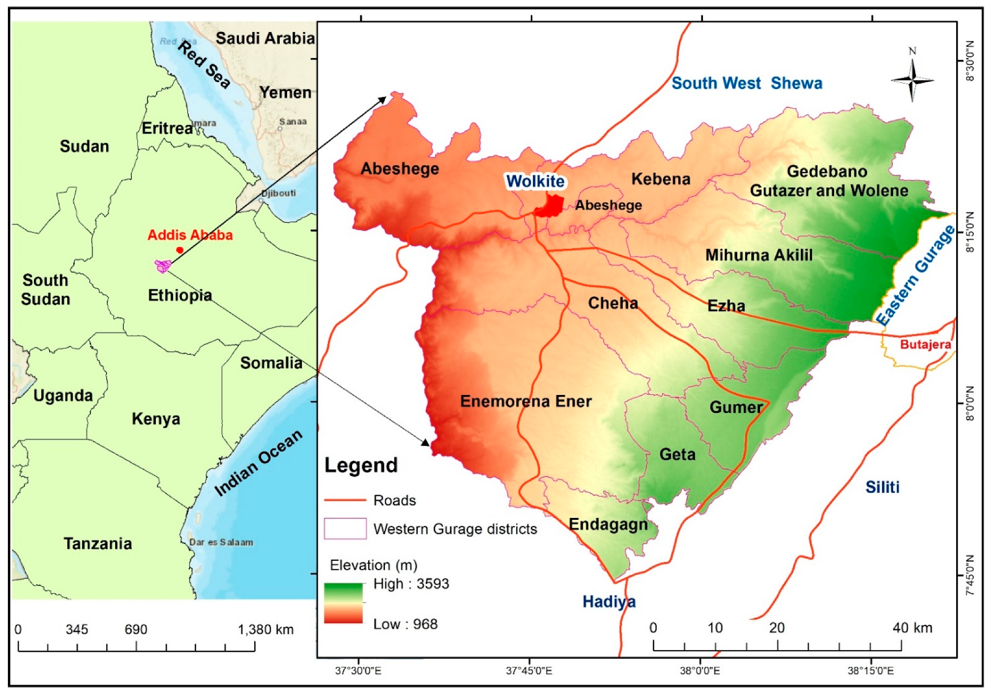
Figure 1. Map of the Western Gurage socio-ecological production landscape in Ethiopia.
Sustainability 13 03806 g001
Figure 2. Illustrations of Jefoure roads in the Gurage socio-ecological production landscape.
Sustainability 13 03806 g002
Figure 3. An overview of the selected Jefoure roads sites: (a) Inagera, (b) Selam, (c) Cheret, (d) Aegera, (e) Yadazer Yezhira, (f) Gehared (field survey, February 2020).
Sustainability 13 03806 g003
Figure 4. Perceived changes in the landscape mainly by road constructions.
Sustainability 13 03806 g004
Publisher’s Note: MDPI stays neutral with regard to jurisdictional claims in published maps and institutional affiliations.