
The Synergy of Ecosystems of Blue and Green Infrastructure and Its Services in the Metropolitan Area—Chances and Dangers


Abstract
1. Introduction
1.1. Synergy as a Word Concept for Urban Ecosystems
1.2. Ecosystems and Their Importance for Urban Areas
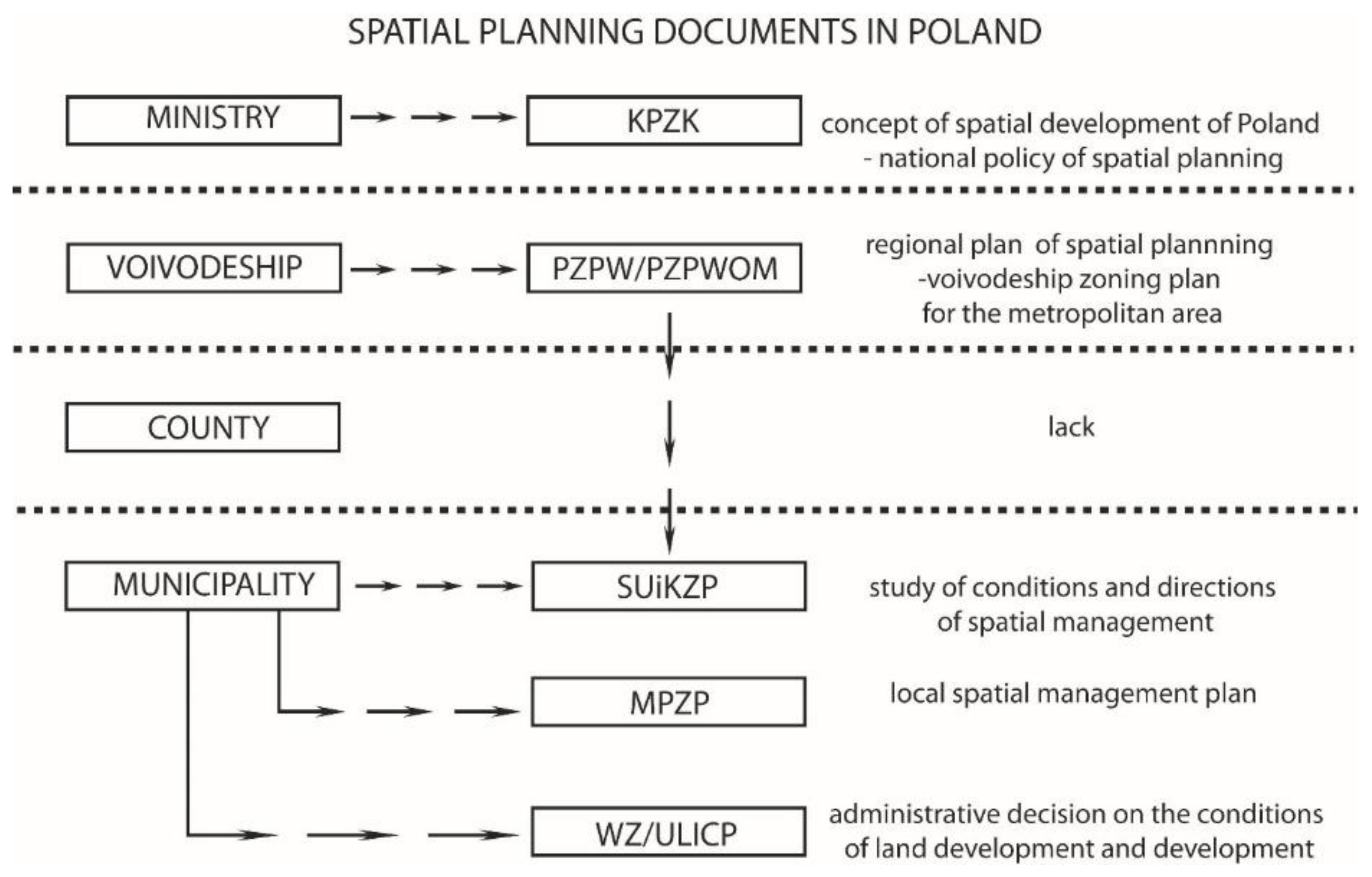
2. Materials and Methods
- single patches, spatial landscape elements;
- ”least common geometric unit” is generated automatically in GIS by superimposing maps of different components;
- administrative units;
- sub-catchments of rivers (or higher-order);
- natural units (soil, vegetation, etc.);
- landscape units;
- regular artificial geometric units (e.g., raster mesh).

2.1. Ecosystem Services and Their Importance in Terms of Blue Infrastructure
2.2. The Method of Analysis in the Aspect of Environmental Value—Obtaining and Compiling Municipality Data
3. Results
4. Discussion
5. Conclusions
Author Contributions
Funding
Institutional Review Board Statement
Informed Consent Statement
Data Availability Statement
Conflicts of Interest
References
- Grilli, G.; Jonkisz, J.; Ciolli, M.; Lesinski, J. Mixed Forests and Ecosystem Services: Investigating Stakeholders’ Perceptions in a Case Study in the Polish Carpathians. For. Policy Econ. 2016, 66, 11–17. [Google Scholar] [CrossRef]
- Zhang, J.; Yin, N.; Wang, S.; Yu, J.; Zhao, W.; Fu, B. A Multiple Importance–Satisfaction Analysis Framework for the Sustainable Management of Protected Areas: Integrating Ecosystem Services and Basic Needs. Ecosyst. Serv. 2020, 46, 101219. [Google Scholar] [CrossRef]
- Karimi, A.; Yazdandad, H.; Fagerholm, N. Evaluating Social Perceptions of Ecosystem Services, Biodiversity, and Land Management: Trade-Offs, Synergies and Implications for Landscape Planning and Management. Ecosyst. Serv. 2020, 45, 101188. [Google Scholar] [CrossRef]
- Damania, R.; Fredriksson, P.G.; List, J.A. The Multiplier Effect of Globalization. Econ. Lett. 2004, 83, 285–292. [Google Scholar] [CrossRef]
- Derlatka, A. Synergia Jako Kryterium Ocenyprojektów Rewitalizacji Śródmieść. Bud. Archit. 2017, 16, 19–28. [Google Scholar] [CrossRef]
- Belbin, R.M. Chapter 2—The Apollo syndrome. In Management Teams, 3rd ed.; Belbin, R.M., Ed.; Butterworth-Heinemann: Oxford, UK, 2010; pp. 13–23. ISBN 978-1-85617-807-5. [Google Scholar]
- Myers, N.D.; Prilleltensky, I.; Hill, C.R.; Feltz, D.L. Well-being self-efficacy and complier average causal effect estimation: A substantive-methodological synergy. Psychol. Sport Exerc. 2017, 30, 135–144. [Google Scholar] [CrossRef]
- Bolund, P.; Hunhammar, S. Ecosystem Services in Urban Areas. Ecol. Econ. 1999, 29, 293–301. [Google Scholar] [CrossRef]
- Urban Agenda for the EU. Available online: https://ec.europa.eu/futurium/en/urban-agenda (accessed on 27 January 2021).
- Feledyn-Szewczyk, B. Bioróżnorodność Jako Wskaźnik Monitorowania Stanu Środowiska. Studia Rap. IUNG PIB 2016, 47, 105–124. [Google Scholar] [CrossRef]
- Solon, J.; Roo-Zielinska, E.; Affek, A.; Kowalska, A.; Kruczkowska, B.; Wolski, J.; Degórski, M.; Grabińska, B.; Kołaczkowska, E.; Regulska, E.; et al. Świadczenia Ekosystemowe w Krajobrazie Młodoglacjalnym. In Ocena Potencjału i Wykorzystania [Ecosystem Services in a Postglacial Landscape. Assessment of Potential and Utilisation]; Wydawnictwo Akademickie SEDNO: Warsaw, Poland, 2017; ISBN 978-83-7963-062-2. [Google Scholar]
- Document. Available online: https://bip.malopolska.pl/uglapanow,a,197387,uchwala-nr-vii4403-rady-gminy-lapanow-z-dnia4lipca-2003-r-w-sprawie-uchwaleniamiejscowego-planu-zago.html (accessed on 23 January 2021).
- Document. Available online: https://www.dobczyce.pl/sites/default/files/upload/uchwala_xviii.110.16_bienkowice_dz.urz_.pdf (accessed on 20 January 2021).
- Document. Available online: http://www.gdow.e-mpzp.pl/tekst/XXXVI_249_2017_ror.pdf (accessed on 20 January 2021).
- Hrehorowicz-Gaber, H. Contemporary Changes, and Development of Spatial Structures in the Carpathians. Conditions and Development Models. Cracow University of Technology: Cracow, Poland, 2019. [Google Scholar]
- Coutts, C.; Hahn, M. Green Infrastructure, Ecosystem Services, and Human Health. Int. J. Environ. Res. Public Health 2015, 12, 9768–9798. [Google Scholar] [CrossRef]
- Blazy, R. Living Environment Quality Determinants, Including PM2.5 and PM10 Dust Pollution in the Context of Spatial Issues—The Case of Radzionków. Buildings 2020, 10, 58. [Google Scholar] [CrossRef]
- Haashemi, S.; Weng, Q.; Darvishi, A.; Alavipanah, S.K. Seasonal Variations of the Surface Urban Heat Island in a Semi-Arid City. Remote Sens. 2016, 8, 352. [Google Scholar] [CrossRef]
- Fromm, O. Ecological Structure and Functions of Biodiversity as Elements of Its Total Economic Value. Environ. Resour. Econ. 2000, 16, 303–328. [Google Scholar] [CrossRef]
- Riechers, M.; Strack, M.; Barkmann, J.; Tscharntke, T. Cultural Ecosystem Services Provided by Urban Green Change along an Urban-Periurban Gradient. Sustainability 2019, 11, 645. [Google Scholar] [CrossRef]
- Solon, J. Koncepcja “Ecosystem Services” i jej zastosowania w badaniach ekologiczno-krajobrazowych. Probl. Ekol. Krajobrazu 2008, 21, 28–30. [Google Scholar]
- McCauley, D.J. Selling out on nature. Nature 2006, 443, 27–28. [Google Scholar] [CrossRef] [PubMed]
- Costanza, R.; de Groot, R.; Sutton, P.; van der Ploeg, S.; Anderson, S.J.; Kubiszewski, I.; Farber, S.; Turner, R.K. Changes in the global value of ecosystem services. Glob. Environ. Chang. 2014, 26, 152–158. [Google Scholar] [CrossRef]
- Kronenberg, J. Betting against Human Ingenuity: The Perils of the Economic Valuation of Nature‘s Services. BioScience 2015, 65, 1096–1099. [Google Scholar] [CrossRef]
- Bjornstad, D.J.; Kahn, J.R. (Eds.) The Contingent Valuation of Environmental Resources; Edward Elgar: Cheltenham, UK, 1996. [Google Scholar]
- Kronenberg, J. Usługi Ekosystemów—Nowe Spojrzenie na Wartość Środowiska Przyrodniczego; Wydawnictwo Uniwersytetu Łódzkiego: Łódź, Poland, 2016; ISBN 978-83-7969-576-8. [Google Scholar]
- De Groot, R.S.; Wilson, M.A.; Boumans, R.M.J. A typology for the classification, description and valuation of ecosystem functions, goods and services. Ecol. Econ. 2002, 41, 393–408. [Google Scholar] [CrossRef]
- Convention on Biological Diversity (CBD). 1992. Available online: https://www.cbd.int/ (accessed on 20 January 2021).
- The EU Biodiversity Strategy to 2020. Available online: https://ec.europa.eu/environment/nature/biodiversity/strategy_2020/index_en.html (accessed on 27 January 2021).
- Dubel, A. Comparative analysis of methods of environmental vaulation. case study of błonia krakowskie. Prace Naukowe Uniw. Ekon. Wroc. 2017, 122–131. [Google Scholar] [CrossRef]
- Atkinson, G. Environmental valuation and benefits transfer. In Cost-Benefit Analysis and Incentives in Evaluation. The Structural Funds of the European Union; Florio, M., Ed.; Edward Elgar Publishing: Cheltenham, UK, 2006. [Google Scholar]
- Landers, D.H.; Nahlik, A.M. Final Ecosystem Goods and Services Classification System (FEGS-CS)(EPA/600/R-13/ORD-004914); US Environmental Protection Agency, Office of Research and Development: Washington, DC, USA, 2013. [Google Scholar]
- Mikołajczyk, P. Mapowanie i Ocenaekosystemów i Ich Usług w Polsce. UNEP GRID—Warszawa, 7 October 2015. [Google Scholar]
- Pueyo-Ros, J. The Role of Tourism in the Ecosystem Services Framework. Land 2018, 7, 111. [Google Scholar] [CrossRef]
- Dancewicz, A. Pole Opadów Atmosferycznych w Otoczeniu Sztucznych Zbiorników Wodnych Otmuchów i Nysa Przed i Po Ich Powstaniu. Wiad. Inst. Meteorol. Gospod. Wodnej 1993, XVI, 70–85. [Google Scholar]
- Hall, D.K.; Frei, A.; DiGirolamo, N.E. On the frequency of lake-effect snowfall in the Catskill Mountains. Phys. Geogr. 2018, 39, 389–405. [Google Scholar] [CrossRef] [PubMed]
- Matuszko, D. Próba określenia wpływu zbiornika wodnego na zachmurzenie i usłonecznienie (na przykładzie Zbiornika Dobczyckiego). In Rola Stacji Terenowych w Badaniach Geograficznych; Instytut Geografii i Gospodarki Przestrzennej Uniwersytetu Jagiellońskiego: Kraków, Poland, 2005; pp. 79–91. [Google Scholar]
- Available online: https://www.nbp.pl/home.aspx?f=/dzienne/stopy.html (accessed on 5 January 2021).
- Costanza, R.; d’Arge, R.; De Groot, R.; Farber, S.; Grasso, M.; Hannon, B.; Limburg, K.; Naeem, S.; O’neill, R.V.; Paruelo, J. The Value of the World’s Ecosystem Services and Natural Capital. Nature 1997, 387, 253–260. [Google Scholar] [CrossRef]
- Knoke, T.; Gosling, E.; Paul, C. Use and Misuse of the Net Present Value in Environmental Studies. Ecol. Econ. 2020, 174, 106664. [Google Scholar] [CrossRef]
- Guerry, A.D.; Ruckelshaus, M.H.; Arkema, K.K.; Bernhardt, J.R.; Guannel, G.; Kim, C.-K.; Marsik, M.; Papenfus, M.; Toft, J.E.; Verutes, G.; et al. Modeling benefits from nature: Using ecosystem services to inform coastal and marine spatial planning. Int. J. Biodivers. Sci. Ecosyst. Serv. Manag. 2012, 8, 107–121. [Google Scholar] [CrossRef]
- Yemshanov, D.; McCarney, G.R.; Hauer, G.; Luckert, M.M.; Unterschultz, J.; McKenney, D.W. A real options-net present value approach to assessing land use change: A case study of afforestation in Canada. For. Policy Econ. 2015, 50, 327–336. [Google Scholar] [CrossRef]


| Bio-Diversity | Quantity | Quality |
|---|---|---|
| ecosystem brand | range and range of species of communities | The variety of ecosystems and communities |
| species brand | species richness | Species differentiation, equality |
| genetic brand | mutations | Allele variability in the gene pool and gene exchange |
| Assessment Method | Assessed Ecosystem Services | Advantages of the Method | Method Limitations | Comments |
|---|---|---|---|---|
| Market prices | Only valid for the market | Market data readily available and reliable | Limited to market-related services | They set the lower limit of values, do not include subsidies, do not take into account useless values |
| Replacement costs | They depend on the existence of the real estate market placeholders | Market data readily available and reliable | It is possible to overestimate the value | For example, the costs of building flood embankments |
| Costs of hedonistic behavior | Services that affect air quality and visual-aesthetic values | Market data readily available and reliable | A huge amount of data is required, often missing and limited to land ownership | The price of the property is influenced by the natural features of the place, its quality, and environmental hazards |
| Travel costs | Services that affect the recreational value of a place | It is based on observations and surveys | It is just for recreational benefits. Trips with multiple destinations and destinations are not included. | The cost incurred by a tourist to arrive at a given place (travel, overnight) is a measure of the recreational value. |
| Service According to FEGS | Description of the Benefit | Type of Ecosystem Providing the Service | Potential Indicators | Pool/Resource Indicators | Supply Indicators | Assessment Possible Based on Existing Data |
|---|---|---|---|---|---|---|
| 00.0601 | Cultural: Tourist site | Lagoon | 25.27 € 2 | 107,589 (number of accomodations 1) | 27,187.74 € | Low error threshold |
| 00.0801 | Cultural: Educational cruise on the reservoir | Lagoon | 32.97 € 4 | 28,800 persons 3 | 949,536.00 € | Low error threshold |
| 00.0205 | Supply: Electricity production | Lagoon | 0.12 € 5 | 9.6 GWh 6 | 1,160,401.44 € | Low error threshold |
| 31 | Regulating: Influence on water circulation and insolation | Lagoon | 0.12 € 5 | 11 kWh 7 | (+224.83 €) 8 | Low error threshold |
| Wartość | Łapanów | Gdów | Dobczyce |
|---|---|---|---|
| Price 1 per 1 m2 of a plot of land or land in a commune in the Małopolskie Voivodeship | 8.57 €/m2 | 12.74 €/m2 | 16.70 €/m2 |
| Change in prices of plots of land or land in the commune in the Małopolskie Voivodeship in the last 12 months | 11% | −8% | 124% |
| Average plot or land value 1 in a commune in the Małopolskie Voivodeship | 23,020.34 € | 41,129.32 € | 71,232.25 € |
| Number of plots or land for sale in the commune in the Małopolskie Voivodeship | 62 | 64 | 10 |
| Average area plot or land in the commune in the Lesser Poland Voivodeship | 2942 m2 | 3703 m2 | 5189 m2 |
| Average price 1 of an agricultural plot per 1 ar | 3.95 € | 3.29 € | 8.79 € |
| Average house value 1 | 109,847.45 € | 109,847.45 € | 118,635.25 € |
| Łapanów | Gdów | Dobczyce | |
|---|---|---|---|
| MPZP/act of a local law change | Resolution amending: Local Plan No. XIX/140/2012—3.49 km2 1 | Resolution No. XXXVI/249/2017 of the Gdów Commune Council of 8 June 2017—1.013 km2 | Resolution No. XXVI/164/16 of the City Council of Dobczyce —12.940 km2 |
| Agricultural plots | 35 ha | 12.10 ha | 502.08 ha |
| building plots | 69.64 ha | 165.01 ha | 233.73 ha |
| Water ecosystem blue infrastructure | 3.5 ha | 16.55 ha | 140.00 ha |
| Alluvial green infrastructure | 68.76 ha | 19.11 ha | 65.54 ha |
| recreation green infrastructure | 5 ha | 53.73 ha | 18.45 ha |
| forest green infrastructure | 23.48 ha | 4.5 ha | 20.35 ha |
| Name of the Water Reservoir | Area (ha) | Max. Depth. (m) | Impact 1 | Genesis | Text in MPZP 2 | Text in SUIKZP 2 | Condition | Ratio Area (%) 3 |
|---|---|---|---|---|---|---|---|---|
| Bagry (Kraków) | 31.4 | 10.0 | yes (Kraków) | Post-industrial excavation flooded | no protection | protection | = | 1.3 8 |
| Balaton (Trzebinia) | 3.0 | 9.5 | yes | flooded quarry-drinking water reservoir | no protection | protection | ↓ | 0.02 |
| Chechelskie Lake | 54 | No data | no | A dam reservoir | no protection | protection | No data | 0.5 |
| Czorsztyńskie Lake | 1100.0 | 50.0 | no | A dam reservoir | no protection | protection | ↓ | 0.05 |
| Dąbski Pond | 2.54 | No data | yes (Kraków) | Post-industrial excavation flooded | ecological area | protection | = | 1.38 |
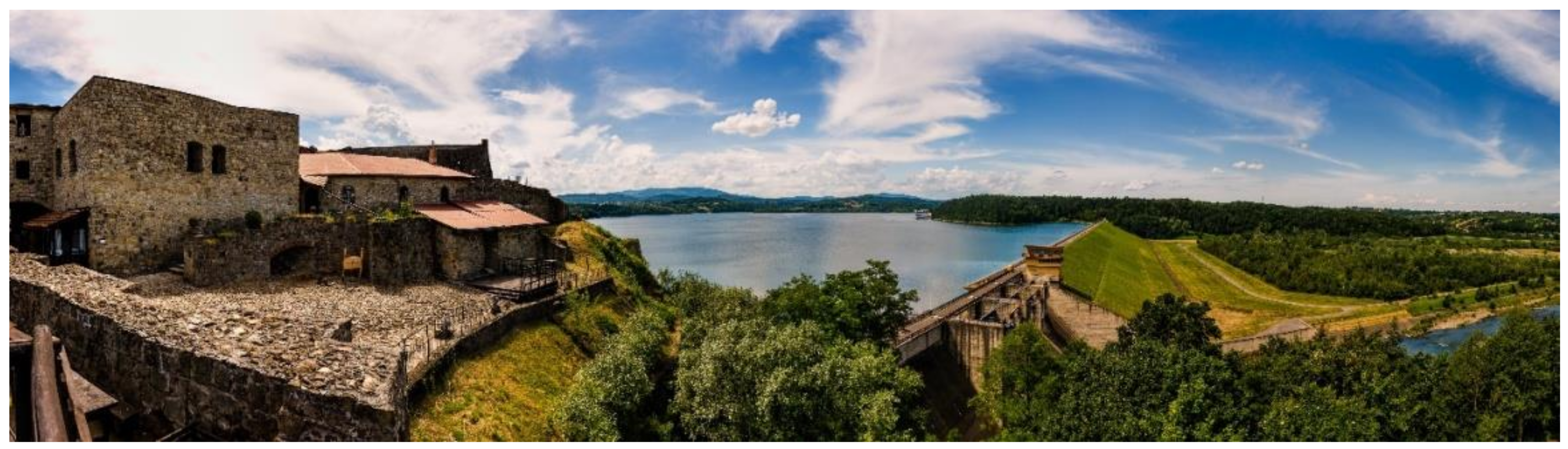
| Dobczyckie Lake | 1065.0 | 28.0 | yes | A dam reservoir | no protection | protection | ↑ | 16.0 7 |
| Gdow-Nieznanowice | 16.55 | No data | yes | Post-industrial excavation flooded | Protection | protection | = | No data |
| Klimkowskie Lake | 310.0 | 25.0 | no | A dam reservoir | no protection | protection | = | 1.0 |
| Kryspinów Lagoon | 1500.0 | 8.0 | Yes 5 | No data | no protection | protection | ↑ | Not specified 6 |
| Łapanów Lagoon | 3.5 | No data | yes | A dam reservoir | no protection | protection | ↓ | No data |
| Mucharskie Lake | 1035.0 | 50.0 4 | no | A dam reservoir | no protection | protection | No data | 13.0 |
| Nowohucki Lagoon | 7.0 | 2.5 | yes (Kraków) | Recreational reservoir | no protection | protection | ↓ | 1.3 8 |
| Płaszowski Pond | 7.9 | No data | yes (Kraków) | Post-industrial excavation flooded | no protection | protection | = | 13.0 8 |
| Przylasek Rusiecki (lake reservoirs) | 0.0086 | No data | yes (Kraków) | Natural oxbow of the Vistula | no protection | protection | ↓ | 1.3 8 |
| Rożnowskie Lake | 1600.0 | 35.0 | no | A dam reservoir | Protection | protection | ↓ | 4.5 |
| Zakrzówek Lagoon | 23.0 | 32.0 | yes (Kraków) | Flooded quarry | ecological area | protection | ↑ | 1.3 8 |
| Zesławicki Lagoon | No data | No data | yes 5 | Post-industrial excavation flooded | no protection | protection | ↓ | Not specified 6 |
| The Average Price of an Agricultural Plot [€] per m2 | The Average Price of an Undeveloped Building Plot [€] Per m2 | The Price of Building [€] | |
|---|---|---|---|
| Łapanów | 3.95 | 8.57 | 109,906.20 |
| Gdów | 3.29 | 12.74 | 109,906.20 |
| Dobczyce | 8.79 | 16.70 | 118,698.70 |
| CFt 1 | CF0 2 | NPV 3 | |
|---|---|---|---|
| Łapanów | 5,130,228,433.03 € | 277,056,043.31 € | 3,489,118,707.36 € |
| Gdów | 15,105,062,302.82 € | 543,828,778.80 € | 10,545,547,414.64 € |
| Dobczyce | 277,634,186,789.86 € | 2,056,663,606.55 € | 201,795,942,848.67 € |
| NPV | Ve | NPVe | Financial Difference Taking into Account the Coefficient Ve | |
|---|---|---|---|---|
| Łapanów | 3,489,118,707.36 € | 0.19 | 4,152,051,261.76 € | 662,932,554.40 € |
| Gdów | 10,545,547,414.64 € | 0.03 | 10,861,913,837.08 € | 316,366,422.44 € |
| Dobczyce | 201,795,942,848.67 € | 0.32 | 266,370,644,560.24 € | 64,574,701,711.57 € |
Publisher’s Note: MDPI stays neutral with regard to jurisdictional claims in published maps and institutional affiliations. |
© 2021 by the authors. Licensee MDPI, Basel, Switzerland. This article is an open access article distributed under the terms and conditions of the Creative Commons Attribution (CC BY) license (http://creativecommons.org/licenses/by/4.0/).
Share and Cite
Blazy, R.; Hrehorowicz-Gaber, H.; Hrehorowicz-Nowak, A.; Płachta, A. The Synergy of Ecosystems of Blue and Green Infrastructure and Its Services in the Metropolitan Area—Chances and Dangers. Sustainability 2021, 13, 2103. https://doi.org/10.3390/su13042103
Blazy R, Hrehorowicz-Gaber H, Hrehorowicz-Nowak A, Płachta A. The Synergy of Ecosystems of Blue and Green Infrastructure and Its Services in the Metropolitan Area—Chances and Dangers. Sustainability. 2021; 13(4):2103. https://doi.org/10.3390/su13042103
Chicago/Turabian StyleBlazy, Rafał, Hanna Hrehorowicz-Gaber, Alicja Hrehorowicz-Nowak, and Arkadiusz Płachta. 2021. "The Synergy of Ecosystems of Blue and Green Infrastructure and Its Services in the Metropolitan Area—Chances and Dangers" Sustainability 13, no. 4: 2103. https://doi.org/10.3390/su13042103
APA StyleBlazy, R., Hrehorowicz-Gaber, H., Hrehorowicz-Nowak, A., & Płachta, A. (2021). The Synergy of Ecosystems of Blue and Green Infrastructure and Its Services in the Metropolitan Area—Chances and Dangers. Sustainability, 13(4), 2103. https://doi.org/10.3390/su13042103