
Thermal Inequity in Richmond, VA: The Effect of an Unjust Evolution of the Urban Landscape on Urban Heat Islands

 ,
, 
 , and
, and
Abstract
1. Introduction
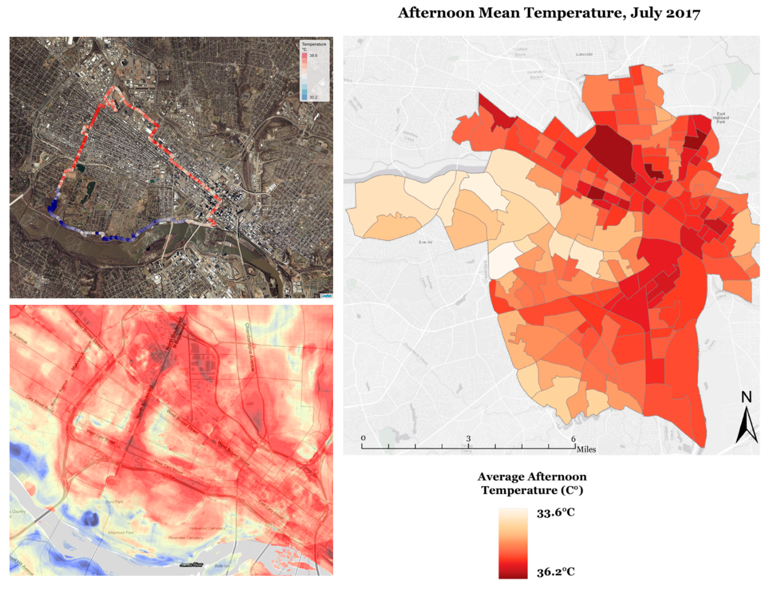
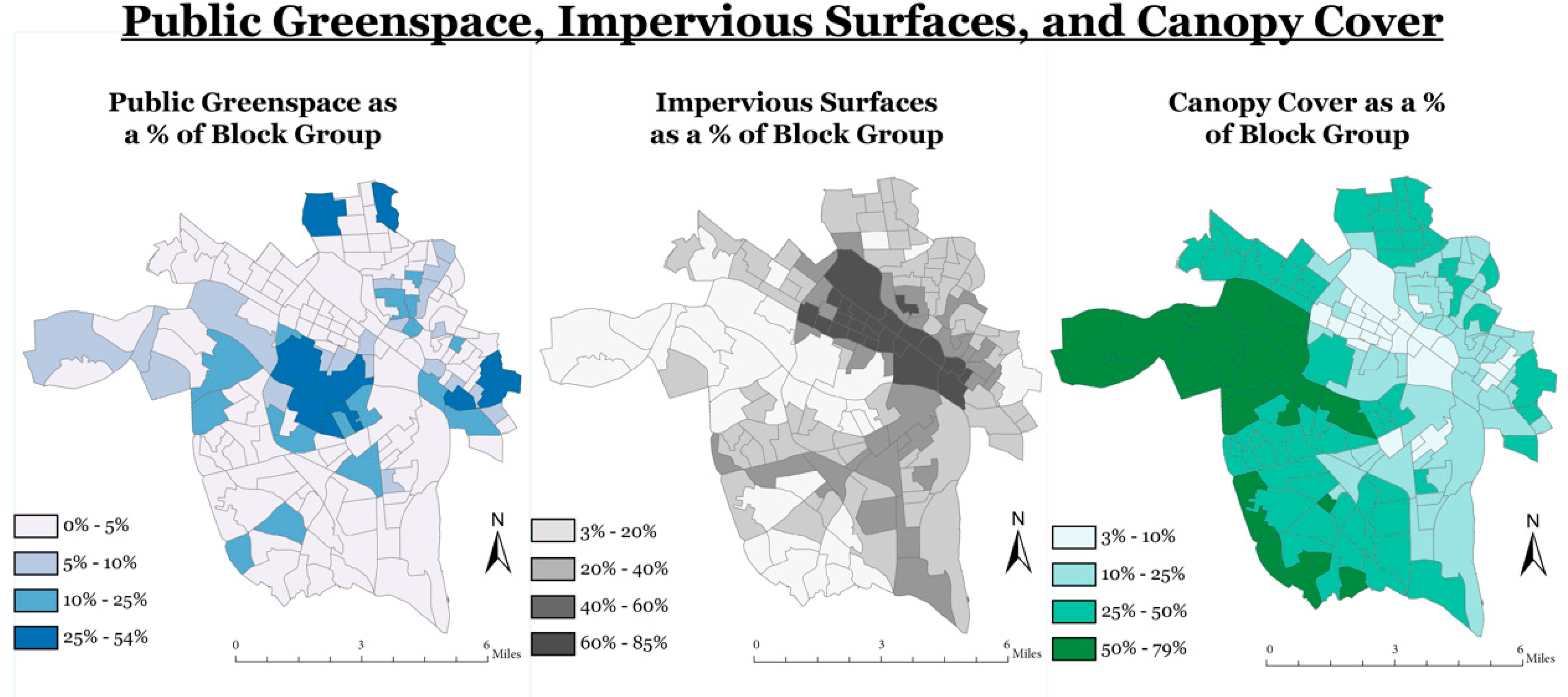
2. Materials and Methods
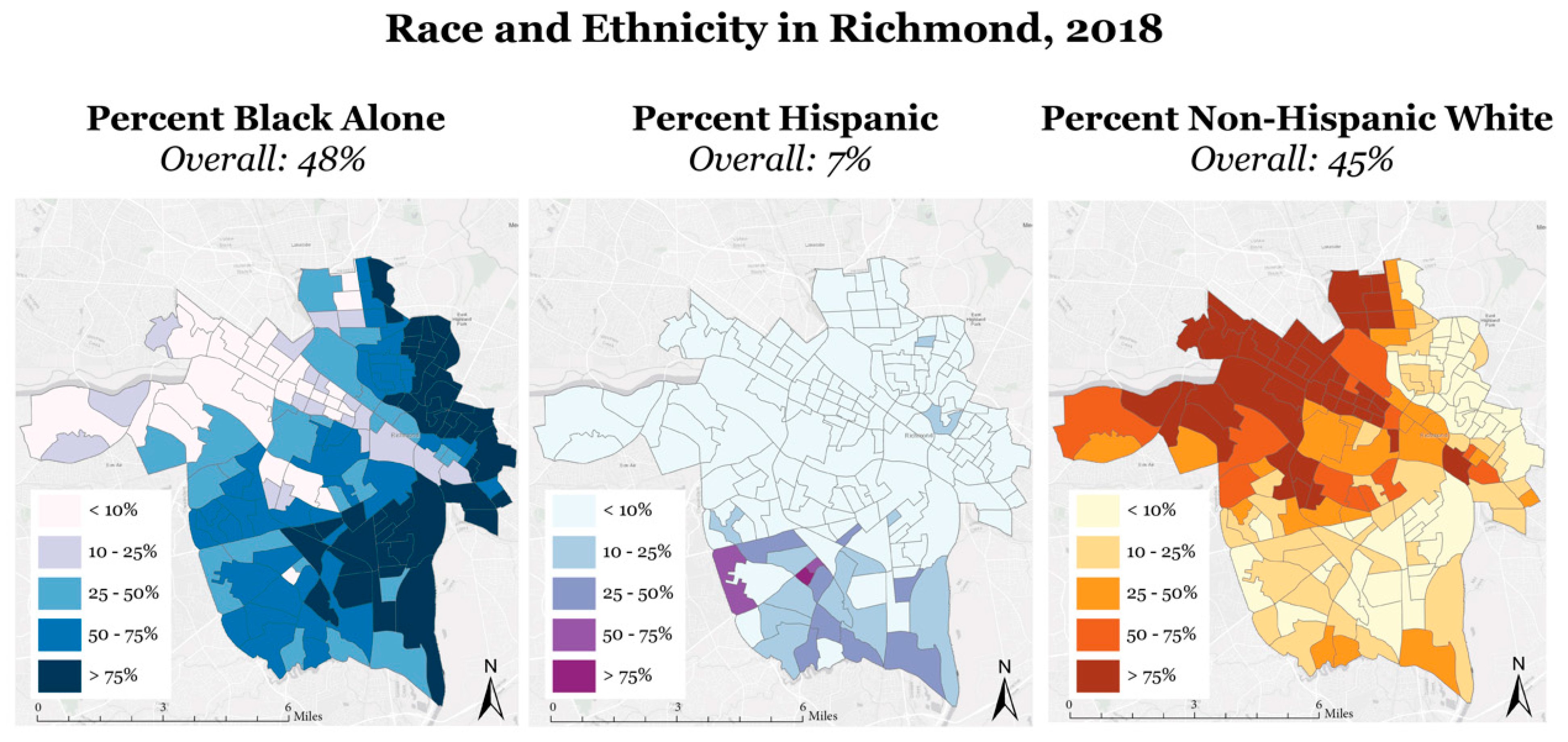
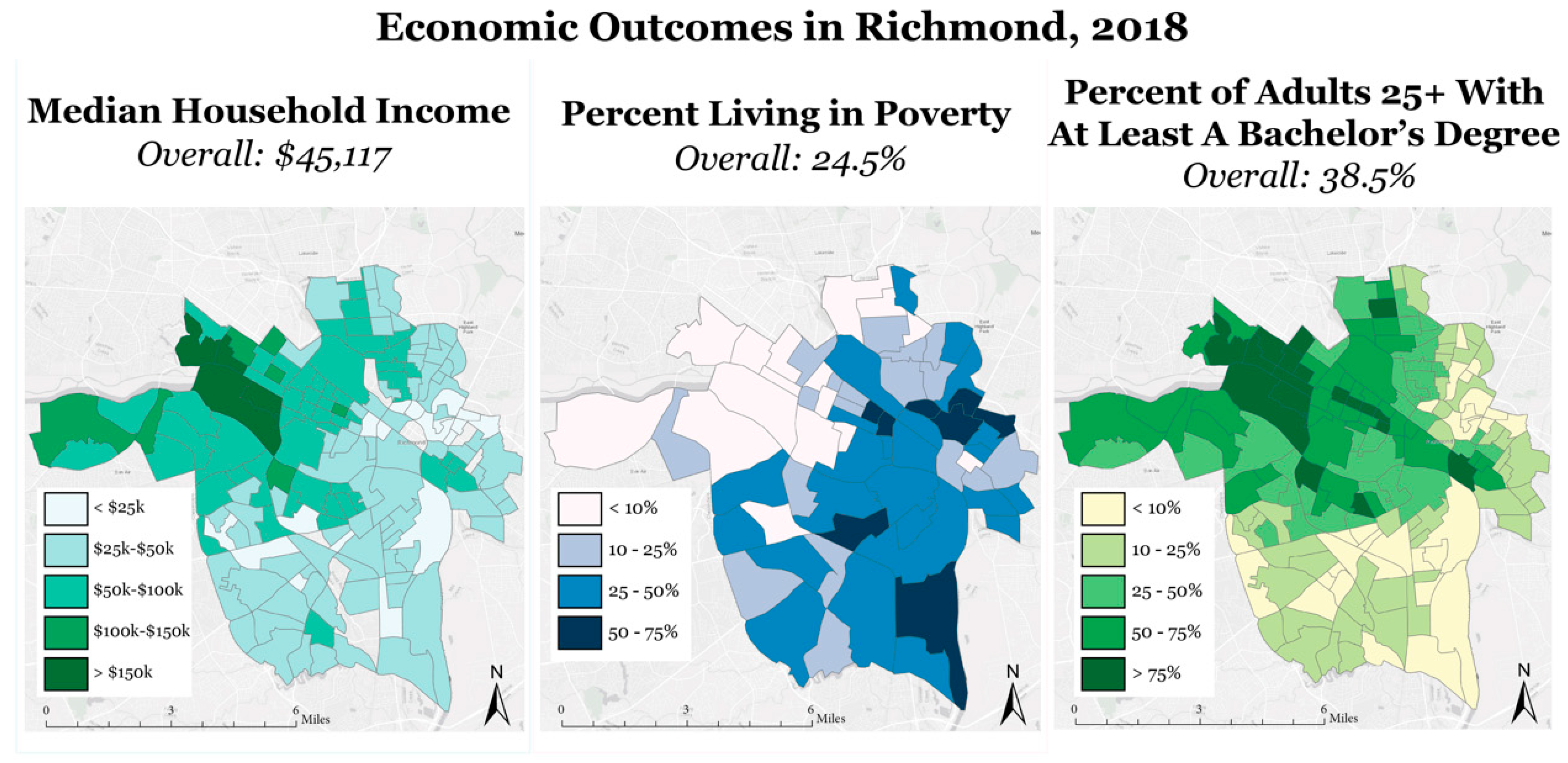
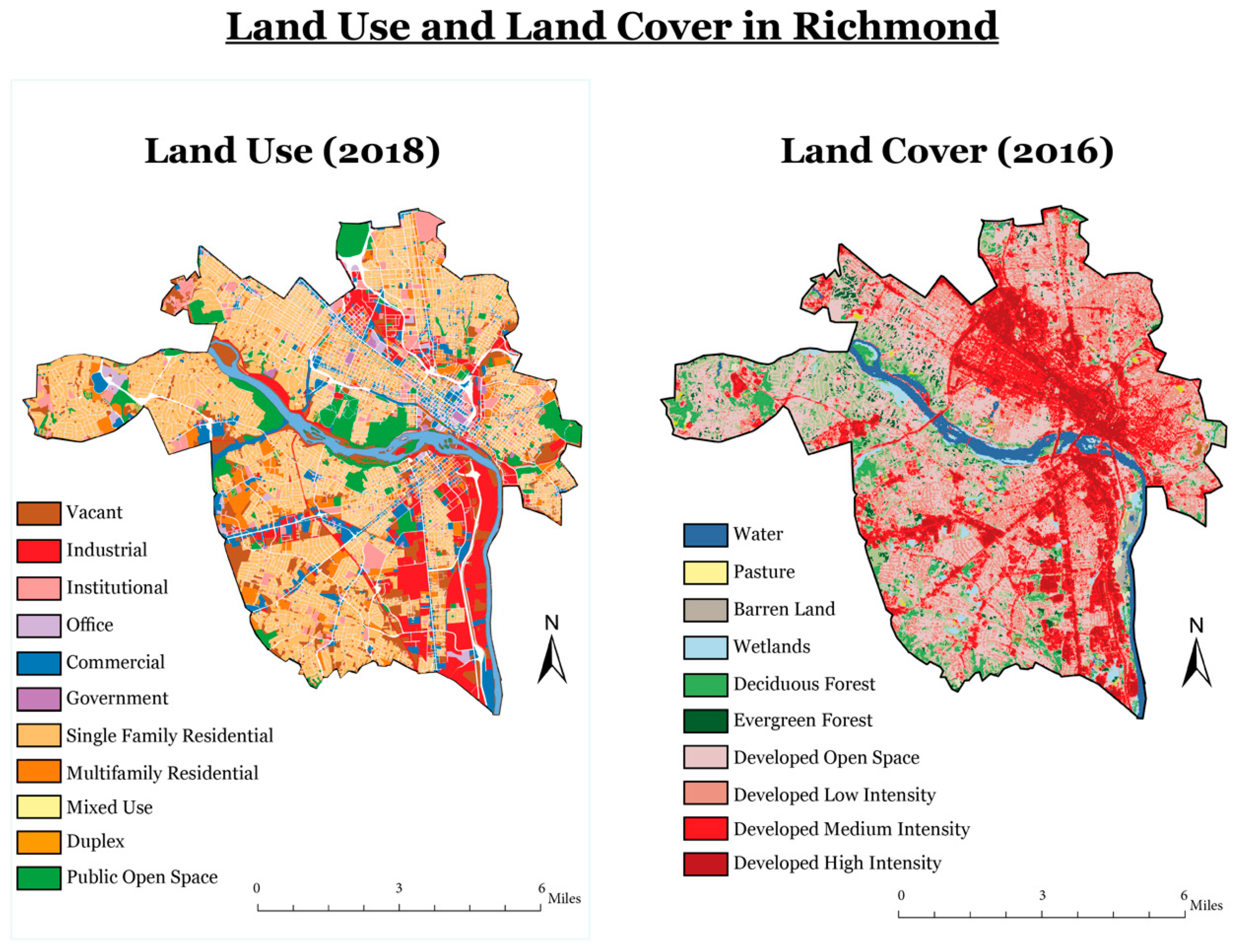
2.1. Study Area
2.2. Data
2.3. Analysis
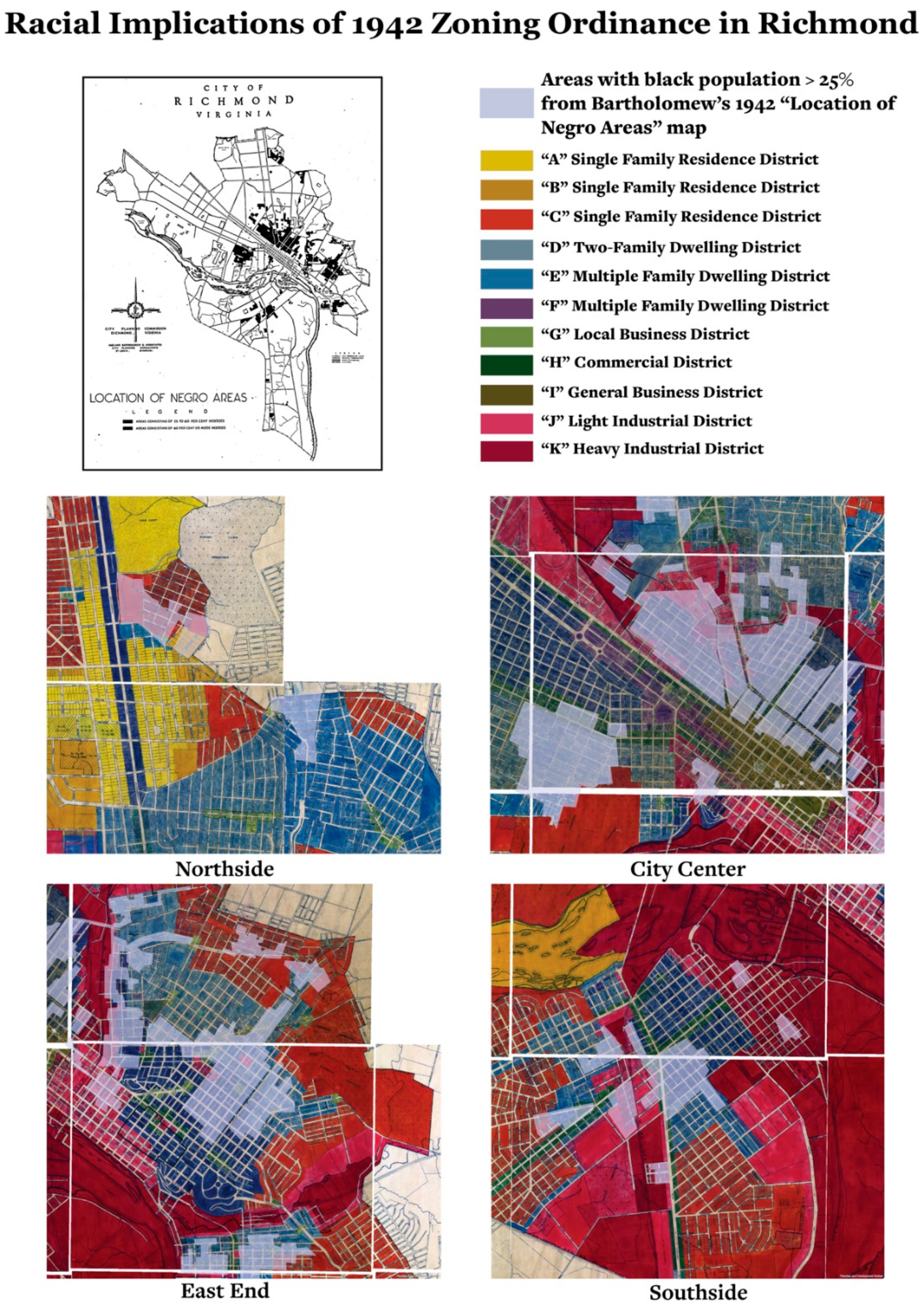
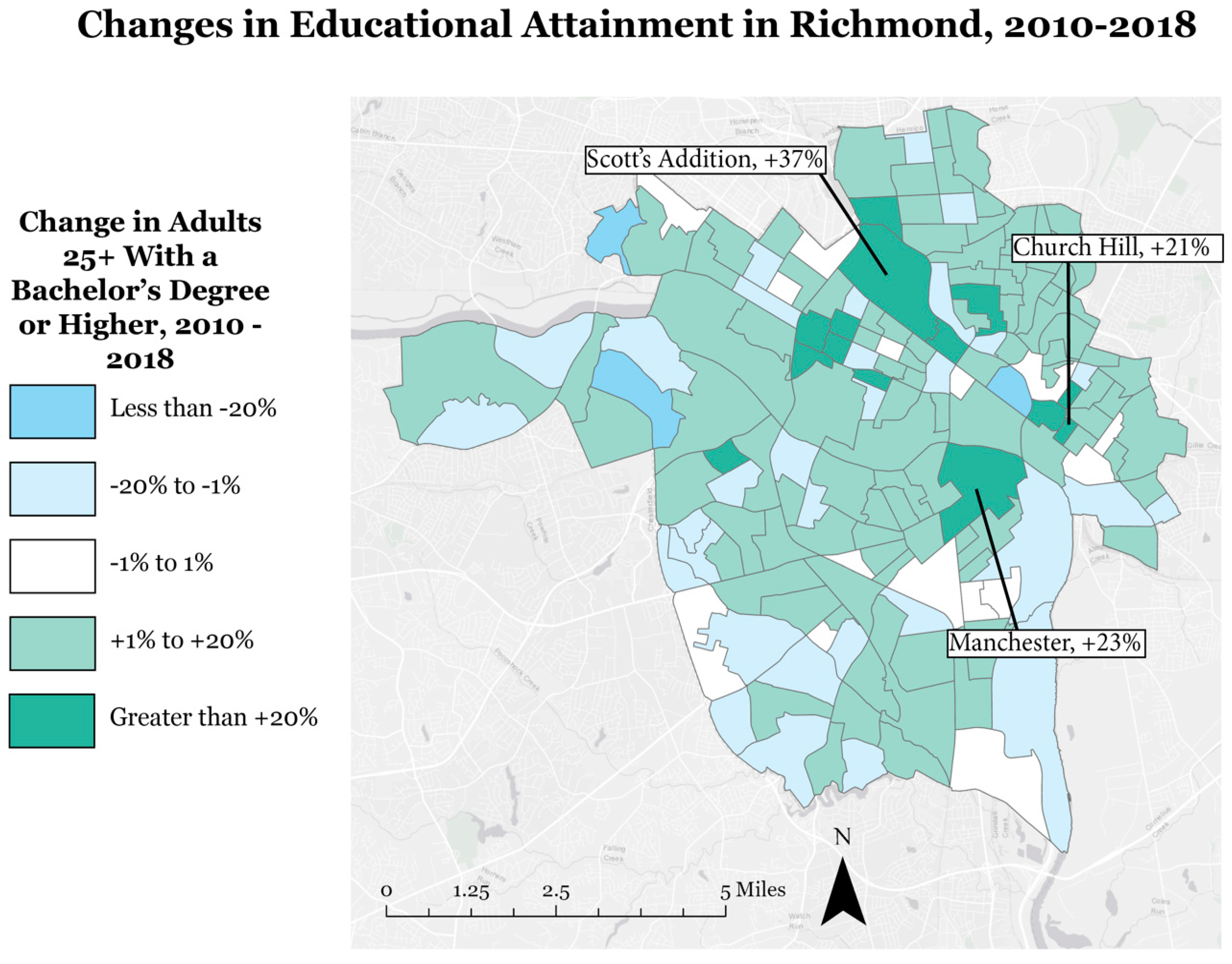
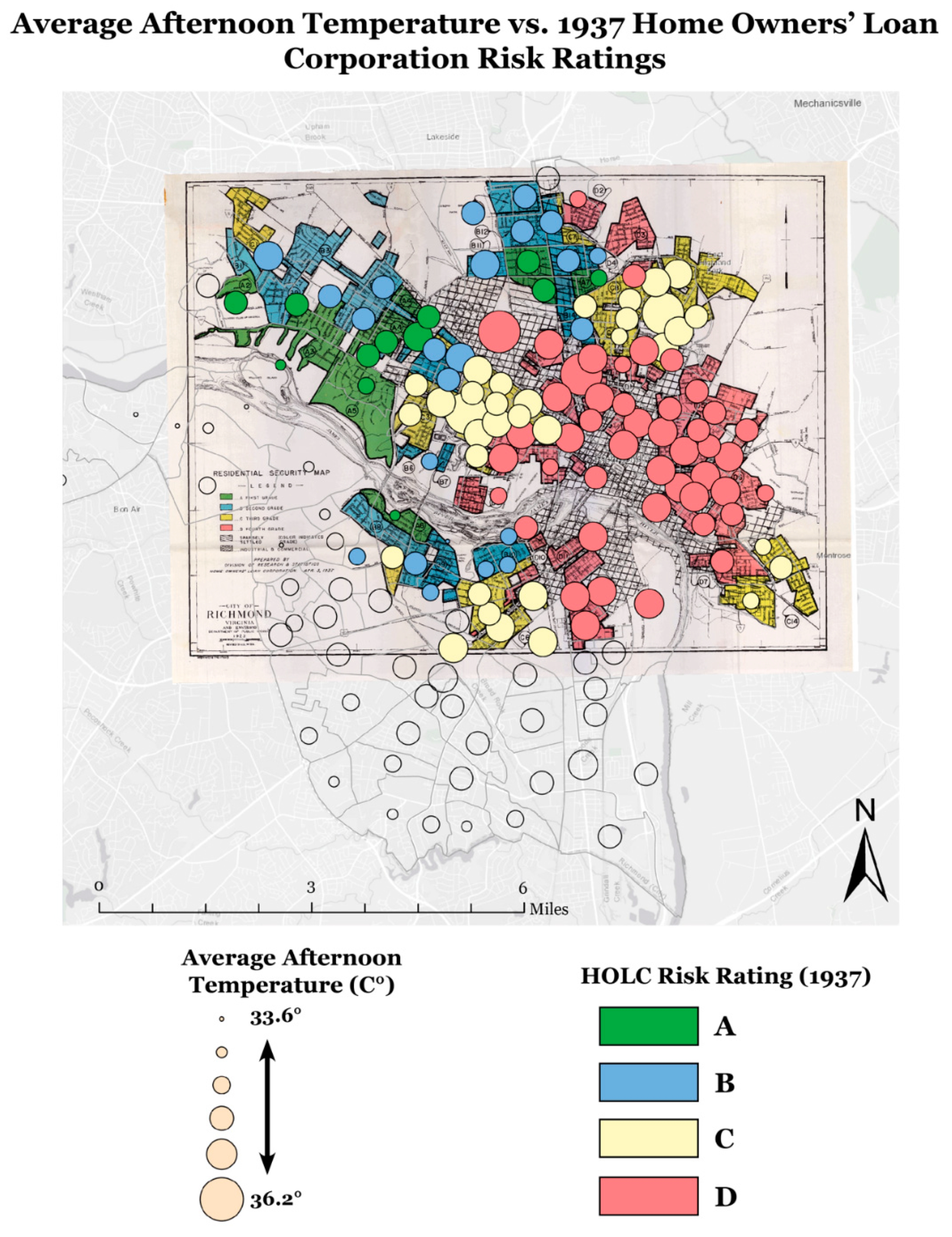
3. Results
4. Discussion
5. Conclusions
Author Contributions
Funding
Institutional Review Board Statement
Informed Consent Statement
Data Availability Statement
Acknowledgments
Conflicts of Interest
References
- IPCC. Climate Change 2014: Synthesis Report. Contribution of Working Groups I, II and III to the Fifth Assessment Report of the Intergovernmental Panel on Climate Change; Core Writing Team, Pachauri, R.K., Meyer, L.A., Eds.; IPCC: Geneva, Switzerland, 2014; p. 151. [Google Scholar]
- NASA. Facts: The Effects of Climate Change. Available online: https://climate.nasa.gov/effects/ (accessed on 25 November 2020).
- Wang, S.S.-Y.; Kim, H.; Coumou, D.; Yoon, J.-H.; Zhao, L.; Gillies, R.R. Consecutive Extreme Flooding and Heat Wave in Japan: Are They Becoming a Norm? Atmos. Sci. Lett. 2019, 20. [Google Scholar] [CrossRef]
- Borden, K.A.; Cutter, S.L. Spatial patterns of natural hazards mortality in the United States. Int. J. Health Geogr. 2008, 7. [Google Scholar] [CrossRef] [PubMed]
- Habeeb, D.; Vargo, J.; Stone, B., Jr. Rising Heat Wave Trends in Large US Cities. Nat. Hazards 2015, 76, 1651–1665. [Google Scholar] [CrossRef]
- Arnfield, A.J. two decades of urban climate research: A review of turbulence, exchanges of energy and water, and the urban heat island. Int. J. Climatol. 2003, 23, 1–26. [Google Scholar] [CrossRef]
- Kimuku, C.W.; Ngigi, M. Study of urban heat island trends to aid urban planning in Nakuru County-Kenya. J. Geogr. Inf. Syst. 2017, 9, 309–325. [Google Scholar] [CrossRef]
- Chakraborty, T.; Hsu, A.; Manya, D.; Sheriff, G. A Spatially Explicit Surface Urban Heat Island Database for the United States: Characterization, Uncertainties, and Possible Applications. ISPRS J. Photogramm. Remote Sens. 2020, 168, 74–88. [Google Scholar] [CrossRef]
- Livesley, S.J.; Mcpherson, E.G.; Calfapietra, C. The urban forest and ecosystem services: Impacts on urban water, heat, and pollution cycles at the tree, street, and city scale. J. Environ. Qual. 2016, 45, 119–124. [Google Scholar] [CrossRef]
- Solecki, W.D.; Rosenzweig, C.; Parshall, L.; Pope, G.; Clark, M.; Cox, J.; Wiencke, M. Mitigation of the heat island effect in urban New Jersey. Environ. Hazards 2005, 6, 39–49. [Google Scholar] [CrossRef]
- Farina, A. Exploring the Relationship between Land Surface Temperature and Vegetation Abundance for Urban Heat Island Mitigation in Seville, Spain. Master’s Thesis, Lund University, Lund, Sweden, 2012. [Google Scholar]
- Ziter, C.D.; Pederson, E.J.; Kucharik, C.J.; Turner, M.G. Scale-dependent interactions between tree canopy cover and impervious surfaces reduce daytime urban heat during summer. Proc. Natl. Acad. Sci. USA 2019, 116, 7575–7580. [Google Scholar] [CrossRef]
- Wilson, B. Urban heat management and the legacy of redlining. J. Am. Plan. Assoc. 2020, 86, 443–457. [Google Scholar] [CrossRef]
- Voelkel, J.; Hellman, D.; Sakuma, R.; Shandas, V. Assessing vulnerability to urban heat: A study of disproportionate heat exposure and access to refuge by socio-demographic status in Portland, Oregon. Int. J. Environ. Res. Public Health 2018, 15, 640. [Google Scholar] [CrossRef] [PubMed]
- Jones-Correa, M. The origins and diffusion of racial restrictive covenants. Political Sci. Q. 2000, 115, 541–568. [Google Scholar] [CrossRef]
- Hillier, A.E. Redlining and the home owners’ loan corporation. J. Urban Hist. 2003, 29, 394–420. [Google Scholar] [CrossRef]
- Mitchell, B.; Franco, J. HOLC “Redlining” Maps: The Persistent Structure of Segregation and Economic Inequality; National Community Reinvestment Coalition (NCRC): Washington, DC, USA, 2018; pp. 1–29. [Google Scholar]
- Manning Thomas, J.; Ritzdorf, M. (Eds.) The Racial Origins of Zoning in American Cities. In Urban Planning and the African Community: In the Shadows; Sage Publications: Thousand Oaks, CA, USA, 1997. [Google Scholar]
- United States Commission on Civil Rights (USCCR). Understanding Fair Housing; Government Printing Office: Washington, DC, USA, 1973; p. 5.
- Rothstein, R. The Color of Law: A Forgotten History of How Our Government Segregated America; Liveright Publishing Corporation A Division of W. W. Norton & Company: New York, NY, USA, 2017. [Google Scholar]
- Hoffman, J.S.; Shandas, V.; Pendleton, N. The Effects of Historical Housing Policies on Resident Exposure to Intra-Urban Heat: A Study of 108 US Urban Areas. Climate 2020, 8, 12. [Google Scholar] [CrossRef]
- U.S. Census Bureau QuickFacts: Richmond City, Virginia; United States. Available online: https://www.census.gov/quickfacts/richmondcityvirginia (accessed on 15 August 2020).
- Homer, C.; Dewitz, J.; Yang, L.; Jin, S.; Danielson, P.; Xian, G.; Coulston, J.; Herold, N.; Wickham, J.; Megown, K. Completion of the 2011 national land cover database for the conterminous United States–Representing a decade of land cover change information. Photogramm. Eng. Remote Sens. 2015, 81, 345–354. [Google Scholar]
- Richmond Planning and Development Review Department. “Richmond 300 Insights Report”. 2017. Available online: http://richmond300.com/sites/default/files/InsightsReport_Sept2018_180906.pdf (accessed on 2 September 2020).
- Richmond Times-Dispatch; NewsBank, Inc.: Richmond, VA, USA, 1942; p. 6.
- Summers, B.T. Capital Reinvestment: Riot, Renewal, and the Rise of a Black Ghetto. In Black in Place: The Spatial Aesthetics of Race in a Post-Chocolate City; The University of North Carolina Press: Chapel Hill, CA, USA, 2019; pp. 28–60. [Google Scholar]
- Shandas, V.; Voelkel, J.; Williams, J.; Hoffman, J. Integrating Satellite and Ground Measurements for Predicting Locations of Extreme Urban Heat. Climate 2019, 7, 5. [Google Scholar] [CrossRef]
- 2010 Census Blocks Map RVA. Available online: https://www2.census.gov/geo/maps/dc10map/tract/st51_va/c51760_richmond_city/DC10CT_C51760_001.pdf (accessed on 6 August 2020).
- ArcGIS Parks and Open Space. Available online: http://www.arcgis.com/home/webmap/viewer.html?webmap=879f1b39d1754e2f80d7b35a747622b6 (accessed on 6 August 2020).
- Nelson, R.K. Race and Redlining in Richmond. Redlining Richmond n.d. Available online: https://dsl.richmond.edu/holc/pages/intro (accessed on 1 October 2020).
- American Community Survey (ACS) 5-Year Estimates 2014–2018. Available online: http://data.census.gov/ (accessed on 28 July 2020).
- American Community Survey (ACS) 5-Year Estimates 2006–2010. Available online: http://data.census.gov/ (accessed on 28 July 2020).
- Nardone, A.; Chiang, J.; Corburn, J. Historic redlining and urban health today in U.S. Cities. Environ. Justice 2020, 13, 109–119. [Google Scholar] [CrossRef]
- Smith, M.L.; Hardeman, R.R. Association of summer heat waves and the probability of preterm birth in minnesota: An exploration of the intersection of race and education. Int. J. Environ. Res. Public Health 2020, 17, 6391. [Google Scholar] [CrossRef]
- Nardone, A.L.; Casey, J.A.; Rudolph, D.E.; Karasek, D.; Mujahid, M.; Morello-Frosch, R. Associations between historical redlining and birth outcomes from 2006 through 2015 in California. PLoS ONE 2020, 15. [Google Scholar] [CrossRef]
- Krieger, N.; Van Wye, G.; Huynh, M.; Waterman, P.D.; Maduro, G.; Li, W.H.; Gwynn, R.C.; Barbot, O.; Bassett, M.T. Structural Racism, Historical Redlining, and Risk of Preterm Birth in New York City, 2013–2017. Am. J. Public Health 2020, 110, 1046–1053. [Google Scholar] [CrossRef]
- Bekkar, B.; Pacheco, S.; Basu, R.; DeNicola, N. Association of air pollution and heat exposure with preterm birth, low birth weight, and stillbirth in the US: A Systematic Review. JAMA Netw. Open 2020, 3, e208243. [Google Scholar] [CrossRef] [PubMed]
- Domkea, G.M.; Oswaltb, S.N.; Waltersa, B.F.; Morinc, R.S. Tree planting has the potential to increase carbon sequestration capacity of forests in the United States. Proc. Natl. Acad. Sci. USA 2020, 117, 24649–24651. [Google Scholar] [CrossRef] [PubMed]
- Brancalion, P.H.S.; Holl, K.D. Guidance for successful tree planting initiatives. J. Appl. Ecol. 2020, 57, 2349–2361. [Google Scholar] [CrossRef]
- Nowak, D.J.; Appleton, N.; Ellis, A.; Greenfield, E. Residential building energy conservation and avoided power plant emissions by urban and community trees in the United States. Urban For. Urban Green. 2017, 21, 158–165. [Google Scholar] [CrossRef]
- Boycourt, L.A. Richmond Tree Initiative to Combat Heat, Pollution, Inequity. Available online: https://chesapeakebaymagazine.com/richmond-tree-initiative-to-combat-heat-pollution-inequity/ (accessed on 29 November 2020).
- Richmond Planning and Development Review Department. “Richmond 300: A Guide for Growth”. June 2020. Available online: http://www.richmond300.com/sites/default/files/R300_LowResDraft_200603.pdf (accessed on 2 September 2020).
- City of Richmond RVAgreen 2050. What is RVAgreen 2050? Available online: https://www.rvagreen2050.com/what-is-rvagreen-2050 (accessed on 2 September 2020).
- Engemann, K.; Bøcker, C.; Arge, L.; Tsirogiannis, C.; Mortensen, P.B.; Svennings, J. Residential green space in childhood is associated with lower risk of psychiatric disorders from adolescence into adulthood. Proc. Natl. Acad. Sci. USA 2019, 116, 5188–5193. [Google Scholar] [CrossRef]
- The History of Scott’s Addition. Available online: https://www.scottsaddition.com/history-of-scotts-addition/ (accessed on 25 November 2020).
- About Scott’s Addition. Available online: https://www.scottsaddition.com/about-scotts-addition/ (accessed on 25 November 2020).
- Scott’s Addition Demographics. Available online: https://www.point2homes.com/US/Neighborhood/VA/Scott-s-Addition-Demographics.html#:~:text=Scott’s%20Addition%20is%20an%20area,with%20a%20population%20of%206%2C505.&text=The%20median%20age%20of%20the,married%20and%204%2C133%20being%20single (accessed on 25 November 2020).


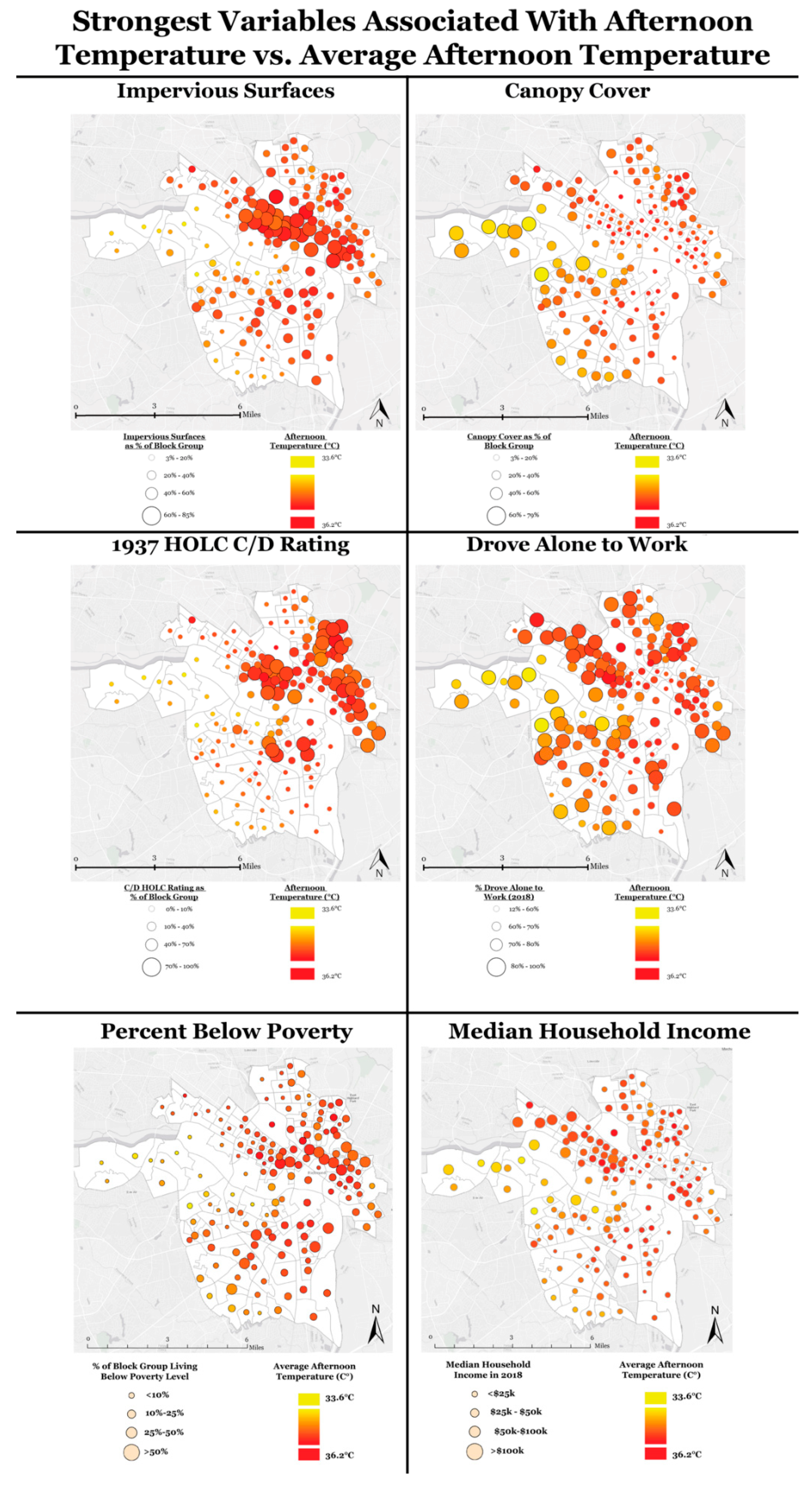
| Variable | Q1 Average | Q4 Average | Temperature Difference °C (Q4–Q1) | t-Test p-Value |
|---|---|---|---|---|
| Impervious surface (%) | 17.38 | 52.71 | 1.01 | 3.18 × 10⁻¹⁹ |
| Canopy cover (%) | 13.76 | 47.87 | −0.96 | 1.36 × 10⁻¹⁸ |
| Redlining C + D (%) | 0 | 83.79 | 0.53 | 3.15 × 10⁻⁶ |
| Drove alone to work (%) | 47.5 | 88.13 | −0.51 | 4.27 × 10⁻⁶ |
| Below poverty level (%) | 18.21 | 30.98 | 0.51 | 0.0015 |
| Median household income ($) | 22,615 | 98,945 | −0.41 | 0.0008 |
| Per capita income ($) | 11,293 | 57,490 | −0.37 | 0.002 |
| White population (%) | 7.6 | 89.31 | −0.31 | 0.007 |
| Detached housing (%) | 12.31 | 93.13 | −0.31 | 0.009 |
| Green space (%) | 0 | 17.81 | −0.3 | 0.0097 |
| Black population (%) | 6.09 | 86.9 | 0.27 | 0.0156 |
| Redlining A + B (%) | 0 | 55.53 | −0.26 | 0.011 |
| Non-Hispanic white population (%) | 2.43 | 88.46 | −0.26 | 0.0158 |
| Attached housing (%) | 0 | 20.07 | 0.25 | 0.024 |
| Bachelor’s degree or more (%) | 6.108 | 74.6 | −0.11 | 0.248 |
| Hispanic population (%) | 0.056 | 19.2 | 0.09 | 0.378 |
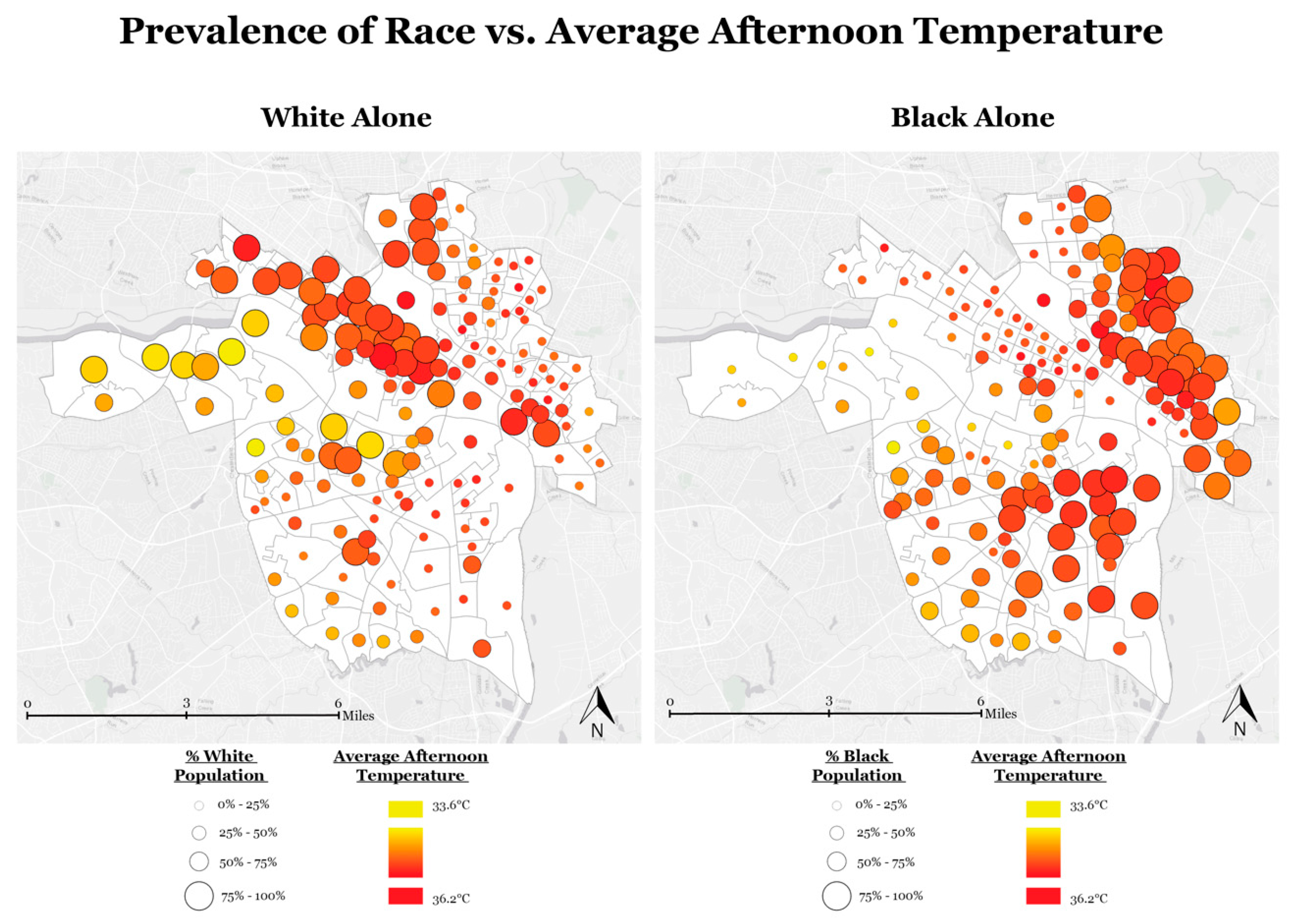
| Variable | Q1 Average | Q4 Average | Temperature Difference °C (Q4-Q1) | t-Test p-Value |
|---|---|---|---|---|
| Median household income ($) | 19,046 | 80,909 | −0.5 | 1.72 × 10⁻⁵ |
| Drove alone to work (%) | 46.12 | 88.77 | −0.46 | 0.0001 |
| Non-Hispanic white population (%) | 4.6 | 87.81 | −0.33 | 0.0038 |
| Bachelor’s degree or more (%) | 2.94 | 72.88 | −0.29 | 0.0106 |
| White population (%) | 3.28 | 90.24 | −0.28 | 0.0091 |
| Black population (%) | 5.44 | 93.64 | 0.26 | 0.0124 |
| Hispanic population (%) | 0 | 14.95 | 0.09 | 0.4284 |
| Variable | South (206 East) | South (206 West) | North (207) |
|---|---|---|---|
| Mean afternoon temperature (°C) | 35.69 | 35.7 | 35.96 |
| Below poverty level (%) | 8.3 | 15.67 | 39.27 |
| Per capita income ($) | 40,508 | 37,757 | 17,104 |
| Median household income ($) | 66,620 | 45,673 | 22,135 |
| White population (%) | 48.46 | 73.11 | 17.1 |
| Black population (%) | 34.46 | 19.34 | 75.52 |
| Redlining Category D (%) | 67.8 | 38.37 | 56.89 |
| Property value ($) | 232,000 | 229,950 | 129,888 |
Publisher’s Note: MDPI stays neutral with regard to jurisdictional claims in published maps and institutional affiliations. |
© 2021 by the authors. Licensee MDPI, Basel, Switzerland. This article is an open access article distributed under the terms and conditions of the Creative Commons Attribution (CC BY) license (http://creativecommons.org/licenses/by/4.0/).
Share and Cite
Saverino, K.C.; Routman, E.; Lookingbill, T.R.; Eanes, A.M.; Hoffman, J.S.; Bao, R. Thermal Inequity in Richmond, VA: The Effect of an Unjust Evolution of the Urban Landscape on Urban Heat Islands. Sustainability 2021, 13, 1511. https://doi.org/10.3390/su13031511
Saverino KC, Routman E, Lookingbill TR, Eanes AM, Hoffman JS, Bao R. Thermal Inequity in Richmond, VA: The Effect of an Unjust Evolution of the Urban Landscape on Urban Heat Islands. Sustainability. 2021; 13(3):1511. https://doi.org/10.3390/su13031511
Chicago/Turabian StyleSaverino, Kelly C., Emily Routman, Todd R. Lookingbill, Andre M. Eanes, Jeremy S. Hoffman, and Rong Bao. 2021. "Thermal Inequity in Richmond, VA: The Effect of an Unjust Evolution of the Urban Landscape on Urban Heat Islands" Sustainability 13, no. 3: 1511. https://doi.org/10.3390/su13031511
APA StyleSaverino, K. C., Routman, E., Lookingbill, T. R., Eanes, A. M., Hoffman, J. S., & Bao, R. (2021). Thermal Inequity in Richmond, VA: The Effect of an Unjust Evolution of the Urban Landscape on Urban Heat Islands. Sustainability, 13(3), 1511. https://doi.org/10.3390/su13031511