Article

A Pilot Project to Limit the Human Impacts on the Fragile Antarctic Biota: Mitigation of a Runway through Vegetation Transplantation

1
Department of Science and High Techonology, Insubria University, 22100 Como, Italy
2
Department Theoretical and Applied Sciences, Insubria University, 21100 Varese, Italy
*
Author to whom correspondence should be addressed.
Sustainability 2021, 13(2), 811; https://doi.org/10.3390/su13020811
Submission received: 14 December 2020 / Revised: 7 January 2021 / Accepted: 11 January 2021 / Published: 15 January 2021
(This article belongs to the Section Sustainability, Biodiversity and Conservation)

Abstract

:
Background: Antarctica is among the world’s last great wildernesses, but the anthropogenic activities and associated infrastructures threaten its fragile biota. We quantify the impact of the construction of a 2200 m long gravel runway airstrip for airfreight operations of the Italian research station on vegetation ecosystems at Boulder Clay (continental Antarctica). We propose a pilot project to mitigate this impact through the transplantation of vegetation from the runway to safe sites. Methods: A vegetation field survey was performed through phytosociological relevés and vegetation mapping and data were analyzed through multivariate analysis. Results: We quantify the destructive impact of the runway construction on the flora and vegetation of Boulder Clay. Based on vegetation characteristics, 28 priority areas were transplanted from the runway to safe sites, with 89% of survival. Conclusions: To our knowledge, this is the first time that vegetation transplantation was performed in Antarctica to mitigate the consequences of human actions, as formerly it was used only for scientific experiments. This pilot project provides a tool to support management decisions, involving the quantitative evaluation of the infrastructure impacts and showing the suitability of practical mitigation actions. This pilot project proposes a practical tool exportable to all Antarctica and beyond and suggests to link the permissions’ release for the new infrastructures in Antarctica to the realization of specific conservation and mitigation actions.

1. Introduction

Antarctica is a unique continent for its wilderness and relatively pristine nature (due to very limited human footprint), with ecosystems characterized by substantial and high biodiversity, although highly sensitive and fragile due to their adaptation to extremely harsh climatic conditions [1,2,3,4,5]. For these values, this continent has been devoted to peace and science according to the terms of the Antarctic Treaty since 1961 [6] (http://www.ats.aq). Despite the Antarctic Treaty would commit to the comprehensive protection of the environment, the human impacts in Antarctica are disproportionately concentrated in some of the most sensitive environments, with direct and indirect disturbance associated to human infrastructures and activities accounting for almost half of the coastal ice free areas, and consequential relevant implications for conservation management [7].
Within continental Antarctica, Victoria Land (Ross sector) is characterized by the highest levels of vegetation biodiversity (in terms of species richness), with the documented occurrence of c. 63 species of lichens [8,9,10] (although some papers report up to 92 lichen species [11]) and of 14 species of bryophytes [12,13].
Globally, the term “footprint” has been used to describe the spatial nature of environmental impacts and, in the last 25 years, this term has become common in environmental research in Antarctica, referring to the state of the environment around local human activities and providing a baseline for their monitoring [14]. Victoria Land (Ross sector) hosts the research stations of six different nations (Italy, Germany, China and Korea at 74° S, while the USA and New Zealand at 77° S), with the main airport operating the whole year being located close to McMurdo (77° S) and a temporary airport in Terra Nova Bay with landing on the sea-ice only during late spring. However, the operativity of Terra Nova Bay in the last years became limited due to an advance of sea ice melting earlier in the season. For this reason, at Boulder Clay (Victoria Land, continental Antarctica), since the Antarctic summer 2015/2016 the construction of a gravel runway airstrip was planned to start for the logistical airfreight operations pertinent to the functioning of the Italian research station Mario Zucchelli (Figure 1). The construction of the gravel airstrip is expected to be completed in the Antarctic summer 2020/21.
Before the runway construction Boulder Clay was a pristine area, characterized by the occurrence of the Antarctic non-vascular tundra cryptogamic vegetation with the occurrence of several species of mosses and lichens [9,15]. Boulder Clay hosts 2 of the 19 permanent plots of the long-term monitoring network to assess the impact of future climate and environmental changes on terrestrial ecosystems (in particular vegetation, permafrost and soils) established in Victoria Land in 2002 [15]. In 1999, a 100 × 100 m2 CALM grid was established at Boulder Clay for the long-term monitoring of permafrost, active layer (in the frame of the international panel CALM, Circumarctic Active Layer Monitoring) and of the associated vegetation, and has shown that a rapid environmental and ecological change is occurring in Antarctica likely in response to climate change [16].
According to the Annex I of the Protocol on Environmental Protection to the Antarctic Treaty [17] and the Guidelines for Environmental Impact Assessment in Antarctica (Resolution 4) [18], it is mandatory to perform the assessment of the environmental impact of the runway and associated infrastructures, as well as actions to mitigate its impact and reduce the assessed risks. The environmental assessment of the runway also included the analysis of the impacts on vegetation and the proposal of a mitigation plan during the runway construction to preserve from the total destruction of the native vegetation [19]. Indeed, in this pristine area, the runway construction (2200 m long and 60 m wide—including 45 m of runway and 7.5 m of shoulder area along each side) will imply a direct impact on ecosystems, with the total destruction of the flora and vegetation of the runway path and surrounding areas, as well as potential impacts concerning air and soil pollution, noise, landscape degradation.
Therefore, a protocol was developed for the assessment of the environmental impact of this infrastructure and a pilot project has been elaborated to test the proposed mitigation actions. To document and quantify the impact of the runway on the native vegetation, a detailed vegetation survey was performed out on the runway during the 2015/2016 season prior to the start of the construction operations. The availability of detailed data on the floristic composition of vegetation, the community types, their patterns of spatial distribution, and their ecology is mandatory for a proper evaluation of the consequences of the development of this infrastructure on the terrestrial ecosystems, as well as to elaborate a pilot project for the mitigation plan. In many cases, a suitable option to mitigate environmental degradation and achieve the restoration of damaged, degraded or destroyed ecosystems, is establishing or re-introducing flora and fauna [20,21,22]. In particular, especially in mountain areas of Europe, the transplanting of individuals of plant species or whole vegetation turfs has been applied to conserve communities, re-introduce species and for restoration in general [23,24,25,26].
To our knowledge, the transplantation of vegetation turves was never performed in Antarctica to mitigate the consequences of human actions, either aiming to ecosystem restoration, or to promote biodiversity conservation, but only for scientific experiments [27,28]. Here for the first time in Antarctica, we tested the vegetation transplantation to mitigate the impact of the runway construction, reducing its disruptive consequences and achieving the biological conservation of part of the native Antarctic biota. Through the pilot project described in this case study, we propose a protocol for: (a) the quantification of the consequences of the human actions on the native biota (vegetation) and, based on the achieved quantitative scientific data, (b) the planning and realization of mitigation actions to reduce this impact through transplanting of the threatened biota in safe sites.
Given the increasing impact of human activities in Antarctica, already involving half of the coastal ice-free areas of this continent [7], it is urgent to prevent further environmental damages. This approach could be exportable and applicable to the whole Antarctic context for the correct management and active conservation of the native Antarctic ecosystems, and could be applicable to other pristine native ecosystems threatened by the anthropogenic impact. We suggest that the realization of active conservation and mitigation actions (such as vegetation transplantation in safe sites) could be a mandatory condition to release the permits for the infrastructures subject to environmental impact assessment in Antarctica.

2. Materials and Methods
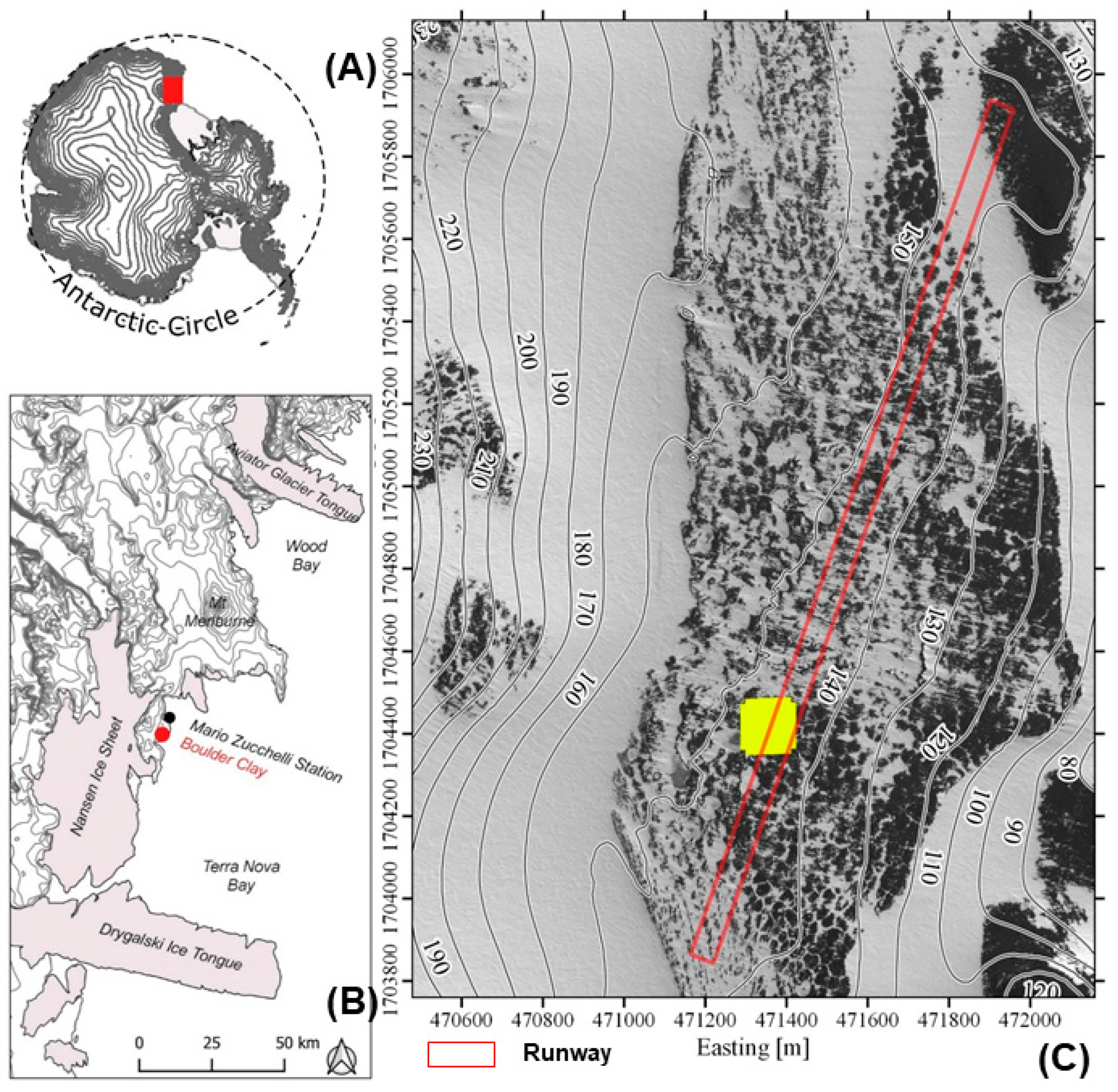
2.1. Study Area

Boulder Clay (74°44′45″ S, 164°01′17″ E, 205 m a.s.l.) is located in continental Antarctica, in Victoria Land (Ross sector) and specifically in the Northern Foothills, an ice free area about 6 km south of the Italian Mario Zucchelli Station, on a very gentle slope, with southeastern exposure (Figure 1A,B). Lithologically, the area is characterized by a granitic bedrock covered by morainic deposits of a Late Glacial ablation till overlying a body of dead glacier [15,29]. The site is characterized by the occurrence of perennially ice-covered ponds with icing blisters and frost mounds, as well as of periglacial features including frost fissure polygons and debris islands [29,30,31]. The till matrix is generally silty sand, with small patches of clayey silt [16]. Soils are Glacic Haplorthels and the chemical and physical parameters of the soils do not show peculiar characteristics at this site, except for the relatively high values of Al and Fe [32].
For what concerns vegetation, the Antarctic continent has traditionally been divided into three main biogeographical regions: maritime Antarctica (including the Antarctic Peninsula and the Scotia Arc island archipelagos), continental Antarctica, and sub-Antarctic Islands [12]. In this frame Victoria Land was included in the biogeographical region of continental Antarctica and the coastal areas (as Boulder Clay) were attributed to the coastal region [12]. A comprehensive analysis of the published biogeographical studies of the Antarctic allowed improving the biogeographic classification of Antarctica, identifying 16 distinct Antarctic Conservation Biogeographic Regions [3,5], although the most recent publication on this topic provided a different classification [33].
Traditionally, plant communities in Antarctica have been classified using the physiognomic-dominance criteria with the identification of two main vegetation formations: the Antarctic herb tundra formation (maritime Antarctic only) and the Antarctic non-vascular cryptogam tundra formation (composed entirely of microfungi, cyanobacteria, algae, lichens, bryophytes and occurring in continental Antarctica). For continental Antarctic vegetation there have been only a few studies applying phytosociological criteria for vegetation classification due to the taxonomic difficulties. For this reason, a reliable phytosociological classification of the Antarctic vegetation has been difficult to develop and, for Victoria Land, a vegetation classification has been proposed by Cannone and Seppelt [9] based on the floristic composition of vegetation communities and obtained applying the phytosociological method of Braun-Blanquet [34] (as this method has been demonstrated to be suitable for the Antarctic vegetation [35]). This classification aimed to provide a useful and easily applicable tool for standardized field measurement and subsequent data analysis and comparison, and for this reason it adopted a simplified nomenclature easily usable in the field, avoiding the use of complex syntaxa names.
The vegetation of Boulder Clay is an Antarctic non-vascular cryptogam tundra formation, exclusively of bryophytes and lichens [9,13,15,16,32]. The bryophyte communities are dominated by Syntrichia sarconeurum, Bryum argenteum, Schistidium antarctici and Syntrichia princeps with terricolous and epiphytic lichens such as Lecidella siplei, Caloplaca approximata and Candelariella flava and, in some cases, with Cyanobacteria [9,13,15,16]. The epilithic communities are very common and are characterized by macrolichens (Umbilicaria decussata, Usnea sphacelata, and Pseudephebe minuscula) as well as by crustose epilithic lichens (mainly Buellia frigida) [9,13,15,16]. Among bryophytes, one of the most frequent species is the moss B. argenteum, the genetic signature of which was recently analyzed in Antarctica [36]. Notably, at Boulder Clay, B. argenteum occurs with two main haplotypes (Hap 1, Hap 10), with Hap 10 being recognized to be an ancestral haplotype related to the earliest intra-Antarctic dispersal and diversification events identified for this species in Antarctica and likely occurred during a warming period at mid-Pliocene (around 3.5 Ma) [36]. Therefore, Boulder Clay represents an important location from the phylogeographic and phylogenetic research in Antarctica.
The Boulder Clay site represents the longest near continuous data series of permafrost and active layer temperature in Antarctica [37,38]. In 1999, a 100 × 100 m2 circumpolar active layer monitoring (CALM) grid [39] was established at this site (Figure 1C), one of the longest-term monitoring areas in continental Antarctica for the assessment of climate change impacts on ecosystems and on their associated physical environment (in particular cryosphere). In particular, the vegetation of the CALM grid is characterized by the occurrence of communities dominated by mosses (Schistidium antarctici, Bryum argenteum, Syntrichia princeps and Ceratodon purpureus) with epiphytic lichens and cyanobacteria colonizing the sediments with finer grain size, coupled with communities dominated by epilithic lichens, mainly occurring on pebbles and blocks [16]. In the period 2002–2013, within the CALM grid the vegetation exhibited a decrease of total and moss cover and a slight increase of lichens, concomitant to the active layer thickening and the increase of incoming solar radiation [16], showing the sensitivity of the Antarctic vegetation to even small changes in the climatic and environmental conditions. Unfortunately, the runway construction will imply the destruction of almost half of the CALM grid and the loss of data for future monitoring. In addition, Boulder Clay has been part of the long-term monitoring network installed since 2002/2003 at Victoria Land [15], with two permanent plots: one located on epilithic vegetation dominated by macrolichens (Umbilicaria decussata, Usnea sphacelata) colonizing big boulders and pebbles, and the other including scattered moss vegetation (Bryum argenteum, Schistidium antarctici) with epiphytic lichens, thus representing the two more frequent vegetations.
In the Boulder Clay area, the following vegetation groups of communities (reported as “orders” by Cannone and Seppelt [9]) (and formations indicated in brackets) were recorded to occur [9]:
-
Buellia frigida dominating (macrolichens and microlichens);
-
Lecidella siplei—Bryophytes (mixed lichen and bryophyte communities);
-
Epiphytic lichen encrusted Schistidium antarctici (lichen encrusted bryophytes);
-
Bryum argenteum and Cyanobacteria (pure bryophytes);
-
Cyanobacteria—Bryum-Ceratodon (pure bryophytes).

2.2. Biological Conservation Protocol—Field Investigations

The biological conservation protocol involves a first stage of field investigations for the quantitative assessment of the characteristics of the threatened ecosystems, followed by a second stage of planning the conservation actions and a third stage of practical application and monitoring.
In the field campaigns of 2015/2016 and 2016/2017, a detailed vegetation survey was carried out on the runway path and surrounding areas. The occurrence and spatial distribution of the different vegetation communities was described in detail: in particular, a phytosociological relevé was carried out for each vegetation community reported in the map [9,34,35]. For each relevé the total vegetation coverage (%), the floristic composition and the % coverage of each species, the GPS position, the size of the vegetated area and the physiognomic vegetation formation were recorded, following the same protocol adopted by Cannone and Seppelt [9] and Cannone et al. [40]. For bryophytes and lichen the field survey was carried out at the species level, while algae and cyanobacteria were recorded as generic categories (Algae; Cyanobacteria). Moreover, the fitness of the individuals was recorded for bryophytes (healthy vs. non healthy individuals). Species nomenclature followed Ochyra et al. [12] for bryophytes and Øvstedal and Smith [41] for lichens.
Vegetation patches were mapped as polygons when their size was ≥10 m2, while for smaller size (<10 m2) they were mapped as single points and all data were reported in a GIS system. Different vegetation maps were elaborated from the field data. In particular, three different vegetation coverage maps were elaborated concerning the occurrence and distribution of the main vegetation formations according to Cannone and Seppelt [9]: (a) coverage of the diffuse epilithic lichens colonization, (b) the coverage of different lichen formations (macrolichens and microlichens), (c) the coverage of the bryophyte dominated formations (both in pure stands as well as lichen-encrusted bryophytes).
For the elaboration of the vegetation map, the data of the vegetation relevés were analyzed to identify the vegetation communities according to the criteria identified by Cannone and Seppelt [9] and Cannone et al. [40]. Multivariate statistics (ordination by Principal Components Analysis—PCA) was performed to identify clusters corresponding to the main vegetation communities [9,40,42,43,44]. Specifically, PCA was carried out using a log transformation of the original data, applying scaling through centered standardization by samples, and the centered standardization by species, using the software CANOCO for Windows [45]. The results of the PCA allowed the elaboration of the vegetation map.

2.3. Pilot Project for Mitigation Actions—Conservation Planning, Transplant and Monitoring

According to the results of the vegetation survey and of the multivariate analysis, during the campaign 2016/2017 the priority areas were identified to plan the conservation actions for the mitigation aiming for biodiversity conservation and environmental protection.
The criteria to select the priority areas were the following:
  • Areas representative of the vegetation occurring within the runway path;
  • Areas with vegetation showing high coverage of the target/dominant species located in a limited area (in most cases ≤ 1 m2), with very healthy individuals;
  • Areas with vegetation associations with the characteristics described above and representing community types rare or with limited distribution/occurrence both within the runway path as well as in the surrounding areas;
  • Areas with vegetation characterized by the occurrence of rare species and/or with large and/or particularly healthy individuals.
The priority areas were selected among all vegetation associations occurring within the runway path, in order to preserve the natural biodiversity of the area erased by the runway construction.
The transplantation started during the season 2017/2018 with the removal and transplant of 17 vegetation patches (and underlying sediments/soils or substrata). For each vegetation patch re-localized outside the runway in a safe position, a permanent plot for the long-term monitoring of the mitigation action was installed to assess the survival of the transplanted species and/or eventual changes in the floristic composition, dominance and eventual ingression of other species. During the 2018/2019 season, the transplantation was performed on 11 vegetation patches (and underlying sediments/soils). To assess the success of the transplantation, a specific survey of the transplanted patches was performed in the austral summer 2019/2020. The monitoring will continue over the next few years with a re-survey of the transplanted areas to assess their survival and vitality.

3. Results

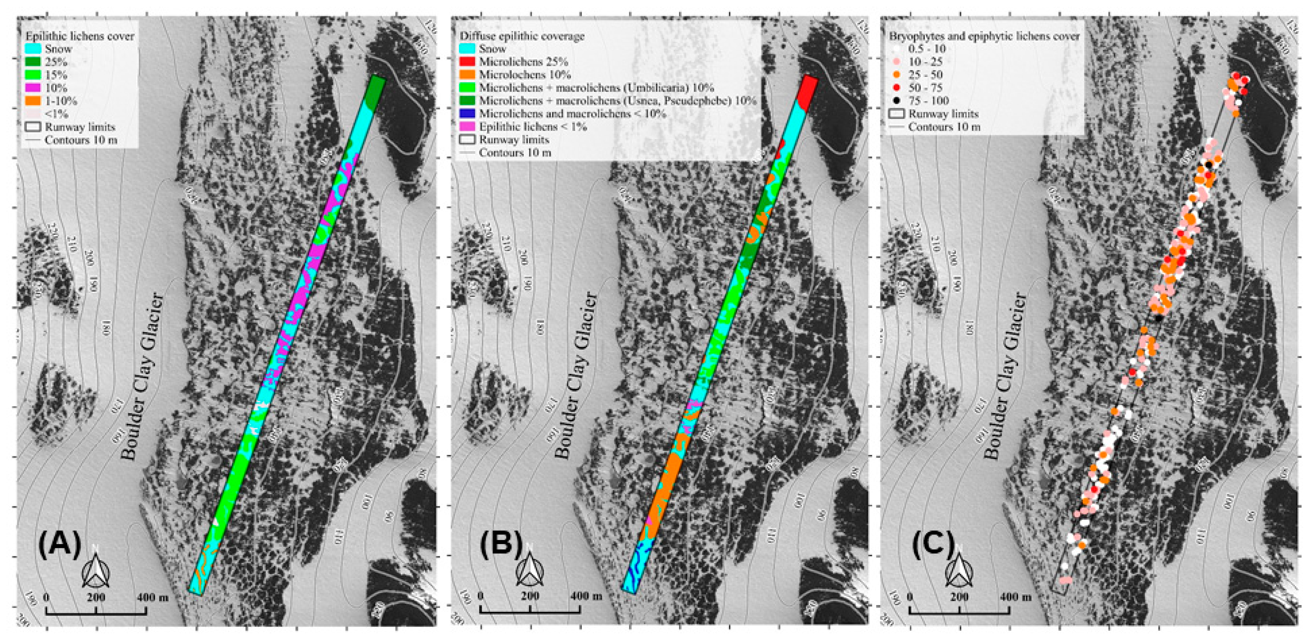
3.1. Flora and Vegetation of the Runway Pathway

The overall area of the runway covered by vegetation accounted for 5.8 ha (over a total runway area of 13.2 ha), involving different formations [9]. Epilithic lichens exhibited a diffuse colonization over the runway mainly on boulders and pebbles (with coverage ranging from <1% to 25%) (Figure 2A), with both macrolichens (foliose and fruticose lichens) and microlichens (crustose lichens) (Figure 2B). The coverage of epilithic lichens was generally low and discontinuous, with low discontinuous coverage (1.1% to 15%) being the prevailing condition, and only sporadically the occurrence of areas with relatively high epilithic lichen coverage (15.1% to 25%). The vegetation dominated by macrolichens and/or mixed macrolichens and bryophytes was mainly located in the central and southern side of the runway, closer to the area with the largest occurrence of frozen lakes and to the CALM grid area.
The runway was also characterized by a widespread occurrence of bryophytes, both as pure stands, as well as lichen-encrusted bryophytes, mainly growing on finer sediments, with coverage ranging from very scattered to continuous vegetation patches (Figure 2C). In most cases, bryophyte dominated formations mainly occurred as discontinuous vegetation (indeed, the most frequent % coverage classes were of 0.5% to 10% and of 10.1% to 25% showing the highest frequency, of 33.2% and 32.1%, respectively), evenly distributed on the runway path (Figure 2C). Bryophytes exhibited a higher coverage mainly within the first 1400 m of the runway (Figure 2C).
A total of 5.7 ha (43%) of the runway area were snow covered.
Concerning the phytosociological survey, a total of 371 vegetation relevés were performed on the runway path, recording the occurrence of two species of bryophytes, 18 species of lichens, and of Algae and Cyanobacteria (Table 1, Table S1 Supplementary Materials).
According to the PCA results, the following vegetation communities (and their formations indicated in brackets) were identified on the runway [9] (Figure 3):
1. Usnea antarctica–Umbilicaria decussata (macrolichens; PCA cluster I);
2. Buellia frigida dominating (macrolichens and microlichens; PCA cluster L);
3. Pseudephebe minuscula–Lecidella siplei—Bryophytes (mixed lichen and bryophyte communities; PCA cluster H);
4. Epiphytic lichens encrusting Bryum argentuem and Schistidium antarctici (lichen encrusted bryophytes);
6. Bryum argenteum and Cyanobacteria (pure bryophytes; PCA clusters A, E).
Moreover, a mosaic between groups 1 and 6 according to Cannone and Seppelt [9] (1/6; PCA clusters F, G), as well as between the groups 4 and 6 according to Cannone and Seppelt [9] (4/6; PCA clusters B, C, D) was identified (Figure 3). In addition, also pure stands of Cyanobacteria (PCA cluster M) and pure stands of Algae (PCA cluster N) were identified (Figure 3).
The vegetation map (Figure 4A) allowed identifying that 72% of the relevés were a mosaic of bryophytes and lichen-encrusted stands (4, 6, 4/6), with Schistidium antarctici occurring with a frequency more than double of Bryum argenteum, while 3.5% of the relevés were mixed lichen and bryophyte communities (3) and 6.4% were mosaic with macrolichens (1/6). Pure bryophytes (6), Cyanobacteria (7) and Algae (8) stands occurred only in 1.1%, 5.4% and 2.4% of the relevés, respectively. Macrolichens (1) dominated 7.3% of the relevés, while microlichen communities (2) co-dominated 1.9% of the relevés.

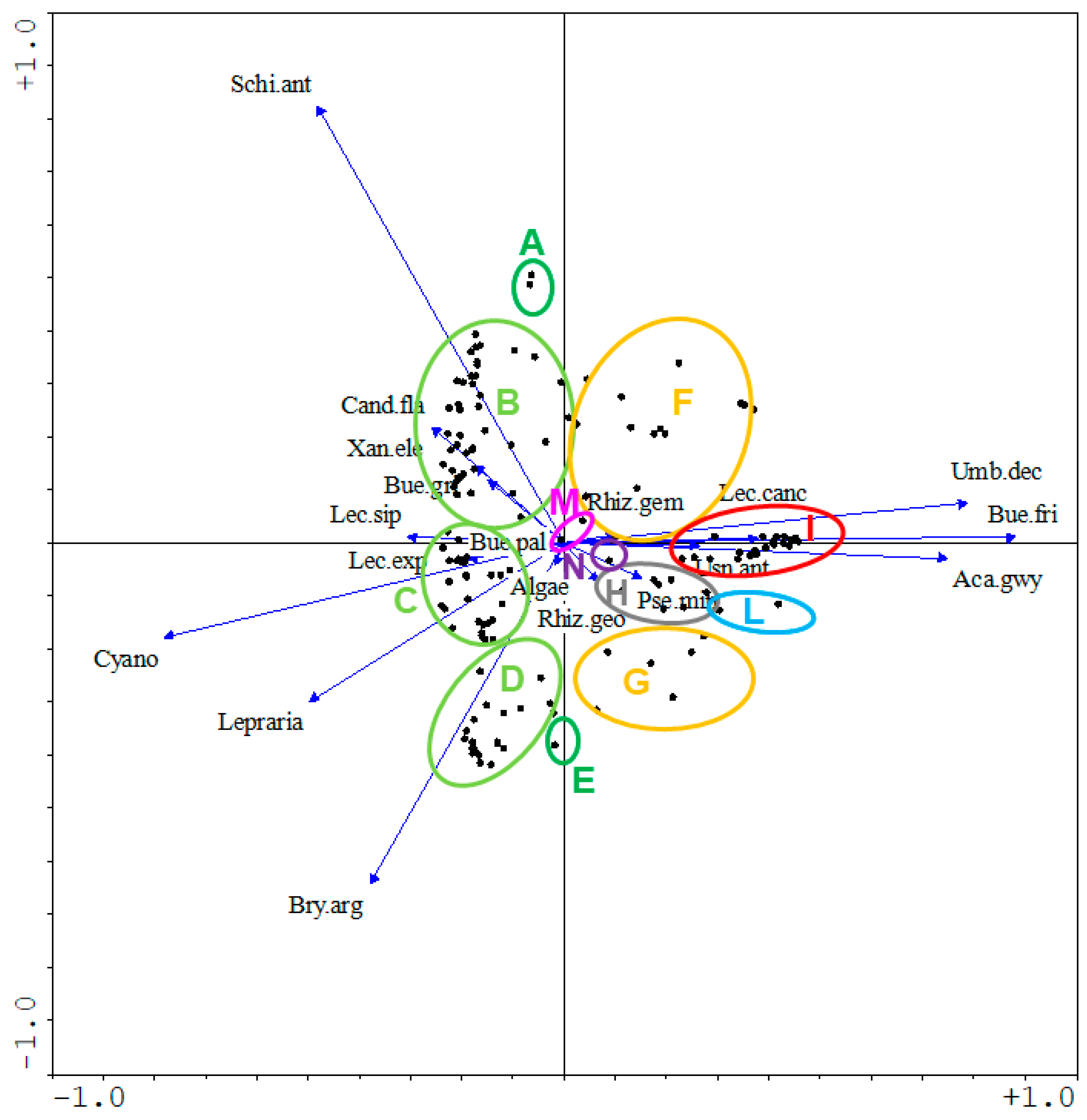
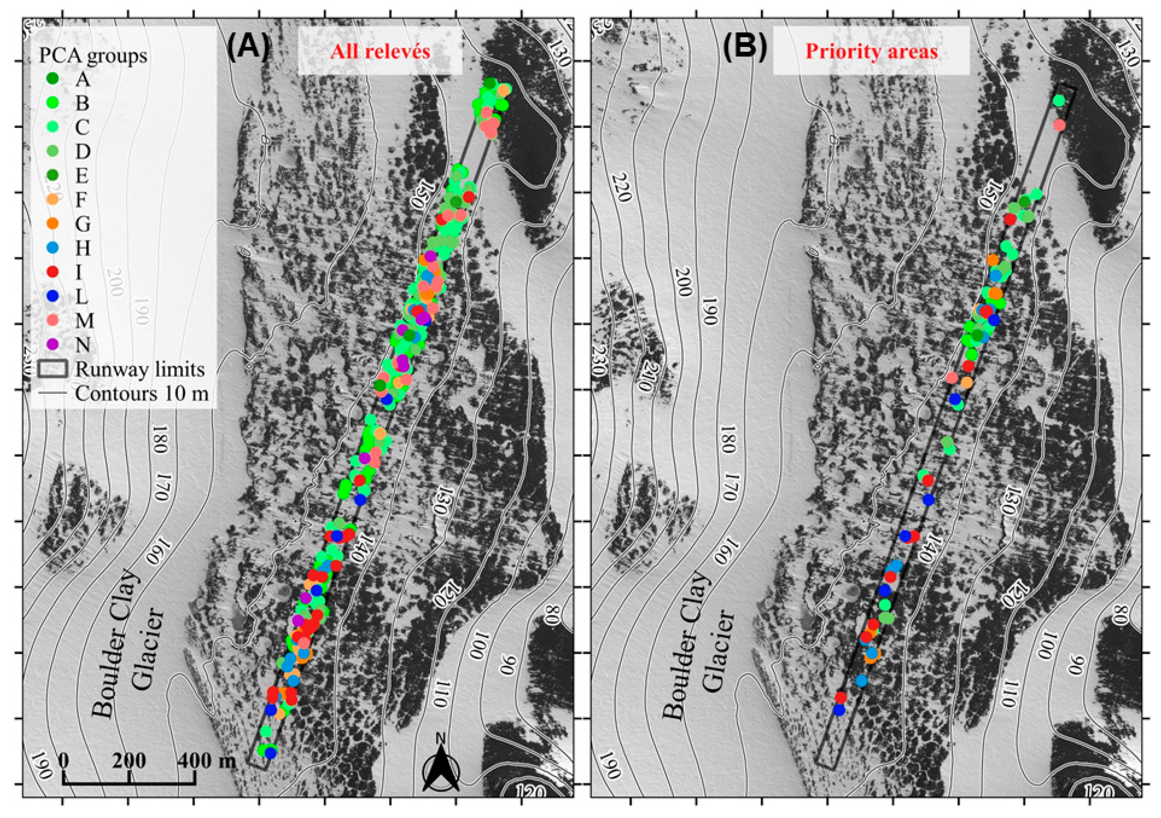
3.2. Active Conservation Planning and Realization through Transplantation

According to the results of the 371 vegetation relevés, a total of 80 candidate areas representative of the main community types observed within the runway path and characterized by the highest richness or plant fitness have been identified (Figure 4B; Table 2):
-
13 patches dominated by Usnea antarcticaUmbilicaria decussata (PCA cluster I);
-
6 patches dominated by Buellia frigida (PCA cluster L);
-
9 patches dominated by Pseudephebe minuscula-Lecidella siplei-Bryophytes (PCA cluster H);
-
2 patches dominated by Bryum argenteum and Cyanobacteria (PCA clusters A, E);
-
2 patches with Cyanobacteria pure stands (PCA cluster M);
-
9 patches dominated by the mosaic of Usnea-Umbilicaria and of Bryum-Cyanobacteria (PCA clusters F, G);
-
39 patches dominated by the mosaic of lichen-encrusted bryophytes and of Bryum-Cyanobacteria (PCA clusters B, C, D).
Among the 80 candidate areas, for this pilot experiment we selected 28 high priority areas for their transplantation in safe areas neighboring the runway in order to mitigate the impacts of the runway construction on vegetation. Indeed, without the transplantion all the native vegetation occurring within the runway would be damned to total destruction. The size of priority areas was ≤1 m2 to facilitate their transport and follow transplantion in safe areas.
The 28 priority areas were removed and re-located outside the runway (Table 2) at a distance from the west edge of the runway ranging between 52 and 163 m, respectively (average distance ± SD: 88 ± 28 m) (Figure 5). All transplantations were located westward from the runway taking account of the main wind direction (from west to east) in order to prevent accumulation of pollutants when the airstrip will be in operation.
The most transplanted community was the mosaic of lichen-encrusted bryophytes and Bryum-Cyanobacteria (53.6%; PCA clusters B, C, D), followed by the Usnea antarctica–Umbilicaria decussata (PCA cluster I), which was the second most transplanted (21.4%). The transplantation of communities characterized by the Buellia frigida dominance (PCA cluster L) accounted for 10.7% of the cases, while the mosaic of Usnea–Umbilicaria and Bryum–Cyanobateria (PCA clusters F, G) and patches of Pseudephebe minuscula–Lecidella siplei–Bryophytes (PCA cluster H) represented 7.2% and 7.1% of the re-located areas, respectively.
Keeping the pre-transplantation habitus as reference, the visual comparison of the vegetation (both on the field and through digital images) before and after the transplantations indicated a positive survival value of 89.3% of the re-localized patches (Table 2).

4. Discussion

4.1. Impact of the Runway on the Flora and Vegetation of Boulder Clay

The native vegetation occurring on the runway was characterized by a discontinuous coverage and occupied a surface of 5.8 ha (over a total runway area of 13.2 ha) destined to total vegetation destruction. The data of the vegetation survey allowed the assessment that the native vegetation of the runway was a mosaic of different vegetation formations, involving the occurrence of epilithic macro- and microlichens, and the widespread occurrence of bryophytes (both as pure stands as well as lichen-encrusted bryophytes). All the observed vegetation formations were a typical expression of the vegetation of Victoria Land [9]. In addition, the multivariate analysis (Figure 4) allowed the identification of several vegetation communities characterized by different ecological requirements, providing indirect information on the edaphic conditions of the runway path. Among the communities dominated by bryophytes, Bryum argenteum indicates the occurrence of mesic environments, while sites with lower water availability (e.g., due to less snow cover accumulation) were characterized by the occurrence of the xeric moss Schistidium antarctici. The occurrence of lichen encrusted bryophytes indicated lower water availability with respect to pure stands of bryophytes. These data are in agreement with the observation that in the last decade the vegetation of Boulder Clay exhibited a shift towards more xeric conditions due to increasing solar radiation and thickening of the active layer thickness (which were likely inducing changes in soil water drainage) [16].
Among the lichen dominated communities, the occurrence of Pseudephebe minuscula is often associated with late melting snow. Indeed, in many cases (also within the runway path) P. minuscula is associated with bryophytes and occurs in sheltered plates where snow accumulates more and tends to melt later, providing a longer and/or larger water supply. Similar ecology, although less mesic, characterizes Usnea antarctica, a species typical of Northern Victoria Land.
The communities characterized by the dominance and/or abundance of Umbilicaria decussata, an epilithic species with wide ecological amplitude concerning water availability, occur in xeric as well as in mesic habitats, both in pure stands (or associated with other epilithic lichen species) and associated with xeric bryophytes (such as Schistidium antarctici, as observed on the runway path).
Pure stands of Algae indicate the occurrence of higher water availability and nutrient enrichment, while Cyanobacteria tend to occur in pioneer conditions and/or where there is soil disturbance (e.g., periglacial features such as debris island).
The occurrence of these communities indicating different edaphic conditions concerning snow cover and water availability show that the runway path and surrounding areas provided several ecological niches allowing the development of well differentiated and rich vegetation communities. Moreover, the flora and vegetation recorded on the runway was representative of the floristic and vegetation patterns observed at Victoria Land [9,46,47,48,49], indicating that the impact of the runway destruction of the diversity of Boulder Clay has been relevant. Indeed, Boulder Clay is among the largest ice-free areas occurring in northern Victoria Land as testified also by the occurrence of an ancestral haplotype of the moss Bryum argenteum, related to the earliest intra-Antarctic dispersal and diversification events identified for this species in Antarctica and likely occurred during a warming period at mid-Pliocene (around 3.5 Ma) [36].

4.2. Pilot Project for the Active Biological Conservation through Vegetation Transplantation

Transplantation finalized to ecosystem restoration and/or conservation was mainly performed in the European mountains and mainly for vascular plants, although with limited success due to the tolerance of different plant communities and species to transplanting and also to the need to select an optimal turf size [26].
Concerning bryophytes, transplantations were mainly performed for the biomonitoring of environmental pollution [50,51,52], or for reciprocal transplantation experiments to assess the extent of local adaptation among populations by comparing the performance of local vs. foreign genotypes in each genotype’s local environment [53,54,55].
To our knowledge, this is the first pilot experiment performing the transplantation of bryophytes and lichen vegetation performed in Antarctica finalized to test its potential for the mitigation of the destructive impacts of a human infrastructure such as the runway construction on the pristine vegetation of Boulder Clay. Our data show that the transplantation of the 28 priority areas was successful with the survival of 89% of the transplanted patches (Table 2) and that this pilot procedure could be exportable to similar cases of infrastructure construction and/or disruptive human impacts in the fragile terrestrial polar ecosystems (including the Arctic and not only Antarctica).

5. Conclusions

This case study shows the suitability of this proposed protocol for the impact assessment and of the consequent pilot project for the impact mitigation. Indeed, this procedure could be successfully adopted in Antarctica and in polar areas in the future to limit the consequences of human actions (e.g., infrastructure building) and for the restoration of damaged ecosystems and/or their active conservation, and could be applied to other situations where the impact of anthropogenic activities is exerting damage or threat to the native species. Further, this protocol could be planned as compensatory action for the mitigation for the construction of all new infrastructures in Antarctica, therefore preserving the native species, concerning flora and vegetation, the underlying soil (with the associated microbiota) and the eventual invertebrate fauna. Indeed, this conservation issue is becoming urgent especially in Antarctica, where the increasing human impact is threatening the fragile Antarctic ecosystems, making mandatory the availability of protocols suitable to support management decisions allowing the balance of sustainable scientific-use and environmental protection of the Antarctic environment. Given the increasing human impact in Antarctica, we suggest to link the permissions’ release for the new infrastructures in Antarctica to the realization of specific conservation and mitigation actions similar to those illustrated by this case study.
Future perspectives will concern the prosecution of the monitoring of the survival of the transplanted priority areas, as well as the monitoring of the impacts associated with the activity of the runway as the new airport will be operating.

Supplementary Materials

The following are available online at https://www.mdpi.com/2071-1050/13/2/811/s1, Table S1: field data of the phytosociological relevés.

Author Contributions

N.C. conceived the ideas and designed the methodology; F.M. and S.P. collected the data; N.C. analyzed the data, N.C. led the writing of the manuscript. All authors contributed critically to the drafts and gave final approval for publication. All authors have read and agreed to the published version of the manuscript.

Funding

This research received no external funding.

Institutional Review Board Statement

Not applicable.

Informed Consent Statement

Not applicable.

Data Availability Statement

Data is contained within the article and in Supplementary Materials.

Conflicts of Interest

The authors declare no conflict of interest.

References

  1. Green, T.G.A.; Sancho, L.G.; Pintado, A.; Schroeter, B. Functional and spatial pressures on terrestrial vegetation in Antarctica forced by global warming. Polar Biol. 2011, 34, 1643–1656. [Google Scholar] [CrossRef]
  2. Hughes, K.A.; Fretwell, P.; Rae, J.; Holmes, J.; Fleming, A.H. Untouched Antarctica: Mapping a finite and diminishing environmental re source. Antarct. Sci. 2011, 23, 537–548. [Google Scholar] [CrossRef] [Green Version]
  3. Terauds, A.; Chown, S.L.; Morgan, F.; Peat, H.J.; Watts, D.J.; Keys, H.; Convey, P.; Bergstrom, D.M. Conservation biogeography of the Antarctic. Divers. Distrib. 2012, 18, 726–741. [Google Scholar] [CrossRef] [Green Version]
  4. Chown, S.L.; Clarke, A.; Fraser, C.I.; Cary, S.C.; Moon, K.L.; McGeoch, M.A. The changing form of Antarctic biodiversity. Nature 2015, 522, 431–438. [Google Scholar] [CrossRef]
  5. Terauds, A.; Lee, J.R. Antarctic biogeography revisited: Updating the Antarctic Conservation Biogeographic Regions. Divers. Distrib. 2016, 22, 836–840. [Google Scholar] [CrossRef] [Green Version]
  6. ATCM. Protocol on Environmental Protection to the Antarctic Treaty; Antarctic Treaty Secretariat: Buenos Aires, Argentina, 1991. [Google Scholar]
  7. Brooks, S.T.; Jabour, J.; Hoff, J.V.D.; Bergstrom, D.M. Our footprint on Antarctica competes with nature for rare ice-free land. Nat. Sustain. 2019, 2, 185–190. [Google Scholar] [CrossRef] [Green Version]
  8. Castello, M.; Nimis, P.L. A key to the lichens of Terra Nova Bay (Victoria Land, Continental Antarctica). Ital. J. Zool. 2000, 67, 175–184. [Google Scholar] [CrossRef]
  9. Cannone, N.; Seppelt, R. A preliminary floristic classification of Northern and Southern Victoria Land vegetation (Continental Antarctica). Antarct. Sci. 2008, 20, 553–562. [Google Scholar] [CrossRef]
  10. Smykla, J.; Krzewicka, B.; Wilk, K.; Emslie, S.D.; Śliwa, L. Additions to the lichen flora of Victoria Land, Antarctica. Pol. Polar Res. 2011, 32, 123–138. [Google Scholar] [CrossRef]
  11. Castello, M. Lichens of the Terra Nova Bay area, northern Victoria Land. Studia Geobotanica 2003, 22, 3–59. [Google Scholar]
  12. Ochyra, R.; Smith, R.I.L.; Bednarek-Ochyra, H. The Illustrated Moss Flora of Antarctica; Cambridge University Press: Cambridge, UK, 2008; p. 685. [Google Scholar]
  13. Cannone, N.; Convey, P.; Guglielmin, M. Diversity trends of bryophyties in continental Antarctica. Polar Biol. 2013, 36, 259–271. [Google Scholar] [CrossRef]
  14. Brooks, S.T.; Jabour, J.; Bergstrom, D.M. What is ‘footprint’ in Antarctica: Proposing a set of definitions. Antarct. Sci. 2018, 30, 227–235. [Google Scholar] [CrossRef] [Green Version]
  15. Cannone, N. A network for monitoring terrestrial ecosystems along a latitudinal gradient in Continental Antarctica. Antarct. Sci. 2006, 18, 549–560. [Google Scholar] [CrossRef]
  16. Mauro, G.; Fratte, M.D.; Cannone, N. Permafrost warming and vegetation changes in continental Antarctica. Environ. Res. Lett. 2014, 9, 045001. [Google Scholar]
  17. ATCM. Protocol on Environmental Protection to the Antarctic Treaty; Antarctic Treaty Secretariat: Tromso, Norway, 1998. [Google Scholar]
  18. ATCM. ATCM XXVIII—CEP VIII. In Guidelines for Environmental Monitoring; Antarctic Treaty Secretariat: Stockholm, Sweden, 2005. [Google Scholar]
  19. ATCM. ATCM XXXIX—CEP XIX, Annex A. In Comprehensive Environmental Evaluation. Proposed Construction and Operation of a Gravel Runway in the Area of Mario Zucchelli Station, Terra Nova Bay, Victoria Land, Antarctica; Antarctic Treaty Secretariat: Santiago, Chile, 2016. [Google Scholar]
  20. SERI. The SER International Primer on Ecological Restoration; Society for Ecological Restoration International: Tucson, AZ, USA, 2004. [Google Scholar]
  21. Menz, M.H.; Dixon, K.W.; Hobbs, R.J. Hurdles and opportunities for landscape-scale restoration. Science 2013, 339, 526–527. [Google Scholar] [CrossRef]
  22. Perring, M.P.; Standish, R.J.; Price, J.N.; Craig, M.D.; Erickson, T.E.; Ruthrof, K.X.; Whiteley, A.S.; Valentine, L.E.; Hobbs, R.J. Advances in restoration ecology: Rising to the challenges of the coming decades. Ecosphere 2015, 6, 131. [Google Scholar] [CrossRef] [Green Version]
  23. Bruelheide, H.; Flintrop, T. Evaluating the transplantation of a meadow in the Harz Mountains, Germany. Biol. Conserv. 2000, 92, 109–120. [Google Scholar] [CrossRef]
  24. Kiehl, K.; Kirmer, A.; Donath, T.W.; Rasran, L.; Hölzel, N. Species introduction in restoration projects—Evaluation of different techniques for the establishment of semi-natural grasslands in Central and Northwestern Europe. Basic Appl. Ecol. 2010, 11, 285–299. [Google Scholar] [CrossRef]
  25. Mehlhoop, A.C.; Evju, M.; Hagen, D. Transplanting turfs to facilitate recovery in a low-alpine environment—What matters? Appl. Veg. Sci. 2018, 21, 615–625. [Google Scholar] [CrossRef]
  26. Aradottir, A.L. Turf transplants for restoration of alpine vegetation: Does size matter? J. Appl. Ecol. 2012, 49, 439–446. [Google Scholar] [CrossRef]
  27. Edwards, J.A.; Greene, D.M. The survival of Falkland Island transplants at South Georgia and Signy Island, South Orkney Islands. Br. Antarct. Surv. Bull. 1973, 33, 33–45. [Google Scholar]
  28. Edwards, J.A. An experimental introduction of vascular plants from South Georgia to the maritime Antarctic. Br. Antarct. Surv. Bull. 1980, 49, 73–80. [Google Scholar]
  29. Guglielmin, M.; Biasini, A.; Smiraglia, C. Buried ice landforms in the Northern Foothills (Northern Victoria Land, Antarctica). Some results from electrical soundings. Geographyska Annaler 1997, 79a, 17–24. [Google Scholar] [CrossRef]
  30. French, H.M.; Guglielmin, M. Observations on the ice-marginal, periglacial geomorphology of Terra Nova Bay, Northern Victoria Land, Antarctica. Permafr. Periglac. Process. 1999, 10, 331–347. [Google Scholar] [CrossRef]
  31. French, H.; Guglielmin, M. Frozen ground phenomena in the vicinity of Terra Nova Bay, Northern Victoria land, Antarctica: A preliminary report. Geographyska Annaler Phys. Geogr. 2000, 82, 513–526. [Google Scholar] [CrossRef]
  32. Cannone, N.; Wagner, D.; Hubberten, H.W.; Guglielmin, M. Biotic and abiotic factors influencing soil properties across a latitudinal gradient in Victoria Land, Antarctica. Geoderma 2008, 144, 50–65. [Google Scholar] [CrossRef] [Green Version]
  33. Rivas-Martínez, S.; Del Río, S.; Penas, Á.; Herrero, L.; Prieto, I.; Álvarez, M.; Díaz, T.E.; Molero, J.; Rivas-Sáenz, S.; Cantó, P.; et al. Biogeographical and bioclimatic outline of Antarctica. Plant Biosyst. 2021, 155, 5–15. [Google Scholar]
  34. Braun-Blanquet, J. Pflanzensoziologie; Springer: Vienna, Austria, 1964; p. 865. [Google Scholar]
  35. Cannone, N. Minimum area assessment and different sampling approaches for the study of vegetation communities in Antarctica. Antarct. Sci. 2004, 16, 157–164. [Google Scholar] [CrossRef]
  36. Zaccara, S.; Patiño, J.; Convey, P.; Vanetti, I.; Cannone, N. Multiple colonization and dispersal events hide the early origin and induce a lack of genetic structure of the moss Bryum argenteum in Antarctica. Ecol. Evol. 2020, 10, 1–17. [Google Scholar] [CrossRef]
  37. Guglielmin, M. Observations on permafrost ground thermal regimes from Antarctica and the Italian Alps, and their relevance to global climate change. Glob. Planet. Chang. 2004, 40, 159–167. [Google Scholar]
  38. Guglielmin, M. Ground surface temperature (GST), active layer, and permafrost monitoring in continental Antarctica. Permafr. Periglac. Process. 2006, 17, 133–143. [Google Scholar] [CrossRef]
  39. Nelson, F.E.; Shiklomanov, N.I.; Hinkel, K.M.; Brown, J. Decadal results from the Circumpolar Active Layer Monitoring (CALM) program. In Proceedings of the 9th International Conference on Permafrost, Fairbanks, AK, USA, 28 June–3 July 2008; Kane, D.L., Hinkel, K.M., Eds.; University of Alaska Press: Fairbanks, AK, USA, 2008; Volume 1, pp. 1273–1780. [Google Scholar]
  40. Cannone, N.; Convey, P.; Malfasi, M. Antarctic Specially Protected Areas (ASPA): A case study at Rothera Point providing tools and perspectives for the implementation of the ASPA network. Biodivers. Conserv. 2018, 27, 2641–2660. [Google Scholar] [CrossRef]
  41. Øvstedal, D.O.; Smith, R.I.L. Lichens of Antarctica and South Georgia. A Guide to Their Identification and Ecology; Cambridge University Press: Cambridge, UK, 2001. [Google Scholar]
  42. Seppelt, R.D.; Türk, R.; Green, A.T.G.; Moser, G.; Pannewitz, S.; Sancho, L.G.; Schroeter, B. Lichen and moss communities of Botany Bay, Granite Harbour, Ross Sea, Antarctica. Antarct. Sci. 2010, 22, 691–702. [Google Scholar] [CrossRef]
  43. Favero-Longo, S.E.; Cannone, N.; Worland, M.R.; Convey, P.; Piervittori, R.; Guglielmin, M. Changes in lichen diversity and community structure with fur seal population increase on Signy Island, South Orkney Islands. Antarct. Sci. 2010, 23, 65–77. [Google Scholar] [CrossRef] [Green Version]
  44. Favero-Longo, S.E.; Worland, M.R.; Convey, P.; Smith, R.I.L.; Piervittori, R.; Guglielmin, M.; Cannone, N. Primary succession of lichen and bryophyte communities following glacial recession on Signy Island, South Orkney Islands, Maritime Antarctic. Antarct. Sci. 2012, 24, 323–336. [Google Scholar] [CrossRef] [Green Version]
  45. Ter Braak, C.J.F.; Šmilauer, P. CANOCO Reference Manual and CanoDraw for Windows User’s Guide: Software for Canonical Community Ordination (ver. 4.5); Microcomputer Power Ed.: Ithaca, NY, USA, 2002. [Google Scholar]
  46. Kappen, L. Vegetation and ecology of icefree areas of northern Victoria Land, Antarctica. 1. The lichen vegetation of birthday ridge and an inland mountain. Polar Biol. 1985, 4, 213–225. [Google Scholar] [CrossRef]
  47. Seppelt, R.D.; Green, T.G.A.; Schroeter, B. Lichens and mosses from the Kar Plateau, southern Victoria Land, Antarctica. N. Z. J. Bot. 1995, 33, 203–220. [Google Scholar] [CrossRef] [Green Version]
  48. Seppelt, R.D.; Green, T.G.A.; Schroeter, B. Addictions and corrections to the lichen flora of the Kar Plateau, southern Victoria Land, Antarctica. N. Z. J. Bot. 1996, 34, 329–331. [Google Scholar] [CrossRef]
  49. Seppelt, R.D.; Green, T.G.A. A bryophyte flora for southern Victoria Land, Antarctica. N. Z. J. Bot. 1998, 36, 617–635. [Google Scholar] [CrossRef]
  50. Fernandez, J.A.; Carballeira, A. Differences in the responses of native and transplanted mosses to atmospheric pollution: A possible role of selenium. Environ. Pollut. 2000, 110, 73–78. [Google Scholar] [CrossRef]
  51. Fernandez, J.A.; Aboal, J.R.; Carballeira, A. Use of native and transplanted mosses as complementary techniques for biomonitoring mercury around an industrial facility. Sci. Total Environ. 2000, 256, 151–161. [Google Scholar] [CrossRef]
  52. Kosior, G.; Samecka-Cymerman, A.; Kolon, K.; Kempers, A. Bioindication capacity of metal pollution of native and transplanted Pleurozium schreberi under various levels of pollution. Chemosphere 2010, 81, 321–326. [Google Scholar] [CrossRef] [PubMed]
  53. Kawecki, T.J.; Ebert, D. Conceptual issues in local adaptation. Ecol. Lett. 2004, 7, 1225–1241. [Google Scholar] [CrossRef] [Green Version]
  54. Hereford, J. A quantitative survey of local adaptation and fitness trade-offs. Am. Nat. 2009, 173, 579–588. [Google Scholar] [CrossRef] [Green Version]
  55. Merinero, S.; Dahlberg, J.; Ehrl, J.; Hylander, K. Intraspecific variation influences performance of moss transplants along microclimate gradients. Ecology 2020, 2020, e02999. [Google Scholar] [CrossRef] [Green Version]
Figure 1. Location of the study area with reference to: (A) the site location within continental Antarctica, (B) within Victoria Land area, and (C) the specific location of the runway (red frame) and of the circumpolar active layer monitoring CALM grid area (yellow square) at the Boulder Clay site. Base map: ortophoto Geoeye-1, year 2012. CRS: WGS84/UTM zone 56S (EPSG: 32758).
Sustainability 13 00811 g001
Figure 2. Map of the vegetation occurring on the runway with reference to: (A) the coverage of the diffuse epilithic lichens colonization, (B) the coverage of different lichen formations (macrolichens and microlichens [9]), (C) the coverage of the bryophyte dominated formations (both in pure stands as well as lichen-encrusted bryophytes).
Sustainability 13 00811 g002
Figure 3. Species-site diagram of the Principal Component Analysis of the vegetation of the runway at Boulder Clay, with X1 = 34.4% and X2 = 51.7% of the cumulative % of variance of species data. Letters (A to N) represent the twelve clusters of relevés identified by the hierarchical classification, compared with the main vegetation communities identified by Cannone and Seppelt [9] for Victoria Land (for details, see Table 1). Species abbreviations: Aca.gwy = Acarospora gwynnii, Bry.arg = Bryum argenteum, Bue.fri = Buellia frigida, Bue.gri = Buellia grimmiae, Bue.pal = Buellia pallida, Can.fla = Candelariella flava, Cyano = Cyanobacteria, Lec.can = Lecidea cancriformis, Lec.sip = Lecidella siplei, Lepraria = Lepraria cacuminum, Pse.min = Pseudephebe minuscula, Rhi.geo = Rhizocarpon geographicum, Schi.ant = Schistidium antarctici, Umb.dec = Umbilicaria decussata, Usn.ant = Usnea antarctica, Xan.ele = Xanthoria elegans.
Sustainability 13 00811 g003
Figure 4. Vegetation map showing: (A) the distribution on the runway path of the vegetation communities identified by the PCA for all the 371 phytosociological relevés (Figure 3), and (B) the priority areas selected for the transplantation (B). See Table 2 for details on the specific composition of each group.
Sustainability 13 00811 g004
Figure 5. (A) Location of the candidate areas (n = 80) identified for the transplantation action, with reference to the 28 priority areas transplanted (yellow circles) and their site of re-localization (green circles) in the pilot project, and to the location of the remaining candidate areas not transplanted (and destroyed). An example of one priority area (B) before and (C) after the transplantation outside the runway.
Sustainability 13 00811 g005
Table 1. Floristic composition and average coverage (%) of the total vegetation and of each single species of the clusters obtained by the PCA (see Figure 4) and their relation with the classification provided by Cannone and Seppelt [9] of the relevés occurring on the runway and destroyed by its construction. The yellow background emphasizes the dominant species within each group.
Classification from Cannone and Seppelt [9]6Mosaic
4–6
Mosaic
4–6
Mosaic
4–6
6Mosaic
1–6
Mosaic
1–6
312
PCA ClusterABCDEFGHILMN
Total Vegetation Coverage30.828.435.939.48028.644.425.226.844.347.753.3
AlgaeAlgae 0.0010.60.012 0.3 17.751.7
Epilithic LichensBuellia frigida 0.190.4 5.17.112.510.910.4
Epilithic LichensBuellia pallida 0.2
Epilithic LichensAcarospora gwynnii 0.020.0070.02 0.31.82.241.90.003
Epilithic LichensCaloplaca athallina 0.10.070.02 0.30.10.0080.041.80.02
Epilithic LichensCaloplaca Lewis Smithii 0.03
Epilithic LichensLecanora fuscobrunnea 0.040.02
Epilithic LichensLecidea cancriformis 0.010.030.08 0.006 0.20.60.1
Epilithic LichensRhizocarpon geminatum 0.06 2.9
Epilithic LichensRhizocarpon geographicum 0.10.60.025.2
Epilithic LichensXanthoria elegans0.170.010.070.002 0.3
Epilithic LichensPseudephebe minuscula 0.070.20.03 1.27.82.40.22.2
Epilithic LichensLecidella siplei1.31.90.91 0.011.40.30.33.20.7
Epilithic LichensUmbilicaria decussata 0.0080.4 5.59.23.912.810.4
Epilithic LichensUsnea antarctica 0.0060.2 0.660.870.062.1
CyanobacteriaCyanobacteria 13.915.524 6.818.63.41.410.4312.1
MossesBryum argenteum 8.617.6800.57.80.040.090.60.30.8
MossesSchistidium antarctici31.716.8140.01 15.6 0.31.91.1
Epiphytic LichensBuellia grimmiae 0.020.03 0.06
Epiphytic LichensCandelariella flava0.30.50.30.2 0.80.20.020.4 0.4
Epiphytic LichensLecanora expectans 0.03
Epiphytic LichensLepraria cacuminum 2.083.95.4 1.75.41.50.61.64.1
Table 2. Priority areas transplanted from the runway. For each priority area the reference to the group (order) and formation (according to Cannone and Seppelt [9]), and the cluster provided by the multivariate analysis (PCA cluster, see Figure 4), the number of areas transplanted and their survival after transplantation assessed in the austral summer 2019/2020 are given.
Classification (Order According to [9])PCA
Cluster
Priority Areas Transplanted [n]Survival
(Formation)2017/182018/19[n][%]
1. Usnea–UmbilicariaI336100
(Macrolichens)
2. Buellia frigida–Physcia caesia-Xanthoria spp.L213100
(Macrolichens and microlichens)
3. Pseudephebe minuscula–Lecidella siplei–Bryophytes H022100
(Mixed lichen and bryophyte communities)
1/6. Mosaic of Usnea–Umbilicaria with Bryum argenteum with CyanobacteriaF; G112100
4/6. Mosaic of epiphytic lichens encrusting Bryum argenteum and Schistidium antarctici with B. argenteum with CyanobacteriaB; C; D1141280
Total 17112589.3
Publisher’s Note: MDPI stays neutral with regard to jurisdictional claims in published maps and institutional affiliations.

