
Analyzing the Relationship between Animal Diversity and the Remote Sensing Vegetation Parameters: The Case of Xinjiang, China

 ,
, 
Abstract
:1. Introduction
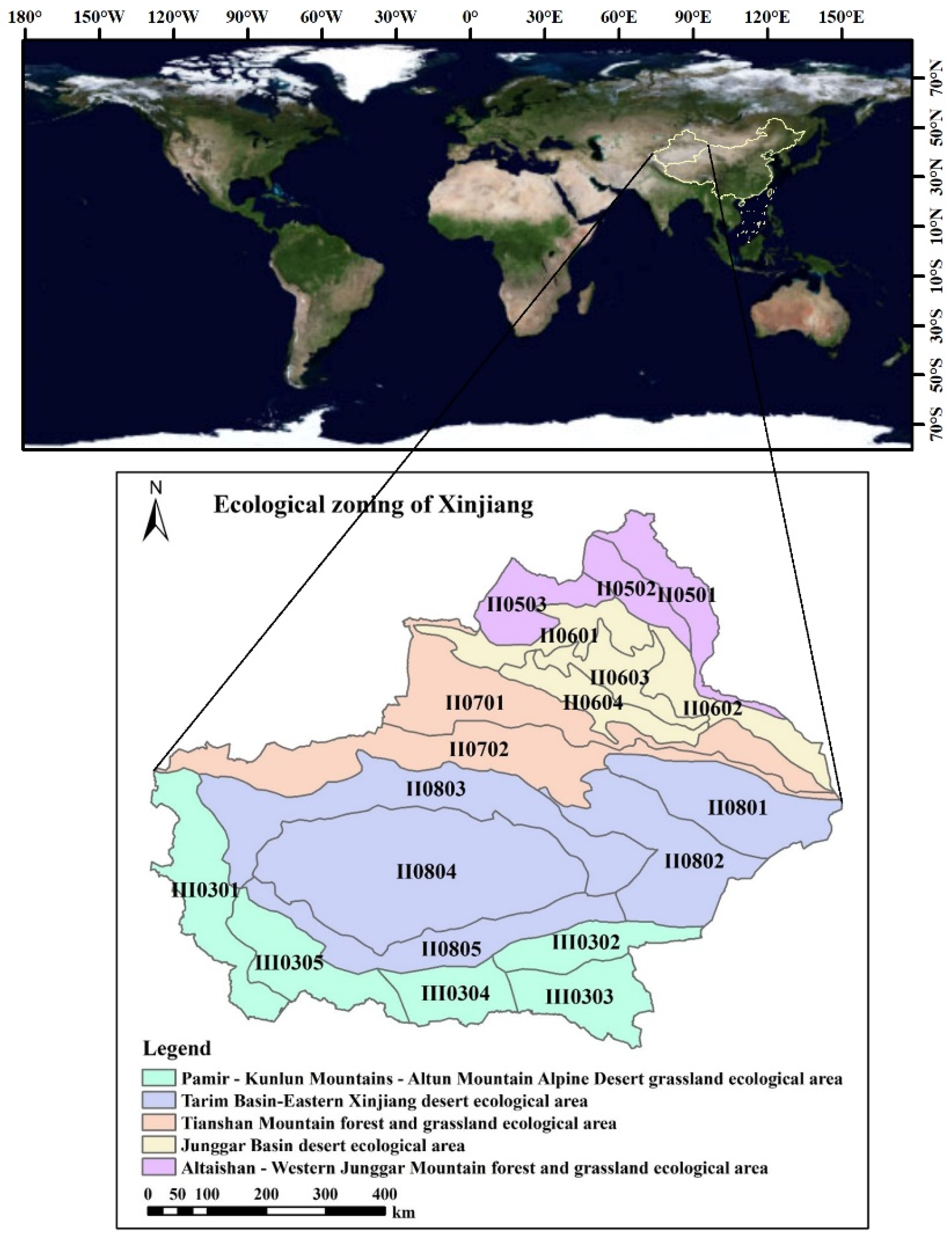
Study Area
2. Methodology
2.1. Data Sources
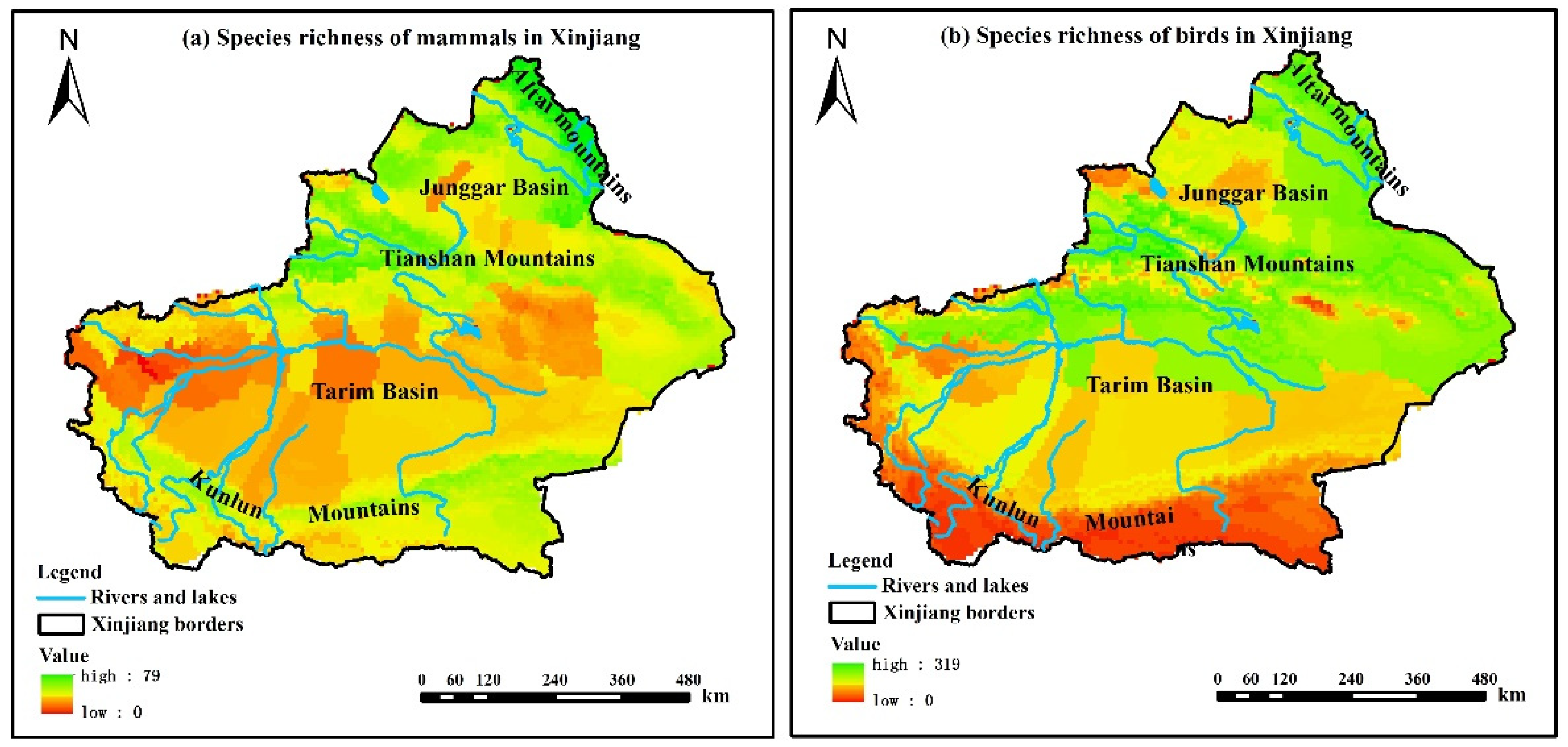
2.1.1. Species Richness Data
2.1.2. Remote Sensing Data
2.1.3. Ecological Function Zoning Data
2.2. Research Method
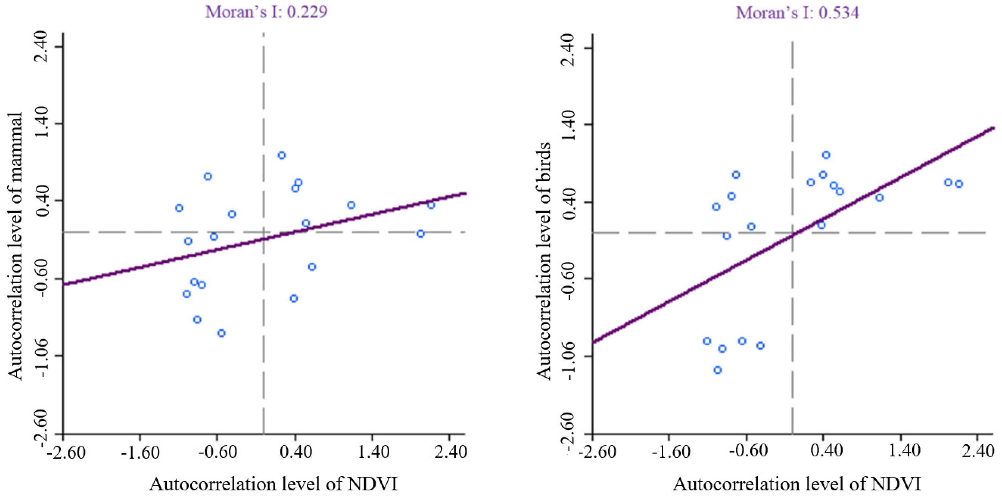
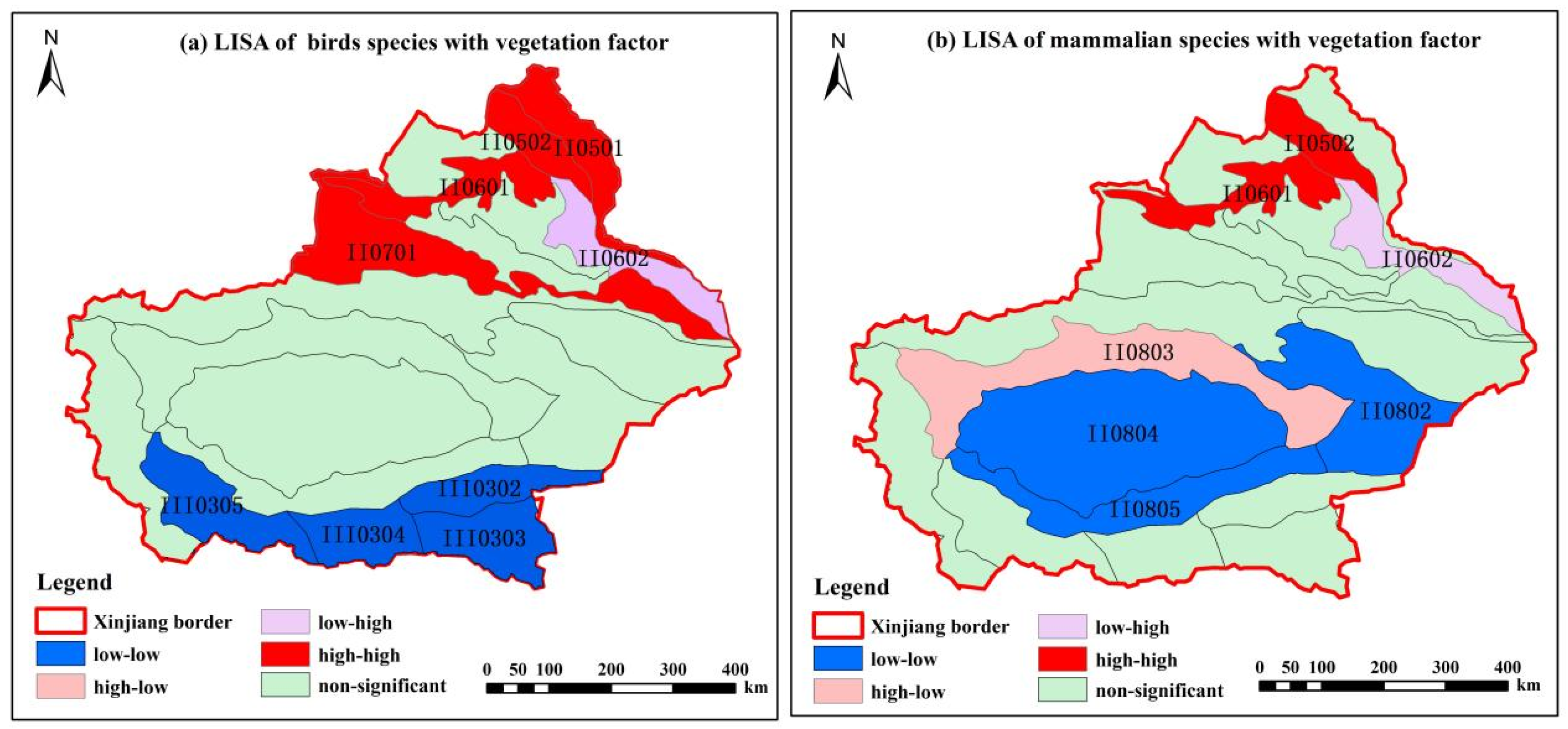
2.2.1. Bivariate Spatial Autocorrelation Analysis
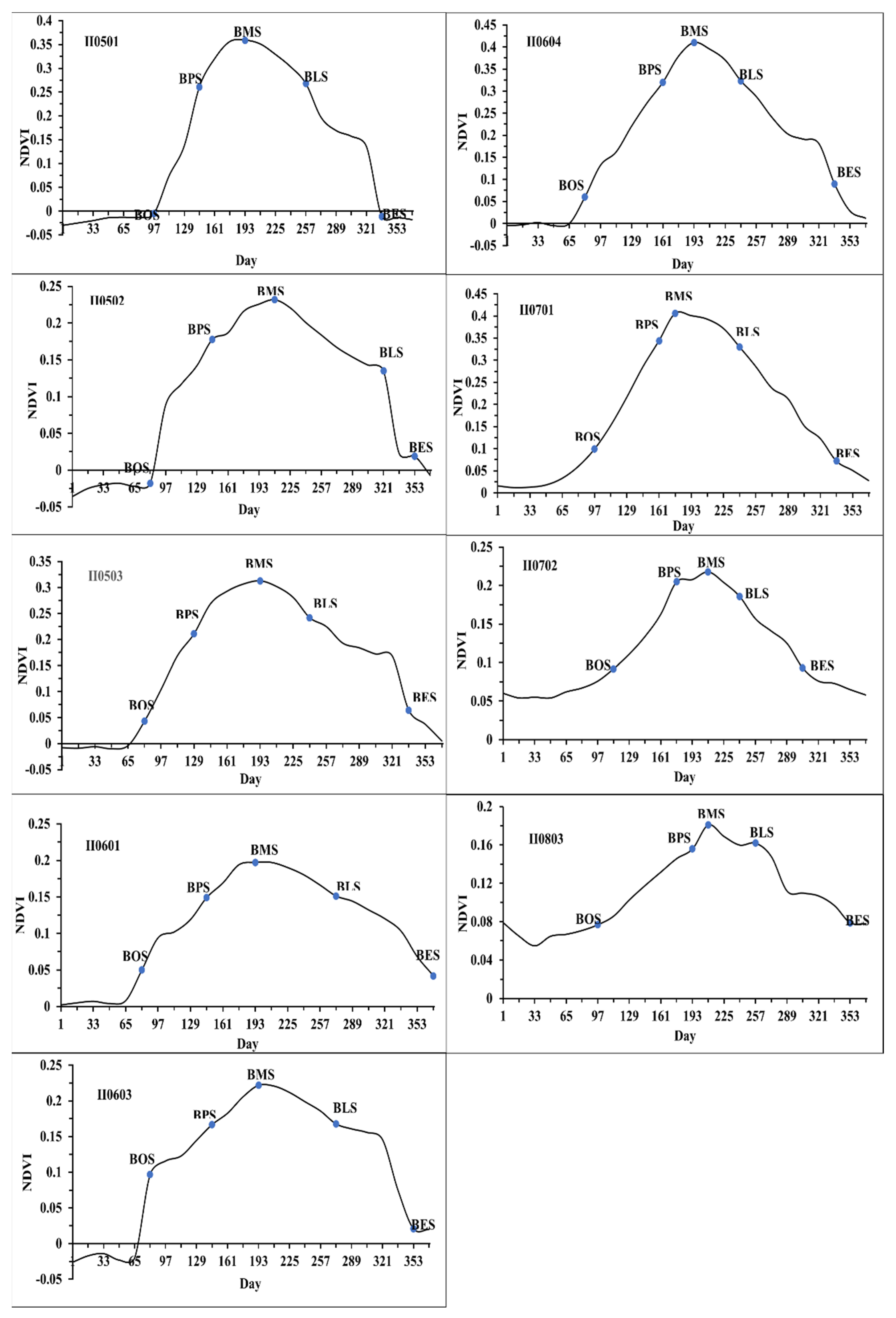
2.2.2. Dynamic Threshold Method of Vegetation Phenology
- (1)
- Mean value of vegetation growth season, maturity season, and withered season:
- (2)
- Vegetation annual difference value:
- (3)
- Vegetation annual cumulative value
- (4)
- Vegetation annual standard deviation
2.2.3. GeoDetector Method
3. Results
3.1. Analysis of the Spatial Pattern Relationship between Species Richness and Vegetation Factors
3.2. Analysis of Remote Sensing Vegetation Parameters and Vegetation Phenological Characteristics
3.3. Analysis of the Relationship between Vegetation Phenological Characteristic Parameters and Species Richness
4. Discussion
4.1. Spatial Pattern Relationship between Species Richness and Vegetation Factors
4.2. Analysis of Vegetation Parameters and the Phenological Characteristics of Remote Sensing
4.3. Analysis of the Relationship between Vegetation Phenological Characteristic Parameters and Species Richness
4.4. Limitations and Future Research
5. Conclusions
Author Contributions
Funding
Institutional Review Board Statement
Informed Consent Statement
Conflicts of Interest
Appendix A

| Number | Ecological Area | Ecological Subregions |
|---|---|---|
| II0501 | Altaishan—Western Junggar Mountain forest and grassland ecological area | Ecological subregion of larch forest of Siberia on the southern slope of altai mountain |
| II0502 | Altaishan—Western Junggar Mountain forest and grassland ecological area | Ecological subregion of Ertysi—wulungu river desert steppe |
| II0503 | Altaishan—Western Junggar Mountain forest and grassland ecological area | Ecological subregion of Mountain grassland in the western Junggar basin |
| II0601 | Junggar Basin desert ecological area | Desert—oasis agro-ecological subregion in the western margin of Junggar basin |
| II0602 | Junggar Basin desert ecological area | Ecological subregion of shrub desert in the eastern junggar basin |
| II0603 | Junggar Basin desert ecological area | Ecological subregion of Fixed and semi-fixed desert in the central Junggar Basin |
| II0604 | Junggar Basin desert ecological area | Agro-ecological subregion of shrub and semi-shrub desert and oasis in southern Junggar Basin |
| II0701 | Tianshan Mountain forest and grassland ecological area | Ecological subregion of Spruce forest-grassland on the Northern Slope of Tianshan Mountains |
| II0702 | Tianshan Mountain forest and grassland ecological area | Agro-ecological subregion of desert steppe and oasis on the southern slope of Tianshan Mountains |
| II0801 | Tarim Basin Eastern Xinjiang desert ecological area | Ecological subregion of desert oasis and Agroecological in Turpan Hami Basin |
| II0802 | Tarim Basin-Eastern Xinjiang desert ecological area | Eastern Xinjiang gobi—mobile desert ecological subregion |
| II0803 | Tarim Basin-Eastern Xinjiang desert ecological area | Desert—oasis agro-ecological subregion in northern Tarim basin |
| II0804 | Tarim Basin-Eastern Xinjiang desert ecological area | Taklimakan Desert ecological subregion |
| II0805 | Tarim Basin Eastern Xinjiang desert ecological area | Desert—oasis agro-ecological subregion in southern Tarim basin |
| III0301 | Pamir—Kunlun Mountains—Altun Mountain Alpine Desert grassland ecological area | Ecological subregion of alpine desert steppe in the Pamir Karakoram Mountains |
| III0302 | Pamir—Kunlun Mountains—Altun Mountain Alpine Desert grassland ecological area | Desert ecological sub-area of Altun Mountain |
| III0303 | Pamir—Kunlun Mountains—Altun Mountain Alpine Desert grassland ecological area | The ecological subregion of alpine desert steppe in the eastern part of Kunlun mountains |
| III0304 | Pamir—Kunlun Mountains—Altun Mountain Alpine Desert grassland ecological area | The ecological subregion of alpine desert steppe in the middle part of Kunlun mountains |
| III0305 | Pamir—Kunlun Mountains—Altun Mountain Alpine Desert grassland ecological area | The ecological subregion of alpine desert steppe in the west part of Kunlun mountains |
References
- Jiang, Z.; Ma, K.; Han, X. Conservation Biology; Zhejiang Science and Technology Press: Hangzhou, China, 1997. [Google Scholar]
- Gaston, K.J. Global patterns in biodiversity. Nature 2000, 405, 220–227. [Google Scholar] [CrossRef] [PubMed]
- Kennedy, T.A.; Naeem, S.; Howe, K.M.; Knops, J.; Tilman, D.; Reich, P.J.N. Biodiversity as a barrier to ecological invasion. Nature 2002, 417, 636–638. [Google Scholar] [CrossRef] [PubMed]
- Chapin, F.S., 3rd; Zavaleta, E.S.; Eviner, V.T.; Naylor, R.L.; Vitousek, P.M.; Reynolds, H.L.; Hooper, D.U.; Lavorel, S.; Sala, O.E.; Hobbie, S.E.; et al. Consequence of changing biodiversity. Nature 2000, 405, 232–242. [Google Scholar]
- Mckinney, M.L.J.B. Urbanization, Biodiversity, and Conservation. BioScience 2002, 52, 883–890. [Google Scholar] [CrossRef]
- Iii, F.; Zavaleta, E.S.; Eviner, V.T.; Naylor, R.L.; Vitousek, P.M.; Reynolds, H.L.; Hooper, D.U.; Lavorel, S.; Sala, O.E.; Hobbie, S.E.J.B. Consequences of changing biodiversity. Nature 1998, 48, 45–52. [Google Scholar]
- Van Strien, A.J.; Meyling, A.W.G.; Herder, J.E.; Hollander, H.; Kalkman, V.J.; Poot, M.J.M.; Turnhout, S.; van der Hoorn, B.; van Strien-van Liempt, W.T.F.H.; van Swaay, C.A.M.; et al. Modest recovery of biodiversity in a western European country: The Living Planet Index for the Netherlands. Biol. Conserv. 2016, 200, 44–50. [Google Scholar] [CrossRef] [Green Version]
- Liu, H. Response Mechanism of Species Diversity to Spatiotemporal Heterogeneity of Habitat Destruction; Nanjing Normal University: Nanjing, China, 2006. [Google Scholar]
- Willis, K.J.; Whittaker, R.J. Species diversity—Scale matters. Science 2002, 295, 1245–1248. [Google Scholar] [CrossRef]
- Rosenzweig, M.L. Species Diversity in Space and Time; Cambridge University Press: Cambridge, UK, 1995. [Google Scholar]
- Durnota, B. An Abstract Object Model of an Animal’s Environment. Ecol. Model. 1996, 86, 119–123. [Google Scholar] [CrossRef]
- Tarsitano, E. Interaction Between the Environment and Animals in Urban Settings: Integrated and Participatory Planning. Environ. Manag. 2006, 38, 799–809. [Google Scholar] [CrossRef]
- Braaker, S.; Moretti, M.; Boesch, R.; Ghazoul, J.; Obrist, M.K.; Bontadina, F. Assessing habitat connectivity for ground-dwelling animals in an urban environment. Ecol. Appl. 2014, 24, 1583–1595. [Google Scholar] [CrossRef]
- Shugart, L.R.; Mccarthy, J.F.; Halbrook, R.S. Biological Markers of Environmental and Ecological Contamination: An Overview. Risk Anal. 1992, 12, 353–360. [Google Scholar] [CrossRef]
- Mwendera, E.J.; Saleem, M.A.M. Vegetation Dynamics of Sloping Lands under Different Grazing Pressures in the Highlands of Ethiopia. UNISWA Res. J. Agric. Sci. Technol. 2000, 4, 44–54. [Google Scholar] [CrossRef] [Green Version]
- Milanovich, J.R.; Peterman, W.E.; Barrett, K.; Hopton, M.E. Do species distribution models predict species richness in urban and natural green spaces? A case study using amphibians. Landsc. Urban Plan. 2012, 107, 409–418. [Google Scholar] [CrossRef]
- Li, L.; Nurbay, A.; Wang, S.; Wang, Z.; Tang, Z. Hydrothermal interpretation of the distribution pattern of species richness of wild vascular plants in Xinjiang. Arid Zone Res. 2011, 28, 25–30. [Google Scholar] [CrossRef]
- Nagendra, H.; Lucas, R.; Honrado, J.P.; Jongman, R.H.G.; Tarantino, C.; Adamo, M.; Mairota, P. Remote sensing for conservation monitoring: Assessing protected areas, habitat extent, habitat condition, species diversity, and threats. Ecol. Indic. 2013, 33, 45–59. [Google Scholar] [CrossRef]
- Jha, C.S.; Goparaju, L.; Tripathi, A.; Gharai, B.; Singh, J.S. Forest fragmentation and its impact on species diversity: An analysis using remote sensing and GIS. Biodivers. Conserv. 2005, 14, 1681–1698. [Google Scholar] [CrossRef]
- Mohamed, A. Spatial Modeling of Site Productivty and Plant Species Diversity Using Remote Sensing and Geographical Information System; Colorado State University: Fort Collins, CO, USA, 2011. [Google Scholar]
- Fu, Y.H.; Piao, S.; Op de Beeck, M.; Cong, N.; Zhao, H.; Zhang, Y.; Menzel, A.; Janssens, I.A. Recent spring phenology shifts in western Central Europe based on multiscale observations. Glob. Ecol. Biogeogr. 2014, 23, 1255–1263. [Google Scholar]
- Dunn, P.O.; Møller, A.P. Changes in breeding phenology and population size of birds. J. Anim. Ecol. 2014, 83, 729–739. [Google Scholar] [CrossRef]
- John, R.; Chen, J.; Lu, N.; Guo, K.; Liang, C.; Wei, Y.; Noormets, A.; Ma, K.; Han, X.-G. Predicting plant diversity based on remote sensing products in the semi-arid region of Inner Mongolia. Remote Sens. Environ. 2008, 112, 2018–2032. [Google Scholar]
- Waring, R.H.; Coops, N.C.; Fan, W.; Nightingale, J.M. MODIS enhanced vegetation index predicts tree species richness across forested ecoregions in the contiguous U.S.A. Remote Sens. Environ. 2006, 103, 218–226. [Google Scholar]
- Krishnaswamy, J.; Bawa, K.S.; Ganeshaiah, K.N.; Kiran, M.C. Quantifying and mapping biodiversity and ecosystem services: Utility of a multi-season NDVI based Mahalanobis distance surrogate. Remote Sens. Environ. 2009, 113, 857–867. [Google Scholar] [CrossRef]
- Viña, A.; Gitelson, A.A. New developments in the remote estimation of the fraction of absorbed photosynthetically active radiation in crops. Geophys. Res. Lett. 2005, 32, 131–149. [Google Scholar] [CrossRef] [Green Version]
- Myneni, R.B.; Ramakrishna, R.; Nemani, R.; Running, S.W. Estimation of global leaf area index and absorbed par using radiative transfer models. IEEE Trans. Geosci. Remote Sens. 2002, 35, 1380–1393. [Google Scholar] [CrossRef] [Green Version]
- Zeng, X.; Rao, P.; Defries, R.S.; Hansen, M.C. Interannual Variability and Decadal Trend of Global Fractional Vegetation Cover from 1982 to 2000. J. Appl. Meteorol. 2003, 42, 1525–1530. [Google Scholar] [CrossRef]
- Myers, N.; Mittermeier, R.A.; Mittermeier, C.G.; da Fonseca, G.A.; Kent, J. Biodiversity hotspots for conservation priorities. Nature 2000, 403, 853–858. [Google Scholar] [CrossRef]
- Wu, J.; Chen, B.; Reynolds, G.; Xie, J.; Liang, S.; O’Brien, M.J.; Hector, A. Chapter Three—Monitoring tropical forest degradation and restoration with satellite remote sensing: A test using Sabah Biodiversity Experiment. In Advances in Ecological Research; Dumbrell, A.J., Turner, E.C., Fayle, T.M., Eds.; Academic Press: Cambridge, MA, USA, 2020; Volume 62, pp. 117–146. [Google Scholar]
- Skidmore, A.K.; Coops, N.C.; Neinavaz, E.; Ali, A.; Schaepman, M.E.; Paganini, M.; Kissling, W.D.; Vihervaara, P.; Darvishzadeh, R.; Feilhauer, H.; et al. Priority list of biodiversity metrics to observe from space. Nat. Ecol. Evol. 2021, 5, 896–906. [Google Scholar] [CrossRef]
- Middleton, A.D.; Kauffman, M.J.; McWhirter, D.E.; Cook, J.G.; Cook, R.C.; Nelson, A.A.; Jimenez, M.D.; Klaver, R.W. Animal migration amid shifting patterns of phenology and predation: Lessons from a Yellowstone elk herd. Ecology 2013, 94, 1245–1256. [Google Scholar] [CrossRef]
- Dong, W.; Cui, B.; Liu, Z.; Zhang, K. Relative effects of human activities and climate change on the river runoff in an arid basin in northwest China. Hydrol. Process. 2014, 28, 4854–4864. [Google Scholar] [CrossRef]
- Yao, J.; Zhao, Y.; Chen, Y.; Yu, X.; Zhang, R. Multi-scale assessments of droughts: A case study in Xinjiang, China. Sci. Total Environ. 2018, 630, 444–452. [Google Scholar] [CrossRef]
- Luo, M.; Liu, T.; Meng, F.; Duan, Y.; Bao, A.; Xing, W.; Feng, X.; De Maeyer, P.; Frankl, A. Identifying climate change impacts on water resources in Xinjiang, China. Sci. Total Environ. 2019, 676, 613–626. [Google Scholar] [CrossRef]
- Tang, H.; Yan, L.; Zhang, X. Biodiversity conservation and a conception for a national desert park in Dzungaria Basin, Xinjiang. Biodivers. Sci. 2008, 16, 618. [Google Scholar]
- Yuan, G. Distribution and Evaluation of Biodiversity in Xinjiang; Xinjiang Science and Technology Press: Xinjiang, China, 2012; Volume 13, pp. 231–249. [Google Scholar]
- Chen, Y.; Zhang, H.; Li, W.; Chen, Y. Relationship between species diversity and groundwater level in the lower reaches of Tarim River in Xinjiang. Adv. Earth Sci. 2005, 2, 158–165. [Google Scholar]
- Yuan, G.; Chen, L.; Cheng, J. Investigation and evaluation of biodiversity in Xinjiang. Environ. Prot. Xinjiang 2010, 32, 1–6. [Google Scholar]
- Xue, Y.; Han, P.; Feng, G. Change Trend of the Precipitation and Air Temperature in Xinjiang since Recent 50 Years. Arid Zone Res. 2003, 20, 49–52. [Google Scholar]
- Chen, Y.; Xu, C.; Yang, Y.; Hao, X.; Shen, Y. Change of hydrology and water resources in Xinjiang and its response to regional climate change. Acta Geogr. Sin. 2009, 64, 1331–1341. [Google Scholar]
- Ma, M. List of Birds in Xinjiang; Science Press: Beijing, China, 2001. [Google Scholar]
- Abulimiti, Y. List of Mammals in Xinjiang; Data before 2010; Xinjiang Institute of Ecology and Geography; Chinese Academy of Sciences: Beijing, China, 2002. [Google Scholar]
- Li, L.; Yin, L.; Tang, Z. Distribution pattern of species richness of wild animals and plants in Xinjiang. Study Arid Area 2011, 28, 1–9. [Google Scholar]
- Liu, Y.; Ju, W.; Chen, J.; Zhu, G.; Xing, B.; Zhu, J.; He, M. Spatiotemporal variation characteristics of forest leaf area index in China from 2000 to 2010. Sci. Bull. 2012, 57, 1435. [Google Scholar]
- Xiao, Z.; Liang, S.; Wang, J.; Chen, P.; Yin, X.; Zhang, L.; Song, J. Sensing, R. Use of General Regression Neural Networks for Generating the GLASS Leaf Area Index Product From Time-Series MODIS Surface Reflectance. IEEE Trans. Geosci. Remote Sens. 2013, 52, 209–223. [Google Scholar] [CrossRef]
- Liu, Y.; Zhou, J. Comparison of MODIS, CYCLOPES and GLASS in Hanjiang River Basin. Remote Sens. Land Resour. 2018, 30, 14–21. [Google Scholar]
- Liang, S.; Zhao, X.; Liu, S.; Yuan, W.; Cheng, X.; Xiao, Z.; Zhang, X.; Liu, Q.; Cheng, J.; Tang, H.; et al. A long-term Global LAnd Surface Satellite (GLASS) data-set for environmental studies. Int. J. Digit. Earth 2013, 6 (Suppl. S1), 5–33. [Google Scholar] [CrossRef]
- Mccallum, I.; Wagner, W.; Schmullius, C.; Shvidenko, A.; Obersteiner, M.; Fritz, S.; Nilsson, S. Comparison of four global FAPAR datasets over Northern Eurasia for the year 2000. Remote Sens. Environ. 2010, 114, 941–949. [Google Scholar] [CrossRef]
- Xiao, Z.; Liang, S.; Wang, T.; Jiang, B. Retrieval of Leaf Area Index (LAI) and Fraction of Absorbed Photosynthetically Active Radiation (FAPAR) from VIIRS Time-Series Data. Remote Sens. 2016, 8, 351. [Google Scholar] [CrossRef] [Green Version]
- Xiao, Z.; Liang, S.; Sun, R. Evaluation of Three Long Time Series for Global Fraction of Absorbed Photosynthetically Active Radiation (FAPAR) Products. IEEE Trans. Geosci. Remote Sens. 2018, 56, 5509–5524. [Google Scholar] [CrossRef]
- Xiao, Z.; Liang, S.; Sun, R.; Wang, J.; Jiang, B. Estimating the fraction of absorbed photosynthetically active radiation from the MODIS data based GLASS leaf area index product. Remote Sens. Environ. 2015, 171, 105–117. [Google Scholar] [CrossRef]
- Xiao, Z.; Wang, T.; Liang, S.; Sun, R. Estimating the Fractional Vegetation Cover from GLASS Leaf Area Index Product. Remote Sens. 2016, 8, 337. [Google Scholar] [CrossRef] [Green Version]
- Mu, X.; Huang, S.; Ren, H.; Yan, G.; Song, W.; Ruan, G. Validating GEOV1 Fractional Vegetation Cover Derived From Coarse-Resolution Remote Sensing Images Over Croplands. IEEE J. Sel. Top. Appl. Earth Obs. Remote Sens. 2014, 8, 439–446. [Google Scholar] [CrossRef]
- Liu, D.; Jia, K.; Wei, X.; Xia, M.; Wang, B. Spatiotemporal Comparison and Validation of Three Global-Scale Fractional Vegetation Cover Products. Remote Sens. 2019, 11, 2524. [Google Scholar] [CrossRef] [Green Version]
- Jia, K.; Liang, S.; Wei, X.; Yao, Y.; Yang, L.; Zhang, X.; Liu, D. Validation of Global LAnd Surface Satellite (GLASS) fractional vegetation cover product from MODIS data in an agricultural region. Remote Sens. Lett. 2018, 9, 847–856. [Google Scholar] [CrossRef]
- Wang, Z.X.; Liu, C.; Huete, A. From AVHRR-NDVI to MODIS-EVI: Advances in vegetation index research. Acta Ecol. Sin. 2003, 23, 979–987. [Google Scholar]
- Jing, W.; Ni, G.; Wang, X.; Jia, Y. Comparisons of normalized difference vegetation index from MODIS Terra and Aqua data in northwestern China. In Proceedings of the IEEE International Geoscience & Remote Sensing Symposium, Boston, MA, USA, 6–11 July 2008. [Google Scholar]
- Verbyla, D. Comparison of eMODIS and MOD/MYD13A2 NDVI products during 2012–2014 spring green-up periods in Alaska and northwest Canada. Int. J. Appl. Earth Obs. Geoinf. 2015, 36, 83–86. [Google Scholar] [CrossRef]
- Kern, A.; Marjanović, H.; Bognár, P.; Pásztor, S.; Barcza, Z. Applications of a MODIS-adjusted NDVI3g dataset in Central Europe between 1982 and 2013. In Proceedings of the Egu General Assembly Conference, Vienna, Austria, 23–28 April 2017. [Google Scholar]
- Wang, G.J.; Huang, J.L.; Xiao, F.; Feng, Q.J.R.; Basin, E.I.T.Y. Comparison of AVHRR NDVI and MODIS NDVI Data Products Based on Association and Trend Analysis. Resources and Environment in the Yangtze Basin. 2018. Available online: http://yangtzebasin.whlib.ac.cn/EN/article/showNewArticle.do (accessed on 17 July 2021).
- Abdi, O.; Shirvani, Z.; Buchroithner, M.F. Visualization and quantification of significant anthropogenic drivers influencing rangeland degradation trends using Landsat imagery and GIS spatial dependence models:A case study in Northeast Iran. J. Geogr. Sci. 2018, 28, 1933–1952. [Google Scholar]
- Xie, Y.; Zhang, S.; Lin, B.; Zhao, Y.; Hu, B. Spatial division of land ecological restoration in Guangxi county based on the relationship between supply and demand of ecosystem services. J. Nat. Resour. 2020, 35, 217–229. [Google Scholar]
- Yuan, J.; Kang, M.; Liu, S.; Tian, L.; Lei, M. A study on the vegetation in the east side of Helan Mountain. Plant Ecol. 2000, 149, 119–130. [Google Scholar] [CrossRef]
- Ren, S.; Chen, X.; An, S. Assessing plant senescence reflectance index-retrieved vegetation phenology and its spatiotemporal response to climate change in the Inner Mongolian Grassland. Int. J. Biometeorol. 2017, 61, 601–612. [Google Scholar] [CrossRef]
- Gao, J.; Jiao, K.; Wu, S.J. Investigating the spatially heterogeneous relationships between climate factors and NDVI in China during 1982 to 2013. J. Geogr. Sci. 2019, 29, 1597–1609. [Google Scholar] [CrossRef] [Green Version]
- Jnsson, P.; Eklundh, L. Geosciences. TIMESAT—A program for analyzing time-series of satellite sensor data. Comput. Geosci. 2004, 30, 833–845. [Google Scholar] [CrossRef] [Green Version]
- Li, C.; Deng, F.; Zhang, J.; Wang, X.; Wei, W. Ma Qingxiao. Analysis of phenological spatial characteristics in Hubei Province Based on time series vegetation index. Resour. Environ. Yangtze River Basin 2019, 28, 1583–1589. [Google Scholar]
- DeFries, R.S. NDVI-derived land cover classification at a global scale. Int. J. Remote Sens. 1994, 15, 3567–3586. [Google Scholar]
- Zhang, X.; Wu, S.; Yan, X.; Chen, Z. A global classification of vegetation based on NDVI, rainfall and temperature. Int. J. Climatol. 2017, 37, 2318–2324. [Google Scholar] [CrossRef]
- Pu, R.; Gong, P.; Tian, Y.; Miao, X.; Anderson, G.L. Using classification and NDVI differencing methods for monitoring sparse vegetation coverage: A case study of Saltcedar in Nevada, USA. Int. J. Remote Sens. 2008, 29, 3987–4011. [Google Scholar] [CrossRef]
- Wang, J.; Xu, J. Geographical detector: Principle and Prospect. Acta Geogr. Sin. 2017, 72, 116–134. [Google Scholar]
- Su, Y.; Li, T.; Cheng, S.; Wang, X. Spatial distribution exploration and driving factor identification for soil salinisation based on geodetector models in coastal area. Ecol. Eng. 2020, 156, 105961. [Google Scholar] [CrossRef]
- Wei, W.; Samat, A.; Abuduwaili, J.; Ge, Y. Quantifying the influences of land surface parameters on LST variations based on GeoDetector model in Syr Darya Basin, Central Asia. J. Arid Environ. 2021, 186, 104415. [Google Scholar]
- Wu, J.; Liang, S. Developing an Integrated Remote Sensing Based Biodiversity Index for Predicting Animal Species Richness. Remote Sens. 2018, 10, 739. [Google Scholar] [CrossRef] [Green Version]
- Ding, P. Development and Current Situation of Bird Ecology in China. J. Zool. 2002, 3, 71–78. [Google Scholar]
- Sekercioglu, C.H. Conservation Ecology: Area Trumps Mobility in Fragment Bird Extinctions. Curr. Biol. CB 2007, 17, R283–R286. [Google Scholar] [CrossRef] [PubMed] [Green Version]
- Gómez, C.; Gómez-Bahamón, V.; Cárdenas-Ortíz, L.; Bayly, N.J. Distribution of Nearctic-Neotropical migratory birds along a South American elevation gradient during spring migration. Wilson J. Ornithol. 2015, 127, 72–86. [Google Scholar] [CrossRef]
- Benson, T.J.; Brown, J.D.; Anich, N.M.; Bednarz, J.C. Habitat availability for bottomland hardwood forest birds: The importance of considering elevation. J. Field Ornithol. 2011, 82, 25–31. [Google Scholar]
- Jeganathan, C.; Dash, J.; Atkinson, P.M. Remotely sensed trends in the phenology of northern high latitude terrestrial vegetation, controlling for land cover change and vegetation type. Remote Sens. Environ. 2014, 143, 154–170. [Google Scholar]
- Feng, J.; Dong, X.; Xu, C.; Cha, F. Effects of sampling scale on the latitudinal distribution pattern of seed plant species diversity in Northwest Yunnan. Biodiversity 2009, 17, 266–271. [Google Scholar]
- Long, C.; Wan, H.; Li, L.; Wang, J. Spatial Pattern and Relationship between Bird and Mammal Richness and Environmental Factors in Xinjiang. J. Remote Sens. 2019, 23, 155–165. [Google Scholar]
- Kerr, J.T.; Southwood, T.R.E.; Cihlar, J. Remotely sensed habitat diversity predicts butterfly species richness and community similarity in Canada. Proc. Natl. Acad. Sci. USA 2001, 98, 11365–11370. [Google Scholar] [CrossRef] [Green Version]
- Winter, M.; Johnson, D.H.; Shaffer, J.A. Variability in Vegetation Effects on Density and Nesting Success of Grassland Birds. J. Wildl. Manag. 2005, 69, 185–197. [Google Scholar] [CrossRef] [Green Version]
- Hasui, É.; Gomes, V.S.M.; Silva, W.R. Effects of vegetation traits on habitat preferences of frugivorous birds in Atlantic rain forest. Biotropica 2007, 39, 502–509. [Google Scholar] [CrossRef]
- Rosa, G.L. Effects of Vegetation Structure on the Habitat Use of Small Terrestrial Mammals at Camp Maxey; Texas, M.S., Stephen, F., Eds.; Austin State University: Nacogdoches, TX, USA, 2006. [Google Scholar]
- Abdullahi, H.A. Effects of Vegetation Disturbance on Small Mammals Diversity and Distribution in Oloolua Forest, Kenya. Master’s Thesis, University of Nairobi, Nairobi, Kenya, 2010. [Google Scholar]
- Thompson, C.M.; Gese, E.M. Influence of vegetation structure on the small mammal community in a shortgrass prairie ecosystem. Acta Theriol. 2013, 58, 55–61. [Google Scholar] [CrossRef]
- Xia, L.; Yang, Q.; Xiang, Y.; Feng, Z. Distribution Pattern and Zoogeographical Analysis of Mammals in Qilian Mountain Areas, Qinghai, China. Acta Theriol. Sin. 2006, 23, 295. [Google Scholar]
- Hou, L.; Ma, L. Glires of Eastern Xinjiang and Their Zoogeographical Distribution. Arid Zone Res. 1998, 3, 173–191. [Google Scholar]
| Data Type | Data Name | Data Sources | Time Resolution (d) | Spatial Resolution (km) | Time Span | Data Type |
|---|---|---|---|---|---|---|
| Species richness data | Species richness of birds/mammals | Literature query statistics | ** | 10 km | 2001–2010 | Grid |
| Remote sensing vegetation parameter data | LAI | GLASS LAI | 8 d | 1 km | 2001–2010 | Grid |
| FAPAR | GLASS FAPAR | 8 d | 1 km | 2001–2010 | Grid | |
| FVC | GLASS FVC | 8 d | 0.5 km | 2001–2010 | Grid | |
| NDVI | MOD13A2 NDVI C6 | 16 d | 1 km | 2001–2010 | Grid | |
| Ecological function zoning data | Ecological function zoning | China ecological function regionalization database | ** | ** | ** | Vector |
| Developmental Period | Definition | Symbol |
|---|---|---|
| Growing season | It starts from the time when the time series curve grows to 20% of the amplitude and ends at the time when it grows to 80%. Indicates the period of vegetation growth and development. | SOS—EOS |
| Mature season | It starts from the time when the time series curve grows to 80% of the amplitude and ends when it drops to 80% of the amplitude. Indicates the period of the maturing of the vegetation. | EOS—SOW |
| Withered season | It starts from the time when the time series curve drops to 80% of the amplitude, it ends when the time drops to 20% of the amplitude. Indicates the period of the withering of the vegetation. | SOW—EOW |
| Vegetation Parameter Index | Definitions |
|---|---|
| Growing season value of remote sensing vegetation parameter X | |
| Mature season value of remote sensing vegetation parameter X | |
| Withered season value of remote sensing vegetation parameter X | |
| Annual difference value of remote sensing vegetation parameter X | |
| Annual cumulative value of remote sensing vegetation parameter X | |
| Annual standard deviation value of remote sensing vegetation parameter X |
| Vegetation Parameters | Vegetation Phenological Characteristic Parameters | Bird q Value | Mammal q Value | Vegetation Parameters | Vegetation Phenological Characteristic Parameters | Bird q Value | Mammal q Value |
|---|---|---|---|---|---|---|---|
| NDVI | 0.059 * | 0.139 * | FVC | 0.064 * | 0.141 * | ||
| 0.076 * | 0.097 * | 0.053 | 0.100 | ||||
| 0.088 * | 0.142 * | 0.073 * | 0.120 * | ||||
| 0.037 * | 0.208 * | 0.086 * | 0.154 * | ||||
| 0.035 * | 0.243 * | 0.078 * | 0.136 * | ||||
| 0.042 * | 0.046 * | 0.077 * | 0.148 * | ||||
| FAPAR | 0.101 * | 0.169 * | LAI | 0.086 * | 0.179 * | ||
| 0.105 * | 0.188 * | 0.067 * | 0.122 * | ||||
| 0.103 * | 0.174 * | 0.098 * | 0.185 * | ||||
| 0.074 * | 0.198 * | 0.092 * | 0.158 * | ||||
| 0.070 * | 0.189 * | 0.090 * | 0.164 * | ||||
| 0.111 * | 0.199 * | 0.115 * | 0.178 * |
Publisher’s Note: MDPI stays neutral with regard to jurisdictional claims in published maps and institutional affiliations. |
© 2021 by the authors. Licensee MDPI, Basel, Switzerland. This article is an open access article distributed under the terms and conditions of the Creative Commons Attribution (CC BY) license (https://creativecommons.org/licenses/by/4.0/).
Share and Cite
Wu, J.; Li, H.; Wan, H.; Wang, Y.; Sun, C.; Zhou, H. Analyzing the Relationship between Animal Diversity and the Remote Sensing Vegetation Parameters: The Case of Xinjiang, China. Sustainability 2021, 13, 9897. https://doi.org/10.3390/su13179897
Wu J, Li H, Wan H, Wang Y, Sun C, Zhou H. Analyzing the Relationship between Animal Diversity and the Remote Sensing Vegetation Parameters: The Case of Xinjiang, China. Sustainability. 2021; 13(17):9897. https://doi.org/10.3390/su13179897
Chicago/Turabian StyleWu, Jinhui, Haoxin Li, Huawei Wan, Yongcai Wang, Chenxi Sun, and Hongmin Zhou. 2021. "Analyzing the Relationship between Animal Diversity and the Remote Sensing Vegetation Parameters: The Case of Xinjiang, China" Sustainability 13, no. 17: 9897. https://doi.org/10.3390/su13179897
APA StyleWu, J., Li, H., Wan, H., Wang, Y., Sun, C., & Zhou, H. (2021). Analyzing the Relationship between Animal Diversity and the Remote Sensing Vegetation Parameters: The Case of Xinjiang, China. Sustainability, 13(17), 9897. https://doi.org/10.3390/su13179897