
Dimensions of Urban Blight in Emerging Southern Cities: A Case Study of Accra-Ghana


Abstract
:1. Introduction
2. Urban Blight and Value Systems
2.1. The Phenomenon of Urban Blight
- “Irregularity of plots or parcels,
- Inadequacy of street in the vicinity,
- Lack of access to plots or habitable dwelling within the area,
- Diversity of existing use which makes development control difficult or impossible,
- Incompatibility with:
- The existing or proposed use
- The spatial development framework and
- The structure or local plan,
- Adverse impact on the environment,
- Overcrowding leading to unhealthy population density,
- Lack of sanitation, drainage or appropriate service,
- High incidence of crime which has been confirmed to be attributable to the type of development and
- Safety or restriction to other authorised users”
2.2. The Nuances of Urban Blight
2.3. The Perception of Values Attached to Urban Spaces
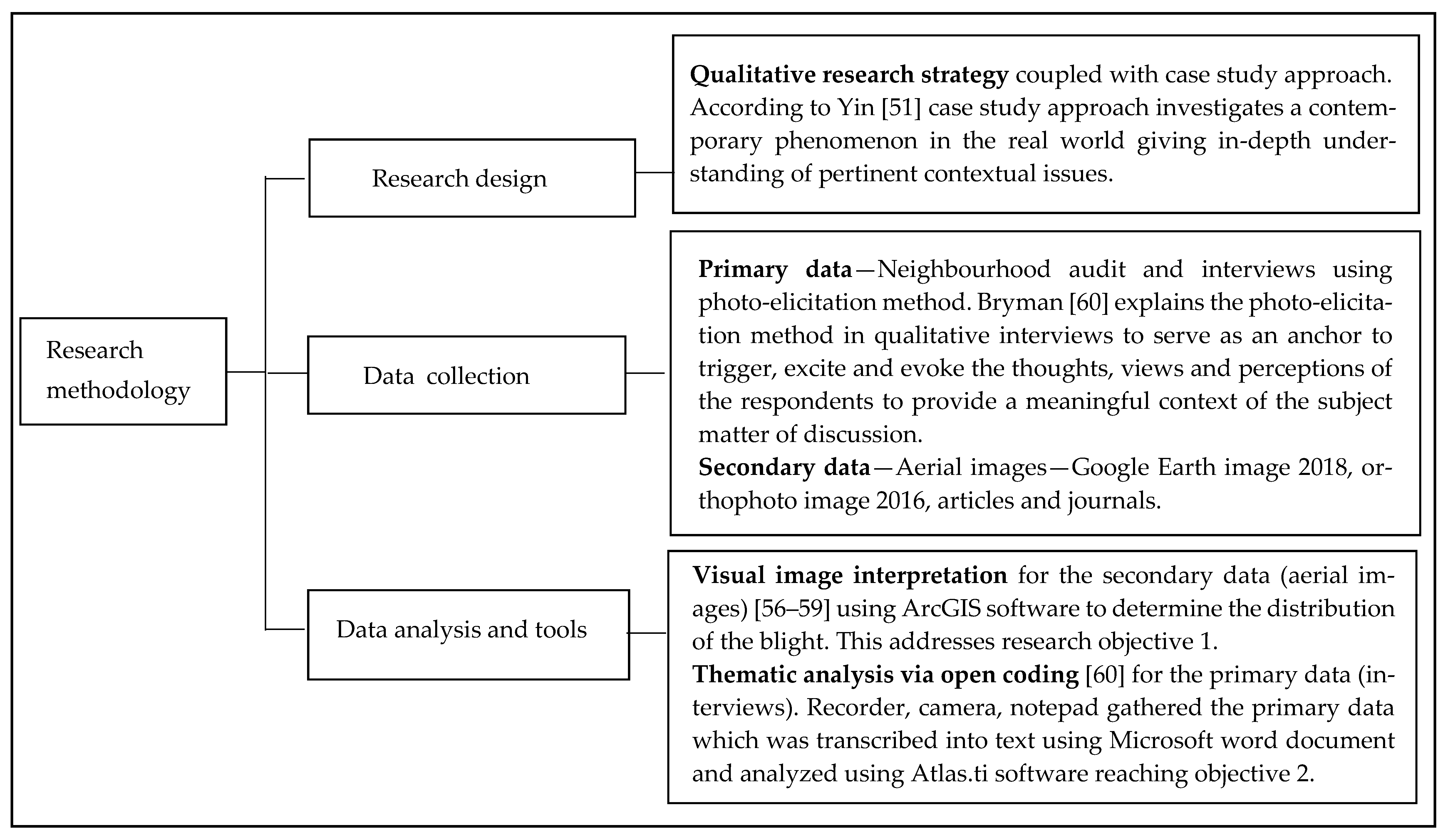
3. Methodology
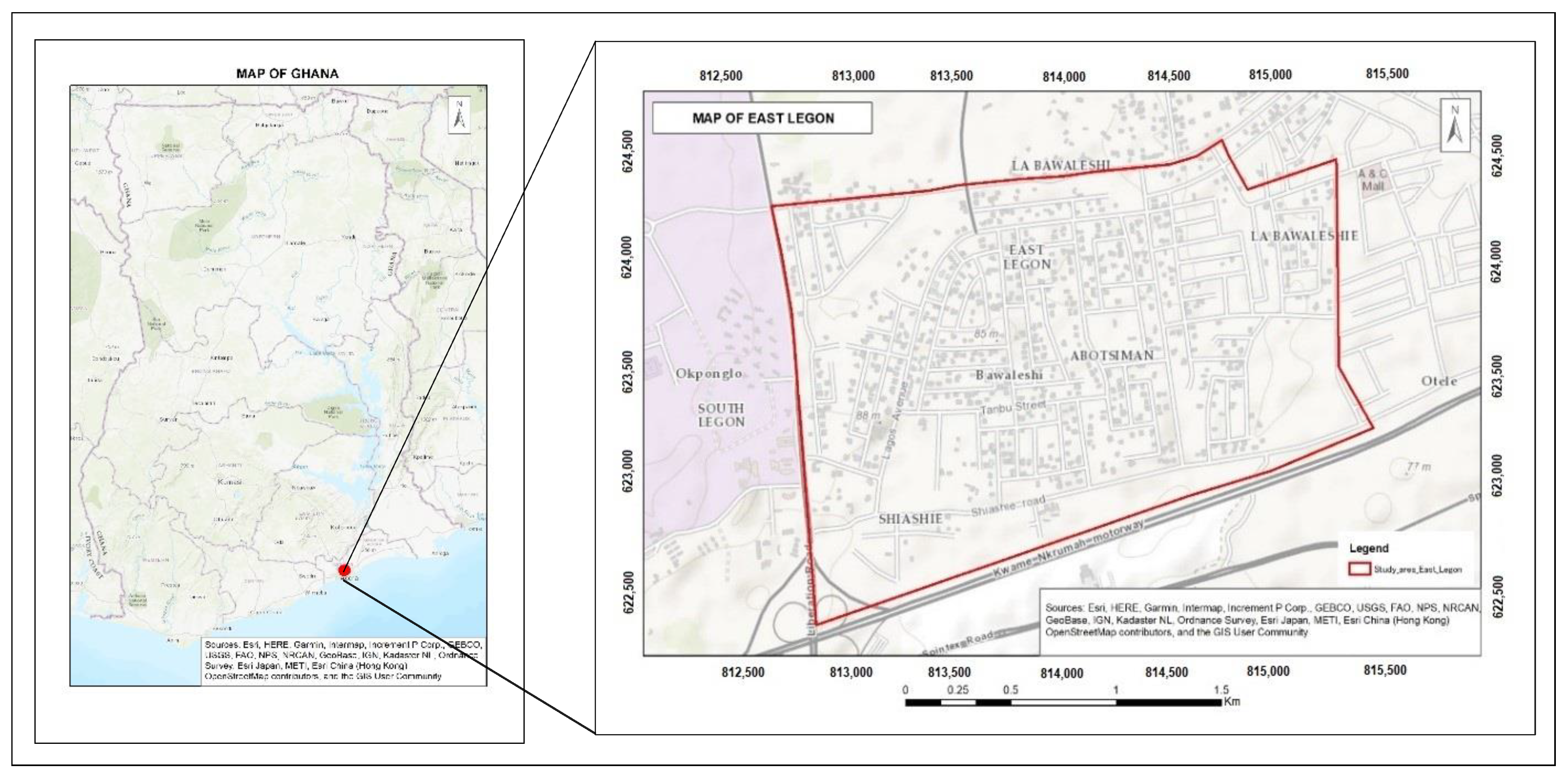
3.1. The Study Area
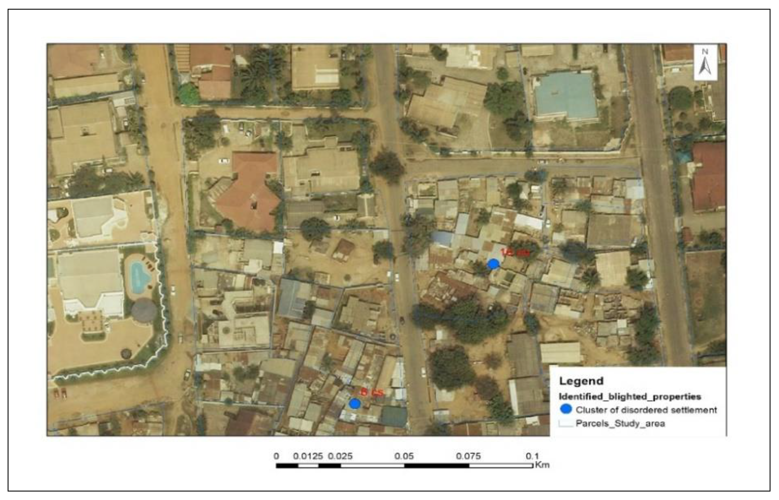
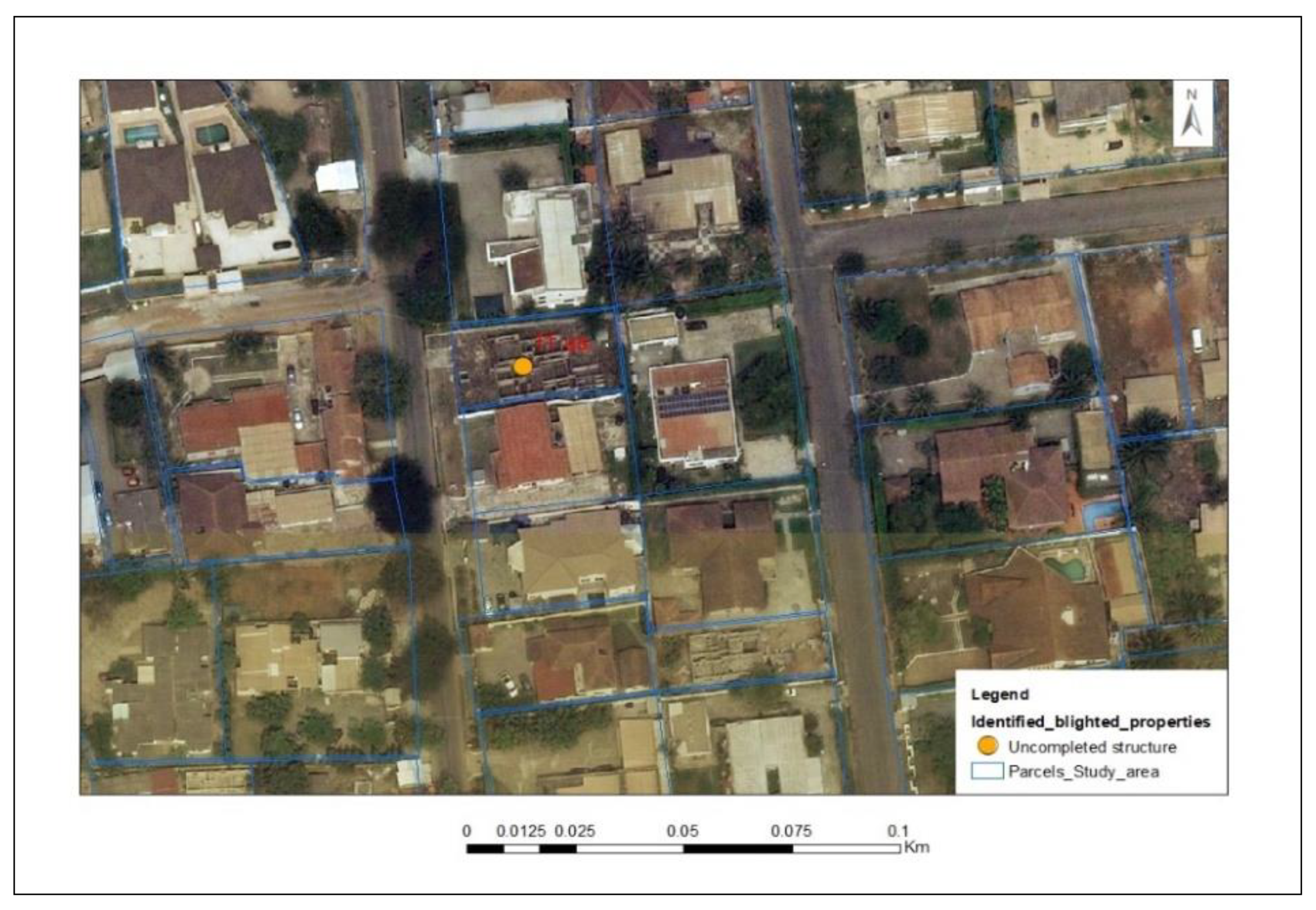
3.2. Criteria for Identifying Blighted Properties
3.2.1. The Aerial Views of the Four Forms of Urban Blight
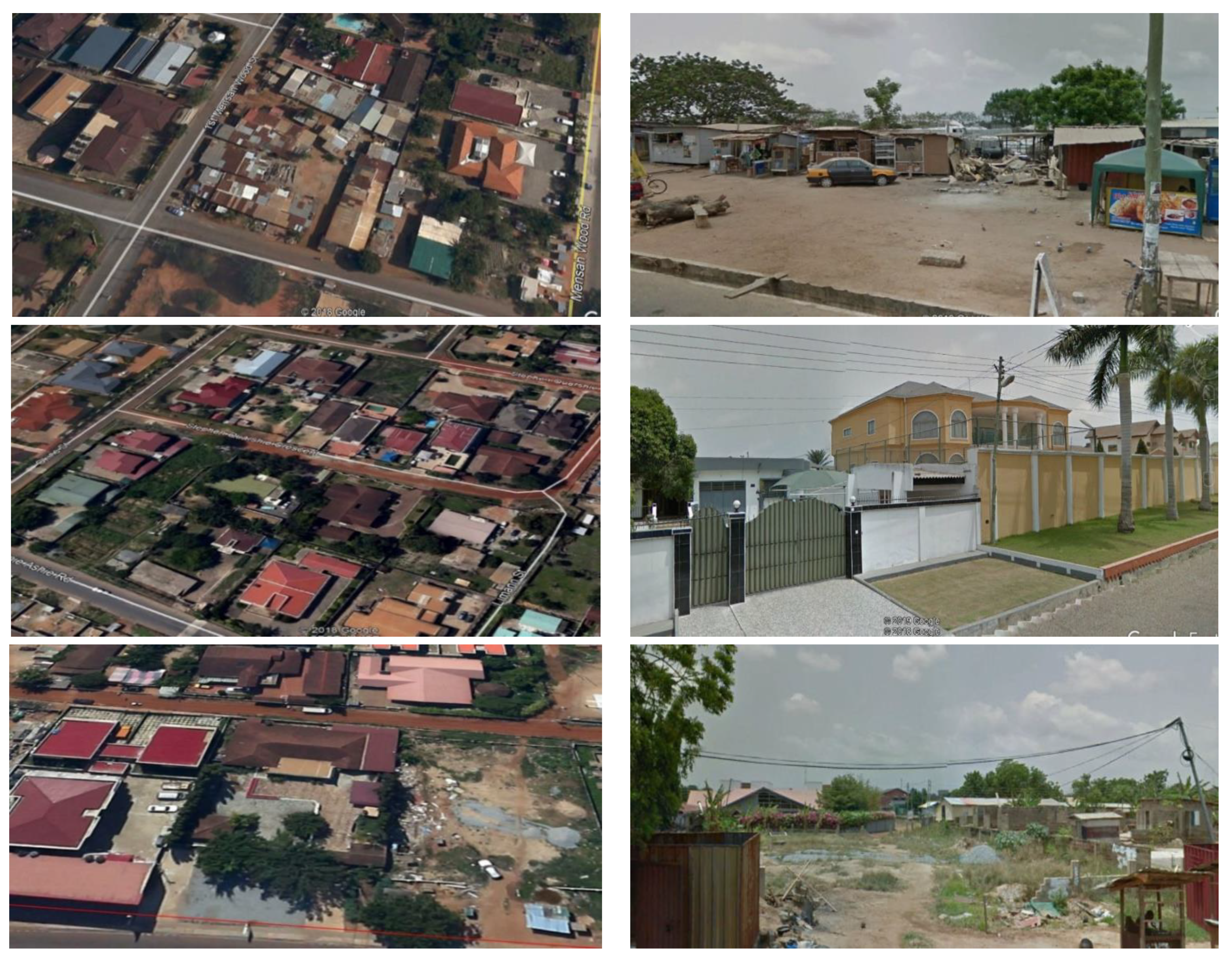
Cluster of Disordered Settlements
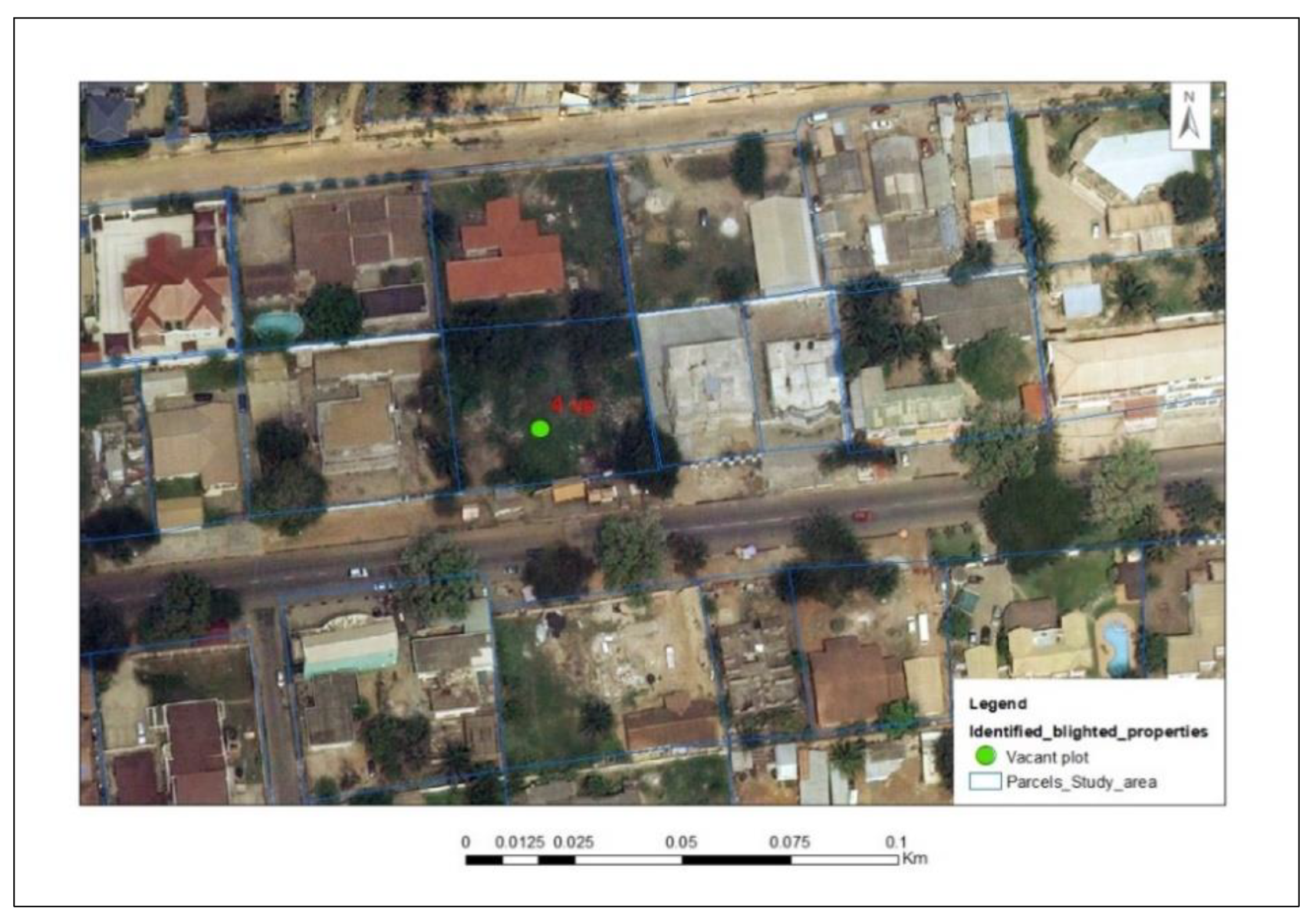
Vacant Plot of Land
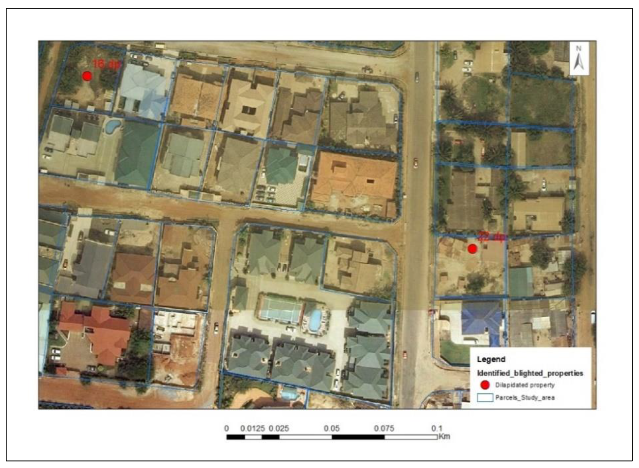
Single Dilapidated Property
Uncompleted Structures
3.3. Data Collection
3.4. Sampling Technique
3.5. Data Analysis
4. Results
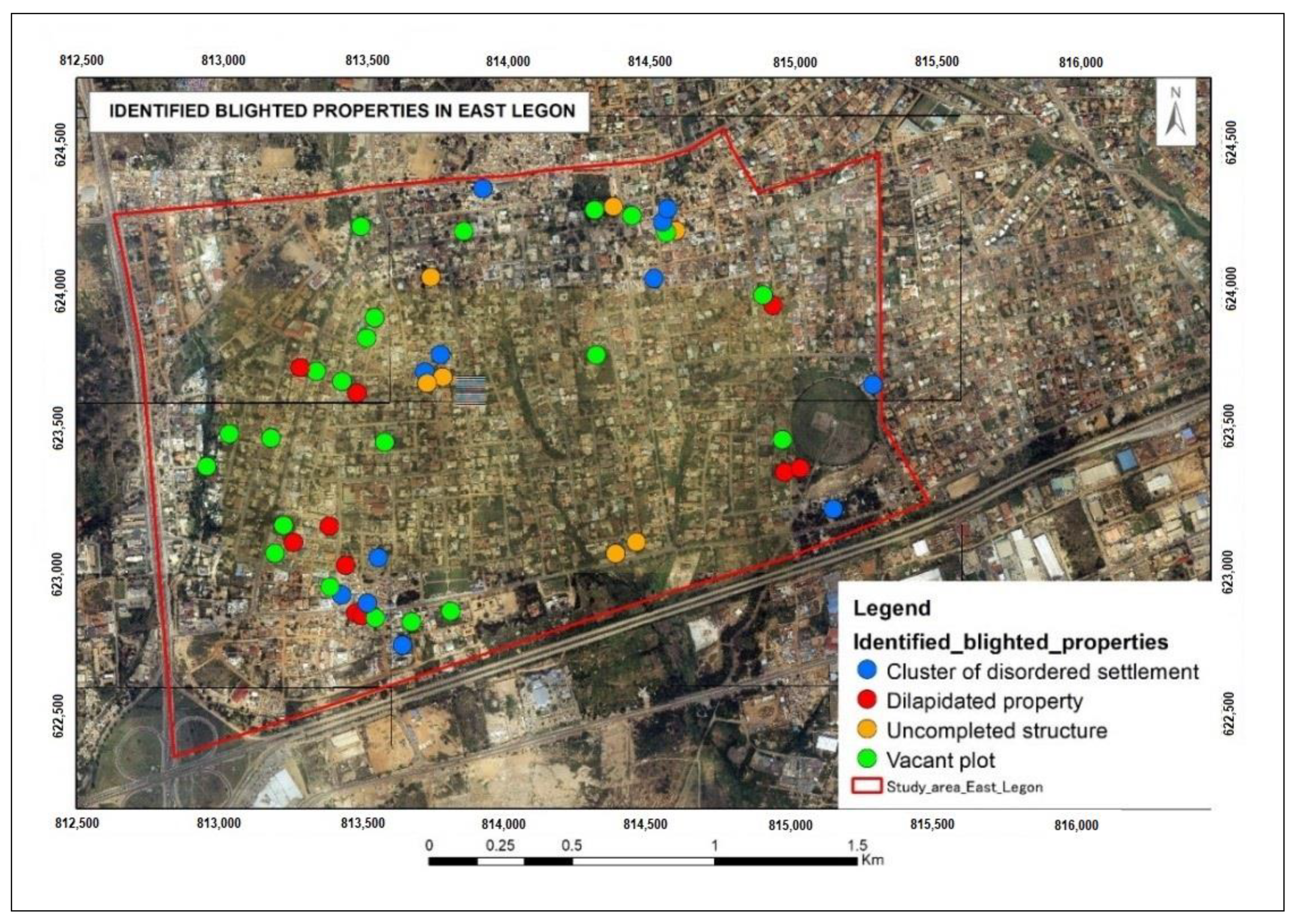
4.1. Current Distribution of Urban Blight in East Legon
4.2. Local Perception of Urban Blight
4.3. Urbanisation in East Legon
4.4. The Underlying Reasons for Urban Blight in East Legon
4.4.1. Socio-Cultural Values Attached to Real Property
4.4.2. Customary Land Control Versus Weak Enforcement of Urban Policies
4.4.3. Land Disputes
4.4.4. Hybrid Land Tenure and Administration
4.4.5. Economic Reasons
4.5. Effects of Urban Blight on Land Use and Development in the Study Area
4.5.1. Positive Effects
Establishment of Security
Companionship
4.5.2. Negative Effects
Aesthetics
Underutilisation of Properties
Social Inequality and Tension
Pollution
Insecurity
5. Discussion
5.1. Urbanisation and Distribution of Blight
5.2. Reasons for Urban Blight
5.3. Effects of Urban Blight
6. Conclusions
Author Contributions
Funding
Institutional Review Board Statement
Informed Consent Statement
Data Availability Statement
Acknowledgments
Conflicts of Interest
Appendix A. Analytical Framework
Appendix B. Photograph Used for Photo-Elicitation during Fieldwork

References
- Goldstein, J.; Jensen, M.; Reiskin, E. Urban Vacant Land Redevelopment: Challenges and Progress; South End Press: Boston, MA, USA, 2001. [Google Scholar]
- Breger, G. The Concept and Causes of Urban Blight. Land Econ. 1967, 43, 369–376. [Google Scholar] [CrossRef]
- Gordon, C. Blighting the Way: Urban Renewal, Economic Development, and the Elusive Definition of Blight. Fordham Urban Law 2004, 31, 305–337. [Google Scholar]
- Weaver, R.C. Re-framing the urban blight problem with trans-disciplinary insights from ecological economics. Ecol. Econ. 2013, 90, 168–176. [Google Scholar] [CrossRef]
- Cuthbert, A. Urban decay and regeneration: Context and issues. J. Urban Des. 2017, 22, 140–143. [Google Scholar] [CrossRef]
- Pacione, M. Urban Geography: A Global Perspective, 3rd ed.; Routledge: London, UK, 2009; Volume 53, ISBN 9788578110796. [Google Scholar]
- Chimhowu, A. The ‘new’ African customary land tenure. Characteristic, features and policy implications of a new paradigm. Land Use Policy 2019, 81, 897–903. [Google Scholar] [CrossRef]
- Abubakari, Z.; Richter, C.; Zevenbergen, J. Plural inheritance laws, practices and emergent types of property-implications for updating the land register. Sustainability 2019, 11, 17. [Google Scholar] [CrossRef] [Green Version]
- Government of Ghana. Land Use and Spatial Planning Act, 2016; Ghana Publishing Press: Accra, Ghana, 2016; pp. 1–106.
- Appiahene-Gyamfi, J. Urban crime trends and patterns in Ghana: The case of Accra. J. Crim. Justice 2003, 31, 13–23. [Google Scholar] [CrossRef]
- Mahama, C.; Antwi, A. Land and Property Markets in Ghana; RICS: London, UK; RICS: Vancouver, BC, Canada, 2006. [Google Scholar]
- Oluwagbemiga, P.A.; Mohd, H.R.; Ismail, S. Neighbourhood Open Space’s Attachment and Utilization Characteristics among Ethnic Groups in Rural Community of South-West Nigeria. In Proceedings of the International Alliance for Sustainable Urbanization and Regeneration, Chiba, Japan, 17–24 October 2014. [Google Scholar]
- Haase, A.; Bernt, M.; GroBmann, K.; Mykhnenko, V.; Rink, D. Varieties of shrinkage in European cities. Eur. Urban Reg. Stud. 2016, 23, 86–102. [Google Scholar] [CrossRef]
- Reckien, D.; Martinez-Fernandez, C. Why do cities shrink? Eur. Plan. Stud. 2011, 19, 1375–1397. [Google Scholar] [CrossRef]
- Nelle, A.; Großmann, K.; Haase, D.; Kabisch, S.; Rink, D.; Wolff, M. Urban shrinkage in Germany: An entangled web of conditions, debates and policies. Cities 2017, 69, 116–123. [Google Scholar] [CrossRef]
- Audirac, I.; Cunningham-Sabot, E.; Fol, S.; Moraes, S.T. Declining Suburbs in Europe and Latin America. Int. J. Urban Reg. Res. 2012, 36, 226–244. [Google Scholar] [CrossRef]
- Crankshaw, O.; White, C. Racial Desegregation and Inner City Decay in Johannesburg. Int. J. Urban Reg. Res. 1995, 19, 622–638. [Google Scholar] [CrossRef]
- Morris, A. The Desegregation of Hillbrow, Johannesburg, 1978–1982. Urban Stud. 1994, 31, 821–834. [Google Scholar] [CrossRef]
- Asabere, P.K. The Determinants of Land Values Values in an African City: The Case of Accra, Ghana. Land Econ. 1981, 57, 385–397. [Google Scholar] [CrossRef]
- Cobbinah, P.B.; Aboagye, H.N. A Ghanaian twist to urban sprawl. Land Use Policy 2017, 61, 231–241. [Google Scholar] [CrossRef]
- Getis, A. Analytically derived neighborhoods in a rapidly growing West African city: The case of Accra, Ghana. Habitat Int. 2015, 45, 126–134. [Google Scholar] [CrossRef] [PubMed] [Green Version]
- Cobbinah, P.B.; Erdiaw-Kwasie, M.O.; Amoateng, P. Africa’s urbanisation: Implications for sustainable development. Cities 2015, 47, 62–72. [Google Scholar] [CrossRef]
- Ross, C.E.; Mirowsky, J. Disorder and Decay: The Concept and Measurement of Perceived Neighborhood Disorder. Urban Aff. Rev. 1999, 34, 412–432. [Google Scholar] [CrossRef]
- Hosseini, A.; Pourahmad, A.; Taeeb, A.; Amini, M.; Behvandi, S. Renewal strategies and neighborhood participation on urban blight. Int. J. Sustain. Built Environ. 2017, 6, 113–121. [Google Scholar] [CrossRef]
- Haase, A.; Rink, D.; Grossmann, K.; Bernt, M.; Mykhnenko, V. Conceptualizing urban shrinkage. Environ. Plan. A 2014, 46, 1519–1534. [Google Scholar] [CrossRef] [Green Version]
- Albers, G. Urban development, maintenance and conservation: Planning in Germany—Values in transition. Plan. Perspect. 2006, 21, 45–65. [Google Scholar] [CrossRef]
- Livingston, M.; Bailey, N.; Kearns, A. Neighbourhood attachment in deprived areas: Evidence from the north of England. House Built Environ. 2010, 25, 409–427. [Google Scholar] [CrossRef]
- Cobbinah, P.B.; Erdiaw-Kwasie, M.O.; Amoateng, P. Rethinking sustainable development within the framework of poverty and urbanisation in developing countries. Environ. Dev. 2015, 13, 18–32. [Google Scholar] [CrossRef]
- Amirtahmasebi, R.; Orloff, M.; Wahba, S.; Altman, A. Regenerating Urban Land; Internation Bank for Reconstruction and Development/The Word Bank: Washington, DC, USA, 2016; ISBN 9781464804731. [Google Scholar]
- Bales, K. Determinants in the perceptions of visual blight. Hum. Ecol. 1985, 13, 371–387. [Google Scholar] [CrossRef]
- Weaver, R.C.; Bagchi-Sen, S. Spatial analysis of urban decline: The geography of blight. Appl. Geogr. 2013, 40, 61–70. [Google Scholar] [CrossRef]
- Miekley, A. Counting Broken Windows: The Pursuit of an Objective Measurement of Blight; University of Cincinnati: Cincinnati, OH, USA, 2008. [Google Scholar]
- Hoekveld, J.J. Understanding Spatial Differentiation in Urban Decline Levels. Eur. Plan. Stud. 2014, 22, 362–382. [Google Scholar] [CrossRef]
- Fabiyi, O.O. Analysis of Urban Decay from Low Resolution Satellite Remote Sensing Data: Example from Organic City in Nigeria. Int. J. Dev. Manag. Rev. 2011, 6, 172–189. [Google Scholar]
- UN-HABITAT. Sustainable Cities and Communities—SDG Goal 11, Monitoring Framework; UN-HABITAT: Nairobi, Kenya, 2016. [Google Scholar]
- De Vries, W.T.; Voß, W. Economic Versus Social Values in Land and Property Management: Two Sides of the Same Coin? Raumforsch. Raumordn. Spat. Res. Plan. 2018, 76, 381–394. [Google Scholar] [CrossRef] [Green Version]
- Galster, G. On the Nature of Neighbourhood. Urban Stud. 2001, 38, 2111–2124. [Google Scholar] [CrossRef]
- Somerville, P.; Van Beckhoven, E.; Van Kempen, R. The decline and rise of neighbourhoods: The importance of neighbourhood governance. Eur. J. Hous. Policy 2009, 9, 25–44. [Google Scholar] [CrossRef]
- Hidalgo, C.M.; Bernardo, H. Place Attachment: Conceptual and Empirical Questions. J. Environ. Psychol. 2001, 21, 273–281. [Google Scholar] [CrossRef]
- Hay, R. Sense of Place in Developmental Context. Environ. Psychol. 1998, 18, 5–29. [Google Scholar] [CrossRef]
- Livingston, M.; Bailey, N.; Kearns, A. People’s Attachment to Place—The Influence of Neighbourhood Deprivation; Joseph Rowntree Foundation: York, UK, 2008. [Google Scholar]
- Scannell, L.; Gifford, R. Defining place attachment: A tripartite organizing framework. J. Environ. Psychol. 2010, 30, 1–10. [Google Scholar] [CrossRef]
- Kleinhans, R.; Priemus, H.; Engbersen, G. Understanding Social Capital in Recently Restructured Urban Neighbourhoods: Two Case Studies in Rotterdam. Urban Stud. 2007, 44, 1069–1091. [Google Scholar] [CrossRef]
- Johnston, C. What Is Social Value; Technical publications: Canberra, Australia, 1992; Volume 3. [Google Scholar]
- Elias, T.O. The Nature of African Customary Law; Manchester United Press: Manchester, UK, 1956. [Google Scholar]
- Arko-Adjei, A. Adapting Land Administration to the Institutional Framework of Customary Tenure. Ph.D. Thesis, University of Twente, Enschede, The Netherlands, 2011. [Google Scholar]
- Ubink, J.M.; Quan, J.F. How to combine tradition and modernity? Regulating customary land management in Ghana. Land Use Policy 2008, 25, 198–213. [Google Scholar] [CrossRef]
- Mends, T. Customary Land Tenure and Urbanizarion with Case Study on the Peri-Urban Area of Accra, Ghana; International Institute for Geo-Information Science and Earth Observation: Enschede, The Netherlands, 2006. [Google Scholar]
- Kingwill, R.A. The Map Is not the Territory: Law and Custom in ‘African Freehold’: A South African Case Study. Ph.D. Thesis, University of the Western Cape, Cape Town, South Africa, 2013. [Google Scholar]
- Abubakari, Z.; Richter, C.; Zevenbergen, J. Making space legible across three normative frames: The (non-) registration of inherited land in Ghana. Geoforum 2020, 108, 217–226. [Google Scholar] [CrossRef]
- Yin, R. Getting Started: How to Know Whether and When to Use the Case Study as a Research Method. In Case Study Research Design and Methods; Knight, V., Young, J., Koscielak, K., Bauhaus, B., Dickens, G., Eds.; Sage Publications, Inc.: Thousand Oakst, CA, USA, 2014; pp. 1–25. [Google Scholar]
- Berry, S. Property, Authority and Citizenship: Land Claims, Politics and the Dynamics of Social Division in West Africa. Dev. Change 2009, 40, 23–45. [Google Scholar] [CrossRef]
- Anim-Odame, W.K.; Key, T.; Stevenson, S. Measures of real estate values from land registration and valuation systems in emerging economies: The case of Ghana. J. Real Estate Lit. 2009, 17, 63–84. [Google Scholar] [CrossRef]
- Arguello, M.E.J.; Ayele, B.M.; Blaustein, S.M. The Millennium Cities Initiative: Accra; Earth Institute: Accra, Ghana, 2015. [Google Scholar]
- Ross, L.H. Housing code enforcement and urban decline. J. Afford. Hous. Community Dev. Law 1996, 6, 29–46. [Google Scholar]
- Clarke, P.; Ailshire, J.; Melendez, R.; Bader, M.; Morenoff, J. Using Google Earth to conduct a neighbourhood audit: Reliability of a virtual audit instrument. Health Place 2010, 16, 1224–1229. [Google Scholar] [CrossRef] [Green Version]
- Pratomo, J.; Kuffer, M.; Martinez, J.; Kohli, D. Coupling uncertainties with accuracy assessment in object-based slum detections, case Study: Jakarta, Indonesia. Remote Sens. 2017, 9, 164. [Google Scholar]
- Kohli, D.; Sliuzas, R.; Stein, A. Urban slum detection using texture and spatial metrics derived from satellite imagery. J. Spat. Sci. 2016, 61, 405–426. [Google Scholar] [CrossRef] [Green Version]
- Bakx, W.; Janssen, L.; Schetselaar, E.; Tempfli, K.; Tolpekin, V.; Westinga, E. Image Analysis. In The Core of GIScience: A Process Based Approach; Tolpekin, V., Stein, A., Eds.; Faculty of Geo-Information Science and Earth Observation (ITC), University of Twente: Enschede, The Netherlands, 2013; pp. 205–225. [Google Scholar]
- Bryman, A. Social Research Methods, 4th ed.; Oxford University Press Inc.: New York, NY, USA, 2012; Volume 112. [Google Scholar]
- Kumar, R. Sampling. In Research Methodology; Sage Publications Limited: London, UK, 2005; pp. 164–184. [Google Scholar]
- Gyapong, P. Assessing Customary Land Tenure Institutions for Land Administration in Ghana: Good Governance Perspective (Case Study of Gbawe, Greater Accra, Ghana); International Institute for Geo-Information Science and Earth Observation (ITC): Enschede, The Netherlands, 2009. [Google Scholar]
- Asiama, S. Land as a source of revenue mobilisation for local authorities in Ghana. J. Sci. Technol. 2006, 26, 116–123. [Google Scholar] [CrossRef]
- Siiba, A.; Adams, E.A.; Cobbinah, P.B. Chieftaincy and sustainable urban land use planning in Yendi, Ghana: Towards congruence. Cities 2018, 73, 96–105. [Google Scholar] [CrossRef]
- Clarke, J.I. The Growth of Capital Cities in Africa. Africa Spectr. 1971, 6, 33–40. [Google Scholar]
- De Soto, H. The Mystery of Capital: Why Capitalism Triumphs in the West and Fails Everywhere Else; Black Swan, Ed.; Bantam Press: London, UK, 2000. [Google Scholar]
- Abubakari, Z.; Richter, C.; Zevenbergen, J. Exploring the “implementation gap” in land registration: How it happens that Ghana’s official registry contains mainly leaseholds. Land Use Policy 2018, 78, 539–554. [Google Scholar] [CrossRef]
- Zevenbergen, J. Systems of Land Registration. Asp. Eff. 2002, 15–199. [Google Scholar]


| The Nuances of Urban Blight | Description & Sources from Literature |
|---|---|
| An idea with regards to the use of real property | Urban blight is described as an idea in the minds of various stakeholders concerning the condition, use and function of real property [21,22]. |
| The lack of basic urban infrastructure | Urban blight is an element that is caused by a lack of infrastructure [3,22]. |
| Neighbourhood disorder/lack of physical beauty | Many abandoned and deteriorated buildings in the area [23,24,25]. |
| Results in physical stagnation | The attributes of urban blight are visually demeaning and aesthetically depressing. This could lead to stagnation of land use and development in an area [30]. |
| A contributing factor to slum | Urban blight is an element that results in a slum [3]. Additionally, Breger [2] emphasises that historically, slums were regarded as blighted areas. |
| Comparable to urban decline/shrinkage | Weaver and Bagchi-Sen [31], Miekley [32] and Hoekveld [33] believe that the leading causes of urban blight from the global north perspective, such as poverty, unemployment, and vacancy, align with urban factors for decline/shrinkage. |
| The initial stage of urban decay | The severe phase of urban blight is used to describe urban decay’s commencement [2]. Urban decay as explained by Fabiyi [34] is the neglect of the built environment symbolised by poor urban dwellers unable to repair their old structures. |
| No. | Categorised Forms of Blight | Criteria According to the Land Use and Spatial Planning Act 2016 (Act 925) |
|---|---|---|
| (a) | Cluster of disordered settlements | “Irregularity of plots or parcels” |
| “Lack of access to plots or habitable dwelling within the area” | ||
| “Safety or restriction to the other authorised users” | ||
| “Overcrowding leading to unhealthy population density” | ||
| “Lack of sanitation, drainage or appropriate service” | ||
| (b) | Vacant plot/undeveloped land | “Safety or restriction to the other authorised users” |
| “Adverse impact on the environment” | ||
| (c) | Single dilapidated (degraded) property | “Incompatibility with the existing or proposed use; the spatial development framework; and the structure or local plan” |
| “Diversity of existing use which makes development control difficult or impossible” | ||
| “Safety or restriction to the other authorised users” | ||
| “High incidence of crime which has been confirmed to be attributable to the type of development” | ||
| (d) | Uncompleted buildings | “Adverse impact on the environment” |
| “High incidence of crime which has been confirmed to be attributable to the type of development” |
| No. | Description of Respondents | Sampling Strategy | Total Number |
|---|---|---|---|
| 1 | Residents | Convenience sampling | 12 |
| 2 | Property owners | 8 | |
| 3 | Real estate developers | 2 | |
| Experts | |||
| 4 | Lands Commission | Purposive sampling | |
| i. | Public and Vested Lands Management Division | 2 | |
| ii. | Land Valuation Division | 1 | |
| iii. | Survey and Mapping Division | 1 | |
| 5 | Land Use and Spatial Planning Authority | 1 | |
| 6 | Local Government Authorities | ||
| i. | Accra Metropolitan Assembly | 1 | |
| ii. | Ayawaso West Municipal Assembly | 2 | |
| Total number | 30 |
| Local Perception | Respondents | ||||
|---|---|---|---|---|---|
| Experts | Property Owners | Residents | Real Estate Developers | ||
| 1 | Aesthetics | ✓ | |||
| 2 | Indigenous buildings—“atakpami” (local term for mud houses) | ✓ | ✓ | ||
| 3 | Squatter settlements—“kiosks” (local term for wooden structures built by illegal settlers) | ✓ | ✓ | ✓ | |
| 4 | Untapped economic potential | ✓ | |||
Publisher’s Note: MDPI stays neutral with regard to jurisdictional claims in published maps and institutional affiliations. |
© 2021 by the authors. Licensee MDPI, Basel, Switzerland. This article is an open access article distributed under the terms and conditions of the Creative Commons Attribution (CC BY) license (https://creativecommons.org/licenses/by/4.0/).
Share and Cite
Mireku, S.A.; Abubakari, Z.; Martinez, J. Dimensions of Urban Blight in Emerging Southern Cities: A Case Study of Accra-Ghana. Sustainability 2021, 13, 8399. https://doi.org/10.3390/su13158399
Mireku SA, Abubakari Z, Martinez J. Dimensions of Urban Blight in Emerging Southern Cities: A Case Study of Accra-Ghana. Sustainability. 2021; 13(15):8399. https://doi.org/10.3390/su13158399
Chicago/Turabian StyleMireku, Sally Adofowaa, Zaid Abubakari, and Javier Martinez. 2021. "Dimensions of Urban Blight in Emerging Southern Cities: A Case Study of Accra-Ghana" Sustainability 13, no. 15: 8399. https://doi.org/10.3390/su13158399
APA StyleMireku, S. A., Abubakari, Z., & Martinez, J. (2021). Dimensions of Urban Blight in Emerging Southern Cities: A Case Study of Accra-Ghana. Sustainability, 13(15), 8399. https://doi.org/10.3390/su13158399