
Saline Soils: A Potentially Significant Geoheritage of the Vojvodina Region, Northern Serbia

 ,
,  , and
, and 
Abstract
:1. Introduction
2. The Main Characteristics of Saline Soils in Vojvodina
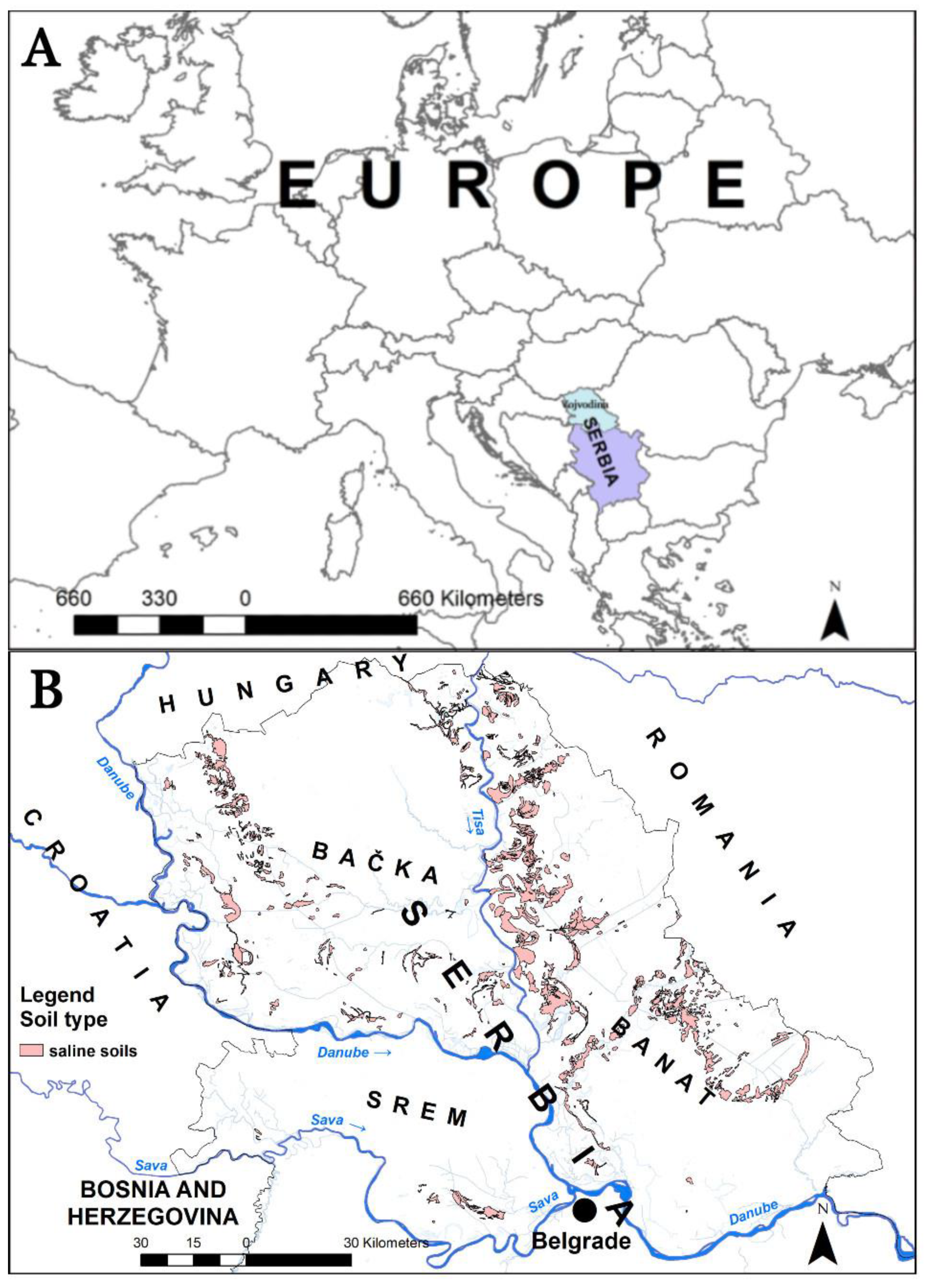
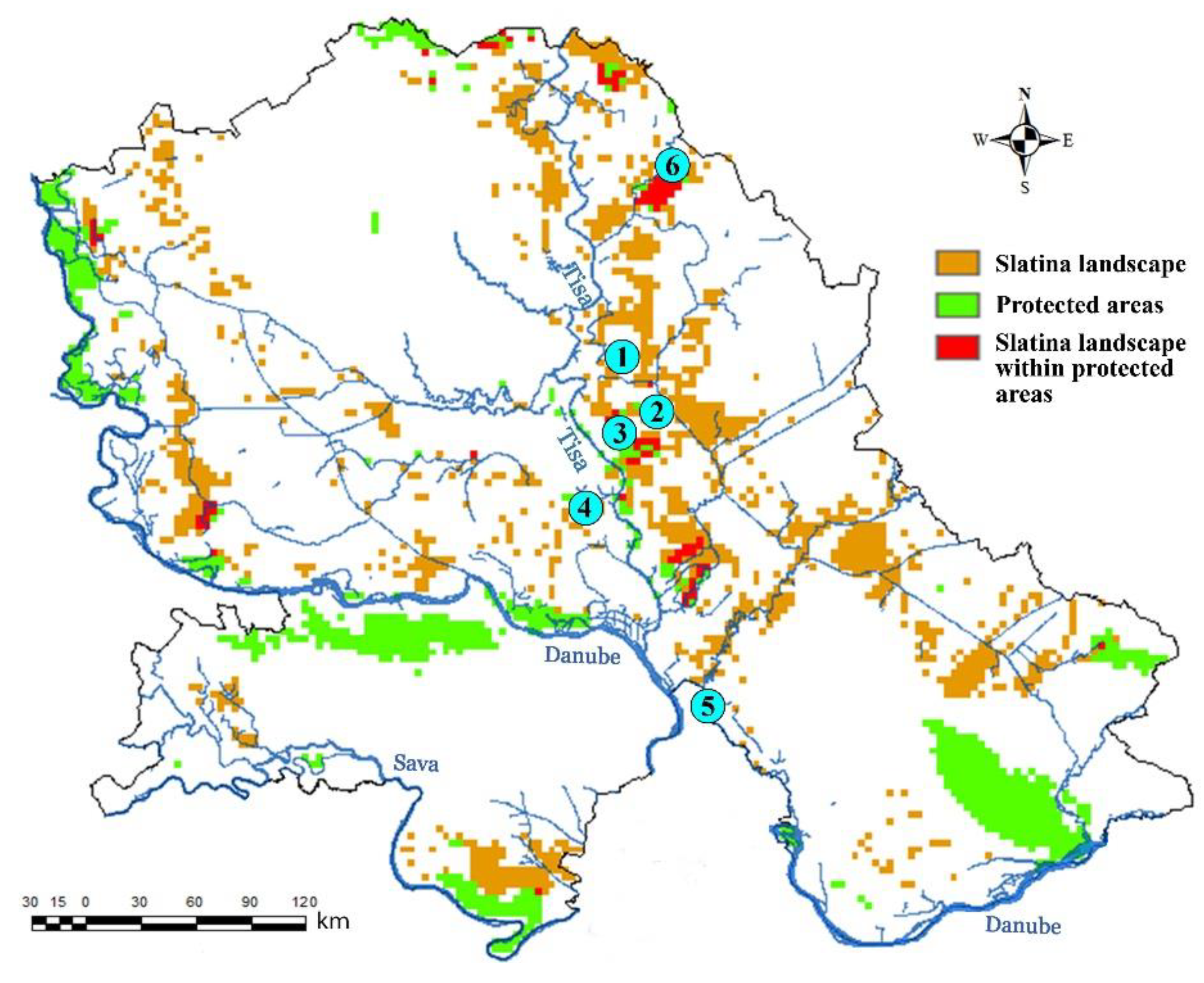
3. Study Area
4. Methodology
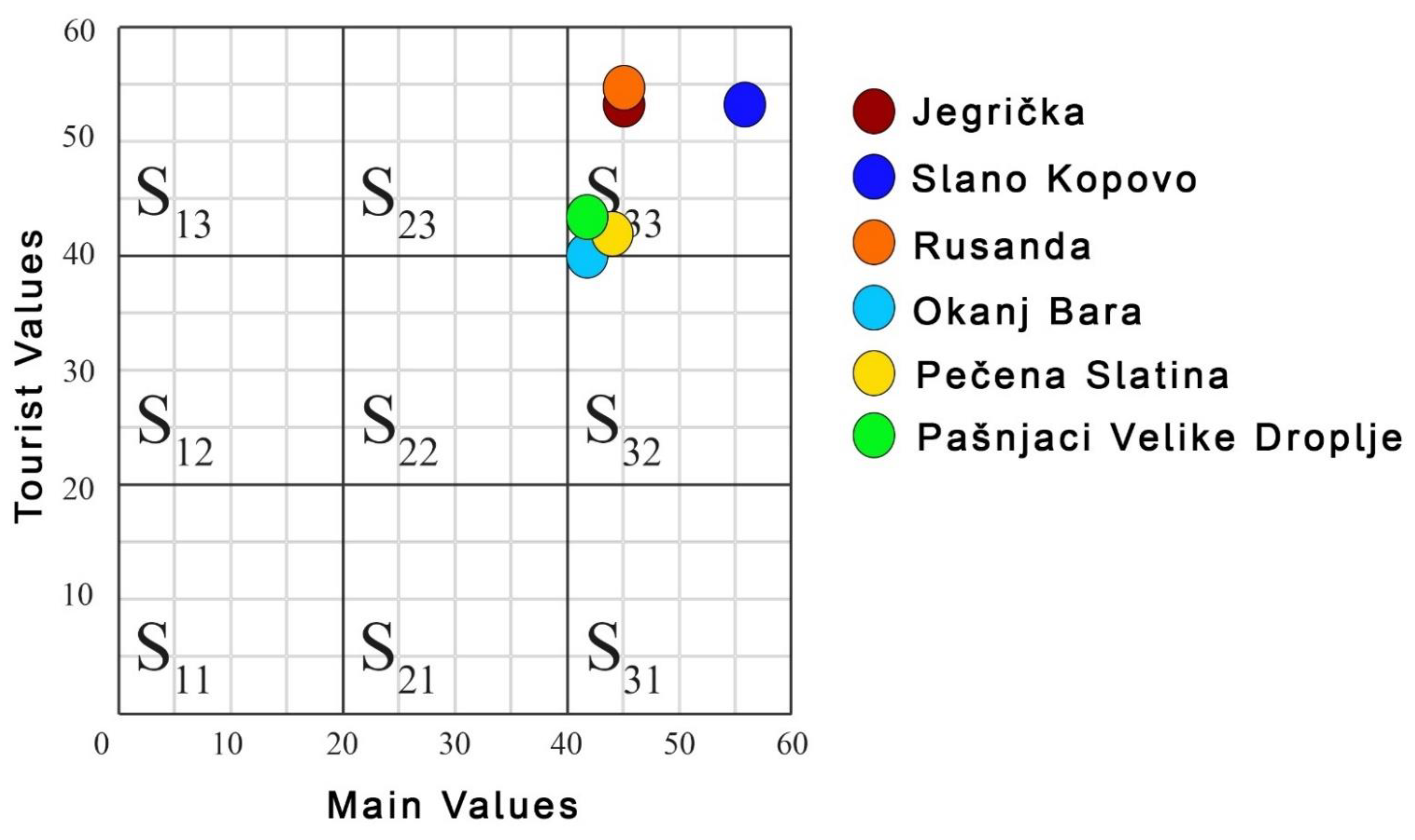
5. Results and Disscussion
6. Conclusions
Author Contributions
Funding
Institutional Review Board Statement
Informed Consent Statement
Data Availability Statement
Conflicts of Interest
References
- Directorate–General for Research and Innovation (European Commission). Proposed Mission: Caring for Soil Is Caring for Life. Available online: https://op.europa.eu/en/publication-detail/-/publication/4ebd2586-fc85-11ea-b44f-01aa75ed71a1/ (accessed on 21 April 2021).
- FAO. World Reference Base for Soil Resources 2014, Update 2015. Available online: http://www.fao.org/soils-portal/data-hub/soil-classification/world-reference-base/en/ (accessed on 21 April 2021).
- Bach, E.; Ramirez, K.; Fraser, T.; Wall, D. Soil biodiversity Integrates Solutions for a Sustainable Future. Sustainability 2020, 12, 2662. [Google Scholar] [CrossRef] [Green Version]
- Conway, J.S. A Soil Trail?–A Case Study from Anglesey, Wales, UK. Geoheritage 2010, 2, 15–24. [Google Scholar] [CrossRef]
- De Almeda Rengel, L.; do Carmo Oliviera Jorge, M.; Guerra, A.J.T.; Fullen, M.A. Geotourism and Soil Quality on Trails Within Conservation Units in South-East Brazil. Geoheritage 2019, 11, 1151–1161. [Google Scholar] [CrossRef]
- Qadir, M.; Ghafoor, A.; Murtaza, G. Amelioration strategies for saline soils: A review. Land Degrad. Develop. 2000, 11, 501–521. [Google Scholar] [CrossRef]
- Rengasamy, P. World salinization with emphasis on Australia. J. Exp. Bot. 2006, 57, 1017–1023. [Google Scholar] [CrossRef] [Green Version]
- Miller, J.J.; Brierley, J.A. Solonetzic soils of Canada: Genesis, distribution, and classification. Can. J. Soil Sci. 2011, 91, 889–902. [Google Scholar] [CrossRef]
- Food and Agriculture Organization of the United Nations (2016) Saline Soils and Their Management. 2016. Available online: http://www.fao.org/3/x5871e/x5871e04.htm (accessed on 22 April 2021).
- Gupta, R.K.; Abrol, I.P. Salt-Affected Soils: Their Reclamation and Management for Crop Production. Adv. Soil Sci. 1990, 11, 223–289. [Google Scholar]
- Statistical Year book 2020, Statistical Office of the Republic of Serbia. Available online: https://www.stat.gov.rs/sr-cyrl/publikacije/publication/?p=12694 (accessed on 23 April 2021).
- Miljković, N.; Eberhard, L.D.; Ayers, D.A. Salt-affected Soils of Yugoslavia. Soil Sci. 1959, 88, 51–55. [Google Scholar] [CrossRef]
- Miljković, N. Osnovi Pedologije; Univerzitet u Novom Sadu: Novi Sad, Serbia, 1996. [Google Scholar]
- Petrović, M. Alkalične Bare u Okolini Sombora; Letopis Matice Srpske: Novi Sad, Serbia, 1882. [Google Scholar]
- De Sigmond, A. The alkali soils in Hungary and their reclamation. Soil Sci. 1924, 18, 379–381. [Google Scholar] [CrossRef]
- Sigmond, A. Report on the Genetica of Alkali Soils. Translation of the Alkali subcom Of the International Society of Soil Science; International Society of Soil Science: Budapest, Hungary, 1929; Volume A. [Google Scholar]
- De Sigmond, A. Development of Soil Science. Soil Sci. 1935, 40, 77–87. [Google Scholar] [CrossRef]
- Treitz, P. A Szikes Talajok Javitása, Budapest; Stádium Sajtóvállalat Részvénytársaság: Budapest, Hungary, 1924. [Google Scholar]
- Treitz, P. The “szik” lands in the Great-Central-Plain of Hungary. In Proceedings of the Papers I-st International Congress of Soil Science, Washington, DC, USA, 13–22 June 1927; Volume V. [Google Scholar]
- Treitz, P. Hidrológiai Kőzlemények; Hydrological Sect. of the Hungarian Geological Society: Budapest, Hungary, 1931. [Google Scholar]
- Miljković, N. Iskorišćavanje i Popravljanje Slatina; Zadružna Knjiga: Beograd, Serbia, 1955. [Google Scholar]
- Živković, B. Gipsovanje Sodnih Slatina u Vojvodini; Arhiv za Poljoprivredne Nauke: Belgrade, Serbia, 1954; p. 16. [Google Scholar]
- Jovica, V. Solonchaks of Vojvodina-characteristics and contemporaryClassification. Ph.D. Thesis, University of Novi Sad, Faculty of Agriculture, Novi Sad, Serbia, 2009, unpublished work. [Google Scholar]
- Daliakopoulos, I.N.; Tsanis, I.K.; Koutroulis, A.; Kourgialas, N.N.; Varouchakis, A.E.; Karatzas, G.P.; Ritsema, C.J. The threat of soil salinity: A European scale review. Sci. Total Environ. 2016, 573, 727–739. [Google Scholar] [CrossRef]
- Škorić, A.; Filipovski, G.; Čirić, M. Klasifikacija Zemljišta Jugoslavije, Akademija Nauka i Umjetnisti Bosne i Hercegovine, Posebna izdanja, Knjiga LXXVII, Sarajevo; Akademija Nauka i Umjetnosti Bosne i Hercegovine: Sarajevo, Bosnia and Herzegovina, 1985. [Google Scholar]
- Panjković, B.; Perić, R.; Stojšić, V. Okanj bara-important center of floristic and ecosystem diversity of the Tisa river basin (Serbia). Studia Univ. Vasile Goldiş Arad Ser. Ştiinţele Viętii 2011, 21, 767–772. [Google Scholar]
- Popov, D.; Marković, S.B.; Štrbac, D. Generations of meanders in Serbian part of Tisa valley. Zb. Rad. Geogr. Inst. Jovan Cvijić SANU 2008, 58, 31–42. [Google Scholar] [CrossRef]
- Vandenberghe, J.; Kasse, C.K.; Popov, D.; Markovic, S.B.; Vandenberghe, D.; Bohncke, S.; Gabris, G. Specifying the external impact on fluvial lowland evolution: The last glacial Tisza (Tisa) catchment in Hungary and Serbia. Quaternary 2018, 1, 14. [Google Scholar] [CrossRef] [Green Version]
- Marković, S.; Kicošev, S.; Lazić, L. Relief of Tamiš river vally (Banat, Yugoslavia). Geogr. Timisiensis 1995, 4, 19–27. [Google Scholar]
- Marković, S.; Lukač, Š.; Kicošev, S. Slano Kopovo. Zaštita Prir. 1995, 48–49, 321–326. [Google Scholar]
- Savić, R.; Ondrasek, G.; Zemunac, R.; Kovacčić, M.B.; Kranjcec, F.; Jokanović, V.N.; Bezdan, A. Longitudinal distribution of macronutrients in the sediments of Jegricka watercourse in Vojvodina, Serbia. Sci. Total Environ. 2021, 754, 142138. [Google Scholar] [CrossRef]
- Vidaković, D.; Krizmanić, J.; Dojčinović, B.P.; Pantelić, A.; Gavrilović, B.; Živanović, M.; Novaković, B.; Ćirić, M. Alkaline soda Lake Velika Rusanda (Serbia): The first insight into diatom diversity of this extreme saline lake. Extremophiles 2019, 23, 347–357. [Google Scholar] [CrossRef]
- Tomić, N.; Stojsavljević, R.; Stamenković, I.; Berić, D. The use of geothermal energy resources in the tourism industry of Vojvodina (Northern Serbia). Eur. Res. 2013, 2–3, 443–454. [Google Scholar]
- Fužinato, S.; Fodora, A.; Subakov-Simić, G. Arthrospira fusiformis (Voronichin) Komarel et lund (Cyanoprokaryota)—A new species for Europe. Algol. Stud. 2010, 134, 17–24. [Google Scholar] [CrossRef]
- Stojnić, N.; Puzović, S.; Habijan-Mikeš, V. Present status, threatening factors and conservation measures of great bustard (Otis tarda) in Serbia. Zaštita Prir. 2009, 60, 285–294. [Google Scholar]
- Sipos, G.; Kiss, T. Szigetképződés és Fejlődés a Maros Határszakaszán (Island formation and development on the border section of River Maros). Vízügyi Közlemények 2003, 85, 225–238. [Google Scholar]
- Pašić, M.; Dolinaj, D.; Stojanović, V. The importance of preservation of autochthonous biotope of Panonian Plane in the area of special nature reserve’Pašnjaci velike droplje’for education and ecotourism development. Turizam 2008, 12, 23–29. [Google Scholar] [CrossRef]
- Pralong, J.P. A method for assessing tourist potential and use of geomorphological sites. Géomorphologie 2005, 11, 189–196. [Google Scholar] [CrossRef]
- Serrano, E.; González-Trueba, J.J. Assessment of geomorphosites in natural protected areas: The Picos de Europa National Park (Spain). Géomorphol. Formes Process Environ. 2005, 3, 197–208. [Google Scholar] [CrossRef] [Green Version]
- Reynard, E.; Fontana, G.; Kozlik, L.; Scapozza, C. A method for assessing “scientific” and “additional values” of geomorphosites. Geogr. Helv. 2007, 62, 148–158. [Google Scholar] [CrossRef]
- Tomić, N. The potential of Lazar Canyon (Serbia) as a geotourism destination: Inventory and evaluation. Geogr. Pannonica 2011, 15, 103–112. [Google Scholar] [CrossRef]
- Tomić, N.; Božić, S. A modified geosite assessment model (M-GAM) and its application on the Lazar Canyon area (Serbia). Int. J. Environ. Res. 2014, 8, 1041–1052. [Google Scholar]
- Tomić, N.; Košić, K. Developing the Spa Assessment Model (SAM) and its application on the Kopaonik-Jastrebac Spa Zone (Serbia). Tour. Manag. Perspect. 2020, 36, 100753. [Google Scholar] [CrossRef]
- du Cros, H. A new model to assist in planning for sustainable cultural heritage tourism. Int. J. Tour. Res. 2001, 3, 165–170. [Google Scholar] [CrossRef]
- Laing, J.; Wheeler, F.; Reeves, K.; Frost, W. Assessing the experiential value of heritage assets: A case study of a Chinese heritage precinct, Bendigo, Australia. Tour. Manag. 2014, 40, 180–192. [Google Scholar] [CrossRef]
- McKercher, R.; Ho, P. Assessing the tourism potential of smaller cultural and heritage attractions. J. Sustain. Tour. 2006, 14, 473–488. [Google Scholar] [CrossRef]
- Božić, S.; Tomić, N. Developing the Cultural Route Evaluation Model (CREM) and its application on the Trail of Roman Emperors, Serbia. Tour. Manag. Perspect. 2016, 17, 26–35. [Google Scholar] [CrossRef]
- Antić, A.; Tomić, N.; Đorđević, T.; Marković, S.B. Promoting Palaeontological Heritage of Mammoths in Serbia Through a Cross-Country Thematic Route. Geoheritage 2021, 13, 7. [Google Scholar] [CrossRef]
- Antić, A.; Tomić, N. Assessing the speleotourism potential together with archaeological and palaeontological heritage in Risovača Cave (Central Serbia). Acta Geoturistica 2019, 10, 1–11. [Google Scholar]
- Antić, A.; Tomić, N.; Marković, S.B. Karst geoheritage and geotourism potential in the Pek River lower basin (eastern Serbia). Geogr. Pannoni. 2019, 23, 32–46. [Google Scholar] [CrossRef]
- Boškov, J.; Kotrla, S.; Jovanović, M.; Tomić, N.; Lukić, T.; Rvović, I. Application of the Preliminary Geosite Assessment Model (GAM): The case of the Bela Crkva Municipality (Vojvodina, North Serbia). Geogr. Panonica 2015, 19, 146–152. [Google Scholar] [CrossRef]
- Božić, S.; Tomić, N. Canyons and gorges as potential geotourism destinations in Serbia: Comparative analysis from two perspectives–general geotourists’ and pure geotourists’. Open Geosci. 2015, 7, 531–546. [Google Scholar] [CrossRef] [Green Version]
- Božić, S.; Tomić, N.; Pavić, D. Canyons as potential geotourism attractions of Serbia–comparative analysis of Lazar and Uvac canyons by using M-GAM model. Acta Geoturistica 2014, 5, 18–30. [Google Scholar]
- Gelvez-Chaparro, J.; Barajas-Rangel, D.; Herrera-Ruiz, J.; Rios-Reyes, C.A. Introducción al Geopatrimonio kárstico del municipio de El Peñón (Santander), Colombia. Boletín Geol. 2020, 42, 147–167. [Google Scholar] [CrossRef]
- Jonić, V. Comparative analysis of Devil’s town and Bryce canyon geosites by applying the modified geosite assessment model (M-GAM). Res. Rev. Dep. Geogr. Tour. Hotel Manag. 2018, 47, 113–125. [Google Scholar] [CrossRef]
- Pál, M.; Albert, G. Comparison of geotourism assessment models: And experiment in Bakony–Balaton UNSECO Global Geopark, Hungary. Acta Geoturistica 2018, 9, 1–13. [Google Scholar] [CrossRef] [Green Version]
- Tomić, N.; Marković, S.B.; Korać, M.; Mrđić, N.; Hose, T.A.; Vasiljević, D.J.A.; Jovičić, M.; Gavrilov, M.B. Exposing mammoths-from loess research discovery to public palaeontological park. Quat. Int. 2015, 372, 142–150. [Google Scholar] [CrossRef]
- Tomić, N.; Antić, A.; Marković, S.B.; Đorđević, T.; Zorn, M.; Valjavec, M.B. Exploring the potential for speleotourism development in eastern Serbia. Geoheritage 2019, 11, 359–369. [Google Scholar] [CrossRef]
- Tomić, N.; Marković, S.B.; Antić, A.; Tešić, D. Exploring the potential for geotourism development in the Danube region of Serbia. Int. J. Geoheritage Parks 2020, 8, 123–139. [Google Scholar] [CrossRef]
- Tičar, J.; Tomić, N.; Valjavec, M.B.; Zorn, M.; Marković, S.B.; Gavrilov, M.B. Speleotourism in Slovenia: Balancing between mass tourism and geoheritage protection. Open Geosci. 2018, 10, 344–357. [Google Scholar] [CrossRef]
- Vukoičić, D.; Milosavljević, S.; Valjarević, A.; Nikolić, M.; Srećković-Batoćanin, D. The evaluation of geosites in the territory of National park Kopaonik“ (Serbia). Open Geosci. 2018, 10, 618–633. [Google Scholar] [CrossRef]
- Vuković, S.; Antić, A. Speleological approach for geotourism development in Zlatibor county (west Serbia). Turizam 2019, 23, 53–68. [Google Scholar] [CrossRef] [Green Version]
- Antić, A.; Tomić, N.; Đorđević, T.; Radulović, M.; Đević, I. Speleological objects becoming show caves: Evidence from the Valjevo karst area in Western Serbia. Geoheritage 2020, 12, 1–12. [Google Scholar] [CrossRef]
- Antić, A.; Tomić, N.; Marković, S.B. Karst-based geotourism in Eastern Carpathian Serbia: Exploration and evaluation of natural stone bridges. Geoconservation Res. 2020, 3, 62–80. [Google Scholar]
- Bratić, M.; Marjanović, M.; Radivojević, A.R.; Pavlović, M. M-GAM method in function of tourism potential assessment: Case study of the Sokobanja basin in eastern Serbia. Open Geosci. 2020, 12, 1468–1485. [Google Scholar] [CrossRef]
- Tomić, N.; Sepehriannasab, B.; Marković, S.B.; Hao, Q.; Lobo, H.A.S. Exploring the Preferences of Iranian Geotourists: Case Study of Shadows Canyon and Canyon of Jinns. Sustainability 2021, 13, 798. [Google Scholar] [CrossRef]
- Pál, M.; Albert, G. Examining the Spatial Variability of Geosite Assessment and Its Relevance in Geosite Management. Geoheritage 2021, 13. [Google Scholar] [CrossRef]
- Milenković, J. Evaluation of Geo-sites in the Podrinje-Valjevo Mountains with Respect to Geo-tourism Development. Geoheritage 2021, 13, 44. [Google Scholar] [CrossRef]
- Lee, C.-F.; King, B.E. Using the Delphi method to assess the potential of Taiwan’s hot springs tourism sector. Int. J. Tour. Res. 2008, 10, 341–352. [Google Scholar] [CrossRef] [Green Version]
- Yu-Qi, L.; De-You, M.; Jing-Hong, S. Assessing development potential of hot spring tourism resources in Hunan province. Resour. Environ. Yangtze Basin 2012, 6, 692–699. [Google Scholar]
- Xian, W.; Zha, L. Quantitative assessment and development strategy for hot springs tourism destination in Wan-Jiang urban belt. Resour. Environ. Yangtze Basin 2012, 11, 1323–1329. [Google Scholar]
- Lazić, L.; Pavić, D.; Stojanović, V.; Tomić, P.; Romelić, J.; Pivac, T.; Košić (Pavlica), K.; Besermenji, S.; Kicošev, S.; Đermati, Z.; et al. Protected Natural Assets and Ecotourism in Vojvodina; Faculty of Sciences, Department of Geography, Tourism and Hotel Management: Novi Sad, Serbia; University of Novi Sad: Novi Sad, Serbia, 2008. [Google Scholar]
- Puzović, S.; Panjković, B.; Tucakov, M.; Stojnić, N.; Sabadoš, K.; Stojanović, T.; Vig, L.; Marić, B.; Tešić, O.; Kiš, A.; et al. Upravljanje Prirodnom Baštinom u Vojvodini (Natural Heritage Management in Vojvodina); Pokrajinski Sekretarijat za Urbanizam: Novi Sad, Serbia, 2015. [Google Scholar]


| Soil Type | Main Characteristics |
|---|---|
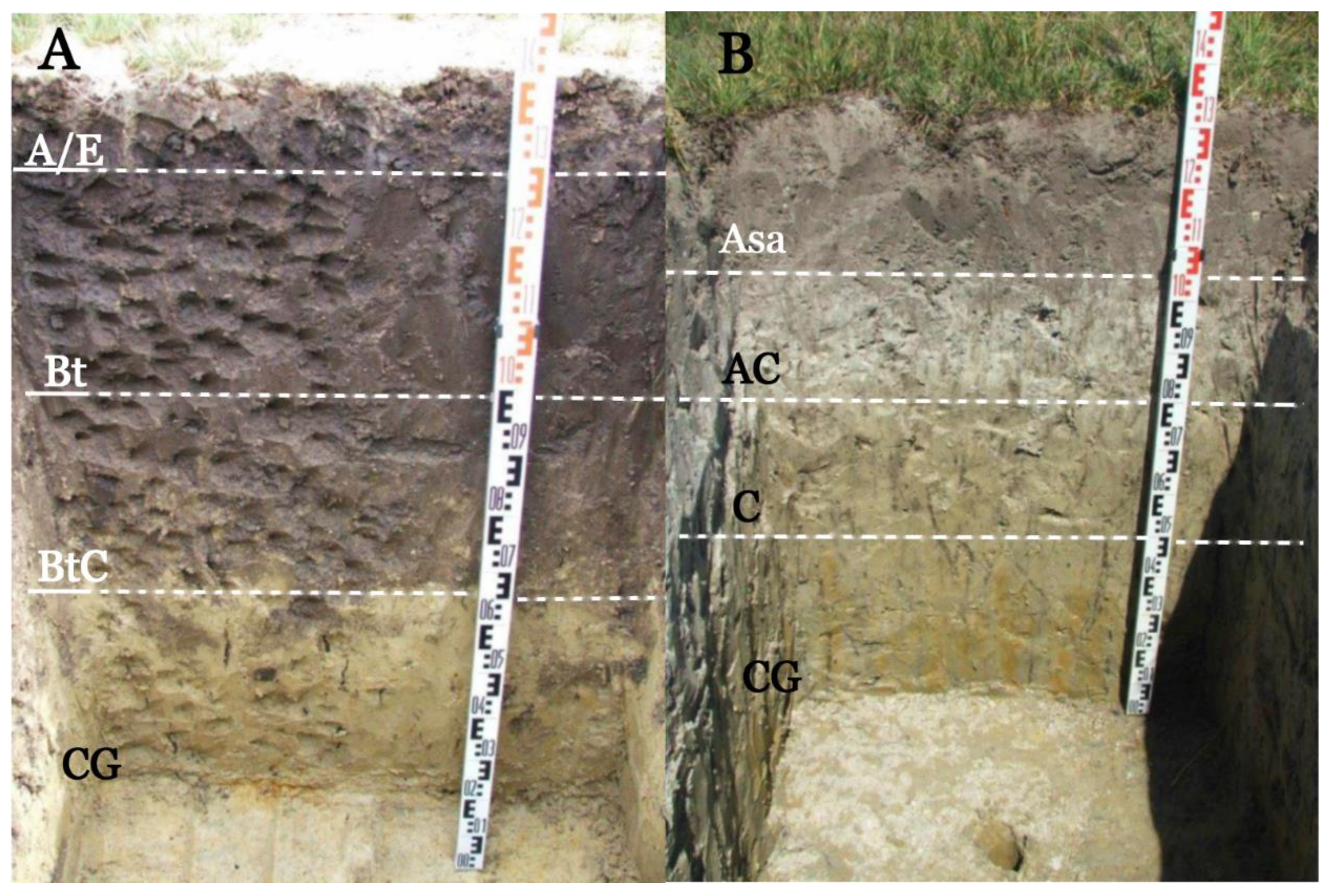
| Solonetz | Salt content usually ranging 0.15–0.25% in Bt horizon. Characterized by relatively shallow surface A/E horizon and a thick Bt horizon with over 15% of adsorbed sodium ions (Na+). The surface A/E horizon has a weakly acidic pH reaction, as a result of leaching of carbonates and water-soluble salts. Occupy the surface of 75,000 ha in the Vojvodina Region. |
| Solonchak | Containing at least 1% of salt (chloride and sulfate salinization) or more than 0.7% (sodic salinization), in any horizon up to 125 cm of depth. The internal morphology is often structured as Asa/E-Bt-BtC and as Asa-AC-C. High alkaline pH values of soil in all horizons due to the intensive alkalinization process. Characterized by extremely low microbiological activity and the low number of individual groups of microorganisms in the surface saline layer. Occupy the surface of 15,000–25,000 ha in the Vojvodina Region. |
| Indicators/Subindicators | Description | ||||
|---|---|---|---|---|---|
| Main values (MV) | |||||
| Number of sites nearby with similar overall characteristics | ||||
| Level of interpretive possibilities on pedological processes and pedogenesis | ||||
| Number of existing micro-landforms (meanders, point bars, old river valleys, etc.) | ||||
| Number of different soil types and varieties | ||||
| Number of different vascular plant and bird species (must inhabit the site for at least a part of the year) | ||||
| Total number of endemic and relict plant species as well as those included in the world red list of threatened species and the red list of Serbian flora. | ||||
| The character of the site as it relates to its visual experience for potential visitors—contrast of colors, appearance of shapes, etc. | ||||
| Panoramic view quality, presence of water and vegetation, absence of human-induced deterioration, vicinity of urban areas, etc. | ||||
| Therapeutical value of the soil (related to perceived utility as a treatment of medical conditions and how often it is used for such purposes). | ||||
| Protected status by local or regional groups, national government, international organizations, etc. | ||||
| Vulnerability level of soils (their risks from natural processes and anthropogenic influences) | ||||
| Proposed number of visitors that can sustainably utilize the site at the same time, based onsurface area, vulnerability, and the current state of the site | ||||
| Tourist values (TV) | |||||
| Ease with which the site can be reached | ||||
| Number of additional natural values (within a radius of 5 km) | ||||
| Number of additional anthropogenic values (within a radius of 5 km) | ||||
| Level and number of promotional resources | ||||
| Annual number of organized visits to the site | ||||
| Closeness of visitor center to the site | ||||
| Interpretative characteristics and value of text and graphics, material quality, planel size, suitability to surroundings, etc. | ||||
| Annual number of visitors | ||||
| Level of additional infrastructure for tourists such as pedestrian pathways, resting places, garbage cans, toilets etc. | ||||
| If local expertise exists, the level, knowledge of foreign language(s), interpretative skills, etc. of the experts | ||||
| Hostelry services close to the site | ||||
| Restaurant services close to the site | ||||
| Grades (1–5) | |||||
| 1 | 2 | 3 | 4 | 5 | |
| 1. | Common | Regional | National | International | The only occurrence |
| 2. | None | Moderate level of processes, difficult to explain to non-experts | Good example of processes but difficult to explain to non-experts | Moderate level of processes but easy to explain to a common visitor | Good example of processes and easy to explain to a common visitor |
| 3. | 1 | - | 2–3 | - | More than 3 |
| 4. | 1–2 types/varieties | 3–4 types/varieties | 5–6 types/varieties | 7–8 types/varieties | More than 8 |
| 5. | Up to 100 species | 101–150 species | 151–200 species | 201–300 species | More than 300 species |
| 6. | 1 or 2 species | 3–4 species | 5–6 species | 7–8 species | More than 8 species |
| 7. | - | Low | Medium | High | Exceptional |
| 8. | - | Low | Medium | High | Exceptional |
| 9. | Not used for treatment | Occasionally used for treatment by the locals | Often used for treatment by the locals | Intensively used for treatment by the locals | Organized treatment in the form of a spa |
| 10. | None | Local | Regional | National | International |
| 11. | Irreversible (with possibility of total loss) | High (could be easily damaged) | Medium (could be damaged by natural processes or human activities) | Low (could be damaged only by human activities) | None |
| 12. | 0 | 0 to 10 | 10 to 20 | 20 to 50 | More than 50 |
| 13. | Inaccessible | Low (on foot with special equipment and expert guide tours) | Medium (by bicycle and other means of man-powered transport) | High (by car) | Utmost (by bus) |
| 14. | None | 1 | 2 to 3 | 4 to 6 | More than 6 |
| 15. | None | 1 | 2 to 3 | 4 to 6 | More than 6 |
| 16. | None | Local | Regional | National | International |
| 17. | None | Less than 10 per year | 11–12 per year | 13–14 per year | More than 14 per year |
| 18. | More than 50 km | 50 to 20 km | 20 to 5 km | 5 to 1 km | Less than 1 km |
| 19. | None | Low quality | Medium quality | High quality | Utmost quality |
| 20. | None | Low (less than 100) | Medium (101 to 150) | High (151 to 200) | Utmost (more than 200) |
| 21. | None | Low | Medium | High | Utmost |
| 22. | None | Low | Medium | High | Utmost |
| 23. | More than 50 km | 25–50 km | 10–25 km | 5–10 km | Less than 5 km |
| 24. | More than 25 km | 10–25 km | 10–5 km | 1–5 km | Less than 1 km |
| Values Given by Experts (1–5) | ||||||
|---|---|---|---|---|---|---|
| Main Values (MV) | SS1 | SS2 | SS3 | SS4 | SS5 | SS6 |
| Jegrička | Slano Kopovo | Rusanda | Okanj Bara | Pečena Slatina | Pašnjaci Velike droplje | |
| 1. Rarity | 3 | 5 | 4 | 3 | 4 | 3 |
| 2. Possibilities for interpretation and education | 4 | 5 | 4 | 3 | 4 | 2 |
| 3. Geomorphological attractiveness | 4 | 5 | 4 | 3 | 4 | 3 |
| 4. Pedodiversity | 3 | 5 | 3 | 2 | 5 | 5 |
| 5. Biodiversity | 4 | 5 | 3 | 4 | 3 | 4 |
| 6. Endemic and relict plant and animal species | 4 | 5 | 3 | 3 | 2 | 2 |
| 7. Ambience | 4 | 5 | 4 | 4 | 4 | 4 |
| 8. Surrounding landscape and nature | 5 | 4 | 3 | 4 | 3 | 3 |
| 9. Therapeutical value | 2 | 3 | 5 | 3 | 4 | 2 |
| 10. Protection level | 4 | 5 | 4 | 4 | 3 | 4 |
| 11. Vulnerability | 3 | 4 | 3 | 4 | 3 | 5 |
| 12. Suitable number of visitors | 5 | 5 | 5 | 5 | 5 | 5 |
| Sum of Main Values | 45 | 56 | 45 | 42 | 44 | 42 |
| Tourist Values (TV) | ||||||
| 13. Accessibility | 5 | 4 | 4 | 3 | 4 | 3 |
| 14. Additional natural values | 5 | 5 | 5 | 5 | 5 | 5 |
| 15. Additional anthropogenic values | 5 | 5 | 5 | 5 | 5 | 5 |
| 16. Promotion | 2 | 5 | 3 | 2 | 2 | 3 |
| 17. Organized visits | 5 | 5 | 5 | 4 | 4 | 3 |
| 18. Vicinity of visitor’s centers | 5 | 5 | 3 | 3 | 2 | 5 |
| 19. Interpretative panels | 3 | 5 | 5 | 5 | 3 | 4 |
| 20. Number of visitors | 5 | 5 | 5 | 4 | 4 | 4 |
| 21. Tourism infrastructure | 4 | 4 | 5 | 3 | 3 | 3 |
| 22. Tour guide service | 4 | 4 | 4 | 2 | 2 | 2 |
| 23. Hostelry service | 5 | 3 | 5 | 2 | 4 | 3 |
| 24. Restaurant service | 5 | 3 | 5 | 2 | 4 | 3 |
| Sum of Tourist Values | 53 | 53 | 54 | 40 | 42 | 43 |
Publisher’s Note: MDPI stays neutral with regard to jurisdictional claims in published maps and institutional affiliations. |
© 2021 by the authors. Licensee MDPI, Basel, Switzerland. This article is an open access article distributed under the terms and conditions of the Creative Commons Attribution (CC BY) license (https://creativecommons.org/licenses/by/4.0/).
Share and Cite
Zeremski, T.; Tomić, N.; Milić, S.; Vasin, J.; Schaetzl, R.J.; Milić, D.; Gavrilov, M.B.; Živanov, M.; Ninkov, J.; Marković, S.B. Saline Soils: A Potentially Significant Geoheritage of the Vojvodina Region, Northern Serbia. Sustainability 2021, 13, 7891. https://doi.org/10.3390/su13147891
Zeremski T, Tomić N, Milić S, Vasin J, Schaetzl RJ, Milić D, Gavrilov MB, Živanov M, Ninkov J, Marković SB. Saline Soils: A Potentially Significant Geoheritage of the Vojvodina Region, Northern Serbia. Sustainability. 2021; 13(14):7891. https://doi.org/10.3390/su13147891
Chicago/Turabian StyleZeremski, Tijana, Nemanja Tomić, Stanko Milić, Jovica Vasin, Randall J. Schaetzl, Dubravka Milić, Milivoj B. Gavrilov, Milorad Živanov, Jordana Ninkov, and Slobodan B. Marković. 2021. "Saline Soils: A Potentially Significant Geoheritage of the Vojvodina Region, Northern Serbia" Sustainability 13, no. 14: 7891. https://doi.org/10.3390/su13147891
APA StyleZeremski, T., Tomić, N., Milić, S., Vasin, J., Schaetzl, R. J., Milić, D., Gavrilov, M. B., Živanov, M., Ninkov, J., & Marković, S. B. (2021). Saline Soils: A Potentially Significant Geoheritage of the Vojvodina Region, Northern Serbia. Sustainability, 13(14), 7891. https://doi.org/10.3390/su13147891