Article

Understanding People−Forest Relationships: A Key Requirement for Appropriate Forest Governance in South Sumatra, Indonesia

1
College of Economics and Management, Northeast Forestry University, Harbin 150040, China
2
Forestry Program Study, Muhammadiyah University of Palembang, Palembang 30263, Indonesia
3
Forestry Department, Muhammadiyah University of West Sumatra, Padang 25172, Indonesia
4
Human Resources Education and Training Center for Environment and Forestry, Bogor 16118, Indonesia
5
School of Environmental Science and Engineering, Shanghai Jiao Tong University, Shanghai 200240, China
6
College of Wildlife and Protected Area, Northeast Forestry University, Harbin 150040, China
*
Authors to whom correspondence should be addressed.
Sustainability 2021, 13(13), 7029; https://doi.org/10.3390/su13137029
Submission received: 9 April 2021 / Revised: 7 June 2021 / Accepted: 18 June 2021 / Published: 23 June 2021
(This article belongs to the Special Issue Social Ecology, Climate Resilience and Sustainability in the Tropics)

Abstract

:
Indonesian forestry challenges in attributional land-use conflicts of overlapping villages and state forests have affected community livelihoods and forest sustainability for decades. This empirical research uncovers the socio-economic attributes of villages in order to gain a better understanding of people−forest relationships in order to guide improved forest management and governance for long-term sustainability. Data were obtained from 69 villages located in the forest management unit of Lakitan Bukit Cogong in South Sumatra Province. Spatially-explicit quantitative measurements and qualitative approaches were employed to explore the interrelationships between human footprint, village development, and conflict resolution strategies over two decades. The results confirmed that utilization of forest areas as part of the village territory (such as for building settlements, public/social infrastructure facilities, plantations and agricultural fields) has long been administered without permits, destabilizing forest functions. Moreover, aspects such as human population size, proximity of villages to the national road and sub-district capital, and the transmigration settlement units have an impact on the Human Footprint Index and Village Development Index. Furthermore, our analyses identified three distinctive forms of conflict based on village type: (1) villages which are administratively included in the forest area; (2) villages for transmigration settlement; and (3) villages adjacent to company management concession areas. In these villages, the clarity of land/forest boundaries and property rights are predominant conflict issues. Several recommendations are proposed to support sustainable forest development; namely, controlling human activities in the forest, improving village management governance, and resolving associated conflicts.

1. Introduction

The unauthorized and illegal use of forest land by humans has become a global problem, especially in Indonesia [1,2]. Improper resolution and poor governance ordinarily results in land conflicts [3], threatening the value of forest areas and community livelihoods [4]. Additionally, unlicensed conversion of forest areas for agricultural activities is a recognized consequence of escalating economic needs, driven by rising populations [5,6,7,8,9]. While some of this conversion arises from the deliberate expansion of migrant communities [10,11], some is also attributed to hereditarily existing customary claims [12]. Therefore, many countries have started to change their mindset and acknowledge the existence of communities in forest areas [13]. In recent decades, studies and policy models have been adopted which focus on the empowerment of forest peoples [14,15,16,17,18,19,20].
In Indonesia, some ambitious policies and programs by the national government have been implemented, namely the Agrarian Reform (Tanah Obyek Reforma Agraria, or TORA) and the Social Forestry (SF) program [21,22,23] to promote win–win solutions among actors with land interests [23,24]. These policies and programs did not only provide legal social access to the land but also improved the quality of life by promoting forest-based community management practices [24,25]. However, implementing and achieving these policies and targets is relatively difficult and intricate [24,26,27]. Besides, tenure conflicts are frequently occurring on the land, to the extent that this has been identified as the primary reason for the failure in forest governance [28].
Based on existing regulations, the whole zonation of Indonesian state forest lands are administratively divided into the village boundaries. It is important to note that the village is still the primary socio-economic entity in rural Indonesia. Thus, to represent the socio-economics of society, this research will use the village as a unit of analysis. The profound understanding of peoples engaged in forest activities, as well as village development and characteristics, is necessary [29,30,31] in the consideration of appropriate landscape management implementation [32,33,34]. In order to achieve the objectives of TORA and SF policies, it is essential to examine the socio-economic characteristics of communities in state forest regions as an initial step in assessing goals and prominent program choices.
Based on Indonesia government regulations No. 12/2019 about Financial Regional Management [35], Forest Management Units (FMUs) are the lowest forest management entities in Indonesia [36] which can operate effectively as a public service agency (known as BLU-Badan Layanan Umum). For an institution that holds BLU status, FMU will fulfil its position as the institution responsible for managing businesses and generating income (independent financial management) in community-based forest business units. By analyzing at the FMU scale, the findings of this study will hence promote financial support in the forest and community development as well as provide basic data for assessment and mapping/clustering of program implementation monitoring and evaluation. The usability and applicability of the results of this study are further enhanced by spatial depiction and representation.
This study aims to answer three principal questions. Firstly, what are the types of human activity and their respective impacts on forest biophysics, including evidence of humans in forest history? Secondly, what are the conditions of socio-economic growth of the village? Lastly, how can the conflicts among actors around the forest landscape be described and what are their approaches towards resolution? We use three forms of analysis to answer these issues, including human footprint (HF), village development (VD), and conflicts analysis. To the best of our knowledge, the empirical research presented here is the first to analyze villages’ socio-economic conditions by three different approaches and datasets consisting of human footprint index (HFI), Village Development Index (VDI), and conflict mapping and resolution strategies.

2. Materials and Methods
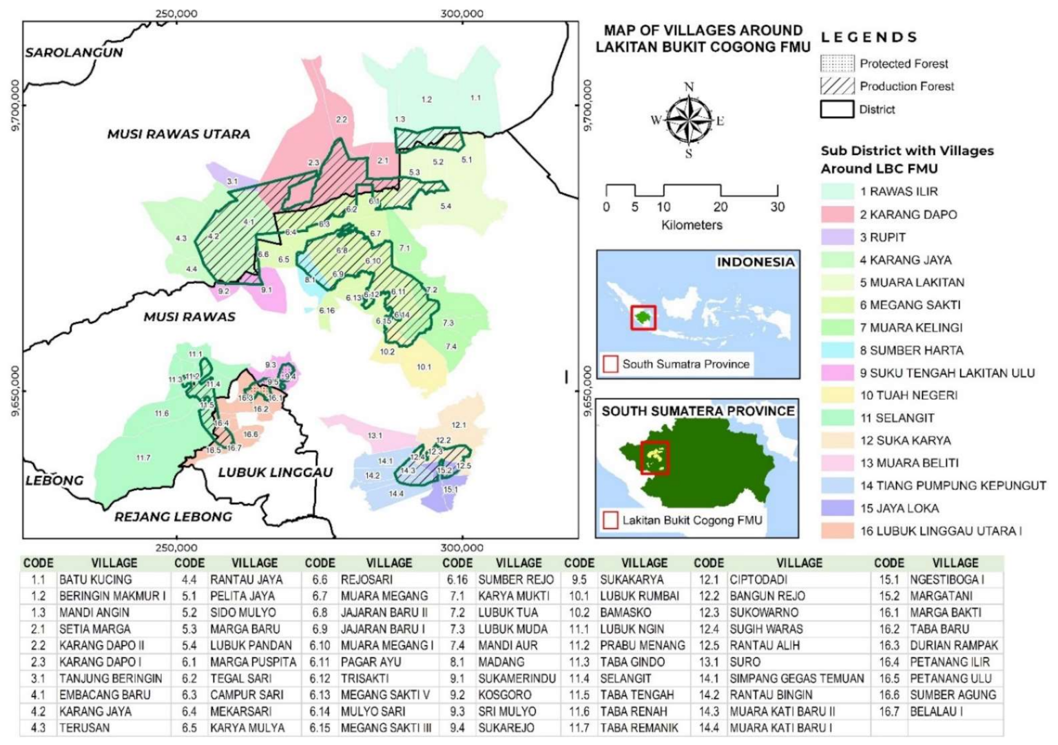
2.1. Study Area

This research was conducted in the Production FMU of Lakitan-Bukit Cogong (LBC), South Sumatra Province, Indonesia, 102°46′12″ to 103°15′36″ E and 02°45′00″ to 03°16′48″ S (Figure 1). LBC is one of the Production FMU models that has been designated by the Minister of Forestry Regulation (SK.790/Menhut-II/2009) and South Sumatra Governor Regulation No. 41/2017 about the Establishment of Technical Implementation Unit (Unit Pelaksana Teknis-UPT) as an FMU in the South Sumatra Forestry Region. Based on South Sumatra Governor Regulation No. 41/2017, the LBC management area coverage is 100,960 ha [37]. However, after the spatial analysis was conducted, we concluded that there were only 71,665.71 ha as it seems five polygons have been counted twice.
As the first step, we determined the village’s name and code number (a simple identifier grouped by district/sub-district) of those inside the forest area. The term inside (known as “around”) the forest area is the village/sub-district whose territory is located in the middle or surrounded by state forests [38]. In this analysis, we used ArcGIS to overlay a map of the outer boundaries of the LBC management area with the village administrative boundary map. Following this, the names of the villages were confirmed from the village and LBC Head in accordance with the respective location of the created map.
Based on the results of forest area maps and analysis of village administrative boundaries, the LBC forest area covers three districts including Musi Rawas, Musi Rawas Utara and Lubuk Linggau. Administratively, the area of LBC covers 16 sub-districts and 69 villages (Figure 1). There were 63 villages in the production forest area and six villages in the protected forest area.

2.2. Human Footprint (HF) Analysis

Human footprint analysis is an effective method for identifying, understanding and evaluating spatial patterns of the Earth’s surface that have been transformed and influenced by anthropogenic activity [39]. Moreover, this analysis is required to support the analysis of socio-economic and biophysical factor relationships [33,40], which will ultimately influence and support more equitable land use policies between conservation and production [41]. HF analysis by Venter and colleagues [42] stemmed from the work of Sanderson and colleagues that were derived from wilderness mapping; values are expressed as percentages [43] and primary data in the form of human footprint values were provided by Venter and colleagues [44].
We use human footprint index (HFI) datasets for our research areas extracted from global terrestrial data in 1993 and 2009 with a resolution of 1 km2 pixel size. In this data, HFI was calculated by analyzing eight indicators of human activity, including (1) built-up areas, (2) population density, (3) electrical facility, (4) croplands, (5) pasture land, (6) roads, (7) railways, and (8) navigable waterways. Each human activity was weighted according to its potential impact on biodiversity. Specifically, a cumulative score between 0 and 50 was assigned to each pixel, with a value of zero reflecting no impact of human disturbance [44,45].
The analysis was conducted in the 69 village areas (inside and outside the forest territory). To build the matched dataset, first we used ArcMap 10.5 to generate the boundary shape and centroid point of the villages as the units of analysis. The 2017 spatial data obtained from the Indonesian MOEF (Ministry of Environment and Forestry) was used to determine the location, such as the LBC forest area boundary map, village boundary maps, road maps, and river maps. At each point (village centroid), we recorded (1) the human footprint in 1993 and 2009, (2) the elevation and slope, and (3) whether the point was inside or outside the forest area. Next, by utilizing the data obtained, we used the non-parametric Wilcoxon approach to evaluate differences in the expansion of human footprint, both inside and outside forest areas.

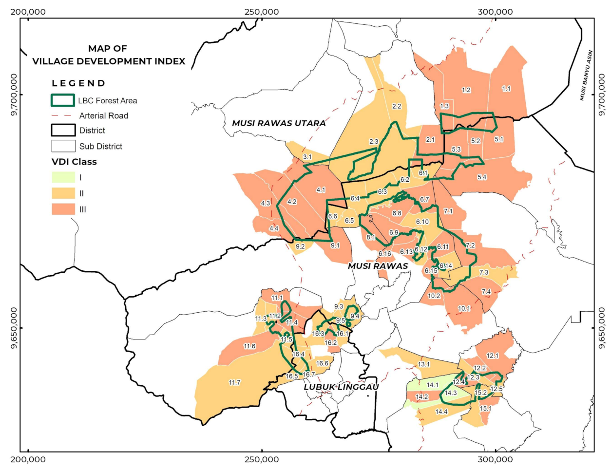
2.3. Village Development (VD) Analysis

Village development analysis is employed to analyze the VDI, which is required to represent the respective village development and autonomy (self-government) status [30]. This status enables stakeholders (especially the government and the village community itself) to empower village communities skillfully in order to achieve the village’s development goals. Thus, we selected the villages in the forest area as our unit of analysis.
We also used Village Potential Datasets (known as Potensi Desa-Podes) issued by the Bureau of Statistics (BPS) of South Sumatra Province. These datasets have been used in many regional socio-economic development assessments in Indonesia [46,47,48] to evaluate progress of programs or policy implementation such as forest management certification [49], REDD+ (Reducing emissions from deforestation and forest degradation in developing countries) [50] and community forestry [51]. Podes is publicly available as village-level socio-economic datasets that are collected three times during every 10-year period [38]. Podes datasets were collected for this study from a census of the lowest governmental administrative tier, i.e., Village, Nagari (indigenous-based governance system), and Transmigration Settlement Unit, carried out through direct interviews by trained personnel (BPS Subdistrict staff) with relevant respondents (i.e., the village leader in rural and urban areas). Thus, we used the latest available Podes datasets (2018) as development indicators in this research, which is expected to reflect the current conditions through quantitative data. Finally, 131 indicators were selected, embedded in 14 index variables (Table 1). Further details on indicators and justification are provided in Table S1 of the Supplementary Materials.
VDI was analyzed by using a scalogram technique to determine village classes through sorting and ranking the villages [52]. In this procedure, the names of village, population, and number of service facilities, along with development indicators (Table 1) were recorded in a matrix format on MS Excel and calculated on the basis of Equation (1) [52].
VD j = i n I ij I ij = I ij I i   min SD i
where VDj = regional development index; Iij = development indicators score of i in region j; I’ij = development indicators score of i in standardized regional j; Ii min = minimum regional development score; SDi = standard deviation of regional development score.
The results of the scalogram technique in this study applied the class terms and were divided into three classes. Firstly, Class 1: VDI value is greater than the sum of the average values with the standard deviation. Secondly, Class 2: VDI value is greater or equal to the average value and smaller or equal to the sum of the average values with the standard deviation. Lastly, Class 3: VDI is smaller than the average value. Accordingly, we used stepwise regression analysis to elucidate the relationship between VDI value as the dependent variable and the value of variables (Table 1) as the independent variables. Additionally, the village class was provided in spatial form and checked by both the LBC manager and the village office staff to ensure results were consistent and matched detailed knowledge of the village environment.

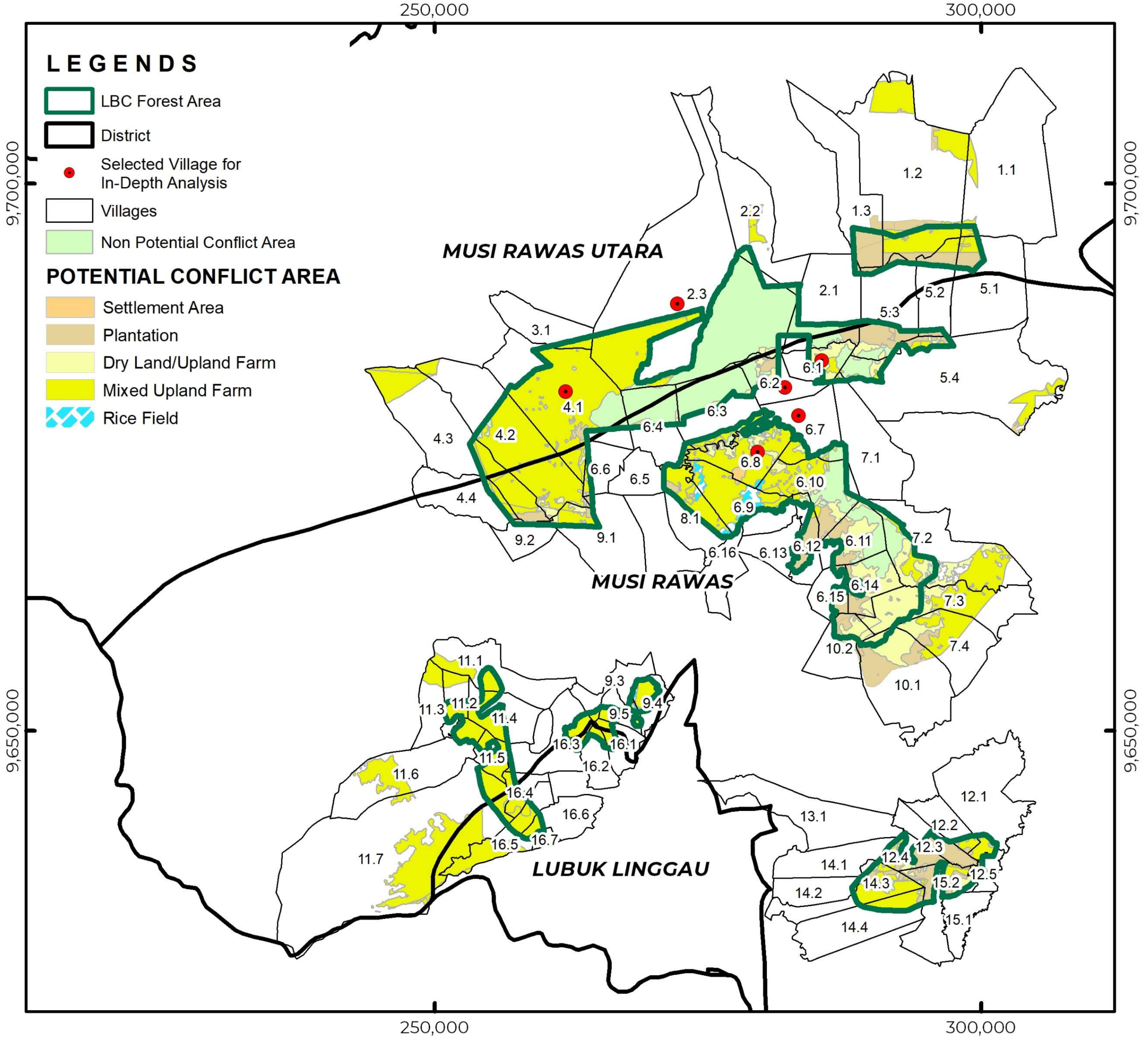
2.4. Land Conflict Analysis

We applied conflict resolution analysis to gain in-depth understanding of the social conditions in the study area. The “land-use/tenure conflict” applies to a situation involving land-use actors with conflicting interests at a geographical location that may result in adverse impacts [53]. As suggested by Gamin [52], this research is relevant in developing equitable land management measures in the forest area. This study varies from previous research because we aim to spatially identify potential disputes, categorize conflicting parties and objects, and evaluate the conflict resolution approaches on the ground.
Conflict analyses were organized as follows. In the first step, the spatial analysis was conducted to produce a map of potential conflicts. This analysis is rarely arranged in conflict resolution research, despite it being of great importance prior to field investigation [54] to help in formulating specific land use planning [55]. The map was produced by overlaying the LBC management area map, village administration map, forest management permit map, and the 2017-based land cover map. These maps were obtained from LBC and the Directorate of Inventory and Strengthening of Forest Resources (Direktorat Inventarisasi dan Pemantapan Sumber Daya Hutan-IPSDH), MOEF. Following this, potential land conflicts were generated from unpermitted forest used (resulting from its land cover) which are not appropriate with their functions and utilization. Subsequently, the map was confirmed with the corresponding authorities (LBC and village government).
The second step, namely in-depth analysis of the village conflict, was conducted from November to December 2018. This case study approach provides supporting evidence to complement spatial analysis. The site was selected purposively in reference to interviews with the head of LBC who understood the research location according to conflict vulnerability and LBC’s conflict resolution plan. In reference to these specific conditions, six villages were thereby selected as the focus of analysis, including Margapuspita, Tegal Sari, Jajaran Baru 2, Muara Megang, Embacang Baru Ilir and Karang Dapo.
After these two steps were completed, the locations of the selected villages were analyzed with qualitative analysis in the form of conflict resolution. Specifically, we used the mediation method initiated by Diaulhaq and colleagues [56,57,58]. It consists of data preparation, conflict analysis, and clarification. Face-to-face interviews were arranged with all parties, consisting of head of LBC, subdistrict head, village head, land owners and company manager(s). Conflict analysis includes reviewing several critical data/information, including conflict issues, forms, types of conflicts, objects of conflict, stakeholders/parties, and their positions and interests. The triangulation source confirmation method was used to clarify the data based on focused discussion with residents and stakeholders. Eventually, the formulation of a conflict resolution strategy and implementation strategy was administered through several workshops and focus group discussions.

3. Results and Discussion

3.1. Land Utilization by Human Activities

HFI analysis was carried out on 69 villages at two time points 16 years apart (1993 and 2009). The utilization of forest areas as villages in the form of settlements, public and social facilities, and plantation land has long been practiced. Based on the Wilcoxon test (Supplementary Material, Table S2), the average human footprint in LBC areas was increasing. The p-value (2-tailed) was 0.001, which indicates that there was a statistical difference in the human footprint within the village in the LBC area; HFI comparisons in every village are provided in Table 2. The results revealed that the HFI in the village was influenced by population growth. HFI values are affected by the existence of village transmigration management as well as proximity to the national road. Additionally, results confirmed that the area of village land inside the forest area does not affect the level of human footprint. This is because forest development and management are still under control, ensuring that HFI changes in villages where the majority of the village area is covered by forest do not result in a significant increase in HFI value. This was also relayed by Mammides, who stated that village socio-economic conditions are not always associated with protected areas [59]. HFI will be impacted specifically if the region experiences population growth and uncontrollable community forest management activities.
The highest HFI values in 2009 were found in Bangun Rejo, Ciptodadi, and Rantau Alih (all in the sub-district of Sukakarya) and Marga Bakti (Lubuk Linggau Utara 1-LLU 1). These regions are the settlement centers dominated by non-farm-based economic activities. Previous studies in this area of research [28,57] have reported that the existence of settlements and population growth are becoming influential factors for the existence of facilities and human activity on the land. LLU 1 is part of Lubuk Linggau City, in which community activities are primarily involved in processing and service businesses, as well as the urban settlements. The HFI for LLU 1 is also strongly influenced by the situation of Lubuk Linggau City’s economic activities, infrastructure, and connectivity. Meanwhile, Sukakarya is the settlement unit area of transmigration. Transmigration policies were acting as a catalyst for rapidly expanding rural industries such as oil palm and rubber plantations [60,61]. Several companies were operating in this location, namely PT Perkebunan Hasil Musi Lestari (PHML, palm oil company), PT Pertamina EP Asset 2 (oil and gas company), and local mining companies. The presence of these corporations has stimulated alterations in land use trends, infrastructure development facilities, and settlements.
From the historical perspective, these settlements were formed in connection with the existence of several activities. For example, the existence of migrant post concessions for logging in the 1970s and transmigration projects around the mid-1980s [60]. These could support the HFI data, which indicates human presence and activities in this site for at least two decades. Migrants came from areas within South Sumatra Province, initially as workers at logging companies as well as illegal loggers. After completing their works, the land was bought as a temporary settlement, still in the form of forest land.
Beyond these more historical activities, these people also expanded their land and converted it into plantations [62] that are parallel to the planting culture in Sumatra [60] and market/demand [63]. As a result, the temporary settlement gradually changed, becoming permanent. Initially, under those circumstances, the land was cleared with a burning system and planted with horticultural crops mixed with planting crops (dominated with the para rubber tree-Hevea brasiliensis). Different perennial crops were also found in other regions like coffee, cocoa, and palm [63]. Eventually, the most striking observation to emerge was that after the rubber was grown under canopy cover, it then surfaced as monoculture rubber plantations.
The above practices are similar to the re-distribution of the population under the transmigration program, although slightly different in the process of land acquisition. Trans migrants came from Java Island, which officially participated in the government’s transmigration program. In the literature review, this program is regarded as one of the drivers of deforestation [6]. Twenty-one provinces in Indonesia have been designated as destinations for transmigration. Between 1969 and 1997, a total of 264,081 families (1,139,549 people) migrated to the province of South Sumatra and notably became the destination with the highest level of immigration [64]. Each household received 0.5 ha of land for permanent settlement and home garden, as well as 2 ha of land (lahan usaha, LU) for crops cultivation (farm income). Recently, several new utilization schemes have emerged, such as oil palm planted by the contract system with companies [64]. With these capitals, most transmigrants have reached a standard of living above the poverty line [65]. At present, migration and resettlement of the population are no longer occurring. Community development can be achieved through an emphasis on improving existing land (intensification). Despite this land-use intensification, we expect that HFI values will not increase or decrease (such as in relation to consequences for the forest), although this still needs further additional research in the future, to ensure that this intensification does not lead to increasing the HFI value.
It is apparent that the highest value of HFI change (inside forest area) is for villages in Tiang Pumpung Kepungut (TPK) sub-district. This particular sub-district is one of South Sumatra’s sub-districts with significant population growth over the past few years. Therefore, the area has been divided into new villages. The state forest area is only about 0–2% (25–1500 ha) in these village areas. This finding confirms that the community began to expand throughout this period (1993 to 2009), using forest land for massive cultivation, which is why the value of “HFI Change (inside the forest area)” in Table 2 is quite substantial.
The average HFI of villages in protected forest areas in 2009 was 16.9, categorized as very high. Some protected areas had HFI values around 2–3 [66]. However, the value of “HFI change” is very low, between –0.48 and 0.5. This confirms that the exploitation was widespread prior to 1993 and virtually unchanged between 1993 and 2009. We considered it started when human beings attempted to enter this area from the 1960s–1980s by a migrant community from outside of Musi Rawas Regency. This community traditionally settled and gardened in the form of crop production, such as coffee and cloves. This situation likely substantiates the fact that anthropogenic impacts in the form of settlement, infrastructure, and land utilization affect the value of the HFI as there is evidence that there had been massive forest fires in 1993 and 1997 that mostly decimated land, trees and shrubs, and it seems likely that farmers started cultivating rubber plants after fires until the present day [65,67,68]. Currently, these burnt areas are covered by mixed para rubber vegetation of >20 years, 10–20 years, and <5 years. Moreover, further supporting evidence is the availability of MPTS (Multi Purposes Tree Species) dominated by Durio zibetinus, Ficus variegate, Pterospermum javanicum dan Spondias sp. This protected area also functions as the center of springs, not only for vegetation. The community uses water for daily needs and irrigation of land and rice fields. Despite that, land tenure claims have ended since the establishment of protected forest boundaries in 1998, followed by the Land and Forest Rehabilitation Movement (Gerakan Rehabilitasi Hutan dan Lahan) program by the Ministry of Forestry (MoF) in 2004. These findings provide confirmatory evidence that efforts to stabilize the forest area and control human activities are identified as having a positive impact on the low value of “HFI change”. While there is as yet no standardized classification of ‘high’, ‘moderate’ or ‘low’ level HFI (including changes over time), considering that the index is a 50-point scale and the range of HFI change we found across the 6 villages fell between −0.48 and 0.5 over a 16-year period, we consider the changes to be largely negligible, which may enable us to assume that any forest protection measures implemented have been successful in preventing further change.

3.2. Social-Economic Development of the Village

The spatial distribution of the village classes (Figure 2) and their analyses (Table 2) reveal that there are two villages in class I (6%), 32 villages in class II (46%), and 35 villages in class III (51%). We address several important key variables, including land use, number of farmers groups, the existence of primary facilities (education and health), and related infrastructure (road conditions, electricity availability, and communication network quality). People’s livelihoods emerge mostly from the agricultural sector in the form of irrigated and non-irrigated rice fields, as well as dryland agriculture and plantations, in particular oil palm plantations and rubber plantations. Moreover, each village has its basic education facilities (elementary schools) and a place for learning the Quran, powered by electricity, and reached by telephone signals, and women’s, youth, and farmer organizations have been formed. In contrast, some villages are not traversed by public transport, unreached by internet signals from any telecommunication providers, and are relatively distanced from universities or higher education institutions.
Statistical results (Supplementary Material, Table S3) indicate that the number of people in the population is the main factor influencing VDI. The total population in these 69 villages was 162,036 people. The villages of Marga Baru, Lubuk Tua, and Lubuk Rumbai have the highest population (more than 5000 people per village), each categorized as Class III. It is interesting to note that VDI decreases by 0.18 for every 125 people increase in the population. These factors revealed the relatively strong correlation between the village’s carrying capacity and the number of facilities, as well as the village governments’ ability to conduct good governance.
Another striking observation from the VDI spatial analysis shows that the distance from the capital of the sub-district and national roads, as well as the status of the transmigration village, are factors which influence VDI.
The villages which are sub-district capital or close to the capital/prospective capital of a sub-district influenced the VDI value. Primary facilities such as education (junior and senior high schools) and community health centers (local and small-sized hospitals), as well as economic support facilities, such as commercial banks, ATMs, markets, post offices, and expedition services (shipment), were found in these villages. The capital of the sub-district had the most straightforward and most strategic access to surrounding villages [69]. There is ample support for these conditions, such as the governance systems that exist in Indonesia and a regional development strategy, which accelerate the economic hub development and regional growth.
The availability of access roads (especially the existing National/Arterial Road, Central Sumatra highway) drives high human activity and size of settlements. Because of that, supporting facilities such as electricity, local roads, and land management were higher in these areas. Villages near arterial roads have become the location of several health facilities (clinic, pharmacy, or drugstore) and economic facilities (supermarkets, hotels, and restaurants). In addition, the road also supports business mobility in the village because it can be accessed by large-capacity vehicles. The development and existence of roads provide positive benefits for forest production with convenient access to forest resources [70,71]. Conversely, regardless of the advantage they offer, roads could increase the vulnerability of ecologically prioritized surroundings, i.e., forests with protected and conservation status [72]. The existence of roads develops and facilitates transport access to protected resources, thus jeopardizing the security of these forest resources [73,74].
Transmigration Settlement Units (TSUs) are potential locations, preferably in villages, that have been appointed as transmigration settlements by governments to support its regional growth development. They consist of approximately 300 to 500 households and have vital infrastructure facilities, general public utilities, and related supporting facility [75]. It is important to highlight the fact that a good arrangement and governance of TSUs has influenced the high value of VDI in these villages. Each TSU provided primary public facilities, namely basic education (for elementary school and Islamic learning and Quran recitation center), health centers, marketplaces, extensions centers, and social facilities in the form of religious activities. These facilities are usually superior to those in the villages in surrounding areas (i.e., excluding transmigration villages) [76]. In addition, during recent years, these physical infrastructures have been upgraded, particularly roads, which are vitally important to development and facility access. The results confirm that there is an apparent disparity in quality (road surface) infrastructure between the TSU and nearby rural areas.
We speculate the development of the villages in our study site will be difficult to increase, evident from the factors supporting their development found in this research. There appears to be a case of construction unavailability for new roads across the province and the transmigration program has been terminated. Nonetheless, we can aspire to the existence of a Village Fund program (dana desa) under the Law Number 6/2014 on Villages [77,78], which may improve the aspects of local governance strengthening [79]. Additionally, it is notable that villages and communities can utilize the Village Fund to undertake activities that provide households with direct socio-economic benefits, develop infrastructure facilities and accessibility to meet their own needs.

3.3. Social Problem in Land Utilization Activity

Based on the map of potential conflicts surrounding the LBC forest area resulting from spatial analysis (Figure 3), there are 54,744.17 ha (75% of land in the LBC forest area) that have the potential to be in conflict, and they are spread across 68 of 69 villages. The one village which was identified as being without conflict (13.1 Suro) has an outer boundary adjacent to the forest regions, but the village administrative region is not included in forest areas, likely explaining this phenomenon. Presently, these potential conflict lands are managed as settlement (1%), rice field (1%), upland farm (11%), plantation (rubber and palm oil, 13%), and mixed upland farm (50%). These results show that forest land management activities are no longer suitable for their functions. In practice, settlement and non-forest land-use activities were surprisingly built inside the forest, even in forests with “protected” status. Furthermore, there is no legally appropriate land management permit available to the villager. This condition is contrary to Indonesian Forestry Law 41/1999 [80] which states that forest area can only be used for tree cultivation or an agroforestry system can be applied which pairs forestry and agricultural crop production. Nevertheless, agroforestry system practice is not being fully implemented, and the villagers did not plan for agroforestry systems (note: rubber plantations which are mixed with other MPTS are classified as mixed upland farm).
The qualitative study revealed that there are three types of case of dispute. Firstly, the village was included in the forest sector. Secondly, the dispute between transmigration village and the old village. Thirdly, the village bordering close to the company holding the license for concession. The primary issue is an overlap between land use and rights. This issue has proven to be quite complicated by involving many actors and the existence of historical factors. This condition is in line with previous studies [4,81,82,83] which have arisen in the post-reform period (mid-1998) [84]. Following validation and in-depth analysis at the sites, the analytical findings are summarized in Table 3.
The findings from the data analysis have shown that the primary cause of all disputes is ambiguous boundaries linked to unspecified property rights. This case is widely recognized in different regions of Indonesia [4,46,85,86,87,88,89], and even observed in the transmigration region. We need to clarify land ownership in the form of a land property right with a formal title by virtue of the boundaries that have been established. In Indonesia, land formal title clarity is very rare [90], while confirmation of land management actions by the owner and empowerment actions by the government or other parties is crucial [91]. In their accounts of surrounding villages, the smallholders argued that clarifying the land’s status would improve the legal validity and ownership responsibility of land use. Moreover, land titles will reduce the possibility of land expansion in forest areas and clarify forest protection status [8]. The mediation actions (Table 3) show positive progress toward achieving win-win solutions and solving the problem between the parties. Although widely accepted, this mediation process suffers from some limitations due to transparency and inequitable benefit. Several strategies are offered to minimize friction between them by employing a communication, negotiation, and collaboration approach between internal and external parties—the party should entrust its obligations to just and equitable land management.

4. Conclusions and Insights for Practitioners

Research about the community situations around tropical forest areas are urgently needed to support the implementation of sustainable forest management strategies. According to the findings of this study, efforts can be made to strengthen the community’s economic and social capacity by expanding the quantity and quality of road infrastructure, public facilities (education, health, and economy), and a settlement management system of transmigration towards respective villages around the forest area. This can serve as a catalyst for regional economic activity by enabling the introduction of technology and innovation, thereby reducing reliance on forests and promoting regional growth. Moreover, rehabilitation and access limitation towards protected forest could be encouraged to maximize forest functionality and sustainability.
Furthermore, our empirical findings provide evidence that there are three types of conflict triggers based on the type of village. First, the villages which are declared as a state forest area by the authorities. Second, the development village of the TSU. Third, the villages directly adjacent to the company’s management concession area. The lack of land and forest boundary clarity is the main problem found in the conflicted villages, whereas the clarity of land rights (ownership status) could be used as a land management basis for both the applicant and the government in developing programs and policies for community empowerment [92]. Historical clarification and boundaries can be observed for the lands in the form of villages and public and social services within the forest zone. The conflict resolution process between actors has been carried out and has shown positive results. For land use in the form of settlements, and public and social infrastructure facilities within the forest territory, the historical clarity and boundaries will be further reviewed and analyzed. If appropriate, the land will be released from the forest territory into personal ownership through the TORA program. Additionally, the plantation land included in the forest zone will be facilitated by the Social Forestry Program. The village boundaries will be clarified through the mediation process between villages, facilitated by the sub-district government and technically by the LBC, National Land Agency, and Forest Area Stabilization Center. In addition, some of the success factors on conflict resolution suggested by this study and other developed villages [28] are necessarily based on designing intervention through coordination, negotiation, and cooperation between internal and external parties.
With reference to our key findings, we believe that this research will benefit forest sustainability and peacebuilding by emphasizing the concept of conflict resolution among people who have invested interests in forest/land. To some degree at least, this is critical for broader forest management in tropical-based areas or other counties facing comparable issues at the forest community level. The significance of these results in the context of resolving the social issues faced in tropical forests is that they can promote forest protection and restoration, poverty alleviation, economic recovery, and most significantly, natural resource governance, directly or indirectly. Additional research on the impact of various land-use management practices (monoculture plantations and agroforestry) and community collection/processing of forest products on ecological conditions (forest biophysics) and economic/community welfare should be conducted, as well as developing strategies for reducing pressure on forests. It is possible to be administered concomitantly with a strategic formulation of forest protection and alleviation from threats and pressures. This comprehensive research is essential for policymakers, forest managers, and researchers working in sustainable resource management.

Supplementary Materials

The following are available online at https://www.mdpi.com/article/10.3390/su13137029/s1, Table S1: Index Variable and Indicators fo VDI Analysis, Table S2: Human Footprint Wilcoxon test, Table S3: Village Development Index Value Statistic Analysis.

Author Contributions

Conceptualization, J.H. and C.Y.; methodology, J.H., G. and C.Y.; formal analysis, J.H., G. and N.M.; writing—original draft preparation, J.H. and C.Y.; writing—review and editing, J.H., A.B.M. and N.J.R. All authors have read and agreed to the published version of the manuscript.

Funding

The study supported by the Class D project of the special fund for basic scientific research of the central universities of Northeast Forestry University, project Grant Number 2572020DZ07.

Institutional Review Board Statement

Not applicable.

Acknowledgments

The authors would like to acknowledge to the staff and manager of Lakitan-Bukit Cogong FMU for providing technical support related to this study. We acknowledge to the college of Economics and Management as well as to the School of International Education and Exchange, Northeast Forestry University, for assistance. Authors extend gratitude to the Editor and anonymous reviewers whose comments have contributed to improving the quality of this paper, and at last we are also very thankful for the valuable suggestions and comments of Christos Mammides of Guangxi University, China.

Conflicts of Interest

The authors declare no conflict of interest.

References

  1. Ota, M. From Joint Forest Management to More Smallholder-Based Community Forestry: Prospects and Challenges in Java, Indonesia. J. For. Res. 2019, 24, 1–5. [Google Scholar] [CrossRef]
  2. Bou Dib, J.; Alamsyah, Z.; Qaim, M. Land-Use Change and Income Inequality in Rural Indonesia. For. Policy Econ. 2018, 94, 55–66. [Google Scholar] [CrossRef]
  3. Jumiyati, S.; Rajindra, R.; Arsyad, M.; Pulubuhu, D.A.T.; Hadid, A. Strategy of Agrarian-Forestry Crisis Management: Participation, Collaboration, and Conflict. In IOP Conference Series: Earth and Environmental Science; IOP Publishing: Bristol, UK, 2019; Volume 235, pp. 1–7. [Google Scholar] [CrossRef]
  4. Riggs, R.A.; Sayer, J.; Margules, C.; Boedhihartono, A.K.; Langston, J.D.; Sutanto, H. Forest Tenure and Conflict in Indonesia: Contested Rights in Rempek Village, Lombok. Land Use Policy 2016, 57, 241–249. [Google Scholar] [CrossRef]
  5. Davis, C.; Petersen, R. Tools for Monitoring Global Deforestation; Elsevier Inc.: Amsterdam, The Netherlands, 2018. [Google Scholar] [CrossRef]
  6. Tsujino, R.; Yumoto, T.; Kitamura, S.; Djamaluddin, I.; Darnaedi, D. History of Forest Loss and Degradation in Indonesia. Land Use Policy 2016, 57, 335–347. [Google Scholar] [CrossRef]
  7. Yamamoto, C.; Ishimura, C.; Shigetomi, C.; Chobe, C. Forest Change and Agricultural Productivity: Evidence from Indonesia. World Dev. 2019, 114, 196–207. [Google Scholar] [CrossRef]
  8. Kubitza, C.; Krishna, V.V.; Urban, K.; Alamsyah, Z.; Qaim, M. Land Property Rights, Agricultural Intensification, and Deforestation in Indonesia. Ecol. Econ. 2018, 147, 312–321. [Google Scholar] [CrossRef]
  9. Gibbs, H.K.; Ruesch, A.S.; Achard, F.; Clayton, M.K.; Holmgren, P.; Ramankutty, N.; Foley, J.A. Tropical Forests Were the Primary Sources of New Agricultural Land in the 1980s and 1990s. Proc. Natl. Acad. Sci. USA 2010, 107, 16732–16737. [Google Scholar] [CrossRef] [Green Version]
  10. Napitu, J.P.; Hidayat, A.; Basuni, S.; Sjaf, S. Mekanisme Akses Pada Hak Kepemilikan Di Kesatuan Pengelolaan Hutan Produksi Meranti, Sumatera Selatan. J. Penelit. Sos. Ekon. Kehutan. 2017, 14, 101–118. [Google Scholar] [CrossRef] [Green Version]
  11. Napitu, J.P.; Hidayat, A.; Basuni, S.; Sjaf, S. Conflicts of Utilization and Sustainable Production Forest Management n Forest in Management Unit of Meranti South Sumatera. J. Manaj. Hutan Trop. 2017, 23, 158–170. [Google Scholar] [CrossRef]
  12. Resosudarmo, I.A.P.; Atmadja, S.; Ekaputri, A.D.; Intarini, D.Y.; Indriatmoko, Y.; Astri, P. Does Tenure Security Lead to REDD+ Project Effectiveness? Reflections from Five Emerging Sites in Indonesia. World Dev. 2014, 55, 68–83. [Google Scholar] [CrossRef]
  13. Pelletier, J.; Gélinas, N.; Skutsch, M. The Place of Community Forest Management in the REDD + Landscape. Forest 2016, 7, 170. [Google Scholar] [CrossRef] [Green Version]
  14. Bampton, J.F.R.; Ebregt, A.; Banjade, M.R. Collaborative Forest Management in Nepal’s Terai: Policy, Practice and Contestation Collaborative Forest Management in Nepal’s Terai: Policy, Practice and Contestation. J. For. Livelihood 2007, 6, 30–43. [Google Scholar]
  15. Liu, P.; Ravenscroft, N. Collective Action in China’s Recent Collective Forestry Property Rights Reform. Land Use Policy 2016, 59, 402–411. [Google Scholar] [CrossRef] [Green Version]
  16. Moeliono, M.; Thuy, P.T.; Bong, I.W.; Wong, G.Y. Social Forestry—Why and for Whom? A Comparison of Policies in Vietnam and Indonesia. For. Soc. 2017, 1, 78–97. [Google Scholar] [CrossRef] [Green Version]
  17. Pathak, B.R.; Yi, X.; Bohara, R. Community Based Forestry in Nepal: Status, Issues and Lessons Learned. Int. J. Sci. 2017, 6, 119–129. [Google Scholar] [CrossRef] [Green Version]
  18. Phuc, T.X.; Nghi, T.H. Forest Land Allocation in the Context of Forestry Sector Restructuring: Opportunities for Forestry Development and Upland Livelihood Improvement; Tropenbos International Viet Nam: Hue, Vietnam, 2014. [Google Scholar]
  19. Sabin, S.; Dieudonne, B.; Mitchell, J.; White, J.; Chin, C.; Morikawa, R. Community-Based Watershed Change: A Case Study in Eastern Congo. Forest 2019, 10, 475. [Google Scholar] [CrossRef] [Green Version]
  20. Scheba, A.; Mustalahti, I. Rethinking “expert” Knowledge in Community Forest Management in Tanzania. For. Policy Econ. 2015, 60, 7–18. [Google Scholar] [CrossRef]
  21. MoEF. The State of Indonesia’s Forests 2018; Ministry of Environment and Forestry Indonesia: Jakarta, Indonesia, 2018.
  22. Rakatama, A.; Pandit, R. Reviewing Social Forestry Schemes in Indonesia: Opportunities and Challenges. For. Policy Econ. 2020, 111, 102052. [Google Scholar] [CrossRef]
  23. Resosudarmo, I.A.P.; Tacconi, L.; Sloan, S.; Hamdani, F.A.U.; Subarudi; Alviya, I.; Muttaqin, M.Z. Indonesia’s Land Reform: Implications for Local Livelihoods and Climate Change. For. Policy Econ. 2019, 108, 101903. [Google Scholar] [CrossRef]
  24. Erbaugh, J.T. Responsibilization and Social Forestry in Indonesia. For. Policy Econ. 2019, 109. [Google Scholar] [CrossRef]
  25. Hutabarat, Z.; Pandin, M. Absorptive Capacity of Business Incubator for SME’s Rural Community Located in Indonesia’s Village. Procedia Soc. Behav. Sci. 2014, 115, 373–377. [Google Scholar] [CrossRef] [Green Version]
  26. Harbi, J.; Erbaugh, J.T.; Sidiq, M.; Haasler, B.; Nurrochmat, D.R. Making a Bridge between Livelihoods and Forest Conservation: Lessons from Non Timber Forest Products’ Utilization in South Sumatera, Indonesia. For. Policy Econ. 2018, 94, 1–10. [Google Scholar] [CrossRef]
  27. Gritten, D.; Mola-Yudego, B. Exploration of the Relevance of Geographical, Environmental and Socio-Economic Indicators Regarding Forest Conflict Types. Int. For. Rev. 2011, 13, 46–55. [Google Scholar] [CrossRef]
  28. Sanders, A.J.P.; Ford, R.M.; Mulyani, L.; Prasti, H.R.D.; Larson, A.M.; Jagau, Y.; Keenan, R.J. Unrelenting Games: Multiple Negotiations and Landscape Transformations in the Tropical Peatlands of Central Kalimantan, Indonesia. World Dev. 2019, 117, 196–210. [Google Scholar] [CrossRef]
  29. Li, Y.; Fan, P.; Liu, Y. What Makes Better Village Development in Traditional Agricultural Areas of China? Evidence from Long-Term Observation of Typical Villages. Habitat Int. 2019, 83, 111–124. [Google Scholar] [CrossRef]
  30. Dewi, S.; Belcher, B.; Puntodewo, A. Village Economic Opportunity, Forest Dependence, and Rural Livelihoods in East Kalimantan, Indonesia. World Dev. 2005, 33, 1419–1434. [Google Scholar] [CrossRef]
  31. Sukaris, S.; Pristyadi, B.; Alkusani, A. Mapping Improvement of Community Empowerment in the Village of Development. Kontribusia 2019, 2, 10–15. [Google Scholar] [CrossRef]
  32. Yamazaki, S.; Resosudarmo, B.P.; Girsang, W.; Hoshino, E. Intra-Village and Inter-Village Resource Use Conflict in Indonesia: The Case of the Kei Islands. Ocean Coast. Manag. 2018, 155, 50–59. [Google Scholar] [CrossRef]
  33. Correa, C.A.; Mendoza, M.E.; Etter, A.; Pérez, D.R. Anthropogenic Impact on Habitat Connectivity: A Multidimensional Human Footprint Index Evaluated in a Highly Biodiverse Landscape of Mexico Anthropogenic Impact on Habitat Connectivity: A Multidimensional Human Footprint Index Evaluated in a Highly Biod. Ecol. Indic. 2017, 72, 895–909. [Google Scholar] [CrossRef]
  34. Putraditama, A.; Kim, Y.; Joel, A.; Meador, S. Forest Policy and Economics Community Forest Management and Forest Cover Change in Lampung, Indonesia. For. Policy Econ. 2019, 106, 101976. [Google Scholar] [CrossRef]
  35. Indonesian Government. Peraturan Pemerintah Nomor 12 Tahun 2019 Tentang Pengelolaan Keuangan Daerah; Ministry of State Secretariat of the Republic of Indonesia: Jakarta, Indonesia, 2019.
  36. Wulandari, C. Identifying Climate Change Adaptation Efforts in the Batutegi Forest Management Unit, Indonesia. For. Soc. 2021, 5, 48–59. [Google Scholar] [CrossRef]
  37. South Sumatra Governor. Governor’s Regulations Number 41/2017 About Establishment of Technical Implementation Unit Forest Management Unit (UPT KPH) on South Sumatra Forestry Agency; Regional Secretariat of South Sumatra Province: Palembang, Indonesia, 2017.
  38. BPS South Sumatra. Village Potential Statistics of South Sumatra Province 2018; BPS South Sumatra Province: Palembang, Indonesia, 2019. [Google Scholar]
  39. González-abraham, C.; Ezcurra, E.; Garcillán, P.P.; Ortega-Rubio, A.; Kolb, M.; Creel, J.E.B. The Human Footprint in Mexico: Physical Geography and Historical Legacies. PLoS ONE 2015, 10, e0121203. [Google Scholar] [CrossRef] [PubMed] [Green Version]
  40. Etter, A.; McAlpine, C.A.; Seabrook, L.; Wilson, K.A. Incorporating Temporality and Biophysical Vulnerability to Quantify the Human Spatial Footprint on Ecosystems. Biol. Conserv. 2011, 144, 1585–1594. [Google Scholar] [CrossRef]
  41. Woolmer, G.; Trombulak, S.C.; Ray, J.C.; Doran, P.J.; Anderson, M.G.; Baldwin, R.F.; Morgan, A.; Sanderson, E.W. Rescaling the Human Footprint: A Tool for Conservation Planning at an Ecoregional Scale. Landsc. Urban Plan. 2008, 87, 42–53. [Google Scholar] [CrossRef]
  42. Sanderson, E.W.; Jaiteh, M.; Levy, M.A.; Redford, K.H.; Wannebo, A.V.; Woolmer, G. The Human Footprint and the Last of the Wild. Bioscience 2002, 52, 891. [Google Scholar] [CrossRef]
  43. Center for International Earth Science Information Network. Last of the Wild Project, Version 2, 2005 (LWP-2): Global Human Footprint Dataset (Geographic). 2005. Available online: https://sedac.ciesin.columbia.edu/data/set/wildareas-v2-human-footprint-geographic (accessed on 25 November 2019). [CrossRef]
  44. Venter, O.; Sanderson, E.W.; Magrach, A.; Allan, J.R.; Beher, J.; Jones, K.R.; Possingham, H.P.; Laurance, W.F.; Wood, P.; Fekete, B.M.; et al. Global Terrestrial Human Footprint Maps for 1993 and 2009. Sci. Data 2016, 3, 1–10. [Google Scholar] [CrossRef] [Green Version]
  45. Venter, O.; Sanderson, E.W.; Magrach, A.; Allan, J.R.; Beher, J.; Jones, K.R.; Possingham, H.P.; Laurance, W.F.; Wood, P.; Fekete, B.M.; et al. Sixteen Years of Change in the Global Terrestrial Human Footprint and Implications for Biodiversity Conservation. Nat. Commun. 2016, 7, 1–11. [Google Scholar] [CrossRef] [Green Version]
  46. Barron, P.; Kaiser, K.; Pradhan, M. Understanding Variations in Local Conflict: Evidence and Implications from Indonesia. World Dev. 2009, 37, 698–713. [Google Scholar] [CrossRef]
  47. Hanandita, W.; Tampubolon, G. Does Poverty Reduce Mental Health? An Instrumental Variable Analysis. Soc. Sci. Med. 2014, 113, 59–67. [Google Scholar] [CrossRef]
  48. Priebe, J. Disability and Its Correlates in a Developing Country Context: Evidence from Multiple Datasets and Measures. J. Dev. Stud. 2018, 54, 657–681. [Google Scholar] [CrossRef]
  49. Miteva, D.A.; Loucks, C.J.; Pattanayak, S.K. Social and Environmental Impacts of Forest Management Certification in Indonesia. PLoS ONE 2015, 10, e0129675. [Google Scholar] [CrossRef] [Green Version]
  50. Jagger, P.; Rana, P. Using Publicly Available Social and Spatial Data to Evaluate Progress on REDD+ Social Safeguards in Indonesia. Environ. Sci. Policy 2017, 76, 59–69. [Google Scholar] [CrossRef]
  51. Santika, T.; Wilson, K.A.; Budiharta, S.; Kusworo, A.; Meijaard, E.; Law, E.A.; Friedman, R.; Hutabarat, J.A.; Indrawan, T.P.; St. John, F.A.V.; et al. Heterogeneous Impacts of Community Forestry on Forest Conservation and Poverty Alleviation: Evidence from Indonesia. People Nat. 2019. [Google Scholar] [CrossRef]
  52. Rustiadi, E.; Saefulhakim, S.; Panuju, D.R. Perencanaan Dan Pengembangan Wilayah, 4th ed.; Pravitasari, A.E., Ed.; Yayasan Pustaka Obor Indonesia: Jakarta, Indonesia, 2018. [Google Scholar]
  53. Von Der Dunk, A.; Grêt-Regamey, A.; Dalang, T.; Hersperger, A.M. Defining a Typology of Peri-Urban Land-Use Conflicts—A Case Study from Switzerland. Landsc. Urban Plan. 2011, 101, 149–156. [Google Scholar] [CrossRef]
  54. Brown, G.; Kangas, K.; Juutinen, A.; Tolvanen, A. Identifying Environmental and Natural Resource Management Conflict Potential Using Participatory Mapping. Soc. Nat. Resour. 2017, 30, 1458–1475. [Google Scholar] [CrossRef]
  55. Zhang, Y.J.; Li, A.J.; Fung, T. Using GIS and Multi-Criteria Decision Analysis for Conflict Resolution in Land Use Planning. Procedia Environ. Sci. 2012, 13, 2264–2273. [Google Scholar] [CrossRef] [Green Version]
  56. Dhiaulhaq, A.; Gritten, D.; De Bruyn, T.; Yasmi, Y.; Zazali, A.; Silalahi, M. Transforming Conflict in Plantations through Mediation: Lessons and Experiences from Sumatera, Indonesia. For. Policy Econ. 2014, 41, 22–30. [Google Scholar] [CrossRef]
  57. Dhiaulhaq, A.; De Bruyn, T.; Gritten, D. The Use and Effectiveness of Mediation in Forest and Land Conflict Transformation in Southeast Asia: Case Studies from Cambodia, Indonesia and Thailand. Environ. Sci. Policy 2015, 45, 132–145. [Google Scholar] [CrossRef]
  58. Dhiaulhaq, A.; Bruyn, T.D.; Wiset, K.; Thaworn, R.; Gritten, D.; Yasmi, Y. Transformative Mediation, a Tool for Maximising the Positives out of Forest Conflict: A Case Study from Kanchanaburi, Thailand. In IUFRO World Series; International Union of Forest Research Organizations (IUFRO): Vienna, Austria, 2014; Volume 32, pp. 285–297. [Google Scholar]
  59. Mammides, C. Evidence from Eleven Countries in Four Continents Suggests That Protected Areas Are Not Associated with Higher Poverty Rates. Biol. Conserv. 2020, 241, 108353. [Google Scholar] [CrossRef]
  60. Beckert, B.; Christoph, D.; Soeryo, A. Contested Land: An Analysis of Multi-Layered Conflicts in Jambi Province, Sumatra, Indonesia. Curr. Res. Southeast Asia 2014, 7, 75–92. [Google Scholar]
  61. Otten, F.; Hein, J.; Bondy, H.; Faust, H. Deconstructing Sustainable Rubber Production: Contesting Narratives in Rural Sumatra Narratives in Rural Sumatra. J. Land Use Sci. 2020, 15, 306–326. [Google Scholar] [CrossRef] [Green Version]
  62. Kusumaningtyas, R.; Kobayashi, S.; Takeda, S. Mixed Species Gardens in Java and the Transmigration Areas of Sumatra, Indonesia: A Comparison. J. Trop. Agric. 2006, 44, 15–22. [Google Scholar]
  63. Feintrenie, L.; Schwarze, S.; Levang, P. Are Local People Conservationists? Analysis of Transition Dynamics from Agroforests to Monoculture Plantations in Indonesia. Ecol. Soc. 2010, 15, 37. [Google Scholar] [CrossRef] [Green Version]
  64. Gatto, M.; Wollni, M.; Asnawi, R.; Qaim, M. Oil Palm Boom, Contract Farming, and Rural Economic Development: Village-Level Evidence from Indonesia. World Dev. 2017, 95, 127–140. [Google Scholar] [CrossRef]
  65. Anderson, E.; Mammides, C. The Role of Protected Areas in Mitigating Human Impact in the World’s Last Wilderness Areas. Ambio 2019. [Google Scholar] [CrossRef]
  66. Li, X.; Wang, X.; Liu, C.; Liu, Y.; Yu, K.; Sun, W. Traces of the 1997 Indonesian Wildfires in the Marine Environment from a Network of Coral Δ13C Records. Geophys. Res. Lett. 2020, 47, e2020GL090383. [Google Scholar] [CrossRef]
  67. Duncan, B.N.; Bey, I.; Chin, M.; Mickley, L.J.; Fairlie, T.D.; Martin, R.V.; Matsueda, H. Indonesian Wildfires of 1997: Impact on Tropospheric Chemistry. J. Geophys. Res. Atmos. 2003, 108. [Google Scholar] [CrossRef]
  68. Risk, M.J.; Sherwood, O.A.; Heikoop, M.; Llewellyn, G. Smoke Signals from Corals: Isotopic Signature of the 1997 Indonesian ‘Haze’ Event. Mar. Geol. 2003, 202, 71–78. [Google Scholar] [CrossRef]
  69. Fadly, M.; Supriatna, T.; Mulyati, D.; Simangunsong, F. The Local Government Strategy in Sub-District Development as the Center of Economic Development with One Sub-District One Product Based at Mukomuko Region in Bengkulu Province. J. Public Adm. Gov. 2018, 8, 374. [Google Scholar] [CrossRef] [Green Version]
  70. Hunt, L.M.; Lemelin, R.H.; Saunders, K.C. Managing Forest Road Access on Public Lands: A Conceptual Model of Conflict. Soc. Nat. Resour. 2009, 22, 128–142. [Google Scholar] [CrossRef]
  71. Miyamoto, M. Forest Conversion to Rubber around Sumatran Villages in Indonesia: Comparing the Impacts of Road Construction, Transmigration Projects and Population. For. Policy Econ. 2006, 9, 1–12. [Google Scholar] [CrossRef]
  72. Sloan, S.; Campbell, M.J.; Alamgir, M.; Collier-baker, E.; Nowak, M.G.; Usher, G.; Laurance, W.F. Land Use Policy Infrastructure Development and Contested Forest Governance Threaten the Leuser Ecosystem, Indonesia. Land Use Policy 2018, 77, 298–309. [Google Scholar] [CrossRef]
  73. Brun, C.; Cook, A.R.; Ser, J.; Lee, H.; Wich, S.A.; Pin, L.; Carrasco, L.R. Analysis of Deforestation and Protected Area Effectiveness in Indonesia: A Comparison of Bayesian Spatial Models. Glob. Environ. Chang. 2015, 31, 285–295. [Google Scholar] [CrossRef]
  74. Bebbington, A.J.; Humphreys, D.; Aileen, L.; Rogan, J.; Agrawal, S. Resource Extraction and Infrastructure Threaten Forest Cover and Community Rights. Sustain. Sci. 2018, 13164–13173. [Google Scholar] [CrossRef] [Green Version]
  75. President of Indonesia. Government Regulation Number 3/2014 About Transmigration; Ministry of State Secretariat of the Republic of Indonesia: Jakarta, Indonesia, 2014.
  76. Leinbach, T.R. The Transmigration Programme in Indonesian National Development Strategy. Current Status and Future Requirements. Habitat Int. 1989, 13, 81–93. [Google Scholar] [CrossRef]
  77. Antlöv, H.; Wetterberg, A.; Dharmawan, L. Village Governance, Community Life, and the 2014 Village Law in Indonesia. Bull. Indones. Econ. Stud. 2016, 52, 161–183. [Google Scholar] [CrossRef] [Green Version]
  78. Watts, J.D.; Tacconi, L.; Irawan, S.; Wijaya, A.H. Village Transfers for the Environment: Lessons from Community-Based Development Programs and the Village Fund. For. Policy Econ. 2019, 108, 101863. [Google Scholar] [CrossRef]
  79. Berenschot, W.; Mulder, P. Explaining Regional Variation in Local Governance: Clientelism and State-Dependency in Indonesia. World Dev. 2019, 122, 233–244. [Google Scholar] [CrossRef]
  80. Republik Indonesia. Undang-Undang Republik Indonesia Nomor 41 Tahun 1999 Tentang Kehutanan; Sekretariat Negara: Jakarta, Indonesia, 1999.
  81. Gamin, B.N.; Kartodihardjo, H.; Kolopaking, L.M.; Boer, R. Forest Land Tenure Conflicts and Their Resolutions: A Case Study from Musi Rawas Regency, South Sumatera Province. J. Islam. Perspect. Sci. Technol. Soc. 2014, 2, 53–64. [Google Scholar]
  82. Gamin, B.N.; Kartodihardjo, H.; Kolopaking, L.M.; Boer, R. Resolving Forest Land Tenure Conflict by Actor’s Conflict Style Approach in Forest Management Unit of Lakitan. J. Anal. Kebijak. Kehutan. 2014, 11, 71–90. [Google Scholar] [CrossRef] [Green Version]
  83. Kunz, Y.; Steinebach, S.; Dittrich, C.; Hauser-Schäublin, B.; Rosyani, I.; Soetarto, E.; Faust, H. ‘The Fridge in the Forest’: Historical Trajectories of Land Tenure Regulations Fostering Landscape Transformation in Jambi Province, Sumatra, Indonesia. For. Policy Econ. 2017, 81, 1–9. [Google Scholar] [CrossRef]
  84. Suyanto, S. Underlying Cause of Fire: Different Form of Land Tenure Conflicts in Sumatra. Mitig. Adapt. Strateg. Glob. Chang. 2007, 12, 67–74. [Google Scholar] [CrossRef]
  85. Yusran, Y.; Sahide, M.A.K.; Supratman, S.; Sabar, A.; Krott, M.; Giessen, L. The Empirical Visibility of Land Use Conflicts: From Latent to Manifest Conflict through Law Enforcement in a National Park in Indonesia. Land Use Policy 2017, 62, 302–315. [Google Scholar] [CrossRef]
  86. Yasmi, Y.; Colfer, C.J.; Yuliani, L.; Indriatmoko, Y.; Heri, V. Conflict Management Approaches under Unclear Boundaries of the Commons: Experiences from Danau Sentarum National Park, Indonesia. Int. For. Rev. 2007, 9, 597–609. [Google Scholar] [CrossRef]
  87. Yasmi, Y.; Guernier, J.; Colfer, C.J. Positive and Negative Aspects of Forestry Conflict: Lessons from a Decentralized Forest Management in Indonesia. Int. For. Rev. 2009, 11, 98–110. [Google Scholar] [CrossRef] [Green Version]
  88. Yasmi, Y.; Schanz, H. Managing Conflict Escalation in Forestry: Logging versus Local Community Interests in Baru Pelepat Village, Sumatra, Indonesia. Int. J. Biodivers. Sci. Ecosyst. Serv. Manag. 2010, 6, 43–51. [Google Scholar] [CrossRef]
  89. Feintrenie, L.; Chong, W.K.; Levang, P. Why Do Farmers Prefer Oil Palm? Lessons Learnt from Bungo District, Indonesia. Small-Scale For. 2010, 9, 379–396. [Google Scholar] [CrossRef]
  90. Krishna, V.V.; Kubitza, C.; Pascual, U.; Qaim, M. Land Markets, Property Rights, and Deforestation: Insights from Indonesia. World Dev. 2017, 99, 335–349. [Google Scholar] [CrossRef]
  91. Pasaribu, S.I.; Vanclay, F. Challenges to Implementing Socially-Sustainable Community Development in Oil Palm and Forestry Operations in Indonesia. Land 2020, 9, 61. [Google Scholar] [CrossRef] [Green Version]
  92. Harbi, J.; Cao, Y.; Erbaugh, J.T.; Widagdo, F.R.A.; Mauri, J.; Supriyanto; Milantara, N. Three Generations of Forest Peoples’ Empowerment in Indonesia: Process towards Sustainable and Equitable Forest Management. J. Manaj. Hutan Trop. 2020, 26, 91–104. [Google Scholar] [CrossRef]
Figure 1. Village administration units around the forest management area of Lakitan Bukit Cogong, South Sumatra Province, Indonesia.
Sustainability 13 07029 g001
Figure 2. Village Development Index (VDI) in and around Lakitan-Bukit Cogong (LBC). Note: VDI value Class I: >140; VDI Class II: 140 > II < 80; and Class III: <80.
Sustainability 13 07029 g002
Figure 3. Village potential conflict analysis and the selected villages in and around Lakitan-Bukit Cogong (LBC).
Sustainability 13 07029 g003
Table 1. Variables in the scalogram analysis, based on Podes datasets.
NoIndex Variable
1Demographics
2Territoriality
3Accessibility of Health Facilities
4Accessibility of Educational Facilities
5Accessibility of Economic Facilities
6Health Facilities
7Educational Facilities
8Social Facilities
9Prosperity Condition
10Economic Activity
11The existence of social institutions
12Electricity, Information, and Communication
13Economic Infrastructure
14Public Facilities
Table 2. Village Development Index (VDI) and Human Footprint Index (HFI) of each village in the study, including inside production forest (n = 63) and protected forest (n = 6).
NoDistrictSub-DistrictVillageVDI ScoreVILLAGE ClassHFI 1993HFI 2009HFI Change (Total)HFI Change (Forest Area)
InsideOutside
1Musi RawasTuah NegeriBamasko52.25III12.0012.580.580.400.58
2Musi RawasSuka karyaBangun rejo66.80III22.8523.230.38−1.500.55
3Musi Rawas UtaraRawas ilirBatu kucing62.99III13.8015.251.450.001.46
4Lubuk LinggauLLU IBelalau I121.38II19.0015.33−3.670.00−3.67
5Musi Rawas UtaraRawas IlirBeringin Makmur I70.55III12.1012.420.320.500.30
6Musi RawasMegang SaktiCampur Sari83.30II13.3913.570.170.480.47
7Musi RawasSuka KaryaCiptodadi52.25III21.8821.53−0.36−1.75−0.34
8Lubuk LinggauLLU IDurian Rampak *119.89II15.5515.06−0.48−2.50−0.52
9Musi Rawas UtaraKarang JayaEmbacang Baru66.21III12.9913.100.11−0.040.38
10Musi RawasMegang SaktiJajaran Baru I52.71III13.2013.710.510.640.75
11Musi RawasMegang SaktiJajaran Baru II57.10III14.0014.400.400.270.00
12Musi Rawas UtaraKarang DapoKarang Dapo I57.58III11.4511.38−0.070.28−0.47
13Musi Rawas UtaraKarang DapoKarang Dapo II94.98II12.7714.091.320.001.10
14Musi Rawas UtaraKarang JayaKarang Jaya43.26III15.7316.100.380.460.55
15Musi RawasMuara KelingiKarya Mukti60.30III13.6714.040.380.000.39
16Musi RawasMegang SaktiKarya Mulya89.51II12.1812.590.410.000.44
17Musi RawasSTLUKosgoro84.81II15.9216.000.080.000.00
18Musi RawasMuara KelingiLubuk Muda126.88II11.9313.821.891.002.33
19Musi RawasSelangitLubuk Ngin64.38III13.2414.391.160.671.21
20Musi RawasMuara LakitanLubuk Pandan28.48III13.0313.820.790.670.78
21Musi RawasTuah NegeriLubuk Rumbai49.41III15.3115.24−0.070.50−0.09
22Musi RawasMuara KelingiLubuk Tua31.05III11.9112.150.24−0.890.70
23Musi RawasSumber HartaMadang59.15III13.6913.970.280.330.28
24Musi Rawas UtaraRawas IlirMandi Angin33.44III13.7114.550.840.890.87
25Musi RawasMuara KelingiMandi Aur60.42III13.6314.741.110.001.11
26Lubuk LinggauLLU IMarga Bakti *88.90II19.0819.670.580.000.70
27Musi RawasMuara LakitanMarga Baru55.56III11.9812.180.200.380.17
28Musi RawasMegang SaktiMarga Puspita112.78II12.3112.13−0.190.10−0.57
29Musi RawasJayalokaMargatani115.62II11.6712.400.731.85−0.24
30Musi RawasMegang SaktiMegang Sakti III62.70III10.337.07−3.270.33−4.64
31Musi RawasMegang SaktiMegang Sakti V83.48II11.3512.060.710.000.71
32Musi RawasMegang SaktiMekarsari89.40II12.5512.680.130.55−0.42
33Musi RawasTPKMuara Kati Baru I98.01II8.9214.055.138.004.50
34Musi RawasTPKMuara Kati Baru II212.71I5.6012.406.808.006.00
35Musi RawasMegang SaktiMuara Megang63.89III13.2914.971.684.171.77
36Musi RawasMegang SaktiMuara Megang I126.83II12.7313.811.080.440.00
37Musi RawasMegang SaktiMulyo Sari80.71II11.0011.150.150.810.00
38Musi RawasJayalokaNgestiboga I75.71III12.1810.53−1.65−9.00−1.94
39Musi RawasMegang SaktiPagar Ayu66.32III12.0910.43−1.65−2.240.67
40Musi RawasMuara LakitanPelita Jaya56.46III11.8612.320.460.400.50
41LubuklinggauLLU IPetanang Ilir105.61II14.7817.112.334.500.50
42LubuklinggauLLU IPetanang Ulu107.66II11.4316.384.956.005.12
43Musi RawasSelangitPrabu Menang96.13II15.8016.000.200.750.14
44Musi RawasSuka KaryaRantau Alih84.98II24.1419.29−4.86−6.00−4.60
45Musi RawasTPKRantau Bingin73.20III9.7513.313.560.003.56
46Musi Rawas UtaraKarang JayaRantau Jaya63.87III12.9413.280.340.670.31
47Musi RawasMegang SaktiRejosari96.07II12.0011.69−0.310.00−0.40
48Musi RawasSelangitSelangit62.05III18.3117.81−0.500.44−1.06
49Musi Rawas UtaraKarang DapoSetia Marga36.50III11.6912.240.550.450.64
50Musi RawasMuara LakitanSido Mulyo71.80III11.4811.680.191.00−0.09
51Musi RawasTPKS. Gegas Temuan146.49I9.3913.754.360.004.74
52Musi RawasSTLUSri Mulyo *80.90II17.2017.730.530.500.57
53Musi RawasSuka KaryaSugih Waras59.85III11.917.82−4.090.00−8.33
54Musi RawasSTLUSukakarya *97.19II19.5019.10−0.400.00−0.83
55Musi RawasSTLUSukamerindu77.20III13.5213.960.430.750.30
56Musi RawasSTLUSukarejo *106.97II16.1516.380.23−0.600.67
57Musi RawasSuka KaryaSukowarno83.91II20.1717.00−3.17−7.000.00
58LubuklinggauLLU ISumber Agung110.29II16.4316.860.430.670.39
59Musi RawasMegang SaktiSumber Rejo55.31III13.2113.890.680.000.68
60Musi RawasMuara BelitiSuro81.98II13.4714.961.490.001.49
61LubuklinggauLLU ITaba Baru *58.49III14.9313.93−1.00−2.50−1.17
62Musi RawasSelangitTaba Gindo83.10II8.3315.206.870.006.87
63Musi RawasSelangitTaba Remanik90.65II4.357.052.694.572.74
64Musi RawasSelangitTaba Renah64.93III5.8010.094.29−0.754.54
65Musi RawasSelangitTaba Tengah96.66II11.5010.75−0.75−0.67−6.00
66Musi Rawas UtaraRupitTanjung Beringin91.41II14.9615.380.421.000.35
67Musi RawasMegang SaktiTegal Sari103.89II12.9513.430.480.711.00
68Musi Rawas UtaraKarang JayaTerusan51.07III14.9715.510.540.530.49
69Musi RawasMegang SaktiTrisakti122.32II11.2210.17−1.06−0.33−2.56
* Village inside protected forest. Note: VDI value class 1: >140; VDI class II: 140 > II < 80; VDI Class III: <80; LLU 1: Lubuk Linggau 1; TPK: Tiang Pumpung Kepungut; STLU: Suku Tengah Lakitan Ulu.
Table 3. Village conflict analysis in three object cases and respective examples.
The Object of Conflict and ActorsDescription and Analysis of ConflictPost Mediation and Outcomes
Case I: Villages claimed in the state forest area
  • Jajaran Baru II Village
The object of conflict:
Settlements, and public and social facilities (257 ha)
Village road in hamlet 7 (3 ha)
Plantation land I (LU I) and Plantation land II (LU II) (350 ha)
Rubber and palm oil plantation (1090 ha)
Primary Actors: Society vs. Forest Management Unit (FMU)
Supporting Actors: Forest Agency, Forest Area Stabilization Center (BPKH), Agricultural Agency, National Land Agency (BPN), Extensions Agent, Production Forest Management Office (BPHP)
All conflict objects are declared as part of the state forest area status. Society demanding the objects of the conflict to be released from the state forest according to current utilization.
Settlements, public and social facilitation, have been used and built with a network that connects roads and residential buildings, offices, schools, and places of worship for residents.
Hamlet 7 connecting roads have been opened and concatenated with the settlement.
Plantation areas have functioned as rice fields, irrigation networks (built by the Public Works Department along with River Region Center), and additional new rice fields by the Agriculture Office.
The village government of Jajaran Baru II has mediated with the Forestry Agency, BPN/BPKH. This process succeeded in issuing land for settlements and roads, and public and social facilities to become private property in the form of land certificates.
The Muara Megang village government, together with the district chief, will mediate any issues related to village boundaries.
Plantation land in the forest zone will be facilitated to be transformed into the Social Forestry Program by LBC
2.
Muara Megang Village
The object of conflict:
Village boundaries with production forest areas and Muara Megang 1 village
Production forest area, specific types of swamp forest (2000 ha)
Farmer’s land inside the palm oil company area
Primary Actors: Society vs. FMU; society vs. palm oil company
Supporting Actors: Forest Agency, BPKH, Agricultural Agency, BPN, Extensions agent, BPHP
The perception that Muara Megang as the mother village could determine the proliferation village area is an important issue. The administrative area of the Muara Megang village after being deducted by the Muara Megang 1 area is 3398.33 ha. However, the residents of Muara Megang are currently estimated to possess an area of around 10,000 ha, despite acknowledging that they had no knowledge about the exact boundaries. In addition, residents insist on conflict objects that enter the forest zone to be released immediately in accordance with the current uses.
Untapped swamp forest land is actually located outside the administrative boundary of Muara Megang village.
Household territory, which is controlled by a palm oil company, is not found in the village administration area coverage.
Case II: Transmigration and mother village
  • Marga Puspita Village
The object of conflict:
Plantation land I (LU I) possess the land certificate, located inside production forest area
Plantation land II (LU IIa) possess the land certificate, located inside production forest area
Plantation land II (LU IIb) does not possess the land certificate, located inside production forest area
Primary Actors: Society vs. society; society vs. FMU
Supporting Actors: Forest Agency, BPKH, Agricultural Agency, BPN, BPHP
Marga Puspita Village is a type of 1985 Transmigration Settlement Unit village. The plantation land (LU I, LU IIa, LU IIb) that has been certified and entered into the forest area is requested to be released. Administratively, 60% of the certified land is located in the forest area.
Spatially and visually, both LU I and LU IIa/LU IIb are plainly seen, noticeably overt and properly managed. At the same time, the production forest areas that were declared uncertified by BPN (with BPKH) and aspired for further measurement are currently formed as swamp shrub ecosystems (~12,000 ha).
The uncertified LU IIb land is adjoined by Marga Baru village and Lubuk Pandan village. Nonetheless, information was obtained that the residents who claimed the LU IIb were Muara Megang villagers, not the Marga Puspita villagers.
Marga Puspita Village proposed to BPN in order to make inquiries for clarification with the process of releasing land status.
These two villages asked the district government to mediate the settlement of the boundary with technical assistance from the LBC.
Plantation land in the forest zone will be facilitated to be transformed into the Social Forestry Program by LBC.
2.
Tegal Sari Village
The object of conflict:
Plantation lands (140 ha) the certificate is held by the palm oil company
LU I possess the land certificate, located inside production forest area
LU II do not possess the land certificate, located inside production forest area
Primary Actors: Society vs. FMU vs. palm oil companySupporting Actors: Forest Agency, BPKH, Transmigration Agency, BPN, BPHP
Tegal Sari Village is also a type of 1985 Transmigration Settlement Unit village. Certified land (transmigration quota program) that took part in the “plasma with private” program (palm oil company) did not receive their certificate because it was considered to be included in the forest area. Smallholder farmer requests the return of certificates and land acquisition from the status as forest area. Moreover, the existing land in the palm oil company has been managed by planting an oil palm commodity.
The issue of forest areas on certified land has started since the installation of the forest boundary that marked and delineated precisely the area of rubber plantations owned by villagers. They are agitated and concerned that someday their lands could be taken over in a foreclosed-way by the state, even though they already had definite proof of rights in the form of certificates.
For another land that is not certified but located in the forest territory, villagers expect an equitable solution.
Case III: Villages close to concession companies
  • Embacang Baru Ilir Village
The object of conflict:
Palm oil plantation inside production forest area, claimed by individual
Palm oil plantation inside production forest area, small scale, claimed by society
Household rubber plantation land in PT PML’s concession area
Primary Actors: Society vs. FMU vs. PT Lonsum
Supporting Actors: BPKH, BPHP, Extensions agent and Law Enforcement Office
Embacang Baru Ilir is a new village formed/divided in 2013 from Embacang Baru village.
Oil palm plantations claimed by an individual (‘HI’) covered an area of around 15% of the village region within the forest territory. This case was asked by residents to be dealt with firmly. HI’s victory through legal proceedings in the court needs to be evaluated thoroughly. Thus, the act of clearing forest land for planting oil palms is still an unjustified action.
Smallholder farmers who are in the legal process are still awaiting completion. Farmers desire to continue the process to be able to take advantage of oil palm plants in the concession area of PT. PML.
Farmers invoke for the release of rubber plantation land, which is considered to be included in the production forest area of the industrial plantation company concession area.
The process of HI’s legal evaluation is ongoing.
The legal process is currently underway for new oil palm plantation owners, and the company will carry out a persuasive communication to discontinue the owner in planting palm oil on site.
The industrial plantation company will gradually accommodate to employ workers from villages.
Communication and contribution of industrial plantation companies to villages will be more intensive.
Measurement and mapping of village boundaries and production forest areas will be carried out.
The village head will issue a document (letter) to the district chief regarding the completion of the village boundary delineation.
2.
Karang Dapo Village
The object of conflict:
The boundary issues between Karang Dapo village and Beringin Sakti village
Requests from Karang Dapo village to industrial plantation company to foster the absorption of labor from villager’s community
Borderline concerns with the production forest areas
Primary Actors: Society vs. society, society vs. PT PML, society vs. FMU
Supporting Actors: District government, BPKH, BPN, BPHP
Residents aspire that the district government could facilitate and assist them in determining the settlement boundaries between villages. This is important for the regional clarity aspect because of the potential to cause inter-village claims.
Residents hope that the industrial plantation company, together with LBC and BPKH, could help them clarify the boundaries of the forest area. Employment absorption for the villagers is expected to be accommodated by the company so that residents get additional income as a positive (economic) contribution to the community.
Residents asked for information on the land status in the form of a Letter of Recognition of Rights to the village head administration. Nonetheless, they were unable to acquire the document because there was no exact clarity whether the land was outside the forest area or vice versa. The results of measurements were made in 2017 in the form of maps and boundaries of villages and regions. Notwithstanding, so far, the outcomes have not been delivered to the village. Additionally, some forest boundary property-markers (stakes) were moved by residents themselves who insisted that their land would not be included (covered) in the forest zone.
Publisher’s Note: MDPI stays neutral with regard to jurisdictional claims in published maps and institutional affiliations.

