1. Introduction
Ho Chi Minh City (HCMC) is one of the 10 cities in the world most threatened by rising sea levels [
1]. This city will face several negative changes from climate change and sea level rise (SLR), namely flooding, salinization in the dry season, and local flooding due to tides in the rainy season. Climate change increases the temperature of the oceans and accelerates ice melting, which leads to more severe droughts, floods, storms, and SLR. In addition, due to the resonance from human impacts on the natural environment, recent consequences of climate change have become more serious, particularly in urban, riverfront, and coastal areas. Because of that, there have been several studies on climate change that cover three main topics, including (1) identifying the nature, causes, and physical mechanisms of climate change; (2) assessing the impacts of flood caused by climate change and the vulnerability of communities in such contexts; and (3) finding solutions, strategies, and action plans for climate change mitigation and adaptation [
2]. Specifically, these studies discuss the various impacts of floods on various aspects at multi-scales (city-wide [
3], river basin [
4], region-wide [
5], and national-wide [
6]), the integrated and dynamic risk assessment tools applied in different places with different contexts [
4,
7,
8,
9], and climate change mitigation and adaption approaches in urban flood management with certain top-down and bottom-up adaptive measures for housing and urban neighborhoods [
10,
11,
12]. Accordingly, this article discusses the last topic, which reviews the worldwide experiences of adaptive measures for housing in flooded areas. Among the approaches to these issues, it aims to propose certain adaptive solutions for housing in the Can Gio District—a vulnerable coastal district in HCMC—based on its conditions as well as referred from experiences of other cities with similar impacts. A literature review and observation are used as the main methods of this paper.
2. Materials and Methodology
This is a qualitative study using a mixed approach including a literature review and observation. From the secondary data review, the current status of housing and the impacts of SLR on housing in the Can Gio District are described. This data is collected from governmental offices including the Department of Planning and Architecture of HCMC, the Southern Construction Planning Institute of the Ministry of Construction, Institute of Southern Irrigation Study, Urban Management Office of Can Gio District, and some other research institutes in HCMC. Guided observation, through photos, is used to collect relevant information for severe inundated areas impacted by flood when tide and sea level rise. This method aims to select areas that need to be studied based on different various criteria such as the locations of the affected residential areas and flood severity. From the collected data, the affected areas of Can Gio District are illustrated on a population distribution map as the base map. Another map detailing the variations of flood level is also produced based on the results obtained from this observation method.
3. Impacts of Sea Level Rise on Can Gio District
Located in the Southeast of HCMC, Can Gio is a coastal district characterized by low average terrains. SLR is predicted to seriously affect its coastal areas, enhancing flooding, coastal submerged land, mangrove loss, and the negative effects of aquatic ecology. In rainy seasons, the increase of river flow is also a major cause of flooding. High SLR during stormy days combined with high tides results in substantial damage to the property of coastal communities, causing coastal erosion, including in areas of protected mangrove forests.
In recent years, because of climate change and SLR in HCMC, residential areas and houses in An Thoi Dong, Ly Nhon, and Thanh An communes in the Can Gio district have been facing the loss of their residential and arable lands, and undesired relocations. River and coastal erosion also directly affect the lives of people in the area; in which coastal erosion occurs in most coastal areas ranging from a few meters to more than 20 m each year [
13]. It inevitably increases poverty, reduces farming opportunities, and forces people to relocate.
Referring to the climate change scenario for HCMC [
14], the risk of inundation due to the impact of climate change is foreseen as follows: By 2050, the sea level may rise by about 30 cm, and 10% of HCMC’s area will be flooded. By the end of the 21st century, up to 20% of the city area may be inundated if the sea level rises 1.0 m (
Table 1). At the same time, the average temperature in the city is expected to increase by 1 °C in 2050 and by 2.6 °C in 2100. By 2050, most districts in the city will be at risk of flooding, including the places that have not been flooded before. Of the city wards and communes, 177/322 will be subject to frequent flooding, which account for more than 123,000 ha (61% of the city area). Significantly, the depth of flooding will increase from 21% to 40%, and the duration of flooding will be extended mainly in Can Gio, Binh Chanh, and Nha Be districts.
The southern area of Ho Chi Minh City includes the suburban districts of Nha Be and Can Gio whose terrains are characterized by low-lying areas with many rivers. This area is being negatively affected by climate change and SLR that impacts the quality of life in terms of both the living environment and daily activities.
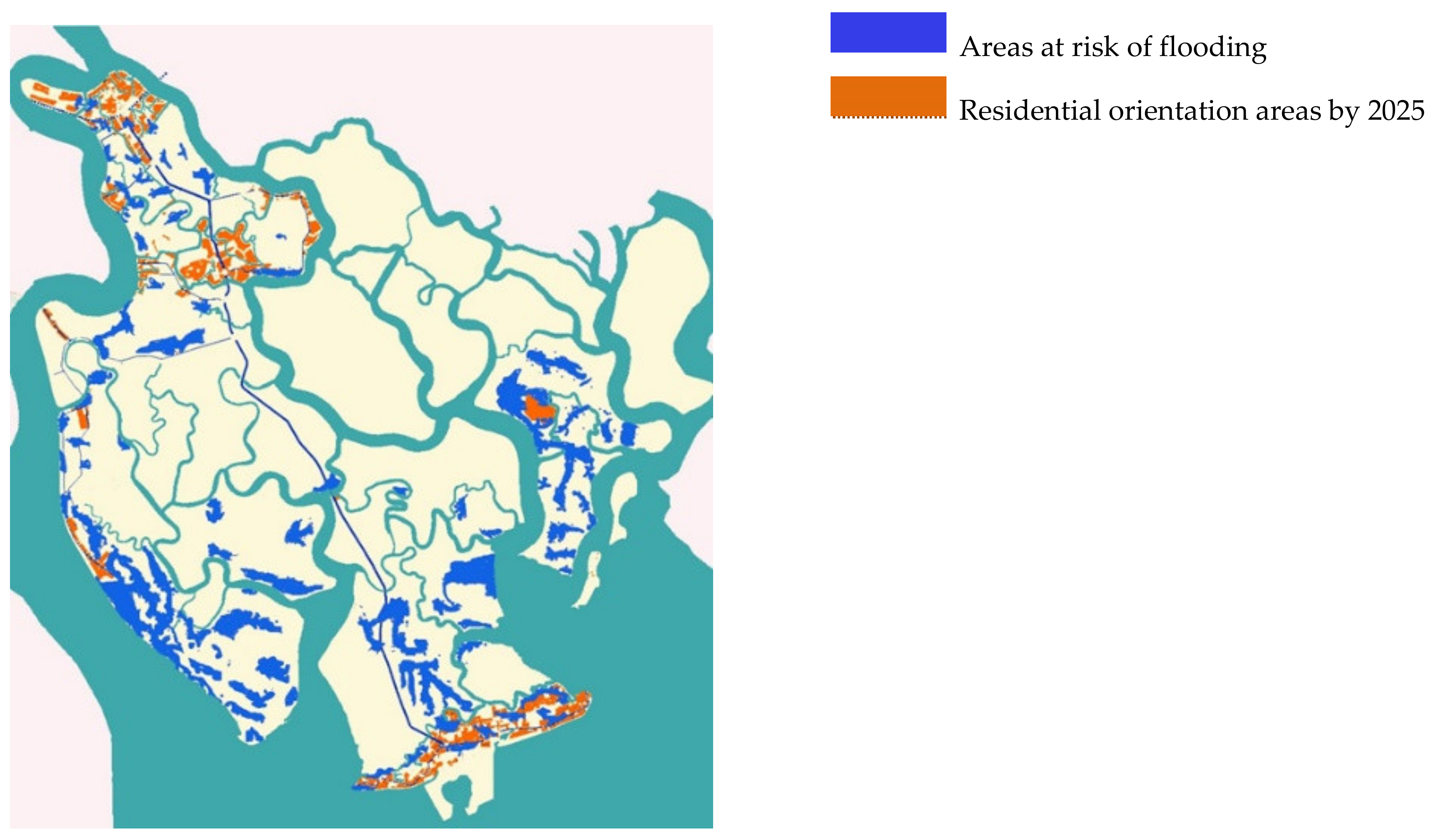
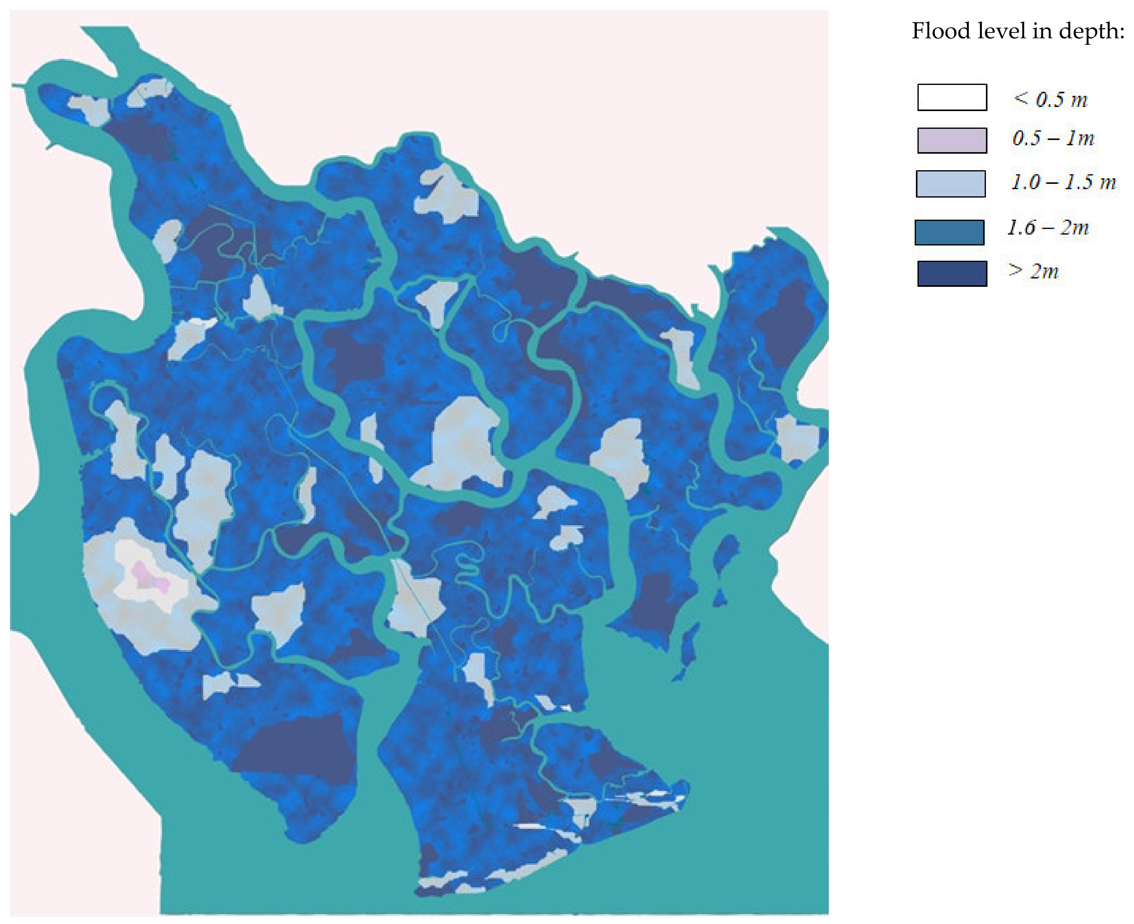
Based on the climate change and SLR scenario of HCMC, many densely populated areas in Can Gio, such as Binh Khanh, Long Hoa, and Thanh An island communes, will be directly affected by SLR by 2025, as seen in
Figure 1. In Can Gio District, the erosion by tides and waves is occurring daily in the coastal strip, including funnel-shaped estuaries (Soai Rap, Dong Tranh, Long Tau) and the long stretch from Dong Hoa cape to Can Gio cape. The average erosion rate ranges from 5 to 12 m per year, with some sections eroding to 22 m per year. Strongly eroded areas include the sand dunes that stretch from Dong Hoa cape to Can Gio cape, Long Tau estuary, and the east bank of Thanh An island commune.
4. Experiences of Adaptive Housing to Sea Level Rise
4.1. Adaptive Architecture
Through the development history of architecture, adaptation has occurred at different levels and scales, and for multiple purposes. In adaptive architecture, “the buildings are particularly designed for adaptations to their surrounding environmental conditions, their inhabitants, and the objects within them either automatically or through human intervention” [
16]. In a comparison between natural evolution and architecture evolution, Nguyen et al. [
17] recognized a similar process of adaptation in architecture that “makes buildings better suited to their climate and their natural and cultural environment”. In architecture, some terms, such as “smart”, “intelligent”, and “interactive”, are used interchangeably with “adaptive” [
18]. Rather than a concept concerning temporal adjustment like “responsive architecture” or involving recovering measures like “resilient architecture”, adaptive architecture is considered a result of a long-term evolution process of several responsive generations. In response to flooding, “aquatecture” is a term used for an architectural typology that mitigates and manages flooding for dynamic and reliable long and short-term solutions [
19].
“Adaptive housing” possesses the mentioned characteristics of adaptive architecture as residential constitutes the primary construction sector in architecture. Responding to flooding, “adaptive housing” improves quality of life through the dynamics in its building design, construction, and operation, as well as by the adaptation to its surrounding landscape design. Therefore, within this paper, “adaptive housing” is discussed from building to block scale.
4.2. Experiences of Adaptive Housing to Sea Level Rise from the Good Practice Examples
In the context of climate change, housing built near seas and rivers with a close connection to sea gates requires a design that is adaptive to the flooding caused by SLR. In Vietnam, tilt, floating, and elevated houses are common housing designs to counteract flooding. Recently, some houses have been built with airtight buoys as a supporting system during flooding. However, due to limitations in material choice, housing design, and budget, as well as the complexity of flood at different places in the country, there are limited good practice cases in Vietnam that can be drawn on for reference for coastal areas like the Can Gio District. Therefore, experiences of good practice from the other countries are preferred as valuable sources of reference. These experiences, with their novel strategies, can help complement the indigenous experiences of adaptive housing, briefly discussed in
Section 5 and contribute to the proposed solutions in
Section 6.
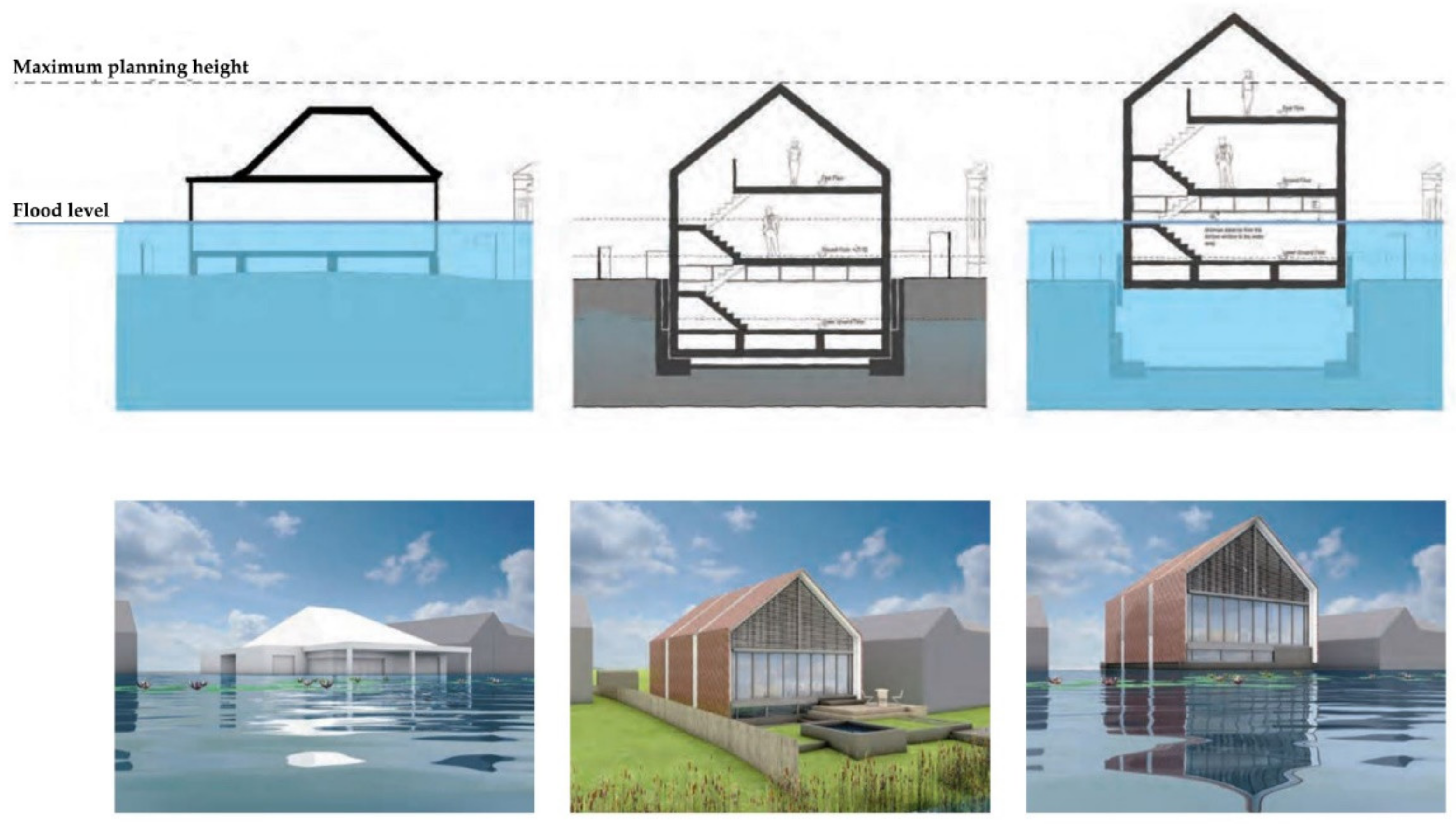
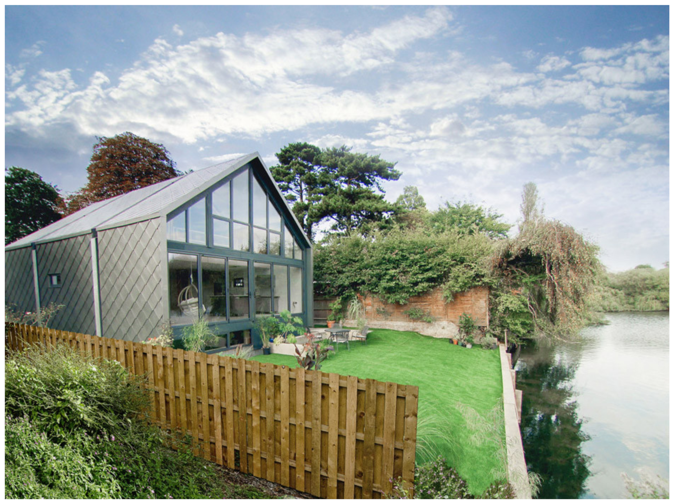
Generally, there are certain approaches to flooding used in various scales from individual housing to multiple housing. In this section, “amphibious house” and “floating house” are mainly discussed. In recent years, perspectives on flood inundation in urban planning, urban design, and architecture have changed. Instead of devising defensive schemes to cope with periodic flooding, water is considered as a resource. “Living on water”—an emerging term in flood adaptation—takes SLR as an opportunity rather than a harmful factor for cities and buildings. According to that, the first amphibious house in the United Kingdom (UK) was built on the banks of the River Thames, England [
20]. It was designed on fixed but separated foundations to be able to float during a flood period, as can be seen in
Figure 2. Its riverside terrace has a water storage function that helps mitigate harm to the interior space, and a flood warning system, as well as supports to manage run-off water, as can be seen in
Figure 3. It also allows homeowners to build their houses closer to riversides or beaches with a lower risk of damage from flooding. In addition, zinc is used as the main coverage material of this house due to its quality in corrosion resistance. Through these integrated approaches, this amphibious house is an innovative adaptation architecture solution to ensure that people can stay inside safely, adapting to the challenges of climate change.
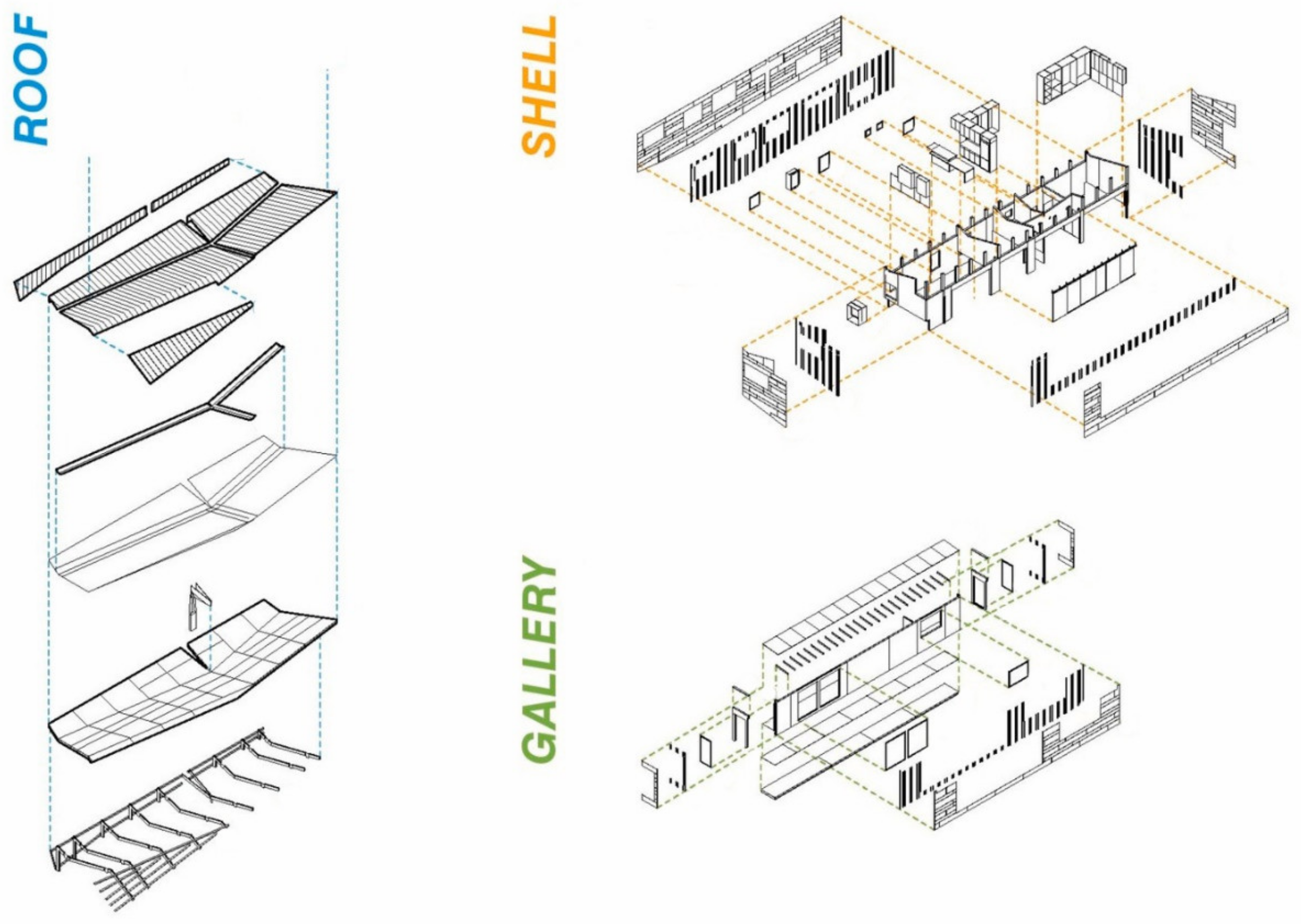
Another good example of an amphibious house is the FLOAT House built in the United State of America (USA). Besides having basic features of an adaptive house to flooding, this building promotes its dynamic chassis customization, affordability by taking advantage of the mass production of prefabricated components, as seen in
Figure 4, and its sustainability by minimizing resource consumption and maximizing renewable energy collection [
21].
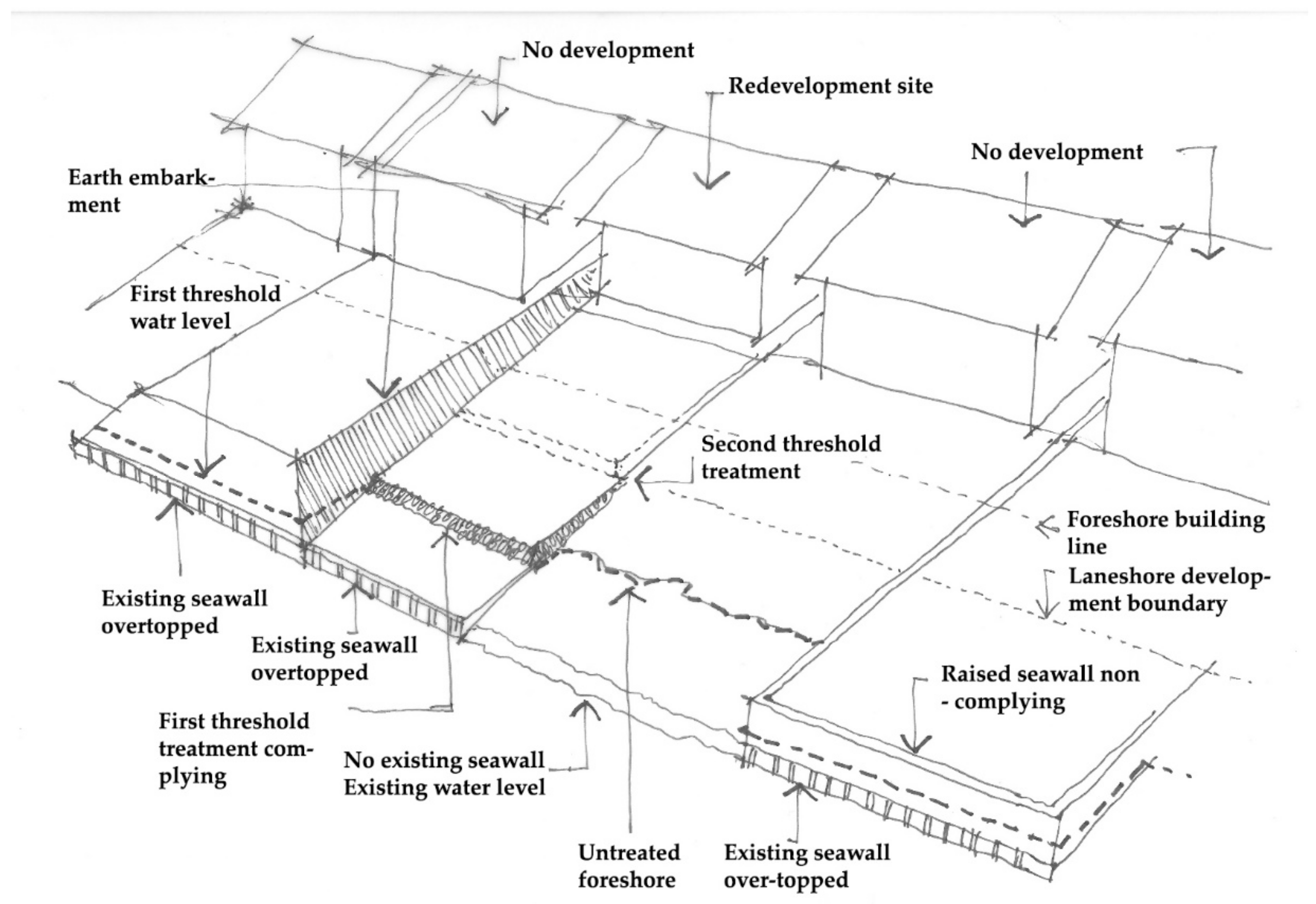
However, large-scale approaches, such as multiple housing, blocks, and neighborhoods, rather than individual houses, are gaining more recognition due to their positive effects and efficiency in economy and timing. Since protection occurs differently in each house, due to their site design, the revised treatments should ensure an effect that is continuous and integrated rather than being disjointed along the foreshore [
23].
Figure 5 shows an example where seawalls should be redeveloped at a fore line in Lake Macquarie, Australia, for a better adaptation to inundation caused by sea level rise.
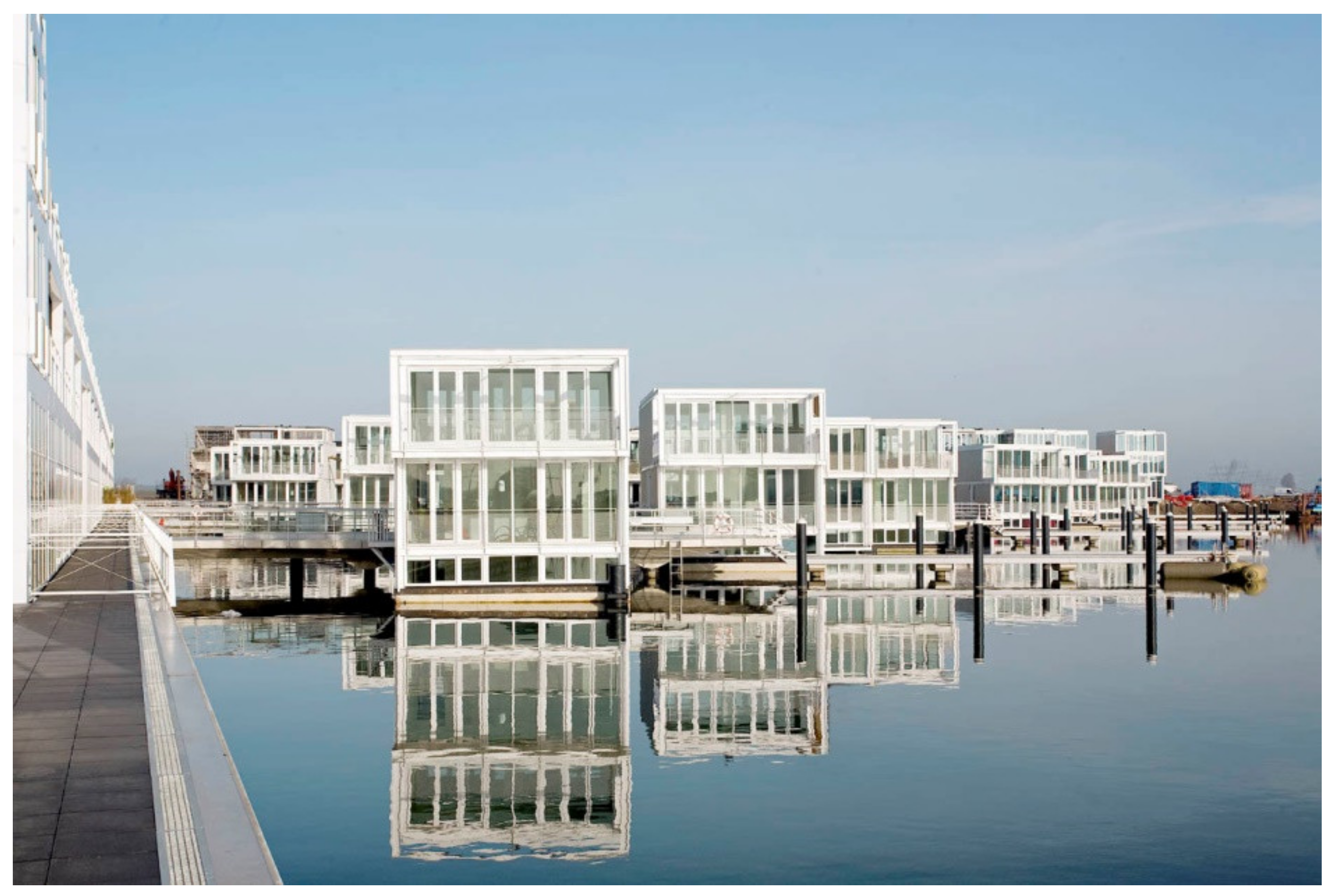
In terms of resiliency and adaptation, the Netherlands is the prime example of a nation that put effort into architectural design in the context of sea and river level rise crisis [
24]. They built housing complexes to promote the transition from land to aquatic living while basic demands are supplied adequately [
19]. Another good example from the Dutch is a group of floating houses in IJburg (
Figure 6). “Floating houses” are different from “amphibious houses” in that they are completely water-based rather than land-based [
25].
Though adaptive housing to flooding, either at an individual or multiple scales, has certain effects, it should be considered within the hierarchy of risk mitigation measures, i.e., avoiding constructing in highly risky locations [
23]. Assessment of adaptive housing is also important, to review the process, control construction quality, revise, and standardize the design for further research, suggestion, and supports.
5. Scientific Foundations for Adaptive Housing to Sea Level Rise in the Can Gio District
To propose adaptive solutions to SLR for housing in Can Gio, this study defines the following relevant scientific foundations concerning multiple aspects.
5.1. The Development of Climate Change Adaptation Strategies in the Can Gio District, Ho Chi Minh City
In 2014, the People’s Committee of HCMC issued the Decision No. 2838/QĐ-UBND on the implementation of the action plan to proactively respond to climate change, strengthen natural resources management, and preserve environmental protection. HCMC’s marine economy benefits from a 17 km long coastline in Can Gio and hundreds of kilometers of riverways. These are favorable for seaport development together with the ebb and flow of high tide that is advantageous for ships. However, developing towards the sea means that HCMC must deal with climate change, especially with flood variation, as seen in
Figure 7.
5.2. Adaptive Traditional Architecture to Natural Conditions
Vietnamese indigenous residential architecture is affected by climate and soil conditions. The residential space is not only located within a house, but also the space surrounding the house. In other words, Vietnamese residential space spreads from the house (the residential area of a family) to the village (the residential area of the community). Traditional residential houses are associated with the natural environment and utilize nature through the construction and organization of indoor and outdoor spaces. Flexibility and adaptation are needed due to the duality of nature (both beneficial and harmful) for harmony with the natural environment. For example, houses along rivers and canals must adapt to the terrain conditions while their structure must also be flexible to cope with flooding.
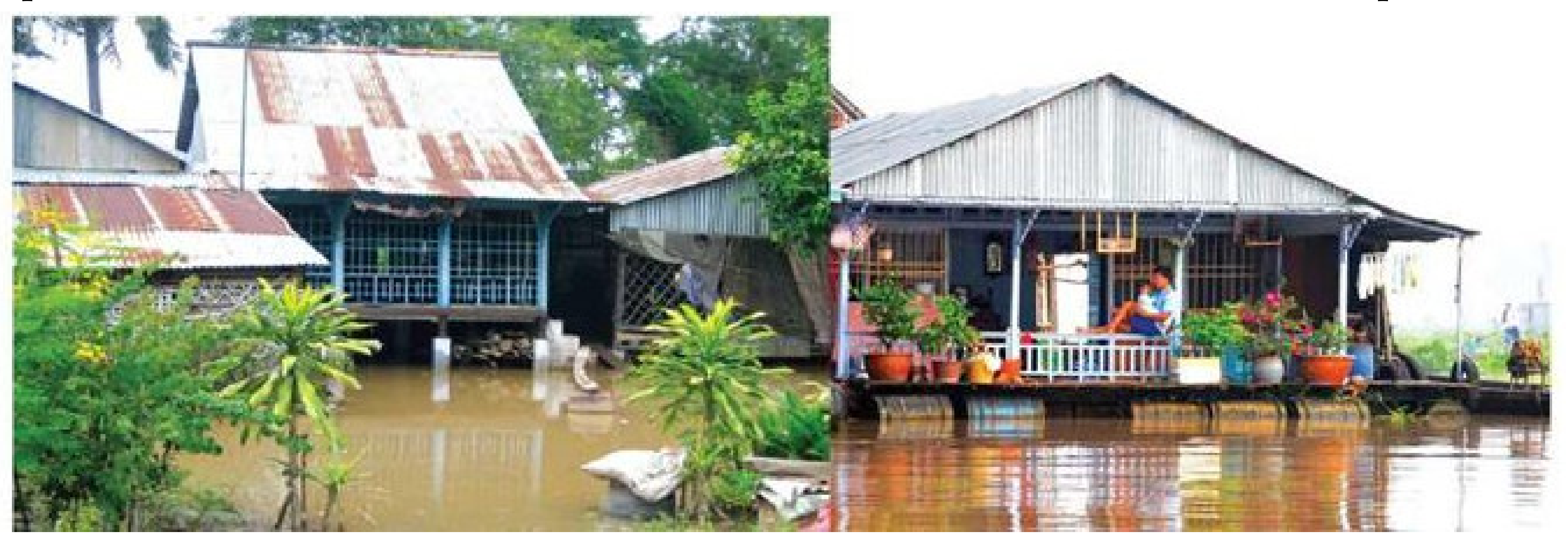
Ancient Vietnamese populations realized the importance of rivers and canals for a residential place. The riverine habitat is not a random choice but rather a practical experience from interacting with the natural environment. River systems have facilitated waterway transport, as well as the flow of water and alluvial into fields. People living by rivers benefit from natural aeration and the water flow for their daily activities such as bathing, washing, catching seafood, exchanging goods, wholesaling, and so on. The most common traditional housing location is a river in front of and a field behind a house. People live together gathered in a long strip along the flow of the river. Another common location is close to the rivers where markets, trade, and exchange of goods takes place, as seen in
Figure 8. People also locate along main roads and riversides. Their partly stilted houses are used for personal activities of families, such as cooking. Both the front and back of the houses are convenient for business and transport.
5.3. Theory of Residential Models for a Sustainable Development
From a sustainable development perspective, the sustainable residence model should have the least impact on the positive viability of all components (including physical and non-structural components) in its surroundings, a minimal environmental impact (direct and indirect) for present and future generations [
2], maximum economic efficiency (direct and indirect), and meet the requirements of developing, renewing, and maintaining local cultural characteristics. The sustainable residence model is the most optimal result of the sustainable design philosophy, with selected design and construction solutions from the construction process to the operational use and the ability to reproduce for use after the project has completed its original purposes.
6. Solutions for Adaptive Housing to Sea Level Rise in the Can Gio District
Based on the mentioned foundations and its current status, the following solutions for adaptive houses to SLR in the Can Gio District are proposed.
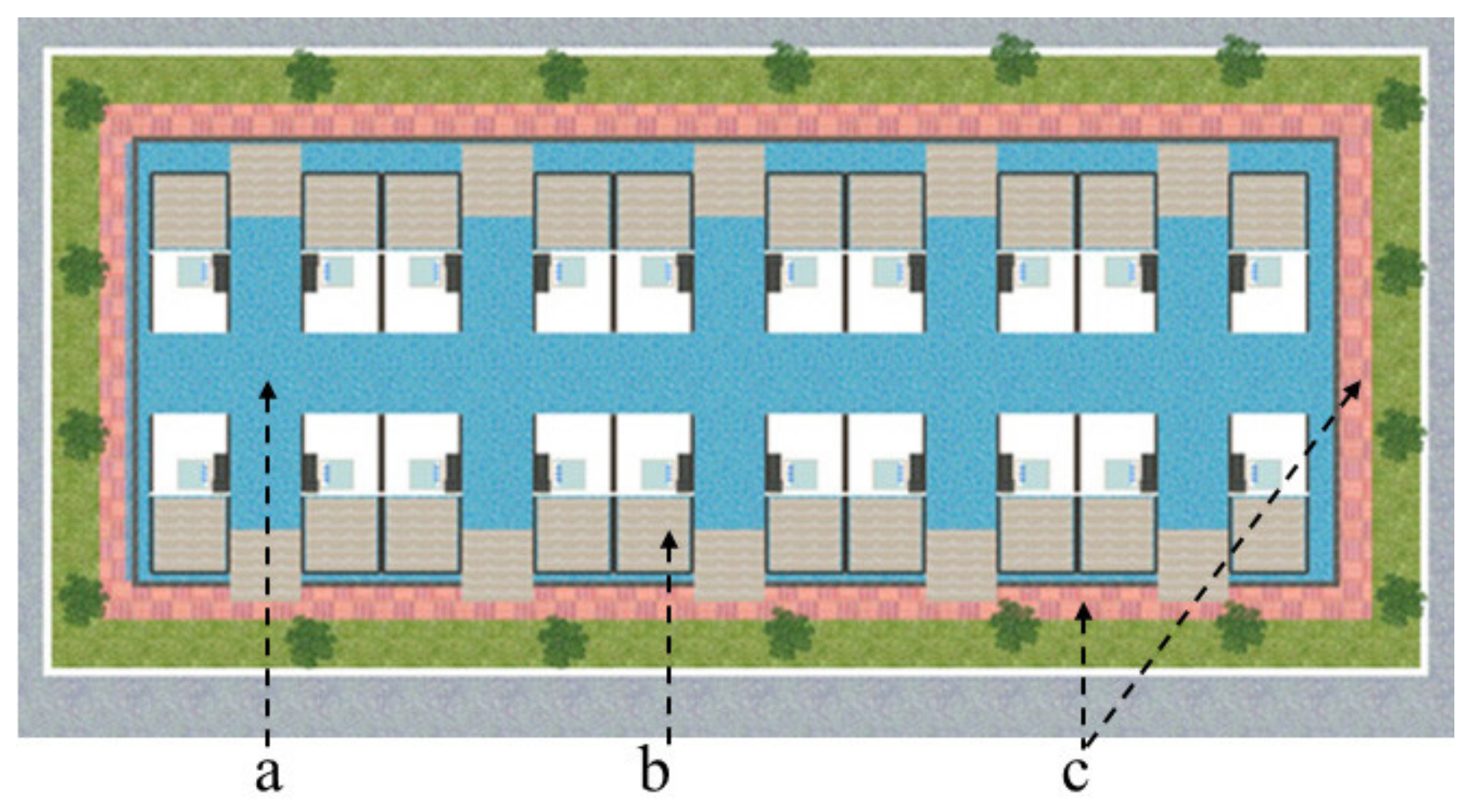
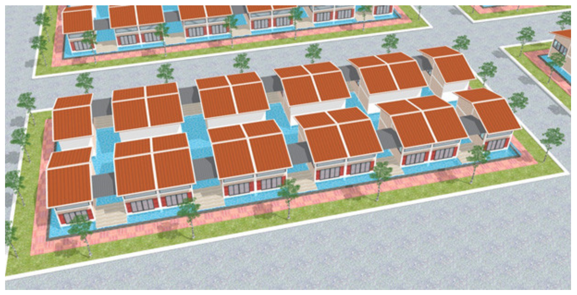
6.1. Saving Space for Water
Temporary water storage can help to lower the flood level. It can be implemented by increasing the volume of water storage space or the inundated area. Besides developing a drainage system, the management of water penetration in populated areas can adapt to SLR and proactively prevent flooding.
When implementing the solution to store water, it is necessary to have an overall vision for each residential area, not just a technical solution for a single house. In other words, the planning solution for all houses in residential areas has a semi-basement design to store water, or all houses in an area are built on a common semi-basement floor sharing the same foundation structure and drainage systems. If each house has its own semi-basement water store, a tank with an area of 30–50 m
2 about 1.0 m below the floor, the amount of reserved water is about 30–50 m
3 per house. If a semi-basement is built for the whole residential area of 1000 m
2 (10 m × 100 m), the amount of water stored is about 1000 m
3. This semi-basement can play the role of an equalizing reservoir during flooding, which was recorded at an average level (30–40 cm high) and for average time (not exceeding 3 h a day), according to data in 2008–2018 [
13]. When there is no flood in the area, this semi-basement can be used for temporary storage, water supply and drainage systems, and private transportation, such as bicycles and motorcycles.
Besides, when the impact of SLR is combined with stormy winds and storm surges, additional artificial drainage ditches in the gardens or along the sidewalks and roads can create extra spaces for water. This will yield a significant amount of water that contributes to lowering the water level. The collected water will be treated by the underground system and drain back to rivers or the sea when the extreme flooding passes. Due to the geological characteristics of Can Gio, with a shallow groundwater system, these designed underground water storage spaces should have a depth of about 0.5 m–1.0 m. This method is illustrated in
Figure 9.
6.2. Floor Elevation
It is proposed to elevate the entire living area beyond the highest floodwater. The area is built on a bare reinforced concrete frame system of about 20–25m
2, which is sufficient for basic activities of a household of 2 to 5 people during the flood. In case other solutions are applied, an elevated floor is recommended for minimum functional spaces such as bedrooms, kitchen, and toilet. Therefore, during flooding, the non-inundated area can still support daily tasks to some extent. These spaces are essential for daily activities that often are forgotten in other suggestions so far. This method is illustrated in
Figure 10.
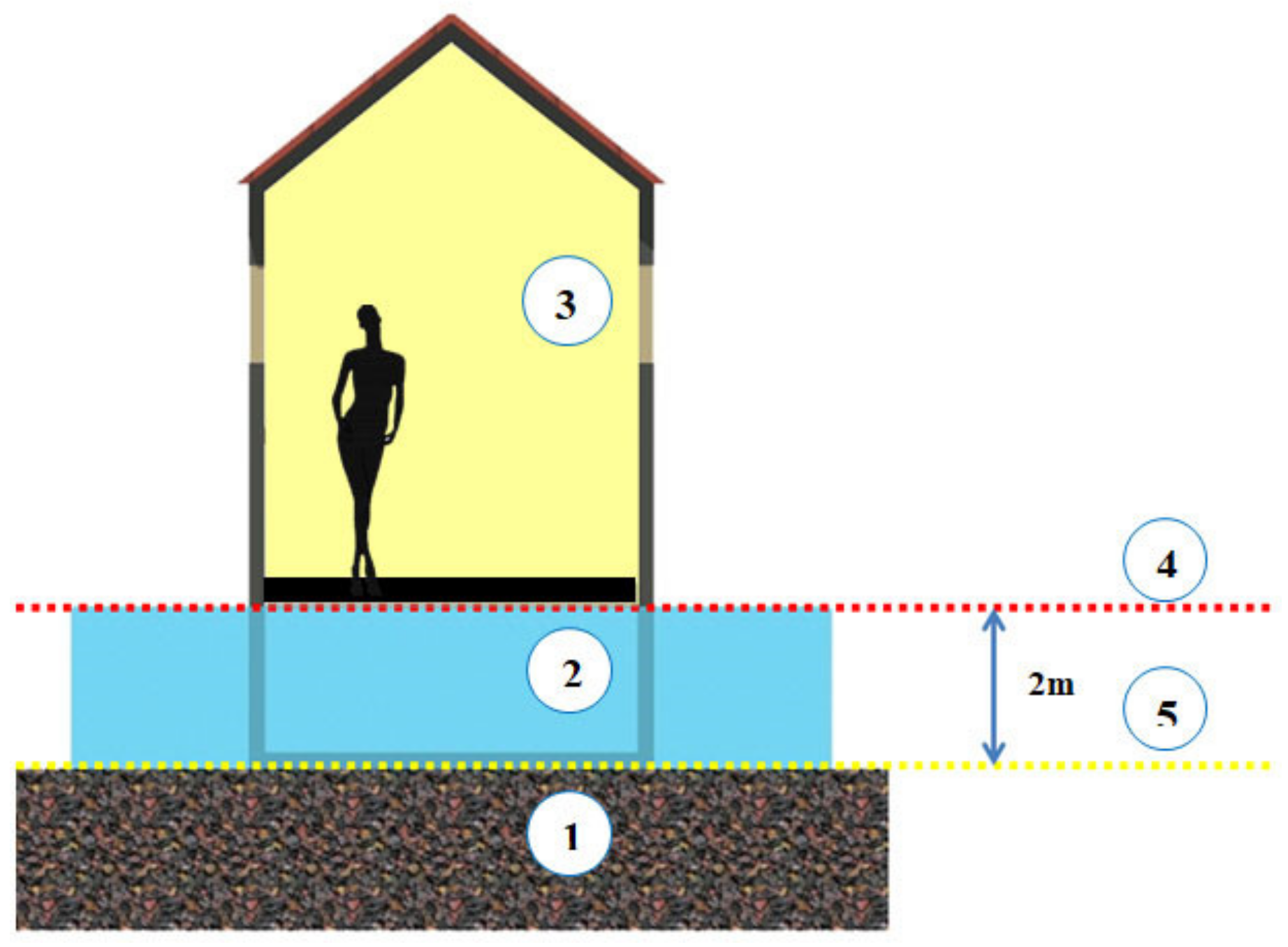
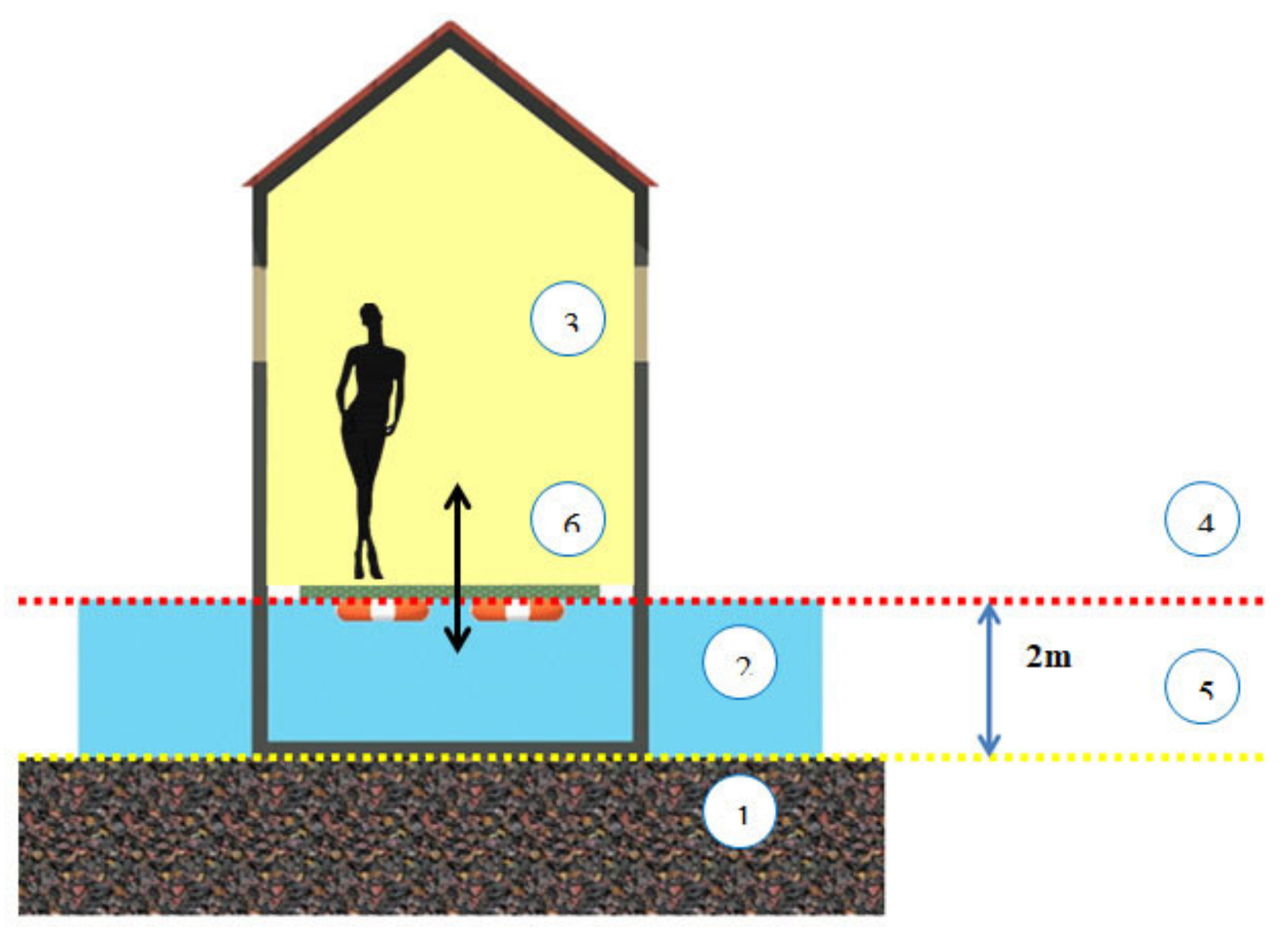
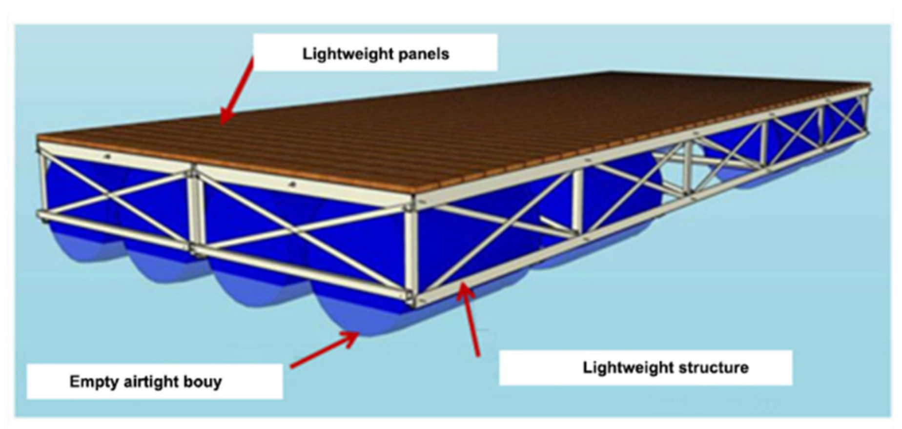
6.3. Floating Floors
The use of floating floors is a flexible solution for adaptive housing to SLR, in which floors rise when water is up. The structural solution is quite simple with lightweight flooring materials placed on a simple structure frame and a floating system below. Specifically designed structures should be used as anchors to balance the floor panels.
Although it has been widely used in the world and Vietnam, as mentioned, this solution should be modified in the Can Gio District because of its geological characteristics. The floating systems of the floor should be elevated on a supporting frame to prevent them from being blocked with mud. Otherwise, when the thick alluvial soil dries up, it may form a solid mass that tightly covers the floating systems and disables their functions. In other words, when the water does not rise, the floor is stuck in the mud, and when the water rises, it takes time for the house to float on its own. This method is illustrated in
Figure 11 and
Figure 12.
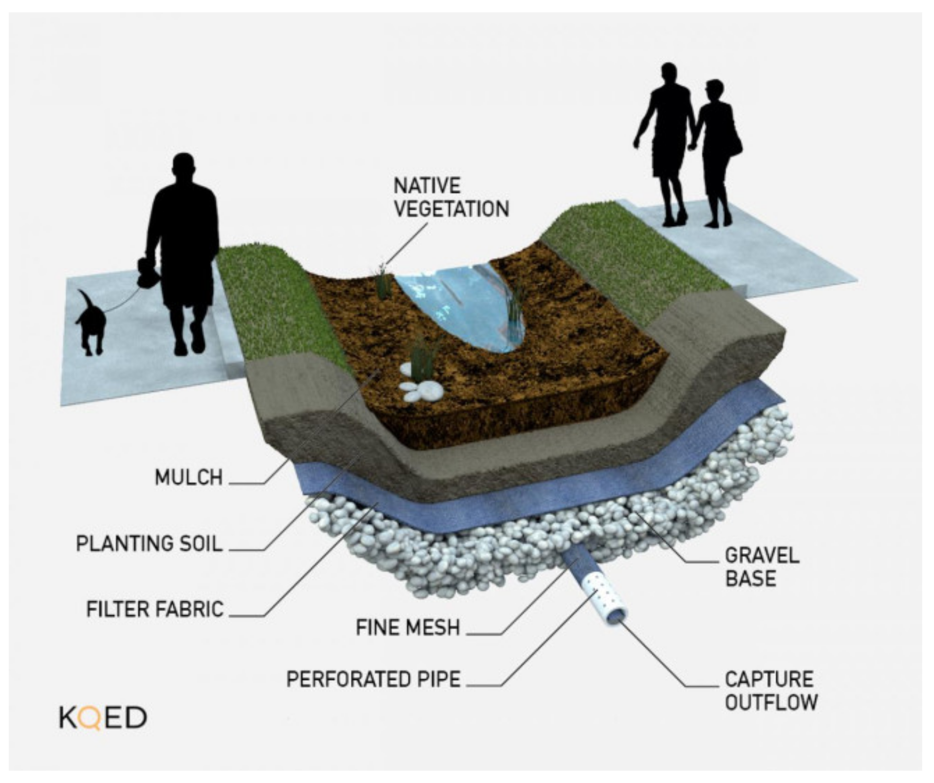
6.4. Bioswale Stormwater Capture
Along with the proposed solution of saving space for water, a system of collecting underground water underneath the roads and natural green spaces can be applied. Overflow water on the sidewalk can be directed to a natural filtration system, also known as a bioswale ditch. It has a slight slope of 1–5% and is covered with layers of grass, vegetation, or compost and layered with rocks and sand at the bottom. The ditch should be shallow and wide to slow down the surface water flow for infiltration and absorption optimization, as can be seen in
Figure 13. This solution can be effective in the coastal areas of Can Gio, where the vegetation on both sides of the road is dense. During rain, most of the water penetrates through the gaps between bricks and sand layers and quickly flows into the sewer to drain into canals and drainage systems, which helps minimize flooding levels due to SLR in the area.
6.5. Solutions for the Linear and Concentrated Residential Areas
In planning, there are two common residential spatial organizations, namely linear and concentrated areas. In which, the linear model applies to residential areas close to natural edges such as water borders, while the concentrated model applies to other areas with a grid network. Due to this characteristic, the linear model has a limited scope of application in terms of locations; however, it is cost-saving for developing technical infrastructure systems, such as electricity supply, water supply and drainage, wastewater treatment, and so on. In the Can Gio District, these solutions can be applied for Dan Xay and Tac Xuat in Can Thanh Town, as they are located along the water edge. Some other population clusters in the Can Gio District are formed according to similarities in their livelihoods. In other words, the households living close to each other may share the same type of business such as trading, tourism, salt manufacturing, or aquaculture (
Figure 14 and
Figure 15). Due to the complexity of its spatial organization, bioswale stormwater capture might be applied for these neighborhoods.
7. Conclusions
By studying the current status of residential areas and housing due to the impact of climate change and SLR in the Can Gio District, negative impacts on houses and the regional economic zone have been found. Therefore, this study explores the experiences of sea level rise adaptive housing and suggests certain solutions for the Can Gio District including the following:
For a single house, the optimal adaptive solutions combine saving space for water, building houses on reinforced concrete frames, and floating floors. The application of these solutions is based on the principle of dividing into areas and controlling flooded areas. Since flooding in the Can Gio District is low in level and duration, saving space for water floor elevation, and bioswale stormwater capture are suitable solutions to the actual situations and technical and economic conditions of the area.
Regarding spatial planning, areas with a linear spatial organization are considered suitable for technical solutions, while bioswale stormwater is more preferred for concentrated organization areas. However, the overall solution of the alternatives is based on planning, zoning, and flood control combined with the organization of appropriate technical infrastructure.
The original and practical contributions of this research are the scientific foundations for the proposed adaptive housing to SLR in the Can Gio District and the designs for flexible and adaptable living spaces that aim to ensure residents’ safety, properties, and livelihood. The designs were created by groups of postgraduate architecture students, who were led by the corresponding author during 2017–2019.
The proposed solutions for the Can Gio District in this publication attempt to increase the possibilities to adapt to flooding and increasing sea level, which can help reduce the vulnerability for the communities in the affected areas. Besides the limitations of the applied solutions, these proposals seek further opportunities to deal with the threats caused by climate change and sea level rise. Moreover, the local capacities for strategies to retreat, defend, and prevent flooding should be considered in flood management. Finally, the proposed solutions for architecture, planning, and infrastructure can be applied practically to other flooded areas in Vietnam, as well as referenced in future research.
Author Contributions
Conceptualization, L.-M.N. and L.T.K.; formal analysis, H.-Y.H.; Methodology, L.-M.N.; Project administration, H.-Y.H.; Resources, H.-B.N.; Software, H.-B.N.; Writing—original draft, L.-M.N. and L.T.K.; Writing—review & editing, L.-M.N. and L.T.K. All authors have read and agreed to the published version of the manuscript.
Funding
This research received no external funding.
Acknowledgments
A portion of the research for this paper was conducted by Le-Minh Ngo which was made possible by a 2018–2020 Ho Chi Minh City Department of Science and Technology Grant. Le-Minh Ngo also wishes to thank Ton Duc Thang University for hosting the research activities, and to the students and lecturers who participated in the research. Among the contributions, adaptive solutions were designed and illustrated by the masters students of architecture, under the supervision of Le-Minh Ngo, in 2017–2019.
Conflicts of Interest
The authors declare no conflicts of interest.
References
- Hanson, S.; Nicholls, R.; Ranger, N.; Hallegatte, S.; Corfee-Morlot, J.; Herweijer, C.; Chateau, J. A global ranking of port cities with high exposure to climate extremes. Clim. Chang. 2011, 104, 89–111. [Google Scholar] [CrossRef]
- Phan, V.T.; Ngo, D.T. Climate Change in Vietnam: Some research results, challenges and opportunities in international integration. J. Sci. VNU Earth Environ. Sci. 2013, 29, 42–55. [Google Scholar]
- Ghozali, A.; Ariyaningsih; Sukmara, R.B.; Aulia, B.U. A Comparative Study of Climate Change Mitigation and Adaptation on Flood Management between Ayutthaya City (Thailand) and Samarinda City (Indonesia). Procedia Soc. Behav. Sci. 2016, 227, 424–429. [Google Scholar] [CrossRef]
- Shrestha, S.; Lohpaisankrit, W. Flood hazard assessment under climate change scenarios in the Yang River Basin, Thailand. Int. J. Sustain. Built Environ. 2017, 6, 285–298. [Google Scholar] [CrossRef]
- Didovets, I.; Krysanova, V.; Bürger, G.; Snizhko, S.; Balabukh, V.; Bronstert, A. Climate change impact on regional floods in the Carpathian region. J. Hydrol. Reg. Stud. 2019, 22, 100590. [Google Scholar] [CrossRef]
- Dewan, T.H. Societal impacts and vulnerability to floods in Bangladesh and Nepal. Weather Clim. Extrem. 2015, 7, 36–42. [Google Scholar] [CrossRef]
- Kaspersen, P.S.; Halsnæs, K. Integrated climate change risk assessment: A practical application for urban flooding during extreme precipitation. Clim. Serv. 2017, 6, 55–64. [Google Scholar] [CrossRef]
- Ford, A.; Barr, S.; Dawson, R.; Virgo, J.; Batty, M.; Hall, J. A multi-scale urban integrated assessment framework for climate change studies: A flooding application. Comput. Environ. Urban Syst. 2019, 75, 229–243. [Google Scholar] [CrossRef]
- Giupponi, C.; Giove, S.; Giannini, V. A dynamic assessment tool for exploring and communicating vulnerability to floods and climate change. Environ. Model. Softw. 2013, 44, 136–147. [Google Scholar] [CrossRef]
- Mohit, M.A.; Sellu, G.M. Mitigation of Climate Change Effects through Non-structural Flood Disaster Management in Pekan Town, Malaysia. Procedia Soc. Behav. Sci. 2013, 85, 564–573. [Google Scholar] [CrossRef][Green Version]
- Alves, A.; Sanchez, A.; Gersonius, B.; Vojinovic, Z. A Model-based Framework for Selection and Development of Multi-functional and Adaptive Strategies to Cope with Urban Floods. Procedia Eng. 2016, 154, 877–884. [Google Scholar] [CrossRef]
- Yamashita, S.; Watanabe, R.; Shimatani, Y. Smart Adaptation to Flooding in Urban Areas. Procedia Eng. 2015, 118, 1096–1103. [Google Scholar] [CrossRef][Green Version]
- Nguyen, X.D. Addressing Three Basic Issues to Combat Flooding in Ho Chi Minh City; Vietnam News Agency: Ho Chi Minh City, Vietnam, 2018. [Google Scholar]
- Nguyen, K.P.; Le, V.T. Calculating Model of Impact Factors of Climate Change Used in Land Used, Transportation, Water Resources and Infrastructure Planning for Ho Chi Minh City; Ho Chi Minh City Department of Planning and Architecture: Ho Chi Minh City, Vietnam, 2011. [Google Scholar]
- Truong, N.T.N. A Study on Adaptive Residential Model to Sea Level Rise in Can Gio District, Ho Chi Minh City. Master’s Thesis, Ho Chi Minh City University of Architecture, Ho Chi Minh City, Vietnam, 2018. [Google Scholar]
- Schnädelbach, H. Adaptive Architecture—A Conceptual Framework. In Proceedings of the MediaCity: Interaction of Architecture, Media and Social Phenomena Conference, Bauhaus-Universität Weimar, Weimar City, Germany, 29–31 October 2010. [Google Scholar]
- Nguyen, A.T.; Reiter, S. Bioclimatism in architecture: An evolutionary perspective. Int. J. Des. Nat. Ecodynamics 2017, 12, 16–29. [Google Scholar] [CrossRef]
- Thun, G.; Velikov, K. Responsive Envelopes: Characteristics and Evolving Paradigms. In Design and Construction of High Performance Homes: Building Envelopes, Renewable Energies and Integrated Practice; Routledge: London, UK, 2012; pp. 75–92. ISBN 0-415-61528-3. [Google Scholar]
- Williams, E. Aquatecture: Architectural Adaptation to Rising Sea Levels. Master’s Thesis, University of South Florida, Tampa, FL, USA, 2009. [Google Scholar]
- Coutts, R.; Barker, R. Shortlisted 2016: Design and Technical. UK’s First Amphibious House. Can-Float Amphibious Building; RIBA: London, UK, 2017. [Google Scholar]
- Mairs, J. Baca Architects Completes Buoyant House on the River Thames. Available online: https://www.dezeen.com/2016/01/20/baca-architects-bouyant-amphibious-house-river-thames-buckinghamshire-floating-architecture/ (accessed on 11 September 2019).
- Alarcón, J. The FLOAT House—Make it Right/Morphosis Architects. Available online: http://www.archdaily.com/259629/make-it-right-house-morphosis-architects/ (accessed on 4 April 2020).
- Giles, G. Adaptation by Design—Adapting New Buildings and Foreshore Protection Works to Sea Level Rise in Coastal Estuaries. In Proceedings of the 21st NSW Coastal Conference, The Pavilion, Kiama, NSW, Australia, 6–9 November 2012. [Google Scholar]
- Shannon, E. Resilient Architecture: Adaptive Community Living in Coastal Locations. Master’s Thesis, University of Massachusets Amherst, Amherst, MA, USA, 2018. [Google Scholar]
- Moon, C. A Study on the Floating House for New Resilient Living. J. Korean Hous. Assoc. 2015, 26, 97–104. [Google Scholar] [CrossRef]
- Architectenbureau Marlies Rohmer Floating Houses in Ijburg/Architectenbureau Marlies Rohmer. Available online: http://www.archdaily.com/120238/floating-houses-in-ijburg-architectenbureau-marlies-rohmer/ (accessed on 12 September 2019).
- Tran, H.A.; Le, A.T. What are Reality for Housing Construction for Floodplains in the Mekong Delta? Available online: http://kientrucvietnam.org.vn/xay-dung-nha-o-vung-lu-cho-dbscl-can-nhin-vao-nhung-thuc-te-gi/ (accessed on 4 April 2020).
© 2020 by the authors. Licensee MDPI, Basel, Switzerland. This article is an open access article distributed under the terms and conditions of the Creative Commons Attribution (CC BY) license (http://creativecommons.org/licenses/by/4.0/).


