Community and Impact Based Early Warning System for Flood Risk Preparedness: The Experience of the Sirba River in Niger
Abstract
1. Introduction
2. Materials and Methods
2.1. Study Area and the Hydrological Context
2.2. Methods for System Set-Up
2.2.1. Risk Knowledge: Risk Assessment at Local Level and Flood Scenarios
2.2.2. Monitoring and Warning Service: Hydrological Observations and Forecasts, Data and Information Management
2.2.3. Dissemination and Communication: Stakeholders’ Consultation
2.2.4. Response Capability: Communities Preparedness and Action
3. Results
3.1. Risk Knowledge
3.2. Monitoring and Warning Service
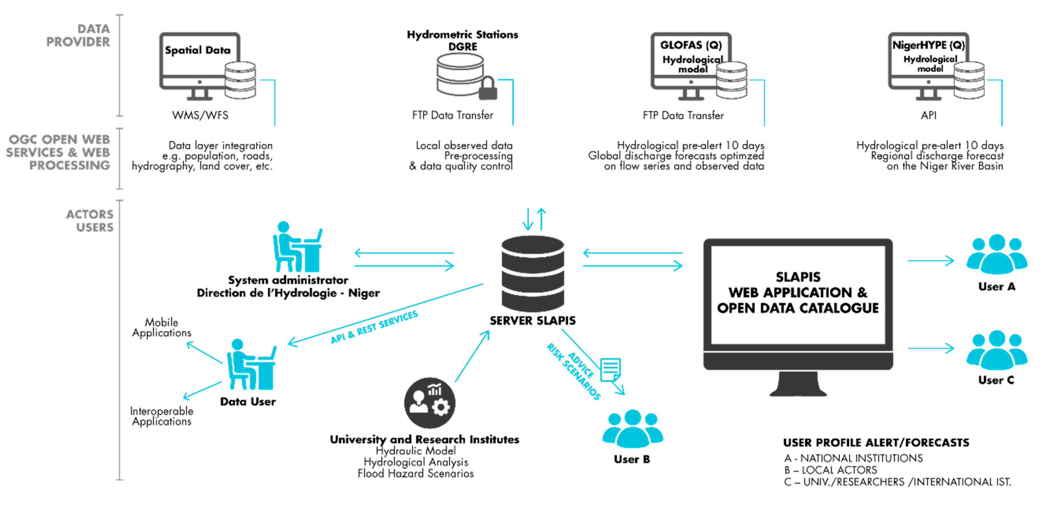
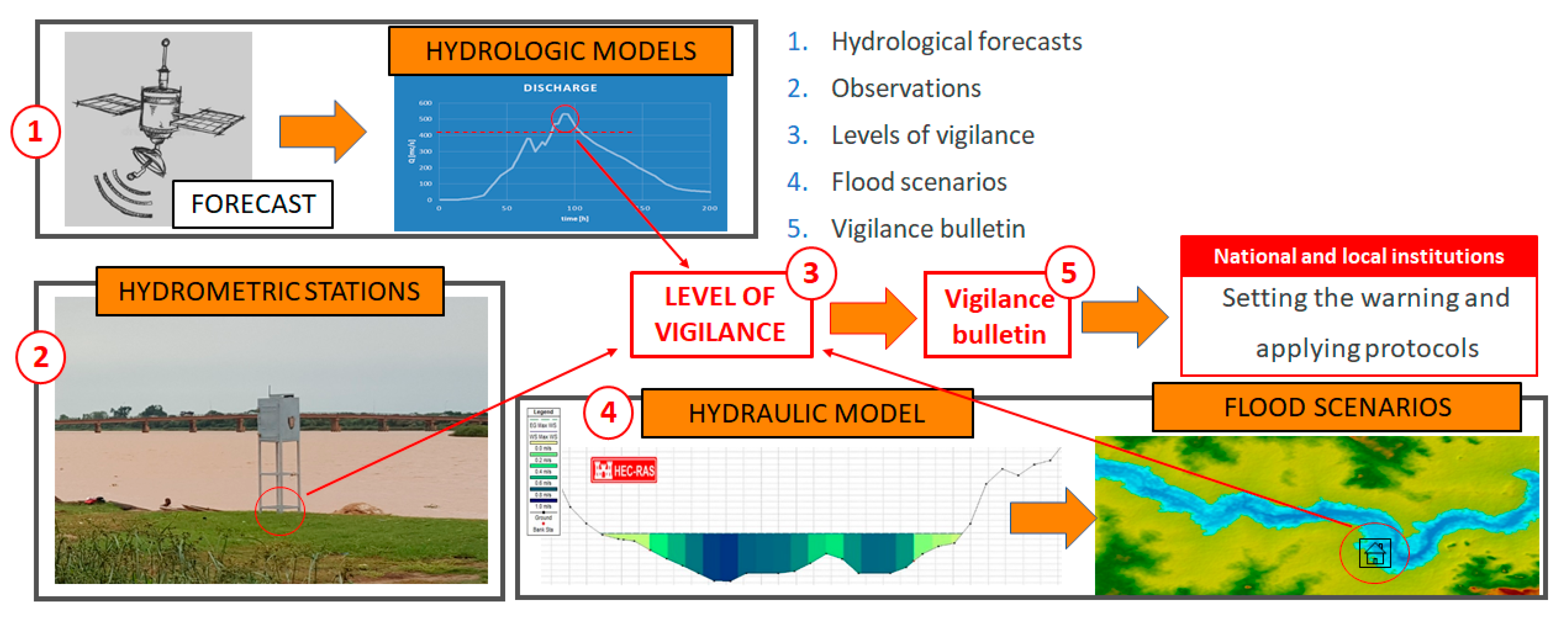
- Forecasts: the system downloads the daily forecasts from hydrological models (GloFAS and Niger-HYPE) and stores them in the central Postgres geodatabase. Data are postprocessed according to the optimization procedures and finally shown as the discharge in a graphic format (currently only GloFAS);
- Observations: the system downloads real-time observations from hydrometric stations each hour and stores them in the Postgres geodatabase. Data are shown as the water height and discharge in both graphs and tables;
- Levels of vigilance: levels of vigilance are set by the system once the thresholds are exceeded on observed data at the upstream station;
- Flood scenarios: the system automatically displays on the map the flood scenario related to the exceeded vigilance threshold;
- Vigilance bulletin: Exceedances in hazard thresholds activate a vigilance bulletin in the system and an automatic email message to the Directorate of Hydrology. The vigilance bulletins can be used as they are or can be edited to activate the alerting chain of national and local authorities, as defined by the National Alert Code.
3.3. Dissemination and Communication
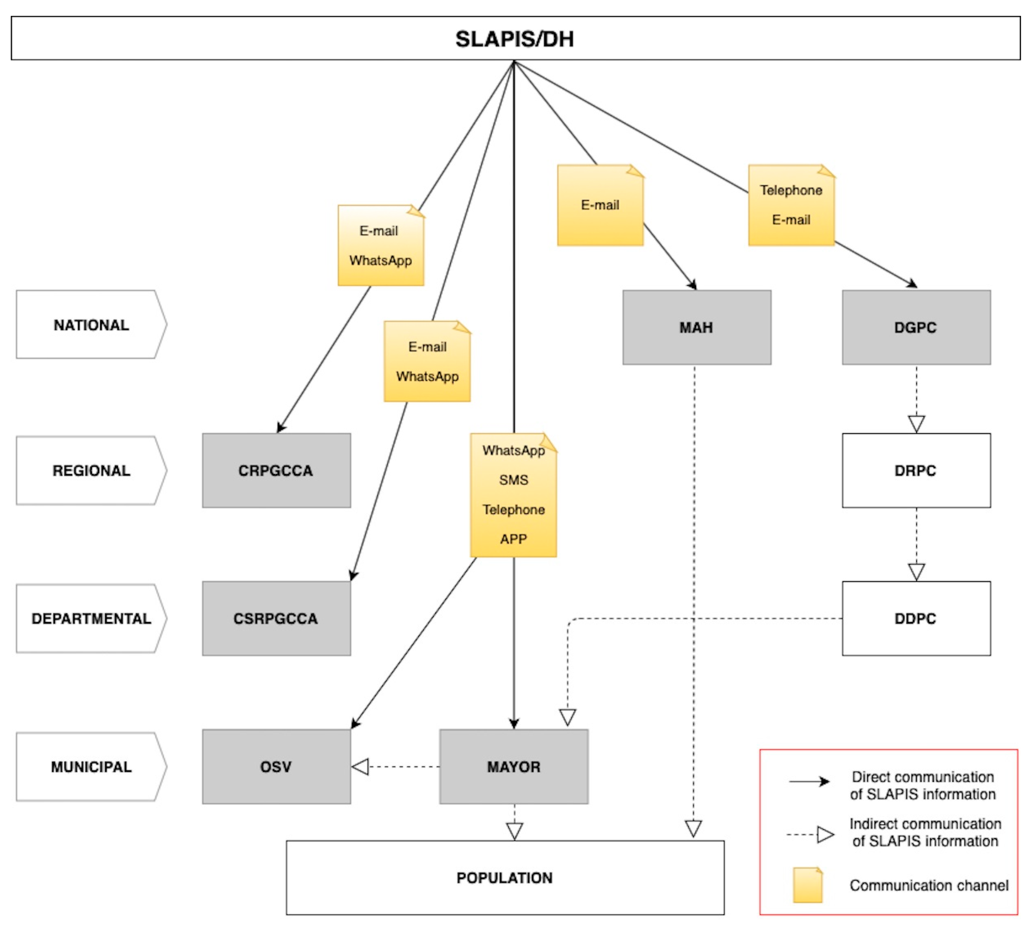
- To Civil Protection Directorate (DGPC) at a central level, that sends the alert to the Regional Directorate, then to the Departmental Directorate, which then communicates it to the Mayor;
- To the National Food Crisis Prevention and Management System (DNPGCA) at central level, that sends the alert to the Regional Committee (CRPGCA), then to the Departmental Committee (CSRPGCA), who communicates it to the Mayor;
- To the Ministry of Humanitarian Action and Disaster Management (MAH) which, not having any de-centered structure, transmits the alert via all the means of communication provided by the National Alert Code to all levels including the population.
- To the Mayor of affected municipalities who, once he has received the information concerning the level of vigilance, alerts:
- o
- The OSV through an emergency meeting. The OSV alerts sectoral infrastructure (schools, water supply, etc.);
- o
- Community Radio by telephone to dictate an alert release;
- o
- Chiefs of concerned villages by telephone. The village chief mobilizes all available means to alert the population (loudspeaker, town crier, etc.);
- o
- The Prefecture by telephone and/or SMS;
- o
- SCAP-RUs (through the OSV).
3.4. Response Capability: Communities Preparedness and Action
4. Discussion
- Local risk assessment—interaction of vulnerability and hazard scenarios for determining the risk to the exposed elements with a detailed resolution [66]: this is a key element to connect top-down and bottom-up approaches. It was addressed through participatory local risk assessment for main localities along the river [44] and flood hazard scenarios, including hazard thresholds and flooding areas [27,44];
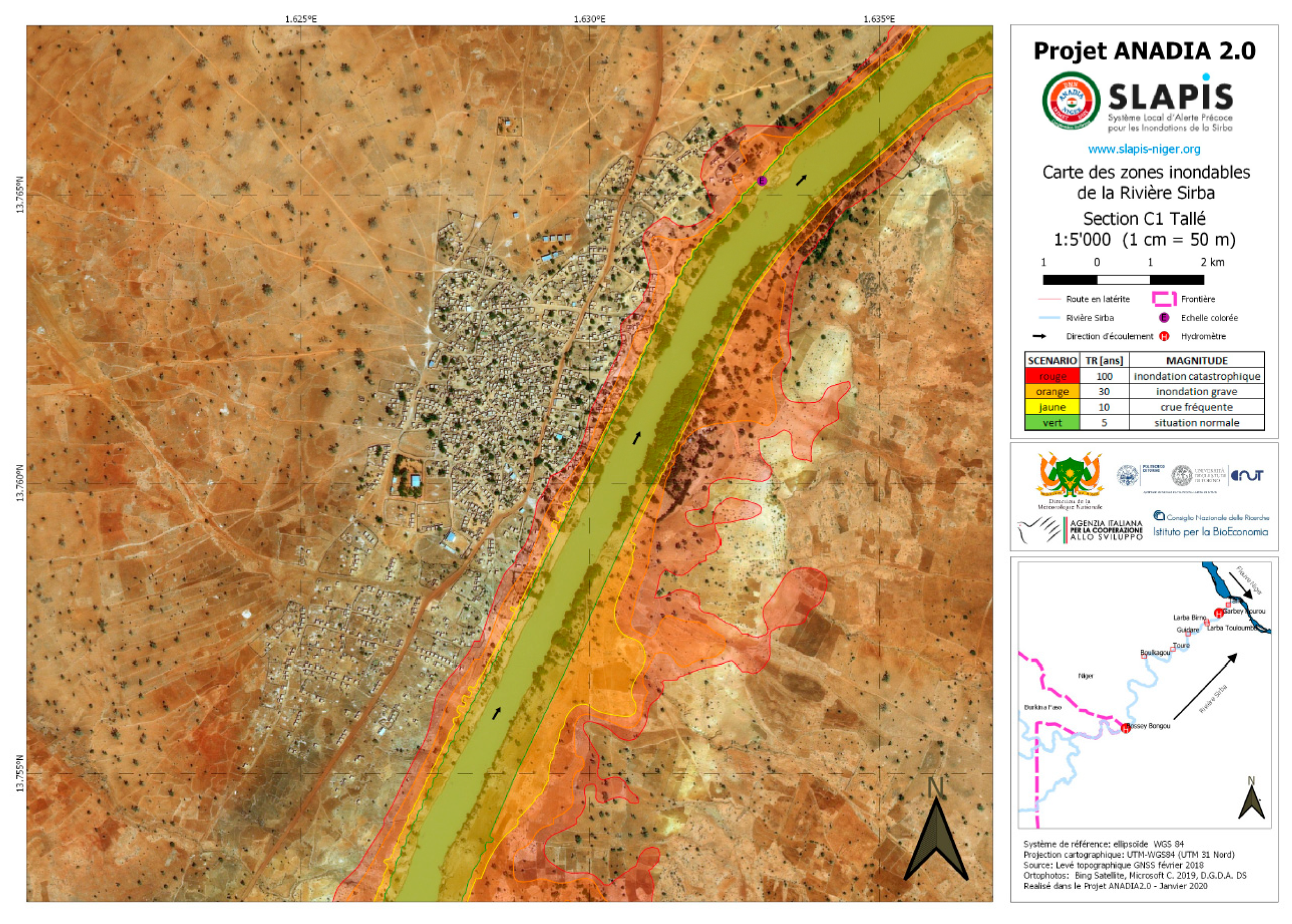
- Hazard mapping—hazard maps for different scenarios need to be developed to identify exposure to different hazard magnitudes [61,67]: flood hazard scenarios were mapped (www.slapis-niger.org) and an Atlas of flood-prone areas of the Sirba river produced (see Supplementary Materials);
- Vulnerability mapping—vulnerable elements and critical infrastructure need to be mapped, documented and periodically updated [68]: this point was addressed through the involvement of municipalities in listing, georeferencing and describing assets for each flood scenario in the main localities [44,60]; for future sustainability, the challenge is to keep the lists updated, which mostly depends on the willingness of the municipalities involved.
- Timely and accurate forecast—good quality data have to be collected and processed in real or quasi-real-time to produce meaningful, timely and accurate forecasts [3]: hydrological forecasts can ensure a lead time of 10 days, but their accuracy is lower than hydraulic forecasts based on the upstream hydrometer [27], which have a lead time of 28 hours. The accuracy of hydrological forecasts has been improved, assimilating real-time data observed at the gauging stations at Bossey Bangou and Garbey Kourou;
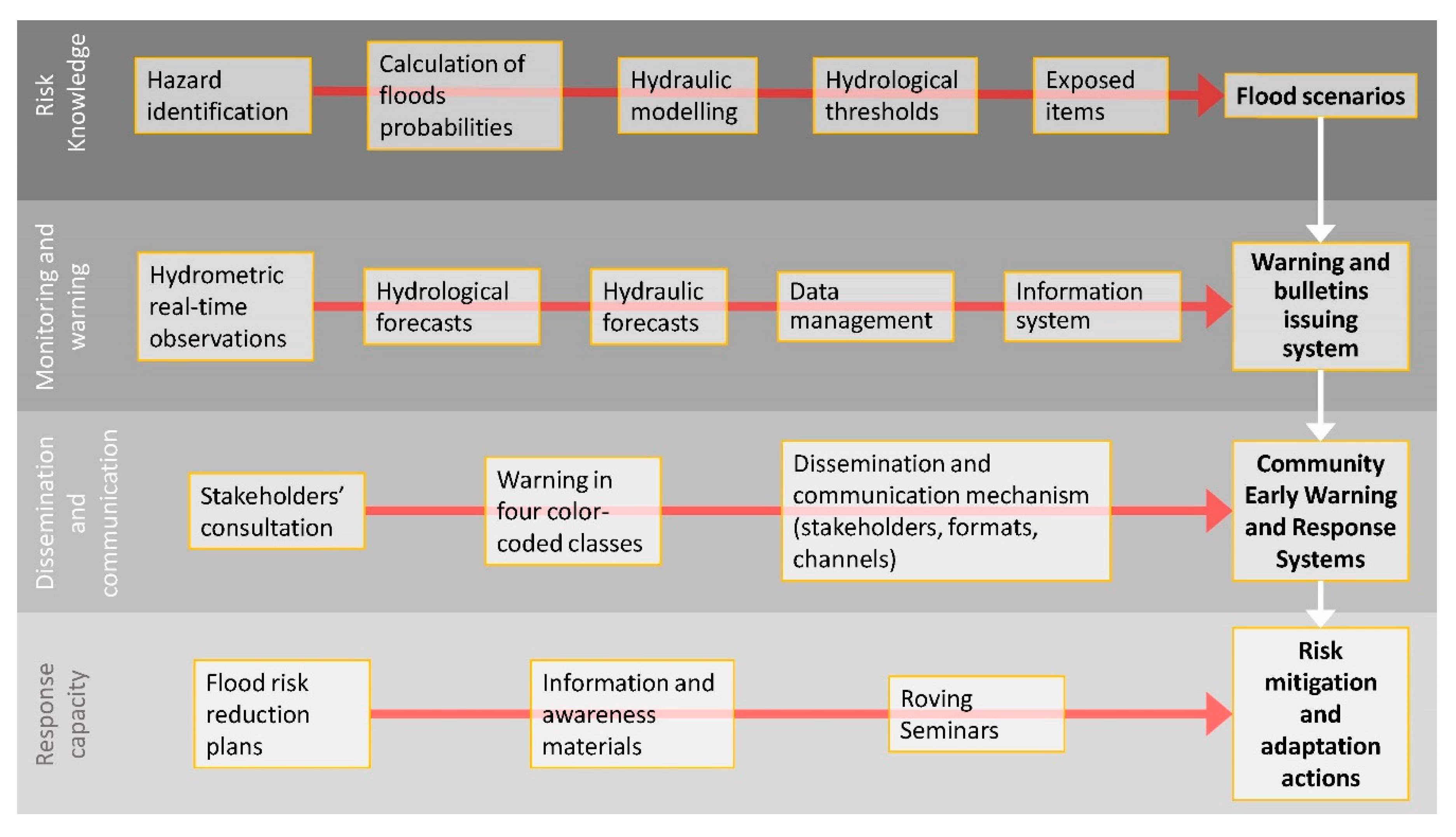
- Impact-based thresholds—warnings must be prepared and issued based on expected impacts severity, enabling end-users to take appropriate risk mitigation actions [17]: SLAPIS Hydrological warnings are based on four color-coded classes related to flood scenarios and assets at flood risk [27,44]. For citizens already used to that approach, the meaning is intuitive, but in a Sahelian rural area, the understanding is not evident. Indeed, many awareness-raising activities have been organized with local communities;
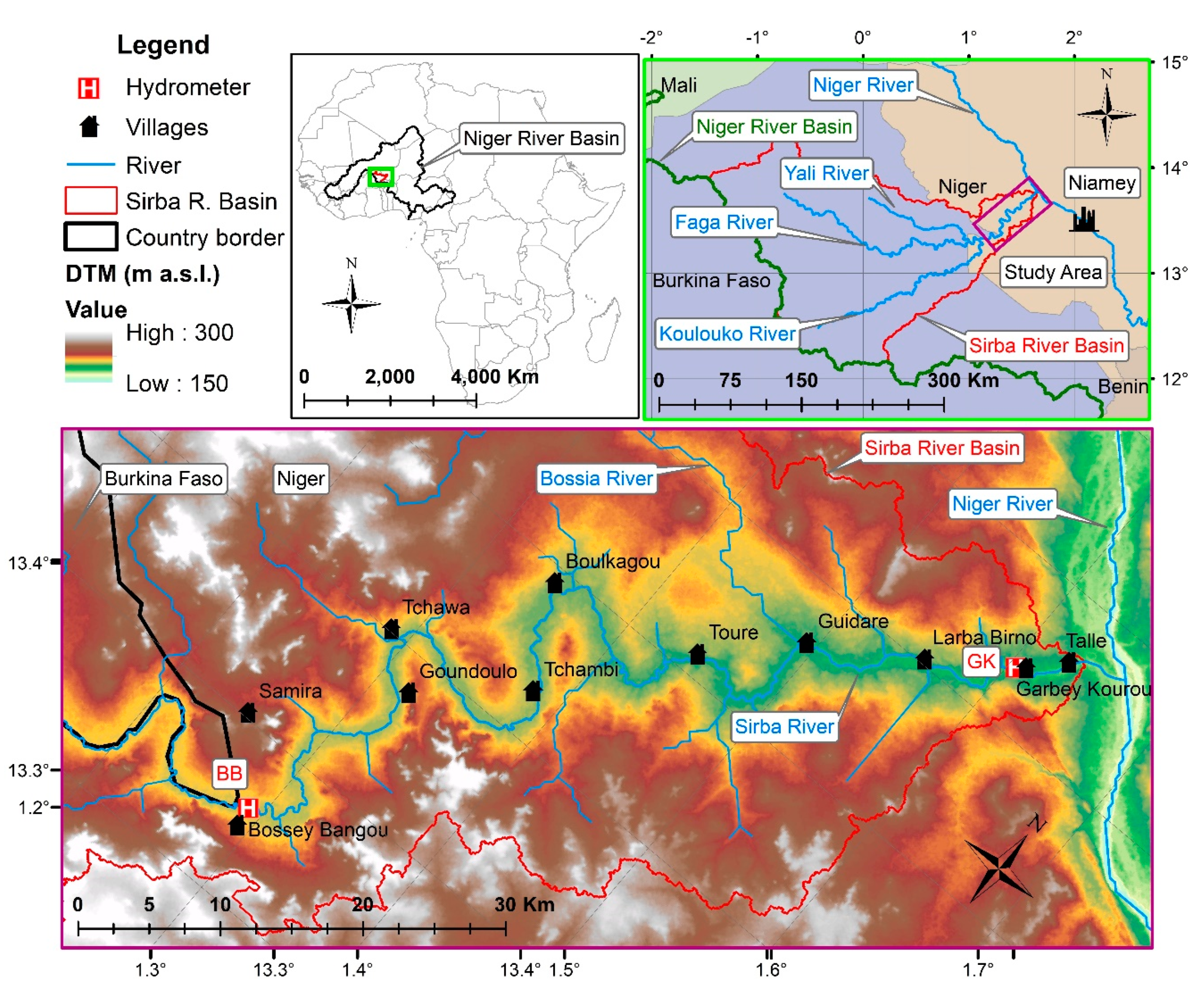
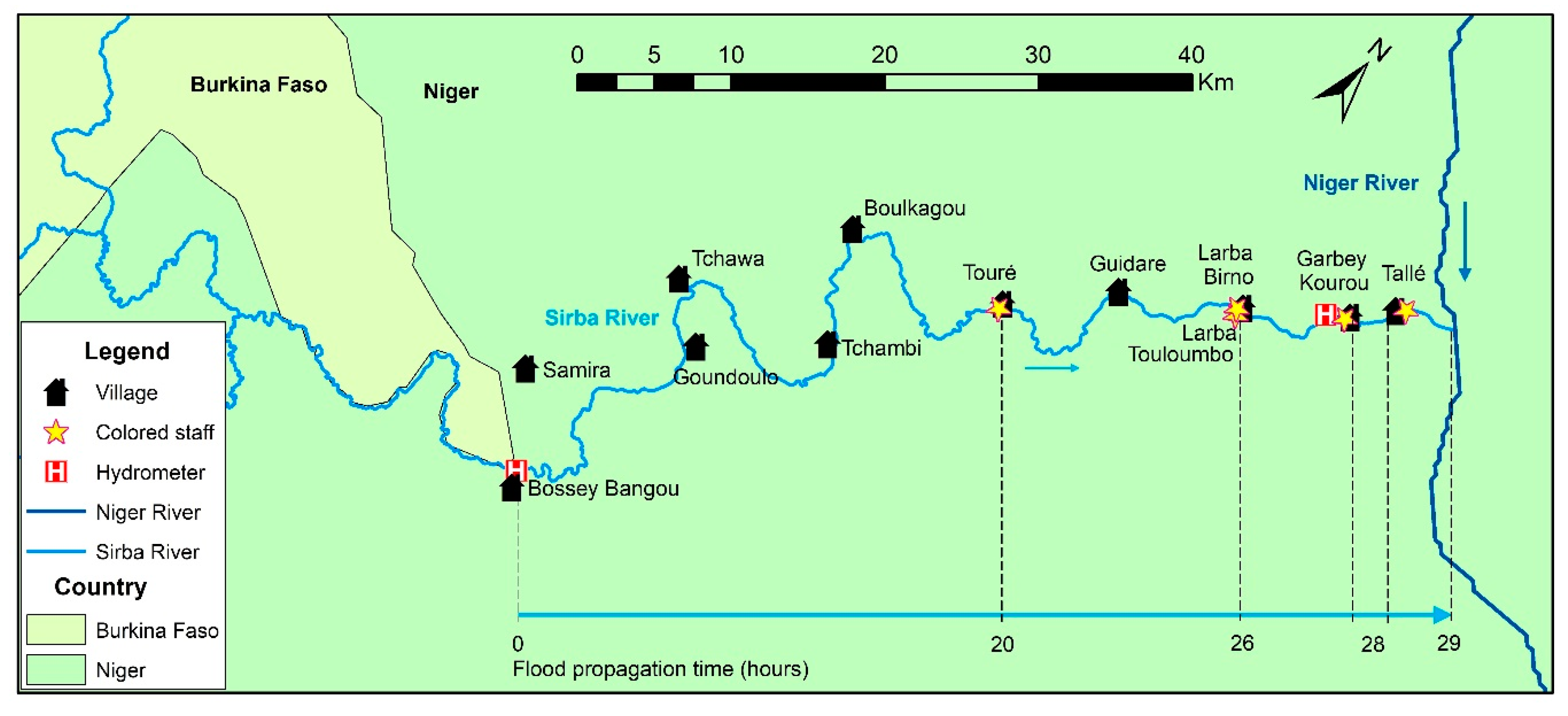
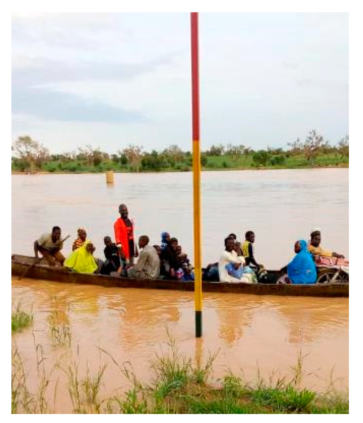
- Geographic-specific warnings—a dense monitoring network ensures a good coverage of the forecast, being more specific and issuing warnings to localized targets [65,67,69]: addressed by two automatic hydrometers on the Sirba river (108 km distance = ~ 28 hours. propagation time) at Bossey Bangou (13.73° N, 1.60° E) and Garbey Kourou (13.35° N, 1.29° E), real-time data collection in the online geo-database, real-time display of hydrological data (www.slapis-niger.org), real-time data available on CKAN at http://sdicatalog.fi.ibimet.cnr.it:5003/fr/dataset/bosse-bangou and some colored hydrological staffs installed between the stations for local observations (av. 35 km distance = ~ 8 hours. propagation time). The use of colored staffs for empowering communities in local warning is well documented in the literature and it also raises awareness about flood risk;
- Sector-specific warning—warning contents have been prepared and issued to different end-user groups with the same needs [3]: hydrological warnings are issued when a threshold is exceeded. The same information is sent to different groups of users with different format and communication channels according to users’ needs and the preference expressed during the stakeholders’ consultation.
- Robust standing operating procedure—government policy establishes the warning dissemination pathway and the rules for defining specific impact-based warnings [64,65,66]: the main challenge is to involve all stakeholders, avoiding conflicts of mandate and responsibility. The National Alert Code is, theoretically, clear but practically different institutions claim the same mandate on flood risk management. Dissemination and communication plans have been developed according to the National Alert Code and the shared solution we found was to provide the same information to all stakeholders, leaving scope for the further dissemination to their own internal procedures. Therefore, all stakeholders in the alerting chain are involved through specific communication channels. The following alerting process reflects the chain of each stakeholder;
- Complete and timely dissemination—warnings must reach all exposed communities, including those in remote areas, in good time before the hazardous event occurs [64,65]: the pre-alert system based on forecasts has a lead time of 10 days, while the alert based on hydrological observation has a lead time between 6 to 28 hours. according to distance from the Bossey Bangou gauging station. The communication system for the last mile is mainly by mobile phone, now common even in more remote rural areas;
- Multiple dissemination channels—exposed communities must be warned via different media according to their ability/possibility of using them [65]: a communication system is in place to reach municipalities in multiple ways. At municipal level, Mayors can deploy multiple communication channels (Radio FM, Smartphone text and voice calls to village chiefs and SCAP-RU, public criers). At local level SCAP-RUs are equipped with colored hydrological staffs and smartphones (WhatsApp) to alert SCAP-RUs of downstream villages and OSV;
- End-user’s dissemination and communication needs—message content, communication and dissemination means are tailored to end-user needs, ensuring higher warning understanding [61,64,67,69]: alerts rely on color-coded classes, associated with scenarios, impacts and actions. Each SCAP-RU has knowledge of the scenarios associated with alert colors, flooding area maps, assets at risk and priority actions to be taken. Participatory meetings proved to be really useful in building trust.
- Information on impacts and advice—messages must contain information on the expected impacts and advice on how to implement risk mitigation actions [3,70]: Each SCAP-RU has knowledge of the color-coded classes scenarios. In each village information panels with infographics are displayed to report priority actions to be taken. Roving Seminars on flood risk proved to be very useful in raising awareness and building understanding of actions to be taken according to different scenarios.
- Community and volunteers education—volunteers must ensure coordination at local level, helping communities to effectively respond to alerts [66,69]: the SCAP-RU (composed of volunteers) are in charge of activity coordination at a local level (villages), local observations and exchanges with other villages, alert dissemination within the village, and the taking of urgent actions by the community.
- Preparedness and contingency plans—hazard and vulnerability maps are used as a management tool for improving the response and coordinating emergencies [66,71]: municipalities are empowered with flooding area maps at different scales, the list of assets at risk for each village and flood scenarios and the flood risk reduction plans for the main villages in their territory. The challenge for municipalities is to keep the lists of assets for each flood scenario updated.
- Local community participation—end users can actively contribute to all four components of EWS [3,61,64,71]: communities are key actors in Participatory Local Risk assessment [44], discharge monitoring at a local level (SCAP-RU), communicating the observed levels of vigilance (SCAP-RU) and defining the contingency actions of risk reduction [46]. Furthermore, the technical architecture and GUI of the SLAPIS are designed to integrate (i) top-down and bottom-up approaches, (ii) hydrological forecasts and observations with local perception of populations and a lead time suitable for operational decision-making processes at national and local levels. According to many authors, involving communities and local stakeholders is the main challenge for achieving the purpose of the EWS and SLAPIS proved that it can be effectively achieved by appointing local observers, organizing meetings with communities, involving them in the risk knowledge phase and jointly defining communication and risk reduction plans.
5. Conclusions
Supplementary Materials
Author Contributions
Funding
Acknowledgments
Conflicts of Interest
Appendix A
| EWS Component | Indicator | Description | References | SLAPIS |
|---|---|---|---|---|
| Risk knowledge | Local risk assessment | Interaction of vulnerability and hazard scenarios for determining risk to the exposed elements with a detailed resolution. | Scolobig et al. [66] | Participatory Local Risk Assessment for main localities along the river [46] Flood hazard scenarios, including hazard thresholds and flooding areas [27,46] |
| Hazard mapping | Hazard maps for different scenarios need to be developed to identify exposure for different hazard magnitudes. | Fakhruddin et al. [61] Koks et al. [67] | Flood hazard scenarios mapping (www.slapis-niger.org) Flooding areas atlas of the Sirba (See Supplementary Materials) | |
| Vulnerability mapping | Vulnerable elements and critical infrastructures need to be mapped, documented and periodically updated. | Bhuiyan and Al Baky [68] | Listing, georeferencing and describing assets for each flood scenario [46,60] | |
| Monitoring and warning | Timely and accurate forecast | Good quality data have to be collected and processed in a real or quasi-real-time to produce meaningful, timely and accurate forecasts. | Basher [3] | Use of two hydrological models (GLOFAS and Niger-HYPE) assimilating real-time data observed at the gauging stations of Bossey Bangou and at Garbey Kourou [27] and hydraulic forecasts |
| Impact-based thresholds | Warnings must be prepared and issued based on expected impacts severity, enabling end user to take appropriate risk mitigation actions. | WMO [17] | Hydrological warnings based on four color-coded classes related to flood scenarios and assets at flood risk [27,46] | |
| Geographic-specific warnings | A dense monitoring network ensures a good coverage of the forecast being more specific, issuing warnings to localized targets. | Cumiskey et al. [69] Oktari et al. [65] Shah et al. [70] | 2 automatic gauging stations on the Sirba river (100 km distance = ~ 28 hours. propagation time) at Bossey Bangou (lat° 13.73, lon° 1.60) and Garbey Kourou (lat° 13.35, 1.29 lon°) Real-time data collected in online geo-database SLAPIS Real-time display of hydrological data (www.slapis-niger.org) Real-time data available on CKAN at http://sdicatalog.fi.ibimet.cnr.it:5003/fr/dataset/bosse-bangou 5 colored hydrological staffs between the stations for local observations (av. 35 km distance = ~ 8 hours propagation time) | |
| Sector specific warning | Warning contents have been prepared and issued to different end users clusters with same needs. | Basher [3] | Hydrological warning issued when a threshold is exceeded. The same information is sent to different groups of users with different format and communication channel according to the preference expressed during the stakeholders’ consultation. | |
| Dissemination and communication | Robust standing operating procedure | Government policy establishes the warning dissemination pathway and the roles for defining specific impact-based warnings. | Oktari et al. [65] Rahman et al. [64] Scolobig et al. [66] | Dissemination and communication plan developed according to the National Alert Code. All stakeholders in the alerting chain are involved. Specific communication channels established with different types of stakeholders. Alerting process reflects the chain of each stakeholder |
| Complete and timely dissemination | Warnings must reach all exposed communities, including those in remote areas, in time before the hazardous event occurs. | Oktari et al. [65] Rahman et al. [64] | Pre-alert system based on forecasts has a lead time of 10 days, while the alert based on hydrological observation and hydraulic forecasts has a lead time between 6 to 28 hours. according to the distance from the upstream gauging station. | |
| Multiple dissemination channels | Exposed communities must be warned via different media according to their ability/possibility of using them. | Oktari et al. [65] | A communication system in place to reach municipalities in multiple ways. At municipal level, Mayors can deploy multiple communication channels (FM Radio, smartphone texts and voice call to village chiefs and SCAP-RU, public criers). At a local level, SCAP-RUs are empowered with colored hydrological staffs and smartphones (WhatsApp) to alert SCAP-RUs of downstream villages and OSV | |
| End user’s dissemination and communication needs | Message content, communication and dissemination means are tailored on end user needs, ensuring higher warning understanding. | Cumiskey et al. [69] Koks et al. [67] Fakhruddin et al. [61] Rahman et al. [64] | Alerts rely on four color-coded classes, associated with scenarios, assets and actions. Each SCAP-RU has knowledge of scenarios associated with alert colors, flooding areas maps, assets at risk and priority actions to be taken. | |
| Response capability | Information on impactsand advices | Messages must contain information on the expected impacts and the advices on how to implement risk mitigation actions. | Shah et al. [70] Basher [3] | Each SCAP-RU has knowledge of color-coded class scenarios. In each village, information panels with infographics are displayed to imply priority actions to be taken. Roving Seminars on flood risk to raise awareness and build trust and understanding |
| Community and volunteers education | Volunteers must ensure the coordination at local level, helping communities to effectively respond to alerts. | Cumiskey et al. [69] Scolobig et al. [66] | SCAP-RU are charged with activity coordination at local level (villages): local observations and exchange with other villages, alert dissemination within the village, urgent actions by community | |
| Preparedness and contingency plans | Hazard and vulnerability maps are used as a management tool for improving response and coordinating emergencies. | Cools et al. [71] Scolobig et al. [66] | Municipalities are empowered with flooding area maps at different scales, the list of assets at risk for each village and flood scenarios and flood risk reduction plans for the main villages in the territory [46]. | |
| Cross-cuttingcomponent | Local community participation | End users can actively contribute to all four EWS components | Cools et al. [71] Fakhruddin et al. [61] Rahman et al. [64] Basher [3] | Communities are key actors in:GUI of the SLAPIS are designed to integrate i) top-down and bottom-up approaches |
References
- UNISDR. Terminology on Disaster Risk Reduction; UNISDR: Geneva, Switzerland, 2009. [Google Scholar]
- Street, R.B.; Buontempo, C.; Mysiak, J.; Karali, E.; Pulquério, M.; Murray, V.; Swart, R. How could climate services support disaster risk reduction in the 21st century. Int. J. Disaster Risk Reduct. 2019, 34, 28–33. [Google Scholar] [CrossRef]
- Basher, R. Global early warning systems for natural hazards: Systematic and people-centred. Philos. Trans. A Math. Phys. Eng. Sci. 2006, 364, 2167–2182. [Google Scholar] [CrossRef] [PubMed]
- Garcia, C.; Fearnley, C.J. Evaluating critical links in early warning systems for natural hazards. Environ. Hazards 2012, 11, 123–137. [Google Scholar] [CrossRef]
- Kelman, I.; Glantz, M.H. Early Warning Systems Defined. In Reducing Disaster: Early Warning Systems for Climate Change; Zommers, Z., Singh, A., Eds.; Springer: Berlin/Heidelberg, Germany, 2014; pp. 89–108. [Google Scholar]
- Marchezini, V.; Horita, F.E.A.; Matsuo, P.M.; Trajber, R.; Trejo-Rangel, M.A.; Olivato, D. A review of studies on Participatory Early Warning Systems (P-EWS): Pathways to support citizen science initiatives. Front. Earth Sci. 2018, 6, 184. [Google Scholar] [CrossRef]
- Baudoin, M.A.; Henly-Shepard, S.; Fernando, N.; Sitati, A.; Zommerset, Z. From top-down to ‘‘community-centric’’ approaches to early warning systems: Exploring pathways to improve disaster risk reduction through community participation. Int. J. Disaster Risk Sci. 2016, 7, 163–174. [Google Scholar] [CrossRef]
- Rahman, M.; Gurung, G.B.; Ghimire, G.P. Trans-border Flood Early Warning System in South Asia: Practices, Challenges and Prospect; Practical Action: Kathmandu, Nepal, 2018. [Google Scholar]
- NOAA. Flash Flood Early Warning System Reference Guide; University Corporation for Atmospheric Research: Silver Spring, MD, USA, 2010. [Google Scholar]
- Smith, P.J.; Brown, S.; Dugar, S. Community-based early warning systems for flood risk mitigation in Nepal. Nat. Hazards Earth Syst. Sci. 2017, 17, 423–437. [Google Scholar] [CrossRef]
- Brown, S.; Cornforth, R.; Boyd, E.; Standley, S.; Allen, M.; Clement, K.; Gonzalo, A.; Erwin, G.; Michelle, S.; Haseeb, I. Science for Humanitarian Emergencies and Resilience (SHEAR) Scoping Study: Annex 3-Early Warning System and Risk Assessment Case Studies; Evidence on Demand: UK, 2014. [Google Scholar] [CrossRef]
- Gautam, D.K.; Phaiju, A.G. Community based approach to flood early warning in West Rapti River Basin of Nepal. J. Integr. Disaster Risk Manag. 2013, 3, 155–169. [Google Scholar] [CrossRef]
- Practical Action and Mercy Corps. Community Based Early Warning Systems in South and South East Asia; Practical Action and Mercy Corps: Rugby, UK, 2012; Available online: http://flagship4.nrrc.org.np/sites/default/files/documents/best-practice-learning-in-community-based-EWS.pdf (accessed on 18 November 2019).
- Shukla, Y.; Mall, B. Enhancing Frontline Resilience: Transborder Community-Based Flood Early Warning System in India and Nepal. In Technologies for Development, Proceedings of the UNESCO Chair Conference on Technologies for Development, Lausanne, Switzerland, 4–6 May 2016; Hostettler, S., Najih Besson, S., Bolay, J.C., Eds.; Springer: Berlin/Heidelberg, Germany, 2018; pp. 201–212. [Google Scholar]
- IFRC. Community Early Warning Systems: Guiding Principles; International Federation of Red Cross and Red Crescent Societies: Geneva, Switzerland, 2012; Available online: http://www.ifrc.org/PageFiles/103323/1227800-IFRC-CEWS-Guiding-Principles-EN.pdf (accessed on 18 November 2019).
- ISET International; ISET-Nepal; Practical Action Nepal. Zurich Risk Nexus: Urgent Case for Recovery: What We Can Learn from the August 2014 Karnali River Floods in Nepal; Zurich Insurance Company Ltd.: Zurich, Switzerland, 2015; Available online: http://reliefweb.int/sites/reliefweb.int/files/resources/risk-nexus-karnali-river-floods-nepal-july-2015.pdf (accessed on 10 January 2020).
- WMO. WMO Guidelines on Multi-Hazard Impact-Based Forecast and Warning Services; World Meteorological Organization: Geneva, Switzerland, 2015; Available online: http://library.wmo.int/pmb_ged/wmo_1150_en.pdf (accessed on 20 November 2019).
- Nkiaka, E.; Taylor, A.; Dougill, A.J.; Antwi-Agyei, P.; Fournier, N.; Bosire, E.N.; Konte, O.; Lawal, K.A.; Mutai, B.; Mwangi, E.; et al. Identifying user needs for weather and climate services to enhance resilience to climate shocks in sub-Saharan Africa. Environ. Res. Lett. 2019, 14, 123003. [Google Scholar] [CrossRef]
- Sai, F.; Cumiskey, L.; Weerts, A.; Bhattacharya, B.; Haque Khan, R. Towards impact-based flood forecasting and warning in Bangladesh: A case study at the local level in Sirajganj district. Nat. Hazards Earth Syst. Sci. Discuss. 2018, 2018, 1–20. [Google Scholar] [CrossRef]
- Genesio, L.; Bacci, M.; Baron, C.; Diarra, B.; Di Vecchia, A.; Alhassane, A.; Hassane, I.; Ndiaye, M.; Philippon, N.; Tarchiani, V.; et al. Early warning systems for food security in West Africa: Evolution, achievements and challenges. Atmo. Sci. Lett. 2011, 12, 142–148. [Google Scholar] [CrossRef]
- Alfieri, L.; Burek, P.; Dutra, E.; Krzeminski, B.; Muraro, D.; Thielen, J.; Pappenberger, F. GloFAS—Global ensemble streamflow forecasting and flood forecasting. Hydrol. Earth Syst. Sci. 2013, 17, 1161–1175. [Google Scholar] [CrossRef]
- Bartholmes, J.C.; Thielen, J.; Ramos, M.H.; Gentilini, S. The European flood alert system EFAS—Part 2: Statistical skill assessment of probabilistic and deterministic operational forecasts. Hydrol. Earth Syst. Sci. 2009, 13, 141–153. [Google Scholar] [CrossRef]
- Andersson, J.C.M.; Arheimer, B.; Traoré, F.; Gustafsson, D.; Ali, A. Process refinements improve a hydrological model concept applied to the Niger River basin. Hydrol. Process. 2017, 31, 1–15. [Google Scholar] [CrossRef]
- Tiepolo, M.; Tarchiani, V. Risque Et Adaptation Climatique Dans La Région Tillabéri, Niger; L’Harmattan: Paris, France, 2016; ISBN 978-2-343-08493-0. [Google Scholar]
- Bigi, V.; Pezzoli, A.; Rosso, M. Past and future precipitation trend analysis for the city of Niamey (Niger): An overview. Climate 2018, 6, 73. [Google Scholar] [CrossRef]
- Tamagnone, P.; Massazza, G.; Pezzoli, A.; Rosso, M. Hydrology of the Sirba river: Updating and analysis of discharge time series. Water 2019, 11, 156. [Google Scholar] [CrossRef]
- Massazza, G.; Tamagnone, P.; Wilcox, C.; Belcore, E.; Pezzoli, A.; Vischel, T.; Panthou, G.; Ibrahim, M.H.; Tiepolo, M.; Tarchiani, V.; et al. Flood hazard scenarios of the Sirba River (Niger): Evaluation of the hazard thresholds and flooding areas. Water 2019, 11, 1018. [Google Scholar] [CrossRef]
- Tarhule, A. Damaging rainfall and flooding: The other Sahel hazards. Clim. Chang. 2005, 72, 355–377. [Google Scholar] [CrossRef]
- Nka, B.N.; Oudin, L.; Karambiri, H.; Paturel, J.E.; Ribstein, P. Trends in floods in West Africa: Analysis based on 11 catchments in the region. Hydrol. Earth Syst. Sci. 2015, 19, 4707–4719. [Google Scholar] [CrossRef]
- Amogu, O.; Descroix, L.; Yéro, K.S.; Le Breton, E.; Mamadou, I.; Ali, A.; Vischel, T.; Bader, J.-C.; Moussa, I.B.; Gautier, E.; et al. Increasing river flows in the Sahel? Water 2010, 2, 170–199. [Google Scholar] [CrossRef]
- Descroix, L.; Genthon, P.; Amogu, O.; Rajot, J.L.; Sighomnou, D.; Vauclin, M. Change in Sahelian rivers hydrograph: The case of recent red floods of the Niger River in the Niamey region. Glob. Planet. Chang. 2012, 98, 18–30. [Google Scholar] [CrossRef]
- Aich, V.; Liersch, S.; Vetter, T.; Andersson, J.C.M.; Müller, E.N.; Hattermann, F.F. Climate or land use?—Attribution of changes in river flooding in the Sahel zone. Water Switz. 2015, 7, 2796–2820. [Google Scholar] [CrossRef]
- Descroix, L.; Guichard, F.; Grippa, M.; Lambert, L.; Panthou, G.; Mahé, G.; Gal, L.; Dardel, C.; Quantin, G.; Kergoat, L.; et al. Evolution of surface hydrology in the Sahelo-Sudanian Strip: An updated review. Water 2018, 10, 748. [Google Scholar] [CrossRef]
- Descroix, L.; Moussa, I.B.; Genthon, P.; Sighomnou, D.; Mahé, G.; Mamadou, I.; Vandervaere, J.P.; Gautier, E.; Maiga, O.F.; Rajot, J.L.; et al. Impact of Drought and Land—Use Changes on Surface—Water Quality and Quantity: The Sahelian Paradox. In Current Perspectives in Contaminant Hydrology and Water Resources Sustainability; Bradley, P.M., Ed.; Intech: Rijeka, Croatia, 2013; pp. 243–271. [Google Scholar]
- Mahe, G.; Lienou, G.; Descroix, L.; Bamba, F.; Paturel, J.E.; Laraque, A.; Meddi, M.; Habaieb, H.; Adeaga, O.; Dieulin, C.; et al. The rivers of Africa: Witness of climate change and human impact on the environment. Hydrol. Process. 2013, 27, 2105–2114. [Google Scholar] [CrossRef]
- Descroix, L.; Mahé, G.; Lebel, T.; Favreau, G.; Galle, S.; Gautier, E.; Olivry, J.C.; Albergel, J.; Amogu, O.; Cappelaere, B.; et al. Spatio-temporal variability of hydrological regimes around the boundaries between Sahelian and Sudanian areas of West Africa: A synthesis. J. Hydrol. 2009, 375, 90–102. [Google Scholar] [CrossRef]
- Descroix, L. Processus Et Enjeux D’eau En Afrique De l’Ouest Soudano-Sahélienne; Editions des archives contemporaines: Paris, France, 2018. [Google Scholar] [CrossRef]
- Panthou, G.; Vischel, T.; Lebel, T. Recent trends in the regime of extreme rainfall in the Central Sahel. Int. J. Climatol. 2014, 34, 3998–4006. [Google Scholar] [CrossRef]
- Mahe, G.; Paturel, J.E.; Servat, E.; Conway, D.; Dezetter, A. The impact of land use change on soil water holding capacity and river flow modelling in the Nakambe River, Burkina-Faso. J. Hydrol. 2005, 300, 33–43. [Google Scholar] [CrossRef]
- Herrmann, S.M.; Anyamba, A.; Tucker, C.J. Recent trends in vegetation dynamics in the African Sahel and their relationship to climate. Glob. Environ. Chang. 2005, 15, 394–404. [Google Scholar] [CrossRef]
- Fiorillo, E.; Crisci, A.; Issa, H.; Maracchi, G.; Morabito, M.; Tarchiani, V. Recent changes of floods and related impacts in Niger based on the ANADIA Niger Flood Database. Climate 2018, 6, 59. [Google Scholar] [CrossRef]
- Tiepolo, M.; Bacci, M.; Braccio, S. Multihazard Risk assessment for planning with climate in the Dosso Region, Niger. Climate 2018, 6, 67. [Google Scholar] [CrossRef]
- Tiepolo, M.; Braccio, S. Flood Risk Assesment at Municipal Level in the Tillabéri Region, Niger. In Planning to Cope with Tropical and Subtropical Climate Change; Tiepolo, M., Ponte, E., Cristofori, E., Eds.; De Gruyter: Berlin, Germany, 2016; pp. 221–242. [Google Scholar]
- Tiepolo, M.; Rosso, M.; Massazza, G.; Belcore, E.; Issa, S.; Braccio, S. Flood Assessment for Risk-Informed Planning along the Sirba River, Niger. Sustainability 2019, 11, 4003. [Google Scholar] [CrossRef]
- IPCC. Annex II: Glossary. In Contribution of Working Groups I, II and III to the Fifth Assessment Report of the Intergovernmental Panel on Climate Change; Climate Change 2014: Synthesis Report; IPCC: Geneva, Switzerland, 2014; pp. 117–130. [Google Scholar]
- Tiepolo, M.; Braccio, S. Local and Scientific Knowledge Integration for Multi-Risk Assessment in Rural Niger. In Renewing Local Planning to Face Climate Change in the Tropics; Tiepolo, M., Pezzoli, A., Tarchiani, V., Eds.; Springer Open: Cham, Switzerland, 2017; pp. 227–245. [Google Scholar]
- HEC-RAS Home Page. Available online: http://www.hec.usace.army.mil/software/hec-ras (accessed on 14 February 2020).
- Wilcox, C.; Vischel, T.; Panthou, G.; Bodian, A.; Blanchet, J.; Descroix, L.; Quantin, G.; Cassé, C.; Tanimoun, B.; Kone, S. Trends in hydrological extremes in the Senegal and Niger Rivers. J. Hydrol. 2018, 566, 531–545. [Google Scholar] [CrossRef]
- Yang, J.; Zhang, H.; Ren, C.; Nan, Z.; Wei, X.; Li, C. A Cross-Reconstruction Method for Step Changed Runoff Series to Implement Frequency Analysis under Changing Environment. Int. J. Environ. Res. Public Health 2019, 16, 4345. [Google Scholar] [CrossRef] [PubMed]
- Niger Basin Authority. Available online: http://www.abn.ne/ (accessed on 4 March 2019).
- Passerotti, G.; Massazza, G.; Pezzoli, A.; Bigi, V.; Zsoter, E.; Rosso, M. Hydrological model application in the Sirba River: Early Warning System and GloFAS improvements. Water 2020, 12, 620. [Google Scholar] [CrossRef]
- Open Geospatial Consortium. Available online: https://www.opengeospatial.org/standards (accessed on 10 January 2020).
- CKAN Association. Available online: https://ckan.org/about/association/ (accessed on 10 January 2020).
- République Du Niger Décret Du Ministère De l’Intérieur, De La Sécurité Publique, De La Décentralisation Et Des Affaires Coutumières Et Religieuses, Définissant Le Code D’alerte National; République du Niger: Niamey, Niger, 2019.
- Budimir, M.; Brown, S.; Dugar, S. Communicating Risk Information and Early Warnings: Bridging the Gap between Science and Practice. In Disaster Risk Reduction: A road of opportunities; United Nations Major Group for Children and Youth: New York, NY, USA, 2017; pp. 13–18. Available online: https://www.preventionweb.net/go/53923 (accessed on 17 November 2019).
- Moser, S.C. Communicating climate change: History, challenges, processes and future directions. WIREs Clim. Chang. 2010, 1, 31–53. [Google Scholar] [CrossRef]
- Budimir, M.; Donovan, A.; Brown, S.; Shakya, P.; Gautam, D.; Uprety, M.; Cranston, M.; Sneddon, A.; Smith, P.; Dugar, S. Communicating complex forecasts for enhanced early warning in Nepal. Geosci. Commun. Discuss. 2019, 2019, 1–32. [Google Scholar]
- Mercy Corps and Practical Action. Establishing Community Based Early Warning System: Practitioner’s Handbook; Mercy Corps and Practical Action: Rugby, UK, 2010; Available online: http://www.preventionweb.net/educational/view/19893 (accessed on 18 November 2019).
- Girons Lopez, M.; Di Baldassarre, G.; Seibert, J. Impact of social preparedness on flood early warning systems. Water Resour. Res. 2017, 53, 522–534. [Google Scholar] [CrossRef]
- Belcore, E.; Piras, M.; Pezzoli, A.; Massazza, G.; Rosso, M. Raspberry PI 3 multispectral low-cost sensor for UAV based remote sensing. Case study in south-west Niger. Int. Arch. Photogramm. Remote Sens. Spat. Inf. Sci. 2019, 42, 207–214. [Google Scholar] [CrossRef]
- Fakhruddin, S.; Kawasaki, A.; Babel, M.S. Community responses to flood early warning system: Case study in Kaijuri Union, Bangladesh. Int. J. Disaster Risk Reduct. 2015, 14, 323–331. [Google Scholar] [CrossRef]
- Stigter, C.J. A Decade of Capacity Building Through Roving Seminars on Agro-Meteorology/-Climatology in Africa, Asia and Latin America: From Agrometeorological Services via Climate Change to Agroforestry and Other Climate-Smart Agricultural Practices. In Implementing Climate Change Adaptation in Cities and Communities; Leal Filho, W., Adamson, K., Dunk, R., Azeiteiro, U., Illingworth, S., Alves, F., Eds.; Springer: Berlin/Heidelberg, Germany, 2016. [Google Scholar] [CrossRef]
- Stigter, C.J.; Tan, Y.; Das, H.P.; Zheng, D.; Rivero Vega, R.E.; Van Viet, N.; Bakheit, N.I.; Abdullahi, Y.M. Complying with Farmers’ Conditions and Needs Using New Weather and Climate Information Approaches and Technologies. In Managing Weather and Climate Risks in Agriculture; Sivakumar, M.V.K., Motha, R., Eds.; Springer: Berlin/Heidelberg, Germany, 2007. [Google Scholar] [CrossRef]
- Rahman, M.M.; Goel, N.K.; Arya, D.S. Study of early flood warning dissemination system in Bangladesh. J. Flood Risk Manag. 2012, 6, 290–301. [Google Scholar] [CrossRef]
- Oktari, R.S.; Munadi, K.; Ridha, M. Effectiveness of dissemination and communication element of tsunami early warning system in Aceh. Proc. Econ. Finan. 2014, 18, 136–142. [Google Scholar] [CrossRef]
- Scolobig, A.; De Marchi, B.; Borga, M. The missing link between flood risk awareness and preparedness. Findings from case studies in an Italian Alpine Region. Nat. Hazards 2012, 63, 499–520. [Google Scholar] [CrossRef]
- Koks, A.A.; Jongman, B.; Husnt, T.G.; Botzen, W.J.W. Combining hazard, exposure and social vulnerability to provide lessons for flood risk management. Environ. Sci. Policy 2015, 47, 42–52. [Google Scholar] [CrossRef]
- Bhuiyan, S.R.; Al Baky, A. Digital elevation based flood hazard and vulnerability study at various return periods in Sirajganj Sadar Upazila, Bangladesh. Int. J. Disaster Risk. Reduct. 2014, 10, 48–58. [Google Scholar] [CrossRef]
- Cumiskey, L.; Werner, M.; Meijer, K.; Fakhruddin, S.H.M.; Hassan, A. Improving the social performance of flash flood early warnings using mobile services. Int. J. Disaster Res. Built Environ. 2015, 6, 57–72. [Google Scholar] [CrossRef]
- Shah, M.A.R.; Douven, W.J.A.M.; Werner, M. Flood warning responses of farmer households: A case study in Uria Union in the Brahmaputra flood plain, Bangladesh. J. Flood Risk Manag. 2012, 5, 258–269. [Google Scholar] [CrossRef]
- Cools, J.; Innocenti, D.; O’Brien, S. Lessons from flood early warning systems. Environ. Sci. Policy 2016, 58, 117–122. [Google Scholar] [CrossRef]
| Color | Q max (m3/s) | Index | Magnitude | Expected Damages | ||
|---|---|---|---|---|---|---|
| FDC (QXX) | SGEV (S-RTXX) | NSGEV (NS-RTXX) | ||||
| green | 600 | 15 | 5 | / | normal condition | / |
| yellow | 800 | 5 | 10 | 2 | frequent flood | fish nets, water pumps, livestock |
| orange | 1500 | / | 30 | 5 | severe flood | wells, boreholes, low-altitude houses, barns, and crops |
| red | 2400 | / | 100 | 10 | catastrophic flood | extended area at medium–low altitude (houses, barns, and crops) |
| Zone | Garbey Kourou | Larba Birno | Tallé | Touré | All |
|---|---|---|---|---|---|
| Yellow | 0.2 | 1.3 | 13.0 | 0.3 | 14.8 |
| Orange | 8.4 | 5.4 | 19.9 | 1.6 | 35.3 |
| Red | 21.9 | 22.3 | 41.7 | 36.0 | 120.7 |
© 2020 by the authors. Licensee MDPI, Basel, Switzerland. This article is an open access article distributed under the terms and conditions of the Creative Commons Attribution (CC BY) license (http://creativecommons.org/licenses/by/4.0/).
Share and Cite
Tarchiani, V.; Massazza, G.; Rosso, M.; Tiepolo, M.; Pezzoli, A.; Housseini Ibrahim, M.; Katiellou, G.L.; Tamagnone, P.; De Filippis, T.; Rocchi, L.; et al. Community and Impact Based Early Warning System for Flood Risk Preparedness: The Experience of the Sirba River in Niger. Sustainability 2020, 12, 1802. https://doi.org/10.3390/su12051802
Tarchiani V, Massazza G, Rosso M, Tiepolo M, Pezzoli A, Housseini Ibrahim M, Katiellou GL, Tamagnone P, De Filippis T, Rocchi L, et al. Community and Impact Based Early Warning System for Flood Risk Preparedness: The Experience of the Sirba River in Niger. Sustainability. 2020; 12(5):1802. https://doi.org/10.3390/su12051802
Chicago/Turabian StyleTarchiani, Vieri, Giovanni Massazza, Maurizio Rosso, Maurizio Tiepolo, Alessandro Pezzoli, Mohamed Housseini Ibrahim, Gaptia Lawan Katiellou, Paolo Tamagnone, Tiziana De Filippis, Leandro Rocchi, and et al. 2020. "Community and Impact Based Early Warning System for Flood Risk Preparedness: The Experience of the Sirba River in Niger" Sustainability 12, no. 5: 1802. https://doi.org/10.3390/su12051802
APA StyleTarchiani, V., Massazza, G., Rosso, M., Tiepolo, M., Pezzoli, A., Housseini Ibrahim, M., Katiellou, G. L., Tamagnone, P., De Filippis, T., Rocchi, L., Marchi, V., & Rapisardi, E. (2020). Community and Impact Based Early Warning System for Flood Risk Preparedness: The Experience of the Sirba River in Niger. Sustainability, 12(5), 1802. https://doi.org/10.3390/su12051802


