Abstract
The remarkable demographic growth and economic development of the Southern and Eastern Mediterranean regions stimulate an ever increasing need for trade between the shores, especially from regions of North Africa and the Middle East towards Western European countries. Today, these exchanges take place mainly by sea and by roll on-roll off (Ro-Ro) ships; but the connections by container ships and by road transport are important too. Ro-Ro services are particularly crammed in some North-South directions, with relationships among few ports and with rather limited frequencies. Road transport, especially between the Middle East and Europe, has different limits in terms of cost, safety, and reliability. The paper proposes a hypothesis of a logistic organization on a Euro-Mediterranean scale, through the transition from a network of direct links to a hub and spoke (H&S) network, according to the scheme envisaged for air transport. The research aims to explore, within a framework of the socio-economic system and the mobility demand system, the feasibility of a H&S network for Ro-Ro freight in the Mediterranean basin, based on a hub with high logistical performances, limiting the planning to supply and process consequent impact assessments.
1. Introduction
The analysis of the freight transport is a topic characterized by numerous aspects. This complexity is determined, unlike what happens in the transport of people, by the variety of transported freights and by the fact that there are real constraints due to the location of production activities.
Furthermore, it must be considered that the structure of the decision-making processes, which generate the movement of freights, is very complex due to the large number of relationships between the interested stakeholders and the high degree of organization that must be guaranteed. The right operation of the freight transport sector is fundamental to guarantee the economic development of a region and, because it is a constantly evolving sector, the phenomena concerning freight transport are very important in all fields of study that deal with territorial structures and their transformations.
The research proposes a reorganization of the roll on-roll off (Ro-Ro) transport network of the Mediterranean, currently based on point to point connections (P2P); specifically, the structuring of a hub and spoke (H&S) network is presented, with a hub located in Calabria and spoke, maritime and/or rail links, to reach the final destinations. After an analysis of the limits and the potentialities of short sea shipping in the Mediterranean basin, as well as the economies of scale and scope derived from the use of a H&S network structure, the methodological approach adopted to analyses is illustrated and an application to a test network is proposed. The research proposes an analysis with explicit reference to the transport supply and to the possible configurations of the network that could determine economic advantages in the perspective of a Ro-Ro shipping operator. Further developments include surveys for the detection of traffic and the definition of a simulation model that takes into account the demand-supply interaction.
In this phase of the research, the analysis was carried out taking the perspective of a Ro-Ro shipping operator as a reference, considering just maritime spoke links.
2. Short Sea Shipping in the Mediterranean Sea. Potentialities and limits
The concept of short sea shipping (SSS) is specified in the communication n. 317 of 1999, in which the European Commission defines SSS as “the movement of goods and passengers by sea between ports located in geographical Europe or between these ports and ports located in countries outside Europe with a sea coast closed to the borders Europe”.
The motorways of the sea represent a specific type of SSS. They are freight transport services by sea, scheduled, high frequency, reliable, integrated in door to door logistic chain through intermodal transports. These services are realized using Ro-Ro ships, that are loaded and unloaded with horizontal operations and haul specific load unit: trailers (for unaccompanied transport) and trucks (for accompanied transport).
The motorways of the sea could be focused on specific relationships, since a Ro-Ro line requires large volumes of traffic. It is necessary to use fast, high-speed ships capable of guaranteeing high frequencies in order to make Ro-Ro services competitive (in terms of costs and delivery times) with road and rail transport. All this would lead to a concentrated development on some routes and few ports.
The importance of the SSS, and in particular of Ro-Ro transport services, in the development of efficient and sustainable transport networks, is evident from the attention given to this sector both by the European Community [1,2] and by academic researchers. In the sector literature, several studies have been carried out in order to analyze the potential of maritime transport with reference to the efficiency of the Ro-Ro terminals [3,4,5] but also to the environmental sustainability of this kind of transport [6,7].
The Mediterranean ports equipped for Ro-Ro services number around 56, and a dense network of routes (88 lines), which are being integrated with the territory, spreads throughout the basin. Currently, the services of SSS in the Western Mediterranean are all attested on pairs of ports, and mostly on direct connections, without intermediate stopovers (Figure 1). On the eastern side, the Ro-Ro maritime transport network is less dense, developed mainly within the Adriatic Sea with connections between the Balkan area and the Italian peninsula; however, there are also connections between Turkey, and Eastern Europe, and Italy.
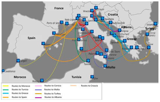
Figure 1.
Roll on-roll off (Ro-Ro) International routes in the Mediterranean Sea [8].
The absence of some maritime relationships (for example between the states of the northern shores of the Mediterranean and Arab countries such as Egypt, Israel, and Syria) is partly explained by the poor coherence of transport demand, in part by the lower competitiveness of direct maritime relations of Ro-Ro with regard to maritime container transport and road transport. However, the high transit times that characterize container transport and the high cost of road transport do not facilitate the growth of trade and therefore of the respective markets. If the exchanges between the Italian and Arab countries are taken as an example, it is possible to observe that the full container maritime services offer boarding from the Adriatic and Tyrrhenian ports on a weekly and/or fortnightly basis, but due to the intermediate stops port to port, travel times vary from 7 to 13 days. Meanwhile, truck services have a much higher cost than maritime services and are therefore hardly sustainable for the transport of consumer goods.
In this regard, a study [9] relating to the competitiveness of short sea shipping (SSS) corridors and road transport, by comparing the costs of moving food products (olive oil) from Spain to several Italian ports, shows that the transportation cost for the road alternative is about 35% higher than the SSS.
It should also be noted that most of the Mediterranean Ro-Ro and Ro-Pax (freight and passengers) routes (both on the western and eastern sides) climb Italy, consolidating the gaps in the TEN-T (Trans European Transport Network) corridors (Figure 2); this applies to the west-east corridor, along the bridge-Balkans Barcelona–Italy; to the double Adriatic corridor that connects Italy with Greece (Trieste, Venice, Ancona, Bari, and Brindisi all have a historical link with Igoumenitsa–Patras) and Turkey and fall within the countries of the Middle East; to the Tyrrhenian connections with the North African countries; and to the connections between Italy, Malta, Corsica, and Albania (the Bari-Durres line is historical).
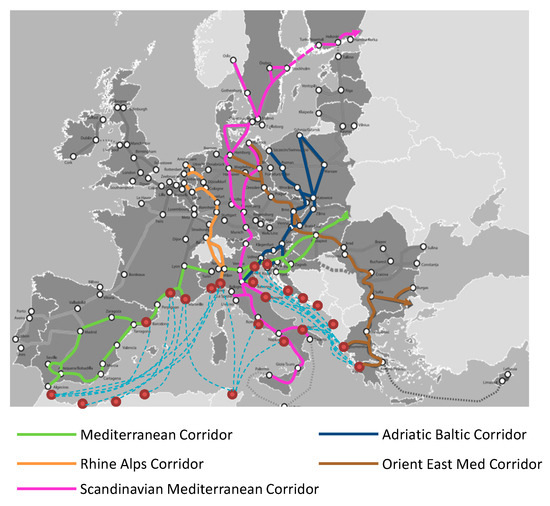
Figure 2.
Integration among Ro-Ro lines and TEN-T Corridors.
Table 1 shows some features of the main currently operating Ro-Ro lines that allow the connection between the southern and northern shores of the Mediterranean.

Table 1.
Some Ro-Ro lines in the Mediterranean.
In the last 20 years, the traffic of Ro-Ro ships in the Mediterranean has exceeded 4 million units, with a growth of 255%, which has led to freight transported by ferry reaching the same level as freight moved with containers. In 2017, 70,000 Ro-Ro vessel positions in the Mediterranean were detected, with an increase of 7.4% compared to 2012 [10]. According to some recent studies in the Euro-Med area, Ro-Ro traffic moves over 84 million tons of goods, of which around 30 million is SSS. In 2015, approximately 14.9 million tons of goods were exchanged between Italian ports in the Adriatic and ports in the Balkans and the eastern Mediterranean using Ro-Ro maritime transport, and about 15 million tons of goods were exchanged between the Tyrrhenian Italian ports and Maghreb and Western Mediterranean ports [8].
At the geo-economic level, the Mediterranean interfaces the Atlantic and North European markets on the one hand and the Asian and African markets on the other. For this reason, the centrality of the basin in an international context is a strong factor of attractiveness for public and private investments in the transport and logistics fields, which continue to grow despite some critical social and political situations. The Mediterranean is a privileged transit route for containerized traffic, but it is also a very significant area for short-distance Ro-Ro traffic, particularly in the North-South direction. This situation determines new market needs that require, not only transport services, but also integrated logistics services that presuppose the existence and functionality of an intermodal network system capable of projecting the Mediterranean basin regions at the center of Europe. In particular, the market requires integrated services that also include processes of freight handling and transformation, to generate added value and minimizing monetary costs and logistic times.
Hence the hypothesis of a hub and spoke network structure to realize an integration between the TEN-T networks and the Ro-Ro sea routes coming from the southern and eastern shores of the Mediterranean in order to produce significant economies both for transport operators and users.
3. A Hub and Spoke Network to Produce Economies
The spatial efficiency of a transport network, deriving from its configuration and structure, involves the consideration of economies of scale, economies of density, and economies of purpose [11]. Economies of scale derive from the expansion of traffic and the size of the network (reduction of average costs due to the increase in traffic volumes and network size); density economies derive from the expansion of traffic with a constant network size (greater exploitation of existing capacity); finally, economies of scope (better fleet rotation and/or greater average load factor) refer to the impact on average costs by the addition of new services within a single dimension of network space [12]. The structure of a transport network, therefore, represents an important endogenous variable of spatial efficiency that determines the process of minimizing costs together with the structure and sequence of connections, the capacity offered, the type of logistic and intermodal services, and the possibility of integration and cooperation between the stakeholders in the supply chain for door-to-door services.
The hub and spoke (H&S) model allows a reduction of the average cost due to the economies of density on the single links. The presence of these economies and the possibility of adding new connections to the network structure, achieving economies of scope, makes it convenient to adopt a H&S structure [13] as has been demonstrated in air transport.
The term H&S means a network scheme in which there is a central node (hub) where most of the displacements are concentrated, connected to a set of peripheral nodes through a set of rays (spokes). This model has considerable advantages over a solution with point to point (P2P) connections between all the nodes of the network. For example, if it is necessary to connect six different nodes, the total number of P2P connections would be equal to 42 (Figure 3a); with an H&S approach, in which an intermediate hub node is appropriately inserted, the number of connections would drop to six (Figure 3b). In general, N is the number of the connected nodes and the number of links is N·(N-1)/2 for a P2P network, but only (N-1) for a H&S network.
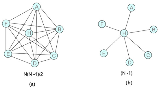
Figure 3.
Network schemes: (a) Point to Point (P2P) Network; (b) Hub and Spoke (H&S) Network.
It follows that, with the same flow and if the traffic between two nodes is conveyed through a hub, a greater saturation of the intermediate sections is possible. Therefore, if it were not economically convenient (due to the reduced flows) to connect two nodes (A and B) of the network directly, the transit from a hub could make it possible to realize a connection (even if indirect) by exploiting the greater flows to/from the hub itself. Moreover, if a support hub is used, the greater saturation of the sections to/from the central node allows, in the unit of time, a greater frequency of connections to/from the hub itself and therefore also between two “peripheral” nodes. Compared to a direct (feasible) trip, the main disadvantage is the longer travel time caused by the greater distance traveled between node A to node B, passing thought the hub (AH + HB > AB).
The H&S system offers the opportunity to exploit the economies induced by the concentration of flows at a transshipment point, but it naturally requires an efficient organization of degroupage, storage, and groupage services, so as to facilitate the operations of sorting and distribution.
The choice of hub nodes must be made according to the economic and temporal profile of the territories that can be served using land and sea feeder links. The presence of a hub in a specific geographical area has a synergistic and non-competitive function with the other regional freight nodes. The requirements that a hub node should have are:
- Strategic position;
- Rapid handling times of goods (turn-around);
- High level of service characterized by efficiency, productivity, and competitive costs;
- Frequent, fast, and efficient land (road and rail) and maritime connections that allow the expansion of the area of influence of the node;
- Added value of logistics activities;
- Use of advanced technologies for the management of information and physical flows.
Given its peculiarities and its strengths, the H&S model is proposed, with appropriate specifications, for the modeling of Euro-Mediterranean freight transport networks where an equipped logistics system in a central region of the Mediterranean is assumed as the hub. The proposed model is oriented to obtain economies related to the configuration of an intermodal sea-rail network with a hub in Calabria on which the connections, coming from the southern shore of the Mediterranean and/or from Eastern Europe, stand and spokes services (rail or sea) allow the connection with Central and Western Europe (Figure 4). The figure shows, through chromatism, the decomposition and re-composition of the goods loads by destination.
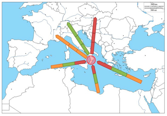
Figure 4.
H&S system for Mediterranean area.
Calabria, in the heart of the Mediterranean basin, is a region equipped with ports of great and medium capacity (Gioia Tauro, Vibo Valentia, Crotone, Corigliano) that are able to assume the connotations of an integrated European logistics platform projected on both the Adriatic–Ionian corridor and the Tyrrhenian corridor. The ongoing upgrade of the Italian rail transport network along the Ionian-Adriatic route, with the Southern terminal in the port of Gioia Tauro (railway C line with transit capacity for 750 m trains), with services structured to link in sequence the four ports, prefigures a reliable, efficient, and effective option of spokes towards Central Europe that could be very advantageous compared to direct transport by sea in terms of costs and travel times.
4. Impact Analysis for a H&S Network. Methodological Approach
The methodological approach for the evaluation of the impacts deriving from a reorganization of maritime services from a P2P configuration to an H&S structure is a simulative approach (What if); however, some analyzes are also underway through the optimization approach (What to).
A macroscopic and stochastic simulation model was used. Figure 5 schematizes the methodological approach followed in the research.
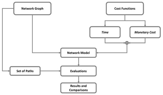
Figure 5.
Methodological approach.
It provides for the schematization of maritime connections by means of a graph. The graph G = (N,L) is defined by identifying the set of nodes, N, and the set of links, L (consisting of nodes pairs belonging to N). The nodes represent the maritime ports where Ro-Ro lines have an origin/destination. The nodes are characterized by times and costs related to freight handling and to the stop in port. The links, instead, represent a phase of connection that is the distance covered on maritime routes and/or activities related to the displacement; in any case, the crossing of the link is characterized by travel times and costs. The network model is obtained through the association of specific cost functions to nodes and links.
The assessment of path costs can be realized in terms of generalized transport cost or by considering the separately non-homogeneous cost components (time and monetary cost). In the first case, it is possible to have a summary indicator, which is very useful in the comparison of different alternatives. In the second case, instead, the interpretation of phenomena by stakeholders are simplified; in fact, they consider time or monetary cost in relation to the delivery and the freight type. The paths are generated with reference of graph and the related evaluation are realized in terms of:
- Network length or distance (L) traveled;
- Service frequency (q);
- Number of ships necessary to guarantee services (nS);
- Miles traveled in a week (Mw);
- Capacity offered by services, given the network configuration (NC);
- Monetary cost for a Ro-Ro shipping operator (CSO).
The frequency of the service (q) on the single connection can be evaluated in relation to the time taken to complete a trip (tv):
where tS is the travel time by sea, tp_O and tp_D are, respectively, the time spent at the port of origin and the port of destination for the exit/entry from/to the port of the ship and for loading/unloading operations, and tr is the time for the ship re-equipment for a new journey and the re-alignment of the departure times. Starting from the time required to complete a journey expressed in days, it is possible to evaluate the number of trips that can be made in a week:
tv = ts + t(p_O) + t(p_D) + tr,
q = 7/(2 · tv).
The miles traveled on the network in a week (Mw) to carry out the services are evaluated as:
where Mwi are the miles traveled in a week along the link, i, qi is the frequency of the service related to the link, i, and Li is the maritime distance between the ports connected by the link, i.
Mw = ∑i Mwi = ∑i qi · Li,
The line capacity offered by the network is given by:
where NCi is the line capacity offered on link i; qi is the frequency of the service related to the link, i, and SCi is the capacity of the ship used on link i.
NC = ∑i NCi = ∑i qi · SCi.
The evaluation of the monetary cost (CSO) incurred by the Ro-Ro shipping operator is carried out with an aggregate model:
where L (sea miles) is the distance by sea and cu (€/mile) is the unitary cost that can be evaluated as the ratio between the annual cost (Cyear) of the service on the route and the miles annually traveled on the same route (Lyear):
CSO = cu ∙ L,
cu = Cyear/Lyear.
In particular, Lyear is evaluated by using the following formula:
with nw being the number of weeks of annual navigation, nf being the number of trips per week, and Lp being the port-to-port distance expressed in nautical miles.
Lyear = nw ∙ nf ∙ Lp,
The Cyear cost is expressed according to the meters-miles (MM) produced by the ship in a year as:
where:
where T is the average number of transported trailers on a trip and lT is the average length of the trailer.
Cyear = cyear ∙ MM,
MM = Lyear ∙ T ∙ lT,
The annual unit cost (cyear) is a function of numerous factors such as the ship’s amortization and interest (cd), insurance costs (cin), fuel and lubricant consumption (cf-l), ordinary and extraordinary maintenance (cm), crew costs (cc), and fees related to the port such as pilotage, mooring, ground staff, loading/unloading charge, and agency general costs (cp):
cyear = cd + cin + cf-l + cm + cc + cp.
Table 2 shows the formulas for the evaluation of each cost components. The need to report annual costs to the MM arises from the heterogeneity of the parameters that come into play in determining the annual cost for the shipping operator.
Table 2.
Operating costs composing the annual unitary cost, cyear.
For the determination of the unit transport cost, in the perspective of a Ro-Ro shipping operator, the following assumptions were made:
- Characteristics of the ships shown in Table 3 (two different kind of ship);
Table 3. Ships characteristics.
- Loading of the ship equal to 60% of the capacity;
- Average journey distance of 800 nautical miles;
- Service frequency equal to three routes per week;
- Operational transport service for 48 weeks/year;
- Unit costs incurred at the ports of origin and destination (pilotage, mooring, loading/unloading, agency fees), according to Table 4.
Table 4. Unitary costs at ports.
5. Application to Test Network and Results Discussion
An application is proposed on a simplified test network (Figure 6), in order to highlight the potential advantages of a structural change in the network with the transition from a diffuse P2P network to a H&S network.
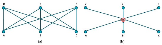
Figure 6.
Test network: (a) P2P Configuration; (b) H&S Configuration.
It is assumed that ports A, B, and C are located on the southern shore of the Mediterranean Sea (Algeria, Tunisia, and Egypt), while ports D, E, and F are on the northern shore (France, Italy, and Greece). In the H&S network configuration, the hub (H) was considered in a barycentric position (Calabria region). In the first case, the network consists of six nodes and nine links, while in the second case the number of nodes is equal to seven and the number of links is reduced to six.
Distance matrices, assumed in the analysis for both network configurations, are shown in Figure 7.
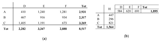
Figure 7.
Distances matrices (miles): (a) P2P configuration; (b) H&B configuration.
The adoption of an H&S configuration allows a considerable reduction (−146%) of the distances to be covered for connections between the considered ports: 8517 miles in the P2P case: 3459 in the H&S case.
Table 5 shows the frequencies obtained for carrying out transport services in the case of a P2P network configuration. To guarantee these frequencies, nine ships are necessary (1 per link).
Table 5.
Matrix of service frequency (trips/week) in P2P network configuration.
The frequencies recorded in the case of a H&S configuration are shown in Table 6. To guarantee the service, six ships are required.
Table 6.
Service frequency (Trips/week) in H&S network configuration.
Given these frequencies, it is observed that in the case of a P2P network, about 22,655 miles are traveled in a week compared to the 13,736 traveled in the case of an H&S configuration, with a reduction of 65%.
The capacity of the system in terms of transported trailers per week is almost unchanged between the two network configurations. The costs incurred by the shipping operator are instead reduced by 65% when moving from the P2P network to the H&S network. The fleet has reduced by a third (six ships instead of nine ships).
Table 7 shows a summary that allows comparison between the two examined network configurations.
Table 7.
Summary framework for network comparison.
To make the service more attractive in the case of a H&S network configuration from the perspective of a multimodal transport operator (MTO), it is possible to use a number of ships equal to those used in the case of a P2P network (i.e., nine ships), thus ensuring a greater frequency of service on some links (in this case, the longer ones). Even in this case, good results can be obtained in terms of miles/week traveled and costs for the shipping operator (Table 8) obtaining advantages also for an MTO or services with higher frequency and an increase in transport capacity.
Table 8.
P2P and H&S comparison.
The results obtained on the test network show an effective convenience in the adoption of a H&S network configuration. However, it is of benefit to observe that a real change implies a specific agreement among the existing shipping operators or the monopoly of the maritime services. The reduction in traveled distance can give significant energy and pollution savings, as well as increasing general safety.
A further analysis was carried out with reference to the current status considering some of the maritime connections operating between the southern and northern shores of the Mediterranean (Figure 8), assuming an H&S network as the scenario configuration.
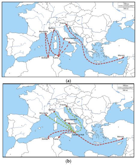
Figure 8.
Ro-Ro network: (a) Current configuration; Current Status—P2P connections; (b) Scenario Configuration; Scenario—H&S Configuration.
Table 9 summarizes the obtained results. The transition to a H&S network configuration leads to a 0.75% increase in the distances to travel and 10% in the miles travelled in a week. The H&S configuration also allows an increase in frequency (+28%) and transport capacity (+28%) against the use of eight ships against the five currently in use on the current status. There is also an increase in costs (+10%) for Ro-Ro shipping operators.
Table 9.
Comparison between P2P network (Current Status) and H&S (Scenario).
It should be noted that the transition to the scenario configuration allows a considerable increase in frequencies, guaranteeing a rapid service and the strengthening of the transport supply.
6. Conclusions
The configuration of the H&S network improves the cost/service ratio and allows the reduction of efficiency losses related to P2P transport due to poor reliability, high costs and times, low frequency, restricted space penetration, unbalanced traffic by direction, and low utilization of the maritime Ro-Ro lines. A system with hub nodes (logistic/intermodal terminals) and feeder connections (by road, by rail, and by sea) offered in terms of unique contractual/transport tariffs can determine a higher average utilization coefficient of the network, a higher frequency of services, a greater spatial extension through the increase in the number of achievable destinations, and a more efficient use of transport units and loading units. The paper proposes the results of the first phase of research, in which the point of view of the Ro-Ro shipping operator has been examined and only maritime-type spoke connections have been considered.
The research foresees different future developments:
- Extension on a large real context;
- Analysis of MTO and community point of view;
- Consideration of rail spoke connections to promote intermodality;
- Analysis of H&S systems in term of transport demand impacts;
- Evaluation of efficiency and effectiveness of the hub node (groupage/degroupage operations).
Author Contributions
Short Sea Shipping in the Mediterranean. Potentialities and limits, D.G. and G.C.C.; Hub and Spoke network to produce economies, G.C.C.; Impact analysis for a H&S network. Methodological approach, D.G., G.C.C., and M.M.; Application to test network and results discussion, D.G., G.C.C., and M.M. All authors have read and agreed to the published version of the manuscript.
Funding
This research received no external funding.
Conflicts of Interest
The authors declare no conflict of interest.
References
- DG TREN Project. East Mediterranean Master Plan of the Motorways of the Sea. Deliverable 5.2. 2009. Available online: https://ec.europa.eu/transport/sites/transport/files/modes/maritime/studies/doc/mos/east_med_deliverable5.pdf (accessed on 20 January 2020).
- European Commission. DG mobility and transport. In Analysis of Recent Trends in EU Shipping and Analysis and Policy Support to Improve the Competitiveness of Short Sea Shipping in the EU; Final Report; European Commission DG Mobility and Transport: Brussels, Belgium, 2015. [Google Scholar]
- De Langen, P.W.; Udenio, M.; Fransoo, J.C.; Helminen, R. Port connectivity indices: An application to European RoRo shipping. J. Shipp. Trade 2016, 1, 6. [Google Scholar] [CrossRef]
- Özkan, E.D.; Nas, S.; Güler, N. Capacity analysis of Ro-Ro terminals by using simulation modeling method. Asian J. Shipp. Logist. 2016, 32, 139–147. [Google Scholar] [CrossRef]
- Michaelides, M.P.; Herodotou, H.; Lind, M.; Watson, R.T. Port-2-Port Communication Enhancing Short Sea Shipping Performance: The Case Study of Cyprus and the Eastern Mediterranean. Sustainability 2019, 11, 1912. [Google Scholar] [CrossRef]
- Christodoulou, A.; Woxenius, J. Sustainable Short Sea Shipping. Sustainability 2019, 11, 2847. [Google Scholar] [CrossRef]
- Raza, Z.; Woxenius, J.; Finnsgård, C. Slow Steaming as Part of SECA Compliance Strategies among RoRo and RoPax Shipping Companies. Sustainability 2019, 11, 1435. [Google Scholar] [CrossRef]
- Appetecchia, A. Destabilizzazione dell’area del Mediterraneo e i nuovi scenari del traffico delle merci. In Proceedings of the MercInTreno Conference, Rome, Italy, 6 October 2015. [Google Scholar]
- Galati, A.; Siggia, D.; Crescimanno, M.; Morales-Fusco, P.; Martin, E.; Sauri, S. The Competitiveness of Short Sea Shipping than Road Transport in the Food Sector: The Olive Oil Case in Spain and Italy. J. Marit. Res. 2015, 12, 89–99. [Google Scholar]
- Studi e Ricerche per il Mezzogiorno (SRM). Italian Maritime Economy. In Cina, Corridoi Energetici, Porti e Nuove Rotte: Geo-Mappa di un Mediterraneo che Cambia; Annual Report 2017; Studi e Ricerche per il Mezzogiorno (SRM): Via Toledo, Italy, 2018. [Google Scholar]
- Oum, T.H.; Waters, W.G. A survey of recent developments in transportation cost function research. Logist. Transp. Rev. 1996, 32, 423–463. [Google Scholar]
- Jara-Dìaz, S.R.; Basso, L.J. Transport Cost Functions, Network Expansion and Economies of Scope. Transp. Res. E 2003, 39, 271–288. [Google Scholar] [CrossRef]
- Siviero, L. Economia dei Trasporti Intermodali e Innovazione Logistica, 1st ed.; FrancoAngeli: Milano, Italy, 2005. [Google Scholar]


© 2020 by the authors. Licensee MDPI, Basel, Switzerland. This article is an open access article distributed under the terms and conditions of the Creative Commons Attribution (CC BY) license (http://creativecommons.org/licenses/by/4.0/).