Next Article in Journal
Between Fire and Ice: Experiences of the Persian Fire Festival in a Nordic Setting
Next Article in Special Issue
Situating Indigenous Resilience: Climate Change and Tayal’s “Millet Ark” Action in Taiwan
Previous Article in Journal
Calculating a Drop in Carbon Emissions in the Strait of Gibraltar (Spain) from Domestic Shipping Traffic Caused by the COVID-19 Crisis
Previous Article in Special Issue
Decolonizing Methodologies, Situated Resilience, and Country: Insights from Tayal Country, Taiwan
 
 
Comment published on 5 August 2022, see Sustainability 2022, 14(15), 9632.
Article

Adaptation to Extreme Hydrological Events by Javanese Society through Local Knowledge

1
The United Graduate School of Agricultural Sciences, Gifu University, Gifu 501-1193, Japan
2
Faculty of Applied Biological Sciences, Gifu University, Gifu 501-1193, Japan
3
Faculty of Agriculture, Sebelas Maret University, Kota Surakarta, Jawa Tengah 57126, Indonesia
4
UNION Ltd., Gifu 501-0106, Japan
*
Author to whom correspondence should be addressed.
Sustainability 2020, 12(24), 10373; https://doi.org/10.3390/su122410373
Submission received: 15 November 2020 / Revised: 10 December 2020 / Accepted: 10 December 2020 / Published: 11 December 2020

Abstract

:
Understanding the effects of local knowledge on actions and decisions taken during a crisis is important; empirical studies and scientific data can be instructive to this end. This study integrated local knowledge (Pranata Mangsa) in Jawa, Indonesia, with scientific data on diurnal rainfall, extreme precipitation events, using the Local and Indigenous Knowledge System (LINKS). The results showed that Pranata Mangsa has informed aspects of agriculture including crop calendars, crop patterns, and farming activities, for over 1000 years in Jawa. Pranata Mangsa also enhances community resilience by mitigating the effects of extreme droughts; this finding was validated using scientific data.

1. Introduction

Extreme hydrological events, including drought and floods, occur in various parts of the world [1]. The mechanisms involved are extremely complex and poorly understood [2]. Global warming has affected the hydrological cycle, leading to more frequent and intense precipitation events [3]. Recent studies suggested that future global warming will lead to significant changes in the intensity and frequency of precipitation, which is very likely to be associated with a higher risk of urban drought and floods [4]. Drought can be classified into four categories: meteorological, agricultural, hydrological, and socio-economic drought [5]. There is no universally accepted definition of drought, and no index that applies to all types thereof [6].
The United Nations Environment Programme [7] defines adaptation as follows: “In human systems, the process of adjustment to actual or expected climate and its effects to moderate harm or exploit beneficial opportunities. In natural systems, the process of adjustment to actual climate and its effects; human intervention may facilitate adjustment to expected climate”. Adaptive capacity, community resilience, and strategies adopted in human and natural systems to adjust to uncertainties in the climate should be assessed, along with the frequency and/or severity of climate events [8]. Sensitive systems are needed to ensure survival [9].
Local knowledge can increase the resilience of communities, and enables them to develop adaptation strategies, including early warning systems in the face of an uncertain climate [10,11,12]. Anthropologists and sociologists have developed theories of local knowledge, dating back to the 1930s and 1940s. For example, Redfield introduced the “folk-urban continuum” concept in 1944 [13], according to which risk reduction can only be achieved through a social process as opposed to a technical, engineering-based process [14]. A catastrophic tsunami was predicted by communities in Aceh, Indonesia based on their local knowledge (Smong) [15]. Local knowledge is also being used to prevent and mitigate damaging phenomena linked to climate variability in Zimbabwe, such as flooding [16] and droughts [17]. Many studies have characterized local knowledge as a dynamic and complex body of knowledge, practices, and skills that are developed and preserved by towns or communities through their experiences over time. However, no study has assessed whether local knowledge pertaining to agriculture can enhance community resilience by mitigating the effects of floods and drought.
The Local and Indigenous Knowledge System (LINKS) was proposed by the United Nations Educational, Scientific and Cultural Organization (UNESCO) as a method for integrating local knowledge with scientific studies of disaster risk reduction (DRR) and climate change adaptation (CCA). LINKS has been used to emphasize the relevance and advantages of local knowledge through empirical data. Local knowledge is transmitted from one generation to the next, and may help to mitigate disaster and promote CCA [18].
In Indonesia, local knowledge plays a role in improving disaster preparedness. For example, Smong played a role in the response to the Indian Ocean earthquakes and resulting tsunamis that occurred in 1907 and 2004 [15]. Local agricultural knowledge, including Aneuk Jame (in Aceh), Parhalaan (in Sumatra), Paladang Dayak (in Kalimantan), and Pranata Mangsa (in Jawa) has been used to strengthen community resilience to natural disasters over a long period, and can be traced back to ancient agricultural kingdoms (beginning in 700 AD) [19].
In 1960, the Indonesian government strictly implemented a national program consistent with the Green Revolution, whereby conventional farming was replaced with modern practices (e.g., mechanization, pesticide use, and changes in crop types) [20,21]. Local knowledge was treated as outdated and unscientific by this program, which led to self-sufficiency in rice production by the 1980s. Indonesia was recognized internationally for its favorable policies with respect to the Green Revolution, even being granted the honor of making a speech to other Food and Agriculture Organization (FAO) member countries [22], whereas the local knowledge was regarded only as a traditional culture rather than a practical guideline. However, the new practices were criticized in terms of the high costs, land degradation, and use of unsustainable agricultural practices [23]. Farmer demonstrations also occurred, with one farmer stating: “We were free and able to make our own decisions of what to plant, when to plant, and how to plant based on traditional local knowledge” [24].
The history of local knowledge over the past 1000 years in Indonesia is rich, especially as it pertains to agriculture, which is the focus of this study. Several important questions remain; for example, can an effective agriculture system be achieved based on local knowledge without scientific data; and how does local knowledge relate to DRR and CCA? Hence, we validated and verify the components of local agricultural knowledge, namely Pranata Mangsa, using a scientific approach, and to classify them according to whether they have a scientific basis and can be related to DRR and CCA.

2. Materials and Methods
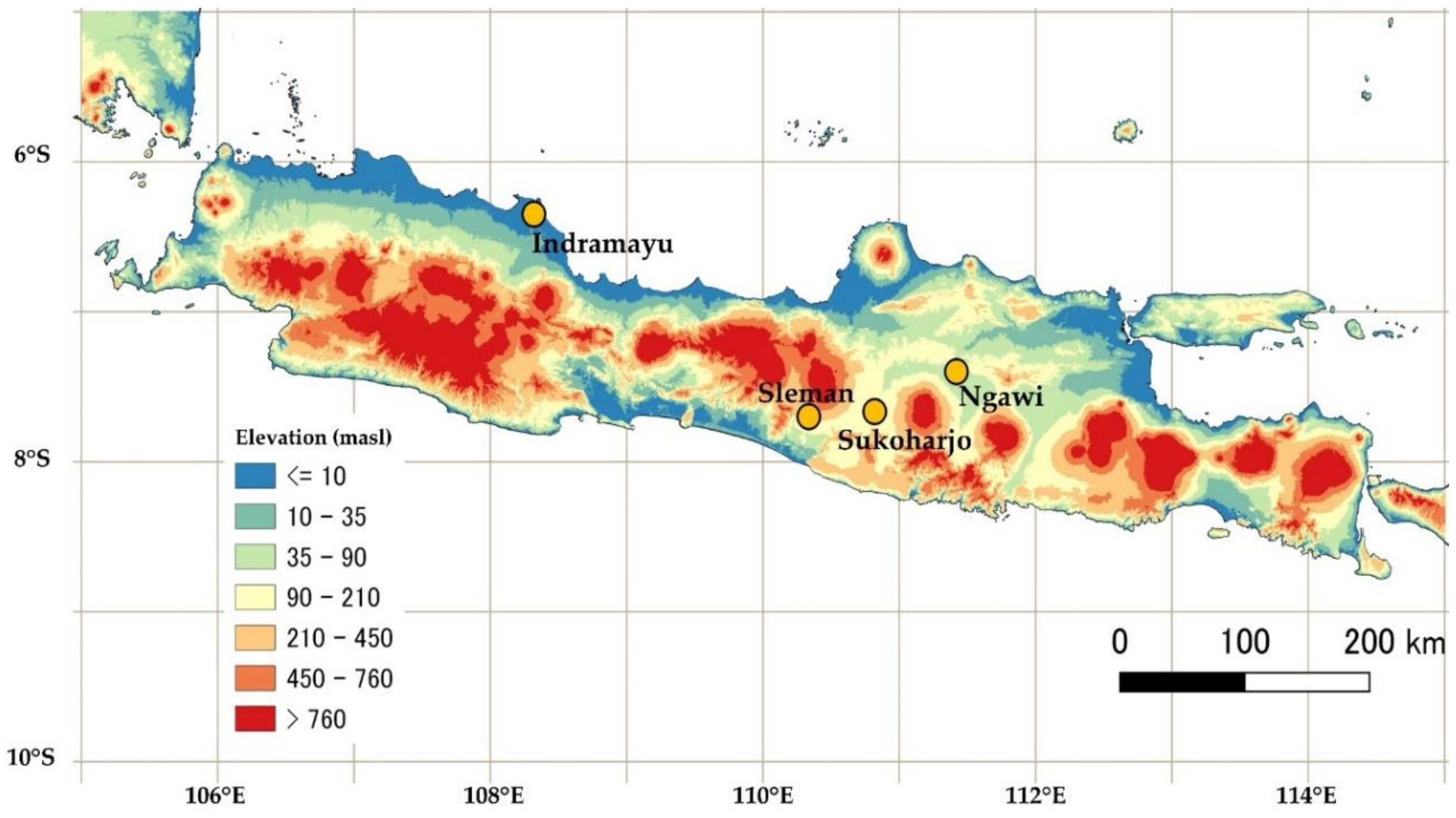
2.1. Study Area

We conducted our research on Jawa island, Indonesia (Figure 1). Jawa has a total population of 150 million and there are three ethnic groups: Betawi, Sundanese, and Javanese. It has an area of ~130,000 km2, which is about 6.8% of the total land area of Indonesia [25]. An original manuscript from Mangkunegaran Palace in Surakarta, Jawa Tengah, Indonesia, was studied as a source of local knowledge. Scientific analyses were conducted in Indramayu (6°21′ S, 108°19′ E; Jawa Barat Province), Sukoharjo (7°40′ S, 110°49′ E; Jawa Tengah Province), Sleman (7°42′ S, 110°20′ E; Yogyakarta Province), and Ngawi (7°24′ S, 111°25′ E; Jawa Timur Province).

2.2. Analysis of Local Knowledge

Pranata Mangsa is written in the Javanese language of Aksara Kromo. Unfortunately, Pranata Mangsa has not been officially translated into other languages, and its applications remain limited. We translated Pranata Mangsa into Bahasa Indonesia, which has been recognized as an official language of Indonesia ever since the country gained independence, on 17 August 1945. We also translated it into English, as one of the official United Nations (UN) languages for international communication.

2.3. Analysis of Scientific Knowledge

Local knowledge was examined by scientific knowledge of the following hydro- meteorological events and systems.
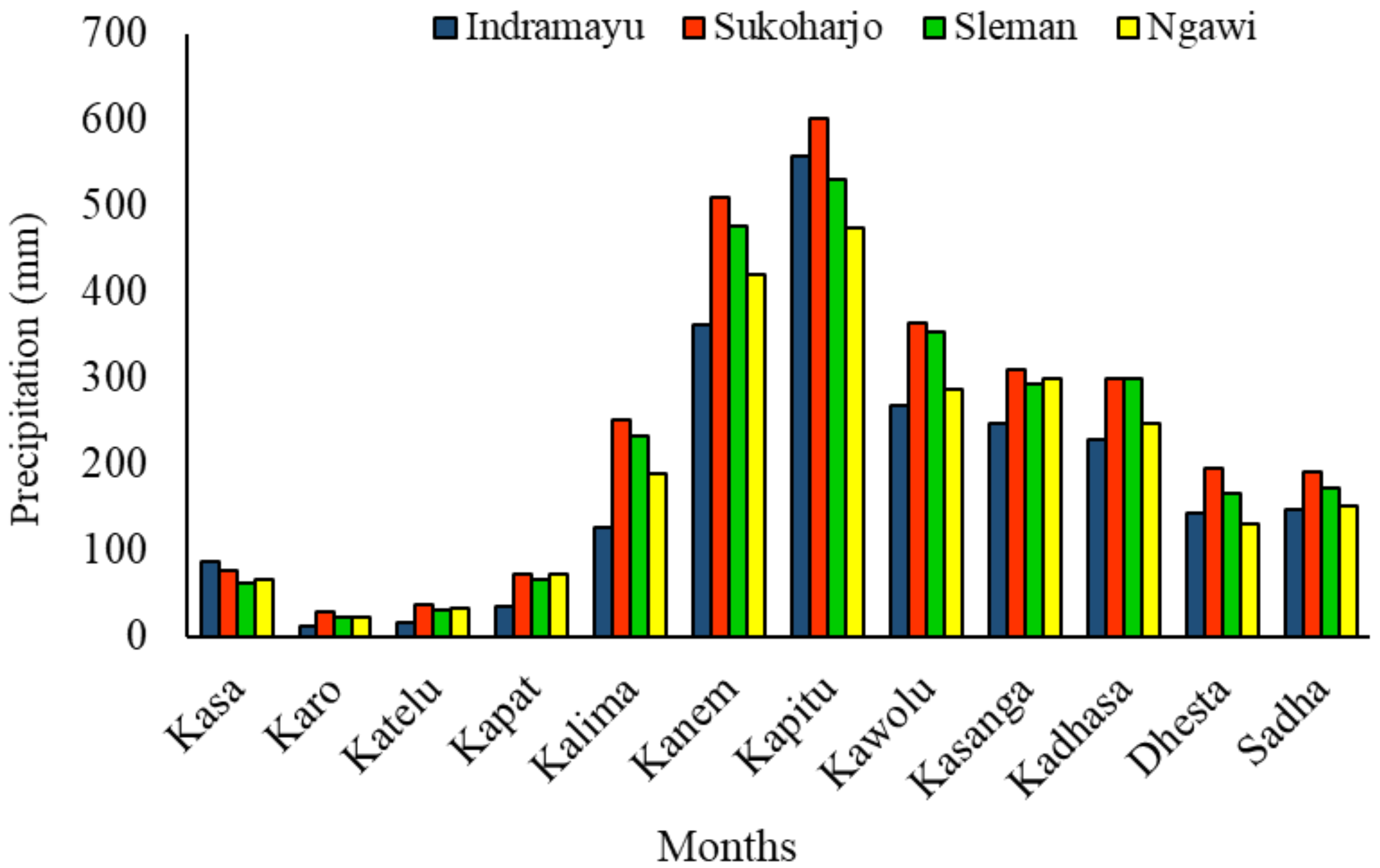
  • Diurnal rainfall. We analyzed Tropical Rainfall Measuring Mission (TRMM) precipitation data, which is collected by the National Aeronautics and Space Administration (NASA) and Japan Aerospace Exploration (JAXA). The TRMM produces global precipitation estimates based on remotely sensed data. The daily 3B42 product (TRMM Multi-Satellite Precipitation Analysis, version 7) used in this study is available at https://giovanni.gsfc.nasa.gov/giovanni. Data for the period 1998–2015 (18 years), with spatial and temporal resolutions of 0.25° and 3 h, respectively, were analyzed.
  • Extreme events. We used the standardized precipitation index (SPI), which employs the gamma function to assess the likelihood of floods and drought based on the probability distribution of long-term precipitation [26]. The SPI is defined as follows:
    S P I = x i x ¯ σ
    where, xi is a specific period (e.g., monthly, annual) rainfall during the year i, x ¯ , and σ are the long term mean and standard deviation in the specific period. Floods and drought were identified using the SPI scale, as shown in Table 1. Positive and negative SPI values indicates that precipitation is above and below average, respectively [27]. We calculated SPI values based on monthly precipitation using the 18 years precipitation of TRMM.
  • Farming system. We consulted previous studies to obtain data on crop patterns, fertilization, and water management.

2.4. Scientific View of Local Knowledge and Adaptation Strategies

The Local and Indigenous Knowledge Systems (LINKS) is a UNESCO interdisciplinary initiative that works: (1) to secure an active and equitable role for local communities in resource management; (2) to strengthen knowledge transmission across and within generations; (3) to explore pathways to balance community-based knowledge with global knowledge in formal and nonformal education; (4) to support the meaningful inclusion of local and indigenous knowledge in biodiversity conservation and management, and climate change assessment and adaptation [18]. We adopted LINKS to examine the components of Pranata Mangsa: crop calendar, crop pattern, and farming system; these domains were classified into four LINKS categories [18].
LINKS Category I: types of local and indigenous knowledge in this category include: (a) observations of celestial bodies (e.g., the moon, sun, and stars), which could help communities predict hazards; (b) environmental observations, such as of the direction and strength of winds; color, formation, and location of clouds; plants; and animal behavior; (c) materials used by local people for disaster mitigation, preparedness, responses, and recovery (e.g., for houses, as well as food eaten during periods of food scarcity); (d) environmental regulations, which play a major role in preventing and mitigating hazards such as coastal erosion, landslides, and floods (e.g., Tara Bandu, practiced in Timor-Leste, which governs social relations and places restrictions on the use of natural resources).
LINKS Category II: this category includes faith-based beliefs, and traditional rituals, legends, and songs. These phenomena cannot be explained in scientific terms, but are practiced by communities to improve resilience and “inner strength”. Thus, it is necessary to maintain these practices across generations. Faith-based beliefs and practices have been reported by many disaster survivors to improve community resilience, strengthen their will, and enable them to move forward. Such comments were made repeatedly by survivors of Typhoon Haiyan/Yolanda, which struck the Philippines in November 2013.
LINKS category III: this category includes local and indigenous knowledge related to climate change and disaster prediction that cannot be understood from a scientific perspective. For example, people in Rapu-rapu island, Philippines, believe that a typhoon will occur when fish keep on moving with no rest, but researchers reported that the sign is not related to meteorological elements and as a behavior of fish for mating or food searching.
LINKS category IV: this category includes beliefs with no scientific basis that cannot be used for weather or disaster prediction. Aneuk jame which is a local knowledge in the coastal area of Aceh, Indonesia, has a belief that a hazard or disaster will occur when dogs howl loudly. This sign has no scientific evidence and is not related to the disaster.

3. Results and Discussion

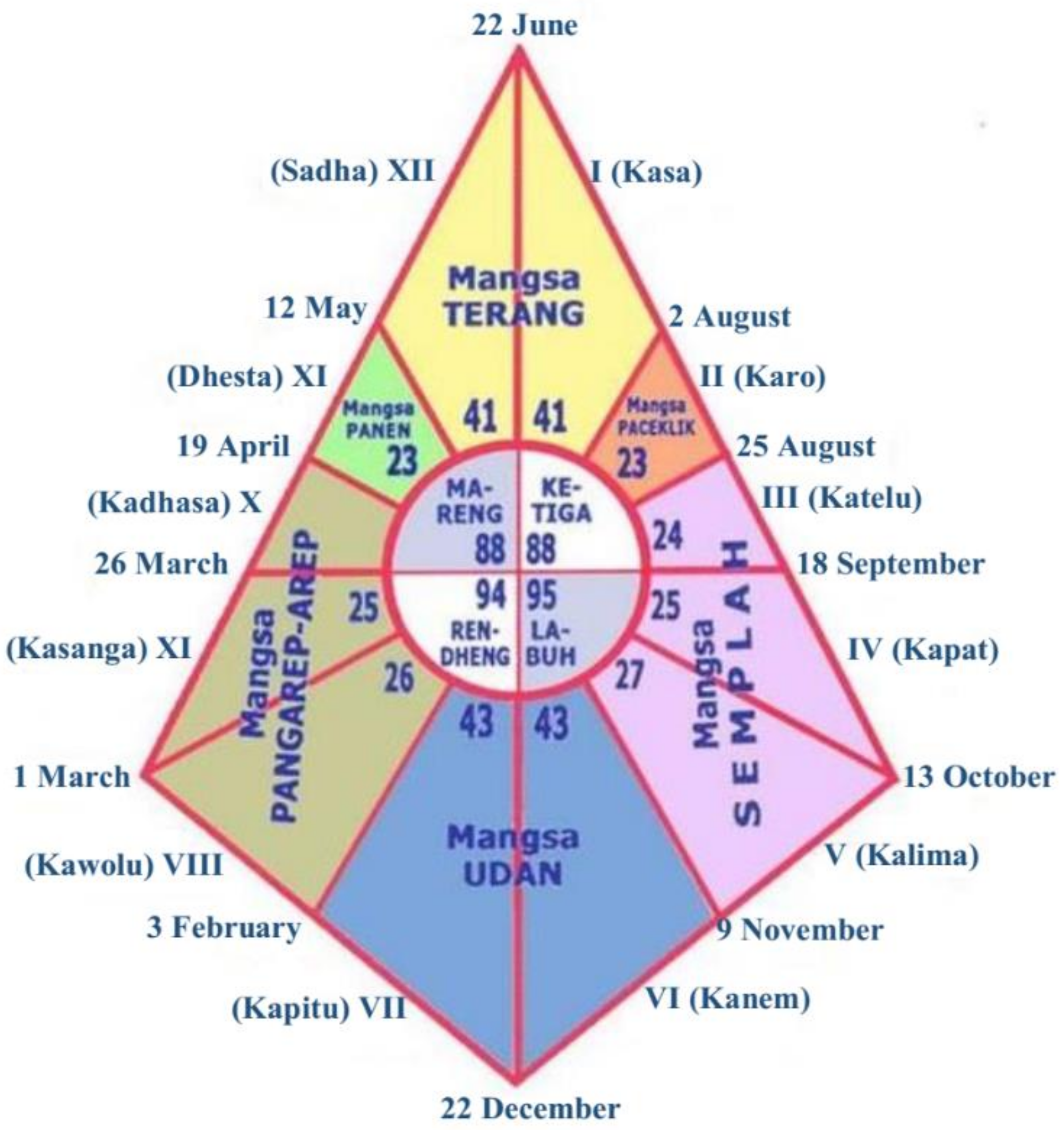
3.1. Pranata Mangsa: An overview

In what we term “the kingdom era”, Javanese society had four social classes: Brahmana (religious leaders), Ksatria (soldiers), Waisya (peasants), and Sudra (businessmen). The peasants were agrarian people who adhered to the “Hamemayu Hayuning Bawana” social philosophy, which focuses on creating a harmonious world through sustainable and environmentally friendly practices [28]. Javanese society in the kingdom era, i.e., from the Majapahit (700 AD) to the Mataram (1855 AD) kingdom, established local knowledge on water management and agricultural systems. King Mpu Sendok (929 AD) proposed the creation of many small farm reservoirs around the Brantas River (320 km length) in Jawa Timur and Bengawan River (600 km length) in Jawa Tengah [19]. On 22 June 1855, King Sri Susuhunan Pakubuwono VII introduced the practice of using Pranata Mangsa as a crop calendar, and as a basis for organizing agricultural activities. The words Pranata and Mangsa mean rule and season, respectively
The crop calendar starts around the summer solstice (on 22 June). On initial inspection, Pranata Mangsa appears very complicated and confusing because the number of days in each month varies from 23 to 43, as shown in Figure 2; this shape is based on the library of Mangkunegaran palace, which visualizes the Pranata Mangsa calendar. However, more careful examination revealed that the calendar is based on local cosmology. Pranata Mangsa has 12 months: Kasa, Karo, Katelu, Kapat, Kalima, Kanem, Kapitu, Kawolu, Kasanga, Kadhasa, Sadha, and Dhesta. The first 6 months have 41, 23, 24, 25, 27, and 43 days, respectively. The sequence is reversed in the latter 6 months, except for the 8th month, which has 26 rather than 27 days in normal years (Wuntu; it has 27 days in leap years (Wastu)). This local knowledge guides peasants to plan their activities in accordance with the seasonal cycle (Table 2).
Pranata Mangsa has a unique climate classification system: Javanese peasants use Titen to understand the progression of the seasons. Titen refers to the understanding, skills, and philosophies of Javanese peasants, accrued through their long history of interaction with the bioclimate. Together with other environmental factors, the bioclimate is crucial to the existence, growth, reproduction, and distribution of living organisms [29]. The bioclimates of various organisms have been well documented [30]. Based on bioclimatological parameters, Pranata Mangsa distinguishes among four climatic seasons, as follows:
  • Katiga, which is also called the dry season, begins when leaves start to fall (Sesotya murcå ing embanan), the soil becomes cracked (Bantålå rengkå), and bamboo buds appear (Sutå manut ing båpå). Sate sumber is the peak of the dry season. Katiga has a duration of 88 days and occurs during Kasa, Karo, and Katelu.
  • Labuh, which can be translated as “shifting seasons” (dry to rainy), is considered to begin when the bioclimate induces a feeling of “peace in the heart” (Waspå kumembeng jroning kalbu). The arrival of rainfall (Pancuran mas sumawur ing jagad) leads to a “holy feeling” associated with the green color of plants (Råså mulyå kasuciyan). Labuh has a duration of 95 days and occurs during Kapat, Kalima, and Kanem.
  • Rendheng, or rainy season, begins when pests and diseases are carried by the wind (Wiså kéntir ing marutå). Other signs of this season include cats mating (Anjrah jroning kayun) and Garengpung, which is an appealing sound made by a species of Cicadidae (Wedharing wacånå mulyå). Rendheng has a duration of 94 days and occurs during Kapitu, Kawolu, and Kasanga.
  • Mareng, which like Labuh also refers to “shifting seasons” (from rainy to dry), begins during the “animal gestation period” (Gedhong mineb jroning kalbu), which can also be translated as “flowering time” (e.g., for Kapok trees [Sesotyå sinåråwèdi]). Spring water dries up during this period (Tirtå sah saking sasånå). Mareng has a duration of 88 days and occurs during Kadhasa, Dhesta, and Sadha.
Pranata Mangsa informed the organization of the farming system used by Javanese peasants, including crop patterns, irrigation, and field activities. The farming season starts on Kasa (22 June). The crop pattern for a given year is referred to as Berå-Palawija-Paddy, which is described in more detail below.
  • Kasa and Karo are months characterized by paceklik (food scarcity) and a lack of precipitation, which leads to rapid depletion of the water supply provided by small farm reservoirs in rainfed land. Berå means “take a rest”. This concept is applied to the land itself; i.e., no planting activities occur in the fields. The farmer’s activities at this time are as follows: (1) burning rice husk and straw from the previous harvest; and (2) praying to God to make it rain, in a ritual known as Istisqa.
  • Katelu and Kapat correspond to the end of the dry season and the early part of the rainy season, respectively. In these months, Javanese peasants begin to cultivate Palawija, i.e., a secondary crop (e.g., maize, soybean, and peanuts), to alleviate food scarcity.
  • Kalima is a month in which farmers come to the field to pray to God, and express gratitude for any rainfall in a ritual called Seren taun.
  • Kanem to Kadhasa are characterized by rice planting, land preparation, and water and pest management. For water management, the macak–macak system is used, which is characterized by intermittent flooding irrigation. Pest management involves planting refugia plants and placing Sesajen in the field.
  • Dhesta and Sadha are special months for Javanese farmers. These months coincide with harvest time and a ceremony called Gulungan, in which farmers bring their agricultural products to a public area and eat and sing together to express their happiness and gratitude to God.
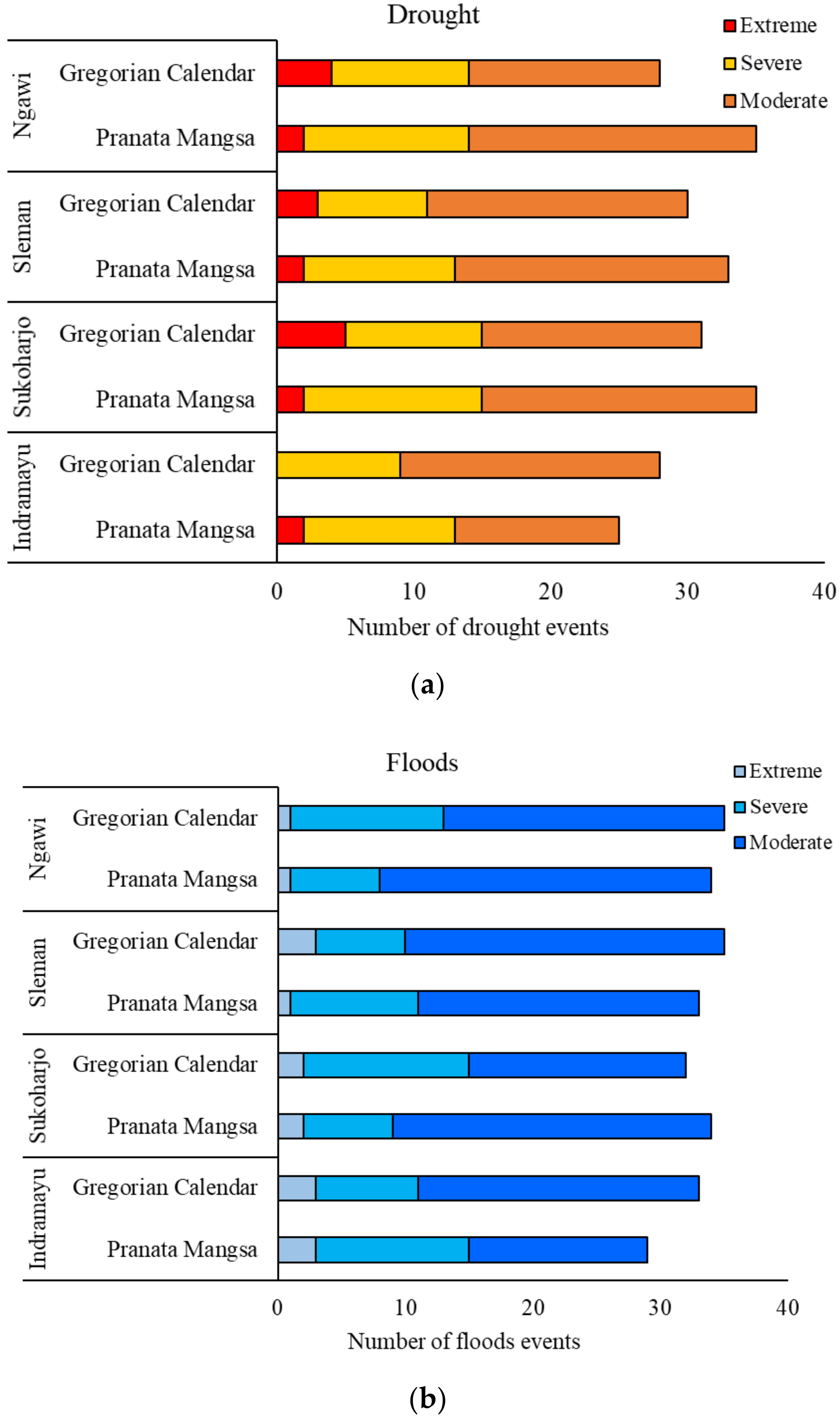
3.2. Extreme Events

Precipitation is a crucial component of the water cycle [31], and is the variable most strongly associated with atmospheric circulation in weather and climate studies [32]. Analysis of rainfall data showed that the total annual precipitation is 2233, 2396, 2702, and 2937 mm year−1 for Indramayu, Ngawi, Sleman, and Sukoharjo, respectively. Figure 3 shows that the average precipitation amount in Kasa, Karo, and Katelu is below 100 mm day−1, with the lowest amount being just 12.63 mm day−1 (in Karo, Indramayu). The highest rainfall amount was recorded in Kapitu, Sukoharjo, at 601.16 mm day−1. Monitoring precipitation is crucial to the well-being of local residents; too much rainfall endangers life and property, while too little causes droughts that negatively impact agriculture and can lead to starvation. Hence, analysis of extreme precipitation events (e.g., drought and floods) is necessary.
The SPI is recommended for assessing drought and floods. It has the following advantages: (i) only a single input variable (precipitation) is necessary, (ii) both wet and dry periods can be analyzed, (iii) analyses can be performed at different time scales, (iv) droughts and floods can be categorized, and (v) the probability-based structure can aid risk management and decision analysis [27]. In this study, the SPI was used at the 1-month time scale to identify drought and floods, informed by Pranata Mangsa and the Gregorian calendar, with the goal of successful adaptation to extreme events. The SPI is an index for extreme events comparing with the average and results in different values depending on the range of the specific period, even if the same precipitation data is adopted. During the observation period (1998–2015) both drought and flood occurred (in 1998 and 2010, respectively). Figure 4 (upper) illustrates the superiority of Pranata Mangsa over the Gregorian calendar for mitigating the effects of extreme drought events in all regions, except Indramayu. However, Pranata Mangsa was not useful for mitigating the effects of extreme floods, except in Sleman, as shown in Figure 4 (bottom). These results suggest that Pranata Mangsa has limitations in the size and location of the community; in line with the term of local knowledge, which is composed of understanding, skills, and philosophies developed by the local society with long histories of interaction with their natural surroundings.

3.3. LINKS: Integrating Local and Scientific Knowledge

Previous studies have documented the effectiveness of LINKS for reframing local knowledge in scientific terms, for example to mitigate the effects of hydro-meteorological disasters in coastal areas. Smong was used in Aceh to strengthen communities following the tsunami disaster in 2004, while Ai lulik and Fatuk lulik were used to predict and prevent landslides in Timor Leste, and Rapu-rapu was used to predict typhoons in the Philippines [15]. However, these studies did not comprehensively explain how local knowledge has been applied in the absence of scientific data, nor how to manage small areas affected by certain kinds of disasters using local knowledge. In this study, we applied LINKS to the agricultural system in Jawa, using Pranata Mangsa as a framework. Thus, local knowledge was used in association with scientific data (e.g., on diurnal rainfall and extreme hydrological events) to adapt to floods and drought conditions.
We found that Pranata Mangsa can be interpreted using LINKS. Our findings confirmed that local knowledge can be integrated with scientific data to increase the resilience of Javanese agricultural communities to floods and drought. Our initial analysis, LINKS I, showed that diurnal rainfall data accorded with the characteristics of, and transition among, seasons. Sate sumber refers to drought, which is concerning for farmers but can be well explained by empirical data. Sate sumber may occur during Kasa, Karo, and Katelu when the precipitation amount is below 50 mm day−1. In response, the Bera-Palawija crop pattern was established in Katiga and Labuh based on Pranata Mangsa, and has reduced crop losses, improved soil quality, and increased soil moisture. In addition, farming activities are scheduled with water management (Macak-macak), soil recovery, and pest management in mind, thus, increasing the number of panicles and paddy yield in Indonesia [23], and reducing water consumption and methane emissions [33]. Also, Berå and the application of burnt rice husk (2 tons ha−1) as an organic amendment can alleviate meteorological and agricultural drought through the “restland” concept. This can allow farmers to adapt to the effects of widely varying precipitation amounts [34], and will improve soil bulk density and porosity [35].
As discussed above, some aspects of Pranata Mangsa cannot be explained by, or integrated with, scientific data, but nevertheless have a significant effect on DRR and CCA (based on our second analysis, LINKS II). Our analysis of local knowledge indicated that rituals and ceremonies promote respect for God and nature among Javanese peasants. As an example, Istisqa is a farming activity practiced when the dry season arrives, based on faith-based beliefs and designed to make communities more resilient. According to our LINK IV analysis, some components of Pranata Mangsa cannot be related to DRR or CCA, including Sesajen, which is the rituals to the God by placing some materials, including myrrh, fruit, and cigarettes at the side of the field for repelling pest or as a pest management. Our results showed that the components of the local knowledge were verified and validated by a scientific data approach, so as to inform policies supporting farming activities, and empower communities to make informed decisions regarding adaptation and DRR.
To our knowledge, this was the first study to investigate the effectiveness of LINKS for integrating local and scientific knowledge of agriculture to mitigate the effects of drought and floods. Our results indicated that Pranata Mangsa can be easily integrated with scientific data, enabling optimal strategies for DRR and CCA to be adopted by scientists, farmers, and policymakers. Although LINKS was successfully used to integrate Pranata Mangsa with scientific data, the applicability of this approach to other knowledge systems in Indonesia should be assessed in future work.

4. Conclusions

Pranata Mangsa is an important system of local agricultural knowledge used in Jawa, and includes information regarding climate conditions, crop patterns, and farming activities. All of these areas can be related to DRR and CCA based on scientific data. Rituals and ceremonies help communities build resilience, but cannot be explained in scientific terms. Such activities will continue to be engaged in by communities.
It is important to recognize that Pranata Mangsa is not wholly effective for DRR and CCA: there are limitations to its utility, depending on: (1) the size and location of the community; (2) the commitment of the participants, especially from the younger generation; and (3) support from stakeholders and policymakers concerned with adaptation to, and mitigation of the negative effects of, extreme hydrological events. In conclusion, this study successfully used LINKS to integrate local and scientific knowledge for flood and drought risk reduction and CCA, which should increase the resilience of communities.

Author Contributions

M.K.Z. (formal analysis, investigation and writing—original draft), K.N. (conceptualization, funding acquisition, supervision and writing—review & editing), K.I. (supervision), K.K. (supervision), S.S. (supervision), M.S. (supervision). All authors have read and agreed to the published version of the manuscript.

Funding

This research was funded by “Advancing Co-design of Integrated Strategies with Adaptation of Climate Change in Thailand (ADAP-T)” supported by The Science and Technology Research Partnership for Sustainable Development (SATREPS), JST-JICA and by KAKENHI Grand No. JP19H03069 and No. JP20J10806.

Acknowledgments

The authors gratefully thank the United Graduate School of Sciences, Gifu University for providing financial support during the Doctoral program of the first author in Japan.

Conflicts of Interest

The authors declare no conflict of interest.

References

  1. Bezdan, J.; Bezdan, A.; Blagojevic, B.; Mesaroš, M.; Pejic, B.; Vraneševic, M.; Pavic, D.; Nikolic-Đoric, E. SPEI-Based approach to agricultural drought monitoring in Vojvodina region. Water 2019, 11, 1481. [Google Scholar] [CrossRef] [Green Version]
  2. Mishra, A.K.; Singh, V.P.; Desai, V.R. Drought characterization: A probabilistic approach. Stoch. Environ. Res. Risk Assess. 2009, 23, 41–55. [Google Scholar] [CrossRef]
  3. Wang, X.; Huang, G.; Liu, J. Projected increases in intensity and frequency of rainfall extremes through a regional climate modelling approach. J. Geophys. Res. Atmos. 2014, 119, 13,271–13,286. [Google Scholar] [CrossRef]
  4. Alfieri, L.; Bisselink, B.; Dottori, F.; Naumann, G.; de Roo, A.; Salamon, P.; Wyser, K.; Feyen, L. Global projections of river flood risk in a warmer world. Earths Future 2017, 5, 171–182. [Google Scholar] [CrossRef]
  5. Wilhite, D.A.; Glantz, M.H. Understanding the Drought Phenomenon: The Role of Definitions. Water Int. 1985, 10, 111–120. [Google Scholar] [CrossRef] [Green Version]
  6. Tirivarombo, S.; Osupile, D.; Eliasson, P. Drought monitoring and analysis: Standardised Precipitation Evapotranspiration Index (SPEI) and Standardised Precipitation Index (SPI). Phys. Chem. Earth 2018, 106, 1–10. [Google Scholar] [CrossRef]
  7. UNEP (The United Nations Environment Programme). The Adaptation Gap Report 2017. UNEP, Nairobi. Available online: https://www.unenvironment.org/resources/report/adaptation-gap-report-2017 (accessed on 14 February 2020).
  8. Etemadi, M.; Karami, E. Organic fig growers’ adaptation and vulnerability to drought. J. Arid. Environ. 2016, 124, 142–149. [Google Scholar] [CrossRef]
  9. Smit, B.; Wandel, J. Adaptation, adaptive capacity and vulnerability. Glob. Environ. Chang. 2006, 16, 282–292. [Google Scholar] [CrossRef]
  10. Andersson, L.; Wilk, J.; Graham, L.P.; Wikner, J.; Mokwatlo, S.; Petja, B. Local early warning systems for drought–Could they add value to nationally disseminated seasonal climate forecasts? Weather Clim. Extremes 2020, 28, 1–12. [Google Scholar] [CrossRef]
  11. Kuruppu, N. Adapting water resources to climate change in Kiribati: The importance of cultural values and meanings. Environ. Sci. Policy 2009, 12, 799–809. [Google Scholar] [CrossRef]
  12. Green, D.; Raygorodetsky, G. Indigenous knowledge of a changing climate. Clim. Chang. J. 2010, 100, 239–242. [Google Scholar] [CrossRef]
  13. Fanslow, G. Prosperity, pollution, and the Green Revolution. Rice Today Bull. 2007, 6, 34–35. [Google Scholar]
  14. Audefroy, J.F.; Sanches, B.N.C. Integrating local knowledge for climate change adaptation in Yucatan, Mexico. Int. J. Sustain. Built Environ. 2017, 6, 228–237. [Google Scholar] [CrossRef]
  15. Hiwasaki, L.; Luna, E.; Shaw, R. Process for integrating local and indigenous knowledge with science for hydro-meteorological disaster risk reduction and climate change adaptation in coastal and small island communities. Int. J. Disaster Risk Reduct. 2014, 10, 15–27. [Google Scholar] [CrossRef] [Green Version]
  16. Mavhura, E.; Manyena, S.B.; Collins, A.E.; Manatsa, D. Indigenous knowledge, coping strategies and resilience to floods in Muzarabani, Zimbabwe. Int. J. Disaster Risk Reduct. 2013, 5, 38–48. [Google Scholar] [CrossRef]
  17. Chisadza, B.; Tumbare, M.J.; Nhapi, I.; Nyabeze, W.R. Useful traditional knowledge indicators for drought forecasting in the Mzingwane Catchment area of Zimbabwe. Disaster Prev. Manag. Int. J. 2013, 22, 312–325. [Google Scholar] [CrossRef]
  18. UNESCO (The United Nations Educational, Scientific and Cultural Organization). Local Knowledge, Global Goals on 2002. Available online: http://www.unesco.org/new/en/naturalsciences/priority-areas/links/related-information/what-is-local-and-indigenous-knowledge/ (accessed on 1 February 2020).
  19. Pigeaud, T.G. Java in 14th century. Cult. Hist. 1960, 1, 1–5. [Google Scholar]
  20. Mears, L. Rice and Food Self-Sufficiency in Indonesia. Bull. Indones. Econ. Stud. 1984, 20, 122–138. [Google Scholar] [CrossRef]
  21. Iizumi, T.; Shiogama, H.; Imada, Y.; Hanasaki, N.; Takikawa, H.; Nishimori, M. Crop production losses associated with anthropogenic climate change for 1981–2010 compared with preindustrial levels. Int. J. Clim. 2018, 38, 5405–5417. [Google Scholar] [CrossRef] [Green Version]
  22. Falcon, W.P.; Timmer, C.P. Food security in Indonesia: Defining the issues. Indones. Food J. 1991, 2, 8–20. [Google Scholar]
  23. Nugroho, W.B. Social construction of green revolution in the “orde baru”. SOCA J. Sos. Èkon. Pertan. 2018, 12, 54–62. [Google Scholar] [CrossRef] [Green Version]
  24. Winarto, Y.T. The evolutionary changes in rice-crop farming: Integrated pest management in Indonesia, Cambodia and Vietnam. Southeast. Asian Stud. 2004, 42, 241–272. [Google Scholar]
  25. BPS (Indonesia Statistic Government Office). Kependudukan. Available online: https://www.bps.go.id (accessed on 25 March 2020).
  26. McKee, T.B.; Doesken, N.J.; Kleist, J. The relationship of drought frequency and duration to time scales. In Proceedings of the 8th Conference on Applied Climatology, Anaheim, CA, USA, 17–22 January 1993; Volume 17, pp. 179–184. [Google Scholar]
  27. WMO (World Meteorological Organization). Standardized Precipitation Index User Guide. Available online: https://data.worldbank.org/indicator/nv.agr.totl.zs (accessed on 25 March 2020).
  28. Wagiran, W. Pengembangan Karakter Berbasis Kearifan Lokal Hamemayu Hayuning Bawana. J. Pendidik. Karakter 2012, 2, 2–5. [Google Scholar] [CrossRef]
  29. Shul’gin, A.M. Bioclimatology as a Scientific Discipline and its Current Objectives. J. Sov. Geogr. 1960, 1, 67–74. [Google Scholar] [CrossRef]
  30. Yoshino, M. Development of Bioclimatological Thought in Japan from Ancient Times to Present. Glob. Environ. Res. 2009, 13, 5–12. [Google Scholar]
  31. Trenberth, K.E.; Dai, A.; Rasmussen, R.M.; Parsons, D.B. The changing character of precipitation. Bull. Am. Meteorol. Soc. 2003, 84, 1205–1217. [Google Scholar] [CrossRef]
  32. Kidd, C.; Huffman, G. Global precipitation measurement. Meteorol. Appl. 2011, 18, 334–353. [Google Scholar] [CrossRef]
  33. Keiser, J.; Utzinger, J.; Singer, B.H. The potential of intermittent irrigation for increasing rice yields, lowering water consumption, reducing methane emissions, and controlling malaria in African rice fields. J. Am. Mosq. Control. Assoc. 2002, 18, 329–340. [Google Scholar]
  34. Nielsen, D.C.; Vigil, M.F. Precipitation storage efficiency during fallow in wheat-fallow systems. Agron. J. 2010, 102, 537–543. [Google Scholar] [CrossRef] [Green Version]
  35. Jeon, W.T.; Seong, K.Y.; Lee, J.K.; Oh, I.S.; Lee, Y.H.; Ok, Y.S. Effects of Green Manure and Carbonized Rice Husk on Soil Properties and Rice Growth. Korean J. Soil Sci. Fert. 2010, 43, 484–489. [Google Scholar]
Figure 1. Map of study area in Jawa island, Indonesia.
Sustainability 12 10373 g001
Figure 2. Pranata Mangsa in the Gregorian calendar. The numbers represent the numbers of days in the seasons and months, respectively.
Sustainability 12 10373 g002
Figure 3. The intensity of precipitation during 1998–2015.
Sustainability 12 10373 g003
Figure 4. The severity levels and number of drought (a) and floods (b).
Sustainability 12 10373 g004
Table 1. The floods and drought classification on standardized precipitation index (SPI) indices.
SPI ValuesClassification
≥2Extremely floods
1.50 to 1.99Severe floods
1.00 to 1.49Moderate floods
−1.00 to −1.49Moderate drought
−1.50 to −1.99Severe drought
<−2Extreme drought
Table 2. Description of the Pranata Mangsa on each Mangsa.
NoMonthsSeasonsTimeseriesBio-Climatological SignsFarmer Activities
1KasaKetiga–Terang22 June–1 August
(41 days)
Leaves fall down; grasshopper goes into the ground; high temperatureBera or fallow land; Time to burn rice straw
2KaroKetiga–Paceklik2–24 August
(23 days)
Kapok tree (Ceiba pentandra) has floweringIstisqa rituals
3KateluKetiga–Semplah25 August–18 September
(24 days)
Bamboo sprouts were growingPalawija planting
4KapatLabuh–Semplah19 September–13 October
(25 days)
Kapok was fruit development, Birds egging or hatchlingsPalawija
5KalimaLabuh–Semplah14 October–9 November
(27 days)
Rainfall comes to the earthPalawija harvesting and Seren Taun ceremony
6KanemLabuh–Udan10 November–22 December
(43 days)
Fruit trees become mature with a small fruitLand preparation on Paddy field
7KapituRendheng–Udan23 December–3 February
(43 days)
High precipitation, and flooding in a riverRice transplanting to the field
8KawoluRendheng–Pangarep-arep4–28/29 February
(26/27 days)
Cats reproduction timeFertigation on paddy vegetative phase
9KasangaRendheng–Pangarep-arep1–25 March
(25 days)
Cicididae has sounded in naturePaddy on reproductive phase
10KadhasaMarèng–Pangarep-arep26 March–18 April
(24 days)
Walang sangit (Leptocorisa oratorius Fabricius.) attack to paddy fieldPaddy on ripening phase
11DhestaMarèng–Panèn19 April–11 May
(23 days)
Kapok fruit has maturePaddy harvesting
12SadhaMarèng–Terang12 May–21 June
(41 days)
GulunganGulungan ceremony
Publisher’s Note: MDPI stays neutral with regard to jurisdictional claims in published maps and institutional affiliations.

