Response of Water Quality to Landscape Patterns in an Urbanized Watershed in Hangzhou, China

Abstract
:1. Introduction
2. Materials and Methods
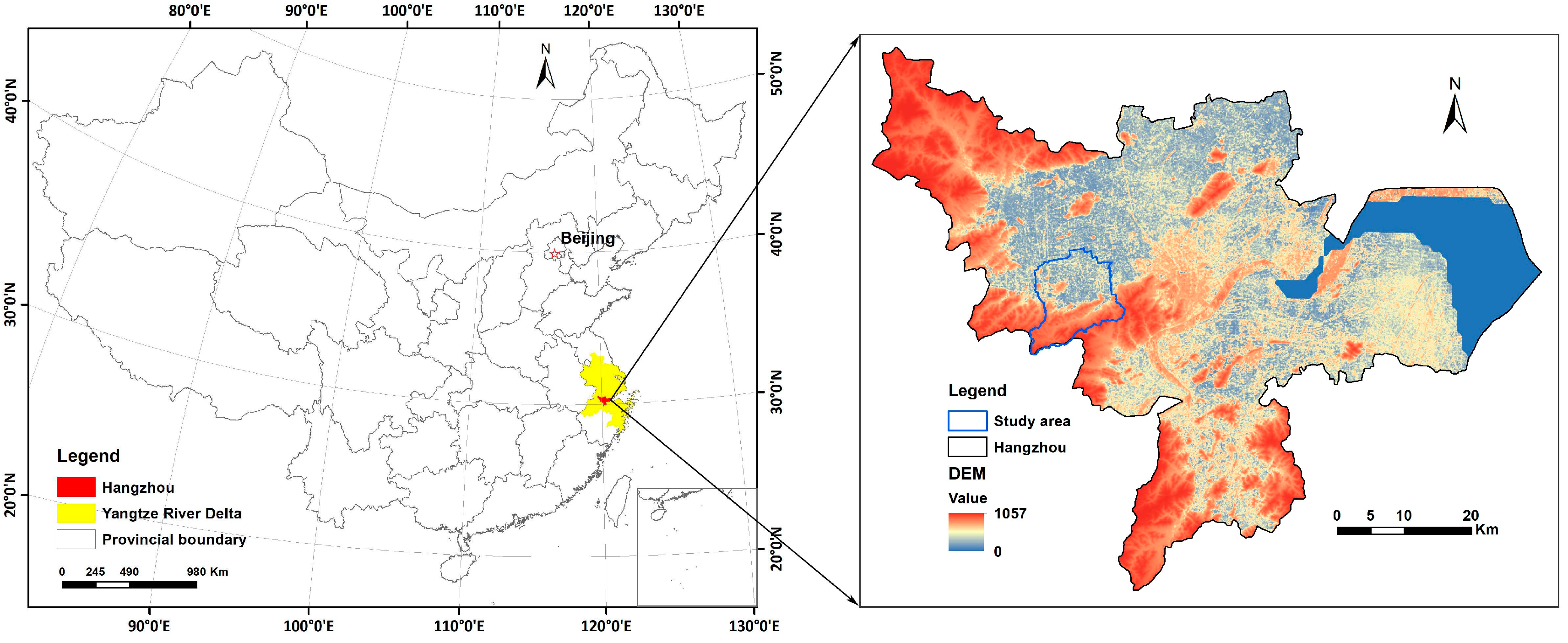
2.1. Study Area
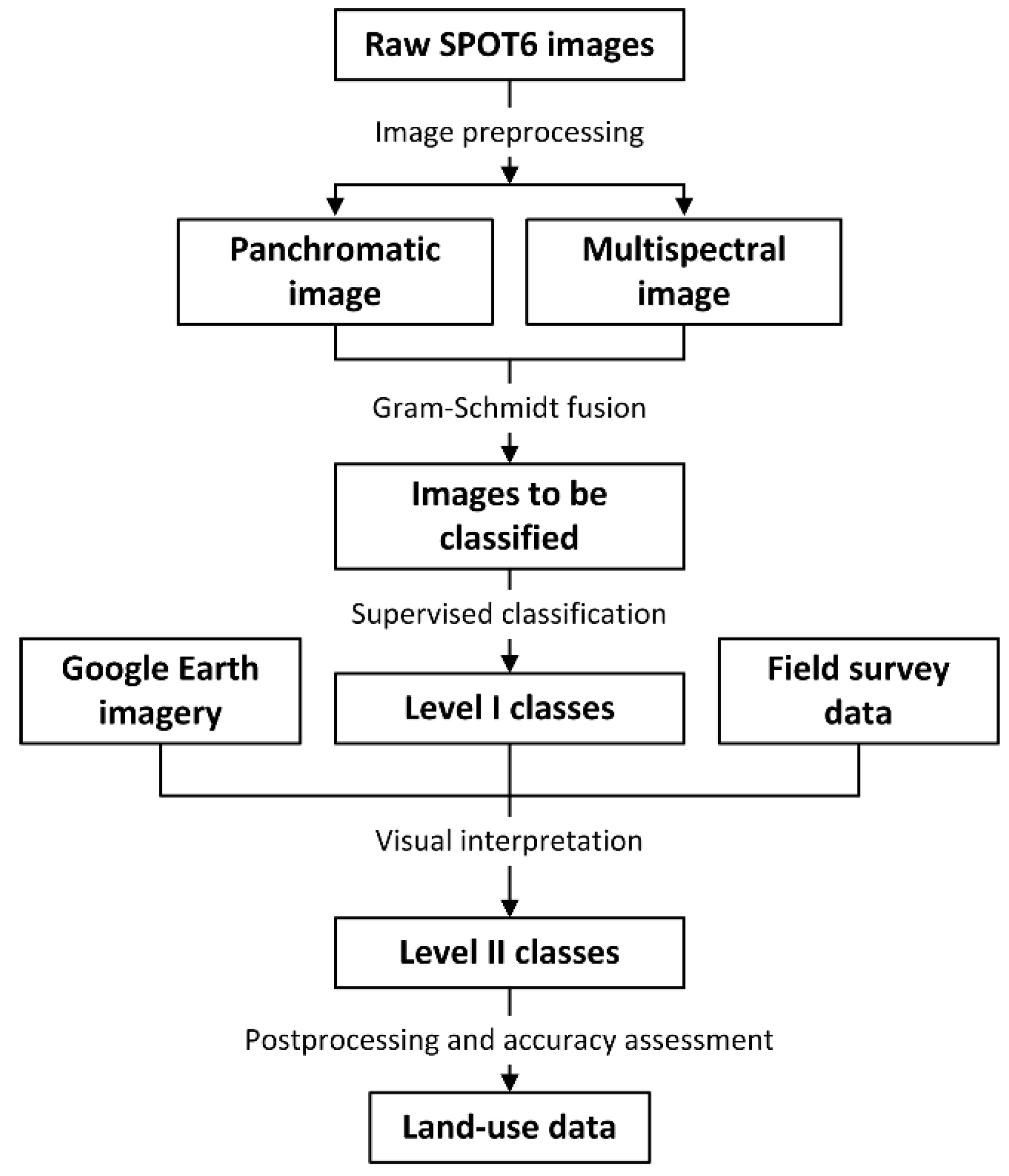
2.2. Land Use Classification
2.3. Watershed Delineation
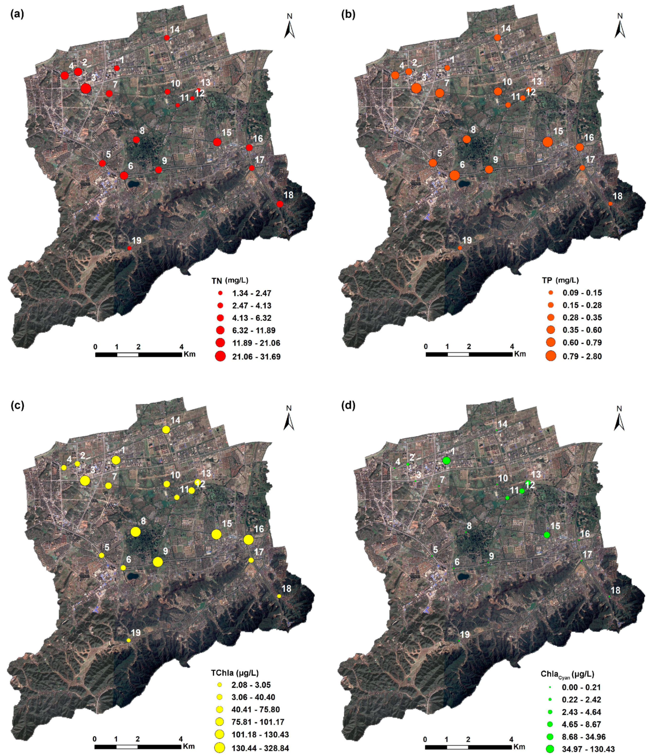
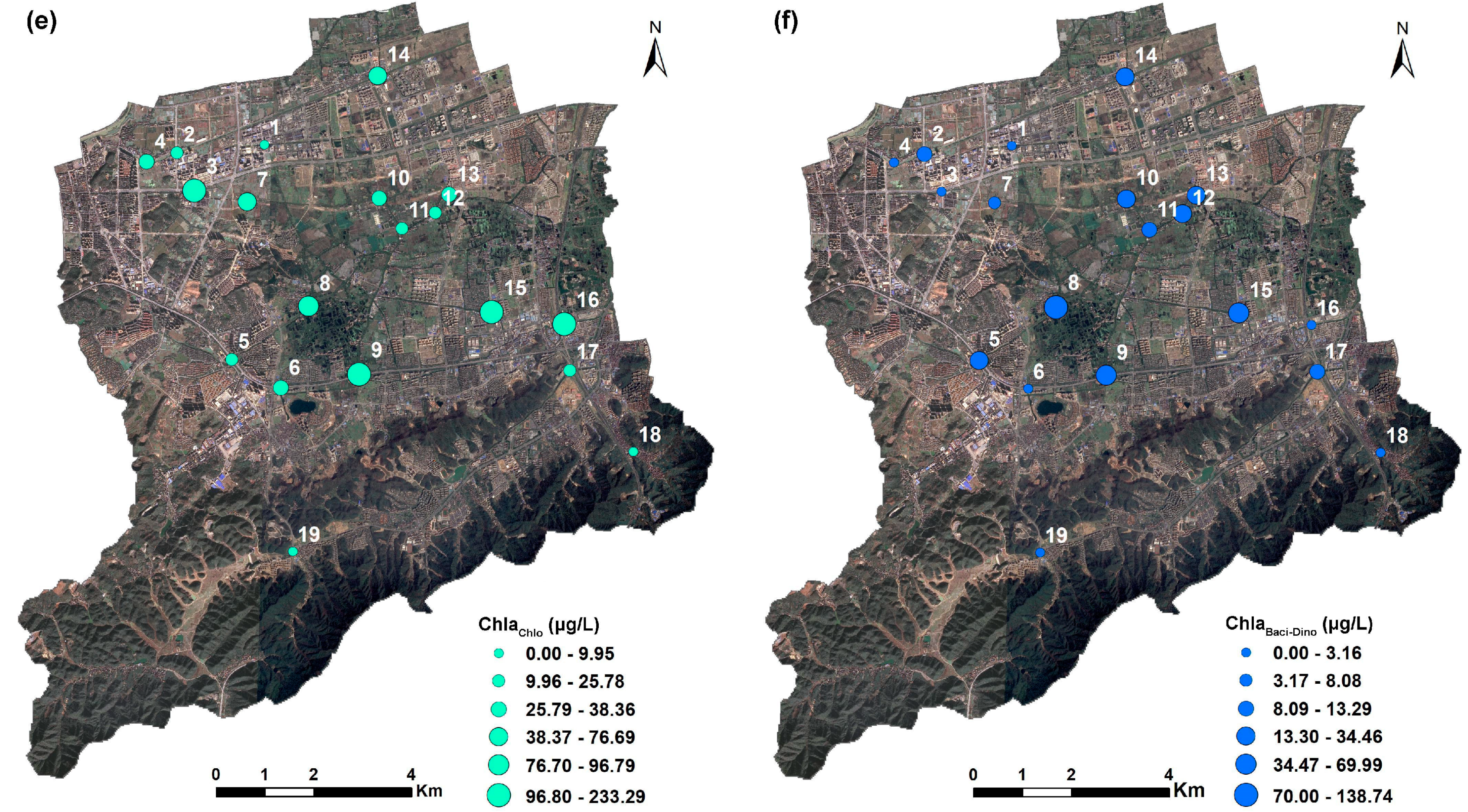
2.4. Water Sampling
2.5. Landscape Metrics
2.6. Statistical Analysis
3. Results
3.1. Land Use Structure and Water Quality
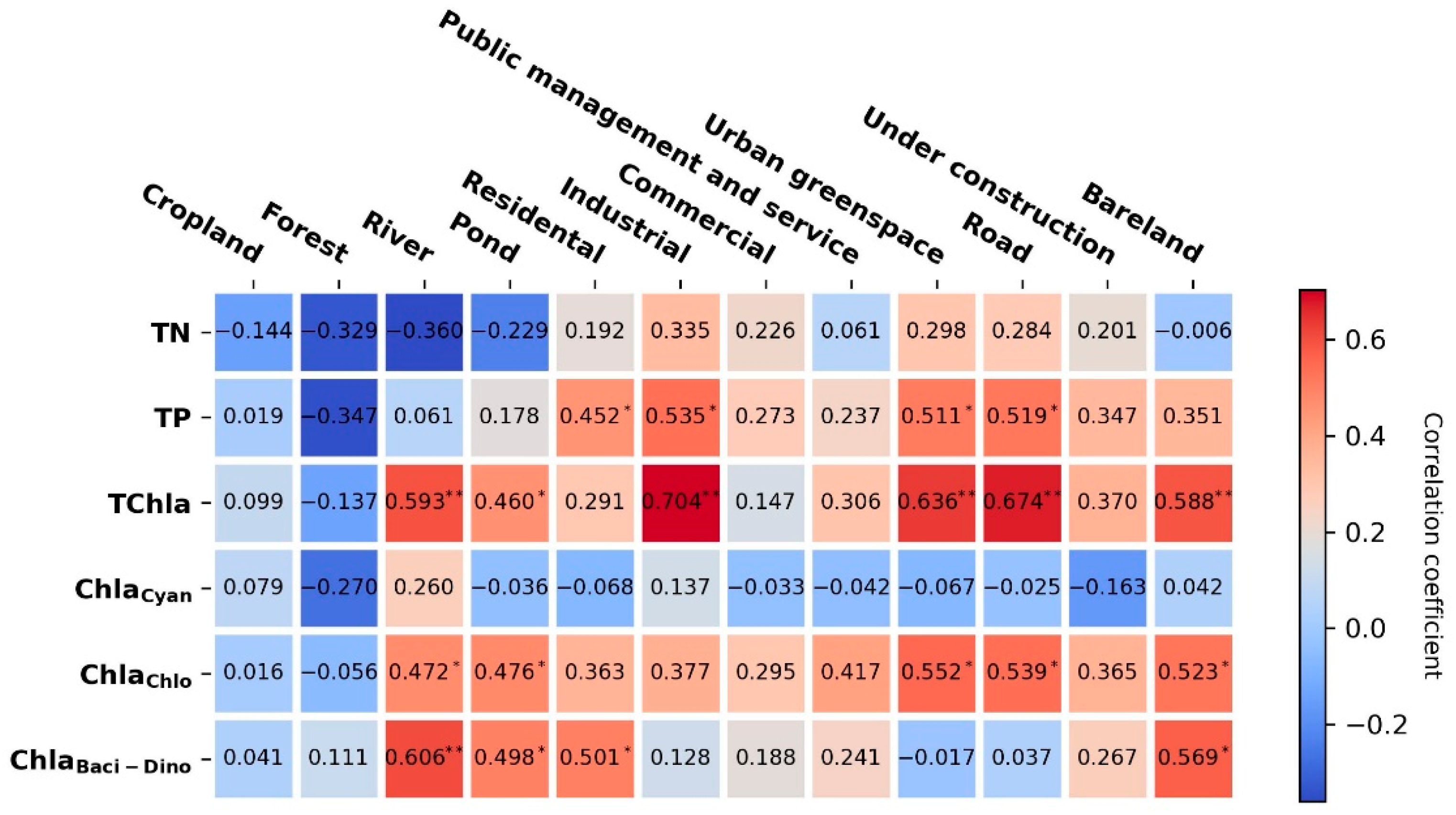
3.2. Relationships Between Land Use Area and Water Quality
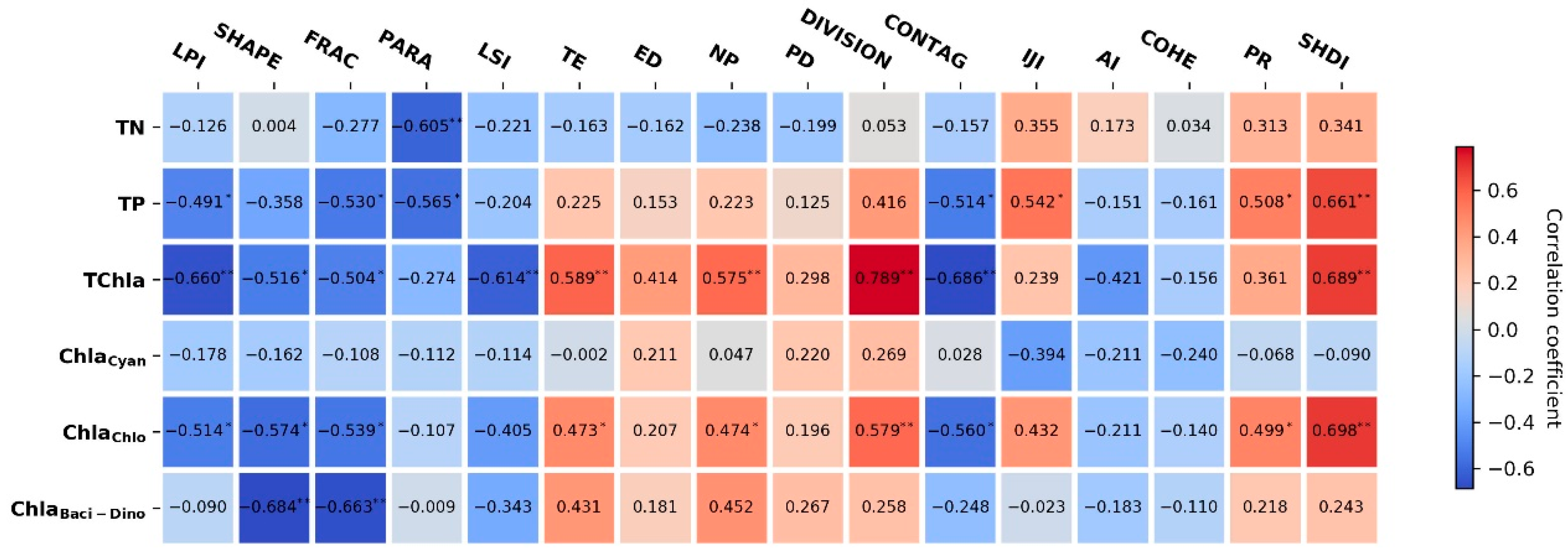
3.3. Relationships Between Landscape Pattern and Water Quality
3.3.1. Land Use Pattern—Water Quality Relationships at Landscape Level
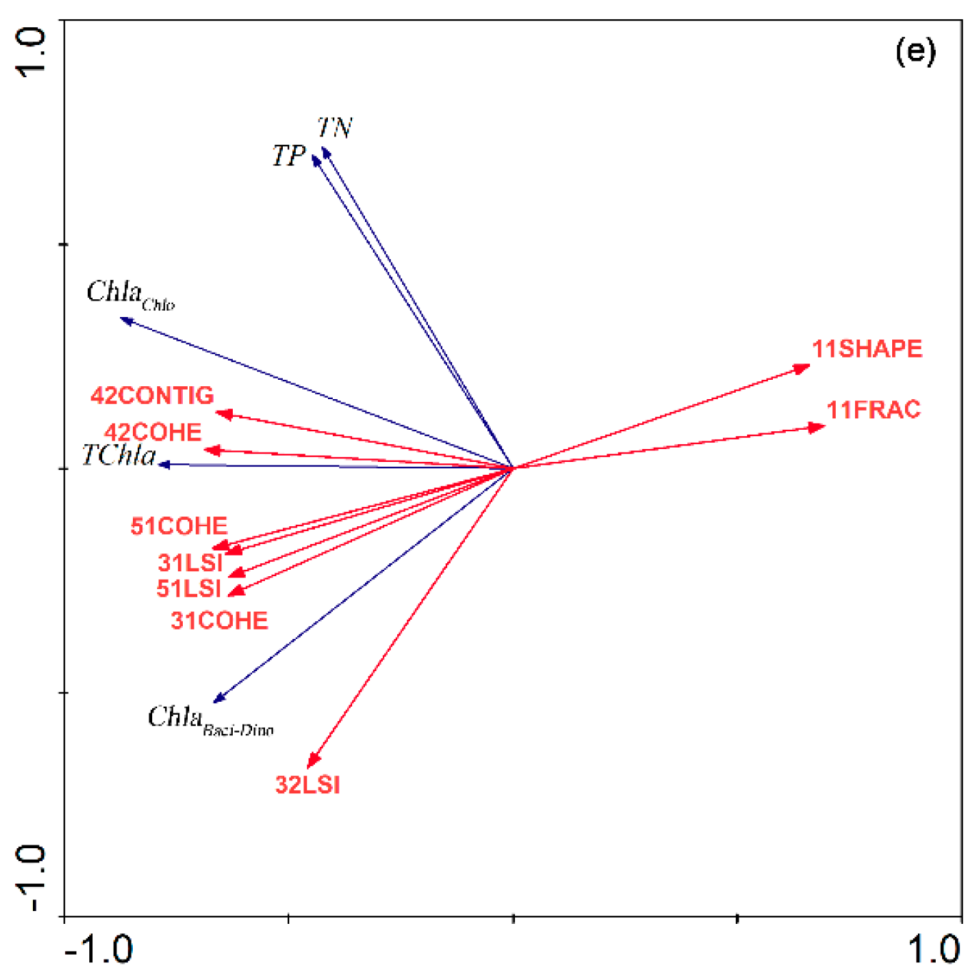
3.3.2. Land Use Pattern—Water Quality Relationships at Class Level
4. Discussion
4.1. Water Pollution in Urbanized Watershed
4.2. Influence of Landscape Patterns on Water Quality
4.3. Limits and Future Work
5. Conclusions
Author Contributions
Funding
Conflicts of Interest
References
- Grimm, N.B.; Faeth, S.H.; Golubiewski, N.E.; Redman, C.L.; Wu, J.; Bai, X.; Briggs, J.M. Global change and the ecology of cities. Science 2008, 319, 756–760. [Google Scholar] [CrossRef] [PubMed] [Green Version]
- Pielke, R.A. Land use and climate change. Science 2005, 310, 1625–1626. [Google Scholar] [CrossRef] [PubMed] [Green Version]
- Song, W.; Deng, X. Land-use/land-cover change and ecosystem service provision in China. Sci. Total Environ. 2017, 576, 705–719. [Google Scholar] [CrossRef]
- Guzha, A.; Rufino, M.C.; Okoth, S.; Jacobs, S.; Nóbrega, R. Impacts of land use and land cover change on surface runoff, discharge and low flows: Evidence from East Africa. J. Hydrol. Reg. Stud. 2018, 15, 49–67. [Google Scholar] [CrossRef]
- Borrelli, P.; Robinson, D.A.; Fleischer, L.R.; Lugato, E.; Ballabio, C.; Alewell, C.; Meusburger, K.; Modugno, S.; Schütt, B.; Ferro, V. An assessment of the global impact of 21st century land use change on soil erosion. Nat. Commun. 2017, 8, 1–13. [Google Scholar] [CrossRef] [Green Version]
- Charbonneau, R.; Kondolf, G. Land use change in California, USA: Nonpoint source water quality impacts. Environ. Manag. 1993, 17, 453–460. [Google Scholar] [CrossRef]
- Brett, M.T.; Arhonditsis, G.B.; Mueller, S.E.; Hartley, D.M.; Frodge, J.D.; Funke, D.E. Non-point-source impacts on stream nutrient concentrations along a forest to urban gradient. Environ. Manag. 2005, 35, 330–342. [Google Scholar] [CrossRef] [PubMed]
- Abdulkareem, J.H.; Sulaiman, W.N.A.; Pradhan, B.; Jamil, N.R. Long-term hydrologic impact assessment of non-point source pollution measured through Land Use/Land Cover (LULC) changes in a tropical complex catchment. Earth Syst. Environ. 2018, 2, 67–84. [Google Scholar] [CrossRef]
- Basnyat, P.; Teeter, L.D.; Lockaby, B.G.; Flynn, K.M. The use of remote sensing and GIS in watershed level analyses of non-point source pollution problems. For. Ecol. Manag. 2000, 128, 65–73. [Google Scholar] [CrossRef]
- Tong, S.T.; Chen, W. Modeling the relationship between land use and surface water quality. J. Environ. Manag. 2002, 66, 377–393. [Google Scholar] [CrossRef]
- White, M.J.; Storm, D.E.; Busteed, P.R.; Stoodley, S.H.; Phillips, S.J. Evaluating nonpoint source critical source area contributions at the watershed scale. J. Environ. Qual. 2009, 38, 1654–1663. [Google Scholar] [CrossRef] [PubMed]
- Tu, M.-C.; Smith, P. Modeling pollutant buildup and washoff parameters for SWMM based on land use in a semiarid urban watershed. Water Air Soil Pollut. 2018, 229, 121. [Google Scholar] [CrossRef]
- Welde, K.; Gebremariam, B. Effect of land use land cover dynamics on hydrological response of watershed: Case study of Tekeze Dam watershed, northern Ethiopia. Int. Soil Water Conserv. Res. 2017, 5, 1–16. [Google Scholar] [CrossRef]
- Turner, R.E.; Rabalais, N.N. Linking landscape and water quality in the Mississippi River Basin for 200 years. BioScience 2003, 53, 563–572. [Google Scholar] [CrossRef]
- McGrane, S.J. Impacts of urbanisation on hydrological and water quality dynamics, and urban water management: A review. Hydrol. Sci. J. 2016, 61, 2295–2311. [Google Scholar] [CrossRef]
- Schröder, B. Pattern, Process, and Function in Landscape Ecology and Catchment Hydrology? How Can Quantitative Landscape Ecology Support Predictions in Ungauged Basins? Hydrol. Earth Syst. Sci. 2006, 10, 967–979. [Google Scholar] [CrossRef] [Green Version]
- Turner, M.G. Landscape ecology: The effect of pattern on process. Annu. Rev. Ecol. Syst. 1989, 20, 171–197. [Google Scholar] [CrossRef]
- Ward, J.; Malard, F.; Tockner, K. Landscape ecology: A framework for integrating pattern and process in river corridors. Landsc. Ecol. 2002, 17, 35–45. [Google Scholar] [CrossRef]
- Arroyo-Rodríguez, V.; Melo, F.P.; Martínez-Ramos, M.; Bongers, F.; Chazdon, R.L.; Meave, J.A.; Norden, N.; Santos, B.A.; Leal, I.R.; Tabarelli, M. Multiple successional pathways in human-modified tropical landscapes: New insights from forest succession, forest fragmentation and landscape ecology research. Biol. Rev. 2017, 92, 326–340. [Google Scholar] [CrossRef]
- Alberti, M.; Booth, D.; Hill, K.; Coburn, B.; Avolio, C.; Coe, S.; Spirandelli, D. The impact of urban patterns on aquatic ecosystems: An empirical analysis in Puget lowland sub-basins. Landsc. Urban Plan. 2007, 80, 345–361. [Google Scholar] [CrossRef]
- Johnson, L.; Richards, C.; Host, G.; Arthur, J. Landscape influences on water chemistry in Midwestern stream ecosystems. Freshw. Biol. 1997, 37, 193–208. [Google Scholar] [CrossRef]
- Lee, S.-W.; Hwang, S.-J.; Lee, S.-B.; Hwang, H.-S.; Sung, H.-C. Landscape ecological approach to the relationships of land use patterns in watersheds to water quality characteristics. Landsc. Urban Plan. 2009, 92, 80–89. [Google Scholar] [CrossRef]
- Uuemaa, E.; Roosaare, J.; Mander, Ü. Landscape metrics as indicators of river water quality at catchment scale. Hydrol. Res. 2007, 38, 125–138. [Google Scholar] [CrossRef]
- Ding, J.; Jiang, Y.; Liu, Q.; Hou, Z.; Liao, J.; Fu, L.; Peng, Q. Influences of the land use pattern on water quality in low-order streams of the Dongjiang River basin, China: A multi-scale analysis. Sci. Total Environ. 2016, 551, 205–216. [Google Scholar] [CrossRef] [PubMed]
- Shi, P.; Zhang, Y.; Li, Z.; Li, P.; Xu, G. Influence of land use and land cover patterns on seasonal water quality at multi-spatial scales. Catena 2017, 151, 182–190. [Google Scholar] [CrossRef]
- Borah, D.; Bera, M. Watershed-scale hydrologic and nonpoint-source pollution models: Review of mathematical bases. Trans. ASAE 2003, 46, 1553. [Google Scholar] [CrossRef] [Green Version]
- Xiang, C.; Wang, Y.; Liu, H. A scientometrics review on nonpoint source pollution research. Ecol. Eng. 2017, 99, 400–408. [Google Scholar] [CrossRef]
- Fraga, I.; Charters, F.; O’Sullivan, A.; Cochrane, T. A novel modelling framework to prioritize estimation of non-point source pollution parameters for quantifying pollutant origin and discharge in urban catchments. J. Environ. Manag. 2016, 167, 75–84. [Google Scholar] [CrossRef]
- Arnold, C.L., Jr.; Gibbons, C.J. Impervious surface coverage: The emergence of a key environmental indicator. J. Am. Plan. Assoc. 1996, 62, 243–258. [Google Scholar] [CrossRef]
- Giri, S.; Qiu, Z. Understanding the relationship of land uses and water quality in Twenty First Century: A review. J. Environ. Manag. 2016, 173, 41–48. [Google Scholar] [CrossRef] [Green Version]
- Berka, C.; Schreier, H.; Hall, K. Linking water quality with agricultural intensification in a rural watershed. Water Air Soil Pollut. 2001, 127, 389–401. [Google Scholar] [CrossRef]
- Clément, F.; Ruiz, J.; Rodríguez, M.A.; Blais, D.; Campeau, S. Landscape diversity and forest edge density regulate stream water quality in agricultural catchments. Ecol. Indic. 2017, 72, 627–639. [Google Scholar] [CrossRef]
- Prepas, E.; Burke, J.; Whitson, I.; Putz, G.; Smith, D. Associations between watershed characteristics, runoff, and stream water quality: Hypothesis development for watershed disturbance experiments and modelling in the Forest Watershed and Riparian Disturbance (FORWARD) project. J. Environ. Eng. Sci. 2006, 5, S27–S37. [Google Scholar] [CrossRef]
- Shen, Z.; Hou, X.; Li, W.; Aini, G. Relating landscape characteristics to non-point source pollution in a typical urbanized watershed in the municipality of Beijing. Landsc. Urban Plan. 2014, 123, 96–107. [Google Scholar] [CrossRef]
- Ouyang, W.; Song, K.; Wang, X.; Hao, F. Non-point source pollution dynamics under long-term agricultural development and relationship with landscape dynamics. Ecol. Indic. 2014, 45, 579–589. [Google Scholar] [CrossRef]
- Liu, J.; Shen, Z.; Yan, T.; Yang, Y. Source identification and impact of landscape pattern on riverine nitrogen pollution in a typical urbanized watershed, Beijing, China. Sci. Total Environ. 2018, 628, 1296–1307. [Google Scholar] [CrossRef]
- Weng, Y.-C. Spatiotemporal changes of landscape pattern in response to urbanization. Landsc. Urban Plan. 2007, 81, 341–353. [Google Scholar] [CrossRef]
- Irwin, E.G.; Bockstael, N.E. The evolution of urban sprawl: Evidence of spatial heterogeneity and increasing land fragmentation. Proc. Natl. Acad. Sci. USA 2007, 104, 20672–20677. [Google Scholar] [CrossRef] [Green Version]
- Carey, R.O.; Migliaccio, K.W.; Li, Y.; Schaffer, B.; Kiker, G.A.; Brown, M.T. Land use disturbance indicators and water quality variability in the Biscayne Bay Watershed, Florida. Ecol. Indic. 2011, 11, 1093–1104. [Google Scholar] [CrossRef]
- Su, S.; Xiao, R.; Zhang, Y. Multi-scale analysis of spatially varying relationships between agricultural landscape patterns and urbanization using geographically weighted regression. Appl. Geogr. 2012, 32, 360–375. [Google Scholar] [CrossRef]
- Mainali, J.; Chang, H. Landscape and anthropogenic factors affecting spatial patterns of water quality trends in a large river basin, South Korea. J. Hydrol. 2018, 564, 26–40. [Google Scholar] [CrossRef]
- National Standard. Current Land Use Classification; (GB/T 21010–2017); China Quality and Standards Publishing & Media Co., Ltd.: Beijing, China, 2017. (In Chinese) [Google Scholar]
- Klonus, S.; Ehlers, M. Image fusion using the Ehlers spectral characteristics preservation algorithm. Gisci. Remote Sens. 2007, 44, 93–116. [Google Scholar] [CrossRef]
- Song, Y.; Shao, G.; Song, X.; Liu, Y.; Pan, L.; Ye, H. The relationships between urban form and urban commuting: An empirical study in China. Sustainability 2017, 9, 1150. [Google Scholar] [CrossRef] [Green Version]
- O’Callaghan, J.F.; Mark, D.M. The Extraction of Drainage Networks From Digital Elevation Data. Comput. Vis. Graph. Image Process. 1984, 27, 323–344. [Google Scholar] [CrossRef]
- Saunders, W.K.; Maidment, D.R. A GIS Assessment of Nonpoint Source Pollution in the San Antonio-Nueces Coastal Basin; Center for Research in Water Resources, University of Texas at Austin: Austin, TX, USA, 1996. [Google Scholar]
- Costa-Cabral, M.C.; Burges, S.J. Digital elevation model networks (DEMON): A model of flow over hillslopes for computation of contributing and dispersal areas. Water Resour. Res. 1994, 30, 1681–1692. [Google Scholar] [CrossRef]
- Tarboton, D.G. A new method for the determination of flow directions and upslope areas in grid digital elevation models. Water Resour. Res. 1997, 33, 309–319. [Google Scholar] [CrossRef] [Green Version]
- Turcotte, R.; Fortin, J.-P.; Rousseau, A.; Massicotte, S.; Villeneuve, J.-P. Determination of the drainage structure of a watershed using a digital elevation model and a digital river and lake network. J. Hydrol. 2001, 240, 225–242. [Google Scholar] [CrossRef]
- Duke, G.D.; Kienzle, S.W.; Johnson, D.L.; Byrne, J.M. Improving overland flow routing by incorporating ancillary road data into digital elevation models. J. Spat. Hydrol. 2003, 3, 1–27. [Google Scholar]
- Callow, J.N.; Van Niel, K.P.; Boggs, G.S. How does modifying a DEM to reflect known hydrology affect subsequent terrain analysis? J. Hydrol. 2007, 332, 30–39. [Google Scholar] [CrossRef]
- Dongquan, Z.; Jining, C.; Haozheng, W.; Qingyuan, T.; Shangbing, C.; Zheng, S. GIS-based urban rainfall-runoff modeling using an automatic catchment-discretization approach: A case study in Macau. Environ. Earth Sci. 2009, 59, 465. [Google Scholar] [CrossRef]
- Lai, Z.; Li, S.; Lv, G.; Pan, Z.; Fei, G. Watershed delineation using hydrographic features and a DEM in plain river network region. Hydrol. Process. 2016, 30, 276–288. [Google Scholar] [CrossRef]
- Zhang, G.; Guhathakurta, S.; Dai, G.; Wu, L.; Yan, L. The control of land-use patterns for stormwater management at multiple spatial scales. Environ. Manag. 2013, 51, 555–570. [Google Scholar] [CrossRef] [PubMed]
- Zhang, X.; Liu, Y.; Zhou, L. Correlation analysis between landscape metrics and water quality under multiple scales. Int. J. Environ. Res. Public Health 2018, 15, 1606. [Google Scholar] [CrossRef] [Green Version]
- Wang, X.; Zhang, F. Multi-scale analysis of the relationship between landscape patterns and a water quality index (WQI) based on a stepwise linear regression (SLR) and geographically weighted regression (GWR) in the Ebinur Lake oasis. Environ. Sci. Pollut. Res. 2018, 25, 7033–7048. [Google Scholar] [CrossRef] [PubMed]
- Haidary, A.; Amiri, B.J.; Adamowski, J.; Fohrer, N.; Nakane, K. Assessing the impacts of four land use types on the water quality of wetlands in Japan. Water Resour. Manag. 2013, 27, 2217–2229. [Google Scholar] [CrossRef]
- Basnyat, P.; Teeter, L.D.; Flynn, K.M.; Lockaby, B.G. Relationships between landscape characteristics and nonpoint source pollution inputs to coastal estuaries. Environ. Manag. 1999, 23, 539–549. [Google Scholar] [CrossRef]
- Kändler, M.; Blechinger, K.; Seidler, C.; Pavlů, V.; Šanda, M.; Dostál, T.; Krása, J.; Vitvar, T.; Štich, M. Impact of land use on water quality in the upper Nisa catchment in the Czech Republic and in Germany. Sci. Total Environ. 2017, 586, 1316–1325. [Google Scholar] [CrossRef]
- Shen, Z.; Hou, X.; Li, W.; Aini, G.; Chen, L.; Gong, Y. Impact of landscape pattern at multiple spatial scales on water quality: A case study in a typical urbanised watershed in China. Ecol. Indic. 2015, 48, 417–427. [Google Scholar] [CrossRef]
- Zhao, J.; Lin, L.; Yang, K.; Liu, Q.; Qian, G. Influences of land use on water quality in a reticular river network area: A case study in Shanghai, China. Landsc. Urban Plan. 2015, 137, 20–29. [Google Scholar] [CrossRef]
- Pan, Y.; Herlihy, A.; Kaufmann, P.; Wigington, J.; Van Sickle, J.; Moser, T. Linkages among land-use, water quality, physical habitat conditions and lotic diatom assemblages: A multi-spatial scale assessment. Hydrobiologia 2004, 515, 59–73. [Google Scholar] [CrossRef]
- Ter Braak, C.J.; Smilauer, P. Canoco Reference Manual and User’s Guide: Software for Ordination; Version 5.0; Microcomputer Power: Ithaca, NY, USA, 2012. [Google Scholar]
- Vollenweider, R.A.; Kerekes, J.J. Eutrophication of Waters: Monitoring, Assessment and Control; OECD: Paris, France, 1982. [Google Scholar]
- Brabec, E.; Schulte, S.; Richards, P.L. Impervious surfaces and water quality: A review of current literature and its implications for watershed planning. J. Plan. Lit. 2002, 16, 499–514. [Google Scholar] [CrossRef]
- Schiff, R.; Benoit, G. Effects of Impervious Cover at Multiple Spatial Scales on Coastal Watershed Streams 1. Jawra J. Am. Water Resour. Assoc. 2007, 43, 712–730. [Google Scholar] [CrossRef]
- Zampella, R.A.; Procopio, N.A.; Lathrop, R.G.; Dow, C.L. Relationship of Land-Use/Land-Cover Patterns and Surface-Water Quality in The Mullica River Basin. Jawra J. Am. Water Resour. Assoc. 2007, 43, 594–604. [Google Scholar] [CrossRef]
- Klein, R.D. Urbanization and stream quality impairment. Jawra J. Am. Water Resour. Assoc. 1979, 15, 948–963. [Google Scholar] [CrossRef]
- Sliva, L.; Williams, D.D. Buffer zone versus whole catchment approaches to studying land use impact on river water quality. Water Res. 2001, 35, 3462–3472. [Google Scholar] [CrossRef]
- Ren, W.; Zhong, Y.; Meligrana, J.; Anderson, B.; Watt, W.E.; Chen, J.; Leung, H.-L. Urbanization, land use, and water quality in Shanghai: 1947–1996. Environ. Int. 2003, 29, 649–659. [Google Scholar]
- Rodríguez-Romero, A.J.; Rico-Sánchez, A.E.; Mendoza-Martínez, E.; Gómez-Ruiz, A.; Sedeño-Díaz, J.E.; López-López, E. Impact of changes of land use on water quality, from tropical forest to anthropogenic occupation: A multivariate approach. Water 2018, 10, 1518. [Google Scholar] [CrossRef] [Green Version]
- Elliott, J.; Jones, I.; Thackeray, S. Testing the sensitivity of phytoplankton communities to changes in water temperature and nutrient load, in a temperate lake. Hydrobiologia 2006, 559, 401–411. [Google Scholar] [CrossRef]
- Rimet, F. Recent views on river pollution and diatoms. Hydrobiologia 2012, 683, 1–24. [Google Scholar] [CrossRef]
- Moreno-Mateos, D.; Mander, Ü.; Comín, F.A.; Pedrocchi, C.; Uuemaa, E. Relationships between landscape pattern, wetland characteristics, and water quality in agricultural catchments. J. Environ. Qual. 2008, 37, 2170–2180. [Google Scholar] [CrossRef]
- Deng, J.S.; Wang, K.; Hong, Y.; Qi, J.G. Spatio-temporal dynamics and evolution of land use change and landscape pattern in response to rapid urbanization. Landsc. Urban Plan. 2009, 92, 187–198. [Google Scholar] [CrossRef]
- Dewan, A.M.; Yamaguchi, Y. Land use and land cover change in Greater Dhaka, Bangladesh: Using remote sensing to promote sustainable urbanization. Appl. Geogr. 2009, 29, 390–401. [Google Scholar] [CrossRef]
- Bu, H.; Wei, M.; Yuan, Z.; Wan, J. Relationships between land use patterns and water quality in the Taizi River basin, China. Ecol. Indic. 2014, 41, 187–197. [Google Scholar] [CrossRef]
- Ai, L.; Shi, Z.H.; Yin, W.; Huang, X. Spatial and seasonal patterns in stream water contamination acrossmountainous watersheds: Linkage with landscape characteristics. J. Hydrol. 2015, 523, 398–408. [Google Scholar] [CrossRef]
- Zhao, K.; Wu, H.; Chen, W.; Sun, W.; Zhang, H.; Duan, W.; Chen, W.; He, B. Impacts of landscapes on water quality in a typical headwater catchment, southeastern China. Sustainability 2020, 12, 721. [Google Scholar] [CrossRef] [Green Version]
- Wang, Y.; Shen, J.; Yan, W.; Chen, C. Effects of landscape development intensity on river water quality in urbanized areas. Sustainability 2019, 11, 7120. [Google Scholar] [CrossRef] [Green Version]
- Huang, Z.; Han, L.; Zeng, L.; Xiao, W.; Tian, Y. Effects of land use patterns on stream water quality: A case study of a small-scale watershed in the Three Gorges Reservoir Area, China. Environ. Sci. Pollut. Res. 2016, 23, 3943–3955. [Google Scholar] [CrossRef]
- De Mello, K.; Valente, R.A.; Randhir, T.O.; dos Santos, A.C.A.; Vettorazzi, C.A. Effects of land use and land cover on water quality of low-order streams in Southeastern Brazil: Watershed versus riparian zone. Catena 2018, 167, 130–138. [Google Scholar] [CrossRef]
- Uttara, S.; Bhuvandas, N.; Aggarwal, V. Impacts of urbanization on environment. Int. J. Res. Eng. Appl. Sci. 2012, 2, 1637–1645. [Google Scholar]
- Uuemaa, E.; Roosaare, J.; Mander, Ü. Scale dependence of landscape metrics and their indicatory value for nutrient and organic matter losses from catchments. Ecol. Indic. 2005, 5, 350–369. [Google Scholar] [CrossRef]
- McGarigal, FRAGSTATS v4.2: Spatial Pattern Analysis Program for Categorical and Continuous Maps. Computer Produced by the Authors. 2015, pp. 1–182. Available online: https://www.umass.edu/landeco/research/fragstats/downloads/fragstats_downloads.html/ (accessed on 23 January 2019).
- Uuemaa, E.; Antrop, M.; Roosaare, J.; Marja, R.; Mander, Ü. Landscape metrics and indices: An overview of their use in landscape research. Living Rev. Landsc. Res. 2009, 3, 1–28. [Google Scholar] [CrossRef]


| Category | Name (Abbreviation) | Unit | Description | Level |
|---|---|---|---|---|
| Dominance | Percentage of Landscape (PLAND) | % | Percentage of landscape comprised of corresponding patch type. | Class |
| Largest Patch Index (LPI) | % | The proportion of total area occupied by the largest patch of a patch type. | Class, Landscape | |
| Shape complexity | Mean Shape Index (SHAPE) | unitless | Mean patch perimeter divided by the minimum perimeter of the corresponding land use area. | Class, Landscape |
| Mean Fractal Dimension Index (FRAC) | unitless | The sum of 2 times the logarithm of patch perimeter divided by the logarithm of the total area for the corresponding patch type divided by the number of patches. | Class, Landscape | |
| Mean Perimeter-Area Ratio (PARA) | unitless | Equals 2 divided by the slope of the regression line obtained by regressing the logarithm of patch area against the logarithm of patch perimeter. | Class, Landscape | |
| Landscape Shape Index (LSI) | unitless | The perimeter-to-area ratio for the corresponding class. LSI increases with irregular shapes. | Class, Landscape | |
| Fragmentation | Total Edge (TE) | m | Equals the sum of the lengths of all edge segments involving the corresponding patch type. | Class, Landscape |
| Edge Density (ED) | m/ha | Total length of all edge segments divided by total area for the corresponding patch type. | Class, Landscape | |
| Number of Patches (NP) | unitless | Equals the number of patches in the landscape. | Class, Landscape | |
| Patch Density (PD) | n/km2 | Expresses the number of patches of the corresponding patch type per unit area. | Class, Landscape | |
| Landscape Division Index (DIVISION) | % | Equals to 1 minus the area of the plaque divided by the sum of squares of the landscape comprised of the corresponding patch type. | Class, Landscape | |
| Aggregation and Connectedness | Contagion (CONTAG) | % | Extent to which patch types are aggregated or clumped as a percentage of the maximum possible. | Landscape |
| Interspersion and Juxtaposition Index (IJI) | % | Equals the observed interspersion over the maximum possible interspersion for the given number of patch types | Class, Landscape | |
| Aggregation Index (AI) | % | Number of like adjacencies involving the corresponding class, divided by the maximum possible number of like adjacencies involving the corresponding land use type. | Class, Landscape | |
| Cohesion Index (COHE) | unitless | Indicates the physical connectedness of the corresponding patch type. | Class, Landscape | |
| Mean Contiguity Index (CONTIG) | unitless | Assessing patch shape based on the spatial connectedness of cells within a patch. | Class | |
| Diversity | Patch Richness (PR) | unitless | Equals the number of different patch types present within the landscape boundary. | Landscape |
| Shannon’s Diversity Index (SHDI) | unitless | Equals minus the sum, across all patch types, of the proportional abundance of each patch type multiplied by that proportion. | Landscape |
| Indicator | Maximum | Minimum | Mean (std.) |
|---|---|---|---|
| TN (mg/L) | 31.69 | 1.88 | 6.54 (6.65) |
| TP (mg/L) | 2.80 | 0.09 | 0.62 (0.64) |
| TChla 1 (μg/L) | 328.84 | 2.08 | 102.49 (94.08) |
| ChlaCyan 2 (μg/L) | 130.43 | 0.00 | 9.9 (30.30) |
| ChlaChlo 3 (μg/L) | 233.29 | 0.00 | 68.44 (77.87) |
| ChlaBaci-Dino 4 (μg/L) | 138.74 | 0.00 | 24.15 (33.93) |
| TN | TP | TChla | ChlaCyan | ChlaChlo | ChlaBaci-Dino | |
|---|---|---|---|---|---|---|
| TN | 1 | |||||
| TP | 0.791 ** | 1 | ||||
| TChla | 0.269 | 0.677 ** | 1 | |||
| ChlaCyan | −0.429 | −0.327 | 0.067 | 1 | ||
| ChlaChlo | 0.541 * | 0.798 ** | 0.765 ** | −0.313 | 1 | |
| ChlaBaci-Dino | −0.167 | 0.097 | 0.35 | 0.121 | 0.318 | 1 |
| Response | Regression | Adjusted R2 | P |
|---|---|---|---|
| TP | TP = 0.215 + 0.127 × Industrial | 0.352 | 0.048 |
| TChla | TChla = 1.630 + 0.822 × Industrial + 0.656 × Bareland | 0.688 | 0.000 |
| ChlaChlo | ChlaChlo = 2.164 + 0.775 × Bareland | 0.437 | 0.035 |
| ChlaBaci-Dino | ChlaBaci-Dino = 1.025 + 0.761 × Bareland | 0.414 | 0.046 |
| Response | Regression | Adjusted R2 | P |
|---|---|---|---|
| TN | TN = 7.318 − 0.738 × PARA 1 | 0.463 | 0.025 |
| TP | TP = 3.108 − 0.359 × PARA | 0.396 | 0.033 |
| TChla | TChla = −2.342 + 6.297 × SHDI 2 | 0.722 | 0.000 |
| ChlaChlo | ChlaChlo = −2.766 + 6.080 × SHDI | 0.539 | 0.001 |
| ChlaBaci-Dino | ChlaBaci-Dino = 18.345 − 15.129 × SHAPE 3 | 0.455 | 0.004 |
| Land Use Class | Explained Variation (%) | Selected Explanatory Variables (p < 0.05) | ||
|---|---|---|---|---|
| Axis 1 | Axis 2 | All Axes | ||
| Cropland | 30.9 | 3.5 | 37.9 | 11SHAPE, 11FRAC |
| Forest and wetland | 40.8 | 10.9 | 54.6 | 21SHAPE, 31LSI, 32LSI, 31SHAPE, 31COHE |
| Built-up | 49.0 | 16.9 | 71.4 | 42CONTIG, 42COHE, 45PLAND, 45PD, 46PLAND, 46ED, 47PD |
| Bareland | 29.7 | 3.9 | 34.6 | 51PLAND, 51LSI, 51CONTIG, 51COHE |
| All types | 56.8 | 18.3 | 84.1 | 42COHE, 42CONTIG, 11FRAC, 11SHAPE, 51COHE, 31COHE, 31LSI, 51LSI, 32LSI |
© 2020 by the authors. Licensee MDPI, Basel, Switzerland. This article is an open access article distributed under the terms and conditions of the Creative Commons Attribution (CC BY) license (http://creativecommons.org/licenses/by/4.0/).
Share and Cite
Song, Y.; Song, X.; Shao, G. Response of Water Quality to Landscape Patterns in an Urbanized Watershed in Hangzhou, China. Sustainability 2020, 12, 5500. https://doi.org/10.3390/su12145500
Song Y, Song X, Shao G. Response of Water Quality to Landscape Patterns in an Urbanized Watershed in Hangzhou, China. Sustainability. 2020; 12(14):5500. https://doi.org/10.3390/su12145500
Chicago/Turabian StyleSong, Yu, Xiaodong Song, and Guofan Shao. 2020. "Response of Water Quality to Landscape Patterns in an Urbanized Watershed in Hangzhou, China" Sustainability 12, no. 14: 5500. https://doi.org/10.3390/su12145500
APA StyleSong, Y., Song, X., & Shao, G. (2020). Response of Water Quality to Landscape Patterns in an Urbanized Watershed in Hangzhou, China. Sustainability, 12(14), 5500. https://doi.org/10.3390/su12145500