Article

The Integrated Spatial Pattern of Child Mortality during the 2012–2016 Drought in La Guajira, Colombia

School of Engineering, Newcastle University, Newcastle upon Tyne NE1 7RU, UK
Sustainability 2019, 11(24), 7190; https://doi.org/10.3390/su11247190
Submission received: 25 November 2019 / Revised: 7 December 2019 / Accepted: 12 December 2019 / Published: 15 December 2019
(This article belongs to the Special Issue Climate Risk and Vulnerability Mapping)

Abstract

:
The El Niño phenomenon in 2012 triggered a drought in La Guajira, Colombia that extended until 2016. In this period, the average child mortality rate in the area reached 23.4 out of 1000. The aim of this paper is to identify the integrated spatial pattern (ISP) of a single indicator in this case; child mortality. At the same time, the ISP identifies causes and priority areas for action. The socio-economic vulnerability (SEV) variables and spatial indicators related to child mortality were selected from the literature review and through meetings, workshops, and interviews with the affected community during fieldwork. Using correlation analysis and stepwise regression, the SEV variables with more accountability in child mortality during the drought were identified: Households with a monthly income of less than 100 USD, the number of people older than 65, and the number of people younger than 5 years old. Allocating weights to the SEV variables according to their degree of accountability in child mortality, its ISP has been identified. The far north of La Guajira was detected as the area most affected by child mortality and was, therefore, the priority zone for implementing actions focused on generating new sources of income.

1. Introduction

According to the United Nations Children’s Fund (UNICEF), child mortality includes neonatal mortality, under-five mortality and the mortality of children between five and fourteen. The outstanding progress in reducing the amount of child mortality worldwide is reflected in a child mortality rate of one in twenty-six children who died before reaching age five by 2018, compared to the 1990s, when the same rate was one in eleven [1]. The estimated child mortality rate in Colombia was 16.8 deaths of children out of 1000 born alive in 2016, showing an annual downward variation of −1.76% with respect to 2015 [2]. Nevertheless, in contrast to the rest of the country, the child mortality rates in La Guajira (Colombia) reached an average of 23.4 out of 1000 born alive [3], above the national rate, by 2016. Between 2012 and 2016, a long drought took place in La Guajira due to the El Niño phenomenon. The monthly average precipitation in the high Guajira dropped from 30 mm in 2012 to as little as 5 mm in 2015 [4]. The water scarcity reduced crop production and led to food insecurity within the department. The motivation for this research is to call the attention of the academic community to the consequences of climate change in one region in Latin America, considering that currently most of the attention is focused on the affected areas in Africa and Asia.
The aim of this paper is to develop a methodology to create a spatial composite indicator, named an integrated spatial pattern (ISP), of a specific phenomenon at a local level, in this case, child mortality. I selected child mortality as the phenomenon to test this methodology because one of the indicators used to benchmark the severity of a crisis is the official number of child mortalities [5,6]. Moreover, I consider this phenomenon to be the most serious consequence of the drought in the selected case study area. This paper is divided into seven sections. This first section is the introduction, while the second section reviews the literature on the concept of drought and the socio-economic vulnerability (SEV) variables and spatial indicators associated with this phenomenon. The third section describes the methodology, including the case study area, the data collection, the statistical analysis, the weights allocation, and the identification of the ISP of child mortality in La Guajira, Colombia. The fourth and fifth sections describe and discuss the results, respectively. Finally, the sixth section presents the conclusions, and the seventh section proposes a set of recommendations for the priority areas identified by the ISP.

2. Literature Review

Drought is a natural phenomenon that stresses the agriculture sector and, after floods, is the second-most geographically extensive hazard faced by the population [7]. It is responsible for impacting human life and activities, as well as for generating financial losses [7,8,9,10]. A complex network of interacting physical and anthropogenic factors are linked to the occurrence of a drought [11,12,13]. There are several definitions of a drought, but the most common and pragmatic is the reduction in water availability due to below-average precipitation [14]. In particular, on non-irrigated land, this leads to a reduction or loss of harvest [13]. The high intensity and duration in the shortage of subsurface and surface water affects the functioning of a natural eco-system, leading to drought [15]. The main factor responsible for drought is the deficiency in rainfall, while the severity is determined by factors such as the distribution, timing, and intensity of the rainfall [10]. However, drought goes beyond a natural phenomenon consisting of a lack of rainfall and decline in animal production and agricultural plants; it also includes the disruptions of relations within and between the social and economic spheres and the physical environment. Until the late 1980s, drought was understood as a critical disturbance of the economic system of food supply and demand [16]. Drought has a broad range of meanings for the affected population, such as hunger, wants, lack, needs, marginal or unsustainable situations, and insecure livelihoods [16].
There are two common definitions of drought within the literature; a conceptual definition and an operational one [17]. The former describes drought as a natural hazard that is caused by a reduction in precipitation, which results in insufficient water being available to meet the needs of human activities or ecosystems [18]. The operational definition focuses upon identifying the beginning, end, and severity of droughts. According to the conceptual definition, there are four kinds of droughts: Meteorological or climatological, hydrological, agricultural, and socio-economic [7,19,20,21]. The continued shortage of precipitation is defined as a meteorological drought, and it usually triggers other kinds of droughts and affects large areas. Hydrological drought is considered to be a period of low flows and below-normal flows in watercourses, lakes, and groundwater levels. Agricultural drought occurs when there is insufficient moisture in the root area of plants to meet the needs of crops due to extensive water losses because of evapotranspiration [22,23]. Finally, socio-economic drought is linked to the effect of water scarcity on people and economic activity, which causes social and environmental impacts [19,24,25].
Socio-economic indicators are associated with sensitivity and resilience to drought; nevertheless, there is no robust literature on how the socio-economic factors exacerbate the effect of climate change on crop productivity [26]. Climate influences the relation of components such as water and food and plays a role in estimating the SEV [27]. In recent years, there has been a high fluctuation in rainfall that is insufficient to cover human and environmental needs [28,29], thus increasing SEV [26]. The level of vulnerability is augmented by the literacy rate and the careless use of natural resources [30]. According to Yaduvanshi et al. [7], the datasets required to estimate SEV are demography, livestock population, growth rate, water and fodder requirements, the severity of crop failure, and industrial development. These authors have defined the social vulnerability of their case study area by integrating all the socio-economic indicators. The qualitative-quantitative spectrum of research in the literature links socio-economic factors with climate change impacts and agriculture. On the qualitative spectrum, researchers use a ‘livelihoods approach’ to understand a local adaptation to environmental shocks in the past. These studies aim to understand how communities or households use different types of assets or human, social, environmental, political, and/or financial capital to overcome problems [26]. Brooks et al. [31] have made an initial attempt to define factors and use statistical methods to link national-level socio-economic data with data about mortality due to natural phenomena and identify key factors that correlate with the impacts of extreme weather events in the past. The socio-economic indicators considered by Simelton et al. [26] were available land (m2), agricultural land (m2), total population (number), rural population (number), urbanisation rate (%), machinery power (kW), irrigated area (ha), fertiliser (ton), agricultural electricity supply (kWh), agricultural production capital (yuan/capita), fixed capital (yuan/farmer), investment in agriculture (yuan/capita), GDP in agriculture (yuan/capita, %), GDP in other agricultural activities (%), expenditure (yuan/capita), and rail density (Km/Km2). The authors found that the land used pattern (double-cropping or the amount of agricultural land) and economic factors (GDP) are associated with crop-drought vulnerability across China. Socio-economic indicators related to land, labour, and economic inputs are associated with reduced vulnerability in sensitive farming systems.
Drought is a creeping phenomenon that requires the constant variation and adaptation of household strategies. Usually, temporary and spatial patterns have been adapted to mitigate the negative effects of drought [16]. In the early stages, households start eating less than normal. The next step is usually to take a loan out on equipment and animals. In case the drought becomes more severe, the households sell assets such as working animals, equipment, and seeds. Migration is the last option [32]; temporary migration can be noted even in non-drought years. Nevertheless, during a drought, it increases significantly as the most effective coping strategy [13].

3. Methods

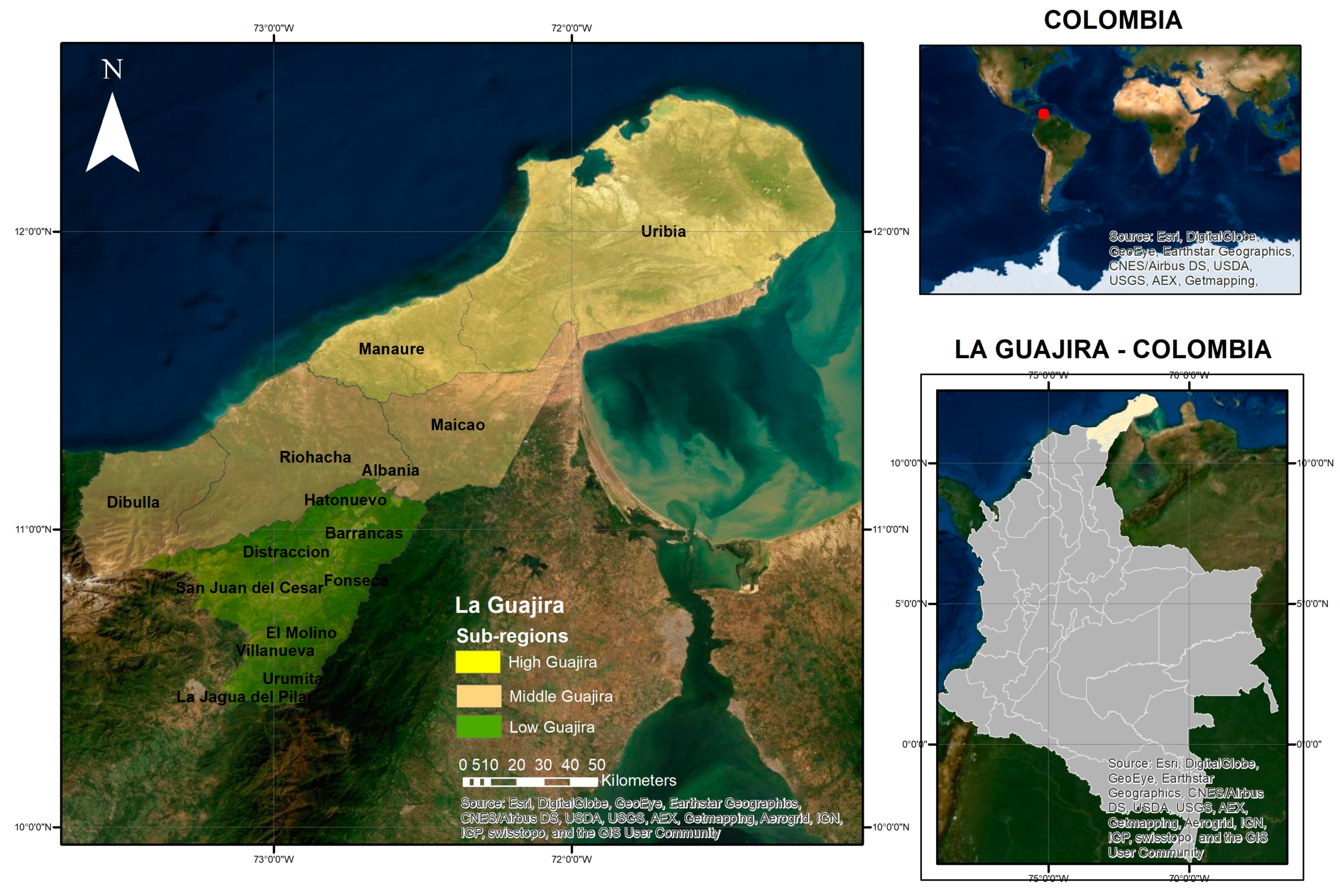
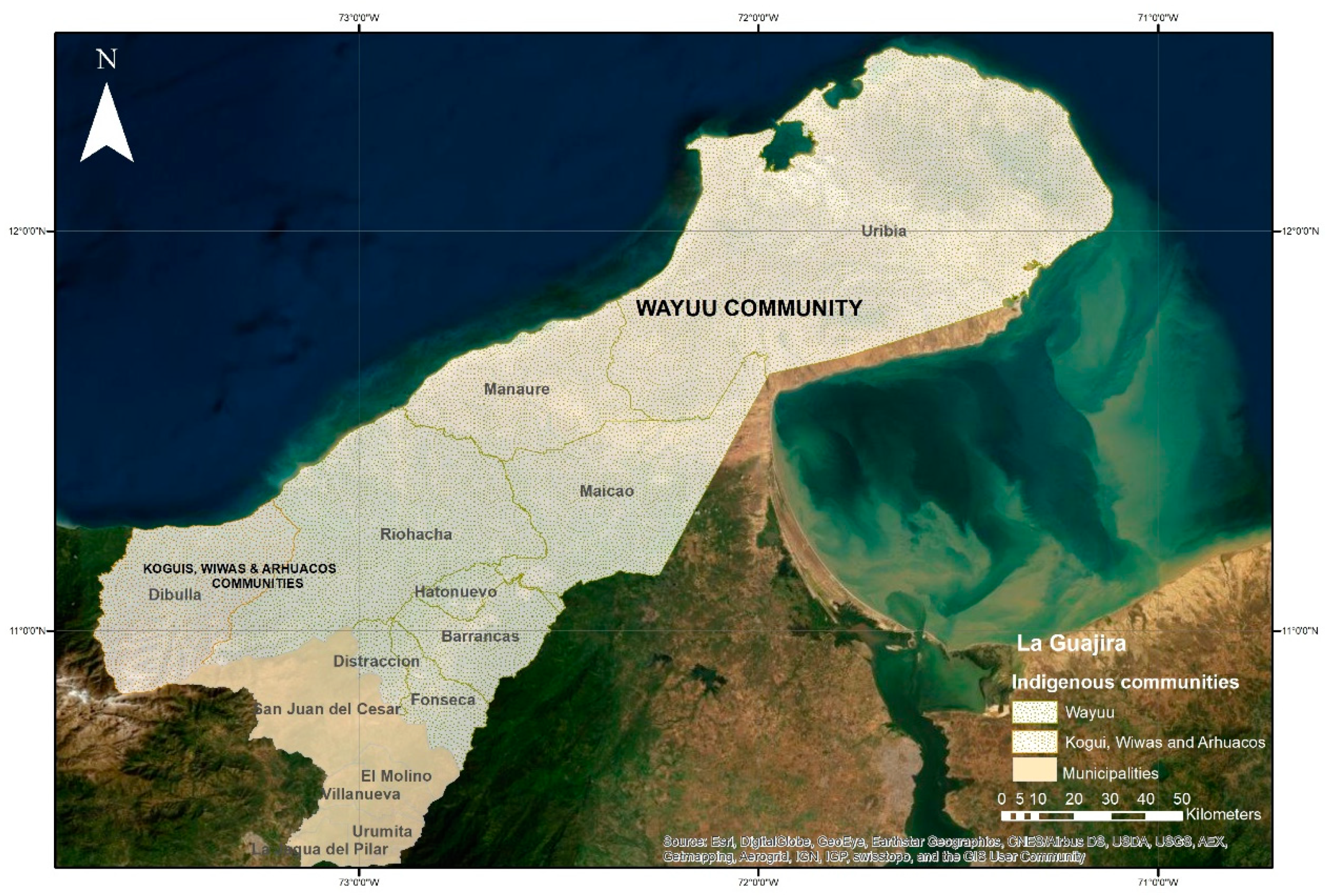
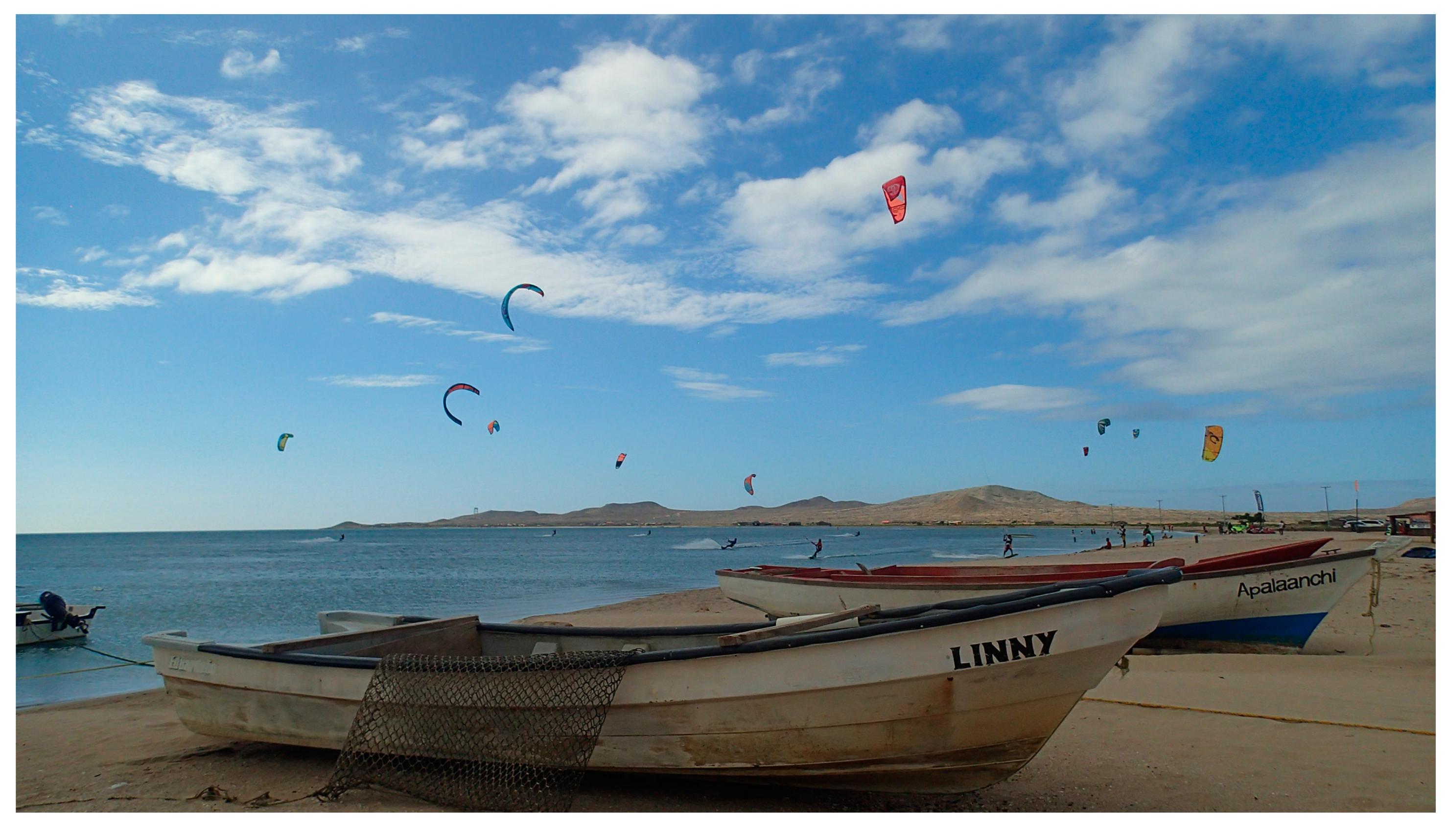
3.1. Case Study Area

Colombia is divided into 32 departments, one of which is La Guajira. In turn, this department is divided into 15 municipalities, as depicted in Figure 1. The department is distributed between three natural sub-regions; high, medium, and low Guajira, as presented in Figure 1. In the high Guajira, a semi-desert area, the vegetation is scarce. Settlements in this zone are spread out with no urban centres, and they are based on parcels that belong to specific clans. [3]. The mid Guajira has high agricultural potential, but most of the area consists of semi-desert zones with some forest. The best conditions for agriculture are in the low Guajira due to its proximity to the Santa Marta and the Perijá mountain ranges (DANE, 2015), which also denote closeness to water sources. Within this region, small cities are located along the valleys of the Rancheria and El Cesar rivers [3].
The precipitation in La Guajira is less than 500 mm per year, and temperatures vary between 35 °C and 42 °C [33]. Within La Guajira, 44.9% of the population is composed of indigenous peoples [3]. The Wayuu is the largest ethnic community in La Guajira and in Colombia, and it is also one of the most vulnerable. This community constitutes 20% of the indigenous population in Colombia, and its territory covers the high Guajira and part of the medium and low Guajira, as shown in Figure 2.
The Wayuu community lives in the rural areas of the department in small settlements called rancherías. Each settlement consists of five or six houses built with mud and wood. Each rancheria is a few minutes from the next. The Wayuu women sell handicrafts that they make, as shown in Figure 3, while the men stay at home and take care of the cattle, the crops, and the children.
The men of the Wayuu community, during the dry season, migrate to other regions to seek grass for their cattle or to secure jobs in salt extraction [34]. During the 18th and 19th centuries, members of the Wayuu community migrated to Venezuela to work on the cocoa, coffee, and indigo plantations. This migration further intensified in the 20th century with the demand for labour forces in various oil facilities in Venezuela [35]. In addition, smuggling has been one of the most representative economic activities since the Spanish conquerors’ arrival in this region, and it remained prevalent until the 1970s, when the trafficing of marijuana became an alternative source of income for the region. Accordingly, the members of the Wayuu community have long been known for their coping capacity and adaptation strategies for surviving in the desert [35]. Nevertheless, famine among the Wayuu children was recorded in 1776 by members of the Spanish army and in 1920 and 1973 by other researchers [36].
In addition to the drought, this time, the water scarcity in La Guajira was caused by a lack of infrastructure. The water supply system covers 87% of the urban zone and only 22% of the rural areas of the department, while in the rest of the country the supply reaches 97% and 73%, respectively [3]. The SEV variables and spatial indicators related to child mortality were selected from the literature review and through meetings with NGOs, workshops with community and governmental representatives, and interviews with members of the community in the case study area during fieldwork. The spatial pattern and the root causes of the indicator under study, child mortality, were identified using correlation and stepwise regression analysis and indicator weights, which were allocated according to the level of their accountability in the average rate of child mortality according to the regression analysis. A summary of the methodology is presented in Figure 4.

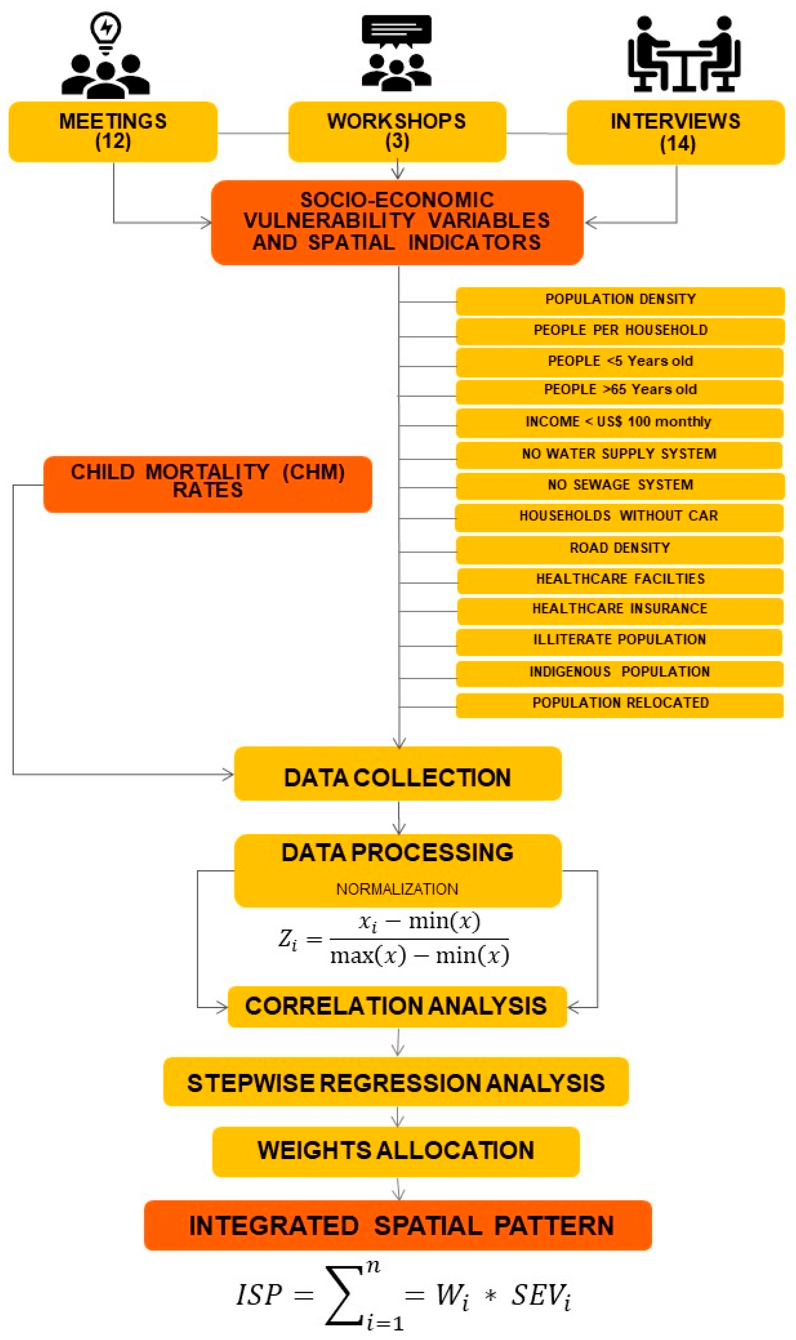
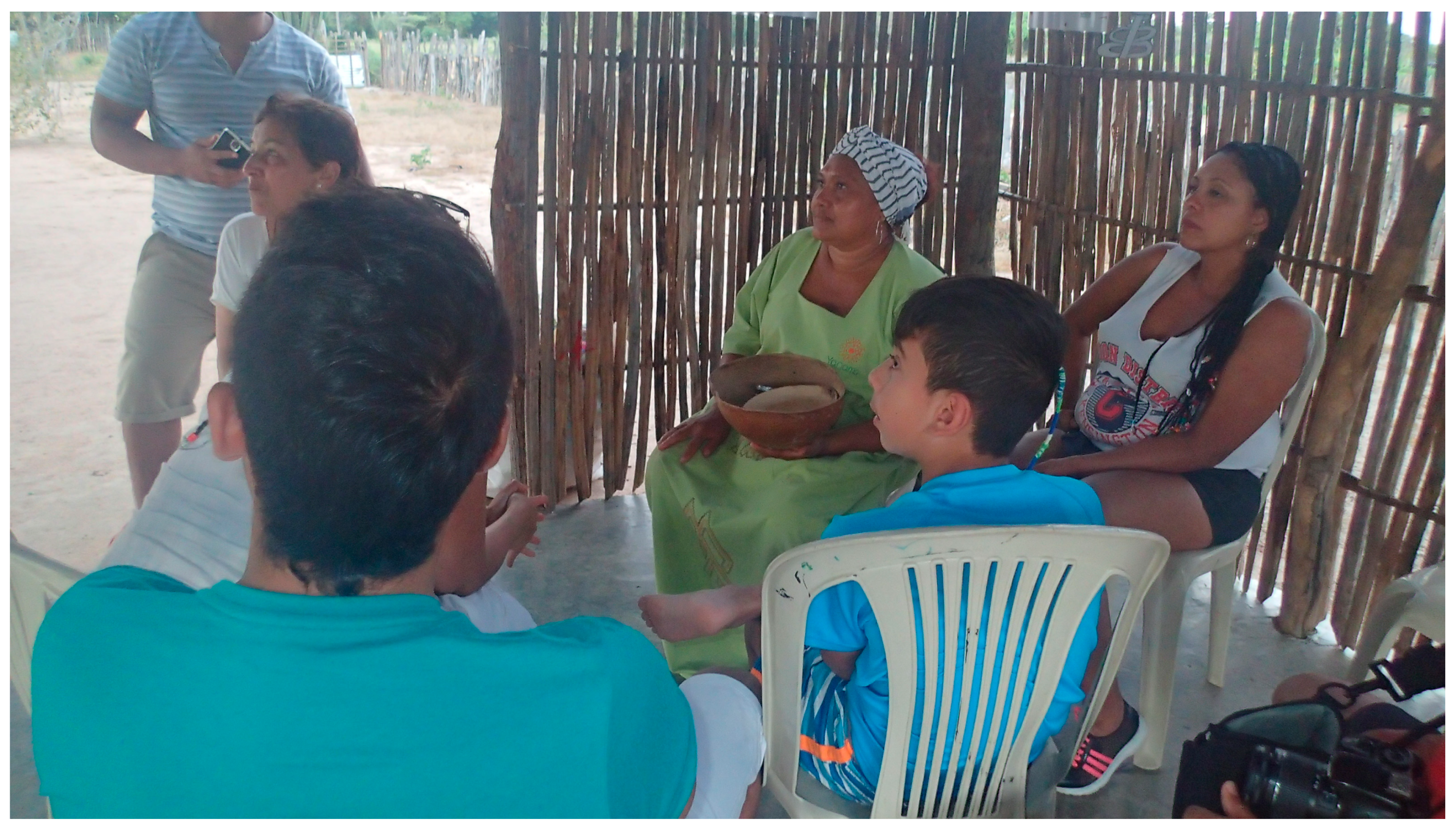
3.2. Data Collection

I collected primary and secondary data for the region of La Guajira. The primary data consisted of mainly qualitative data that I collected in fieldwork through interviews (14), meetings (12), and workshops (3). Between January 2017 and September 2018, 14 interviews with community members took place in the city of Riohacha and the townships of Atnamana-I, Chancleta, and Camarones. In addition, 12 meetings [37] were held with representatives of government institutions and NGOs. Three workshops also took place; two with community [38] groups from the townships of Camarones and Garrapateros and one with representatives of government institutions and NGOs working in the case study area. The members of the community were interviewed while I explored the sub-regions, and the organisations that I met were based on suggestions from CARITAS Switzerland. The workshops were undertaken with community members of the towns of Camarones in the municipality of Riohacha and Garrapateros in the municipality of Maicao, mid Guajira. These municipalities were among those with the highest average rate of child mortality between 2012 and 2016, with 26.7 and 48.6 deaths of children per 1000 live births, respectively. Although Uribia was the municipality with the highest rate of child mortality in the same period, with 49 deaths of children per 1000 live births, it was not selected for the workshops due to difficulties of spatial connectivity to this municipality (distance, lack of paved roads and transport media) [39] and the lack of stakeholders to work with. Another reason for selecting Camarones and Garrapateros is that they represent two different ecosystems; while Camarones is a coastal township located in a declared Flora and Fauna Sanctuary, Garrapatero is a township located in the natural reserve of Montes de Oca, near to the mountains. Both townships face the challenges imposed by drought at a different level, and their coping and adaptation strategies are totally different. Most of the activities were conducted under the framework of a project sponsored by the Swiss NGO Disaster Risk Reduction platform and undertaken jointly with CARITAS Switzerland (CACH) to assess the impact of climate change adaptation (CCA) in La Guajira, Colombia and the opportunities for adaptation.
The primary data are qualitative in nature and were collected from a combination of unstructured and semi-structured interviews recorded via audio and video. The interviews were focused on assessing SEV and the current coping and adaptation strategies of the communities to face the challenges imposed by the impact of climate change on the region. The secondary data are comprised of the child mortality rates at the municipal level for the period from 2012 to 2016, published by the National Department of Statistics of Colombia [3]. The numbers and trends of child mortality rates in La Guajira for children under 1 year out of 1000 live births per municipality from 2005 to 2016 are presented in Table 1 and Figure 5, respectively.
The SEV variables and spatial indicators per municipality in La Guajira found in the literature review and cited by the community as the causes of child mortality are also included in the Social Vulnerability Index (SoVI®) developed by Cutter, Boruff, and Shirley [40]. The numbers of the selected SEV indicators per municipality are presented in Table 2.
To integrate the values of variables and spatial indicators in order to estimate the levels of SEV per municipality, I normalised the values using Equation (1).
Z i = x i min ( x ) max ( x ) min ( x )
Equation (1). Normalisation

3.3. Data Analysis

3.3.1. Correlation Analysis

I used Pearson’s correlation to measure the linear relationship between the child mortality average rate at the municipal level for the period between 2012 and 2016, and the SEV indicators are presented in Table 2. According to the literature review and my observations in fieldwork, these variables and spatial indicators can be associated with child mortality during the drought. This average and the socio-economic variables above were normalised for statistical analysis using Equation (1).

3.3.2. Regression Analysis

Since correlation only suggests the strength of a relationship and not the causality between SEV variables and spatial indicators, it is still necessary to perform a regression analysis to test the predictive power of the SEV variables and the spatial indicators chosen. I performed a stepwise regression analysis that considered the average child mortality rate at the municipal level between 2012 and 2016 as the dependent variable, and the SEV variables and spatial indicators were used as independent variables to remove the weakest correlated variables and spatial indicators and identify those that best explained best the spatial pattern of the child mortality, avoiding collinearity between the independent variables.

3.4. Integrated Spatial Pattern

The ISP is a spatial composite indicator that not only visualises the spatial distribution of a single indicator, but also the root causes and priority areas for action. The aim of this paper is to identify the ISP of child mortality for La Guajira, Colombia. Considering the degree of accountability based on the R square (R2) obtained from the regression analysis between the SEV variables and the spatial indicators in the average child mortality rate from 2012 to 2016 shown in Table 3, a normalised weight was allocated to each indicator. The scale of weights ranged from three to one, corresponding to the number of SEV variables eventually identified by the stepwise regression (See Table 4). The highest weight of three was assigned to the SEV variable with the highest R2 or accountability with the average child mortality rate, while the lowest weight of one was assigned to the indicator with the lowest R2. The normalised values of the SEV variables and spatial indicators are presented in Table 5. The weights and values were allocated using the proposed Equation (2).
I S P = i = 1 n = W i     S E V i
  • Equation (2). Integrated Spatial Pattern (ISP)
  • ISP = Integrated Spatial Pattern
  • i = index of municipality
  • Wi = Normalised value of the weight allocated
  • SEVi = Normalised value of an SEV variable or spatial indicator

4. Results

Rather than observing an upsurge in the child mortality rate between 2012 and 2016, I found that, while the child mortality rate constantly lost ground between 2005 and 2012 in most of the municipalities in La Guajira, with the exception of Manaure and Uribia in the high Guajira, starting in 2012, the decline in child mortality rate started to stabilise and, in the case of some municipalities, to lightly increase, mainly from to 2014 to 2016; however, it never reached the child mortality rates existing in 2005 in the department of La Guajira.

4.1. Correlation Analysis

Between 2012 and 2016, at the municipal level, I observed a statistically strong positive correlation between the average child mortality rate and households with a monthly income of less than 100 USD (r = 0.869** and p = 0.000), the number of people without healthcare insurance (r = 0.803** and p = 0.000), and the size of the native indigenous population (r = 0.764** and p = 0.001). There were also strong positive correlations between the average child mortality rate and the number of illiterate people (r = 0.746** and p = 0.001), the number of households without a sewage system (r = 0.734** and p = 0.002), the number of people per household (r = 0.712** and p = 0.003), the area (r = 0.697** and p = 0.003), and the number of people younger than five years old (r = 0.690** and p = 0.004). In addition, there was a positive correlation between households without a car (r = 0.631* and p = 0.012) and the number of people older than 65 years old (r = 0.619* and p = 0.014). In contrast to expectations, there was neither a correlation between the average child mortality rate and the number of households without access to a water source (r = 0.227 and p = 0.417) nor with the number of healthcare facilities per municipality in the department (r = 0.026 and p = 0.928). The results of the correlation analysis are presented in Table 3.

4.2. Regression Analysis

The stepwise regression analysis considers the average child mortality rate at the municipal level between 2012 and 2016 as the dependent variable, and as the independent variables, it takes all the SEV variables and spatial indicators. Those that best explain the spatial pattern were households with a monthly income of less than 100 USD, the number of people older than 65, and the number of people younger than five years old.
Table 4 presents a summary of the model provided by SPSS 25, including the value of the correlation coefficient, or R, and the derived R2 for the model. For the regression of the average child mortality rate against the aforementioned socio-economic variables, R has a value of 0.951c, and R2 is 0.904. This demonstrates that belonging to a household with a monthly income of less than 100 USD, in which there are no people older than 65 and several children younger than five years old, accounts for 90.4% of the child mortality rate at the municipal level for the period between 2012 and 2016 in La Guajira, Colombia. The complete stepwise regression analysis is presented in Table 4.

4.3. Integrated Spatial Pattern

The normalised values of the weights allocated according to the results of the stepwise regression are presented in the upper part of Table 5, while in the lower part are the results of the allocation of those weights. The ISP of child mortality in La Guajira between 2012 and 2016 can be identified in Figure 6.
The ISP prioritises the areas in which action should be taken according to the indicators correlated with child mortality. The area with a very high priority for action can be discerned in the far north of the department in the municipality of Uribia. The municipalities located in the mid Guajira, Riohacha and Maicao, present a high priority, while the municipality of Manaure, located in the high Guajira, presents a low priority. The municipalities located in the low Guajira and the municipality of Dibulla in mid Guajira indicate very low priority action areas.

5. Discussion

The constant decline in child mortality rates in the municipalities in La Guajira, Colombia between 2005 and 2012 was mainly due to the policies of eradicating poverty implemented by the State during this period. However, these positive results were disrupted by the extreme drought triggered by El Niño in 2012 and the economic collapse of Venezuela that started in 2013. Venezuela as a neighbouring country was important for commercial exchange in La Guajira, an economy that is largely disconnected from the rest of Colombia.
I could have used a principal component analysis (PCA) to identify the indicators related to child mortality, but I preferred to identify the indicators based on the qualitative data collected during fieldwork. The method proposed in this article argues that it is insufficient to map the SEV variables and spatial indicators, such as child mortality per municipality, in order to identify the root causes, and even less so to identify the necessary actions to reduce these numbers. Rather, the correlation and regression analyses provide the opportunity to simultaneously identify causes, and the main SEV variables and indicators, to take actions. In this case, this is particularly true for the focus population, that is, the ethnic community of the Wayuu who inhabit the municipality of Uribia, who were identified through the ISP as the most affected municipality and the priority area in which to initiate actions to reduce child mortality.
A factor that has reduced the income of the Wayuu community in Uribia is the intermittent closing of the borders with Venezuela due to the political turmoil there since 2013 and the shortage of basic products within Venezuela. The members of the Wayuu community have dual Colombian and Venezuelan citizenship because their ancestral land traverses both countries. In the past, they profited from selling products in Colombia, subsidised by the government of Venezuela. The municipalities located along the border with Venezuela belonging to the high and mid Guajira, such as Uribia and Maicao, coped with drought in the past through seasonal migration to Venezuela to work in the construction industry and in dairy farming. Today, however, this particular coping strategy is no longer an option, which has also contributed to the reduction in the income of the Wayuu community.
La Guajira is deficient in the healthcare insurance coverage of the indigenous population (r = 0.910** and p = 0.000), which is associated with the absence of water (r = 0.517* and p = 0.49) and sewerage systems (r = 0.978** and p = 0.00), which exacerbate health and environmental problems. In fact, there is only one basic hospital, four health centres, and four other health posts in the rural indigenous area within the municipality of Uribia, This deficit in healthcare insurance coverage explains the strong correlation between the quantity of the population without healthcare and the child mortality rate (r = 0.803** and p = 0.000) and also the strong correlation between the size of the indigenous population and child mortality (r = 0.764** and p = 0.001). Nevertheless, I could not find any correlation between the average child mortality rate and the number of healthcare facilities per municipality in the department (r = 0.026** and p = 0.928), which could be explained by the fact that undernourished children are only taken to these facilities when their condition is extremely critical, or they are never taken to the healthcare facilities and die. It is important to note that some Wayuu children are never registered and, therefore, when they die, the State does not count them because they are buried in the graveyards of the indigenous communities. This situation may explain the surprising results.
Illiteracy in La Guajira must be understood as the inability to read or write Spanish. A significant proportion of the Wayuu population only speaks Wayuunaiki, the official Wayuu language, and they are unable to communicate in Spanish. This is confirmed by the strong correlation between the size of the illiterate population and the native indigenous population (r = 0.990** and p = 0.000). This explains the strong correlation between the average child mortality rate and illiteracy; when Wayuu mothers arrive at healthcare facilities with their children with a high degree of undernourishment, they cannot understand the medical diagnosis and are, therefore, unable to follow the proper treatment. The other indicator that is positively correlated with the average child mortality rate is the number of households without a car (r = 0.631* and p = 0.012). This hinders children who are critically malnourished from receiving the necessary attention because there is no regular transport connecting the rural areas of the municipalities to Maicao or Riohacha, where the hospitals best equipped to treat children with the complications that arise from undernourishment are located. Nevertheless, I could not find any correlation between the child mortality rate and road density (r = −0.052 and p = 0.855), which I expected because the lack of roads or adequately paved roads represents a problem for the development of a proper transport system that guarantees spatial connectivity between the municipalities in the department and the prompt medical attention in the cases of undernourishment. Other spatial indicators, such as population density (r = −0.042 and p = 0.883), and indicators that includes mobility around the region, such as population relocated in search of employment (r = −0.358 and p = 0.191), also do not show any correlation with the average rate of child mortality. The lack of mobility around the region could be explained by the closing of the Venezuelan border; the lack of opportunities for seasonal employment in low-skilled jobs, which are now occupied by refugees from Venezuela; and the difficulties with the language because a significant number of members of the Wayuu community does not speak Spanish, and therefore cannot seek employment in other regions of the country. Another reason for the low mobility is the attachment to the land, which is characteristic of indigenous communities.
The lack of infrastructure, especially in the rural areas of the municipalities and even more so in Uribia, also includes the number of households without sewage systems, which is strongly correlated with the average child mortality rate (r = 0.734** and p = 0.002) and the number of households without access to a water source, which does not show any correlation with the same indicator (r = 0.226 and p = 0.418). This is explained by the fact that, although there is no piped water, the government and the private sector supply water to the Wayuu communities using tank trucks, or via government support by drilling wells. The community also takes water from the open-air reservoirs that the Wayuu call jagüeyes.

6. Conclusions

The child mortality rates stopped declining and started increasing with the El Niño phenomenon in 2012 and the collapse of the economy in Venezuela. I consider that the selection of SEV variables and spatial indicators based on the qualitative data collected during fieldwork and the literature review allows the pre-identification of the causes and effective actions suggested by the community to address indicators such as child mortality. The ISP of child mortality in La Guajira corresponded to the natural regions and the municipalities with the highest levels of SEV, proceeding from the semi-desert high Guajira with the highest priority for action to the lowest priority in the low Guajira. In spite of the fact that the municipality of Manaure is located in high Alta Guajira, its low priority with regard to taking action could be the result of the additional source of income, beyond agriculture, that exists in this municipality through the salt mines, which mainly employ the indigenous population [42]. This may also be the reason for the medium priority accorded to Riohacha, whose inhabitants have additional sources of income through fishing, handcraft production, ecotourism, and sport tourism. The best conditions for agriculture are in the low Guajira, which is the reason why taking action against child mortality has a low priority in this area. These conclusions demonstrate the effectiveness of the method in identifying and linking causes and an action in the spatial dimension.
Nonetheless, the hypothesis that the child mortality rate between 2012 and 2016 in La Guajira was triggered by the lack of access to a water source due to the drought caused by the El Niño is rejected. Rather, other SEV variables such as income, healthcare coverage, being a member of the native indigenous population, illiteracy, lack of access to infrastructure (water and sewage system), the size of the household, the age of the members of the household, and the lack of a car explain the child mortality in La Guajira. Rather than water scarcity, the real problem could be the lack of basic sanitation due to the lack of a sewage system, which results in the contamination of the water stored by the community or taken from the jagüeyes (open-air water reservoirs); this mainly affects children. This could be the reason for the acute diarrhoeal disease that is usually linked to undernourishment in La Guajira and vector-borne diseases such as dengue [43].
SEV variables and spatial indicators related to child mortality rates are two key references for formulating policies and taking actions oriented to meet sustainable development goals (SDGs) such as: No poverty (SDG1), zero hunger (SDG2), good health and well-being (SDG3), clean water and sanitation (SDG 6), decent work and economic growth (SDG8), and sustainable cities and communities (SDG11). These policies must be oriented towards reducing inequalities, improving access to health services, education, sanitation, and support for human resources training. If the Wayuu communities in rural areas had possessed a proper income, health insurance adapted to their traditions and native language, and adequate water and sewage systems, it is likely they would have coped with the drought without the observed increase observed in the child mortality rates. In this regard, three options are available for communities who must adapt to environmental problems: They can remain in place without taking any actions and accept the cost, they can remain in place and mitigate changes, or they can migrate. The members of the Wayuu community have chosen the first option due to the low mobility [32] imposed by their lack of financial resources, their language limitations, and their attachment to their land.

7. Recommendations

Drought is a slow-onset problem; thus it provides the opportunity to anticipate actions using an early warning systems (EWS) based on weather forecasting and the understanding of El Nino/La Nina cycles [44]. Droughts are anticipated to become more pronounced in already dry regions such as La Guajira, as a consequence of global warming [45,46]. These same areas are usually the world’s poorest, and an understanding of the socio-economic characteristics of ‘drought-resilient’ regions is thus critical [26]. Research is needed to build synergies between the crop-climate modelling, the community and studies focused on water management, food security, poverty, and how environmental problems have affected household and community-level coping strategies [46].
It would be interesting for further research to conduct a spatial vulnerability assessment that includes a spatial autocorrelation analysis of the drivers of child mortality in La Guajira, using the Global Moran Index or the Getis–Ord Gi* [47] to compare the results with the ISP. It would also be interesting to use geographically weighted regression to test the association between the distance to healthcare facilities and the average child mortality rate per municipality in La Guajira. This would be a challenge, considering that Wayuu settlements are scattered across each municipality within the department, and not all births or child deaths that take place in the settlements are registered or reported to the state.
It is urgent in the high and mid Guajira to diversify income risk or to earn an off-farm income through ecotourism (see Figure 7), sports tourism (see Figure 8), ethno-tourism (see Figure 9), and handcraft production [48,49,50]. It is important to implement adaptation strategies based on ecosystem services as an alternative source of income; therefore, it is necessary to take actions to protect the dry tropical forest in the region. This would allow the communities to be prepared for the challenges imposed by climate change and would increase their resilience through adaptation measures rather than coping capacities. It is also necessary to increase the health insurance coverage by providing more health centres and health posts; increasing the capacity of the existing ones; and/or deploying more mobile health brigades that monitor growth and cognitive development, teach mothers about the proper treatment of respiratory infections and acute diarrhoea in children, provides prenatal care, encourage breastfeeding and guidance for weaning, immunization prevention, and to reduce maternal and child mortality. The prevention programs should also teach Wayuu mothers how to safely store water for consumption with the aim of reducing the cases of acute diarrhoeal disease and dengue among children. It is also essential to include personnel who speak Wayuunaiki or involve traditional Wayuu healers in prevention campaigns. Considering the interdependency of the infrastructure, paved roads should be provided to connect the high and the mid Guajira, which would also facilitate the construction of water and sewage systems, electricity provision, accessibility to healthcare facilities, and the arrival of tourists. This provision could also include the construction of a local airport in the high Guajira.
In addition, in the mid Guajira, I recommend cultivating products with deep roots that are more adapted to dry lands and require less water, such as sorghum, arracacha, sweet potato, sunflower, guava, red beans, mango, passion fruit, pineapple, pitaya, watermelon, strawberry, corn, yam, and yucca [51,52]. Other measures could include using drip irrigation and developing a seed bank [37]. Another recommendation is to utilise a government drought relief programme, which would act as a safety net for obtaining financial services, such as access to microinsurance [53] and supplemental feed for the most vulnerable groups, and water for all the inhabitants in the region [49,50,51,54] to combat destitution, and child begging and labour. Public labour-based programmes involving the construction of houses, road works, or cleaning beaches could include a payment for the participants of the community that compensates for poor harvest, drought-induced losses of cattle, and so forth [16]. In addition, to make the water sources in the low Guajira sustainable, the communities located in the upper basin should receive compensation for their environmental services. Measures to protect rural assets should include various tillage and grain subsidies for small-scale farmers and the vaccination of cattle [16].

Funding

This research received no external funding.

Acknowledgments

This paper was written in the framework of the Resilience Academy: Exploring Livelihood Resilience. I thank the Munich Re Foundation for the sponsorship of this activity, and the United Nations University–Institute for Environment and Human Security (UNU-EHS) and the International Centre for Climate Change and Development (ICCAD) for co-organizing this event. I would like to acknowledge Dr Kees van der Geest, Academic Officer/Head of Migration and Environment Section at UNU-EHS and Christian Barthelt, Senior Project Manager at the Munich Re Foundation for giving me the opportunity to present the preliminary results of this research during the Resilience Academy Capstone Conference 2017 in Washington D.C. Moreover, I am extremely grateful to Jana Junghardt, Alex Voets, and Janne Christ from Caritas Switzerland for their work in La Guajira in the field of climate change adaptation (CCA), and Ascanio Vega and Julio Salas from the Diocese of Riohacha for their support to the most vulnerable communities in the case study area. I would like to thank Dr David Milledge and Dr Salim Goudarzi from Newcastle University for their support with the ISP equation and English proof-reading. Finally, I would like to thank Amy Sheeran for her support with English proof-reading of the manuscript and the anonymous reviewers for their significant contributions to the improvement of the final version of this paper.

Conflicts of Interest

The author declares no conflict of interest.

References

  1. UNICEF. Under-Five Mortality. Available online: https://data.unicef.org/topic/child-survival/under-five-mortality/ (accessed on 17 October 2019).
  2. DANE. Estimaciones tasa de mortalidad infantil nacional, departamental y municipal, período 2005–2016. (translated title: Estimations of children mortality rate at national, regional and local level for the period 2005–2016). Available online: https://www.dane.gov.co/index.php/estadisticas-por-tema/demografia-y-poblacion/nacimientos-y-defunciones (accessed on 12 December 2019).
  3. CCG. Informe socioeconomico de la guajira Camara de Comercio de La Guajira 2017. Available online: http://www.camaraguajira.org/publicaciones/informes/estudio-economico-de-la-guajira-2017.pdf (accessed on 12 December 2019).
  4. Bonet-Morón, J.; Hahn-De-Castro, L.W. La Mortalidad y Desnutrición Infantil en la Guajira, 255; Banco de La Republica Cartagena: Bolívar, Colombia, 2017. [Google Scholar]
  5. Salama, P.; Assefa, F.; Talley, L.; Spiegel, P.; van der Veen, A.; Gotway, C.A. Malnutrition, measles, mortality, and the humanitarian response during a famine in ethiopia. JAMA 2001, 286, 563–571. [Google Scholar] [CrossRef] [PubMed] [Green Version]
  6. Working Group for Mortality Estimation in Emergencies. Wanted: Studies on mortality estimation methods for humanitarian emergencies, suggestions for future research. Emerg. Themes Epidemiol. 2007, 4, 9. [Google Scholar] [CrossRef] [PubMed] [Green Version]
  7. Yaduvanshi, A.; Srivastava, P.K.; Pandey, A.C. Integrating trmm and modis satellite with socio-economic vulnerability for monitoring drought risk over a tropical region of india. Phys. Chem. Earth Parts A/B/C 2015, 83, 14–27. [Google Scholar] [CrossRef]
  8. Mastrangelo, A.M.; Mazzucotelli, E.; Guerra, D.; De Vita, P.; Cattivelli, L. Improvement of drought resistance in crops: From conventional breeding to genomic selection. In Crop Stress and Its Management: Perspectives and Strategies; Springer: Berlin, Germany, 2012; pp. 225–259. [Google Scholar]
  9. Torry, W.I. Economic development, drought, and famines: Some limitations of dependency explanations. GeoJournal 1986, 12, 5–14. [Google Scholar] [CrossRef]
  10. Tsakiris, G.; Pangalou, D.; Vangelis, H. Regional drought assessment based on the reconnaissance drought index (rdi). Water Resour. Manag. 2007, 21, 821–833. [Google Scholar] [CrossRef]
  11. Bohle, H.-G. Dürren. In Naturkatastrophen: Ursachen, Auswirkungen, Vorsorge; Schweizerbart’sche Verlagsbuchhandlung: Stuttgart, Germany, 2001; pp. 190–207. [Google Scholar]
  12. Kohler, A.; Jülich, S.; Bloemertz, L. Risk Analysis: A Basis for Disaster Risk Management; German Technical Cooperation GmbH (GTZ): Eschborn, Germany, 2004. [Google Scholar]
  13. Jülich, S. Drought triggered temporary migration in an east indian village. Int. Migr. 2011, 49, e189–e199. [Google Scholar] [CrossRef]
  14. Tate, E.L.; Gustard, A. Drought definition: A hydrological perspective. In Drought and Drought Mitigation in Europe; Vogt, J.V., Somma, F., Eds.; Kluwer Academic Publishers: Dordrecht, The Netherlands, 2000. [Google Scholar]
  15. Chaves, M.M.; Pereira, J.S.; Maroco, J.; Rodrigues, M.L.; Ricardo, C.P.P.; Osório, M.L.; Carvalho, I.; Faria, T.; Pinheiro, C. How plants cope with water stress in the field? Photosynthesis and growth. Ann. Bot. 2002, 89, 907–916. [Google Scholar] [CrossRef] [Green Version]
  16. Krüger, F.; Grotzke, A. Transforming livelihoods: Meaning andconcepts of drought, coping and risk management in botswana. In Culture and the Changing Environment Casimir; Casimir, M.J., Ed.; Berghahn: Oxford, UK; New York, NY, USA, 2008; pp. 251–274. [Google Scholar]
  17. Pedro-Monzonís, M.; Solera, A.; Ferrer, J.; Estrela, T.; Paredes-Arquiola, J. A review of water scarcity and drought indexes in water resources planning and management. J. Hydrol. 2015, 527, 482–493. [Google Scholar]
  18. Estrela, T.; Vargas, E. Drought management plans in the european union. The case of spain. Water Resour. Manag. 2012, 26, 1537–1553. [Google Scholar] [CrossRef]
  19. Mishra, A.K.; Singh, V.P. A review of drought concepts. J. Hydrol. 2010, 391, 202–216. [Google Scholar] [CrossRef]
  20. Heim, R. A review of twentieth-century drought indices used in the united states. Bull. Am. Meteorol. Soc. 2002, 83, 1149–1166. [Google Scholar] [CrossRef] [Green Version]
  21. Rasmussen, E.M.; Dickinson, R.E.; Kutzbach, J.E.; Cleaveland, M.K. Climatology. In Handbook of Hydrology; Maidment, D.R., Ed.; McGraw-Hill: New York, NY, USA, 1993; pp. 2.1–2.44. [Google Scholar]
  22. WMO. Drought and agriculture. Wmo technical note no.138. In Report of the Cagm Wg on the Assessment of Drought; WMO: Geneva, Switzerland, 1975. [Google Scholar]
  23. WMO. Drought and desertification. In Report on the Eleventh Session of the Commission for Climatology; WMO/TD-No 605; WMO: Havana, Cuba, 1993. [Google Scholar]
  24. Tallaksen, L.M.; Van Lanen, H.A. Hydrological Drought: Processes and Estimation Methods for Streamflow and Groundwater; Elsevier: Amsterdam, The Netherlands, 2004; Volume 48. [Google Scholar]
  25. Wilhite, D.A.; Glantz, M.H. Understanding: The drought phenomenon: The role of definitions. Water Int. 1985, 10, 111–120. [Google Scholar] [CrossRef] [Green Version]
  26. Simelton, E.; Fraser, E.D.G.; Termansen, M.; Forster, P.M.; Dougill, A.J. Typologies of crop-drought vulnerability: An empirical analysis of the socio-economic factors that influence the sensitivity and resilience to drought of three major food crops in china (1961–2001). Environ. Sci. Policy 2009, 12, 438–452. [Google Scholar] [CrossRef]
  27. Rockström, J. Water for food and nature in drought-prone tropics: Vapour shift in rain-fed agriculture. Philos. Trans. R. Soc. Lond. B Biol. Sci. 2003, 358, 1997–2009. [Google Scholar]
  28. Adger, W.N.; Huq, S.; Brown, K.; Conway, D.; Hulme, M. Adaptation to climate change in the developing world. Prog. Dev. Stud. 2003, 3, 179–195. [Google Scholar] [CrossRef]
  29. Fereres, E.; Orgaz, F.; Gonzalez-Dugo, V. Reflections on food security under water scarcity. J. Exp. Bot. 2011, 62, 4079–4086. [Google Scholar] [CrossRef] [Green Version]
  30. Lynam, T.; Jong, W.D.; Sheil, D.; Kusumanto, T.; Evans, K. A review of tools for incorporating community knowledge, preferences, and values into decision making in natural resources management. Ecol. Soc. 2007, 12, 5. [Google Scholar] [CrossRef] [Green Version]
  31. Brooks, N.; Neil Adger, W.; Mick Kelly, P. The determinants of vulnerability and adaptive capacity at the national level and the implications for adaptation. Glob. Environ. Chang. 2005, 15, 151–163. [Google Scholar] [CrossRef]
  32. Ayeb-Karlsson, S.; Kniveton, D.; Cannon, T.; van der Geest, K.; Ahmed, I.; Derrington, E.M.; Florano, E.; Opondo, D.O. I will not go, I cannot go: Cultural and social limitations of disaster preparedness in asia, africa, and oceania. Disasters 2019, 43, 752–770. [Google Scholar] [CrossRef] [Green Version]
  33. IDEAM; PNUD; MADS; DNP; CANCILLERIA. Tercera Comunicacion Nacional de Colombia a la Convencion Marco de las Naciones Unidas Sobre Cambio Climatico (Cmnuc); Puntoaparte: Bogota, Colombia, 2017. [Google Scholar]
  34. Contreras, D.; Blaschke, T.; Hodgson, M.E. Lack of spatial resilience in a recovery process: Case l’aquila, Italy. Technol. Forecast. Soc. Chang. 2017, 121, 76–88. [Google Scholar] [CrossRef]
  35. Hostein, N. El pueblo wayuu de la Guajira colombo-venezolana: un panorama de su cultura. Available online: https://revistas.ucr.ac.cr/index.php/antropologia/article/view/2006/1973 (accessed on 12 December 2019).
  36. Bonet-Morón, J.A.; Hahn-de-Castro, L.W.; Hahn-De-Castro, L.W.; Bonet-Morón, J. La Mortalidad y Desnutrición Infantil en la Guajira. 2017; p. 63. Available online: http://www.banrep.gov.co/docum/Lectura_finanzas/pdf/dtser_255.pdf (accessed on 12 December 2019).
  37. Contreras, D.; Junghardt, J.; Voets, A. Assessment of Climate Change Impacts for Project Planning in la Guajira, Colombia; Caritas Switzerland: Bogota, Colombia, 2018; p. 72. [Google Scholar]
  38. Diaz, D.; Rubiano, J. Evaluación de Impactos del Cambio Climático y Propuesta Preliminar Para Sistemas Agropecuarios Frente a la Adaptación al Cambio Climático en la Guajira; Colombia Semillas de Agua: Cali, Colombia, 2018; p. 19. [Google Scholar]
  39. Contreras, D.; Blaschke, T.; Kienberger, S.; Zeil, P. Spatial connectivity as a recovery process indicator: The L’Aquila earthquake. Technol. Forecast. Soc. Chang. 2013, 80, 1782–1803. [Google Scholar] [CrossRef] [Green Version]
  40. Cutter, S.L.; Boruff, B.J.; Shirley, W.L. Social vulnerability to environmental hazards. Soc. Sci. Q. 2003, 84, 242–261. [Google Scholar] [CrossRef]
  41. CEPAL. CEPALSTAT—Bases de Datos y Publicaciones Estadisticas 2019. Available online: https://estadisticas.cepal.org/cepalstat/Portada.html (accessed on 12 December 2019).
  42. Diaz, M.M.A. Salinas de Manaure: Tradición Wayuú y Modernización; Centro de Estudios Regionales: Cartagena de Indias, Colombia, 2003. [Google Scholar]
  43. Diario del Norte. Alerta en la guajira por más de 600 casos probables de dengue: Riohacha, maicao y uribia serían los más afectados. Available online: https://www.diariodelnorte.net/caribe/99-la-guajira/3368-alerta-en-la-guajira-por-mas-de-600-casos-probables-de-dengue-riohacha-maicao-y-uribia-serian-los-mas-afectados.html (accessed on 12 December 2019).
  44. Awosika, L.; Diop, E.S.; Downing, T.E.; El-Raey, M.; Le Sueur, D.; Magadza, C.H.D.; Tour, S.; Vogel, C. Chapter 2: Africa. In IPCC Special Report on the Regional Impacts of Climate Change an Assessment on Vulnerability; Watson, R., Zinyowera, M., Moss, R., Dokken, D., Eds.; UNEP: Nairobi, Kenya; WMO: Geneva, Switzerland, 1988. [Google Scholar]
  45. IPCC. Climate change 2007: The physical science basis. In Contribution of Working Group I to the Fourth Assessment Report of the Intergovernmental Panel on Climate Change; Solomon, S., Qin, D., Manning, M., Chen, Z., Marquis, M., Averyt, K.B., Tignor, M., Miller, H.L., Eds.; Cambridge University Press: New York, NY, USA, 2007; p. 996. [Google Scholar]
  46. Corbett, J. Famine and household coping strategies. World Dev. 1988, 16, 1099–1112. [Google Scholar] [CrossRef]
  47. Getis, A.; Ord, J.K. The analysis of spatial association by use of distance statistics. Geogr. Anal. 1992, 24, 189–206. [Google Scholar] [CrossRef]
  48. Cook, J.T.; Frank, D.A.; Berkowitz, C.; Black, M.M.; Casey, P.H.; Cutts, D.B.; Meyers, A.F.; Zaldivar, N.; Skalicky, A.; Levenson, S.; et al. Food insecurity is associated with adverse health outcomes among human infants and toddlers. J. Nutr. 2004, 134, 1432–1438. [Google Scholar] [CrossRef]
  49. Nagler, A.; Mooney, S.; Frasier, M.; Bastian, C.T.; Paisley, S.I.; Umberger, W.; Hewlett, J.P.; Smith, M.A.; Ponnameneni, P. Multiple Impacts-Multiple Strategies: How Wyoming Cattle Producers are Surviving in Prolonged Drought. 2007. Available online: http://www.wyomingextension.org/agpubs/pubs/B1178.pdf (accessed on 12 December 2019).
  50. Wilmer, H.; York, E.; Kelley, W.K.; Brunson, M.W. In every rancher’s mind: Effects of drought on ranch planning and pract ice. Rangelands 2016, 38, 216–221. [Google Scholar] [CrossRef] [Green Version]
  51. Shaxson, F.; Barber, R. Optimizacion de la humedad del suelo para la produccion vegetal. In El Significado de la Porosidad del Suelo; FAO: Rome, Italy, 2005. [Google Scholar]
  52. Redacción. Conozca los cultivos resistentes a la sequía. El Tiempo. 1997. Available online: https://www.eltiempo.com/archivo/documento/MAM-613415 (accessed on 12 December 2019).
  53. Hallegatte, S.; Mook, B.; Bonzanigo, L.; Fay, M.; Kane, T.; Narloch, U.; Rozenberg, J.; Treguer, D.; Vogt-Schilb, A. Shock Waves, Managing the Impacts of Climate Change on Poverty; World Bank Group: Washington, DC, USA, 2016. [Google Scholar]
  54. Shrum, T.R.; Travis, W.R.; Williams, T.M.; Lih, E. Managing climate risks on the ranch with limited drought information. Clim. Risk Manag. 2018, 20, 11–26. [Google Scholar] [CrossRef]
Figure 1. Location of the case study area and natural sub-regions in La Guajira, Colombia.
Sustainability 11 07190 g001
Figure 2. Location of indigenous communities in La Guajira, Colombia.
Sustainability 11 07190 g002
Figure 3. Wayuu handcrafts; (a) Manta Wayuu (typical dress), (b) the chinchorros (hammocks); and (c) Mochilas Wayuu (bags). Photo: Diana Contreras.
Sustainability 11 07190 g003
Figure 4. Methodology.
Sustainability 11 07190 g004
Figure 5. Child mortality rate trend per municipality in La Guajira, Colombia between 2005 and 2016. Deaths of children under 1 year out of 1000 live births. Source: [3].
Sustainability 11 07190 g005
Figure 6. Integrated spatial pattern (ISP) of child mortality in La Guajira, Colombia.
Sustainability 11 07190 g006
Figure 7. Ecoturism: Birdwatching in Camarones, La Guajira, Colombia. Photo: Diana Contreras.
Sustainability 11 07190 g007
Figure 8. Windsurfing in El Cabo de la Vela, La Guajira, Colombia. Photo: Diana Contreras.
Sustainability 11 07190 g008
Figure 9. Etnotourism: Tourists visiting a rancheria (Wayuu indigenous settlement). Photo: Diana Contreras.
Sustainability 11 07190 g009
Table 1. Child mortality rate per municipality in La Guajira, Colombia between 2005 and 2016. Deaths of children under 1 year out of 1000 live births. Source [3].
Municipio200520062007200820092010201120122013201420152016
Riohacha27.326.225.124.023.021.921.319.118.818.519.218.9
Albania31.931.931.931.931.931.931.728.528.526.624.125.6
Barrancas30.930.229.528.828.127.326.826.824.124.123.924.1
Dibulla31.930.729.428.126.825.525.523.023.022.420.219.2
Distracción27.826.725.624.523.422.220.418.316.515.115.114.7
El Molino32.231.029.928.727.526.325.125.122.621.821.821.9
Fonseca23.422.521.520.619.718.717.717.715.916.917.717.3
Hatonuevo33.231.930.529.227.926.525.525.523.024.524.424.8
La Jagua del Pilar23.922.922.021.020.119.119.119.117.217.218.417.9
Maicao31.831.230.730.129.629.029.026.123.522.721.822.2
Manaure54.454.454.454.454.454.454.348.848.847.749.647.9
San Juan del Cesar21.921.220.619.919.318.617.217.215.515.915.015.2
Uribia53.853.853.853.853.853.853.853.848.445.448.948.5
Urumita16.816.215.514.814.113.512.112.111.311.410.110.9
Villanueva19.318.617.817.016.215.513.913.912.513.714.113.7
Table 2. Indicators of Socio-economic vulnerability in La Guajira, Colombia.
MunicipalityAverage Child
Mortality 2012–2016
Population DensityPeople per HouseholdPopulation < 5 Years OldPopulation > 65 Years Old Households with <US$100
Monthly Income
Households without Access to Water Source Households without Sewage SystemHouseholds without Vehicle Road DensityHealthcare FacilitiesPopulation without Healthcare Insurance Illiterate PopulationNative Indigenous Population Population Relocated in Search of Employment
Riohacha2790824,850714583311,06215,15125,8560.031353,07829,54531,9914722
Albania25657388555569935201526280.003560143205583854
Barrancas22497436911431842290214648580.01106543563383091076
Dibulla162084354861111823385840060.038696474065282565
Distracción237172118583170817110920090.043476033404852211
El Molino17477104345416350655712280.061247417311329164
Fonseca24526398813251712627257647610.01611,62053524760687
Hatonuevo1810892681481511083116326630.001555740745378486
La Jagua del Pilar23128552125131671583890.08253159650364
Maicao49891020,66335401016496411,11614,2680.03143,00425,06740,7202616
Manaure1968713,4003410335980975064300.07421,94928,03546,357562
San Juan del Cesar16276403917312773452316056940.012311,03259927191443
Uribia49231017,69464181685107218,61218,2160.031073,26468,426105,979415
Urumita115772393720341237115923370.031445337334519321
Villanueva141076346214451042941125244860.041642053704579583
Sources: [3,41].
Table 3. Pearson’s two-tailed bivariate correlation between the average child mortality between 2012 and 2016 and selected SEV indicators in La Guajira, Colombia.
Spatial Indicators and VariablesAverage Child
Mortality 2012−2016
Population DensityPeople per HouseholdPopulation < 5 Years OldPopulation < 65 Years OldHouseholds with >US$100 Monthly IncomeHouseholds without Access to Water SourceHouseholds without Sewage SystemHouseholds without a CarRoad DensityHealthcare FacilitiesPopulation without Healthcare InsuranceIlliterate PopulationNative Indigenous PopulationPopulation Relocated in Search of Employment
Average Child
Mortality 2012−2016
Pearson Correlation1−0.0420.712 **0.690 **0.619 *0.869 **0.2270.734 **0.631 *−0.0520.0260.803 **0.746 **0.764 **0.358
Sig.
(2-tailed)
0.8830.0030.0040.0140.0000.4170.0020.0120.8550.9280.0000.0010.0010.191
N151515151515151515151515151515
Population DensityPearson Correlation−0.04210.0760.2410.115−0.0530.4010.0220.181−0.266−0.3910.035−0.085−0.1010.418
Sig.
(2-tailed)
0.883 0.7870.3870.6830.8520.1380.9380.5170.3380.1500.9030.7630.7200.121
N151515151515151515151515151515
People per HouseholdPearson Correlation0.712 **0.07610.528 *0.4100.619 *0.0100.568 *0.4180.007−0.2350.590 *0.591 *0.618 *0.216
Sig.
(2-tailed)
0.0030.787 0.0430.1290.0140.9730.0270.1210.9810.3990.0210.0200.0140.439
N151515151515151515151515151515
Population < 5 years oldPearson Correlation0.690 **0.2410.528 *10.937 **0.825 **0.714 **0.936 **0.946 **0.0010.2410.906 **0.786 **0.739 **0.795 **
Sig.
(2-tailed)
0.0040.3870.043 0.0000.0000.0030.0000.0000.9970.3870.0000.0010.0020.000
N151515151515151515151515151515
Population < 65 years oldPearson Correlation0.619 *0.1150.4100.937 **10.869 **0.67 **0.966 **0.967 **0.0240.3870.951 **0.876 **0.817 **0.685 **
Sig.
(2-tailed)
0.0140.6830.1290.000 0.0000.0060.0000.0000.9330.1540.0000.0000.0000.005
N151515151515151515151515151515
Households without Access to Water SourcePearson Correlation0.869 **−0.0530.619 *0.825 **0.869 **10.3790.928 **0.833 **−0.0060.2700.973 **0.943 **0.928 **0.427
Sig.
(2-tailed)
0.0000.8520.0140.0000.000 0.1640.0000.0000.9830.3300.0000.0000.0000.112
N151515151515151515151515151515
Households without Access to Water SourcePearson Correlation0.2270.4010.0100.714 **0.674 **0.37910.515 *0.799 **−0.2320.406.517 *0.2520.1510.945 **
Sig.
(2-tailed)
0.4170.1380.9730.0030.0060.164 0.0500.0000.4040.1330.0490.3640.5910.000
N151515151515151515151515151515
Households without Sewage SystemPearson Correlation0.734 **0.0220.568 *0.936 **0.966 **0.928 **0.515 *10.915 **0.0480.3150.978 **0.945 **0.909 **0.579 *
Sig.
(2-tailed)
0.0020.9380.0270.0000.0000.0000.050 0.0000.8660.2530.0000.0000.0000.024
N151515151515151515151515151515
Households without a CarPearson Correlation0.631 *0.1810.4180.946 **0.967 **0.833 **0.799 **0.915 **1−0.1110.3940.921 **0.774 **0.699 **0.819 **
Sig.
(2-tailed)
0.0120.5170.1210.0000.0000.0000.0000.000 0.6940.1470.0000.0010.0040.000
N151515151515151515151515151515
Road DensityPearson Correlation−0.052−0.2660.0070.0010.024−0.006−0.2320.048−0.1111−0.294−0.0240.0880.114−0.209
Sig. (2-tailed)0.8550.3380.9810.9970.9330.9830.4040.8660.694 0.2880.9310.7560.6860.454
N151515151515151515151515151515
Healthcare FacilitiesPearson Correlation0.026−0.391−0.2350.2410.3870.2700.4060.3150.394−0.29410.2960.2410.1880.238
Sig. (2-tailed)0.9280.1500.3990.3870.1540.3300.1330.2530.1470.288 0.2840.3870.5030.393
N151515151515151515151515151515
Population without Healthcare InsurancePearson Correlation0.803 **0.0350.590 *0.906 **0.951 **0.973 **0.517 *0.978 **0.921 **−0.0240.29610.946 **0.910 **0.563 *
Sig. (2-tailed)0.0000.9030.0210.0000.0000.0000.0490.0000.0000.9310.284 0.0000.0000.029
N151515151515151515151515151515
Illiterate PopulationPearson Correlation0.746 **−0.0850.591 *0.786 **0.876 **0.943 **0.2520.945 **0.774 **0.0880.2410.946 **10.990 **0.307
Sig. (2-tailed)0.0010.7630.0200.0010.0000.0000.3640.0000.0010.7560.3870.000 0.0000.265
N151515151515151515151515151515
Native Indigenous PopulationPearson Correlation0.764 **−0.1010.618 *0.739 **0.817 **0.928 **0.1510.909 **0.699 **0.1140.1880.910 **0.990 **10.217
Sig. (2-tailed)0.0010.7200.0140.0020.0000.0000.5910.0000.0040.6860.5030.0000.000 0.438
N151515151515151515151515151515
Population Relocated in Search of EmploymentPearson Correlation0.3580.4180.2160.795 **0.685 **0.4270.945 **0.579 *0.819 **−0.2090.2380.563 *0.3070.2171
Sig. (2-tailed)0.1910.1210.4390.0000.0050.1120.0000.0240.0000.4540.3930.0290.2650.438
N151515151515151515151515151515
** Correlation is significant at the 0.01 level (2-tailed). * Correlation is significant at the 0.05 level (2-tailed).
Table 4. Stepwise regression analysis.
Model Summary a,b,c,d
ModelRR SquareAdjusted R SquareStd. Error of the EstimateChange Statistics
R Square ChangeF Changedf1df2Sig. F Change
10.869 a0.7550.7365.7576290.75539.9591130.000
20.911 b0.8300.8014.9917420.0755.2951120.040
30.951 c0.9040.8783.9177650.0748.4811110.014
a Predictors: (Constant), Households with <100 USD monthly income. b Predictors: (Constant), Households with <100 USD monthly income, Population > 65 years old. c Predictors: (Constant), Households with <100 USD monthly income, Population > 65 years old, Population < 5 years old. d Dependent Variable: Average Child mortality 2012–2016.
Table 5. Integrated Spatial Pattern (ISP) normalized values per municipality.
MunicipalitiesPopulation < 5 Years OldPopulation > 65 Years OldHouseholds with <100 USD Monthly Income
Riohacha0.230.240.16
Albania0.040.020.01
Barrancas0.040.040.04
Dibulla0.040.030.02
Distracción0.020.020.03
El Molino0.010.020.03
Fonseca0.040.040.03
Hatonuevo0.020.020.01
La Jagua del Pilar0.010.000.00
Maicao0.190.120.19
Manaure0.120.110.06
San Juan del Cesar0.040.060.05
Uribia0.160.210.32
Urumita0.020.020.01
Villanueva0.030.050.02
Manaure0.230.240.16
San Juan del Cesar0.040.020.01
Total1.001.001.00
MunicipalitiesPopulation < 5 Years OldPopulation > 65 Years OldHouseholds with <100 USD Monthly IncomeISP
Weights0.050.030.15
Riohacha0.0390.0790.0800.0.197
Albania0.0060.0060.0070.0.019
Barrancas0.0070.0130.0180.0.037
Dibulla0.0070.0090.0110.0.027
Distracción0.0030.0060.0160.0.026
El Molino0.0020.0050.0160.0.022
Fonseca0.0060.0150.0160.0.037
Hatonuevo0.0040.0050.0050.0.014
La Jagua del Pilar0.0010.0010.0010.0.003
Maicao0.0320.0390.0970.0.168
Manaure0.0210.0380.0320.0.091
San Juan del Cesar0.0060.0190.0270.0.052
Uribia0.0270.0710.1620.260
Urumita0.0040.0080.0030.015
Villanueva0.0050.0160.0100.031
Total0.170.330.51.000

