Land Use Changes and Their Perception in the Hinterland of Barranquilla, Colombian Caribbean


Abstract
1. Introduction
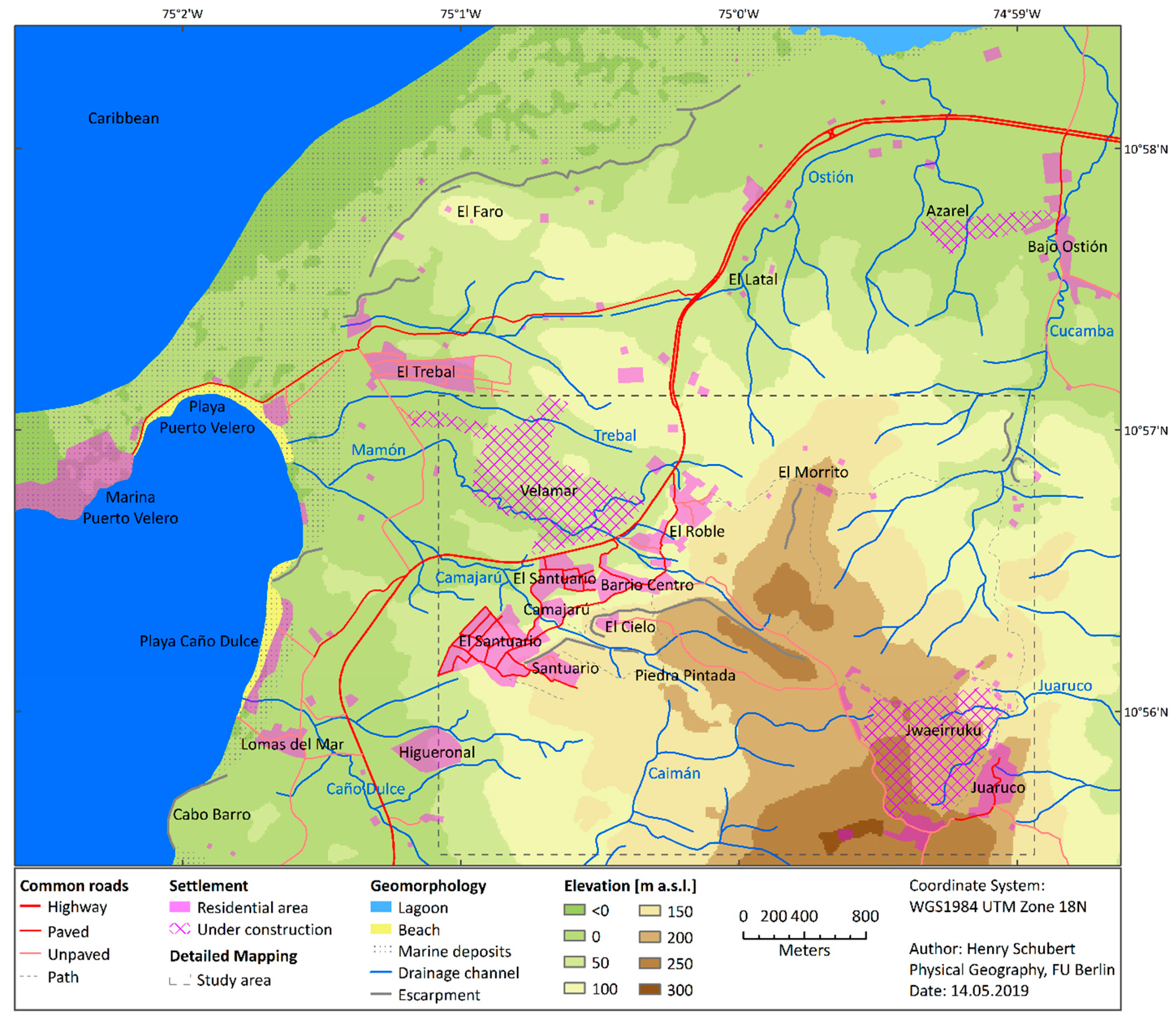
2. Study Area
3. Methods
3.1. Combatibility of Methods
3.2. Land Use Mapping and Spatial Statistical Analysis
3.3. Participatory Methods
4. Results
4.1. Land Use Mapping and Spatial Statistical Analysis
4.2. Perception of the Residents
The roads have brought development, but fauna and flora are lost (...). [Before 1982] the routes from Puerto Colombia were paths, bridle paths; transport worked by donkey or mule along these paths or along the beach shore (…). It was an area where there was no development like today; we had to follow the development (…). It is development as they say, but they have also destroyed green areas, forest areas, trees, and crops (...).
[The area is being] affected by urbanization [gated community] projects, illegal hunting (...), and because now most of the land belongs to private companies, which are not interested in preserving nature. Around these urban developers, wildlife, fishing, and the «bareque» houses [traditional construction based on wood and mud] are lost, which are now made of material [meaning modern construction materials] (...).
There was a larger amount of [wild] animals such as the howler monkey [Alouatta seniculus], the «guacamaya» [genus Ara], and the «guacharaca» [Ortalis ruficauda]. They are still here, but before there were more (...).
5. Discussion
5.1. Limits of Land Use Mapping and Spatial Statistical Analysis
5.2. Limits of Participatory Methods
5.3. Alignment of Scientific and Participatory Mapping
6. Conclusions
Supplementary Materials
Author Contributions
Funding
Acknowledgments
Conflicts of Interest
References
- Lambin, E.F.; Turner, B.L.; Geist, H.J.; Agbola, S.B.; Angelsen, A.; Bruce, J.W.; Coomes, O.T.; Dirzo, R.; Fischer, G.; Folke, C.; et al. The causes of land-use and land-cover change: Moving beyond the myths. Glob. Environ. Chang. 2001, 11, 261–269. [Google Scholar] [CrossRef]
- DeFries, R.S.; Asner, G.P.; Houghton, R. Trade-Offs in Land-Use Decisions: Towards a Framework for Assessing Multiple Ecosystem Responses to Land-Use Change. In Geophysical Monograph Series; DeFries, R.S., Asner, G.P., Houghton, R.A., Eds.; American Geophysical Union: Washington, DC, USA, 2004; Volume 153, pp. 1–9. ISBN 978-0-87590-418-4. [Google Scholar]
- Sharma, R.; Nguyen, T.; Grote, U. Changing Consumption Patterns—Drivers and the Environmental Impact. Sustainability 2018, 10, 4190. [Google Scholar] [CrossRef]
- Laurance, W.F. Rapid Land-Use Change and its Impacts on Tropical Biodiversity. In Geophysical Monograph Series; DeFries, R.S., Asner, G.P., Houghton, R.A., Eds.; American Geophysical Union: Washington, DC, USA, 2004; Volume 153, pp. 189–199. ISBN 978-0-87590-418-4. [Google Scholar]
- Foley, J.A.; DeFries, R.; Asner, G.P.; Barford, C.; Bonan, G.; Carpenter, S.R.; Chapin, F.S.; Coe, M.T.; Daily, G.C.; Gibbs, H.K. Global Consequences of Land Use. Science 2005, 309, 570–574. [Google Scholar] [CrossRef]
- Lambin, E.F.; Geist, H.J.; Lepers, E. Dynamics of land-use and land-cover change in tropical regions. Annu. Rev. Environ. Resour. 2003, 28, 205–241. [Google Scholar] [CrossRef]
- Aldana-Domínguez, J.; Montes, C.; González, J. Understanding the Past to Envision a Sustainable Future: A Social–Ecological History of the Barranquilla Metropolitan Area (Colombia). Sustainability 2018, 10, 2247. [Google Scholar] [CrossRef]
- Schubert, H.; Caballero Calvo, A.; Rauchecker, M.; Rojas-Zamora, O.; Brokamp, G.; Schütt, B. Assessment of Land Cover Changes in the Hinterland of Barranquilla (Colombia) Using Landsat Imagery and Logistic Regression. Land 2018, 7, 152. [Google Scholar] [CrossRef]
- Zaehringer, J.G.; Llopis, J.C.; Latthachack, P.; Thein, T.T.; Heinimann, A. A novel participatory and remote-Sensing-Based approach to mapping annual land use change on forest frontiers in Laos, Myanmar, and Madagascar. J. Land Use Sci. 2018, 13, 16–31. [Google Scholar] [CrossRef]
- Belisle, F.J.; Hoy, D.R. The perceived impact of tourism by residents a case study in Santa Marta, Colombia. Ann. Tour. Res. 1980, 7, 83–101. [Google Scholar] [CrossRef]
- Andereck, K.L.; Valentine, K.M.; Knopf, R.C.; Vogt, C.A. Residents’ perceptions of community tourism impacts. Ann. Tour. Res. 2005, 32, 1056–1076. [Google Scholar] [CrossRef]
- Wang, Y.; Pfister, R.E. Residents’ Attitudes Toward Tourism and Perceived Personal Benefits in a Rural Community. J. Travel Res. 2008, 47, 84–93. [Google Scholar] [CrossRef]
- Portillo-Quintero, C.; Sánchez-Azofeifa, A.; Calvo-Alvarado, J.; Quesada, M.; Do Espirito Santo, M.M. The role of tropical dry forests for biodiversity, carbon and water conservation in the neotropics: Lessons learned and opportunities for its sustainable management. Reg. Environ. Chang. 2015, 15, 1039–1049. [Google Scholar] [CrossRef]
- Bastin, J.F.; Berrahmouni, N.; Grainger, A.; Maniatis, D.; Mollicone, D.; Moore, R.; Patriarca, C.; Picard, N.; Sparrow, B.; Abraham, E.M.; et al. The extent of forest in dryland biomes. Science 2017, 356, 635–638. [Google Scholar] [CrossRef] [PubMed]
- Portillo-Quintero, C.; Sánchez-Azofeifa, A. Extent and conservation of tropical dry forests in the Americas. Biol. Conserv. 2010, 143, 144–155. [Google Scholar] [CrossRef]
- García, H.; Corzo, G.; Isaacs, P.; Etter, A. Distribución y Estado Actual de los Remanentes del Bioma de Bosque Seco Tropical en Colombia: Insumos Para su gestión. In El Bosque Seco Tropical en Colombia; Pizano, C., García, H., Eds.; Instituto de Investigación de Recursos Biológicos Alexander von Humboldt (IAvH): Bogotá, Colombia, 2014; pp. 229–251. ISBN 978-958-8343-97-6. [Google Scholar]
- González-M, R.; García, H.; Isaacs, P.; Cuadros, H.; López-Camacho, R.; Rodríguez, N.; Pérez, K.; Mijares, F.; Castaño-Naranjo, A.; Jurado, R.; et al. Disentangling the environmental heterogeneity, floristic distinctiveness and current threats of tropical dry forests in Colombia. Environ. Res. Lett. 2018, 13, 045007. [Google Scholar]
- Rodríguez, G.M.; Banda, K.; Reyes, S.P.; González, A.C.E. Lista comentada de las plantas vasculares de bosques secos prioritarios para la conservación en los departamentos de Atlántico y Bolívar (Caribe colombiano). Biota Colomb. 2012, 13, 7–39. [Google Scholar]
- Lücking, R.; Moncada, B.; Martínez-Habibe, M.C.; Salgado-Negret, B.E.; Celis, M.; Rojas-Zamora, O.; Rodríguez-M, G.M.; Brokamp, G.; Borsch, T. Lichen diversity in colombian caribbean dry forest remnants. Caldasia 2019, 41, 194–214. [Google Scholar]
- Rozendaal, D.M.A.; Bongers, F.; Aide, T.M.; Alvarez-Dávila, E.; Ascarrunz, N.; Balvanera, P.; Becknell, J.M.; Bentos, T.V.; Brancalion, P.H.S.; Cabral, G.A.L.; et al. Biodiversity recovery of Neotropical secondary forests. Sci. Adv. 2019, 5, eaau3114. [Google Scholar] [CrossRef]
- Dunn, C.E. Participatory GIS—A people’s GIS? Prog. Hum. Geogr. 2007, 31, 616–637. [Google Scholar] [CrossRef]
- Kremen, C.; Merenlender, A.M. Landscapes that work for biodiversity and people. Science 2018, 362, eaau6020. [Google Scholar] [CrossRef]
- Munthali, M.G.; Davis, N.; Adeola, A.M.; Botai, J.O.; Kamwi, J.M.; Chisale, H.L.W.; Orimoogunje, O.O.I. Local Perception of Drivers of Land-Use and Land-Cover Change Dynamics across Dedza District, Central Malawi Region. Sustainability 2019, 11, 832. [Google Scholar] [CrossRef]
- Mapedza, E.; Wright, J.; Fawcett, R. An investigation of land cover change in Mafungautsi Forest, Zimbabwe, using GIS and participatory mapping. Appl. Geogr. 2003, 23, 1–21. [Google Scholar] [CrossRef]
- Ramirez-Gomez, S.O.I.; Torres-Vitolas, C.A.; Schreckenberg, K.; Honzák, M.; Cruz-Garcia, G.S.; Willcock, S.; Palacios, E.; Pérez-Miñana, E.; Verweij, P.A.; Poppy, G.M. Analysis of ecosystem services provision in the Colombian Amazon using participatory research and mapping techniques. Ecosyst. Serv. 2015, 13, 93–107. [Google Scholar] [CrossRef]
- Brown, G.; Strickland-Munro, J.; Kobryn, H.; Moore, S.A. Mixed methods participatory GIS: An evaluation of the validity of qualitative and quantitative mapping methods. Appl. Geogr. 2017, 79, 153–166. [Google Scholar] [CrossRef]
- Chambers, R. The origins and practice of participatory rural appraisal. World Dev. 1994, 22, 953–969. [Google Scholar] [CrossRef]
- McCall, M.K.; Minang, P.A. Assessing participatory GIS for community-based natural resource management: Claiming community forests in Cameroon. Geogr. J. 2005, 171, 340–356. [Google Scholar] [CrossRef]
- Lynch, K. The Image of the City; Publication of the Joint Center for Urban Studies; Reprint; MIT PRESS: Cambridge, MA, USA, 2005; ISBN 978-0-262-62001-7. [Google Scholar]
- Stevens, Q. The Shape of Urban Experience: A Reevaluation of Lynch’s Five Elements. Environ. Plan. B Plan. Des. 2006, 33, 803–823. [Google Scholar] [CrossRef]
- Sletto, B.I. “We Drew What We Imagined”: Participatory Mapping, Performance, and the Arts of Landscape Making. Curr. Anthropol. 2009, 50, 443–476. [Google Scholar] [CrossRef]
- Robinson, C.J.; Maclean, K.; Hill, R.; Bock, E.; Rist, P. Participatory mapping to negotiate indigenous knowledge used to assess environmental risk. Sustain. Sci. 2016, 11, 115–126. [Google Scholar] [CrossRef]
- Consorcio Via al Mar. Proyectos. Available online: http://www.consorcioviaalmar.co/proyectos.html (accessed on 13 June 2019).
- Concejo Municipal Tubará. Acuerdo No. 003 de Marzo 15 del 2013; Tubará: Atlántico, Colombia, 2013.
- Alaska Satellite Facility. ALOS PALSAR-Terrain-Corrected (RTC). Available online: https://www.asf.alaska.edu/sar-data/palsar/terrain-corrected-rtc/ (accessed on 7 May 2019).
- Geofabrik GmbH and OpenStreetMap Contributors. Colombia. Available online: http://download.geofabrik.de/south-america/colombia.html (accessed on 5 November 2018).
- Instituto Geográfico Agustín Codazzi (IGAC). Datos Abiertos Cartografía y Geografía - Cartografía Base Escala 1:25.000. Available online: https://geoportal.igac.gov.co/es/contenido/datos-abiertos-cartografia-y-geografia (accessed on 5 November 2018).
- El Poblado, S.A. Proyectos-Complejo Campestre Jwaeirruku. Available online: https://elpobladosa.com/complejo-campestre-jwaeirruku/ (accessed on 14 May 2019).
- El Poblado, S.A. Proyectos-Reserva Campestre Velamar. Available online: https://elpobladosa.com/reserva-campestre-velamar/ (accessed on 14 May 2019).
- Zapata, G.; Reyes, G.; Barrera, R. Geología del Departamento de Atlántico (Map); INGEOMINAS: Bogotá, Colombia, 1999.
- Instituto Geográfico Agustín Codazzi (IGAC). Estudio General de Suelos y Zonificación de Tierras: Departamento del Atlántico; Imprenta Nacional de Colombia: Bogotá, Colombia, 2008; ISBN 978-958-8323-20-6.
- Fick, S.E.; Hijmans, R.J. WorldClim 2: New 1-Km spatial resolution climate surfaces for global land areas. Int. J. Climatol. 2017, 37, 4302–4315. [Google Scholar] [CrossRef]
- Departamento Administrativo Nacional de Estadística (DANE). Censo General 2005. Available online: https://www.dane.gov.co/index.php/estadisticas-por-tema/demografia-y-poblacion/censo-general-2005-1 (accessed on 26 April 2019).
- Departamento Nacional de Planeación (DNP). Terridata-Tubará, Atlántico. Available online: https://terridata.dnp.gov.co/#/perfiles/08832 (accessed on 26 April 2019).
- Blanco Barros, J.A. Tubará: La Encomienda Mayor de Tierradentro. Obras Completas, Tomo III, 1st ed.; Donoso, J.V., Lugo, A.V., Eds.; Editorial Universidad del Norte: Barranquilla, Colombia, 2015; ISBN 978-958-741-568-1. [Google Scholar]
- Community Leader A, Former Representative of the Indigenous Community. Interview by Markus Rauchecker and Henry Schubert. Semi-Structured Interview. Tubará, Colombia, 17 November 2017, 4 and 9 May 2018 (unpublished).
- Concejo Municipal de Tubará. Acuerdo No. 013 del 1995; Tubará: Atlántico, Colombia, 1995.
- Taborda, A.; García Quiñones, M.E.; Pino Renjifo, J.; Posada Martínez, J.C.; Sandobal Rojano, A.M. Areas Potenciales Para la Conservación en el Atlantico: Herramienta de Conservación y Construcción de Territorio en el Departamento del Atlántico; CRA: Barranquilla, Colombia, 2008; ISBN 978-958-98915-0-6.
- Community Leader B, Representative of the Community Aqueduct. Interview by Markus Rauchecker. Semi-Structured Interview. Tubará, Colombia, 9 May 2018, 26 June 2018 (unpublished).
- Agencia Nacional de Minería (ANM). Resolución No. VSC 000989 de 2014. Available online: https://www.anm.gov.co/sites/default/files/atencion_minero/liberacion_de_area.pdf (accessed on 22 July 2019).
- Instituto Geográfico Agustín Codazzi (IGAC). Information about land prices of parcels of 2010 and 2017 located in El Morro and Juaruco. 2019; Unpublished raw data. [Google Scholar]
- Secretaría de Planeación del Atlántico. Evaluaciones Agropecuarias Anuales del Departamento Atlántico. Available online: http://www.atlantico.gov.co/index.php/anuarios-estadisticos (accessed on 16 May 2018).
- Instituto Colombiano Agropecuario (ICA). Censo Pecuario Nacional 2017. Available online: https://www.ica.gov.co/Areas/Pecuaria/Servicios/Epidemiologia-Veterinaria/Censos-2016/Censo-2017.aspx (accessed on 17 January 2018).
- Community Leader C, Former Municipal Councilor. Interview by Markus Rauchecker and Henry Schubert. Semi-Structured Interview. Tubará, Colombia, 28 and 31 October 2017, 17 November 2017, 2 and 9 May 2018 (unpublished).
- Gobernación del Atlántico. #AtlánticoLiderEnObras: Nuevo Acueducto de El Morro, un Impulso al Desarrollo Turistico Costero. Available online: http://www.atlantico.gov.co/index.php/noticias-agua-potable-26686/11830-atlanticoliderenobras-nuevo-acueducto-de-el-morro-un-impulso-al-desarrollo-turistico-costero (accessed on 18 June 2019).
- Crampton, J.W. Cartography: Performative, participatory, political. Prog. Hum. Geogr. 2009, 33, 840–848. [Google Scholar] [CrossRef]
- Whitehead, M.; Jones, R.; Jones, M. The Nature of the State: Excavating the Political Ecologies of the Modern State; Oxford Geographical and Environmental Studies; Oxford University Press: Oxford, NY, USA, 2007; ISBN 978-0-19-927189-4. [Google Scholar]
- Antrop, M.; Van Eetvelde, V. Holistic aspects of suburban landscapes: Visual image interpretation and landscape metrics. Landsc. Urban Plan. 2000, 50, 43–58. [Google Scholar] [CrossRef]
- Svatonova, H. Analysis of visual interpretation of satellite data. ISPRS Int. Arch. Photogramm. Remote Sens. Spat. Inf. Sci. 2016, 41, 675–681. [Google Scholar] [CrossRef]
- ESRI. ArcGIS Pro Help-Overview of Georeferencing. Available online: https://pro.arcgis.com/en/pro-app/help/data/imagery/overview-of-georeferencing.htm (accessed on 26 April 2019).
- Robbins, P. Beyond Ground Truth: GIS and the Environmental Knowledge of Herders, Professional Foresters, and Other Traditional Communities. Hum. Ecol. 2003, 31, 233–253. [Google Scholar] [CrossRef]
- Anaya, J.; Colditz, R.; Valencia, G. Land Cover Mapping of a Tropical Region by Integrating Multi-Year Data into an Annual Time Series. Remote Sens. 2015, 7, 16274–16292. [Google Scholar] [CrossRef]
- Pagiola, S.; Honey-Rosés, J.; Freire-González, J. Evaluation of the Permanence of Land Use Change Induced by Payments for Environmental Services in Quindío, Colombia. PLoS ONE 2016, 11, e0147829. [Google Scholar] [CrossRef]
- Hijmans, R.J. Raster: Geographic Data Analysis and Modeling. R Package Version 2.8-19. Available online: https://CRAN.R-project.org/package=raster 2019 (accessed on 26 April 2019).
- Community Leader D. Interview by Markus Rauchecker and Henry Schubert. Semi-Structured Interview. Tubará, Colombia, 30 June 2018 (unpublished).
- Community Leader E, Representative of the Beach Huts. Interview by Markus Rauchecker. Semi-structured interview. Tubará, Colombia, 31 October 2017 (unpublished).
- Community leader F, Representative of the Local Authority. Interview by Markus Rauchecker. Semi-Structured Interview. Tubará, Colombia, 2 May 2018 (unpublished).
- Yin, R.K. Case Study Research: Design and Methods, 4th ed.; Applied social Research Methods; Sage Publications: Los Angeles, CA, USA, 2009; ISBN 978-1-4129-6099-1. [Google Scholar]
- Hessel, R.; Van Den Berg, J.; Kabore, O.; Van Kekem, A.; Verzandvoort, S.; Dipama, J.M.; Diallo, B. Linking participatory and GIS-based land use planning methods: A case study from Burkina Faso. Land Use Policy 2009, 26, 1162–1172. [Google Scholar] [CrossRef]
- Mayring, P. Qualitative Inhaltsanalyse. In Handbuch Qualitative Forschung in der Psychologie; Mey, G., Mruck, K., Eds.; VS Verlag für Sozialwissenschaften: Wiesbaden, Germany, 2010; pp. 601–613. ISBN 978-3-531-92052-8. [Google Scholar]
- Buzinde, C.N.; Manuel-Navarrete, D. The social production of space in tourism enclaves: Mayan children’s perception of tourism boundaries. Ann. Tour. Res. 2013, 43, 482–505. [Google Scholar] [CrossRef]
- Departamento Nacional de Planeación (DNP). Decreto No. 2204 de 2017. Available online: http://es.presidencia.gov.co/normativa/normativa/DECRETO%202204%20DEL%2026%20DE%20DICIEMBRE%20DE%202017.pdf (accessed on 13 June 2019).
- Departamento Nacional de Planeación (DNP). Decreto No. 2456 de 2018. Available online: http://es.presidencia.gov.co/normativa/normativa/DECRETO%202456%20DEL%2027%20DE%20DICIEMBRE%20DE%202018.pdf (accessed on 13 June 2019).
- Kalacska, M.; Sanchez-Azofeifa, G.A.; Rivard, B.; Caelli, T.; White, H.P.; Calvo-Alvarado, J.C. Ecological fingerprinting of ecosystem succession: Estimating secondary tropical dry forest structure and diversity using imaging spectroscopy. Remote Sens. Environ. 2007, 108, 82–96. [Google Scholar] [CrossRef]
- Kwaku Kyem, P.A. Of Intractable Conflicts and Participatory GIS Applications: The Search for Consensus amidst Competing Claims and Institutional Demands. Ann. Assoc. Am. Geogr. 2004, 94, 37–57. [Google Scholar] [CrossRef]
- Corte Constitucional de la República de Colombia. Ruling T-011/19 from 22 January 2019. Available online: http://www.corteconstitucional.gov.co/relatoria/2019/t-011-19.htm (accessed on 21 October 2019).
- Phillips, M.; Smith, D.P. Comparative approaches to gentrification: Lessons from the rural. Dialogues Hum. Geogr. 2018, 8, 3–25. [Google Scholar] [CrossRef]
- Yang, D.; Kanae, S.; Oki, T.; Koike, T.; Musiake, K. Global potential soil erosion with reference to land use and climate changes. Hydrol. Process. 2003, 17, 2913–2928. [Google Scholar] [CrossRef]
- Borrelli, P.; Schütt, B. Assessment of soil erosion sensitivity and post-timber-harvesting erosion response in a mountain environment of Central Italy. Geomorphology 2014, 204, 412–424. [Google Scholar] [CrossRef]
- Sánchez-Cuervo, A.M.; Aide, T.M.; Clark, M.L.; Etter, A. Land Cover Change in Colombia: Surprising Forest Recovery Trends between 2001 and 2010. PLoS ONE 2012, 7, e43943. [Google Scholar] [CrossRef] [PubMed]
- Wei, Y.P.; Chen, D.; White, R.E.; Willett, I.R.; Edis, R.; Langford, J. Farmers’ perception of environmental degradation and their adoption of improved management practices in Alxa, China. Land Degrad. Dev. 2009, 20, 336–346. [Google Scholar] [CrossRef]
- Swierk, L.; Madigosky, S.R. Environmental Perceptions and Resource use in Rural Communities of the Peruvian Amazon (Iquitos and Vicinity, Maynas Province). Trop. Conserv. Sci. 2014, 7, 382–402. [Google Scholar] [CrossRef]


| Sensor | Date | Spatial Resolution | Number of Bands |
|---|---|---|---|
| QuickBird-2 | 22 Mar 2008 | 2 m | 4 |
| WorldView-2 | 24 Dec 2011 | 2 m | 8 |
| GeoEye-1 | 21 Dec 2013 | 2 m | 4 |
| GeoEye-1 | 05 Apr 2017 | 2 m | 4 |
| ID | Class | Subclasses and Definition |
|---|---|---|
| 10 | Settlement | Paved roads (ID 11); religious, educational, health, and supply facilities (ID 12); residential area and buildings with home gardens (ID 13) |
| 20 | Bare Soil | Paths, unpaved roads, and soccer fields (ID 21); absence of topsoil due to construction activities (ID 22) or due to gravitational mass movements (ID 23) |
| 30 | Cleared | Agricultural land with mainly mixed crops and burned areas prepared for agriculture (ID 31); areas with no or only individual trees used as pastures (ID 32); grass strips and cleared areas, which are cleared or kept free for construction activities (ID 33); barren land, degraded areas, and open areas with pioneer vegetation recovery (ID 34) |
| 40 | Woody vegetation | Wooded areas dominated by younger trees or visible degradation (ID 41); forests with closed canopy (ID 42); riparian forests along the drainage channels (ID 43) |
| 50 | Water | Used and abandoned ponds for livestock (ID 50) |
| ID | Class | Area in Hectares | Change 2008–2017/18 [%] | |||
|---|---|---|---|---|---|---|
| 2008 | 2011 | 2013 | 2017/18 | |||
| 10 | Settlement | 52.78 | 60.02 | 61.58 | 65.53 | 24.2 |
| 11 | Paved roads | 5.68 | 6.14 | 6.71 | 7.73 | 36.1 |
| 12 | Community facilities | 5.23 | 5.44 | 5.44 | 5.44 | 4.0 |
| 13 | Residential areas | 41.87 | 48.44 | 49.43 | 52.36 | 25.1 |
| 20 | Bare soil | 15.86 | 17.54 | 18.12 | 80.47 | 407.4 |
| 21 | Paths | 9.92 | 9.73 | 9.33 | 8.57 | –13.6 |
| 22 | Construction | 3.33 | 3.43 | 5.52 | 68.76 | 1964.9 |
| 23 | Landslides | 2.61 | 4.38 | 3.27 | 3.14 | 20.3 |
| 30 | Cleared | 191.02 | 179.49 | 221.08 | 221.20 | 15.8 |
| 31 | Fields | 32.45 | 23.33 | 19.47 | 17.58 | –45.8 |
| 32 | Pastures | 64.11 | 73.25 | 69.81 | 74.72 | 16.6 |
| 33 | Construction | 17.77 | 16.79 | 48.61 | 55.47 | 212.2 |
| 34 | other | 76.69 | 66.12 | 83.19 | 73.43 | –4.3 |
| 40 | Woody vegetation | 909.48 | 911.85 | 868.11 | 801.70 | –11.9 |
| 41 | Young forests | 293.84 | 345.38 | 307.46 | 256.20 | –12.8 |
| 42 | Closed forests | 550.62 | 501.47 | 495.62 | 481.36 | –12.6 |
| 43 | Riparian forests | 65.02 | 65.00 | 65.03 | 64.14 | –1.4 |
| 50 | Water | 0.86 | 1.10 | 1.11 | 1.10 | 27.9 |
© 2019 by the authors. Licensee MDPI, Basel, Switzerland. This article is an open access article distributed under the terms and conditions of the Creative Commons Attribution (CC BY) license (http://creativecommons.org/licenses/by/4.0/).
Share and Cite
Schubert, H.; Rauchecker, M.; Caballero Calvo, A.; Schütt, B. Land Use Changes and Their Perception in the Hinterland of Barranquilla, Colombian Caribbean. Sustainability 2019, 11, 6729. https://doi.org/10.3390/su11236729
Schubert H, Rauchecker M, Caballero Calvo A, Schütt B. Land Use Changes and Their Perception in the Hinterland of Barranquilla, Colombian Caribbean. Sustainability. 2019; 11(23):6729. https://doi.org/10.3390/su11236729
Chicago/Turabian StyleSchubert, Henry, Markus Rauchecker, Andrés Caballero Calvo, and Brigitta Schütt. 2019. "Land Use Changes and Their Perception in the Hinterland of Barranquilla, Colombian Caribbean" Sustainability 11, no. 23: 6729. https://doi.org/10.3390/su11236729
APA StyleSchubert, H., Rauchecker, M., Caballero Calvo, A., & Schütt, B. (2019). Land Use Changes and Their Perception in the Hinterland of Barranquilla, Colombian Caribbean. Sustainability, 11(23), 6729. https://doi.org/10.3390/su11236729