Article

The Impacts of Human Activities on Ecosystems within China’s Nature Reserves

1
Key Laboratory of Land Surface Pattern and Simulation, Institute of Geographic Sciences and Natural Resources Research, CAS, Beijing 100101, China
2
University of Chinese Academy of Sciences, Beijing 100049, China
3
Satellite Environment Center, Ministry of Ecology and Environment of the People’s Republic of China, Beijing 100094, China
*
Author to whom correspondence should be addressed.
Sustainability 2019, 11(23), 6629; https://doi.org/10.3390/su11236629
Submission received: 7 September 2019 / Revised: 10 November 2019 / Accepted: 15 November 2019 / Published: 23 November 2019
(This article belongs to the Special Issue National Parks: Theories and Practices)

Abstract

:
Protected areas (PAs) provide refuges for threatened species and are considered to be the most important approach to biodiversity conservation. Besides climate change, increasing human population is the biggest threat to biodiversity and habitats in PAs. In this paper, the temporal and spatial variations of land cover changes (LCC), vegetation fraction (VFC), and net primary productivity (NPP) were studied to present the ecosystem dynamics of habitats in 6 different types of national nature reserves (NNRs) in 8 climate zones in China. Furthermore, we used Defense Meteorological Satellite Program/Operational Linescan System (DMSP/OLS) nighttime light datasets and the human disturbance (HD) index estimated from LCC to quantify the living and developing human pressures within the NNRs in the period 2000–2013. The results showed that (1) the living human activities of NNRs increased apparently in the humid warm-temperate zone, Qinghai-Tibet Plateau, mid-temperate semi-arid zone, and mid-temperate humid zone, with the highest increase of nighttime light observed in inland wetlands; (2) the developing human activities in NNRs indicated by the HD index were higher in the humid warm-temperate zone and mid-temperate semi-arid zone as a result of increasing areas of agricultural and built activities, and lower in the sub-tropics due to improved conservation of forest ecosystems; (3) the relationship between HD and VFC suggests that ecosystems in most NNRs of south-subtropics, mid-temperate arid zone and Qinghai-Tibet Plateau were predominantly impacted by climate change. However, HDs were the prevalent factor of ecosystem dynamics in most NNRs of north-subtropics, mid-temperate semi-arid and humid zones.

1. Introduction

More than 85% of the vulnerable or endangered species are influenced by the degradation or destruction of habitat, and at least 20% are impacted by severe weather conditions and climate change in terrestrial ecosystems [1,2]. Protected areas (PAs) are identified as the most important units for preservation in situ [3]. With increasing human activity pressure on the earth’s resources, an effective PAs system is one of the most important approaches for the protection of biodiversity [4,5,6], or slowing the loss rate with its value from a social perspective is changing due to a constantly changing society [7]. As an increasing trend in conservation, research about PAs have become increasingly more important [8].
The validity of PAs increasingly threatened by human activities and climate change. However, the extend of this threat is not clear. In the last few years, there have been some debates on its validity [9,10]. In the context of climate change, the advantages of PAs have been questioned for biodiversity because PAs are motionless static, whereas the distributions of plant and animal species are dynamic [11]. Climate change and land cover changes (LCC) both impress vegetation-structural properties in terrestrial ecosystems [12]. Past research has mainly concentrated on the effect of climate change [13,14,15]. Compared with studies which focused on the impact of climate change, the number of studies which concentrate on expected influence of future LCC on biodiversity falls far behind [2].
In addition, the decline of biodiversity is affected by types of human drivers, including LCC, invasive species, overexploitation, and pollution [1,16]. The most immediate and significant threats to biodiversity are direct degradation and destruction of habitats caused by LCC [2]. Threatening up to 44.8% of vertebrate populations [17], whereas climate change only is a threat to 7.1% of the extinction of vertebrates. Road construction, real estate development, and urbanization affect negatively reserves and reduce the effective extent of reserves [18,19]. Concern that some PAs might be “paper parks” which hardly come sustainable protection [20,21].
National nature reserves (NNRs) are the most strictly managed type of PAs, which limit or even forbid human activities within their boundaries. China’s environmental bulletin of 2015 suggest that China established 2740 nature reserves with area of 1.47 million km2 totally which cover 14.8% of China’s territory as of 2015, and China strives to take 20% of its land under protection by 2020. It is necessary to understand the dynamics of habitat in NNRs and analyze the impacts of increasing human activities on the habitat with the changing climate. However, national-scale assessments of habitat and ecosystems in NNRs is lacking. Choosing typical NNRs as research areas, this study analyzed the temporal and spatial variations of LCC, vegetation fraction (VFC) and net primary productivity (NPP) based on model simulation, remote sensing inversion and spatial analysis methods, to present the habitat ecosystem dynamics of NNRs in varied climate zones. We also used Defense Meteorological Satellite Program/Operational Linescan System (DMSP/OLS) nighttime light data which can detect small plot of residential land and human disturbances (HD), which means the degree of surface change to quantitive human activities in NNRs. Then HD and its relationship with VFC was comprehensively discussed to recognize the impact of human activities. The study aimed to discriminate the negative and positive impacts of human activities on habitat in China’s typical NNRs over the past few decades and to assess the effects of the most strictly managed PAs in conserving habitat.

2. Methods and Materials

2.1. Study Areas

Until 2015, China had established 428 national nature reserves (NNRs). This research chose 299 NNRs, the boundary of which is getatable as study areas. And aquatic animal and sea coast NNRs were not considered. These 299 NNRs include 167 forest ecosystems, 4 grassland meadows, 36 inland wetlands, 13 desert ecosystems, 67 wild plants, and 13 wild animals NNRs. We obtained the boundaries of study areas from Ministry of Ecology and Environment of the People’s Republic of China (http://www.zhb.gov.cn/stbh/zrbhq/gjjzrbhqps/). The NNRs were vectored by combining them with high-resolution and topography remote sensing images. In addition, we classified China into 8 climate zones [22] (Figure 1). Among these NNRs, 22 are located in south-subtropics, 102 in middle-subtropics, 30 in north-subtropics, 11 in humid warm-temperate zone, 38 in Qinghai-Tibetan Plateau, 42 in mid-temperate humid zone, 35 in mid-temperate semi-arid zone, and 19 in mid-temperate arid zone.

2.2. The Land Cover Change Datasets

LCC datasets were collected for the years of 2000, 2005, 2010, and 2015 with resolution of 100 m from Data Center for Resources and Environmental Sciences, Chinese Academy of Sciences (http://www.resdc.cn). These datasets were interpreted by human-machine interactions based on rectified satellite images using an ArcGIS platform, according to methods from Liu et al. [23]. Land cover was classified into 6 primary types, consisting of grassland, forest, cropland, wetland, desert, and built area. The 6 types were further subdivided into 25 subtypes.

2.3. Quantitative Methods of Human Activities

We divided human activities into living activities and developing activities. We used DMSP/OLS as nighttime light datato response the living activities in NNRs, which is a value of average light intensity from 20:30 to 21:30, acquired by sensor of Operational Linescan System carried by Defense Meteorological Satellite Program (DMSP). The nighttime light dataset can be used to detect low-intensity light emitted by urban lights, small-scale residential areas, and traffic flow [24]. We downloaded DMSP/OLS nighttime light data at National Geophysical Data Center (http://www.ngdc.noaa.gov/dmsp/download.html), with a value range from 0 to 63.
In addition, the HD induced from LCC was estimated and analyzed to respond the developing activities in agricultural and urbanization, based on 25 subtypes of the LCC datasets for 2000, 2005, 2010 and 2015. HD is defined as an index to quantify the degree of resource utilization, environmental development, and reformation of nature in a certain region, which are reflected by LCC. It can be calculated as follows:
HD = S C L E S × 100 %
S C L E = i = 1 n S L i · C I i
where S C L E is area of equivalent construction area; S is areas totally; S L i is area of landuse type i , i =1, 2,..., n; C I i is a conversion factor (Table 1), which was used to compare the different degrees of human activities on the land surface, and its value was defined by referring to Zhao et al., Xu et al. and Zhu et al. [25,26,27].

2.4. Estimation of Ecosystem Qualities

2.4.1. The Calculation of Vegetation Fraction

The data of vegetation fraction (VFC) was derived from the Normalized Difference Vegetation Index (NDVI) by model of dimidiate pixel [28], as a pixel of NDVI data could allow extraction of the non-vegetation and green vegetation information. VFC from 2000 to 2015 was calculated by follow equation:
VFC = N D V I N D V I m i n N D V I m a x N D V I m i n
In which, NDVImax is the value of totally pure vegetation and NDVImin is the value of barely land without vegetation. MODIS NDVI for 16-day intervals from 2000 to 2015 was collected, and annual NDVI values were calculated by maximum value.

2.4.2. Model Simulation of Net Primary Production (NPP)

NPP is a significant indicator in measuring ecosystem condition [29,30,31]. In recent years, the model simulation of NPP based on remote sensing has led to extensive application in assessing vegetation ecosystem changes on a large scale [32,33]. The simulation of NPP with a continuous time sequence and spatial attributes provides a data basis for the quantitative evaluation of the protection of a nature reserve [34].
We used Global Production Efficiency Model (GLO-PEM) to simulate NPP. GLOPEM uses satellite variables that include linked components expressing canopy radiation absorption, autotrophic respiration, utilization, and other environmental factors [35,36]. To begin with, vegetation gross primary productivity (GPP) was estimated as follows:
GPP = PAR · FPAR · ε g
ε g = ε g * · σ
In which, PAR is photosynthetic active radiation, calculated by Allen et al. [37]. FPAR is fraction of absorbed active radiation photosynthetically. FPAR was inverted by canopy radiative transfer algorithm, which was exploited by Liu et al. [38] on the basis of the NDVI. ε g is efficiency of solar energy utilization. ε g * is the potential maximum radiation energy utilization under ideal conditions. σ is the impact on the environment including water pressure deficit, PAR, temperature, CO2, and soil moisture [39,40]. Meteorological data was acquired from China Meteorological Administration (http://data.cma.cn) and then interpolated using ANUSPLIN.
NPP is the subtraction of the GPP and autotrophic respiration (Ra). It was modeled with 1 km spatial resolution from 2000 to 2015 for NNRs in China by following equation:
R a = f ( R m ) + R g
NPP = GPP R a
where R g is growing respiration and R m is maintenance respiration.

2.5. Analysis and Assessment Methods

The temporal and spatial change pattern of LCC, VFC, NPP and HD from 2000 to 2015 were analyzed for different type of NNRs in varied climate zones to assess the habitat dynamics of a recent 15-year period.
First, the change area and proportion of cropland, forest, grassland, wetland, built area, and desert for 2000, 2005, 2010 and 2015 were statistically analyzed. Then, we calculated HD for each NNR and grouped by NNR type and climate zones, and analyzed the 5-year changes. Following the change patterns of VFC and NPP, we present the ecosystem qualities and changes in the NNRs.
The temporal variation trends ( s l o ) were tested by method of the least squares as follows:
s l o = n × i = 1 n ( i × I ) i = 1 n i i = 1 n M n × i = 1 n i 2 ( i = 1 n i ) 2
where i is the serial number from 2000 to 2015 and M is the indicator value of VFC or NPP. If the value of s l o is positive, the trend of change is increased; conversely, it is decreased.
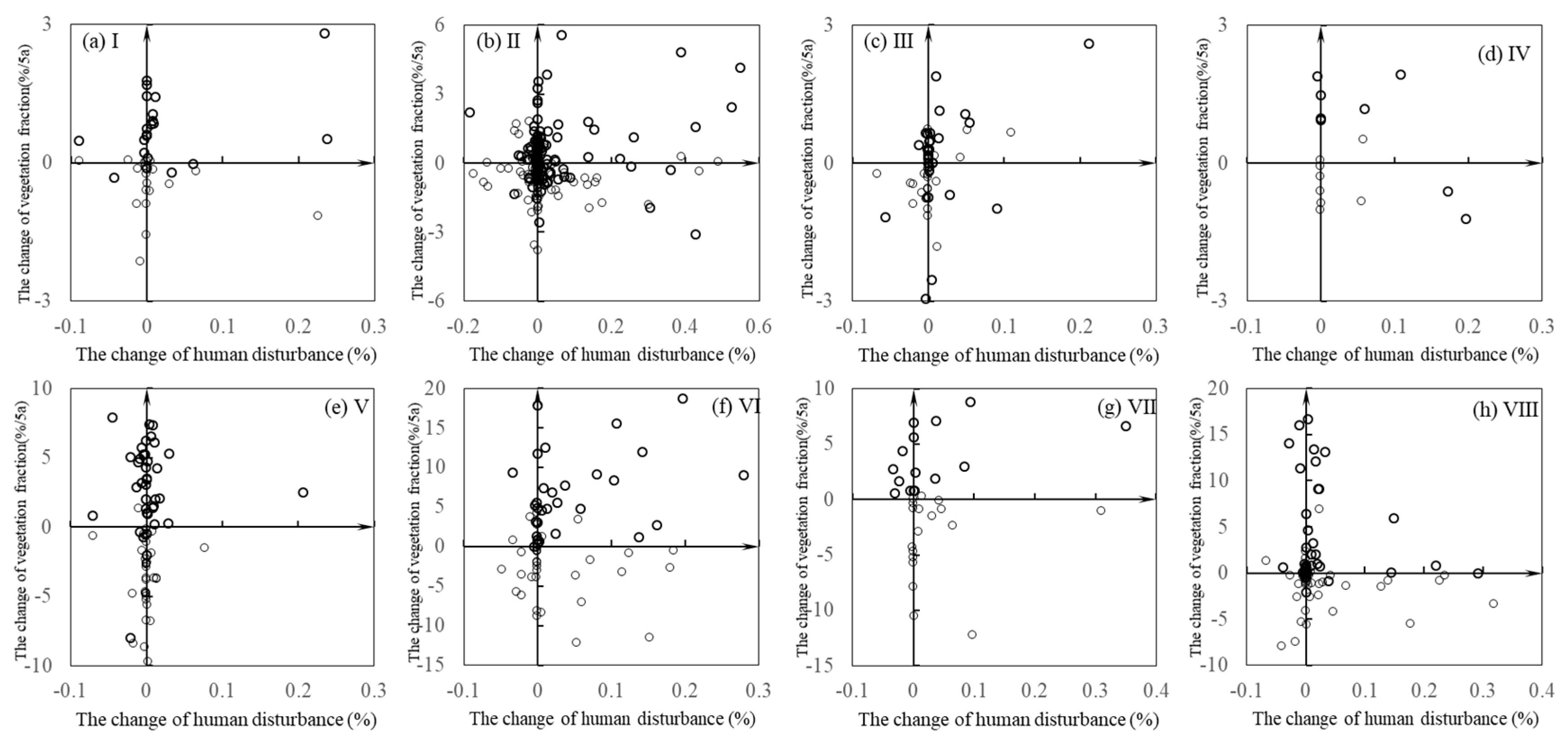
Finally, the relationship between changes in HD and VFC were analyzed and assessed to present the impacts of human activities on ecosystem qualities under climate change. In a NNR, if the HD is increasing, increasing VFC means the contribution is from climate change, and decreasing VFC means the impacts are from negative human activities under climate change; if the HD is decreasing, increasing VFC means the human activities are having a positive impact under climate change, and a decreasing VFC means the impacts are from changing climate.

3. Results

3.1. The Land Cover Changes in NNRs

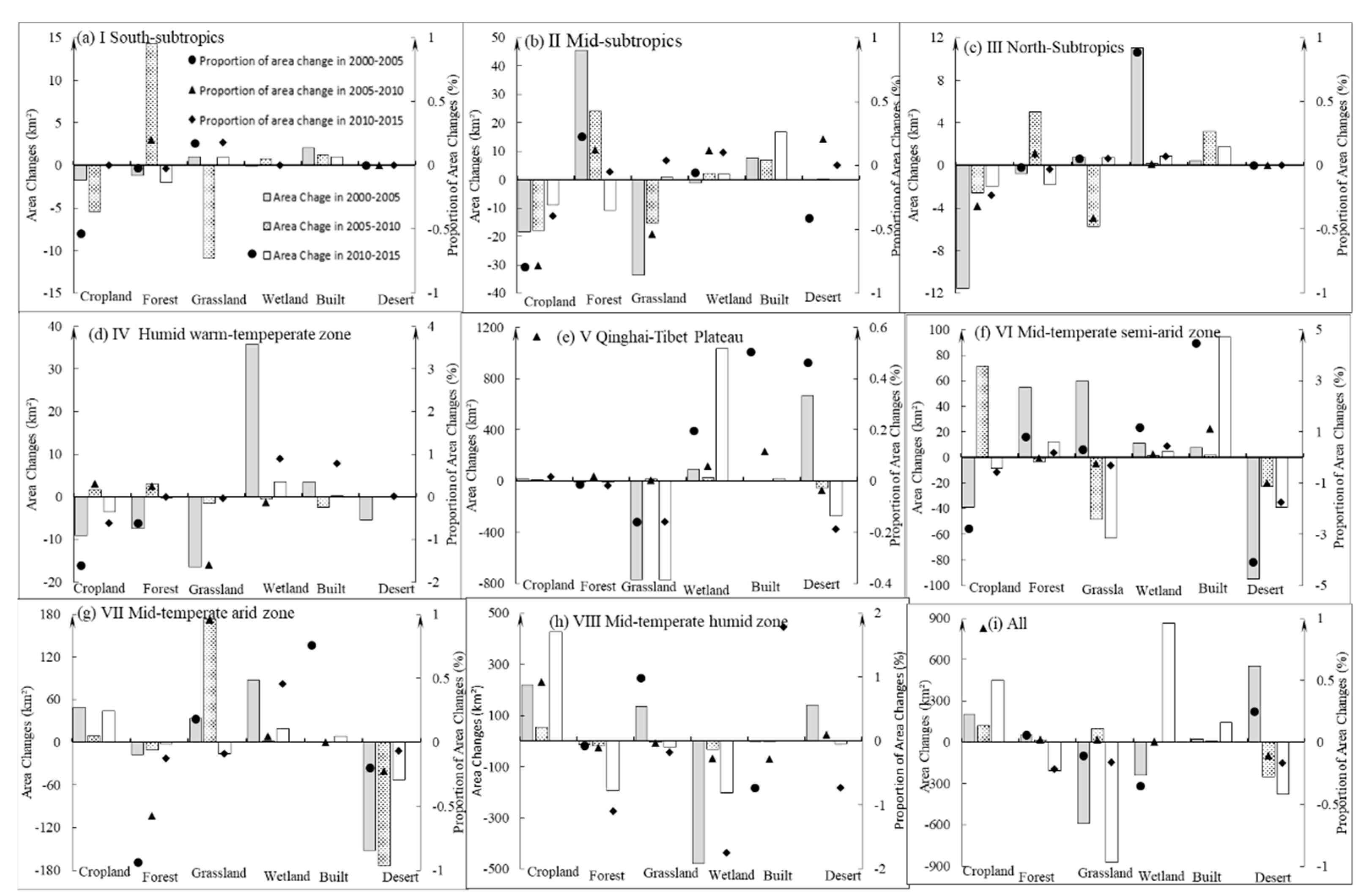
From 2000 to 2015, LCC in NNRs showed varied spatial and temporal patterns (Figure 2). For NNRs in subtropics, forest increased by 72.66 km2 in 15 years but decreased over the last 5 years, wetland increased by 15.63 km2, cropland decreased 68.47 km2, and built area increased by 40.95 km2. For NNRs in humid warm-temperate zone, forest decreased in the first 5 years but increased by 2.94 km2 later, wetland increased by 38.78 km2, grassland decreased continuously 17.99 km2, cropland decreased 10.96 km2, and the built area increased by 1.35 km2. For NNRs in mid-temperate humid zone, forest and wetland decreased by 227.36 km2 and 712.1 km2, respectively; cropland and built area increased by 699.38 km2 and 1.43 km2 respectively. For NNRs in mid-temperate semi-arid zone, forest and wetland increased by 63.32 km2 and 16.46 km2, respectively; grassland and desert decreased by 51.39 km2 and 156.57 km2, respectively; but built area increased by 104.24 km2. For NNRs in mid-temperate arid zone, grassland and wetland increased by 190.04 km2 and 108.82 km2, respectively; forest and desert decreased by 30.51 km2 and 379 km2, respectively, but cropland and built area increased by 102 km2 and 8.54 km2, respectively. For NNRs in Qinghai-Tibet Plateau, grassland and desert were transferred to wetland, and built area increased slightly.

3.2. Human Activities in NNRs

From 2000 to 2013, there are 128 NNRs with no nighttime light, 25 NNRs almost unchanging, 117 NNRs increasing, 29 NNRs decreasing (Table 2). In the humid warm-temperate zone, Qinghai-Tibet Plateau, mid-temperate semi-arid zone, and mid-temperate humid zone, more than half NNRs had increasing nighttime light. Two thirds of inland wetlands NNRs led increasing nighttime light. NNRs ordered from most to least for first 18 NNRs is Daqingshan of Inner Mongolia, Black Bee Nature Reserve in Northeast Raohe, East Dongting Lake, Western Ordos, Cangshan Erhai, Lingwu Baiqitan, Huihe, Yellow River Wetland, Helan Mountain, Xilinguole Grassland, Daheishan, Sanjiang, Shapotou, Xinxiang Yellow River Wetland, Jinyunshan, Lushan, Yangzi Alligator, and Sanjiangyuan nature reserves(Figure 3).
Overa recent 15-year period, HD was highest in the NNRs of mid-temperate humid zone and lowest in south-subtropics (Figure 4a). In mid-temperate humid zone, the HD of 4 NNRs (the Yellow River wetland in Henan, wetland birds in Xinxiang, Rongcheng swan, and Hengshui Lake) surpassed 10%, which led to a high level for the whole zone. In south-subtropics, the HD of more than half of NNRs was less than 1%. The HD of NNRs has intensified in the recent 5 years, especially the warm-temperate humid zone, which had the largest increases in HD as a result of city expansion and population increases, leading to an increasing area of built area. HD decreased in parts of the NNRs in mid-temperate arid and semi-arid zones. However, it was stable in subtropics and in Qinghai-Tibet Plateau, which means the establishment of NNRs limited human activities effectively (Figure 4b).

3.3. Dynamics of Ecosystem Qualities in NNRs

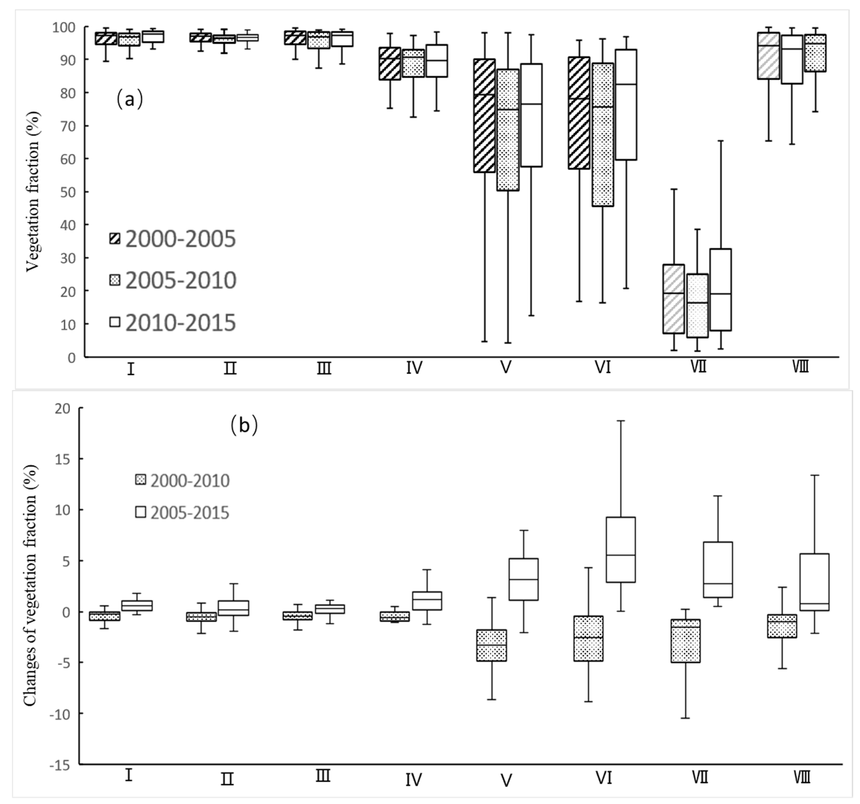
From 2000 to 2015, VFC had a high value in NNRs of subtropical zones. In subtropics, of all 154 NNRs, the VFC of 141 NNRs was greater than 90%. The NNRs in mid-temperate arid zone had the lowest VFC; of the 19 NNRs, the VFC of 11 NNRs was less than 20%. The VFC of the NNRs in Qinghai-Tibet Plateau and in mid-temperate semi-arid zone had a wide range from 5 to 95%, concentrated largely from 40 to 90% (Figure 5a). From 2000 to 2010, the VFC showed a tendency of declining in the NNRs of all climate zones. Of all 299 NNRs, 245 had a decreased trend. From 2005 to 2015, the VFC had an increasing trend in the NNRs of all climate zones, especially in Qinghai-Tibet Plateau and in mid-temperate semi-arid and arid zones. Of all 299 NNRs, 226 NNRs had an increased trend (Figure 5b).
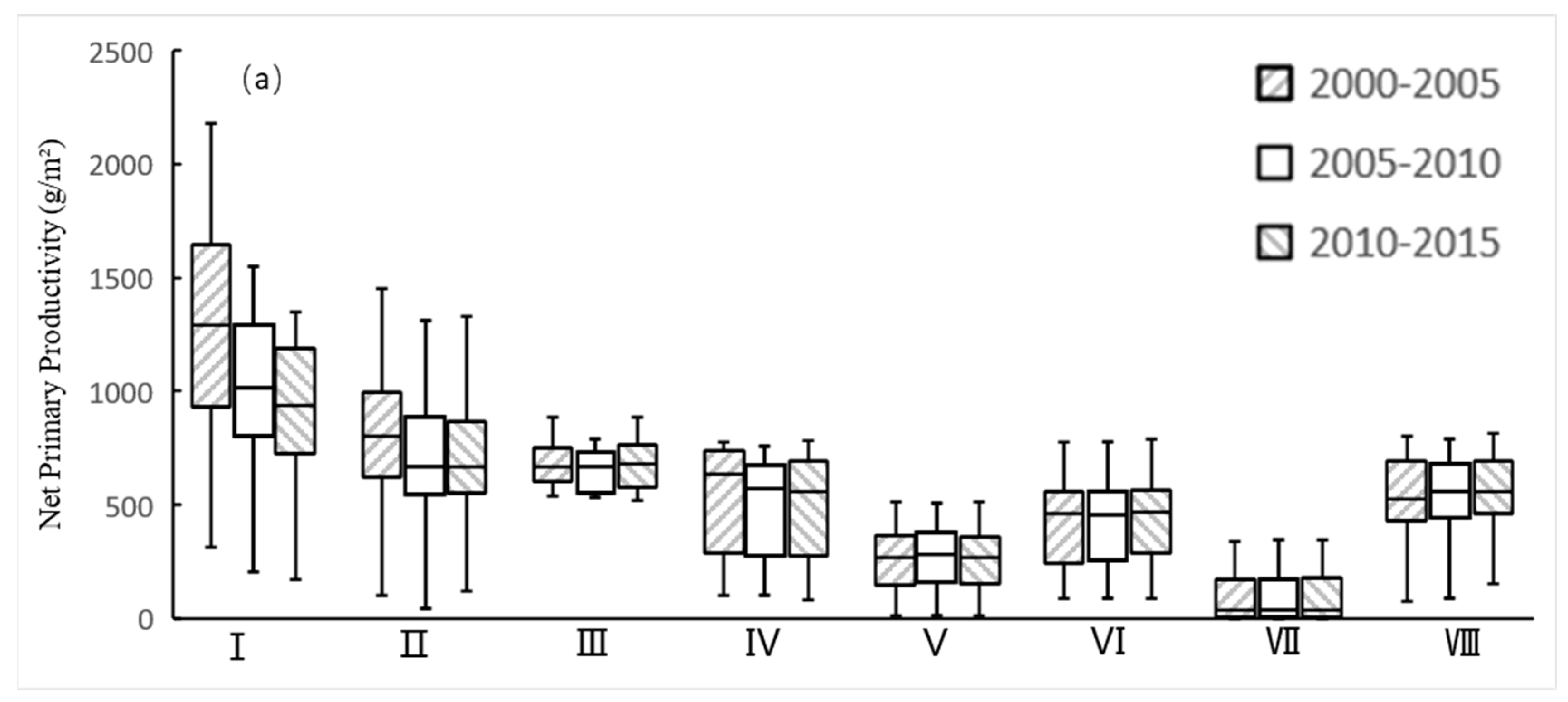
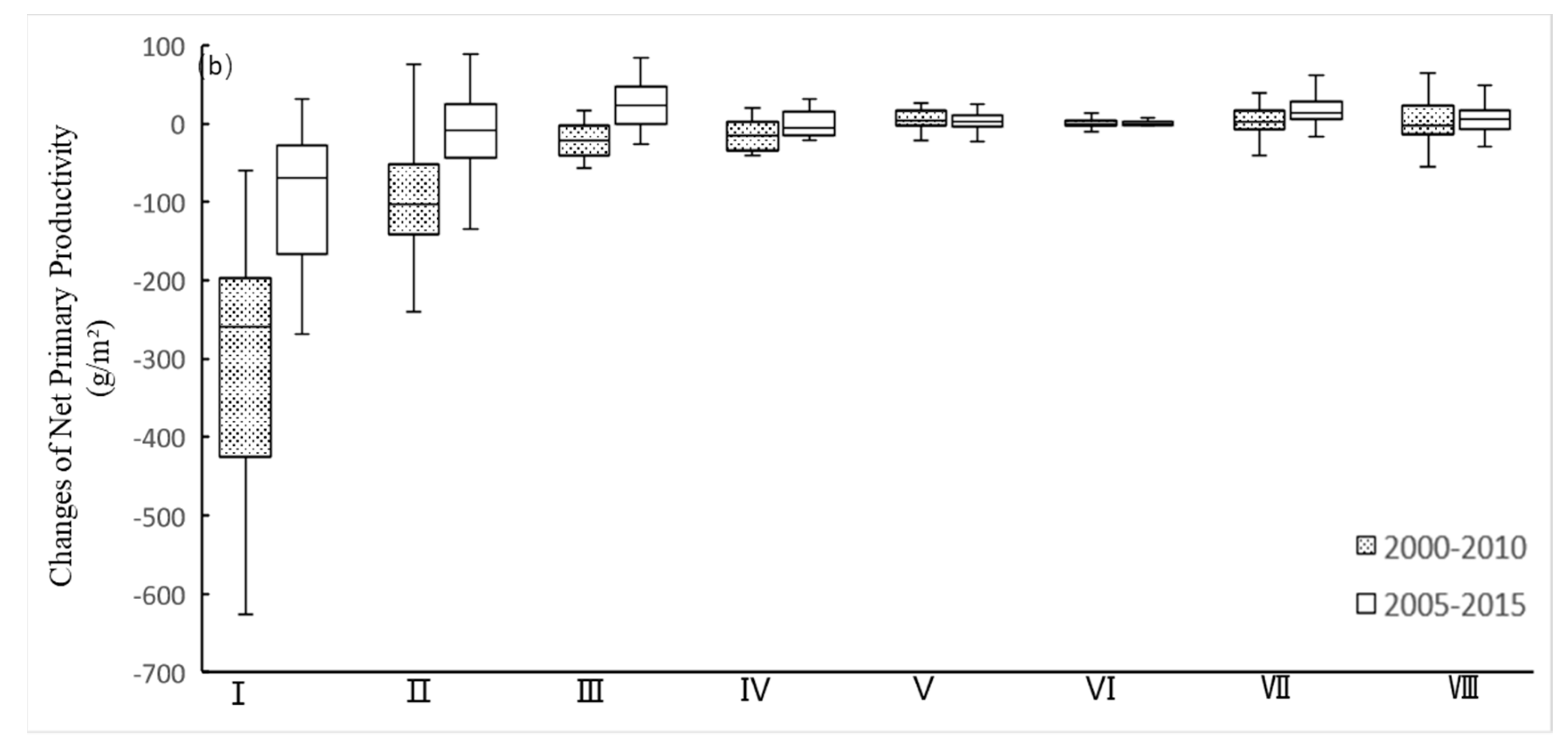
From 2000 to 2015, NPP was highest in NNRs of south-subtropics and lowest in mid-temperate arid NNRs (Figure 6a). In south-subtropics, of the 22 NNRs, the NPP of 20 was more than 800 g·m−2. In mid-temperate arid zone, of the 19 NNRs, the NPP of 12 was less than 100 g·m−2. In subtropical zones, NPP declined especially in south-subtropics. From 2000 to 2010, of the 154 NNRs, the NPP of 74 declined more than 100 g·m−2. From 2005 to 2015, only 12 NNRs declined more than 100 g·m−2. The NPP of the NNRs in other climate zones changed slightly (Figure 6b). The average VFC from 2010 to 2015 was higher than the average VFC from 2000 to 2005 in north-subtropics, mid-temperate semi-arid, arid and humid climate zones (Figure 6a).

3.4. The Relationships between Human Activities and Ecosystem Qualities

In most NNRs, especially those in south-subtropics and in Qinghai-Tibet Plateau, changes of VFC could be the result of climate change because VFC has increasing or decreasing while HD hardly changed (e.g., Figure 7a). In the case of increased HD, decreased VFC means there are negative impacts of human activities on the VFC in the NNRs (Figure 7b,f,h), though an increased VFC means there is a contribution of climate change in part of the NNRs (Figure 7c,d). If the HD value decreased, increased VFC means decreasing human activities or positive impacts of human activities on VFC in the NNRs, though a decreased VFC means the contribution is from climate change.

4. Discussion

4.1. Assessment of the Advantages and Disadvantages of NNRs in China

In China, the effectiveness of NNRs is expressed in maintaining biodiversity, especially in some endangered species, such as giant panda, which have been rescued effectively [41,42]. We find that VFC and NPP of the majority NNRs improved. There are researchers that suggest China’s nature reserves should pay more attention to key ecosystems and their services [41]. We also find that the establishment of NNRs has limited human activities successfully in NNRs, which is reflected in a decreased or stable HD, but has not been as successful in other NNRs, which is reflected in the increased built area. By analyzing the relationship between HD and VFC, we found most NNRs in south-subtropics and in Qinghai-Tibet Plateau are mainly impacted by climate change and some NNRs of other climate zones are obviously impacted by human activities. It is necessary to create different policies for various NNRs to control human activities. The management of NNRs has deficiencies. To begin with, NNRs are managed by Ministry of Ecology and Environment, the State Forestry Administration, and the Ministry of Agriculture, respectively. They are established for protecting biodiversity and ecosystem services. However, various management administrations may ignore original goals, and it is impossible to consider other stakeholders.
NNRs, of which the forest area decreased or development area increased, due to agricultural exploitation, increasing artificial construction, urban expansion or mineral exploitation [2,43]. The reasons for the influences could also be the regular productive and living needs of residents in the NNRs or illegal exploiting activities such as sand and rock mining and excavation. Moreover, the forest ecosystems protected in the NNRs accounted for only approximately 5% of China’s entire forested area. However, the proportion of protected grassland, wetland, and desert ecosystems was 18%, 20%, and 12%, respectively. Based on their high primary productivity and abundant biodiversity, forest ecosystems play a crucial role in underpinning global ecosystems and human social, economic development [23,44]. Policy makers should strengthen the protection of forest ecosystems.

4.2. Major Conservation Threats to Biodiversity and Ecosystems in NNRs

Both human activities and climate change take an important role in ecosystem services and biodiversity [1,2,45]. Many research forecasted the possible consequences of predicted climate change on biodiversity [13,14,15]. For example, changing climate is expected to induce altitudinal or latitudinal shifts in biology species’ ranges [46,47], reducing the effectiveness of conservation areas [48] or increasing the risk of species extinction [49,50]. The potential ecological consequences of these climate change trends are substantial. Climate change could impact ecosystems positively or negatively, the former in wetter regions and the latter in drier areas. In Qinghai-Tibet Plateau, changing climate impacts starting date of vegetation growing season directly that may extend the length time of vegetation growing season, which is related to gross and NPP closely [33]. A longer growing season will change the production directly, which would significantly affect local economy [33,51].
With changing climate, LCC, pollution and overexploitation results in ecosystem degradation and biodiversity decline [1,16]. For part terrestrial ecosystems, LCC has been the main directly driver of biodiversity and ecosystem services [52,53,54]. More than 85% of threatened species are impacted by habitat degradation or destruction [1]. In our study, the proportion of cropland and built area increased over in more than a half arid NNRs over the recent 15-year period, which illustrates the influence of agricultural exploitation, artificial construction, and mineral exploitation. In recent years, NNRs in developed regions of eastern China have been under the pressure of urban expansion and economic activities. It reminds one of the prediction that the expansion in cities and towns will threaten the area of existing NNRs [55]. In humid regions, VFC of NNRs has a strongly negative correlation with HD, which means intensified human activities would lead to lower VFC. However, in Qinghai-Tibet Plateau, no significant relationship was found among VFC, NPP and HD, and VFC were mainly impacted by climate change.

4.3. Adaptive Conservation Management and Regional Adaptation Strategies

Potential climate change, extreme disaster events, and increasing intensified human activities have pushed policy makers to explore more effective and sustainable conservation programs. They might desire to form participation mechanisms to involve persons in or surrounding the protected areas to protect their biodiversity and ecosystem services proactively. We strongly hold that policy analysis would consider the heterogeneity of various local ecosystems and biodiversity, and how measurements and investments should target valid goals. It is necessary to consolidate the management and monitoring of the PAs to one governmental department. Regular monitoring and evaluation of NNRs is necessary. The temporary improvement or degradation of ecology conditions can not be used to measure the failure or success of NNRs; instead, the long-term outcome should be the most important. The added challenge for conservation of NNRs is economic signals and returns quickly respond to any action relatively, but the change of ecosystem function may by decade lag. An effective monitoring system is necessary for the success of conservation projects.
In addition to endemic species or abundant biodiversity, high-quality ecosystems should be considered in conservation management. When reserves are researched, the quality of ecosystems and habitats should be considered. Locally suitable protection measurements should be carried out in habitat with the most threatened species to avoid the impacts of human activities that led to the fragmentation of the habitat. It is imperative to create regional adaptation strategies to guarantee the effectiveness of conservation programs. Conservation policy makers should take the negative and positive long-term impacts of programs into account, even when protection projects have changed local ecosystems [56]. Because NNRs are impacted by climate change and human activities, it also is necessary to distinguish the role of conservation projects with changing climate and to insure the function of NNRs with growing populations and expanding cities.
Nowadays, China has established other types of PAs consisting of forest parks, scenic spots, special marine reserves, aquatic germplasm resources conservation zones, geoparks, wetland parks, priority areas of biodiversity, ecosystem function conservation areas, and National Park Pilots, etc. In addition, to expand conservation areas and maintain sustainable development, the Chinese government struggles to delineate an ecological conservation red line. It should be quite measured in environmental quality, ecosystem services, and natural resources using to ensure regional and national ecology safety, peoples’ health, and sustainable economic and social development. Currently, China does well in conservation, but it is also on the path of exploring an effective protected system. In the future, the focus should be shifted from quantity to quality of PAs [22,41].

4.4. Research Deficiency and Prospect

Although we studied the relationships between human activities and ecosystem qualities, it is difficult to judge the contribution yet in consideration of the habitats of NNRs are influenced both by climate change and human activities. There are not statistical tests when we studied the relationships, which also limits describing the relationships. The current results show some dynamics but it remains uknown whether the conservation status has deteriorated or not. Further spatial analyses are needed to analyze the spatial pattern of changes (i.e., the hotspots of the deterioration) and their significance. In addition, we should further explore how to reduce the impacts of human activities and improve the effectiveness of NNRs under the background of rapid urbanization and increasing population.

5. Conclusions

This study analyzed the temporal and spatial variations of ecosystem change in habitat of NNRs through the indicators of LCC, VFC, NPP and nighttime light data, and the driving forces of human activities on the dynamics of the ecosystems for different type of NNRs in varied climatic zones were established. Furthermore, suggestions related to conservation policies were provided according to the results. Under climate change and positive human activities, the observed VFC and NPP improved and was restored in most of the NNRs. The relationship between HD and VFC showed that ecosystems in most NNRs in Qinghai-Tibet Plateau and in south-subtropics and mid-temperate arid zone are impacted by climate change. However, ecosystems in quantify NNRs showed intensified human activities, and thus a higher HD, due to increasing areas of cropland and built area, especially in humid warm-temperate zone and mid-temperate semi-arid zone. Negative human activities such as regular production and illegal exploitation should be limited or even forbidden in NNRs; however, adaptation and mitigation measures under climate change should be implemented according to the types of NNRs and local background. How to integrate various type of PAs in order to achieve the target of conservation is an important challenge for policy makers. Furthermore, the monitoring and assessment of the effects of PAs were significant for policy adjustments.

Author Contributions

Conceptualization, L.H. and J.Z.; Methodology, W.C.; Formal analysis, writing—original draft and investigation, P.Z.; Resources, T.X.

Funding

This research was funded by The National Key Research and Development Program, No. 2017YFC0506404 and the Key Programs for Frontier Science of the Chinese Academy of Sciences, No. QYZDB-SSW-DQC005.

Conflicts of Interest

The authors declare no conflict of interest.

References

  1. Pereira, H.M.; Navarro, L.M.; Martins, I.S. Global Biodiversity Change: The Bad, the Good, and the Unknown. Annu. Rev. Environ. Resour. 2012, 37, 25–50. [Google Scholar] [CrossRef]
  2. Titeux, N.; Henle, K.; Mihoub, J.B.; Regos, A.; Geijzendorffer, I.R.; Cramer, W.; Verburg, P.H.; Brotons, L. Biodiversity scenarios neglect future land-use changes. Glob. Chang. Biol. 2016, 22, 2505–2515. [Google Scholar] [CrossRef]
  3. Liu, J.; Ouyang, Z.; Pimm, S.L.; Raven, P.H.; Wang, X.; Miao, H.; Han, N. Protecting China’s biodiversity. Science 2003, 300, 1240–1241. [Google Scholar] [CrossRef]
  4. Howard, P.C.; Davenport, T.R.B.; Kigenyi, F.W.; Viskanic, P.; Baltzer, M.C.; Dickinson, C.J.; Lwanga, J.; Matthews, R.A.; Mupada, E. Protected Area Planning in the Tropics: Uganda’s National System of Forest Nature Reserves. Conserv. Biol. 2000, 14, 858–875. [Google Scholar] [CrossRef]
  5. Chape, S.; Harrison, J.; Spalding, M.; Lysenko, I. Measuring the extent and effectiveness of protected areas as an indicator for meeting global biodiversity targets. Philos. Trans. R. Soc. B Biol. Sci. 2005, 360, 443–455. [Google Scholar] [CrossRef] [PubMed]
  6. Jia, Q.; ZhiYun, O.; WeiHua, X.; Hong, M. Comparison and applications of methodologies for management effectiveness assessment of protected areas. Biodivers. Sci. 2010, 18, 90–99. [Google Scholar] [CrossRef]
  7. Maiorano, L.; Falcucci, A.; Boitani, L. Size-dependent resistance of protected areas to land-use change. Proc. R. Soc. B Biol. Sci. 2008, 275, 1297–1304. [Google Scholar] [CrossRef] [PubMed]
  8. Soutullo, A. Extent of the global network of terrestrial protected areas. Conserv. Biol. 2010, 24, 362–363. [Google Scholar]
  9. Radeloff, V.C.; Stewart, S.I.; Hawbaker, T.J.; Gimmi, U.; Pidgeon, A.M.; Flather, C.H.; Hammer, R.B.; Helmers, D.P. Housing growth in and near United States protected areas limits their conservation value. Proc. Natl. Acad. Sci. USA 2010, 107, 940–945. [Google Scholar] [CrossRef]
  10. Stein, B.A.; Scott, C.; Benton, N. Federal Lands and Endangered Species: The Role of Military and Other Federal Lands in Sustaining Biodiversity. BioScience. 2008, 58, 339–347. [Google Scholar] [CrossRef]
  11. Thomas, C.D.; Gillingham, P.K.; Bradbury, R.B.; Roy, D.B.; Anderson, B.J.; Baxter, J.M.; Bourn, N.A.D.; Crick, H.Q.P.; Findon, R.A.; Fox, R.; et al. Protected areas facilitate species’ range expansions. Proc. Natl. Acad. Sci. USA 2012, 109, 14063–14068. [Google Scholar] [CrossRef] [PubMed]
  12. Sebastian, O.; Sibyll, S.; Wolfgang, L.; Dieter, G. Three centuries of dual pressure from land use and climate change on the biosphere. Environ. Res. Lett. 2015, 10, 044011. [Google Scholar]
  13. Bellard, C.; Bertelsmeier, C.; Leadley, P.; Thuiller, W.; Courchamp, F. Impacts of climate change on the future of biodiversity. Ecol. Lett. 2012, 15, 365–377. [Google Scholar] [CrossRef] [PubMed]
  14. Staudinger, M.D.; Carter, S.L.; Cross, M.S.; Dubois, N.S.; Duffy, J.E.; Enquist, C.; Griffis, R.; Hellmann, J.J.; Lawler, J.J.; O’Leary, J.; et al. Biodiversity in a changing climate: A synthesis of current and projected trends in the US. Front. Ecol. Environ. 2013, 11, 465–473. [Google Scholar] [CrossRef]
  15. Pacifici, M.; Foden, W.B.; Visconti, P.; Watson, J.E.M.; Butchart, S.H.M.; Kovacs, K.M.; Scheffers, B.R.; Hole, D.G.; Martin, T.G.; Akcakaya, H.R.; et al. Assessing species vulnerability to climate change. Nat. Clim. Chang. 2015, 5, 215–224. [Google Scholar] [CrossRef]
  16. Leadley, P.W.; Krug, C.B.; Alkemade, R.; Pereira, H.M.; Sumaila, U.R.; Walpole, M.; Marques, A.; Newbold, T.; Teh, L.S.; van Kolck, J. Progress towards the Aichi Biodiversity Targets: An assessment of biodiversity trends, policy scenarios and key actions. Secr. Conv. Biol. Divers. 2014, 78, 3–23. [Google Scholar]
  17. McLellan, R.; Iyengar, L.; Jeffries, B.; Oerlemans, N. Living Planet Report 2014: Species and Spaces, People and Places; World Wide Fund for Nature: Gland, Switzerland, 2015. [Google Scholar]
  18. Foley, J.A.; DeFries, R.; Asner, G.P.; Barford, C.; Bonan, G.; Carpenter, S.R.; Chapin, F.S.; Coe, M.T.; Daily, G.C.; Gibbs, H.K.; et al. Global Consequences of Land Use. Science 2005, 309, 570–574. [Google Scholar] [CrossRef]
  19. McDonald, R.I.; Kareiva, P.; Forman, R.T. The implications of current and future urbanization for global protected areas and biodiversity conservation. Biol. Conserv. 2008, 141, 1695–1703. [Google Scholar] [CrossRef]
  20. Naughton-Treves, L.; Holland, M.B.; Brandon, K. The role of protected areas in conserving biodiversity and sustaining local livelihoods. Annu. Rev. Environ. Resour. 2005, 30, 219–252. [Google Scholar] [CrossRef]
  21. Juffe-Bignoli, D.; Burgess, N.; Bingham, H.; Belle, E.; De Lima, M.; Deguignet, M.; Bertzky, B.; Milam, A.; Martinez-Lopez, J.; Lewis, E. Protected Planet Report 2014; UNEP-WCMC: Cambridge, UK, 2015. [Google Scholar]
  22. Zheng, J.; Yin, Y.; Li, B. A New Scheme for Climate Regionalization in China. Acta Geogr. Sin. 2010, 65, 3–12. [Google Scholar]
  23. Liu, J.; Kuang, W.; Zhang, Z.; Xu, X.; Qin, Y.; Ning, J.; Zhou, W.; Zhang, S.; Li, R.; Yan, C.; et al. Spatiotemporal characteristics, patterns, and causes of land-use changes in China since the late 1980s. J. Geogr. Sci. 2014, 24, 195–210. [Google Scholar] [CrossRef]
  24. Zhuo, L.; Shi, P.; Chen, J. Application of compound night light index derived from DMSP/OLS data to urbanization analysis in China in the 1990s. Acta Geogr. Sin. 2003, 58, 893–902. [Google Scholar]
  25. Zhao, G.; Liu, J.; Kuang, W.; Ouyang, Z.; Xie, Z. Disturbance impacts of land use change on biodiversity conservation priority areas across China: 1990–2010. J. Geogr. Sci. 2015, 25, 515–529. [Google Scholar] [CrossRef]
  26. Xu, Y.; Xu, X.; Tang, Q. Human activity intensity of land surface: Concept, methods and application in China. J. Geogr. Sci. 2016, 26, 1349–1361. [Google Scholar] [CrossRef]
  27. Zhu, P.; Huang, L.; Xiao, T.; Wang, J. Dynamic changes of habitats in china’s typical national nature reserves on spatial and temporal scales. J. Geogr. Sci. 2018, 28, 778–790. [Google Scholar] [CrossRef]
  28. Leprieur, C.; Verstraete, M.M.; Pinty, B. Evaluation of the performance of various vegetation indices to retrieve vegetation cover from AVHRR data. Remote Sens. Rev. 1994, 10, 265–284. [Google Scholar] [CrossRef]
  29. Melillo, J.M.; McGuire, A.D.; Kicklighter, D.W.; Moore, B.; Vorosmarty, C.J.; Schloss, A.L. Global climate change and terrestrial net primary production. Nature 1993, 363, 234–240. [Google Scholar] [CrossRef]
  30. Potter, C.S.; Randerson, J.T.; Field, C.B.; Matson, P.A.; Vitousek, P.M.; Mooney, H.A.; Klooster, S.A. Terrestrial ecosystem production: A process model based on global satellite and surface data. Glob. Biogeochem. Cycles. 1993, 7, 811–841. [Google Scholar] [CrossRef]
  31. Crabtree, R.; Potter, C.; Mullen, R.; Sheldon, J.; Huang, S.; Harmsen, J.; Rodman, A.; Jean, C. A modeling and spatio-temporal analysis framework for monitoring environmental change using NPP as an ecosystem indicator. Remote Sens. Environ. 2009, 113, 1486–1496. [Google Scholar] [CrossRef]
  32. Running, S.W.; Nemani, R.R.; Heinsch, F.A.; Zhao, M.; Reeves, M.; Hashimoto, H. A continuous satellite-derived measure of global terrestrial primary production. BioScience 2004, 54, 547–560. [Google Scholar] [CrossRef]
  33. Zhang, G.; Zhang, Y.; Dong, J.; Xiao, X. Green-up dates in the Tibetan Plateau have continuously advanced from 1982 to 2011. Proc. Natl. Acad. Sci. USA 2013, 110, 4309–4314. [Google Scholar] [CrossRef] [PubMed]
  34. Zhang, Y.; Hu, Z.; Qi, W.; Wu, X.; Bai, W.; Li, L.; Ding, M.; Liu, L.; Wang, Z.; Zheng, D. Assessment of protection effectiveness of nature reserves on the Tibetan Plateau based on net primary production and the large-sample-comparison method. Acta Geogr. Sin. 2015, 70, 1027–1040. [Google Scholar]
  35. Prince, S.D.; Goward, S.N. Global primary production: A remote sensing approach. J. Biogeogr. 1995, 22, 815–835. [Google Scholar] [CrossRef]
  36. Cao, M.; Prince, S.D.; Li, K.; Tao, B.; Small, J.; Shao, X. Response of terrestrial carbon uptake to climate interannual variability in China. Glob. Chang. Biol. 2003, 9, 536–546. [Google Scholar] [CrossRef]
  37. Allen, R.G.; Pereira, L.S.; Raes, D.; Smith, M. Crop Evapotranspiration-Guidelines for Computing Crop Water Requirements-FAO Irrigation and Drainage Paper 56; FAO, Food and Agriculture Organization of the United Nations: Rome, Italy, 1998. [Google Scholar]
  38. Liu, R.; Chen, J.; Liu, J.; Deng, F.; Sun, R. Application of a new leaf area index algorithm to China’s landmass using MODIS data for carbon cycle research. J. Environ. Manag. 2007, 85, 649–658. [Google Scholar] [CrossRef]
  39. Stewart, J. Modelling surface conductance of pine forest. Agric. For. Meteorol. 1988, 43, 19–35. [Google Scholar] [CrossRef]
  40. Cao, M.; Prince, S.D.; Small, J.; Goetz, S.J. Remotely sensed interannual variations and trends in terrestrial net primary productivity 1981–2000. Ecosystems 2004, 7, 233–242. [Google Scholar] [CrossRef]
  41. Xu, W.; Xiao, Y.; Zhang, J.; Yang, W.; Zhang, L.; Hull, V.; Wang, Z.; Zheng, H.; Liu, J.; Polasky, S.; et al. Strengthening protected areas for biodiversity and ecosystem services in China. Proc. Natl. Acad. Sci. USA 2017, 114, 1601–1606. [Google Scholar] [CrossRef] [Green Version]
  42. Zhang, L.; Luo, Z.; Mallon, D.; Li, C.; Jiang, Z. Biodiversity conservation status in China’s growing protected areas. Biol. Conserv. 2017, 210, 89–100. [Google Scholar] [CrossRef]
  43. Xiao, J.; Zhou, Y.; Zhang, L. Contributions of natural and human factors to increases in vegetation productivity in China. Ecosphere 2015, 6, 1–20. [Google Scholar] [CrossRef]
  44. Zhao, M.; Yue, T.; Zhao, N.; Sun, X. Spatial distribution of forest vegetation carbon stock in China based on human activities SM. Acta Geogr. Sin. 2013, 68, 1212–1224. [Google Scholar]
  45. Struebig, M.J.; Fischer, M.; Gaveau, D.L.A.; Meijaard, E.; Wich, S.A.; Gonner, C.; Sykes, R.; Wilting, A.; Kramer-Schadt, S. Anticipated climate and land-cover changes reveal refuge areas for Borneo’s orang-utans. Glob. Chang. Biol. 2015, 21, 2891–2904. [Google Scholar] [CrossRef]
  46. Maes, D.; Titeux, N.; Hortal, J.; Anselin, A.; Decleer, K.; De Knijf, G.; Fichefet, V.; Luoto, M. Predicted insect diversity declines under climate change in an already impoverished region. J. Insect Conserv. 2010, 14, 485–498. [Google Scholar] [CrossRef]
  47. Barbet-Massin, M.; Jetz, W. The effect of range changes on the functional turnover, structure and diversity of bird assemblages under future climate scenarios. Glob. Chang. Biol. 2015, 21, 2917–2928. [Google Scholar] [CrossRef]
  48. Araújo, M.B.; Alagador, D.; Cabeza, M.; Nogués-Bravo, D.; Thuiller, W. Climate change threatens European conservation areas. Ecol. Lett. 2011, 14, 484–492. [Google Scholar] [CrossRef] [Green Version]
  49. Thomas, C.D.; Cameron, A.; Green, R.E.; Bakkenes, M.; Beaumont, L.J.; Collingham, Y.C.; Erasmus, B.F.N.; De Siqueira, M.F.; Grainger, A.; Hannah, L.; et al. Extinction risk from climate change. Nature 2004, 427, 145–148. [Google Scholar] [CrossRef]
  50. Urban, M.C. Accelerating extinction risk from climate change. Science 2015, 348, 571–573. [Google Scholar] [CrossRef] [Green Version]
  51. Shen, M.; Piao, S.; Cong, N.; Zhang, G.; Jassens, I.A. Precipitation impacts on vegetation spring phenology on the Tibetan Plateau. Glob. Chang. Biol. 2015, 21, 3647–3656. [Google Scholar] [CrossRef] [Green Version]
  52. Pereira, H.M.; Leadley, P.W.; Proença, V.; Alkemade, R.; Scharlemann, J.P.W.; Fernandez-Manjarrés, J.F.; Araújo, M.B.; Balvanera, P.; Biggs, R.; Cheung, W.W.L.; et al. Scenarios for Global Biodiversity in the 21st Century. Science 2010, 330, 1496–1501. [Google Scholar] [CrossRef] [Green Version]
  53. Jetz, W.; Wilcove, D.S.; Dobson, A.P. Projected impacts of climate and land-use change on the global diversity of birds. PLoS Biol. 2007, 5, e157. [Google Scholar] [CrossRef] [Green Version]
  54. Visconti, P.; Bakkenes, M.; Baisero, D.; Brooks, T.; Butchart, S.H.M.; Joppa, L.; Alkemade, R.; Di Marco, M.; Santini, L.; Hoffmann, M.; et al. Projecting Global Biodiversity Indicators under Future Development Scenarios. Conserv. Lett. 2016, 9, 5–13. [Google Scholar] [CrossRef]
  55. Yan, Y.; Wang, Z.; Gao, J.; Xu, W.; Jiang, M. Regional distribution characteristics of nature reserves and the influencing factors in China. Acta Ecol. Sin. 2010, 30, 5091–5097. [Google Scholar]
  56. Liu, J.; Xu, X.; Shao, Q. Grassland degradation in the “Three-River Headwaters” region, Qinghai Province. J. Geogr. Sci. 2008, 18, 259–273. [Google Scholar] [CrossRef]
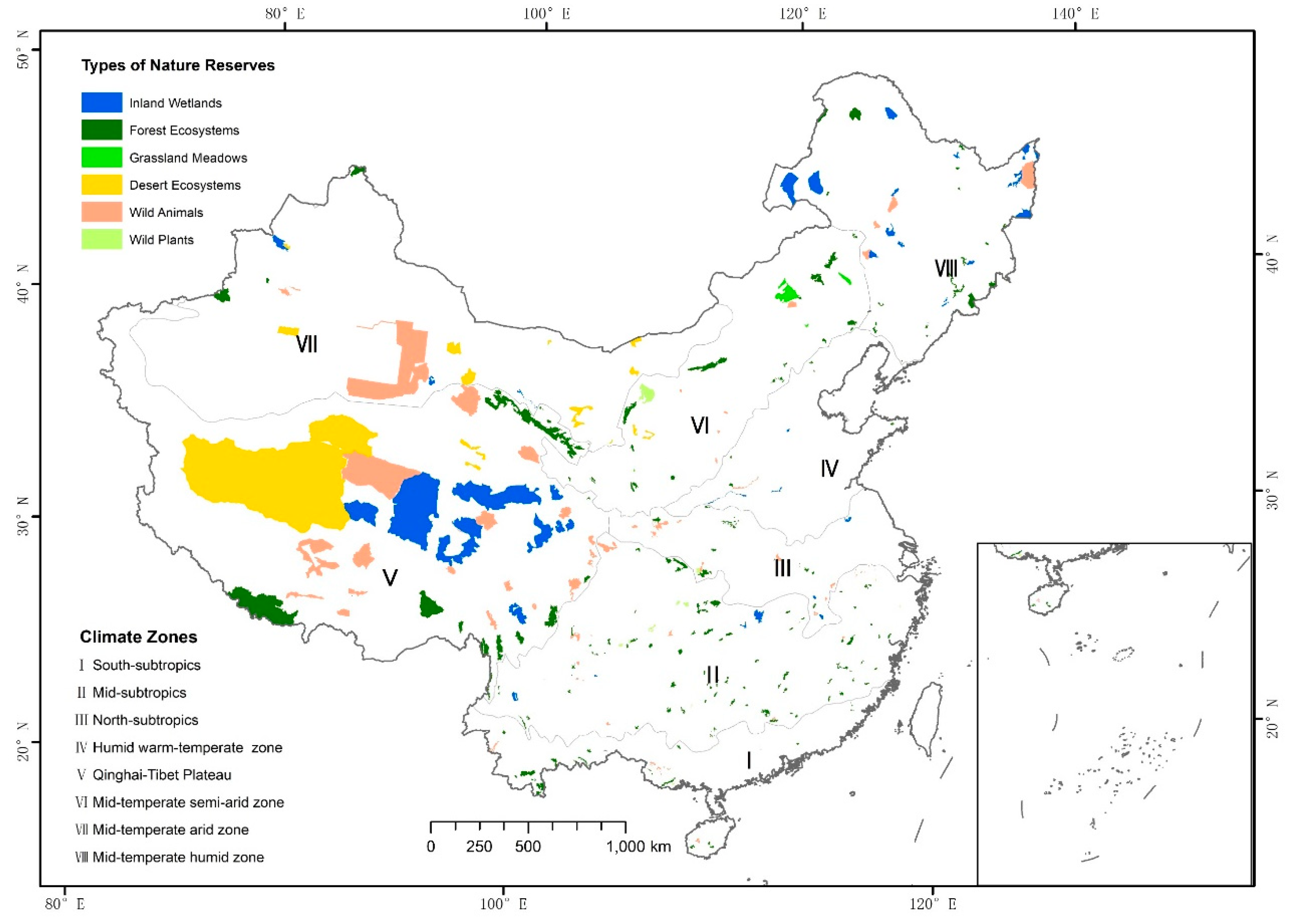
Figure 1. The spatial distribution of national nature reserves in China.
Sustainability 11 06629 g001
Figure 2. Land use and land cover change in national nature reserves in eight climate zones.
Sustainability 11 06629 g002
Figure 3. Spatial distribution of nighttime light data change in national nature reserves.
Sustainability 11 06629 g003
Figure 4. Human disturbances (a) and their changes(b) in eight climate zones (Ⅰ South-subtropics, Ⅱ Mid-subtropics, Ⅲ North-subtropics, Ⅳ Humid warm-temperate zone, Ⅴ Qinghai-Tibet Plateau, Ⅵ Mid-temperate semi-arid zone, Ⅶ Mid-temperate arid zone, Ⅷ Mid-temperate humid zone).
Sustainability 11 06629 g004
Figure 5. Vegetation fraction (a) and their changes(b) in eight climate zones (Ⅰ South-subtropics, Ⅱ Mid-subtropics, Ⅲ North-subtropics, Ⅳ Humid warm-temperate zone, Ⅴ Qinghai-Tibet Plateau, Ⅵ Mid-temperate semi-arid zone, Ⅶ Mid-temperate arid zone, Ⅷ Mid-temperate humid zone).
Sustainability 11 06629 g005
Figure 6. Net Primary Productivity (a) and their changes (b) in eight climate zones (Ⅰ South-subtropics, Ⅱ Mid-subtropics, Ⅲ North-subtropics, Ⅳ Humid warm-temperate zone, Ⅴ Qinghai-Tibet Plateau, Ⅵ Mid-temperate semi-arid zone, Ⅶ Mid-temperate arid zone, Ⅷ Mid-temperate humid zone).
Sustainability 11 06629 g006aSustainability 11 06629 g006b
Figure 7. The relationships between human disturbance and vegetation fraction (Ⅰ South-subtropics, Ⅱ Mid-subtropics, Ⅲ North-subtropics, Ⅳ Humid warm-temperate zone, Ⅴ Qinghai-Tibet Plateau, Ⅵ Mid-temperate semi-arid zone, Ⅶ Mid-temperate arid zone, Ⅷ Mid-temperate humid zone).
Sustainability 11 06629 g007
Table 1. Conversion factor of different land use and land cover types.
Land Use and Land CoverCroplandArtificial ForestReservoirBuilt-Up AreasOthers
Conversion factor0.20.1330.610
Table 2. Frequencies of nighttime light change events in national nature reserves from 2000 to 2013 (Ⅰ South-subtropics, Ⅱ Mi- subtropics, Ⅲ North-subtropics, Ⅳ Humid warm-temperate zone, Ⅴ Qinghai-Tibet Plateau, Ⅵ Mid-temperate semi-arid zone, Ⅶ Mid-temperate arid zone, Ⅷ Mid-temperate humid zone).
Climate ZonesNo LightUnchangedIncreasedDecreasedTypes of National Nature ReservesNo LightUnchangedIncreasedDecreased
6394Grassland meadow3010
659199Desert ecosystems5071
141132Inland wetlands56241
1271Forest ecosystems80155418
131195Wild animals292288
113183Wild plants6231
10081
86244
Total1282511729 1282511729