Characterization of Territorial Spatial Agglomeration Based on POI Data: A Case Study of Ningbo City, China

Abstract
1. Introduction
2. Data and Methods
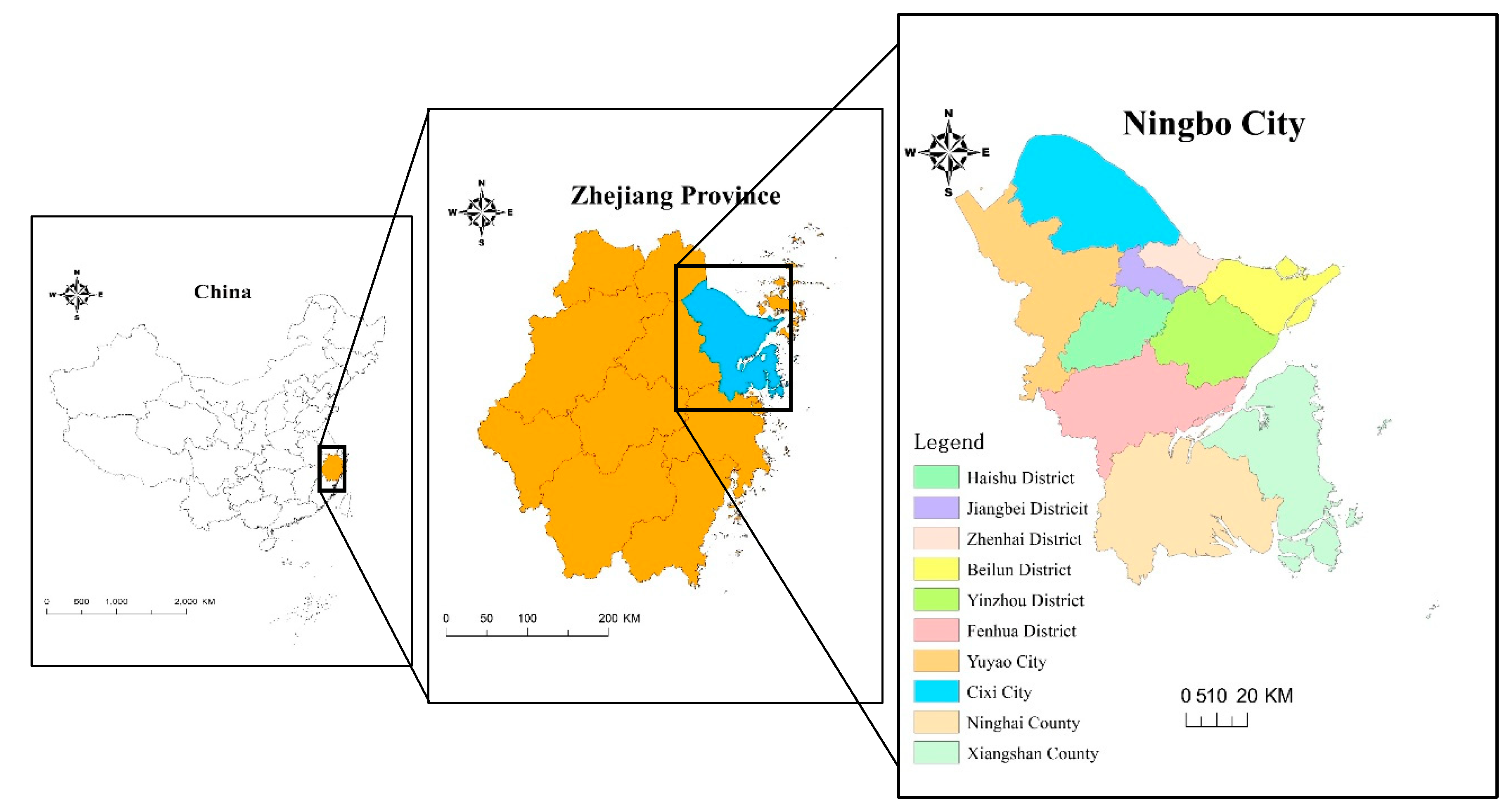
2.1. Study Area
2.2. Data Sources
2.3. Research Method
2.3.1. Standard Deviational Ellipse
2.3.2. Nearest Neighbor Index
2.3.3. Ripley’s K Function
2.3.4. Kernel Density Estimation
3. Results Analysis
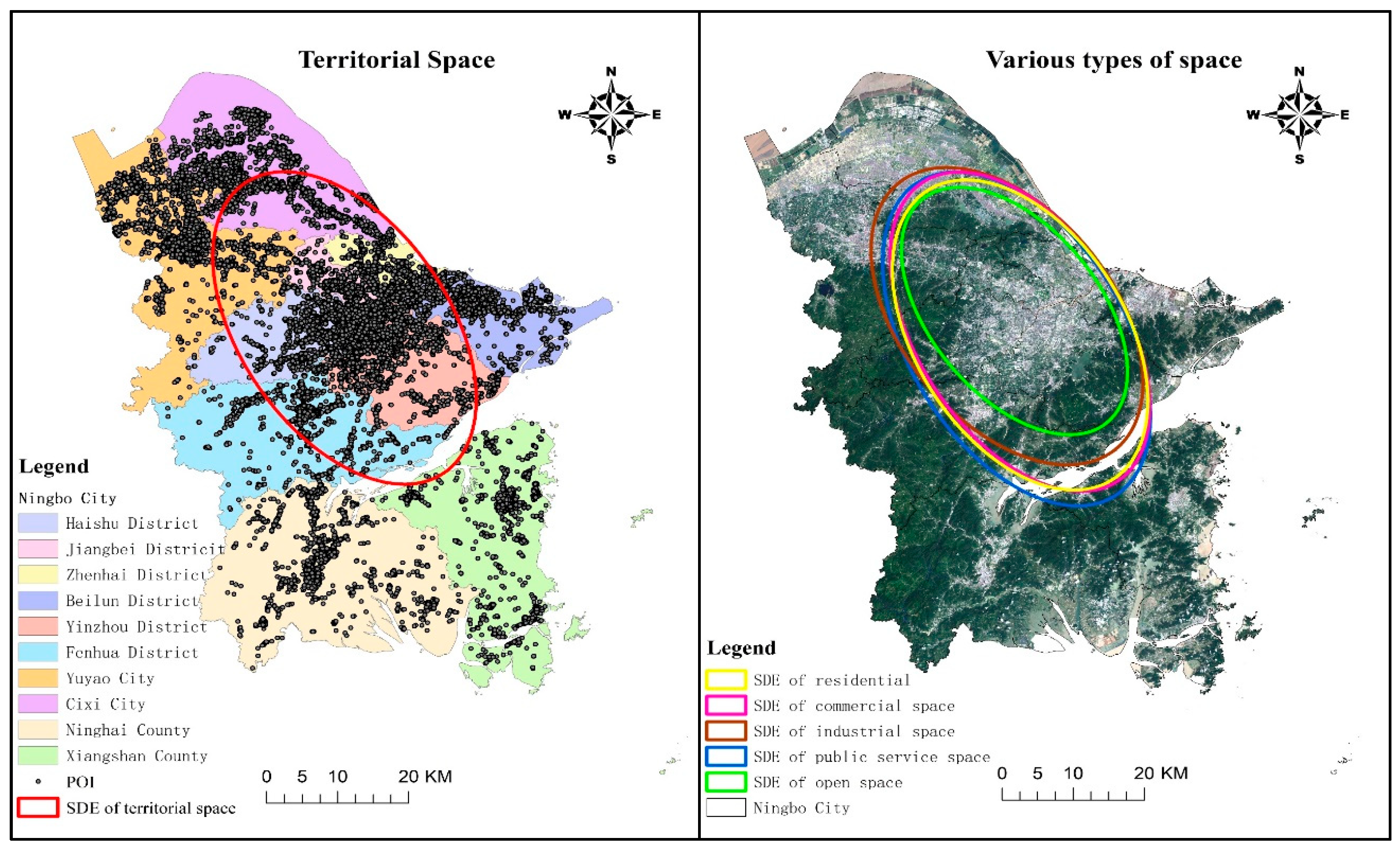
3.1. Distribution Pattern of Territorial Space Based on the SDE Method
3.2. Characteristics of Territorial Spatial Agglomeration Based on NNI
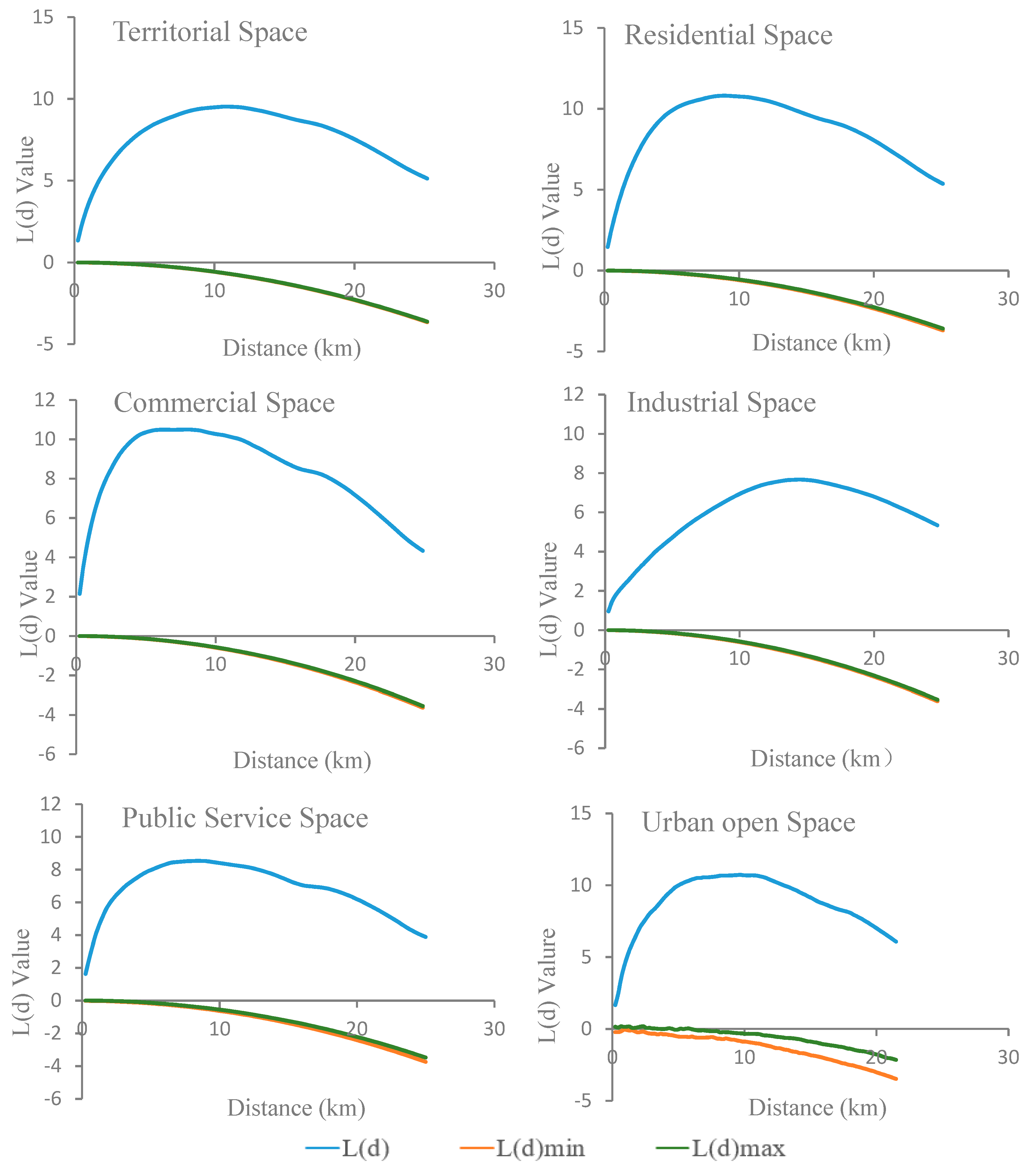
3.3. Spatial Scale Effect of Territorial Spatial Agglomeration Based on Ripley’s K Function
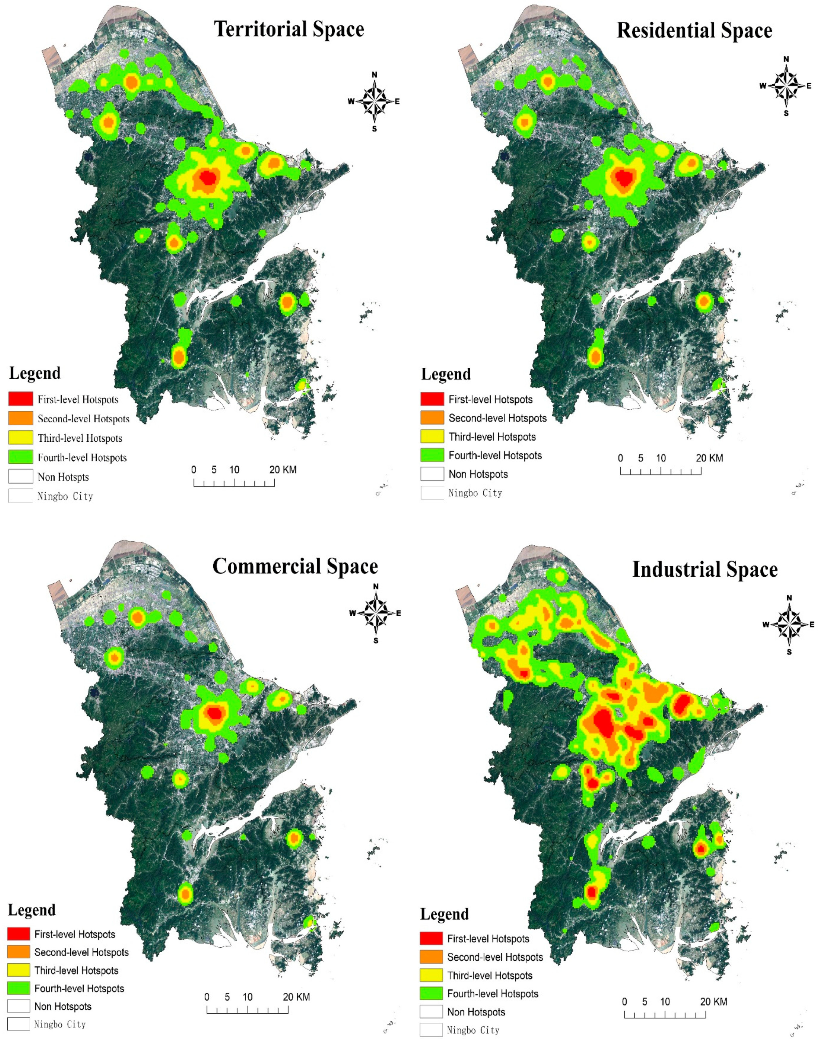
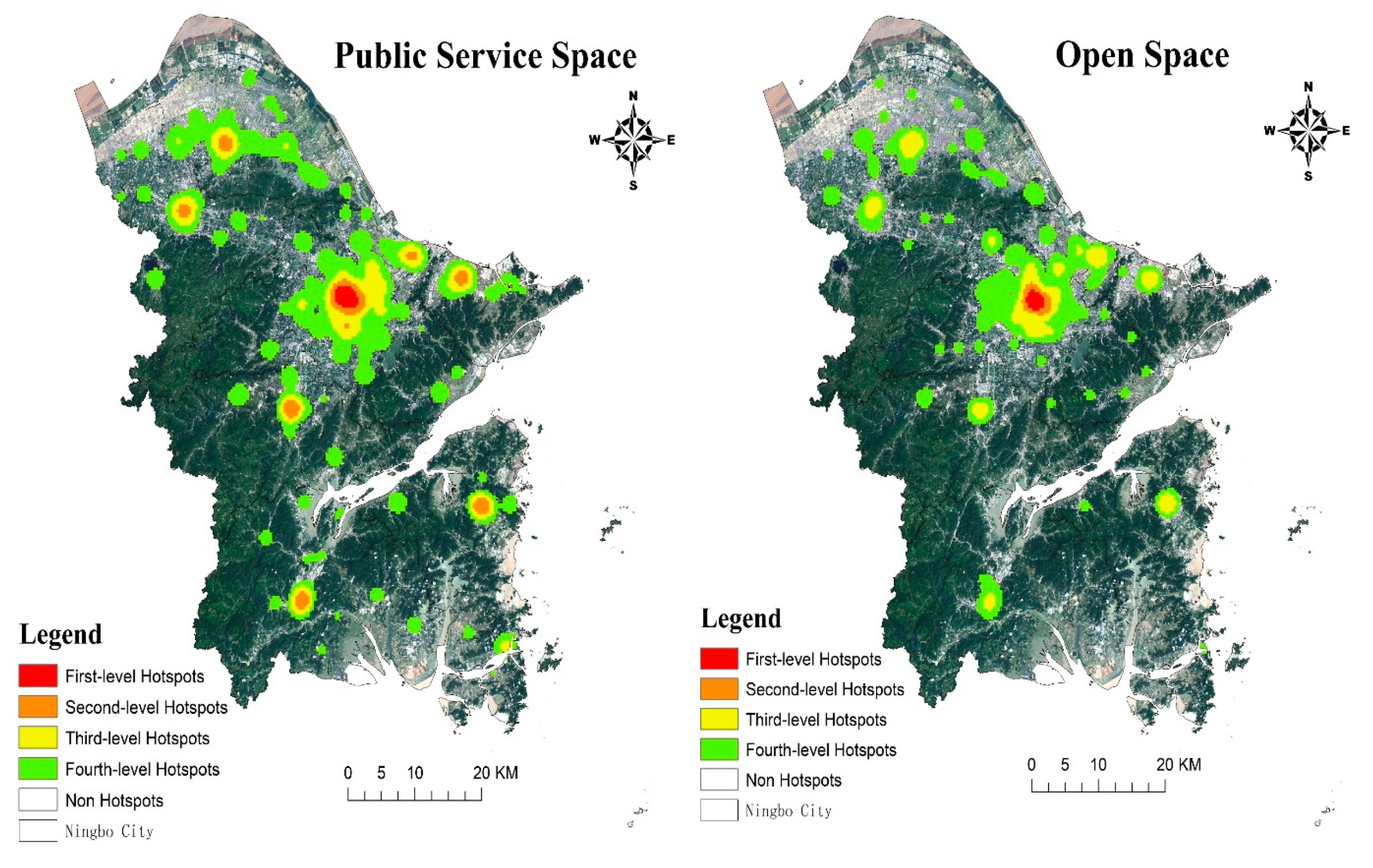
3.4. Hotspots Identification of Territorial Spatial Agglomeration Based on KDE
4. Discussion
4.1. Comparisons with Traditional Research
4.2. Agglomeration Promotes Regional Coordinated Development
4.3. Differentiation of Agglomeration Effect under Spatial Competition
4.4. Limitations and Future Research
5. Conclusions
- The overall distribution pattern of the territorial space is characterized by “dense middle and sparse edge”. The distribution trend is along the “northwest to southeast” direction, with significant directionality, and the spatial distribution of each type is quite different. The SDE of residential and commercial space is more consistent with the overall appearance of territorial space. The distribution center of SDE of industrial space is obviously northward, and the spreading range of SDE in public service space is the largest, while the urban open space is on the contrary.
- The results of NNI show that the entire territorial space presents spatial agglomeration, and the agglomeration characteristics of the commercial space are more significant. Moreover, the spatial distribution of residential, industrial and public service space is relatively agglomerative, while the agglomeration degree of the Urban open space is relatively weak.
- Ripley’s K function analysis verifies that there was scale effect in territorial spatial agglomeration, with the decline of the geographical distance, and the trend of territorial spatial agglomeration presents an inverted “U” structure. However, the spatial scale and corresponding L(d) peak value of different types of spatial agglomeration are significantly different. Commercial space is expected to have a higher rent, so the spatial scale of commercial spatial agglomeration is the smallest; while industrial space is agglomerated in a larger space, and the range of location selection is also the largest.
- The distribution of agglomeration hotspots in Ningbo is spread from the core of Sanjiangkou to the periphery. The spatial distribution of hotspots at different levels shows obvious distance attenuation rule. The overall distribution characteristics are “river-oriented” and “sea-oriented”, and the locking effect of a single center is still significantly higher than the evacuation “magnetic force” of multiple centers in Ningbo city. It is worth noting that the agglomeration hotspots of industrial space are mainly distributed in a concentrated contiguous pattern around Sanjiangkou, two axial agglomeration hotspots are formed between Yuyao, Cixi and the central city. In the future, we should effectively disperse the densely clustered areas in the central urban area, and focus on cultivating peripheral sub-centers/groups to enhance the positive interaction between multiple centers.
Author Contributions
Funding
Conflicts of Interest
References
- National Main Functional Area Planning—Building an Efficient, Coordinated and Sustainable Land and Space Development Pattern. Available online: http://www.gov.cn/zhengce/content/2011-06/08/content_1441.htm (accessed on 8 June 2011).
- Yu, F.; Zhang, L.J.; Ma, Y.H.; Fu, R. Strategic Options for Chinese National Land Space Development: Agglomeration Development and Regional Development. Land Res. 2014, 50–56. [Google Scholar]
- National Territory Planning Outline (2016–2030). Available online: http://www.gov.cn/zhengce/content/2017-02/04/content_5165309.htm (accessed on 4 February 2017).
- Krugman, P. Increasing Returns and Economic Geography. J. Polit. Econ. 1991, 99, 483–499. [Google Scholar] [CrossRef]
- Fan, C.C.; Scott, A.J. Industrial Agglomeration and Development: A Survey of Spatial Economic Issues in East Asia and a Statistical Analysis of Chinese Regions. Econ. Geog. 2003, 79, 295–319. [Google Scholar] [CrossRef]
- Cainelli, G.; Iacobucci, D.; Morganti, E. Spatial agglomeration and business groups: New evidence from Italian industrial districts. Reg. Stud. 2006, 40, 507–518. [Google Scholar] [CrossRef]
- Vogiatzoglou, K.; Tskeris, T. Spatial Agglomeration of Manufacturing in Greece: Sectoral Patterns and Determinants. Eur. Plan. Stud. 2013, 21, 1853–1872. [Google Scholar] [CrossRef]
- Majewska, J. Inter-regional agglomeration effects in tourism in Poland. Tourism. Geog. 2015, 17, 408–436. [Google Scholar] [CrossRef]
- Shen, N.; Zhao, Y.Q.; Wang, Q.W. Diversified Agglomeration, Specialized Agglomeration, and Emission Reduction Effect—A Nonlinear Test Based on Chinese City Data. Sustainability 2018, 10, 2002. [Google Scholar] [CrossRef]
- European Commission. First Report on Economic and Social Cohesion; Office for Official Publications of European Communities: Luxembourg, 1996.
- Chasco, C.; Lopez, A.; Guillain, R. The Influence of Geography on the Spatial Agglomeration of Production in the European Union. Spat. Econ. Anal. 2012, 7, 247–263. [Google Scholar] [CrossRef]
- Gerritse, M.; Arribas-Bel, D. Concrete agglomeration benefits: Do roads improve urban connections or just attract more people? Reg. Stud. 2017, 52, 1134–1149. [Google Scholar] [CrossRef]
- Ruhiiga, T.M. Growth of Urban Agglomeration Nodes in Eastern Africa. J. Hum. Ecol. 2013, 41, 237–246. [Google Scholar] [CrossRef]
- Ouyang, H. Further Optimizing the Policy Direction of Territorial Spatial Development Pattern. Sci. Macro Man 2012, 35–37, 43. [Google Scholar] [CrossRef]
- Fan, J.; Zhou, K.; Chen, D. Innovation and Practice of Economic Geography for Optimizing Spatial Development Pattern in Construction of Ecological Civilization. Econ. Georg. 2012, 33, 1–8. [Google Scholar]
- Fan, J. Theoretical Innovation in Optimization of Protection and Development of China’s Territorial Space and Coping Strategy of 13th Five-Year Plan. Bull. China Acad. Sci. 2016, 31, 1–12. [Google Scholar]
- Jin, G.; Wang, Z.Q.; Yao, X.W.; Yang, J. Concept and Methods for Spatial Zoning. China Land Sci. 2013, 27, 48–53. [Google Scholar]
- Nian, P.H.; Cai, Y.M.; Zhang, W.X.; Ma, S.F.; Zhuang, L. Geographic Entity Division and Functions Identification Oriented Comprehensive Regionalization. Econ. Georg. 2014, 34, 7–14. [Google Scholar]
- Xu, L.; Dong, J.; Li, L.; Zhang, J. Characteristics and Optimization of Geographical Space in Urban Agglomeration in the Middle Reaches of the Yangtze River Based on the Function Zoning. Econ. Georg. 2017, 37, 76–83. [Google Scholar]
- Liu, J.L.; Liu, Y.S.; Li, Y.R. Classification evaluation and spatial-temporal analysis of “production-living-ecological” spaces in China. Acta Geogr. Sin. 2017, 72, 1290–1304. [Google Scholar]
- Wu, Y.J.; Yang, Y.Z.; Yang, L.; Zhang, C.; You, Z. Land spatial development and suitability for city construction based on ecological-livinFg-industrial space—Take Ningbo City as an example. Resour. Sci. 2016, 38, 2072–2081. [Google Scholar]
- Li, T.; Liao, H.P.; Pan, Z.; Li, J.; Yang, W.; Pan, M.H. Evaluation of Efficiency Differentiation in Land Spatial Development and Utilization of Major Functional Areas Based on DEA Model—A Case Study of Chongqing City. Econ. Georg. 2015, 35, 157–164. [Google Scholar]
- Li, Q.Y.; Fang, C.L.; Wang, S.J. Evaluation of Territorial Utilization Quality in China: Based on the Aspect of Production-Living-Ecological Space. Areal Res. Dev. 2016, 35, 163–169. [Google Scholar]
- Zhou, Y.G.; Guo, Z.D. GIS-based study on spatial structure of urban greenbelt landscapes: Taking Ningbo City as an example. Acta Ecol. Sin. 2003, 23, 901–907. [Google Scholar]
- Lv, X.F.; Wang, Y.L.; Feng, J.; Wu, J.S. Spatial Concentration Characteristics of Urban Land Use along Highways in Rapidly Urbanized Region of Shenzhen. Acta Geogr. Sin. 2008, 63, 845–855. [Google Scholar]
- Wu, Y.Y. The Dynamic Mechanism and Evaluation of Land Spatial Agglomeration Development—A Case Study of Wenzhou City; Zhejiang University: Hangzhou, China, 2017. [Google Scholar]
- Wang, Y.Z.; Jin, X.L.; Chen, X.Q. Network Big Data: Present and Future. Chin. J. Comp. 2013, 36, 1125–1138. [Google Scholar] [CrossRef]
- Niu, F.Q.; Liu, W.D. Identifying the Hierarchical Regional Spatial Structure Using Internet Big Data. J. Geo-Inf. Sci. 2016, 18, 719–726. [Google Scholar]
- Xu, Z.N.; Gao, X.L. A novel method for identifying the boundary of urban built-up areas with POI data. Acta Geogr. Sin. 2016, 71, 928–939. [Google Scholar]
- Yu, W.H.; Ai, T.H. The Visualization and Analysis of POI Features under Network Space Supported by Kernel Density Estimation. Acta Geogr. Cart. Sin. 2015, 44, 82–90. [Google Scholar]
- Chi, J.; Jiao, L.M.; Dong, T.; Gu, Y.Y.; Ma, Y.L. Quantitative Identification and Visualization of Urban Functional Area Based on POI. J. Geom. 2016, 41, 68–73. [Google Scholar]
- Guo, J.; Lv, Y.Q.; Shen, T.Y. Urban Spatial Structure Based on Point Pattern Analysis—Taking Beijing Metropolitan Area as a Case. Econ. Georg. 2015, 35, 68–74, 97. [Google Scholar]
- Zhang, J.Q.; Chen, X.D.; Xiu, C.L. Study on the Measurement of Urban Sprawl based on the POI Data: A Case of Shenyang City, China. China Land Sci. 2019, 33, 93–102. [Google Scholar]
- Chen, W.S.; Liu, L.; Liang, Y.T. Retail center recognition and spatial aggregating feature analysis of retail formats in Guangzhou based on POI data. Geog. Res. 2016, 35, 703–716. [Google Scholar]
- Xue, B.; Xiao, X.; Li, J.Z.; Jiang, L.; Xie, X. POI-Based Analysis on Retail’s Spatial Hot Blocks at a City Level: A Case Study of Shenyang, China. Econ. Georg. 2018, 38, 36–43. [Google Scholar]
- Duan, Y.M.; Liu, Y.; Liu, X.H.; Wang, H.L. Identification of Polycentric Urban Structure of Central Chongqing Using Points of Interest Big Data. J. Nat. Resour. 2018, 33, 788–800. [Google Scholar]
- Zhang, L. Research on POI Classification Standard. Bull. Sur. Map. 2012, 82–84. [Google Scholar]
- Lefever, D.W. Measuring geographic concentration by means of the standard deviational ellipse. Am. J. Sociol. 1926, 32, 88–94. [Google Scholar] [CrossRef]
- Zhao, L.; Zhao, Z.Q. Projecting the Spatial Variation of Economic Based on the Specific Ellipses in China. Sci. Geog. Sin. 2014, 34, 979–986. [Google Scholar]
- Wang, J.F.; Liao, Y.L.; Liu, X. Spatial Data Analysis Course; Science Press: Beijing, China, 2010; pp. 1–2. [Google Scholar]
- Besag, J. Contribution to the discussion of Dr. Ripley’s paper. J. R. Stat. Soc. 1977, 39, 93–195. [Google Scholar]
- Heidenreich, N.B.; Schindler, A.; Sperlich, S. Bandwidth selection for kernel density estimation: A review of fully automatic selectors. AStA 2013, 97, 403–433. [Google Scholar] [CrossRef]
- Lin, J.; Liu, S.X.; Liu, S.Y. Region-Element Coordination: The Critical Issue Concerning the Construction of the System for Developing and Protecting Territorial Space. China Land Sci. 2018, 32, 1–7. [Google Scholar]
- Fu, J.; Tan, X.J.; Gong, P.; Zhang, R.J. Spatial Structure and Its Future Order of National Land-use According to Major Function Oriented Zoning in Beijing. China J. Pop. Resour. Environ. 2011, 21, 20–27. [Google Scholar]
- Sun, J.W.; Nian, M. The evolution of the Spatial Pattern of Land Development since the Establishment of the P. R. China: A perspective of regional economic changes. Dongyue Tri. 2011, 32, 30–36. [Google Scholar]
- Liu, W.D.; Peng, J. Sustainable Development of Urbanization in China. Sci. Technol. Rev. 1997, 58–61. [Google Scholar]
- Ding, C.R. Urban Spatial Planning: Theory, Method and Practice; Higher Education Press: Beijing, China, 2007; pp. 50–51. [Google Scholar]
- Zhan, D.S.; Zhang, W.Z.; Dang, Y.X.; Yu, X.F.; Wu, Q.Q. Spatial Clustering Analysis of Public Service Facilities in Beijing. Econ. Georg. 2018, 38, 76–82. [Google Scholar]
- Qin, Z.Q.; Guo, W.J. The Spatial Agglomeration Evolution of Coal Industries and Its Driving Mechanism in Shanxi Province. Acta Geogr. Sin. 2018, 38, 1535–1542. [Google Scholar]
- Jiang, Q.O.; Sun, S.Y.; Wang, C.L.; Shao, Y.Q.; Wang, M.L.; Nie, C.J. Study on characteristics of spatial agglomeration and spatial correlation of industrial land in Jiayuguan city. Trans. Chin. Soc. Agric. Eng. 2018, 34, 274–282. [Google Scholar]
- Lin, Y.L.; Zhao, J.S.; Zhang, M.; Chen, G.P. Identification of Territory Space Pattern and Spatial-temporal Evolution Analysis of Urban Agglomeration in Central Yunnan. Trans. Chin. Soc. Agric. Eng. 2019, 50, 176–191. [Google Scholar]
- Krugman, P. First nature, second nature, and metropolitan location. J. Reg. Sci. 1993, 33, 129–144. [Google Scholar] [CrossRef]
- Nugent, W. Nature’s Metropolis: Chicago and the Great West, by William Cronon. J. Econ. His. 1992, 52, 530–540. [Google Scholar]


| Territorial Space Categories | Types of POI Contained | Quantity (pcs) | Proportion (%) |
|---|---|---|---|
| Residential Space | Residential district and supporting living service facilities, such as kindergarten, nursery, health station, convenience shop, catering, post and telecommunications office, neighborhood committee, etc. | 15593 | 18.91 |
| Commercial Space | (1) Commercial category: Retail, wholesale market, catering, hotel; (2) Business category: Financial insurance, business building; (3) Entertainment category: Theatre, cinema, Internet café, etc. | 37504 | 45.49 |
| Industrial Space | Manufacturing companies, factories, industrial parks | 24840 | 30.13 |
| Public service Space | (1) Administrative office: Party and government organs, social organizations, institutions, etc.; (2) Educational and scientific research: Institutions of higher learning, technical secondary schools, primary and secondary schools, scientific research institutions, etc.; (3) Medical services: Medical, health, epidemic prevention, rehabilitation and first aid facilities, etc.; (4) Sports facilities: Stadiums, swimming venues, all kinds of stadiums, etc. | 4277 | 5.19 |
| Urban open space | Park, square | 239 | 0.29 |
| Total | Residential, commercial, industrial, public service and urban open space | 82453 | 100.00 |
| Territorial Space Categories | Sample Size (pcs) | Average Distance of Observation (m) | Expected Average Distance (m) | Nearest Neighbor Index (NNI) | Z Test Value | p Value | Spatial Distribution Types |
|---|---|---|---|---|---|---|---|
| Residential Space | 15593 | 117.57 | 480.73 | 0.24 | −180.47 | 0.00 | Comparative agglomeration |
| Commercial Space | 37504 | 36.88 | 306.46 | 0.12 | −325.9 | 0.00 | Significant agglomeration |
| Industrial Space | 24840 | 86.63 | 369.05 | 0.23 | −230.74 | 0.00 | Comparative agglomeration |
| Public service Space | 4277 | 240.48 | 905.64 | 0.27 | −91.89 | 0.00 | Comparative agglomeration |
| Urban open space | 239 | 1516.73 | 2994.93 | 0.51 | −14.6 | 0.00 | General agglomeration |
| Total | 82453 | 42.79 | 209.2 | 0.2 | −436.97 | 0.00 | Comparative agglomeration |
© 2019 by the authors. Licensee MDPI, Basel, Switzerland. This article is an open access article distributed under the terms and conditions of the Creative Commons Attribution (CC BY) license (http://creativecommons.org/licenses/by/4.0/).
Share and Cite
Hu, C.; Liu, W.; Jia, Y.; Jin, Y. Characterization of Territorial Spatial Agglomeration Based on POI Data: A Case Study of Ningbo City, China. Sustainability 2019, 11, 5083. https://doi.org/10.3390/su11185083
Hu C, Liu W, Jia Y, Jin Y. Characterization of Territorial Spatial Agglomeration Based on POI Data: A Case Study of Ningbo City, China. Sustainability. 2019; 11(18):5083. https://doi.org/10.3390/su11185083
Chicago/Turabian StyleHu, Changhui, Weidong Liu, Yuqiu Jia, and Yaya Jin. 2019. "Characterization of Territorial Spatial Agglomeration Based on POI Data: A Case Study of Ningbo City, China" Sustainability 11, no. 18: 5083. https://doi.org/10.3390/su11185083
APA StyleHu, C., Liu, W., Jia, Y., & Jin, Y. (2019). Characterization of Territorial Spatial Agglomeration Based on POI Data: A Case Study of Ningbo City, China. Sustainability, 11(18), 5083. https://doi.org/10.3390/su11185083