The Role of Anthropogenic Landforms in Sustainable Landscape Management


Abstract
1. Introduction
- -
- -
- -
- They support an ecosystem service provisioning [21];
- -
- -
- They possess the potential for developing sustainable forms of tourism (or geotourism), which can positively affect local economic development [26,27]—they can be visually attractive [28] or allow us to interpret the technical aspects of using geodiversity resources, e.g., mining and industrial tourism [29,30];
- -
- They allow us to observe stratigraphical, tectonic, palaeopedological and other Earth science features that would normally remain hidden and unrecorded in the literature or on geological maps [31,32] and the information can be used in both formal and informal education, and it is important from the conservation point of view [33];
- -
- -
- -
- (1)
- the possibility of using the geomorphosite concept for anthropogenic landforms as a special case of geomorphological heritage
- (2)
- the application of the geomorphosite assessment in an urban area.
2. Methods and Material
2.1. Methodological Approach
- -
- Exclusion of the “palaeogeographic importance” criterion within the Scientific values: in the case of anthropogenic landforms, the palaeogeographical value can be a discriminative criterion as the specific anthropogenic landforms are recent and therefore they have a low value in terms of the possibilities for reconstructing the palaeogeography of the studied area [51].
- -
- -
- Inclusion of the “diversity of cultural values” criterion: anthropogenic landforms always have a relationship to cultural aspects (as they are created by human activity or refer to the use of natural resources by people). Originally the methods allowed only the assessment of present/absent and did not reflect the diversity and number of these added values and elements—that’s why the criterion of “diversity of cultural values” was added.
- -
- Exclusion of the “aesthetic value” criterion: generally, this criterion is assessed by using visibility, number of colours, or the structuration of a space and it is considered relatively subjective [79]. In the case of anthropogenic landforms, this aspect is very difficult to assess due to the diversity of origin types of landforms. The criterion “visibility” partly substitutes for the “aesthetic value”.
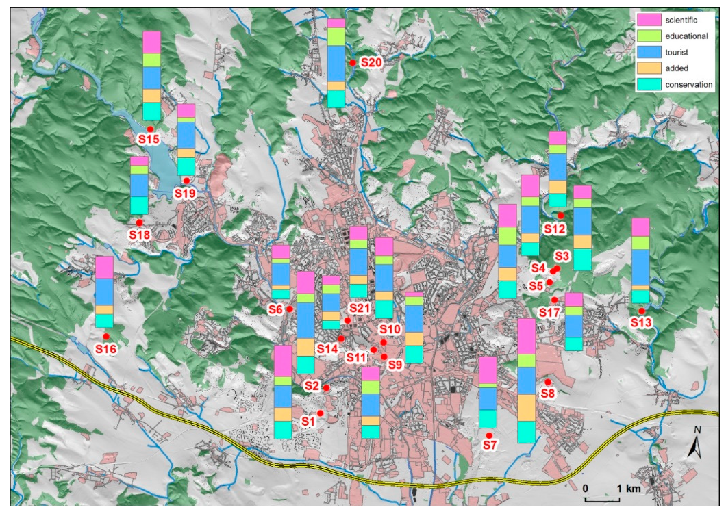
2.2. Study Area and Selected Anthropogenic Landforms
3. Results
3.1. Results of the Assessment
3.1.1. Scientific Values
3.1.2. Educational Values
3.1.3. Tourist Values
3.1.4. Added Values
3.1.5. Conservation Values
3.1.6. Total Values
3.2. Proposals for the Management of the Anthropogenic Landforms
4. Discussion
5. Conclusions
- -
- Anthropogenic landforms can achieve high scientific value, they can be included in the natural and cultural heritage and thus can be the subject of conservation efforts;
- -
- Setting legal protection for these sites ensures their acceptance by urban strategic planning and development;
- -
- The educational value of anthropogenic landforms within urban areas should be reconsidered and accepted as an important resource for on-site learning, and for both formal and informal education;
- -
- Anthropogenic landforms possess the potential for the development of sustainable forms of tourism—they can represent an interesting alternative to the traditional tourist destinations, and as such they should also be treated as a tourist resource;
- -
- Anthropogenic landforms are typical for their close relationship between natural and cultural features. The promotion of the links between scientific and added (cultural) values may help in the acceptance of the need for conservation measures by local communities and authorities.
Author Contributions
Funding
Conflicts of Interest
References
- Machar, I. Changes in ecological stability and biodiversity in a floodplain landscape. In Applying Landscape Ecology in Conservation and Management of the Floodplain Forest (Czech Republic); Accession Number: WOS:000325436900004; Machar, I., Ed.; Palacky University: Olomouc, Czech Republic, 2012; pp. 73–87. ISBN 978-80-244-2997-7. [Google Scholar]
- Hooke, R.L.; Martín-Duque, J.F. Land transformation by humans: A review. GSAT 2012, 22, 4–10. [Google Scholar] [CrossRef]
- Nir, D. Man, a geomorphological agent: An introduction to anthropic geomorphology. Earth Surf. Process. Landf. 1985, 10, 418. [Google Scholar]
- Goudie, A. The Human Impact on the Natural Environment: Past, Present and Future, 6th ed.; Blackwell Publishing: Hoboken, NJ, USA, 2006; ISBN 978-1-4051-2704-2. [Google Scholar]
- Oprsal, Z.; Harmacek, J.; Pavlik, P.; Machar, I. What factors can influence the expansion of protected areas around the world in the context of international environmental and development goals? Probl. Ekorozw. 2018, 13, 145–157. [Google Scholar]
- Szabó, J.; Dávid, L.; Lóczy, D. Anthropogenic Geomorphology: A Guide to Man-Made Landforms; Springer: Dordrecht, The Netherlands, 2010; ISBN 978-90-481-3057-3. [Google Scholar]
- Kilianova, H.; Pechanec, V.; Brus, J.; Kirchner, K.; Machar, I. Analysis of the development of land use in the Morava River floodplain, with special emphasis on the landscape matrix. Morav. Geogr. Rep. 2017, 25, 46–59. [Google Scholar] [CrossRef]
- Niemiec, D.; Duraj, M.; Marschalko, M.; Yilmaz, I. Conservation of Selected Churches in the Most Region and Karviná Region and their Significance for Geotourism. Procedia Eng. 2016, 161, 2276–2281. [Google Scholar] [CrossRef]
- Pechanec, V.; Machar, I.; Pohanka, T.; Oprsal, Z.; Petrovic, F.; Svajda, J.; Salek, L.; Chobot, K. Effectiveness of Natura 2000 system for habitat types protection: A case study from the Czech Republic. Nat. Conserv. Bulg. 2018, 24, 21–41. [Google Scholar] [CrossRef]
- Goudie, A.S. Anthropogenic landforms. In Encyclopedia of Geomorphology; Goudie, A.S., Ed.; Taylor & Francis: Milton Park, UK, 2006; p. 1202. ISBN 0-415-32737-7. [Google Scholar]
- Li, J.; Yang, L.; Pu, R.; Liu, Y. A review on anthropogenic geomorphology. J. Geogr. Sci 2017, 27, 109–128. [Google Scholar] [CrossRef]
- Kubalíková, L.; Kirchner, K.; Bajer, A. Secondary Geodiversity and its Potential for Urban Geotourism: A Case Study from Brno City, Czech Republic. Quaest. Geogr. 2017, 36, 63–73. [Google Scholar] [CrossRef]
- Prosser, C.D. Active quarrying and conservation. Earth Sci. Conserv. 1992, 31, 22–24. [Google Scholar]
- Prosser, C.D.; Larwood, J. Urban site conservation—An area to build on? In Geological and Landscape Conservation; O’Halloran, D., Green, C., Harley, M., Stanley, M., Knill, J., Eds.; Geological Society: London, UK, 1994; pp. 347–352, Accession Number: WOS: A1994BB84A00068. [Google Scholar]
- Parkes, M.; Gatley, S. Quarrying and Geoconservation in the Republic of Ireland—The Effectiveness of Guidelines for Operators. Geoheritage 2018, 10, 1–9. [Google Scholar] [CrossRef]
- Kopecka, V.; Machar, I.; Bucek, A.; Kopecky, A. The Impact of Climate Changes on Sugar Beet Growing Conditions in the Czech Republic. Listy Cukrov. Reparske 2013, 129, 326–329. [Google Scholar]
- Machar, I. Conservation and Management of Floodplain Forests in the Protected Landscape Area Litovelske Pomoravi (Czech Republic) Introduction. In Conservation and Management of Floodplain Forests in the Protected Landscape Area Litovelske Pomoravi (Czech Republic); Machar, I., Ed.; Palacky University: Olomouc, Czech Republic, 2009; pp. 7–108, Accession Number: WOS: 000331015800001; ISBN 978-80-244-2355-5. [Google Scholar]
- Betard, F. Patch-Scale Relationships Between Geodiversity and Biodiversity in Hard Rock Quarries: Case Study from a Disused Quartzite Quarry in NW France. Geoheritage 2013, 5, 59–71. [Google Scholar] [CrossRef]
- Beranova, L.; Balej, M.; Raska, P. Assessing the geotourism potential of abandoned quarries with multitemporal data (České Středohoří Mts., Czechia). GeoScape 2017, 11, 93–111. [Google Scholar] [CrossRef]
- Kirchner, K.; Kubalikova, L.; Machar, I. Assessment of anthropogenic landforms for the geotourism purposes (case study: Velké Opatovice fortification site, Archdiocese of Olomouc, Czech Republic). In Proceedings of the Public Recreation and Landscape Protection—With Nature Hand in Hand, Mendel University in Brno, Kitiny, Czech Republic, 2–4 May 2018; pp. 61–68, Accession Number: WOS:000434239900009. [Google Scholar]
- Machar, I.; Vozenilek, V.; Simon, J.; Pechanec, V.; Brus, J.; Fulnecek, P.; Vitek, T. Joining of the historical research and future prediction as a support tool for the assessment of management strategy for European beech-dominated forests in protected areas. Nat. Conserv. Bulg. 2017, 22, 51–78. [Google Scholar] [CrossRef]
- Gordon, J.E. Geoheritage, Geotourism and the Cultural Landscape: Enhancing the Visitor Experience and Promoting Geoconservation. Geosciences 2018, 8, 136. [Google Scholar] [CrossRef]
- Miles, E. Involving local communities and volunteers in geoconservation across Herefordshire and Worcestershire, UK—The Community Earth Heritage Champions Project. Proc. Geol. Assoc. 2013, 124, 691–698. [Google Scholar] [CrossRef]
- Kilianova, H.; Pechanec, V.; Svobodova, J.; Machar, I. Analysis of the evolution of the floodplain forests in the aluvium of the Morava river. In Proceedings of the 12th International Multidisciplinary Scientific Geoconference, SGEM 2012, Vol. IV, Albena, Bulgaria, 17–23 June 2012; pp. 1–8, Accession Number: WOS:000348535300001. ISSN 1314-2704. [Google Scholar]
- Swetnam, R.D.; Tweed, F.S. A tale of two landscapes: Transferring landscape quality metrics from Wales to Iceland. Land Use Policy 2018, 76, 565–576. [Google Scholar] [CrossRef]
- López-García, J.A.; Oyarzun, R.; López Andrés, S.I.; Manteca Martínez, J. Scientific, Educational and Environmental Considerations Regarding Mine Sites and Geoheritage: A Perspective from SE Spain. Geoheritage 2011, 3, 267–275. [Google Scholar] [CrossRef]
- Margiotta, S.; Sanso, P. Abandoned Quarries and Geotourism: An Opportunity for the Salento Quarry District (Apulia, Southern Italy). Geoheritage 2016, 9, 1–15. [Google Scholar] [CrossRef]
- Baczyńska, E.; Lorenc, M.W.; Kaźmierczak, U. The Landscape Attractiveness of Abandoned Quarries. Geoheritage 2018, 10, 271–285. [Google Scholar] [CrossRef]
- Mata-Perelló, J.; Carrión, P.; Molina Escobar, J.; Villas-Boas, R. Geomining Heritage as a Tool to Promote the Social Development of Rural Communities. In Geoheritage: Assessment, Protection and Management; Reynard, E., Brilha, J., Eds.; Elsevier: Amsterdam, The Netherland, 2018; pp. 167–177. ISBN 978-0-12-809531-7. [Google Scholar]
- Evans, B.G.; Cleal, C.J.; Thomas, B.A. Geotourism in an Industrial Setting: The South Wales Coalfield Geoheritage Network. Geoheritage 2018, 10, 93–107. [Google Scholar] [CrossRef]
- Osborne, R. Presidential Address for 1999–2000 geodiversity: “green” geology in action. Proc. Linn. Soc. New South Wales 2000, 122, 149–173, Accession Number: WOS:000169255200011. [Google Scholar]
- Petersen, J.F. The role of roadcuts, quarries and other artificial exposures in geomorphology education. Geomorphology 2002, 47, 289–301. [Google Scholar] [CrossRef]
- Prosser, C.D. Geoconservation, Quarrying and Mining: Opportunities and Challenges Illustrated Through Working in Partnership with the Mineral Extraction Industry in England. Geoheritage 2018, 10, 259–270. [Google Scholar] [CrossRef]
- Battisti, C. Habitat fragmentation, fauna and ecological network planning: Toward a theoretical conceptual framework. Ital. J. Zool. 2003, 70, 241–247. [Google Scholar] [CrossRef]
- Salekl, L.; Sivacioglu, A.; Topacoglu, O.; Zahradnile, D.; Jerabkoval, L.; Machar, I. Crowns of Old Remnant Oak Standards. Fresenius Environ. Bull. 2017, 26, 4023–4032. [Google Scholar]
- Simon, J.; Machar, I.; Brus, J.; Pechanec, V. Combining a growth-simulation model with acoustic-wood tomography as a decision-support tool for adaptive management and conservation of forest ecosystems. Ecol. Inf. 2015, 30, 309–312. [Google Scholar] [CrossRef]
- UNESCO. Operational Guidelines for the Implementation of the World Heritage Convention; UNESCO: Paris, France, 2017. [Google Scholar]
- Pica, A.; Vergari, F.; Fredi, P.; Monte, M. The Aeterna Urbs Geomorphological Heritage (Rome, Italy). Geoheritage 2015, 8, 1–12. [Google Scholar] [CrossRef]
- Reynard, E.; Pica, A.; Coratza, P. Urban Geomorphological Heritage. An Overview. Quaestiones Geographicae 2017, 36, 7–20. [Google Scholar] [CrossRef]
- UNESCO. Convention Concerning the Protection of the World Cultural and Natural Heritage; UNESCO: Paris, France, 1972. [Google Scholar]
- Ahmad, S.; Jones, D. Investigating the Mining Heritage Significance for Kinta District, the Industrial Heritage Legacy of Malaysia. Procedia Soc. Behav. Sci. 2013, 105, 445–457. [Google Scholar] [CrossRef]
- Conlin, M.V.; Jolliffe, L. Mining Heritage and Tourism: A Global Synthesis; Routledge: London, UK; New York, NY, USA, 2011; ISBN 978-0-203-86550-7. [Google Scholar]
- Pearson, M.; Mcgowan, B. Mining Heritage Places Assessment Manual; Australian Council of National Trusts and the Australian Heritage Commission: Canberra, Australia, 2000; ISBN 0-908-19815-9. [Google Scholar]
- Portal, C.; Kerguillec, R. The Shape of a City: Geomorphological Landscapes, Abiotic Urban Environment and Geoheritage in the Western World: The Example of Parks and Gardens. Geoheritage 2017, 67–78. [Google Scholar] [CrossRef]
- Habibi, T.; Ponedelnik, A.A.; Yashalova, N.; Ruban, D.A. Urban geoheritage complexity: Evidence of a unique natural resource from Shiraz city in Iran. Resour. Policy 2018, 59. [Google Scholar] [CrossRef]
- Reynard, E.; Giusti, C. The Landscape and the Cultural Value of Geoheritage. In Geoheritatge: Assessment, Protection and Management; Reynard, E., Brilha, J., Eds.; Elsevier: Amsterdam, The Netherland, 2018; pp. 147–166. ISBN 978-0-12-809531-7. [Google Scholar]
- Coratza, P.; Hobléa, F. The Specificities of Geomorphological Heritage. In Geoheritage: Assessment, Protection and Management; Reynard, E., Brilha, J., Eds.; Elsevier: Amsterdam, The Netherland, 2018; pp. 87–106. ISBN 978-0-12-809531-7. [Google Scholar]
- Reynard, E.; Panizza, M. Geomorphosites: Definition, assessment and mapping. An introduction. Géomorphologie Relief Process. Environ. 2005, 11, 177–180. [Google Scholar]
- Boukhchim, N.; Fraj, T.B.; Reynard, E. Lateral and “Vertico-Lateral” Cave Dwellings in Haddej and Guermessa: Characteristic Geocultural Heritage of Southeast Tunisia. Geoheritage 2017, 1–16. [Google Scholar] [CrossRef]
- Pereira, P.; Pereira, D.; Alves, M. Geomorphosite assessment in Montesinho Natural Park (Portugal). Geogr. Helv. 2007, 62, 159–168. [Google Scholar] [CrossRef]
- Reynard, E.; Perret, A.; Bussard, J.; Grangier, L.; Martin, S. Integrated Approach for the Inventory and Management of Geomorphological Heritage at the Regional Scale. Geoheritage 2015, 8, 43–60. [Google Scholar] [CrossRef]
- Pica, A.; Luberti, G.M.; Vergari, F.; Fredi, P.; Del Monte, M. Contribution for an Urban Geomorphoheritage Assessment Method: Proposal from Three Geomorphosites in Rome (Italy). Quaest. Geogr. 2017, 36, 21–36. [Google Scholar] [CrossRef]
- Coratza, P.; Giusti, C. Methodological proposal for the assessment of the scientific quality of geomorphosites. IL Quat. 2005, 18, 305–311. [Google Scholar]
- Pralong, J.P. A method for assessing tourist potential and use of geomorphological sites. Géomorphologie Relief Process. Environ. 2005, 11, 189–196. [Google Scholar] [CrossRef]
- Reynard, E.; Fontana, G.; Kozlik, L.; Scapozza, C. A method for assessing “scientific” and “additional values” of geomorphosites. Geogr. Helv. 2007, 62, 148–158. [Google Scholar] [CrossRef]
- Pereira, P.; Pereira, D. Methodological guidelines for geomorphosite assessment. Géomorphologie Relief Process. Environ. 2010, 16, 215–222. [Google Scholar] [CrossRef]
- Fassoulas, C.; Mouriki, D.; Dimitriou, P.; Iliopoulos, G. Quantitative Assessment of Geotopes as an Effective Tool for Geoheritage Management. Geoheritage 2012, 4, 177–193. [Google Scholar] [CrossRef]
- Bollati, I.; Smiraglia, C.; Pelfini, M. Assessment and selection of geomorphosites and trails in the Miage Glacier area (Western Italian Alps). Environ. Manag. 2013, 51, 951–967. [Google Scholar] [CrossRef]
- Kubalíková, L.; Kirchner, K. Geosite and Geomorphosite Assessment as a Tool for Geoconservation and Geotourism Purposes: A Case Study from Vizovická vrchovina Highland (Eastern Part of the Czech Republic). Geoheritage 2016, 8, 5–14. [Google Scholar] [CrossRef]
- Suzuki, D.A.; Takagi, H. Evaluation of Geosite for Sustainable Planning and Management in Geotourism. Geoheritage 2017, 1–13. [Google Scholar] [CrossRef]
- Uña-Álvarez, E.D.; Álvarez Vázquez, M.Á.; Cuquejo-Bello, M.D.C. Landform values for rural sustainability: Recognition and assessment in a Spanish-Portuguese border region case study. Morav. Geogr. Rep. 2017, 25, 257–270. [Google Scholar] [CrossRef]
- Peña, L.; Monge-Ganuzas, M.; Onaindia, M.; De Manuel, B.F.; Mendia, M. A Holistic Approach Including Biological and Geological Criteria for Integrative Management in Protected Areas. Environ. Manag. 2017, 59, 325–337. [Google Scholar] [CrossRef]
- Rypl, J.; Kirchner, K.; Ryplova, R. Contribution to the Assessment of Geomorphosites in the Czech Republic (a Case Study of the North-eastern Part of the Novohradské Mountains). Geoheritage 2019, 11, 427–439. [Google Scholar] [CrossRef]
- Bruschi, V.M.; Cendrero, A.; Cuesta-Albertos, J. A Statistical Approach to the Validation and Optimisation of Geoheritage Assessment Procedures. Geoheritage 2011, 3, 131–149. [Google Scholar] [CrossRef]
- Kubalíková, L. Geomorphosite assesment for geotourism purposes. Czech J. Tour. 2013, 2, 80–104. [Google Scholar] [CrossRef]
- Štrba, L.; Rybár, P.; Baláž, B.; Molokáč, M.; Hvizdák, L.; Kršák, B.; Lukáč, M.; Muchová, L.; Tometzová, D.; Ferenčíková, J. Geosite assessments: Comparison of methods and results. Curr. Issues Tour. 2015, 18, 496–510. [Google Scholar] [CrossRef]
- Brilha, J. Inventory and Quantitative Assessment of Geosites and Geodiversity Sites: A Review. Geoheritage 2016, 8, 119–134. [Google Scholar] [CrossRef]
- Zwolinski, Z.; Najwer, A.; Giardino, M. Methods for assessing geodiversity. In Geoheritage: Assessment, Protection and Management; Reynard, E., Brilha, J., Eds.; Elsevier: Amsterdam, The Netherland, 2018; pp. 27–52. ISBN 978-0-12-809531-7. [Google Scholar]
- Panizza, M.; Piacente, S. Geomorphosites: A bridge between scientific research, cultural integration and artistic suggestion. Quaternario 2005, 18, 3–10. [Google Scholar]
- Panizza, M.; Piacente, S. Geomorphosites and geotourism. Rev. Geográfica Acadêmica 2008, 2, 5–9. [Google Scholar] [CrossRef][Green Version]
- Newsome, D.; Dowling, R. Geotourism: The Tourism of Geology and Landscape; Goodfellow Pub Ltd.: Oxford, UK, 2010; ISBN 978-1-906884-09-3. [Google Scholar]
- Dowling, R.K. Global geotourism—An emerging form of sustainable tourism. Czech J. Tour. 2013, 2, 59–79. [Google Scholar] [CrossRef]
- Hose, T. 3G’s for Modern Geotourism. Geoheritage 2012, 4, 7–24. [Google Scholar] [CrossRef]
- Linstone, H.A.; Turoff, M. Delphi: A brief look backward and forward. Technol. Forecast. Soc. Chang. 2011, 78, 1712–1719. [Google Scholar] [CrossRef]
- Battisti, C.; Luiselli, L. Selecting focal species in ecological network planning following an expert-based approach: Italian reptiles as a case study. J. Nat. Conserv. 2011, 19, 126–130. [Google Scholar] [CrossRef]
- Amici, V.; Geri, F.; Battisti, C. An integrated method to create habitat suitability models for fragmented landscapes. J. Nat. Conserv. 2010, 18, 215–223. [Google Scholar] [CrossRef]
- Prosser, C.; Bridgland, D.R.; Brown, E.; Larwood, J. Geoconservation for science and society: Challenges and opportunities. Proc. Geol. Assoc. Proc. Geol. Assoc. 2011, 122, 337–342. [Google Scholar] [CrossRef]
- Farsani, N.T.; de Carvalho, C.N.; Xu, K. Education as a key tenet of geotourism. In Handbook of Geotourism; Dowling, R.K., Newsome, D., Eds.; Edward Elgar Publishing: Cheltenham, UK, 2018; pp. 234–243. [Google Scholar] [CrossRef]
- Panizza, M. Geomorphosites: Concepts, methods and examples of geomorphological survey. Chin. Sci. Bull. 2001, 46, 4–6. [Google Scholar] [CrossRef]
- Salafsky, N.; Salzer, D.; Stattersfield, A.J.; Hilton-Taylor, C.; Neugarten, R.; Butchart, S.H.M.; Collen, B.; Cox, N.; Master, L.L.; O’Connor, S.; et al. standard lexicon for biodiversity conservation: Unified classifications of threats and actions. Conserv. Biol. 2008, 22, 897–911. [Google Scholar] [CrossRef]
- Novák, Z. Geologická Mapa 1:50 000 List 24–32; Český Geologický Ústav: Brno, Czech Republic, 1991. [Google Scholar]
- Müller, P.; Novák, Z. Geologie Brna a Okolí; Český geologický ústav Praha: Praha, Czech Public, 2000; ISBN 80-7075-416-8. [Google Scholar]
- Kovarik, P.; Kutal, M.; Machar, I. Sheep and wolves: Is the occurrence of large predators a limiting factor for sheep grazing in the Czech Carpathians? J. Nat. Conserv. 2014, 22, 479–486. [Google Scholar] [CrossRef]
- Demek, J.; Mackovčin, P.; Balatka, B.; Buček, A.; Culek, M.; Čermák, P.; Dobiáš, D.; Havlíček, M.; Hrádek, M.; Kirchner, K.; et al. Zeměpisný Lexikon ČR. Hory a Nížiny; Mendelova univerzita v Brně: Brno, Czech Public, 2015; ISBN 978-80-7509-113-0. [Google Scholar]
- Machar, I.; Vozenilek, V.; Kirchner, K.; Vlckova, V.; Bucek, A. Biogeographic model of climate conditions for vegetation zones in Czechia. Geografie 2017, 122, 64–82. [Google Scholar]
- Parma, D.; Vejrostova, L.; Lisa, L.; Bajer, A.; Pacina, J.; Gottvald, Z. Neolithic Occupation of Svratka Alluvial Plain; Case Study from Brno-Přízřenice, Czech Republic. Interdiscip. Archaeol. 2015, 6, 181–193. [Google Scholar] [CrossRef]
- Lisa, L.; Peska, M.; Merta, D.; Gregor, M. Maintenance of Underground Granaries in Medieval Towns; Case Study from Padowetz, Brno, Czech Republic. Interdiscip. Archaeol. 2017, 8, 157–165. [Google Scholar] [CrossRef]
- Machar, I.; Simon, J.; Rejsek, K.; Pechanec, V.; Brus, J.; Kilianova, H. Assessment of Forest Management in Protected Areas Based on Multidisciplinary Research. Forests 2016, 7, 11. [Google Scholar] [CrossRef]
- Brus, J.; Pechanec, V.; Machar, I. Depiction of uncertainty in the visually interpreted land cover data. Ecol. Inform. 2018, 47, 10–13. [Google Scholar] [CrossRef]
- Machar, I. Attempt to Summarize the Problems: Is a Sustainable Management of Floodplain Forest Geobiocenoses Possible? In Biodiversity and Target Management of Floodplain Forests in the Morava River Basin (Czech Republic); Machar, I., Ed.; Palacky University: Olomouc, Czech Republic, 2010; pp. 189–226. ISBN 978-80-244-2530-6. [Google Scholar]
- Nehyba, S.; Kirchner, K.; Tomanová-Petrová, P. Nové odkryvy fluviálních sedimentů v prostoru Brno- Bystrc. Geologické Výzkumy na Moravě a ve Slezsku v Roce 2008, 2007, 36–40. [Google Scholar]
- Powell, J.H.; Nash, G.; Bell, P. GeoExposures: Documenting temporary geological exposures in Great Britain through a citizen-science web site. Proc. Geol. Assoc. 2013, 124, 638–647. [Google Scholar] [CrossRef]
- Dunlop, L. Rescue Geology—Taking Advantage of Temporary Exposures. In Proceedings of the 20th EGU General Assembly, EGU2018, Vienna, Austria, 4–13 April 2018; p. 16264. [Google Scholar]
- Florenzano, A.; Mercuri, A.M.; Fornaciari, R.; Garcea, E.A.A. Plants, water and humans: Pollen analysis from Holocene archaeological sites on Sai Island, northern Sudan. Palynology 2019, 43, 22–33. [Google Scholar] [CrossRef]
- Mercuri, A.M.; Florenzano, A. The long-term perspective of human impact on landscape for environmental change (LoTEC) and sustainability: From botany to the interdisciplinary approach. Sustainability 2019, 11, 413. [Google Scholar] [CrossRef]
- Florenzano, A. The History of Pastoral Activities in S Italy Inferred from Palynology: A Long-Term Perspective to Support Biodiversity Awareness. Sustainability 2019, 11, 404. [Google Scholar] [CrossRef]
- Cocean, G.; Cocean, P. An Assessment of Gorges for Purposes of Identifying Geomorphosites of Geotourism Value in the Apuseni Mountains (Romania). Geoheritage 2016, 9, 71–81. [Google Scholar] [CrossRef]
- Olafsdottir, R.; Tverijonaite, E. Geotourism: A Systematic Literature Review. Geosciences 2018, 8, 234. [Google Scholar] [CrossRef]
- Pechanec, V.; Brus, J.; Kilianova, H.; Machar, I. Decision support tool for the evaluation of landscapes. Ecol. Inform. 2015, 30, 305–308. [Google Scholar] [CrossRef]
- Madera, P.; Machala, M.; Slach, T.; Friedl, M.; Cernusakova, L.; Volarik, D.; Bucek, A. Predicted occurrence of ancient coppice woodlands in the Czech Republic. Iforest Biogeosci. For. 2017, 10, 788–795. [Google Scholar] [CrossRef]


| Values | Criteria/Questions | Numerical Assessment Proposal |
|---|---|---|
| Scientific value | Integrity or current status of the site: related to the conservation status of the main elements | 1—conserved 0.5—partly conserved 0—damaged |
| Diversity of the Earth science features: a number of different elements with scientific interest | 1—4 and more different features 0.5—2–3 features 0—1 feature | |
| Rarity: number of similar sites in the area of study | 1—the site is unique within study area 0.5—there are 2 or 3 similar sites 0—more than 3 similar sites | |
| Scientific knowledge of the site: the existence of published scientific studies about the site | 1—world known site 0.5—regionally/nationally known site, several scientific papers 0—the site has been researched marginally | |
| Educational value | Exemplarity and representativeness: capacity of a site to illustrate Earth science elements or processes, possibility for people with no geological background to understand the elements and processes | 1—good exemplarity and representativeness of the features 0.5—features are comprehensible, but short explication is needed 0—features are not legible to the lay public; professional explication is needed |
| Presence of educational facilities, e.g., educational trails or information panels | 1—presence of educational trails or information panels with relevant information 0.5—existing educational facilities but with limited information 0—no educational facilities on the site | |
| Tourist value | Accessibility | 1—access without problems 0.5—limited access (e.g., only with permission or with special equipment) 0—site is inaccessible to the public (or access is possible at own risk) |
| Safety: high or low risk conditions for visitors | 1—safety is not a problem 0.5—some specific limitation (e.g., the risk of landslides) 0—visiting site is not recommended and it is dangerous | |
| Tourist infrastructure: facilities for receiving tourists (accommodation, food, toilets) | 1—tourist infrastructure situated within walking distance 0.5—limited tourist infrastructure is accessible 0—no tourist infrastructure | |
| Viewpoints and visibility: the conditions for observation of all the elements on the site | 1—more than 3 different viewpoints 0.5—1–3 viewpoints 0—no viewpoint, the visibility is limited | |
| Added value | Ecological aspect: the relevance from the ecological or biological point of view (e.g., species/ecosystems that exist here due to the existence of landform/anthropogenic activity) | 1—yes, there are some specific ecological features 0—without specific ecological features |
| Cultural aspects: a number of different cultural aspects (e.g., historical aspect—evidence of social/economic/industrial changes and development; artistic aspect—site as an inspiration for artists; architectonical aspect—visible evidence of the use of material especially from mining landforms; presence of religious features on the site; geomythological aspect—myths about the site; technical aspects etc.) | 2—5 and more different cultural aspects 1.5—4 different cultural aspects 1—3 different cultural aspects 0.5—2 different cultural aspects 0—1 cultural aspect | |
| Conservation value | Existing legislative protection (site declared as natural monument or reservation, part of the large protected landscape area, protected as a significant landscape element, cultural protection etc.) | 1—existing legislative conservation 0.5—the site is proposed for conservation or is registered as an important landscape element 0—no legal protection or proposals for conservation |
| Current threats [80]: the existence of any threats that can lead to the damage of the site (both natural respectively natural threats induced or supported by human activity that can lead to the destruction of a site or its degradation or disappearance of specific geo-features, e.g., vegetation growth, invasive species, landslides) and anthropogenic (e.g., dump fill, vandalism, “revitalization” that can cause disappearance of specific Earth science and related features) | 2—no threats, risks or hazards 1.5—existing threats, but the risk is low or already being managed 1—existing threats with an average or high risk, but there is a certain conception how to manage them or how to mitigate the impacts 0.5—existing threats with high risks which are not managed and resolved 0—currently the site is in danger, there are some processes that can lead to its devastation |
| Number and Name | Type of Anthropogenic Geomorphosite and Short Characteristics |
|---|---|
| S1 Červený kopec A | mining (loess pit) |
| S2 Červený kopec B | mining (conglomerate and sandstone quarries) |
| S3 Hády—plain | mining (medieval Devonian limestone quarries) |
| S4 Hády—upper bench | mining (recent Jurassic/Devonian limestone quarry) |
| S5 Hády—Růženin lom | mining (limestone and granitoid quarry), communication/industrial (tunnels) |
| S6 Žabovřesky quarry | mining (metabasalt quarry) |
| S7 Černovice sandpit | mining (sand pit with occurrence of clays and gravels) |
| S8 Stránská skála | mining (Jurassic limestone quarry) and industrial (underground factories) |
| S9 Zelný trh—labyrinth | residential (system of cellars) |
| S10 Ossuary of St. James Church | funeral (underground spaces) |
| S11 Bunker 10-Z | military (war or nuclear bomb shelter) |
| S12 Obřany castle | residential/military (ramparts, banks, trenches), communication/traffic (old hollow ways) |
| S13 Říčka valley | water management (reservoirs, millraces, boreholes, wells) |
| S14 Water reservoirs Tvrdého | water management (underground water reservoirs) |
| S15 Abrasion cliffs at Brno dam | water management/littoral (abrasion cliffs in loess) |
| S16 Bosonožský hájek | agricultural (terraces), communication/traffic (old hollow ways) |
| S17 Jedovnická street cutting | communication/traffic (road cutting in granodiorites) |
| S18 Vejrostova street cutting | communication/traffic (road cutting in the rocks of Brno massif) |
| S19 Old highway | communication/traffic (artificial communication embankments) |
| S20 Tišnovka railway | communication/traffic (remains of railway embankments) |
| S21 Úvoz | urban/communication (outcrops of the rocks of Brno massif which has been considerably remodelled by human activity—the part of the site does not exist due to road construction) |
| Sites | Scientific Value | Educational Value | Tourist Value | Added Value | Conservation Value | Total Value |
|---|---|---|---|---|---|---|
| S1 (Červený kopec A) | 3.5 | 1 | 2.5 | 1.5 | 2 | 10.5 |
| S2 (Červený kopec B) | 2.5 | 1 | 4 | 2 | 2 | 11.5 |
| S3 (Hády—plain) | 1.5 | 1 | 3 | 1.5 | 2.5 | 9.5 |
| S4 (Hády—upper bench) | 2.5 | 1 | 3 | 1 | 1.5 | 9 |
| S5 (Hády—Růženin lom) | 2.5 | 2 | 2.5 | 1.5 | 2 | 10.5 |
| S6 (Žabovřesky quarry) | 1.5 | 0.5 | 2.5 | 0.5 | 1 | 6 |
| S7 (Černovice sandpit) | 3 | 0.5 | 2.5 | 0 | 2 | 8 |
| S8 (Stránská skála) | 4 | 1.5 | 3 | 3 | 2.5 | 14 |
| S9 (Zelný trh—labyrinth) | 0.5 | 1 | 3 | 1.5 | 2 | 8 |
| S10 (Ossuary St. James) | 2 | 1 | 3 | 1 | 2 | 9 |
| S11 (Bunker 10-Z) | 1.5 | 1.5 | 2.5 | 1 | 1.5 | 8 |
| S12 (Obřany castle) | 1.5 | 1 | 3 | 1.5 | 1.5 | 8.5 |
| S13 (Říčka valley) | 2 | 1.5 | 4 | 0.5 | 1.5 | 9.5 |
| S14 (Water reservoirs Tvrdého) | 1 | 1 | 2 | 1 | 1 | 6 |
| S15 (Abrasion cliffs at Brno dam) | 2.5 | 1.5 | 2.5 | 1.5 | 2 | 10 |
| S16 (Bosonožský hájek) | 2.5 | 0 | 3 | 1 | 1.5 | 8 |
| S17 (Jedovnická street cutting) | 1.5 | 1 | 2.5 | 0 | 1.5 | 6.5 |
| S18 (Vejrostova street cutting) | 1 | 1 | 2.5 | 0 | 2 | 6.5 |
| S19 (Old highway) | 1.5 | 0.5 | 3 | 1 | 2 | 8 |
| S20 (Tišnovka railway) | 1 | 2 | 4 | 1 | 2 | 10 |
| S21 (Úvoz) | 1.5 | 1 | 3 | 1 | 1.5 | 8 |
© 2019 by the authors. Licensee MDPI, Basel, Switzerland. This article is an open access article distributed under the terms and conditions of the Creative Commons Attribution (CC BY) license (http://creativecommons.org/licenses/by/4.0/).
Share and Cite
Kubalikova, L.; Kirchner, K.; Kuda, F.; Machar, I. The Role of Anthropogenic Landforms in Sustainable Landscape Management. Sustainability 2019, 11, 4331. https://doi.org/10.3390/su11164331
Kubalikova L, Kirchner K, Kuda F, Machar I. The Role of Anthropogenic Landforms in Sustainable Landscape Management. Sustainability. 2019; 11(16):4331. https://doi.org/10.3390/su11164331
Chicago/Turabian StyleKubalikova, Lucie, Karel Kirchner, Frantisek Kuda, and Ivo Machar. 2019. "The Role of Anthropogenic Landforms in Sustainable Landscape Management" Sustainability 11, no. 16: 4331. https://doi.org/10.3390/su11164331
APA StyleKubalikova, L., Kirchner, K., Kuda, F., & Machar, I. (2019). The Role of Anthropogenic Landforms in Sustainable Landscape Management. Sustainability, 11(16), 4331. https://doi.org/10.3390/su11164331