Article

Land Cover Changes Induced by Demining Operations in Halgurd-Sakran National Park in the Kurdistan Region of Iraq

1
Faculty of Science, Department of Petroleum Geosciences, Delzyan Campus, Soran University, Soran 44008, Erbil, Iraq
2
Scientific Research Centre, Delzyan Campus, Soran University, Soran 44008, Erbil, Iraq
3
Centre for Landscape and Climate Research (CLCR), School of Geography, Geology and the Environment, University of Leicester, University Road, Leicester LE1 7RH, UK
4
National Centre for Earth Observation, University of Leicester, University Road, Leicester LE1 7RH, UK
*
Author to whom correspondence should be addressed.
Sustainability 2018, 10(7), 2422; https://doi.org/10.3390/su10072422
Submission received: 20 May 2018 / Revised: 25 June 2018 / Accepted: 3 July 2018 / Published: 11 July 2018
(This article belongs to the Section Sustainable Agriculture)

Abstract

:
This study presents an analysis of Landsat data to quantify how the deployment of landmines and demining operations in the first national park in Iraq, the Halgurd-Sakran Core Zone (HSCZ) in the Kurdistan region, has altered the vegetation/land cover patterns over 17 years (between 1998 and 2015). Post-war impacts of landmines on land cover fragmentation and degradation in HSCZ are examined using GIS and remote sensing. Landmines fundamentally change the available land use options for local communities by limiting access to the land. Their widespread use in military conflicts around the world made investigating the impacts of minefields on land cover fragmentation the subject of scientific studies. The Iraqi-Iranian war (1980–1988) and subsequent conflicts have left behind densely mined areas in Kurdistan, especially in the border zones, which were previous battle zones. These leftover weapons of historic wars are indiscriminate and still affecting people. The results revealed that the relationship between land use/land cover (LULC) classes before and after the Fall of Baghdad is different for all classes, especially for pasture and cultivated lands. Between 1998 and 2015 the proportion of land covered by forest or under agricultural cultivation decreased substantially, matched by a large increase in pasture extent. The results also show that after 2003 increased attention has been paid to raising landmine awareness in the areas most affected by mines. Additionally, the landmines slowed down the progression in HSCZ, otherwise, agricultural production and productivity could potentially have doubled. The change in cultivated land area in the park does not relate to population growth but to the presence of minefields, minefield programme awareness, and socio-economic factors. Strong rural pull factors succeeded in bringing displaced people back to villages as a result of social progress, economic growth, and political stability in HSCZ.

1. Introduction

1.1. Impacts of War on the Environment

Anti-personnel and anti-vehicle landmines are two common types of mines. The existence of landmines, unexploded explosive ordnance, and other explosive devices presents long-term fears and challenges for local inhabitants, returnees, and governments. Generally, the mines from the battle and regional conflicts over 70 countries still continue to injure, maim, and kill the civilian population [1,2,3]. Some countries in the world are dramatically affected by anti-personnel landmines, for instance, Bosnia, Cambodia [4], Croatia [5], Iraq [6], Egypt [7], Afghanistan, and Angola [8]. Furthermore, Iraq is ranked as the fourth most heavily mined country by anti-personnel landmines per square mile [4]. Generally, the war maimed, displaced, and left thousands of homeless people all over the country between 1979 and 2003 [9].
The study area is located along the Iraqi-Iranian border and previously was a war zone [10]. However, the Kurdistan region of Iraq is one of the regions that has been most widely affected by deployed anti-personnel landmines over the last four decades [6,11]. The Halgurd-Sakran National Park with its three zones (core, outer, and additional outer) is one of the areas most affected by landmines and unexploded ordnance from the wars in the Kurdistan region, affecting agriculture, pastoralism, and undermining people’s ability to form a livelihood and achieve socio-economic development. Most previous landmine of Kurdistan Iranian border maps are non-existent due to the turmoil arising from long wars in the region. Nowadays, mine action activities in the Kurdistan region are currently coordinated by the Iraqi Kurdistan Mine Agency Action (IKMAA), which is the only agency that is conducting minefield survey, mapping, marking suspect areas, and using mass media for the whole Kurdistan region, particularly Halgurd-Sakran National Park (HSNP). Much progress has been made on collecting data and destroying mines through engineering groups that are involved in the clearance of minefields by IKMAA. Last but not the least, IKMAA aims to reduce deaths and injuries, and to allow displaced people to return home in relative safety following the end of the conflicts [11].
In general, the mines that have been left behind are harmful to societies, individuals, and the environment. Landmines do not differentiate between soldiers, civilians, and wildlife and are easy to lay, but pose huge difficulties in demining the affected areas afterwards. There are no accurate data on the number of landmines in the world [4,12]. Moreover, they are considered a significant problem for environmental and socio-economic issues, which destroys existing infrastructures [4,13].
One reason for unexploded ordnance accidents is the lack of knowledge, awareness, and information about the risks of landmines [14,15]. Numerous mine-risk education and awareness programs have been carried out in villages in the Kurdistan region. The mine awareness education (MAE) in the Kurdistan region was started by many organisations in the mid-1990s and intensified after the Fall of Baghdad in April 2003, in which it seeks to prevent harm to individuals and communities [11]. Furthermore, mine awareness education has been conducted to motivate people to share their knowledge with their communities and relatives [2]. Un-cleared landmines constitute a threat to whole societies and environments [16].
The restrictions which minefields imposed on land in the Halgurd-Sakran Core Zone cause the people to live in a contaminated landscape, and to have low accessibility to natural resources. The inhabitants have reduced biological diversity through the destruction of some plant and animal populations, pollution of the surrounding soil and water by the introduction of toxic materials, damage to the productivity and fertility of the soil constraining farming activities, and the undermining of the ecosystem itself. Furthermore, landmines negatively affect economic and social conditions. Mines pose a major risk to economic growth and lead to the local population living in fear [12,17,18,19]. Detonating mines triggered by humans, animals, or through the process of demining destroys the vegetation cover. Moreover, a fragmented mine also affects the bark or root of a plant when exploding, which leads to land degradation [20,21].

1.2. Soil Degradation Processes

Land-use/land-cover (LULC) change is a significant factor of ecological degradation in any landscape. Most areas of LULC categories are under threat from the pressure by human activities around the world in the last five decades [22]. In general, human demands and processes of natural degradation reduce the ability of ecosystems to provide ecosystem services [23]. However, one of the most important natural resources for crop production is the soil, which provides water and nutrients for plant growth. Globally, soil formation rates are estimated as nearly 2.5 cm every 150 years [24]. Moreover, in a typical healthy environment of silt loam soil, 50% of it will be composed of organic matter and soil particles, while the rest will be equally occupied 25% by air and 25% by water. The heavy machinery traffic will result in compacted soil, which affects negatively soil properties, such as destruction of soil structure, decreasing water infiltration, decreasing soil water storage, and decreasing the nutrients of the soil. All of these factor causes can result in increased soil erosion and decreased crop production [25,26].
Air, nutrients, and water are three vital elements for plant roots to be grown in soil. Soil structure is an important characteristic of the soil for plant nutrient uptake. Moreover, soil structure determines the ability of a soil to hold water, nutrients, and air necessary for plant root activity [24,27]. Furthermore, good structure reflects a healthy soil; therefore, structure is a significant defence against soil compaction. Roots are less able to penetrate the soil in a compacted soil, which has a high density; therefore the ability to exploit nutrients for soil would be limited. Smaller pore space leads to smaller amounts of aeration of the soil, which increases denitrification [28]. Physical, chemical, and biological degradation determine the functioning of the soil.
This study focused on physical soil degradation, which mainly leads to soil loss during the clearance of landmines by heavy equipment [27]. Physical loss and the reduction in quality of topsoil are two factors that cause soil degradation. Degraded soil has enormous impacts on the land and landscape as soil degradation adversely hinders plant growth and affects the productive capacity of the land [13,29]. Soil erosion leads to the weakening of Earth’s natural resources, by declining land productivity, loss of organic matter, and loss of plant nutrients and soil fertility [30]. Moreover, the removed top soil changes the crop yield, which indicated that the erosion-deposition process can significantly alter the soil nutrient status and soil productivity during the erosion events [31].
Soil compaction is a concern for land degradation due to increasing the resistance of plant roots to penetrate soil, which also leads to increasing the surface runoff and changes in the moisture content. Likewise, the total pore space decreases in a compacted soil, which influences the water movement characteristics that carry oxygen to roots, thus trees will have poor root systems [13,32,33].
Explosive remnants of war negatively impact the environment and degrade land by damaging and disrupting the soil structure [34]. Some removal methods employed by demining action organizations can lead to environmental degradation [35]. Moreover, mass movements and physical destruction by heavy machineries lead to loss of fertile top soil, thereby declining soil quality. Therefore, a durable peace cannot be achieved if the natural resources sustaining livelihoods and ecosystem services are damaged, degraded, or destroyed, stated Hoffman and Rapillard [34].

1.3. Rural–Urban and Urban–Rural Migration

Many conditions for effects lead to rural–urban migration such as social, economic, and political factors. These factors are the main factors of movement of people from countryside to the urban areas. “Migration is broadly defined as a relocation of residence for a specified duration and various reasons, which may be permanent in nature or it may be temporary” [36]. “Push” and “Pull” factors are two categorised factors that justify why people migrate from countryside to urban areas. Push factor means the reasons people leave rural places, while pull factor means the reasons people move to urban places [37,38]. They explain the processes that attract migrants to the new location [39].
During the “urban–rural” migration, throughout their staying in urban areas rural people often gain access to information and modern ways of thinking. Therefore, the rural landscape will change socially, economically, and demographically when they return to their former villages with better economic conditions [40]. It matters why people migrate from their places of origin and to know whether this is driven by push or pull factors [41].
Researchers have widely examined the impacts of landmines on socio-economic, agricultural, and environmental activities. Gebrehiwot and Kara [3] highlighted the benefits of demining in supporting economic development. Berhe [13] emphasised the role of explosion in destroying the vegetation cover. Gangwar [12] stated the impact of landmines on decreasing farmlands. Satterthwaite et al. [42] highlighted the poverty of food as a result of decreasing farm activities. Concerning the mine awareness program, Yadav [16] presented a continuous and incredible decrease in the number of victims due to the founding of various mine awareness program in Nepal. Misak and Omer [43] reported how heavy equipment effects the soil compaction during the mine clearance operations in Kuwait, as the compaction of soil is the main issue facing modern agriculture [44]. Further, they noticed the reduction of water infiltration rate into soils compared to un-affected soils. Simultaneously, the urbanisation problem was discussed by Patanaik et al. [45] who discovered that migration is not only causing social imbalance but also causing urbanisation problems. Jedwab et al. [46] offered an additional mechanism for urban growth “rural push” and “urban pull” factors, which based on an “urban push”. Thet [47] highlighted the main reasons of migration in Myanmar, which were to “gain better public service and upgrade living standard”.
To sum up, in order to provide a comprehensive knowledge during the post-conflict period in the area of interest, natural environmental resources, mine clearance operations, demographic trends, and socio-economic factors including the push–pull approach that influences the land cover vegetation should be considered.
How landmines influence the vegetation dynamics and land cover change in HSCZ has not been studied in sufficient detail. Remotely sensed images are a versatile tool for studying natural resources and the environment, which derives information and records the phenomena about the Earth’s surface [34]. The use of GIS, remote sensing, and landscape metrics on landscape fragmentation can be useful tools to develop a variety of maps [48]. GIS and remote sensing technologies assist widely in analysing land cover changes [35].
Halgurd-Sakran National Park is the first national park of Iraq, which is designated as a protected area with its three zones (core, outer, and additional outer) of different protection levels because of their biodiversity and ecological significance [48].
The objectives of our study were to (1) detect, quantify, and characterise the changes in land use/land cover between two points of the restricted landmine fields; and to (2) analyse causes that led to land cover changes and soil degradation.

2. Materials and Methods

2.1. Site Description

Halgurd-Sakran Core Zone is located northeast of Erbil, Iraq, in the Zagros Mountain Range, which shares a border with Iran. The climate of the study area is hot and dry in summer, and cold and wet in winter [47]. Figure 1 displays the Halgurd-Sakran national park with its three zones. The core and additional outer zones are covered by the lowest density of minefields, while the outer zone of the national park is densely covered by minefields [48]. Several rural land uses, including agricultural fields, pasture, and forests are distributed across the surrounding landscape [46]. The population of villages around Choman district has grown steadily between 2010 and 2015 (Table 1) [49].

2.2. Image Preparation

Two satellite images that were classified by random forest classifier from a previous studies of Landsat 7 Enhanced Thematic Mapper Plus (ETM+) for 1998 and Landsat 8 Operational Land Imager (OLI) for 2015 were modified and used for analysis in this study (Table 2). Images were categorised into four land cover classes, namely, bare surface, pasture, cultivated land, and forest [48,50].

2.3. Identifying and Quantifying Landscape Patterns

In order to characterise the changes in the Halgurd-Sakran Core Zone three metrics were selected at the class level, namely, percentage of landscape (PLAND), number of patch (NP) [51], and mean patch size (MPS) [52] in FRAGSTATS 4.2. These metrics were used in order to produce information and the proportion of the landscape (PLAND) that was occupied by certain LULC classes and also to describe the spatial fragmentation (NP and MPS) of the HSCZ in order to obtain knowledge about the ecological process of the park. The classified areas were measured in percentage of land, numbers, and hectares for the years 1998 and 2015 (Table 3). Figure 2 displays the land cover classification for 2015 of landmine fields in HSCZ. A comparison for land cover changes was made before and after the Fall of Baghdad in 2003 of the selected area.

2.4. Mine Clearance Vehicle

A variety of tools and methods can be used during mine clearance operations, each of which has its own characteristics and advantages. Mechanical excavator equipment is used in mine clearance operations in the study area. Surface soil and the organic layer are scraped in a similar manner to experimental de-surfacing of top soil [31,53], which can cause the properties and structure of the soil to become changed or damaged [35].

3. Results

3.1. Density of Landmine Fields in the Protected Area

Twenty-five patches of landmines covered 460 ha of the core zone of the park. The minimum patch size was 0.1366 ha and the maximum patch size was 217 ha. Ninety-one patches of landmines were covered by the outer zone of the park, with a minimum size of 0.19 ha and a maximum size of 107 ha. Twenty-three patches were found in the additional core zone, with a minimum size of 0.89 ha and a maximum size of 52 ha (Figure 1).

3.2. Land Use/Land Cover Dynamics

Changes were observed in the LULC of the entire restricted landmine fields in HSCZ between 1998 and 2015. Bare surface and forestland increased, whereas pasture and cultivated areas decreased. Table 4 illustrated that the bare surface that covered 19.84% in 1998 became 39.08% in 2015. Forestland increased by 2.52% compared with the land cover map in 1998. The pasture land decreased from 40.07% to 31.24% and the cultivated land sharply decreased from 27.66% to 14.74% between 1998 and 2015.
Compared land cover map of 1998 with the 2015, the land cover has changed drastically inside the restricted minefields area in the HSCZ, (Figure 3). Furthermore, mine clearance operations and remnants of conflict caused damage to the environment in the aftermath of armed conflict. Additionally, physical destruction by heavy machineries during mine clearance operations in the search for remnants of conflict also affected further environmental damage, as they can have a greater impact on the soil and the ecosystem.

3.3. Land Use Land Cove Change Analysis

The LULC change analysis was evaluated by gains and losses experienced by different classes using LULC maps of 1998 and 2015, using the change analysis tool available in LCM in TerrSet. The bare surface gained 103 ha and lost 24 ha, with a net gain of 79 ha. Cultivated areas and pasture had the highest amount of loss, with 67 ha and 59 ha respectively, while forest land gained 24 ha and lost 13 ha, with a net gain of 11 ha between 1998 and 2015, Figure 4.
From 1998 to 2015, about 60.09% of bare surface remained as bare surface and the rest transformed to pasture by 7.12%, cultivated area by 10.24%, and forest by 22.55%. Whereas, 54.92% of pasture remained as pasture, 40.61% changed to bare surface, 1.51% changed to cultivated areas, and 2.95% changed to forest land in 2015. Forest land had the highest value of 62.94% remaining as forest, while the cultivated area had only 35.26% remaining as cultivated area in 2015 in restricted landmine fields, Table 5.

3.4. Landscape Fragmentation at Class Level

The decrease in NP for bare surface, cultivated areas, and forestland is also confirmed by an increase in MPS from 0.8 ha, 1.15 ha, and 0.9 ha in 1998 to 2.68 ha, 1.43 ha, and 1.23 ha in 2015, respectively (Table 6). The observed decrease in NP of LULC classes indicates a reduction in human activities on the landscape such as agricultural activities between 1998 and 2015. This positive change led to more sustainable and stable patches across the restricted areas in 2015.

4. Discussion

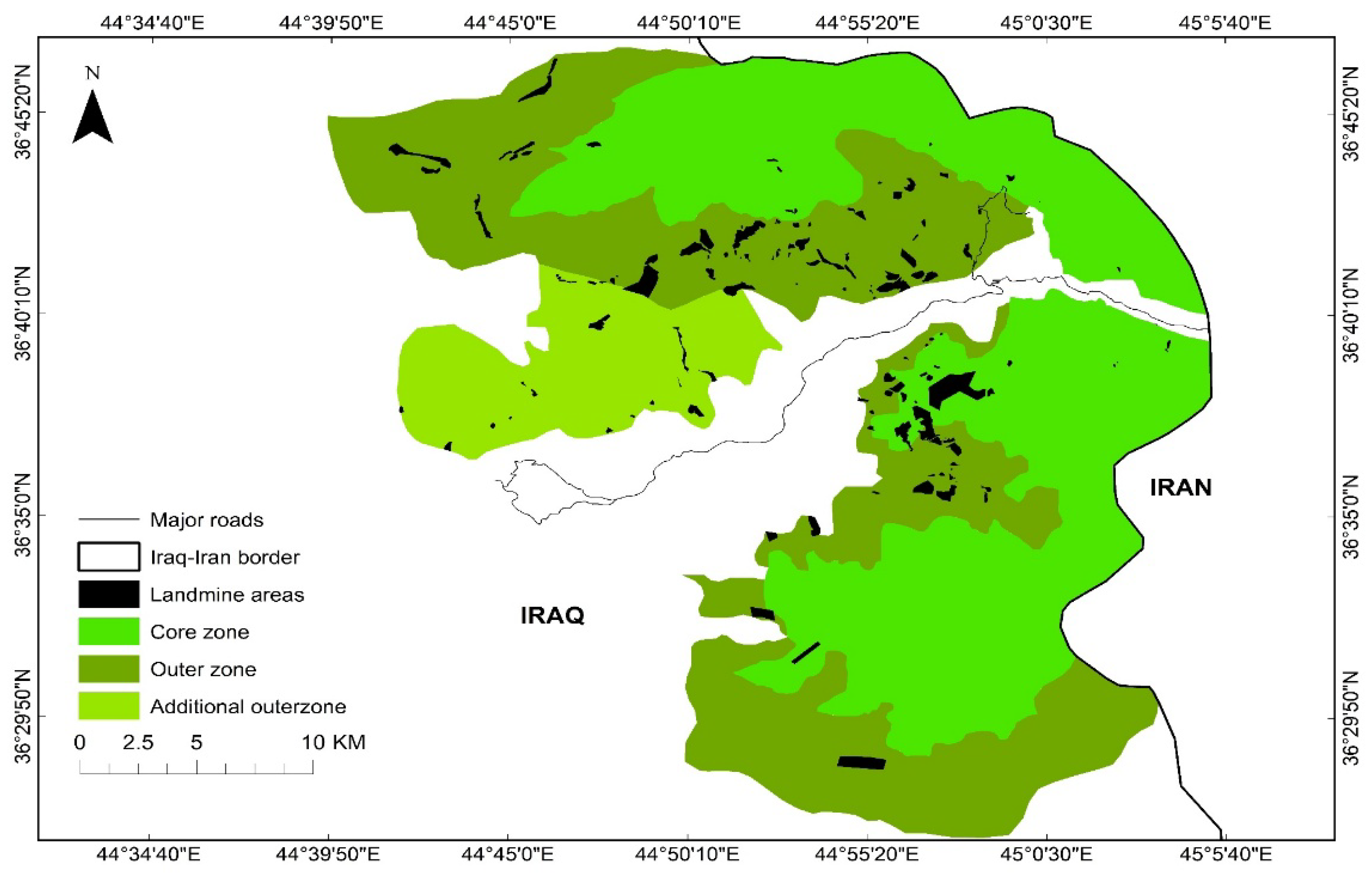
4.1. Environmental Impact of Mine Action in Kurdistan

One case study has been surveyed for the whole Erbil Governorate by Shabila et al. [6], concerning the victims of explosives remnant of war in the Erbil governorate from July 1998 to July 2007. The surveying reported that 285 victims were admitted to the Emergency Hospital in Erbil Centre with injuries that resulted in limb amputation for almost 72%, with the majority being males. Iran has also reported a high pre-hospital mortality rate in the study area on the other side of the border or previous frontline [6]. At the worldwide level, studies had documented 5426 casualties caused by mines and explosive remnants of war in 2007, regardless of many sufferers who are still assumed to go unrecorded [1]. However, the vast majority of landmine victims in the area of interest are civilians, and almost half of those are children. Most victims of landmines live in rural areas and small settlements and are in weak physical condition [48]. The last survey made by IKMAA reported they have eliminated the impact of landmines in Iraqi Kurdistan. The total contamination area in Erbil, Duhok, and Sulaymaniyah governorates that was covered by mines in 2006 was around 77,600 ha, this amount of area has been reduced to less than 32,000 ha in 2016 [11].
Certainly, the clearance of landmines in the study area will enable the civilian population to farm their lands free from fear and danger.

4.2. Landmine Clearing Process

The demining process has been conducted in the smallest patch of minefields inside the HSCZ during our visiting on 16 November 2016. A number of anti-personnel mines, unexploded ordinances, and explosive remnants of war were found, removed, and destroyed in 1366 m2 of landmine fields. The finding mines that were placed in the digging holes and were ready to be detonated by de-miners at the site are displayed in supplementary figures (Figure S1). The explosion took place inside the digging area in order to detonate the content of mines and other unexploded ordinances, followed by backfilling of the hole.
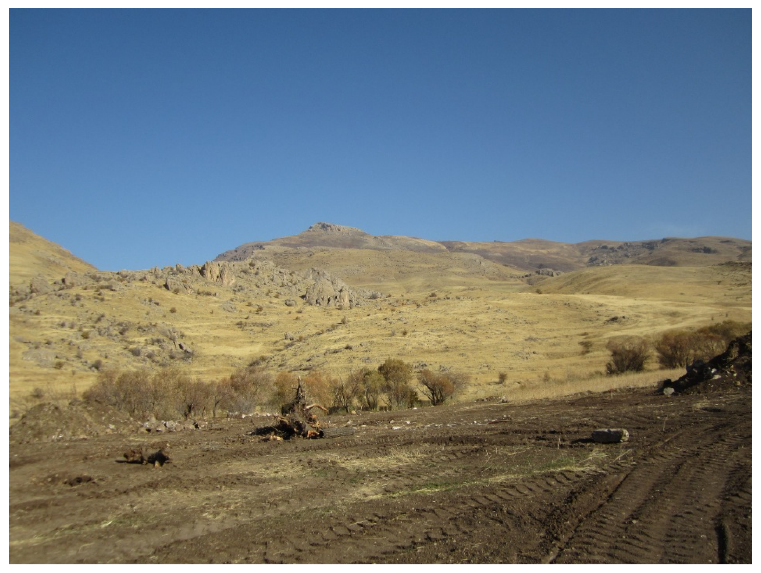
The act of moving soil laterally displayed in supplementary figures (Figure S2) during mine clearance operations leads to land degradation in the area, which causes the loss of soil structure, erosion, and compaction. This area will be exposed and eroded by water and wind, which results in loss of productive soil and nutrients. This may bring problems during wet and rainy winters that may lead to increased flooding. Additionally, compacted soil induced by heavy equipment (excavator) can also be observed during clearing operations. Furthermore, human activities during mine clearance have led to degradation of land resources, which are the basis for sustainable food security and could also lead to a reduction in yields.
In our study, two categories of human induced degradation processes can be recognised: soil degradation by displacement of soil material by heavy equipment during the mine clearance operation, and soil compaction by heavy equipment. These increase the runoff during rainy seasons in the study area and reduce the pore size and change the physical soil environment. During the demining and mine clearance operations the vegetation and topsoil will be removed, which leads to damage of the natural environment and impedes the sustainability of socio-economic expansion.
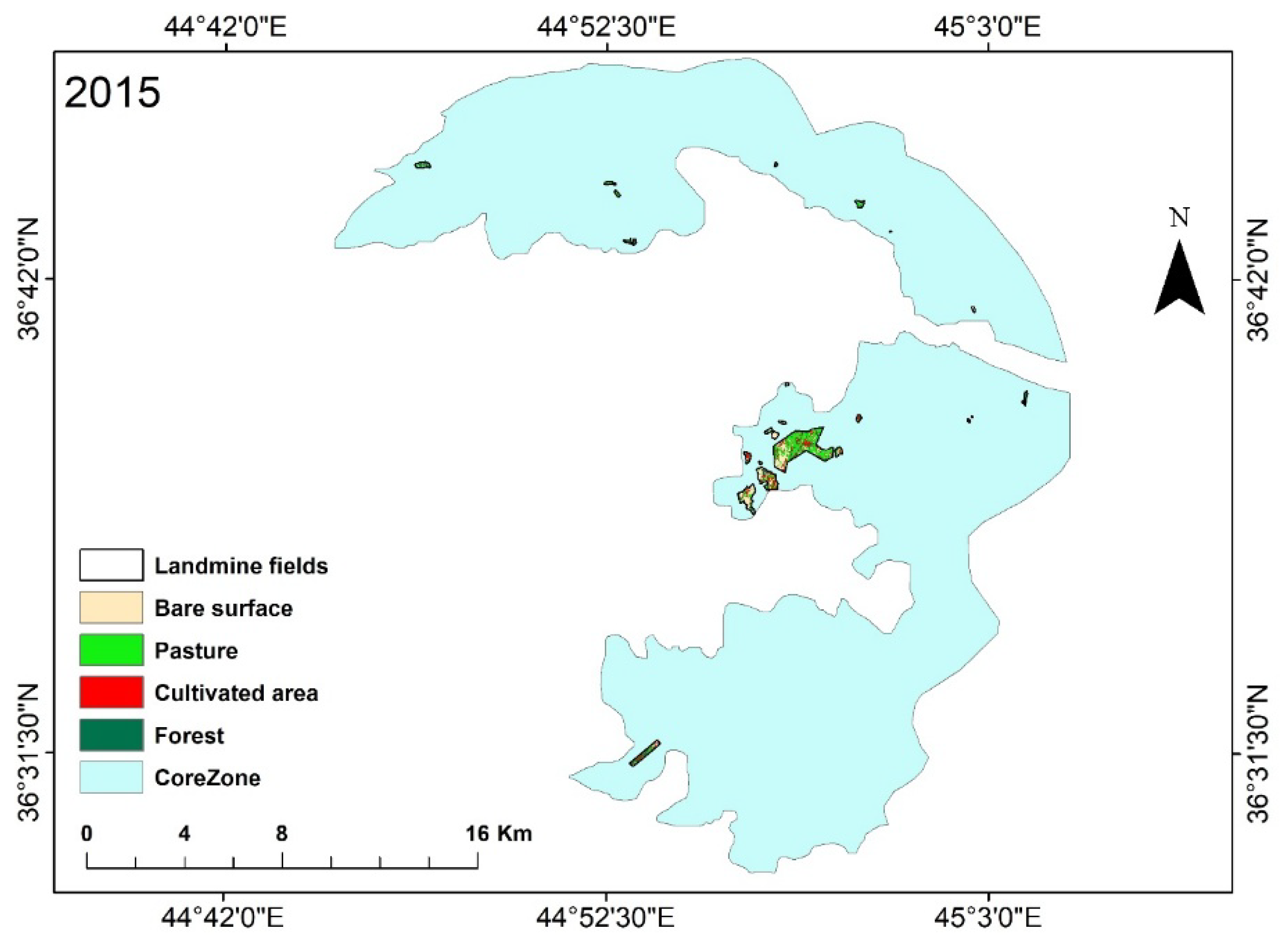
Furthermore, soil productivity in the restricted landmine areas dramatically decreased as the land was contaminated during the explosions, the fertile top soil was removed, and root systems are likely to have been disrupted. Therefore, the consequences of landmine clearance processes in restricted landmine areas that cover around 420.47 ha in HSCZ could take the form of various types of land cover changes, transforming the landscape, changing soil composition, and reducing soil fertility. The total volume of de-surfaced (removed) and the amount of removed and disturbed top soil by excavator inside the restricted areas is around 0.00084 km3 (4.20 km2 × 0.0002 km) (Table 7).
In other words, 840,000 m3 of top soil has been displaced, although fertile top soil has been lost when scraped by excavator, thus soil erosion reduces its productivity primarily through the loss of plant available water capacity [53]. Consequently, since there was no agricultural activity in the mine-suspected and cleansed areas, arable land has been substantially reduced (Table 4).

4.3. Environmental Impact of Clearing Landmines by Heavy Equipment

Heavy equipment during mine clearance operations can create visible patterns of soil disturbance. Following the clearance operation, the cleared area can be exploited as arable land for planting crops and trees, then would be subjected to the most disturbed soil in the mosaic of soil conditions. Figure 5 displays the impact of mine clearance on the physical and economic environment. It shows the destruction of the soil structure and vegetation as well as soil compaction as a result of operating heavy equipment that leads to reducing the infiltration rate into the soil [43]. Thus, the clearing process will accelerate soil erosion, cause soil loss on site, and affect productivity through inducing reduction in crop yields [54,55]. Further, “the compaction influences the exchange of oxygen and carbon dioxide between the root zone of plants and the atmosphere” [13].
A major environmental concern appears during the landmine clearance in the study area through the washing away by rainwater or blowing by air of the topsoil layer. However, through the heavy equipment (shovel) destroying the topsoil and through the clearance process, the following types of land degradation can occur: loss of vegetation cover, loss of soil fertility, soil structure change, and soil erosion. Moreover, land degradation is one of the main problems affecting the ecological balance of the landscape. Furthermore, soil productivity will be reduced as fertile topsoil could be lost because of the removal of the topsoil by means of scraping by heavy machineries when clearing the landmines in the Halgurd-Sakran Core Zone [53].
The effects of heavy equipment on the physical soil properties are documented well. Many scientists have addressed the compaction of soil by heavy machinery and their impacts. For instance, Krmenec [56] made a comparison for corn yields in compacted and non-compacted soils. The yields of corn were higher in un-trafficked soil than heavily-trafficked row soil. He also noted that the ears of corn were smaller than the ears from the non-compacted plots [28,56]. Soil compaction leads to changes in the amounts and balances of growth hormones in plants, especially increases in abscisic acid and ethylene, reported Kozlowski [57]. However, DeJong-Hughes [28] observed that the compaction in dry soil differs from wet soil, although yields under compacted wet weather would be lost as a result of increased risk of root diseases and increasing denitrification induced by decreased soil aeration. Mines can severely impede the production of food crops such as in cases where the fertile top soil is removed during the mine clearance operations of the restricted minefield land. In HSCZ the top soil in around 420.47 ha has been scraped, eventually leading to soil erosion and possible desertification, leaving an open, exposed landscape accentuated by the high drainage system of HSCZ geomorphology. This man-made damage to soil stability, though justified by the population safety constraints, would have irreversible effects, taking into consideration that this ancient soil is developed through a very slow geochemical alteration of the metamorphic-igneous and sedimentary rocks that make the bedrock of the soil. Thus, soil with less cultivated areas and plants become vulnerable, drier, and more susceptible to erosion by wind and rain. Additionally, the operations transform the landscape (Supplementary Materials, Figures S1 and S2).
During the mine clearance operations in Halgurd-Sakran National Park (HSNP) two processes can be observed: the removal (displacement) of surface soil and soil compaction. Thus, these influence soil properties physically, chemically, and biologically. Therefore, the abovementioned studies are relevant to the current study, where these areas could be used for agricultural purposes in HSNP.

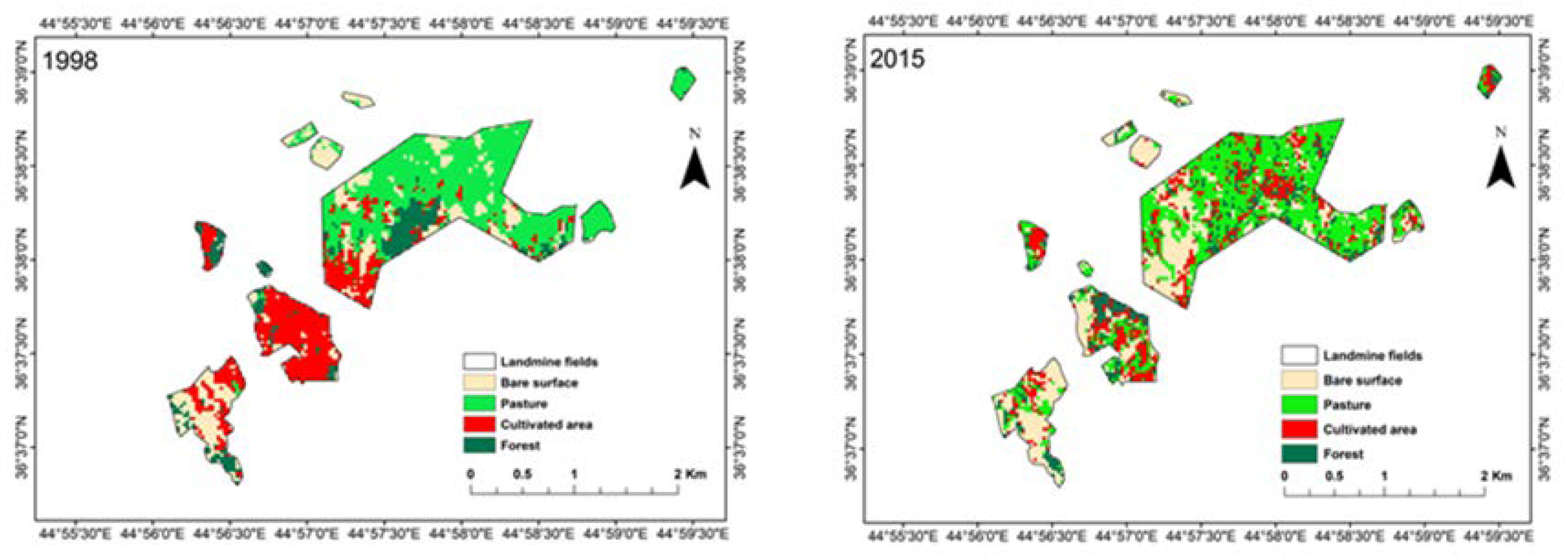
4.4. Analysis of Cultivated Area Loss and Socio-Economic Indicators

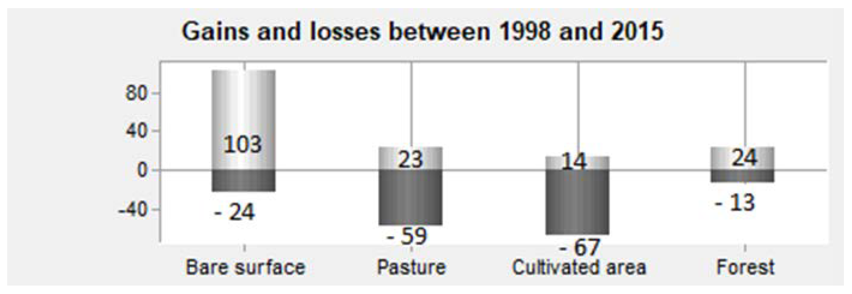
The Number of Patches (NP) decreased across all LULC classes, except pasture land. However, a decreasing NP means less fragmentation in the restricted areas. Thus, the bare surface, cultivated areas, and forest classes were less affected by fragmentation in the period from 1998 to 2015.
The overall land transformation has been observed for all classes over the last 17 years in this area. In fact, the role of existing organisations in the study area raised the awareness level, but the agricultural production activities declined sharply in areas that were covered by mines.
Furthermore, the total amount of human land use in landmine areas was relatively small in 2015 compared with 1998. The reason is that, after the major historical event in 2003, the international humanitarian organisations and non-governmental organisations (NGOs) opened the way and ran programs for development work in Iraq and the Kurdistan region. Besides, poverty in Iraq and the Kurdistan Region reduced after 2003.
Since 1991, NGOs of European countries have played an important role in rebuilding houses which were completely destroyed by the previous Iraqi regime [10]. When rural people returned to their places after 1991’s events (the First Gulf War), they found their fertile land and farms replaced by landmine fields [58]. Subsequently, very few people understood the importance of mine awareness education (MAE) and therefore they fell victims to such explosive devices. Increasing awareness material through sessions and workshops by organisations, especially by the Iraqi Kurdistan Mine Agency Action (IKMAA), made people more aware about the risks of landmines and other explosive ordnances. Thus, the casualties that caused by landmines have been reduced.
This awareness lead the farmers to lose their lands and jobs as they were unable to tend to their crops, as these areas were deployed with landmines and became even more undesirable. Landmines slowed down progress in HSCZ, otherwise agricultural production and productivity could have doubled. Table 4 illustrates how the cultivated lands reduced before and after raising the awareness before and after 2003. Therefore, reducing the cultivated areas can be linked to the rising mine awareness education in order to reduce deaths and injuries from landmines and unexploded ordnance through information and education. Gebrehiwot and Kara [3] discussed how the presence of mines in agricultural land hinders agricultural productivity. Further, a reduction in pasture land between 1998 and 2015 can be mainly attributed to the gain from bare surface. On the other hand, the trend for bare surface and forestland of the entire restricted landmine area is towards more aggregate holdings in the HSCZ. Increased forestland can be related to the socio-economic boom and stopping illegal logging for fuel wood. Islam and Sato [59] stated that illegal logging and conversion of forest land were the ultimate causes of forest deforestation in Bangladesh.
The role of “rural–urban” and “urban–rural” migration can have linkage with this rapid change. Moreover, the re-migrants in HSCZ after 2003 learnt new skills and came back with a better economy, better life experiences, and brought back much needed human capital. For instance, the lower the level of education of the migrant, the greater importance the push factors have, argued Sridhar et al. [41] during their primary survey of migrants in Bangalore, India.
It is worthy to mention that there was a forced migration, which was a political factor that compelled people to leave their places and migrate to another place (cities, districts, and sub-districts) during the 1980s. During their stay in the urban areas they enjoyed the same public services, performed job creation, and promoted public welfare with a better economy when they returned after the first Gulf War and particularly after the Fall of Baghdad in 2003 or after lifting the sanctions on Iraq [47].
The degradation of ecosystems has several impacts and dimensions on rural livelihoods and management of natural resources. Researchers addressed the impact of degraded lands on sustainable natural resources. For instance, Lubowski et al. [60] found that less intensive agricultural uses of cultivated croplands are less productive and more vulnerable to erosion than other intensified cultivated lands. This phenomenon can be observed in HSNP as land degradation and loss of biodiversity could have put the park’s ecosystems under intense pressure.

5. Conclusions

Socio-economic status and anthropogenic activities (mechanical mine-clearing devices) in restricted areas play a significant role in the park. Pasture and cultivated areas have continued to shrink due to mine clearance operations from 1998 to 2015 inside restricted areas. Moreover, anthropogenic activities have been examined in this study through degradation processes in restricted landmine fields in the Halgurd-Sakran Core Zone. These activities exposed the soil and accentuated natural erosional processes such as wind and rain during the mechanical clearance, which leads to soil loss and accelerate soil erosion in restricted landmine fields. Changes in land reduce the potential of the productivity. Therefore, the IKMAA should consider the possible negative impacts during their processes to ensure they do no further harm to the environment, as the aforementioned consideration is becoming highly significant during mine clearance.
This work is intended as a broad overview of the mine clearance operations and environmental conditions in the aftermath of subsequent conflicts in the proposed protected area. To conclude, the risk of site degradation and soil disturbance exists whenever heavy equipment is used in mine clearance operations.

Supplementary Materials

The following are available online at https://www.mdpi.com/2071-1050/10/7/2422/s1. Figure S1: photograph showing anti-personnel mines and unexploded remnant ordinance collect in explosion pits for eventual controlled detonation in HSCZ, and Figure S2: showing clearing process by excavator of a minefield in the HSCZ, which removed top soil (20 cm) are being scraped away.

Author Contributions

All authors contributed to the conception of the study. R.H. collected the input data; carried out, conceived, and designed the methodology; analyzed the data; and wrote the paper. H.B. and K.K. supervised the research and contributed to the manuscript.

Acknowledgments

Financial support for this study was provided by Soran University. This work forms a part of a study and is supported by the Soran Research Centre (SRC), Soran University and the Centre for Landscape and Climate Research (CLCR), University of Leicester. H. Balzter was supported by the Royal Society Wolfson Research Merit Award, 2011/R3, and the NERC National Centre for Earth Observation in the UK.

Conflicts of Interest

The authors declare no conflict of interest.

References

  1. LeBrun, E.; Damman, S. Addressing Explosive Ordnance in Peace Processes; Centre for Humanitarian Dialogue: Geneva, Switzerland, 2009. [Google Scholar]
  2. Chitraker, P.S. Mine-risk education in nepal. J. Conv. Weapons Destr. 2009, 13, 10. [Google Scholar]
  3. Gebrehiwot, E.; Kara, H. Economics of Landmines and Demining; Naval Postgraduate School Monterey: Monterey, CA, USA, 2009. [Google Scholar]
  4. Bier, G.L. The economic impact of landmines on developing countries. Int. J. Soc. Econ. 2003, 30, 651–662. [Google Scholar] [CrossRef]
  5. Šiljeg, A.; Šiljeg, S.; Šiljković, Ž. Conditions and development tendencies of touristic offer in kupres municipality (bosnia and herzegovina). Geoadria 2010, 15, 305–325. [Google Scholar] [CrossRef]
  6. Shabila, N.P.; Taha, H.I.; Al-Hadithi, T.S. Landmine injuries at the emergency management center in erbil, iraq. Confl. Health 2010, 4, 15. [Google Scholar] [CrossRef] [PubMed]
  7. 10 Countries With The Most Landmines. Available online: http://listverse.com/2008/08/11/10-countries-with-the-most-landmines/ (accessed on 11 July 2018).
  8. Sharnetzka, C.S. The oslo land mine treaty and an analysis of the united states decision not to sign. Dick. J. Int’l L. 1997, 16, 661. [Google Scholar]
  9. Chitraker, P.S. Economic reintegration and rehabilitation of nepalese landmine/ied victims. J. Conv. Weapons Destr. 2010, 14, 18. [Google Scholar]
  10. Brenneman, R.L. As Strong as the Mountains: A Kurdish Cultural Journey; Waveland Press: Long Grove, IL, USA, 2016. [Google Scholar]
  11. Hussein, J.J. Kurdistan’s erbil mine action center. J. Conv.Weapons Destr. 2015, 18, 11. [Google Scholar]
  12. Gangwar, A. Impact of War and Landmines on Environment. Available online: https://pdfs.semanticscholar.org/8277/4aeae44b32534d5ed24aded641432da1b4f2.pdf (accessed on 11 July 2018).
  13. Berhe, A.A. The contribution of landmines to land degradation. Land Degrad. Dev. 2007, 18, 1–15. [Google Scholar] [CrossRef]
  14. UNICEF. International Guidelines for Landmine and Unexploded Ordnance Awareness Education; UNICEF: New York, NY, USA, 1988. [Google Scholar]
  15. Bilukha, O.O.; Laurenge, H.; Danee, L.; Subedi, K.P.; Becknell, K. Injuries and deaths due to victim-activated improvised explosive devices, landmines and other explosive remnants of war in nepal. Inj. Prev. 2011, 17, 326–331. [Google Scholar] [CrossRef] [PubMed]
  16. Yadav, S.K. The Causes and Consequences of Activation by Non Clearance of Explosive Remnants in Aftermath of a Decade Long Insurgency of Maoist on Children: (Nepalese Perspective). Available online: https://s3.amazonaws.com/academia.edu.documents/31038626/Explosive_Remnants_of_War.pdf?AWSAccessKeyId=AKIAIWOWYYGZ2Y53UL3A&Expires=1531291011&Signature=PLeW4nL7pXa9%2BN5kzEwIUw81oLw%3D&response-content-disposition=inline%3B%20filename%3DThe_Causes_and_Consequences_of_Activatio.pdf (accessed on 11 July 2018).
  17. Davies, G.M. Living with Landmines: Mine Action, Development and Wellbeing in Post-Conflict Societies–A Case Study in Cambodia. Ph.D. Thesis, University of Bath, Bath, UK, 2015. [Google Scholar]
  18. Fraser, M. Landmines: An ongoing environmental health problem for the children of afghanistan. J. Rural Remote Environ. Health 2003, 2, 76–89. [Google Scholar]
  19. Douglas, I. The local drivers of land degradation in south-east asia. Geogr. Res. 2006, 44, 123–134. [Google Scholar] [CrossRef]
  20. Salvati, L.; Bajocco, S. Land sensitivity to desertification across italy: Past, present, and future. Appl. Geogr. 2011, 31, 223–231. [Google Scholar] [CrossRef]
  21. Bajocco, S.; De Angelis, A.; Perini, L.; Ferrara, A.; Salvati, L. The impact of land use/land cover changes on land degradation dynamics: A mediterranean case study. Environ. Manag. 2012, 49, 980–989. [Google Scholar] [CrossRef] [PubMed]
  22. Saikia, A.; Hazarika, R.; Sahariah, D. Land-use/land-cover change and fragmentation in the nameri tiger reserve, india. Geogr. Tidsskr.-Dan. J. Geograph. 2013, 113, 1–10. [Google Scholar] [CrossRef]
  23. Fasona, M.; Omojola, A.; Onyeahialam, A. Mapping land degradation and forest resource loss from fused landsat tm and nigeriasat-1 images in some parts of the southwest coast of nigeria. IAHS Publ. 2007, 316, 110. [Google Scholar]
  24. Gardner, C.M.; Laryea, K.B.; Unger, P.W. Soil Physical Constraints to Plant Growth and Crop Production; Land and Water Development Division, Food and Agriculture Organization: Rome, Italy, 1999. [Google Scholar]
  25. Wolkowski, R.; Lowery, B. Soil Compaction: Causes, Concerns and Cures; Division of Cooperative Extension of the University of Wisconsin-Extension: Madison, WI, USA, 2008. [Google Scholar]
  26. McKenzie, R. Agricultural Soil Compaction: Causes and Management. Available online: http://www1.agric.gov.ab.ca/$department/deptdocs.nsf/all/agdex13331 (accessed on 11 July 2018).
  27. Görlach, B.; Landgrebe-Trinkunaite, R.; Interwies, E.; Bouzit, M.; Darmendrail, D.; Rinaudo, J.-D. Assessing the economic impacts of soil degradation. In Volume IV: Executive Summary. Study Commissioned by the European Commission, DG Environment, Berlin; European Commission, DG Environment: Berlin, Germany, 2004. [Google Scholar]
  28. DeJong-Hughes, J. Tires, Traction and Compaction; University of Minnesota Extension: St Paul, MN, USA, 2009. [Google Scholar]
  29. Kertész, Á. The global problem of land degradation and desertification. Hung. Geogr. Bull. 2009, 58, 19–31. [Google Scholar]
  30. Happ, M. Impacts of Land-Cover Change and High Rainfall on Soil Erosion among Three Farms in Cerro Punta, Chiriquí, Panamá. Available online: http://digitalcollections.sit.edu/cgi/viewcontent.cgi?article=3025&context=isp_collection (accessed on 10 July 2018).
  31. Liang, Y.; Lal, R.; Guo, S.; Liu, R.; Hu, Y. Impacts of simulated erosion and soil amendments on greenhouse gas fluxes and maize yield in miamian soil of central ohio. Sci. Rep. 2018, 8, 520. [Google Scholar] [CrossRef] [PubMed]
  32. Thomas, D.S.; Goudie, A.S. The Dictionary of Physical Geography; John Wiley & Sons: Hoboken, NJ, USA, 2009. [Google Scholar]
  33. Armstrong, W.; Cousins, D.; Armstrong, J.; Turner, D.; Beckett, P. Oxygen distribution in wetland plant roots and permeability barriers to gas-exchange with the rhizosphere: A microelectrode and modelling study with phragmites australis. Ann. Bot. 2000, 86, 687–703. [Google Scholar] [CrossRef]
  34. Hofmann, U.; Rapillard, P. Post-Conflict Mine Action: Environment and Law; Oxford University Press: Oxford, UK, 2017. [Google Scholar]
  35. Hoffman, U.; Rapillard, P. Do no harm in mine action: Why the environment matters. J. Conv. Weapons Destr. 2015, 19, 13. [Google Scholar]
  36. Jahan, M. Impact of rural urban migration on physical and social environment: The case of dhaka city. Int. J. Dev. Sustain. 2012, 1, 186–194. [Google Scholar]
  37. Lewis, W. Economic Development with Unlimited Supplies of Labor; The Manchester School of Economic and Social Studies 22, 139–191, Reprinted in The Economics of Underdevelop-Ment; Agarwala, A.N., Singh, S.P., Eds.; Oxford University Press: Bombay, India, 1958. [Google Scholar]
  38. Smit, W. The rural linkages of urban households in durban, south africa. Environ. Urban. 1998, 10, 77–88. [Google Scholar] [CrossRef]
  39. Andersson, M.; Johansson, I. Rural-Urban Migration in Southwestern Rural Uganda-the Perceptions and Strategies of the Left-behind. Bacherlor’s Thesis, University in Gothenburg, Gothenburg, Sweden, 2013. [Google Scholar]
  40. Melesse, B.; Nachimuthu, K. A review on causes and consequences of rural-urban migration in ethiopia. Int. J. Sci. Res. Publ. 2017, 7, 2250–3153. [Google Scholar]
  41. Sridhar, K.S.; Reddy, A.V.; Srinath, P. Is it push or pull? Recent evidence from migration in india. South Asia Netw. Econ. Res. Inst. 2010, 10, 1–17. [Google Scholar]
  42. Satterthwaite, D.; McGranahan, G.; Tacoli, C. Urbanization and its implications for food and farming. Philos. Trans. R. Soc. B Biol. Sci. 2010, 365, 2809–2820. [Google Scholar] [CrossRef] [PubMed] [Green Version]
  43. Misak, R.; Omar, S. Environmental damages from minefields. J. Conv. Weapons Destr. 2007, 11, 15. [Google Scholar]
  44. Hamza, M.; Anderson, W. Soil compaction in cropping systems: A review of the nature, causes and possible solutions. Soil Tillage Res. 2005, 82, 121–145. [Google Scholar] [CrossRef]
  45. Patnaik, B.; Satpathy, I.; Mohanty, J.; Mandal, M.A. Determinants of migration from rural to urban india by the labourer-an overview. Blue Ocean Res. J. 2012, 4, 33–38. [Google Scholar]
  46. Jedwab, R.; Christiaensen, L.; Gindelsky, M. Demography, Urbanization and Development: Rural Push, Urban pull and … Urban Push? Policy Research Working Paper No. 7333; The World Bank: Washington, DC, USA, 2015. [Google Scholar]
  47. Thet, K.K. Pull and Push Factors of Migration: A Case Study in the Urban Area of Monywa Township, Myanmar. Available online: http://www.worldofstatistics.org/files/2014/03/Pull-and-Push-Factors-of-Migration-Thet.pdf (accessed on 11 July 2018).
  48. Hamad, R.; Balzter, H.; Kolo, K. Multi-Criteria assessment of land cover dynamic changes in Halgurd Sakran national park (HSNP), Kurdistan Region of Iraq, using remote sensing and GIS. Land 2017, 6, 18. [Google Scholar] [CrossRef]
  49. KRSO. Ministry of Planning 2016. Kurdistan Regional Statistics Office-KRSO. Available online: http//www.mop.gov.krd (accessed on 25 January 2017).
  50. Hamad, R.; Kolo, K.; Balzter, H. Post-War Land Cover Changes and Fragmentation in Halgurd Sakran National Park (HSNP), Kurdistan Region of Iraq. Land 2018, 7, 38. [Google Scholar] [CrossRef]
  51. McGarigal, K.; Marks, B.J. FRAGSTATS: Spatial Pattern Analysis Program for Quantifying Landscape Structure; U.S. Department of Agriculture, Forest Service, Pacific Northwest Research Station: Portland, OR, USA, 1995.
  52. McGarigal, K.; Cushman, S.A.; Neel, M.C.; Ene, E. FRAGSTATS: Spatial Pattern Analysis Program for Categorical Maps. Available online: www.umass.edu/landeco/research/fragstats/fragstats.html (accessed on 11 July 2018).
  53. Obalum, S.E.; Buri, M.M.; Nwite, J.C.; Watanabe, Y.; Igwe, C.A.; Wakatsuki, T. Soil degradation-induced decline in productivity of sub-saharan african soils: The prospects of looking downwards the lowlands with the sawah ecotechnology. Appl. Environ. Soil Sci. 2012, 2012. [Google Scholar] [CrossRef]
  54. Syahli, F. The Impact of Land use Change on Soil Erosion in Serayu Watershed; University of Twente Faculty of Geo-Information and Earth Observation (ITC): Enschede, The Netherlands, 2015. [Google Scholar]
  55. Lal, R.; Moldenhauer, W.C. Effects of soil erosion on crop productivity. Crit. Rev. Plant Sci. 1987, 5, 303–367. [Google Scholar] [CrossRef]
  56. Krmenec, A.J. Vehicle Traffic and Soil Compaction. Available online: https://www.researchgate.net/profile/Andrew_Krmenec/publication/282861214_Vehicle_Traffic_and_Soil_Compaction/links/561fda9008aea35f267e104d/Vehicle-Traffic-and-Soil-Compaction.pdf (accessed on 11 July 2018).
  57. Kozlowski, T. Soil compaction and growth of woody plants. Scand. J. For. Res. 1999, 14, 596–619. [Google Scholar] [CrossRef]
  58. McDowall, D. Modern History of the Kurds; IB Tauris: New York, NY, USA, 2003. [Google Scholar]
  59. Islam, K.; Sato, N. Deforestation, land conversion and illegal logging in bangladesh: The case of the sal (shorea robusta) forests. iForest-Biogeosci. For. 2012, 5, 171. [Google Scholar] [CrossRef]
  60. Lubowski, R.N.; Bucholtz, S.; Claassen, R.; Roberts, M.J.; Cooper, J.C.; Gueorguieva, A.; Johansson, R. Environmental effects of agricultural land-use change. Econ. Res. Rep. 2006, 25, 1–75. [Google Scholar]
Figure 1. Location map of the Halgurd-Sakran Core Zone (HSCZ) with its three zones (core, outer, and additional outer) and landmine fields in the Kurdistan Region of Iraq.
Sustainability 10 02422 g001
Figure 2. Land cover classification of minefields in HSCZ from a Random Forest classifier using Landsat data for the years 2015.
Sustainability 10 02422 g002
Figure 3. Land cover classification inside a part of restricted minefield in HSCZ from a Random Forest classifier using Landsat data for the years 1998 and 2015.
Sustainability 10 02422 g003
Figure 4. Gains and losses in hectares of LULC by category in different time periods (1998–2015). Dark and light colours are indications of gain and loss respectively.
Sustainability 10 02422 g004
Figure 5. Landmine field in HSCZ during the clearing process, (photo by R. Hamad 2016).
Sustainability 10 02422 g005
Table 1. Rural population for villages around Choman district [49].
Rural Rate201020112012201320142015
Choman villages12.00812.34812.68913.03713.38913.746
Table 2. Satellite (sub-scene) images used in this study to quantify landscape patterns and land cover change.
Satellite SensorPath/RowAcquisition DateResolutionBand Nos.
Landsat 7 ETM+169/03513 September 199830 m1, 2, 3, 4, 5, 7
Landsat 8 OLI169/03524 August 201530 m2, 3, 4, 5, 6, 7
Table 3. Metrics selected at class level for the quantification of landscape patterns in HSCZ.
MetricsUnitsDescription
PLAND%Proportion of the landscape occupied by certain LULC class [51]
NPnNumber of patches per class [51]
AREA_MNhaMean area of patches of the same LULC class [52]
Table 4. Trends of land us/land cover (LULC) class frequencies of the entire restricted minefields for years 1998 and 2015 in HSCZ.
LULC Classes1998%2015%Changes%Trend
Bare surface19.8439.08+19.24
Pasture40.0731.24−8.83
Cultivated27.6614.74−12.02
Forest12.4014.92+2.52
Table 5. Summary of the LULC conversions for all classes of restricted landmine fields in HSCZ between 1998 and 2015.
2015
1998Bare SurfacePastureCultivated AreaForest
Bare surface0.60090.07120.10240.2255
Pasture0.40610.54920.01510.0295
Cultivated area0.43390.15560.35260.0579
Forest0.12190.07960.16920.6294
Table 6. Values of patch number and mean patch size at the class level for the restricted landmine fields for years 1998 and 2015 in HSCZ.
LULCNP-1998NP-2015HeadingMPS-1998MPS-2015Heading
Bare surface102770.82.68
Pasture42493.92.14
Cultivated area75601.151.43
Forest53510.91.23
Table 7. The total volume of removed top soil for each restricted area in HSCZ.
FIDArea (km2)Volume (km3) of De-Surfaced Top Soil (Area km2 × Depth 0.0002 km)FIDArea (km2)Volume (km3) of De-Surfaced Top Soil (Area km2 × Depth 0.0002 km)
10.0250.000005140.0250.000005
20.1360.000002150.4330.000086
30.0440.000008160.0100.000002
40.0830.000016170.0010.000003
50.0640.000012180.5040.000100
60.0440.000008190.0140.000002
70.0130.000002200.0330.000006
80.0380.000007210.0320.000006
92.1760.000434220.1180.000023
100.0030.0000006230.2920.000058
110.0440.000008240.0800.000016
120.0720.000014250.0110.000002
130.0200.000004Total volume = 0.00084 km3

