Communication

Impact of the Wildlife Management Units Policy on the Conservation of Species and Ecosystems of Southeastern Mexico

by
Carolina Álvarez-Peredo
1,*,
Armando Contreras-Hernández
1,
Sonia Gallina-Tessaro
2,
Mariana Pineda-Vázquez
3,
Alejandro Ortega-Argueta
3,
Carlos Tejeda-Cruz
4 and
Rosario Landgrave
5
1
Red de Ambiente y Sustentabilidad, Instituto de Ecología A.C., Carretera Antigua a Coatepec 351, El Haya, Xalapa 91070, Veracruz, Mexico
2
Red de Biología y Conservación de Vertebrados, Instituto de Ecología A. C., Carretera Antigua a Coatepec 351, El Haya, Xalapa 91070, Veracruz, México
3
Departamento de Conservación de la Biodiversidad, El Colegio de la Frontera Sur, Unidad San Cristóbal. Carret. Panamericana y Periférico sur s/n, Barrio de María Auxiliadora, San Cristóbal de las Casas 29290, Chiapas, Mexico
4
Facultad de Medicina Veterinaria y Zootecnia, Universidad Autónoma de Chiapas, Carretera Terán—Emiliano Zapata Km. 8, Tuxtla Gutiérrez 29050, Chiapas, Mexico
5
Red de Ecología Funcional, Instituto de Ecología A. C., Carretera Antigua a Coatepec 351, El Haya, Xalapa 91070, Veracruz, México
*
Author to whom correspondence should be addressed.
Sustainability 2018, 10(12), 4415; https://doi.org/10.3390/su10124415
Submission received: 14 September 2018 / Revised: 17 November 2018 / Accepted: 22 November 2018 / Published: 26 November 2018
(This article belongs to the Special Issue Sustainable Wildlife Ecology and Conservation)

Abstract

:
Wildlife in Latin America is subject to enormous pressures and, as in most countries, has been negatively impacted in Mexico. In 1997, the Mexican government implemented a policy of conservation and sustainable use of wildlife units (called UMAs, by their Spanish acronym) that comprises intensive and free-living management. Since then, no national or regional assessments have been conducted to estimate impacts and benefits even with 5529 registered UMAs now covering almost 20% of the national territory. The objective of this study was to characterize the SUMA (UMAs System) in a regional context in three states of southeastern Mexico. The impact of UMAs was studied in depth through a selection of representative case studies: three species of mangrove (Avicennia germinans, Laguncularia racemosa and Rhizophora mangle), ponytail palm (Beaucarnea recurvata), red cedar (Cedrela odorata) and white-tailed deer (Odocoileus virginianus), and a connectivity analysis, in order to evaluate the contribution of the UMAs to the conservation of species and ecosystems. The number of active UMAs at regional scale was 834, managing 273 species; 7.1% of the UMAs manage nationally-prioritized species, while 8.3% and 94.3% manage endemic and native species, respectively. Conservation of ecosystems has been successfully achieved through the UMAs that manage mangrove and white-tailed deer. We propose to promote the establishment of free-living UMAs that would contribute to increase the conservation areas. Finally, we highlight the relevance of regional-scale spatial analysis as an important tool for improving environmental policy and conservation strategies.

1. Introduction

Wildlife in Latin America is under enormous pressure as a result of human demographic growth, high rural marginalization and the lack of effective development and conservation policies where economic interests prevail over sustainability [1,2]. The strategy of wildlife conservation through sustainable use has been directed mostly towards indirect policy mechanisms. This type of initiative, known as “conservation by distraction” [3] acts to incentivize rural communities to conserve biodiversity by providing sources of income and alternative forms of production through sustainable resource use [4]. However, some authors [5,6] have indicated that these indirect models do not present optimal conditions due to technical, economic, social and political difficulties, particularly in rural communities.
In order to analyze wildlife management in Latin America, it is necessary to understand the cultural and socioeconomic context of the countries that form this region. Most of these countries have to exploit as much as possible the resources they have available in order to sustain their fragile economies and demand for consumption due to accelerated demographic growth [7]. In addition, the indigenous and most of the peasant communities depend on production for auto-consumption and subsistence hunting [8,9]. Wildlife represents an important, often the only, source of calories and proteins in the diet of those groups [10] although, they are also used for other traditional purposes, such as clothing, tools and pets, as well as for medicinal, ritual and religious purposes, among others [11].
Wildlife populations are threatened by deforestation, large-scale fragmentation and habitat loss [7]. Some species are more sensitive than others in the face of large-scale transformations of ecosystems. Moreover, due to their exploitable condition, resource species are subjected to additional pressures compared to species that are not directly used and thus commercial exploitation has a greater effect on biodiversity. These differential pressures to which species are subjected should be reflected in different management strategies. In this way, conservation policy may be oriented towards the protection of charismatic species that act as umbrella for protecting other species [12], sensitive species that act as indicators of ecosystem health, or focused on the sustainable use of species that provide ecosystem services.
In Latin America at present, different schemes and modalities of conservation of wildlife exist that reflect the economic, cultural, social and ecological heterogeneity of the territories [7]. Wildlife management implies human action over the administration of resources [9], particularly in legal and administrative terms (e.g., the Forestry law 1700 of Bolivia, the Pro-Extractive Forestry Policies of Brazil, the Wildlife Law in Mexico). A first challenge for governments is to achieve effective conservation of biodiversity that also helps to improve the quality of life of rural and marginalized people, reducing poverty and promoting self-management and sustainability [9,13,14]. A second challenge is to demonstrate the effectiveness and impacts of such government efforts through revision and evaluation of ongoing wildlife management policies.

1.1. Management and Use of Wildlife in Mexico

The natural and cultural history of Mexico has made it a key element in the conservation and management of a significant part of the global biodiversity [15]. The presence of native groups, numerous languages and traditional systems of knowledge (ethnic and cultural diversity) [16], together with its geographic location, great richness of ecosystems and species, climatic zones, and geomorphological characteristics, distinguish the country as a strategic and highly biodiverse territory.
However, the wildlife of Mexico has been negatively impacted by threats that include deforestation, unsuitable livestock management causing overgrazing and soil degradation, extensive agriculture, draining of wetlands, urban and industrial contamination, illegal exploitation of plants and animals and the introduction of exotic species [17,18]. Deforestation of tropical and temperate forests for agriculture and livestock production alone represents one of the greatest threats to wildlife [15]. This type of perturbation occurs most frequently in areas with high biodiversity that also happen to be the territories of different indigenous groups in Mexico, such as the central and southeastern states of the country: Oaxaca, Chiapas, Tabasco, Guerrero, Puebla and Veracruz [15]. These states are also marginalized regions that present extreme poverty.
In these regions in particular, resistance and the struggle for land property rights played a determinant role in the failure of the management and sustainable use of wildlife up to the mid-1990s [19,20]. This socioeconomic trend and the consequent negative impact on natural resources obliged the Mexican authorities to modify the legislation relating to wildlife in order to propose alternatives and new legal schemes addressing management and conservation [15].

1.2. Management Units for the Conservation and Sustainable Use of Wildlife (UMAs) in Mexico

In 1997, the Ministry of the Environment and Natural Resources (SEMARNAT) started implementing the Management Units for the Conservation and Sustainable Use of Wildlife (UMAs, by its Spanish acronym) as territorial units, in which the owners, whether governmental, private or under the ejido (in Mexico, the communal farmland of a village, usually assigned in small parcels to the villagers to be farmed under a federally supported system of communal land tenure) communal system, receive authorization to make sustainable use of certain wildlife species. There are two types of management in the UMAs; first are the free-living ones that comprises wildlife species in the wild, without movement restraints. These are big areas from hundreds to thousands of hectares. The second type comprises small properties with species maintained in captivity, called intensive UMAs. The main objectives of the UMAs are to integrate ecological, economic, social and legal strategies in order to address the biological issues, while simultaneously promoting participative conservation by involving the key stakeholders in decisions and actions of sustainable management [21]. Subsequently, in the year 2000, there were reforms to the legislation to permit and promote new economic incentives for the conservation of biodiversity. These reforms allowed the private, communal and ejido landowners, as well as representatives and administrators, to benefit directly from the use of the wildlife [22].
However, controversy exists regarding the functionality and effectiveness of this policy in terms of appropriate resource management for conservation, the limited economic impact of this scheme on the stakeholders involved [22,23] and on the development of the communities [6,23,24,25]. In the twenty-one years since the beginning of the UMAs as a pioneering scheme of biodiversity conservation—with 5529 UMAs registered, corresponding to almost 20% of the national territory (35 million ha) [26,27]—no national or regional assessments have been conducted to estimate their impacts and benefits [28].
From the point of view of wildlife conservation in particular, the results of the operation of UMAs have not been comprehensively documented [29]. In general, the SEMARNAT lacks sufficient data to accurately determine whether the species in question are being used sustainably [15,25]. Indeed, the economic benefit of exploitation of certain species of flora and fauna has already been granted, prioritizing this above the objectives of biodiversity conservation. Furthermore, previous studies have highlighted the lack of an evaluation that could indicate the conditions (temporal, spatial and administrative) under which the UMAs would constitute an effective strategy for the conservation of the species and their habitat [30].

1.3. UMAs in Southeast Mexico

Around 60% of the area of southeastern Mexico is communal or ejido land [31], in which approximately 35% of the population are routinely unable to meet their basic needs [32]. Unlike most of the UMAs that function in the north of Mexico (large areas of privately-owned land), wildlife management in the ejido lands of the southeast are within a context of marginalization, poverty and the cosmogony of the local and indigenous communities [6]. In this region, traditional uses and local consumption of species are frequently the result of subsistence hunting and other uses of the biodiversity that can represent economic income for the communities [22].
Establishment of UMAs in this region implies internal adjustments in the communities in terms of governance and social organization, which defines the use of and access to the natural resources, thus generating “conflicts of conservation” [33,34]. In these cases, the stakeholders involved often may have opposing perceptions and perspectives regarding the use and conservation of natural resources [33]. These conflicts generally result in a negative impact on the biodiversity (through overexploitation of species and destruction of habitat) and on the socioeconomic development of the local communities (as a consequence of the restriction of access to natural resources for traditional use and subsistence) [34].
However, establishment of indicators and an evaluation framework that would allow measurement of the effectiveness and sustainability of the UMAs, linked in turn to socioeconomic factors, biodiversity loss, human impact and economic benefits to the community, among others, is a subject that is still incipient in terms of methodological development [35]. According to Ortega-Argueta and collaborators [28], the development of such indicators is necessary in order to measure the long-term impact of the UMAs strategy, since the lack of multidimensional evaluation generates bias in the evaluation of its effectiveness as an instrument of in situ and ex situ wildlife conservation [36,37].
In this article, we present a study relating to this national wildlife policy (UMAs) that has been in operation for more than two decades in Mexico. The paucity of studies and information regarding the effectiveness of the UMAs in Mexico, both in terms of biodiversity conservation and the socioeconomic development of rural communities, prompted us to conduct this diagnostic. The objectives of the study were to: (1) characterize the UMAs System (SUMA, by its Spanish acronym), both in the intensive and free-living management, in the regional context in three states of southeastern Mexico (Chiapas, Tabasco and Veracruz); and (2) evaluate the impact of the UMAs on wildlife conservation through the selection of representative case studies of managed plant and animal species. Our goal in this paper is to present the main achievements and failures of this 21-year-old policy in the study area and to highlight its impacts on the southeastern region of the country.

2. Study Area and Methods
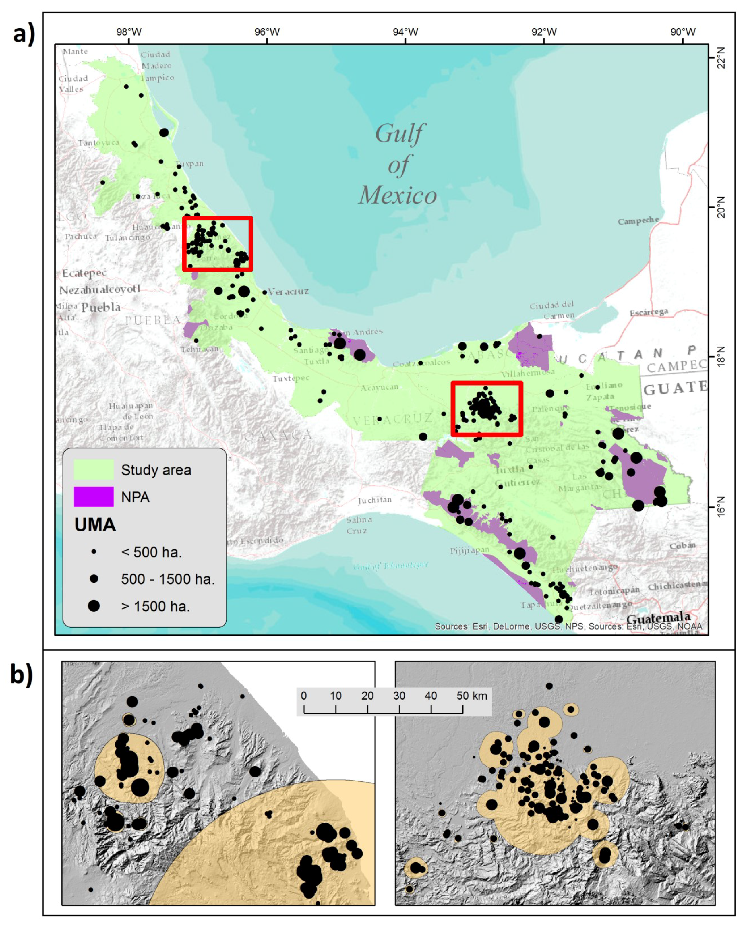
2.1. Study Area

The study area comprises three states of southeastern Mexico: Chiapas, Tabasco and Veracruz. The region covers an area of 170,468 km2 (8.6% of the national territory) and has 14 natural regions [38] and 347 municipalities [39], which are the smallest administrative unit. It is bordered by six states of the Mexican republic, and has an international frontier with Guatemala and coastline on the Gulf of Mexico and the Pacific Ocean of 936 and 255 km in length, respectively (Figure 1a).
The study region is one of the zones of greatest biological diversity in Mexico and Mesoamerica; the presence of ecosystems such as the tropical humid forest, tropical seasonally dry forest, temperate forest and montane cloud forest is responsible for the great taxonomic richness of the region. The distribution of flora and fauna in the three states that comprise the study area differs markedly from that of the rest of the country. The great biological diversity of the region includes various endemic and threatened species, according to Mexican legislation (Mexican Official Norm 059-SEMARNAT-2010) [40,41]. In the particular case of the vascular plants, of the 21,841 species registered in the national territory, the highest percentages of presence are found in two of these three states (35.9% in Chiapas with 7830 species and 31.5% in Veracruz with 6876 species), while Tabasco comprises only 12% with 2616 species [42].
The study area has a total human population of 15,725,685 (representing 13.2% of the national population). It is a multiethnic and pluricultural region, in which 18.6% (2,930,927 inhabitants) correspond to the indigenous population, belonging to 14 different indigenous groups: Jacalteco, Mame, Tojolabal, Chakchiquel, Motozintleco, Lacandón, Tzeltal, Zoque, Tsotsil, Chol and Chuj, Chontal, Totonaca, Náhuatl and Popoluca [43,44].

2.2. Methodology

2.2.1. Characterization of the SUMA at a Regional Scale

Information referring to the UMAs registered in the three states (both intensive and free-living management) was obtained from the official database of the General Direction of Wildlife (DGVS, by its Spanish acronym) of SEMARNAT at federal level, through a request made to the National Institute of Transparency, Access to Information and Protection of Personal Data (INAI, by its Spanish acronym) and the National System of Environmental Information and Natural Resources [45]. This information was contrasted with a review of official archives of the DGVS of SEMARNAT state delegations of Chiapas, Tabasco (updated in June 2017) and Veracruz (updated in February 2017). In addition, official databases of the Secretariat of the Environment (SEDEMA) in the state of Veracruz up to 2017 were utilized.
For characterization and analysis of the UMAs, only those that had presented their annual or semestrial report to SEMARNAT on dates after December 2012 were considered, or those that had presented some permit of wildlife use during the last six years (of the period 2011–2012 to 2016–2017). This was done in order to eliminate those UMAs that were not in continuous operation but still registered. The features analyzed were: geographic location, area of territory registered as an UMA, taxonomic classification of the species under management, origin of the species under management, category of risk or national and international protection of the species under management according to the Mexican legislation (NOM 059-SEMARNAT-2010, by its Spanish acronym) [40], the Red List of the International Union for Conservation of Nature (IUCN) [46] and the Convention on International Trade in Endangered Species of Wild Fauna and Flora (CITES) [47] and modalities of management: intensive vs. free-living (also known as “extensive”). These elements were analyzed quantitatively in frequency graphs for each of the states. It should be noted that inconsistencies were detected in the figures managed in the different official databases consulted, for which reason some of the values presented may have a certain degree of bias (over or underestimations).

2.2.2. Analysis Per Vegetation Type and Land Use

From the official database of SEMARNAT at the federal level, information was obtained regarding the spatial location (with geographic coordinates) of the UMAs registered for the three states. In addition, the polygons corresponding to each one of the UMAs were obtained in a vectorial projection using geographic information systems [48].
For characterization of the vegetation types and land uses, the Land Use and Vegetation Map SERIES V [49] was used. For this analysis, only the free-living UMAs were considered, assuming that this UMA type contributes a greater area of conserved ecosystems to the SUMA. Through the spatial projection of each polygon of UMA onto the Land Use and Vegetation Map, the area occupied by each of the nine previously established categorical groups of vegetation types: Rain Forest, Subhumid Forest, Temperate Forest, Xerophilic Shrub, Pastures, Grassland induced or cultivated, Other Hydrophilic vegetation, Halophilic and Gypsophilic vegetation and Other types of vegetation (Appendix A) was quantified. These groups of vegetation represent groupings of the original vegetation and land use categories reported in the official cartography mentioned above. These groupings include the arboreal, shrub and herbaceous vegetation included in the original cartography [45].

2.2.3. Spatial Analysis of the Optimum Factor of Potential Connectivity among the UMAs and Protected Areas for Conservation at Regional Level

From the official database of SEMARNAT at federal level, a map was generated using geographic information systems [48], in which it was possible to locate the polygons of each of the free-living UMAs registered in the three states of the study region. We used only free-living UMAs for this analysis based under the same criteria of the vegetation type analysis. From the vectorial projection, an optimum factor of potential connectivity among the UMAs was estimated. The connectivity factors tested were defined according to a multiplier of the area of each UMA (for example, factor five is equivalent to five times the area of the UMA, factor 20 is equivalent to 20 times the area of the UMA, etc.).
These connectivity factors were used to generate buffer zones of different sizes around the UMAs in order to represent the possible area of influence of each UMA according to its own area. The optimum factor of potential connectivity was selected by the following four criteria: (a) number of potential conservation areas; (b) maximum number of UMAs with overlapping buffer zones; (c) area (ha) of the UMAs with overlapping buffer zones; and (d) total area (ha) of the potential conservation areas, known as the potential area destined for conservation.

2.2.4. Evaluation of the Impact of the UMAs on Wildlife Conservation in Southeastern Mexico Through the Selection of Representative Case Studies

From the official information, four case studies from both intensive and free-living UMAs were selected based on the following criteria: (1) species registered in the greatest number of UMAs in the region; (2) species of ecological importance for habitat conservation; and (3) species that are threatened and of economic and commercial interest. Based on these criteria, the following case studies were selected: mangroves (Avicennia germinans, Laguncularia racemosa and Rhizophora mangle), red cedar (Cedrela odorata), ponytail palm (Beaucarnea recurvata) and white-tailed deer (Odocoileus virginianus). Biological, socioeconomic and management aspects were analyzed for each species and group of species. This detailed analysis fulfilled the conservation and development objectives of the UMA scheme while taking into account the various administrative models.

3. Results

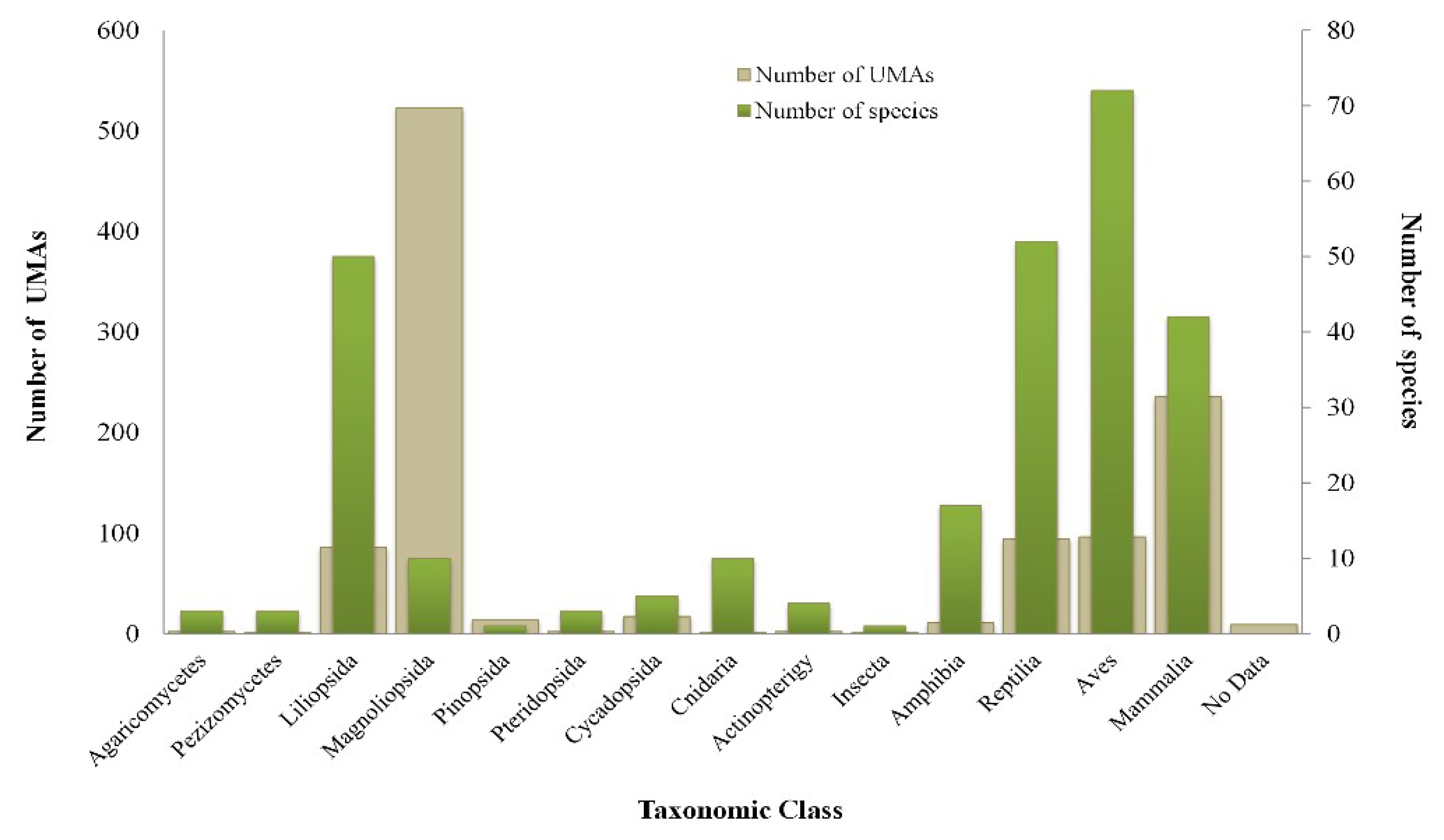
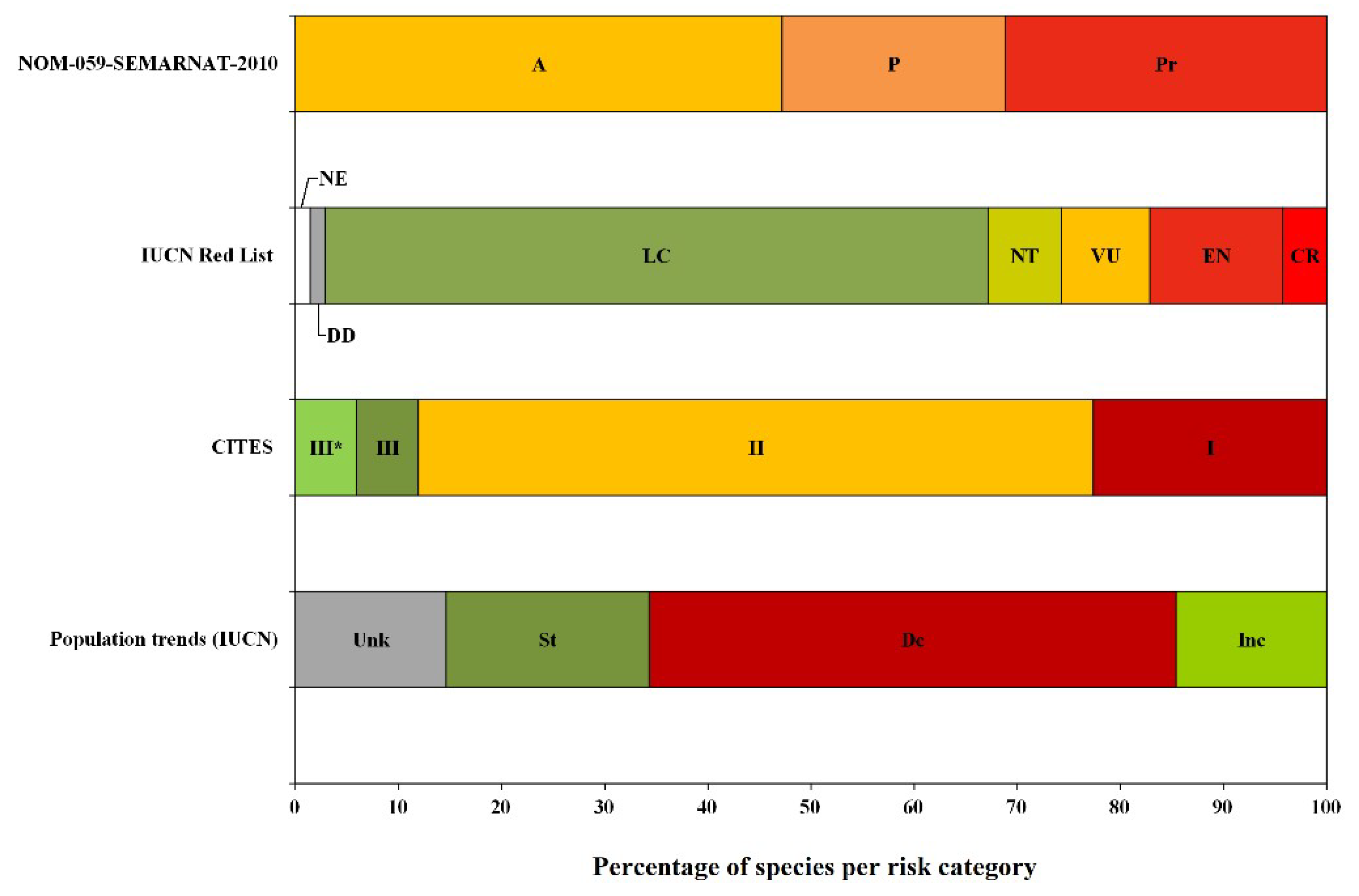
3.1. Characterization of the SUMA at a Regional Scale

The total number of UMAs registered for the three states is 1474, of which 499 are intensive and 975 are free-living. Of these, seven were removed from the official registry between 2012 and 2015, and 15 more had failed to provide a report or had no communication with SEMARNAT between 2013 and 2017, and as such were considered non-operating. Another 236 UMAs (145 intensive and 91 free-living) with some form of commercial use registered within their activities, had not received any authorization from SEMARNAT over the last six years (the period 2011–2012 to 2016–2017), for which reason these were also considered inactive. Finally, 382 UMAs (97 intensive and 285 free-living) had not emitted any report or received authorization of rate of use during the periods indicated, and these were therefore also considered inactive. After eliminating the UMAs lacking in reports and authorizations, the final number of active UMAs was 834 (which were considered in the analysis), of which 239 are intensive and 595 are free-living. These UMAs cover an approximate area of 427,635 ha, representing 2.5% of the total regional area and 1.2% of the total area of the SUMA at the national level. Of this area, 22,489 ha correspond to intensive UMAs and 405,149 ha correspond to free-living UMAs.
A total of 273 species with eight subspecies are managed in the UMAs in the studied area at a regional scale. These include 66 endemic species and one endemic subspecies; the orchid laelia (Laelia anceps dawsonii), 179 native species, 27 exotic species and one migratory insect species; the monarch butterfly (Danaus plexippus). Among these species are represented seven taxonomic classes of fauna (Mammalia, Aves, Actinopterygii, Reptilia, Amphibia, Insecta and Cnidaria), five of flora (Cycadopsida, Liliopsida, Magnoliopsida, Pinopsida and Pteridopsida) and two of fungi (Agaricomycetes and Pezizomycetes) (Figure 2). The taxonomic classes with the greatest presence in the UMAs are Aves, Reptilia and Liliopsida, represented by 72, 52 and 50 species, respectively. Of these, the white-winged dove (Zenaida asiatica), green iguana (Iguana iguana) and ponytail palm (Beaucarnea recurvata), respectively, are the most representative species. The taxonomic classes most frequently managed in the UMAs are Magnoliopsida and Mammalia, registered in 523 and 236 UMAs, and represented by 10 and 42 species, respectively.
Of the 273 species managed, the red cedar (Cedrela odorata), white-tailed deer (Odocoileus virginianus), ponytail palm (Beaucarnea recurvata) and a set of three mangrove species (Avicennia germinans, Laguncularia racemosa and Rizhophora mangle) are registered in the greatest number of UMAs. Species of ornamental, non-timber plants are managed mainly in the intensive UMAs in nurseries. These plants belong to the class Liliopsida and are mainly the ponytail palm (Beaucarnea recurvata) as well as different orchid species (e.g., Chysis bractescens, Laelia anceps, Stanhopea oculata and Stanhopea tigrina). Some reptiles, such as the pond slider turtle (Trachemys scripta) and the green iguana (Iguana iguana), are also common, and are managed on intensive UMAs, mainly breeding farms, as are some mammals such as the white-tailed deer (Odocoileus virginianus), collared peccary (Dicotyles tajacu) and the paca (Cuniculus paca). The free-living UMAs managed with greatest frequency different species of birds and mammals, mainly the white-winged dove (Zenaida asiatica), red-billed pigeon (Columba flavirostris), bobwhite quail (Colinus virginianus), white-tailed deer (Odocoileus virginianus), collared peccary (Dicotyles tajacu), paca (Cuniculus paca), armadillo (Dasypus novemcinctus) and eastern cottontail rabbit (Sylvilagus floridanus). Non-timber plants, such as different palms belonging to the genus Chamaedorea spp. (e.g., C. eliator, C. cataractarum, C. ernesti-augustii, C. glaucifolia, C. hopperiana, C. metalica and C. woodsoniana) are also managed at free-living UMAs, as well as some species of timber trees such as the red cedar (Cedrela odorata) and three mangrove species (Avicennia germinans, Laguncularia racemosa and Rizhophora mangle) (Figure 3).
In terms of categories of risk or protection of the species managed in the SUMA at a regional scale, 60.8% (166 species) are on the national list of species at risk [40], with most (76%) under the category of “Threatened” (A). A total of 72.5% (198 species) are on the Red List of the IUCN [46], where the category “Least Concern” (LC) is the most frequent (64.3%). Only 109 species (39.9%) are listed within CITES [47]. Also reported was a reptile species of the genus Pseudemys, the category of risk or protection of which is unknown due to the lack of identification of the species. However, according to the IUCN, the population trend of a large part of the managed species (51.1%) is currently categorized as “Decreasing” (Dc) [46] (Figure 4).

3.2. Analysis per Vegetation Type and Land Use

At a regional scale, the free-living UMAs cover nine of the 12 categorical vegetation type and land use at national scale: tropical montane cloud forest (TMCF), temperate forest (TF), mangrove (M), tropical humid forest (THF), tropical subhumid forest (TSF), hydrophilic vegetation (HV), halophilic and gypsophilic vegetation (HGV), induced or cultivated pasture (P) and other vegetation types (OV). The predominant vegetation types in the UMAs are THF, P and TMCF, which cover approximate areas of 141,948, 79,878 and 68,363 ha, respectively, followed by TF and M with approximate areas of 24,494 and 13,362 ha, respectively (Figure 5).
According to the official information of SEMARNAT [45] and the most recent National Report of Forestry and Soils [50], relative to conserved vegetation, THF constitutes 39.7% of the area of the regional SUMA and 1% of the total area of THF at a national scale, while TMCF represents 19.1% of the area of the regional SUMA and 4% of the total area of TMCF at a national scale. The TF constitutes 6.9% of the area of the regional SUMA and 0.1% of the total area of TF at a national scale, while the mangrove covers 3.7% of the total area of the regional SUMA and 1.5% of the total area of mangrove at a national scale. In the case of disturbed vegetation, P covers 22.4% of the area of the regional SUMA and 0.4% of the total area of P at a national scale, considering induced or cultivated pasture (Figure 5).

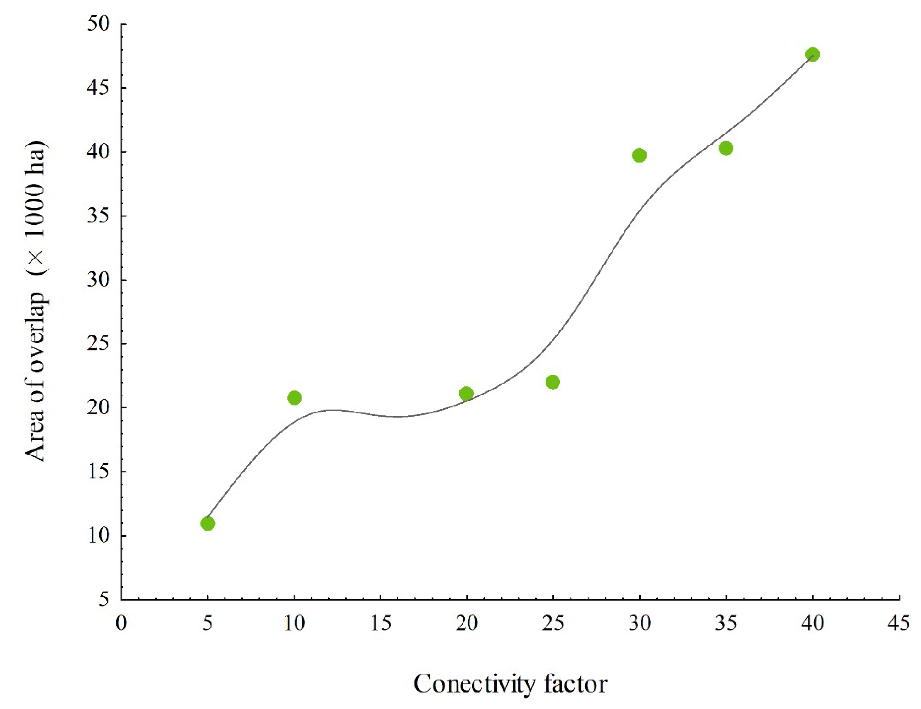
3.3. Spatial Analysis of the Optimum Factor of Potential Connectivity among the UMAs and Protected Areas for Conservation at a Regional Level

Of the connectivity factors tested in the spatial analysis, and based on the criteria of selection, factor 20 was suggested as the minimum factor desirable for potential connectivity among the UMAs at a regional scale (Appendix A). From the buffer zone generated for each UMA based on this factor, a total of 126 potential conservation areas were identified at a regional scale, with these areas understood to be integrated by the areas of the UMAs with overlapped buffer zones, as well as the area of the buffer zones themselves. Of these 126 areas, in two, more than 100 UMAs overlapped: one is the group of 189 UMAs close to the border between Chiapas and Tabasco (Figure 1b) and the second consists of 122 UMAs in the state of Chiapas (not shown in Figure 1b). The potential conservation area with the third greatest number of UMAs was located in the center of the state of Veracruz, where 81 UMAs overlapped (Figure 1b).
In the case of the first area (189 UMAs), the overlapping UMAs together accounted for an area of 21,095 ha, which, together with the area of their buffer zones, constituted a total potential conservation area of 4,555,350 ha. In the second area (122 UMAs), the overlapping UMAs together accounted for 5,711 ha, while the total potential conservation area was only 116,103 ha. Finally, for the third area in the center of the state of Veracruz (81 UMAs), the overlapping UMAs together covered an area of 7564 ha, comprising a total potential conservation area of 1,479,150 ha.

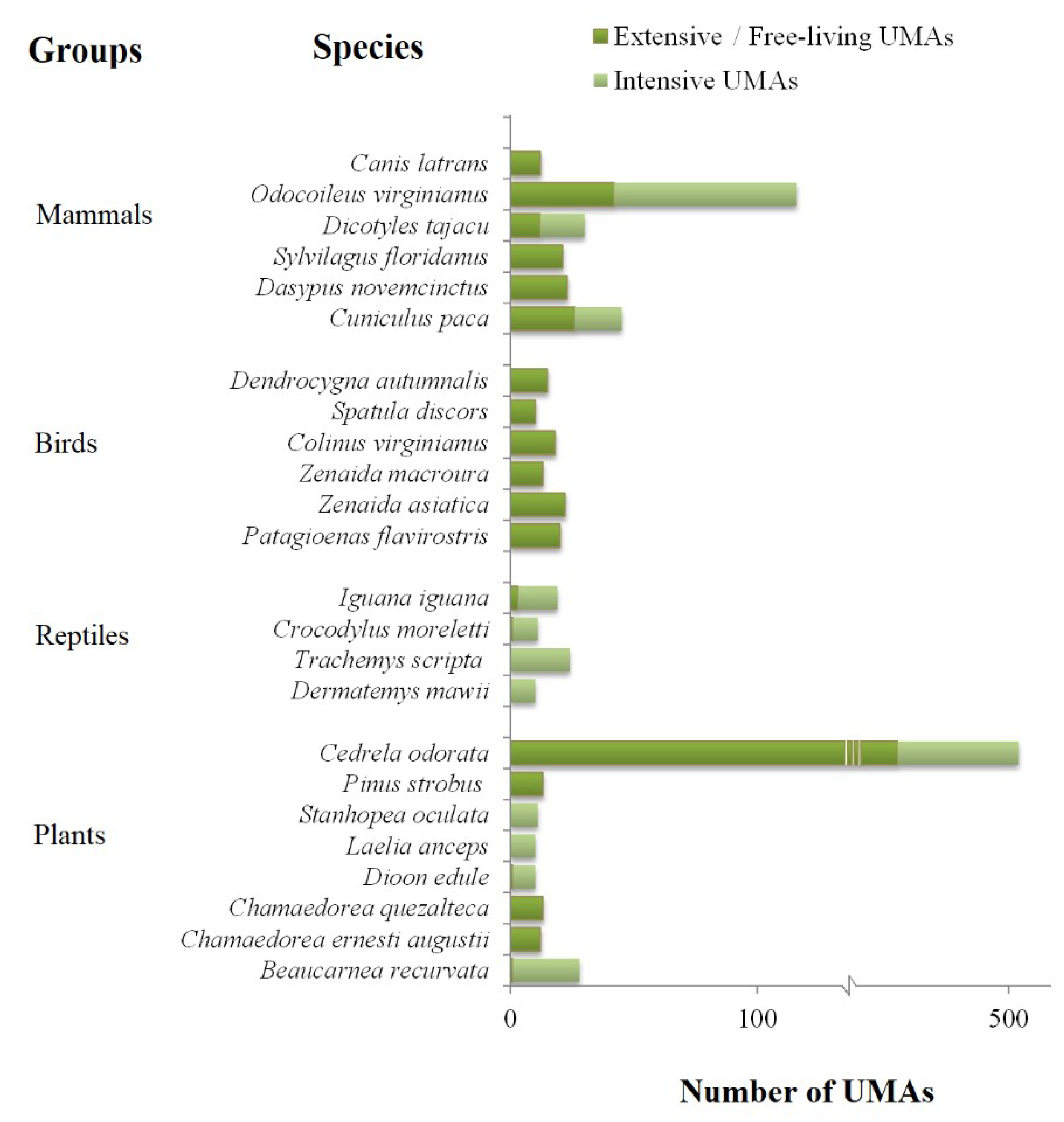
3.4. Evaluation of the Impact of UMAs on Wildlife Conservation in Southeast Mexico through the Selection of Representative Case Studies

3.4.1. Beaucarnea recurvata (Ponytail Palm)

The evaluation conducted for the inclusion of the genus Beaucarnea, Appendix II of CITES [47] reports that the wild populations of Beaucarnea recurvata are small, with a maximum density of 135 individuals per ha. At present, there is no updated and accurate estimate of the population size; limited regeneration is indicated along with a low establishment of seedlings due to the loss of habitat caused by land use change and the extraction of seeds and individual plants (seedlings, juveniles and adults) for their value as ornamental plants [47]. Despite the negative impact on wild populations, the population of cultivated and commercialized plants has increased, as well as their distribution, even at international level [51,52]. In the state of Veracruz alone, over the last five years (2012–2017), SEMARNAT has registered 29 units in the SUMA with authorization for exploitation and marketing of Beaucarnea recurvata. Of the 29 units, five cultivate the species B. pliabilis and B. gracilis. However, the size of these units is unfavorable for habitat conservation, since only one is registered as a free-living UMA with 524 ha of area, and the rest are intensive UMAs with areas of less than 3 ha [45].
In terms of conservation, the UMAs can act to reduce predation of wild individuals and can therefore also reduce deforestation of some remnants of conserved vegetation. In the socioeconomic dimension, production of Beaucarnea has had a significant impact since this is an endemic species of high commercial value as an ornamental plant. In this context, the value chain concept makes it possible to identify the social actors involved in the care of the species and its commercialization, as well as to identify how the price of specimens changes from their habitat to the final purchaser [53]. Unfortunately, according to an analysis of this value chain, conducted by a team of researchers from The Institute of Ecology A. C. (INECOL) [53], the least favored actors are the owners who still conserve fragments of tropical low deciduous forest, while the most favored are those that commercialize this species in cities. This situation implies a risk for the sustainability of the value chain and also for the wild populations since these form part of an ecosystem that is undergoing fragmentation due to land use change and the development of agroecosystems that are incompatible with biodiversity conservation. This is the result of the non-equitable distribution of the benefits and the lack of a significant return for the landowners and communities that inhabit the tropical low deciduous forests [51,52]. The institutional dimension, as well as that of the management of the scheme of conservation, reflects a lack of traceability of the products derived from the UMAs of the genus Beaucarnea. Moreover, there is the possibility of extraction of wild seeds, seedlings, juveniles and adults fraudulently certified under a legal production within the SUMA.

3.4.2. Avicennia germinans, Laguncularia racemosa and Rhizophora mangle (Mangroves)

Mangroves are diverse ecosystems of great ecological importance that provide a great variety of environmental services. They are considered feeding and refuge zones for a great diversity of wild flora and fauna, in addition to acting as a biological filter and a barrier against natural phenomena [54]. In Mexico, the mangroves have been directly and indirectly impacted by agricultural, livestock production, aquacultural and touristic activities. The region has two intensive and eight free-living mangrove UMAs registered. Within the modality of free-living UMAs, several have the objective of conservation and sustainable use of the mangrove; these include three species commonly known as red mangrove (Rhizophora mangle), black mangrove (Avicennia germinans) and white mangrove (Laguncularia racemosa). A fourth species, the button mangrove (Conocarpus erectus), is only managed in intensive UMAs. The management objectives are prominent for their contribution to the biological conservation of mangrove ecosystems and rural development [54,55]. The latter is achieved through the production of timber for the construction of houses and production of charcoal, which can imply a socioeconomic benefit for the owners of the UMAs.
These mangrove management units cover an area of 7525 ha [56] and are managed by different ejido lands, a modality of land tenure in which the administration and management of resources is organized in a collective manner. Through this modality, governance of the mangrove UMAs management promotes the participation and collective decision-making of a large number of rural actors. From the constitution of these UMAs, the development of previously prohibited productive activities has been promoted in the mangrove ecosystems, encouraging legal trade. The ejido members involved in its management can now legitimize the use of the mangrove as a licit, ordered and sustainable activity [54,55,56]. The experiences of these members have been shared with other communities, favoring close links among peasants, building of capacities and the establishment of internal rules. In terms of the objectives of conservation, activities of repopulation and restoration are promoted in the mangrove, which are species subject to national and international protection [40,46]. Likewise, conservation of the mangrove ecosystem is promoted, since its protection ensures the provision of ecosystem services and the formation of biological corridors [54,55].

3.4.3. Cedrela odorata (Red Cedar)

Due to its properties, the red cedar (Cedrela odorata) has been a forestry species preferred by human populations. However, due to the good quality of its timber, its natural populations have been placed at risk. Both its distribution areas and wild populations have been diminished considerably by intensive extraction of its timber in Mexico and in Mesoamerica in general [57]. Together with climatic change, overexploitation of this resource has caused deterioration and reduction of its habitat, as well as a loss of biodiversity [58]. This situation led to the inclusion of red cedar in Appendix III of CITES [47], as well as a species subject to special protection (Pr) according to Mexican environmental laws [40]. It is distributed in the three states that comprise the study area (Chiapas, Tabasco and Veracruz), generally as a cultivated tree since its presence in wild form is rare or null due to overexploitation and clandestine felling. Nevertheless, it is an important part in the structure of family orchards, mainly for the ethnic groups found in the region, and also as a shade tree on livestock ranches or commercial forestry plantations as promoted several years ago by the National Forestry Commission (CONAFOR, by its Spanish acronym).
In order to reduce the pressures to which the red cedar is subject, actions of restoration, conservation and management were implemented for the sustainable use and future conservation of the species [59]. Since it is subject to special protection within the Mexican environmental laws [40], from the year 2002, sustainable use of the red cedar as timber began to be regulated by the General Law of Wildlife (LGVS, by its Spanish acronym) under the UMA system. There are 514 red cedar UMAs registered at the regional scale, of which 458 are free-living and 56 are intensive. With respect to the free-living UMAs, despite being registered as such, the areas of these UMAs range from 0.3 to 2720 ha. The main activity of the red cedar UMAs is related to conservation through management and sustainable use of the species based on the growth curves of individuals.

3.4.4. Odocoileus virginianus (White-Tailed Deer)

The white-tailed deer is medium-sized cervid (males can weigh between 33 kg and 135 kg depending on the subspecies, with females weighing between 20% and 40% less than males). Only the males present antlers that change each year. It is one of the species of widest distribution in Mexico (apart from the peninsula of Baja California), with a total of 14 known subspecies. Of these, three are distributed within the study area: O. v. veraecrucis, O. v. thomasi and O. v. nelsoni. The white-tailed deer is the most important hunting species in Mexico and one that contributes significantly in economic terms, particularly in the northern states [24,25]. It can occupy a broad diversity of ecosystems, although it prefers tropical low deciduous forest, mixed pine-oak forest, oak forest and xerophilic scrub [60,61,62]. In general, it reproduces once per year; gestation lasts approximately seven months, and one or two young are born between July and August. Population density ranges from <1 ind/km2 (O. v. thomasi, [63] and O. v. nelsoni, [64]) to >10 ind/km2 (O. v. veraecrucis, [65]).
In addition to its value for hunting, it presents a charismatic image [66] that has made the species a symbol for nature protection, thus contributing indirectly to the conservation of habitat and secondary species. From the pre-Columbine cultures, it has had a high value as a source of food and ornaments, with curative and ceremonial properties [67], mainly for rural communities. For this reason, the deer are increasingly incorporated into productive activities, both private and communal [68]. Moreover, the legal possibility of obtaining economic benefits from the use of the white-tailed deer have influenced a change in attitude in terms of caring for and recovering the habitat and its local populations in some rural communities of the country [69]. While there are 41 free-living UMAs in the region, presenting areas that range from one to 5250 ha, most are intensive UMAs (69), with areas that range from 0.02 to 201 ha. For this reason, only the free-living UMAs are considered to effectively influence the conservation of biodiversity, since they attempt to preserve or improve the habitat, thus benefitting many species of flora and fauna, as well as significantly contributing to connectivity with other conservation zones such as the Natural Protected Areas (NPA).

4. Discussion

The development of management strategies by the Mexican government implies an exponential increase in the number of UMAs, resulting in a diminished capacity for monitoring by SEMARNAT [70]. Moreover, factors such as the lack of coordination among the different governmental levels, dependencies and the different sectors involved, as well as the lack of indicators and metrics of program evaluation [28], the lack of a comprehensive evaluation of the results in terms of effectiveness for the conservation of wild populations and the economic benefits, and the lack of monitoring and the difficulty of periodic communication with the representatives of the UMAs, constitutes the main problems of the SUMA.
Also, the need to standardize, systemize and update the official databases is highlighted, since inconsistencies were detected among the information compiled from different official sources (SEMARNAT Delegations of Chiapas, Tabasco and Veracruz and SEDEMA), constituting the main obstacles we faced in this study. For this reason, the number of active UMAs and the area of coverage of conservation could have been underestimated for the national territory, as highlighted by Urquiza Haas [71].
This gap in the information has contributed negatively to the perception of the impact and the effectiveness of this conservation policy at a national scale. In the case of the environment, public policies must be designed and managed based on proven diagnostics and valid and verifiable contents, since these policies assume a set of actions within a given geographic space [72]. In this sense, the need for key information that allows the carrying out of diagnostics to direct decision-making in management becomes even more important [73]. It could be said that the UMA scheme has been successful given the examples of the UMAs of white-tailed deer in the north of Mexico, which have generated important economic yields through hunting and favored habitat conservation that has facilitated the conservation of other species of fauna. However, given the biological, socioeconomic and cultural heterogeneity of Mexico, it is necessary to conduct evaluations at a regional scale in order to improve the degree of effectiveness of this policy of conservation [6,31,74].
We have detected key elements of the current status of the SUMA at a regional scale and the form in which it contributes to wildlife conservation in Mexico. Of the UMAs registered and active at the time of analysis, all manage species under some category of risk according to the different national and international lists [40,52,54]. However, only 7.1% present within their management plans some priority species considered within the Program of Conservation of Species at Risk (PROCER, by its Spanish acronym) [75,76]. This suggests that, even though SEMARNAT incorporated the Projects of Conservation and Recovery of Priority Species (PREP, by its Spanish acronym) into the UMAs program in 2007 [26,70], it remains necessary to seek suitable strategies for the improvement of species that are compatible with this conservation scheme.
Given that most of the priority species are seriously threatened or in danger of extinction, many are not subject to commercial exploitation in an extractive mode or one of derived products. One exception is presented by the UMAs of mangrove (Avicennia germinans, Laguncularia racemosa and Rhizophora mangle), which are mostly free-living UMAs in which, despite the fact that two of these are priority species, extractive exploitation is authorized and regulated through the UMA scheme. In this sense, the establishment of intensive UMAs for the main purpose of providing refuge for a species, with no objectives of reproduction, rehabilitation and/or prerelease and with small areas, does not actively contribute to the conservation and recovery of wild populations of the species in question. One effective strategy of greater impact, as proposed in this study, consists of promoting the establishment of free-living UMAs that contribute to increasing the area dedicated to conservation, through the incorporation of larger UMAs or those that are strategically grouped in areas of priority ecosystems that can favor connectivity between themselves and other conservation areas, such as the NPA [74] and areas dedicated voluntarily for conservation (ADVC). In this way, while the UMAs may not be destined for the management of determined species, their maintenance of the habitat implies that the conservation areas will potentially favor recovery through connectivity of ecological corridors. Another alternative strategy consists of driving the establishment of UMAs dedicated to conservation through environmental education, and ecotourism and ecosystem services that favor UMAs dedicated to the management of priority species or incorporating them into their management plans, together with other species of commercial or hunting use.
The results also reveal that 2.9% of the UMAs manage exotic species, which, while legally considered in the program, constitutes a strategy that does not contribute effectively to conservation of the native wildlife [77]. Moreover, attention must be given to the potential problems such as possible escapees, seed dispersion, and thus their introduction into habitats outside of their distribution range, contributing to an increase in the incidence of invasive species, as indicated in the National Strategy of Invasive Species [78,79], or even the transmission of diseases to native and domestic species. Other factors must also be considered, such as the lack of adaptation of the species or availability of resources or suitable infrastructure for their maintenance, since release of these individuals is not an ecologically viable option. The same situation must be considered for subspecies outside of their normal distribution area, as is the case with O. v. texanus, preferred for hunting because the males, due to the size of their antlers, are considered better trophies, in detriment to the local subspecies (and to their genetic variability) that do not present this characteristic.
On the other hand, as a positive aspect, we highlight the 8.3% of UMAs that include endemic species in their management plans. Their protection and sustainable management contributes significantly to the conservation of native wildlife [80]. Moreover, 94.3% of UMAs are focused on the management of native species. The growing interest over recent years in the conservation and management of these species was the result of an effective strategy driven by SEMARNAT in 2010 to grant subsidies for native wildlife [26]. This strategy has the objective of strengthening the integrated management of the habitat and of these populations through projects that allow the sustainability of their populations with a legal market of goods and services generated [26].
Many studies of conservation worldwide suggest that, in addition to protecting the most important ecosystems of the planet, one of the main principles is also to protect the largest possible area of habitat [81,82]. In the case of reserves or natural protected areas, for example, the area of conservation is directly related to the viability of the wild populations, species richness and rates of immigration, among other factors [83]. In the case of the free-living UMAs, the reason lies more in the form in which they contribute to increasing the area dedicated to conservation, improving the connectivity among conserved areas and thus favoring the metapopulation dynamics of many wild species [84].
In addition, free-living UMAs help in turn to conserve ecosystems of great importance such as the mangroves, tropical montane cloud forest, temperate forest, tropical humid forest, tropical subhumid forest and hydrophilic, halophilic and gypsophilic vegetation, [24,26,85,86], as well as the species associated with these. One clear example of free-living UMAs that contribute both to the area of conservation and to the protection and restoration of complete ecosystems is presented by the UMAs of mangrove (Avicennia germinans, Laguncularia racemosa and Rhizophora mangle), which in the state of Tabasco alone correspond to 26% of the total number of UMAs registered statewide and cover an area within the regional SUMA that comprises 3.74% of the total area [45], in addition to their important role as regulators of environmental phenomena on the coast.
We emphasize the importance of promoting these free-living UMAs and also suggest that they should cover a minimum area based on the spatial analyses and evaluations of indices of connectivity [74]. In the case of the mangrove, it would be a very effective strategy to promote UMAs that manage this type of timber species, since the study area alone contributes around 17% of the total area of mangrove at a national scale (according to the most recent cartographic map of base lines of mangroves that dates from 2010) [49,50,55]. In addition, it should be noted that the white and black mangroves (Laguncularia racemosa and Avicennia germinans) are considered priority species [76], for which reason this strategy would fulfill a twin purpose.
The same case could be replicated with other priority species managed in UMAs, for example, vascular plants such as Beaucarnea gracilis, Zamia furfuracea and Chamaedora metalica; birds such as Colinus virginianus, Ara macao and Ara militaris; mammals such as Alouatta palliata, Ateles geoffroyi and Tayassus pecari; amphibians such as axolotl (Ambystoma mexicanum) and insects such as the monarch butterfly (Danaus plexippus). Many of these are native to the tropical humid forest and tropical montane cloud forest at a regional scale [84]. Likewise, other species (priority or otherwise) could be included in the management; conservation of these species may favor or contribute directly or indirectly to the conservation of ecosystems and secondary species, as is the case with the free-living UMAs of white-tailed deer (Odocoileus virginianus) [24,60,61,62,68,87]. For this reason, currently around 14% of the regional SUMA is constituted by UMAs in which this species is managed.
Another potential strategy is to incentivize UMAs for managing species that, while they may not be a priority, are under some category of severe risk, for example, species of the genus Beaucarnea (B. recurvata and B. pliabilis) [40,47]. According to the results at a regional scale, conservation of this type of species (non-timber, slow growing, high commercial and aesthetic value) [51] is conducted mainly in small intensive UMAs. Its contribution in terms of conservation area is therefore not significant; however, it can contribute to reducing the illegal harvest of seeds and predation of wild individuals directly from their natural habitat, which are together the main sources of pressure on these species [47]. Furthermore, the development of seed banks of legal origins contributes to protecting the genetic reservoir of these species under threat of extinction [40,58].
In contrast to these examples are the UMAs of red cedar (Cedrela odorata), which constitute the greatest number of UMAs in the studied region (61.6%). Given that the red cedar and mangrove are both listed in the NOM-059-SEMARNAT-2010 [40] under some category of risk, and in conformity with the current legislation, their legal economic use is only possible through the UMA scheme. This change caused, from 2010, an increase in the number of free-living UMAs in Chiapas, Tabasco and Veracruz. This also reflects governmental initiatives implemented by the National Forestry Commission (CONAFOR, by its Spanish acronym), which promotes the establishment of commercial forestry plantations on land formerly used for agriculture and livestock production or areas that have lost their natural forest vegetation. This reforestation strategy is authorized with a minimum area of 5 ha and, although part of the objectives of sustainable forestry use is the conservation of biodiversity and maintenance of ecological processes, at least in the specific case of the red cedar, the result has been an explosion in the establishment of monocultures, which are managed with periodic clearings [88].
The problem of the monocultures is related directly to the loss of biodiversity; they generate an effect similar to the syndrome known as “empty forest” [89,90,91]. The presence of tropical trees within a mature forest with the capacity for exploitation is generally considered a measure of the degree of conservation of the diversity of flora and fauna within the tropical forests [89]. However, the presence of trees with these qualities does not guarantee the presence of a resident fauna [89,92]. In this way, plantations of cedar and other forestry species reduce the biodiversity of flora and, as a consequence, also impact the fauna, since this plantation type does not constitute suitable habitat for the many animals that cannot survive without the natural biodiversity of the forests that provides them with food and refuge [89]. Likewise, defaunation has a direct impact on the flora, since a loss of fauna implies a loss of functions of dispersion, thus favoring only those plant species that disperse abiotically or through the actions of small birds and mammals over those that depend on the dispersion capacity of medium to large birds and mammals [93].
In this sense, the particular case of the UMAs of red cedar represents a clear example of the lack of articulation of governmental policies for environmental management; they are contradictory initiatives of conservation and exploitation of resources. The lack of communication among federal dependencies is a serious issue that presents errors in planning and favors the interests of particular social actors and limits the success of the UMAs or of any program of public administration.
In the case of the mangrove, given the great importance of its environmental and economic functions, CONAFOR began an ambitious program of restoration in 2013 in more than 7000 ha of mangrove, testing a methodology that demonstrates the recovery of deteriorated mangrove ecosystems [88]. This restoration project created temporary employment and an economic input for the local communities, as well as the opportunity to implement management programs that permit their use and are compatible with the UMA scheme.
Finally, through the planning and execution of the different strategies suggested here, we highlight the need to conduct explorations and spatial approaches prior to implementing any of these ideas. Indeed, we suggest spatial analysis as an instrument with which to determine priority zones for the establishment of UMAs and to determine the parameters that these must fulfill for incorporation into the SUMA. This type of analysis constitutes an innovative technique in decision-making and conservation management [74], since it informs decision-making and allows identification of priority zones for conservation based on connectivity (structural and functional), permitting the establishment of spatial patterns within the landscape [94,95,96]. Some practical examples are the Integral Index of Connectivity (IIC), Index of Probability of Connectivity [97] and the Morphological Analysis of Spatial Patterns [94,95,96].
Some current conservation strategies of Mexico and Latin America, such as the Program of Areas of Importance for the Conservation of Birds (AICAS, by its Spanish acronym) [98], Program of Priority Regions for the Conservation of Biodiversity, Project of Priority Terrestrial Regions (RTP, by its Spanish acronym) [99] and the Strategy of Coordination of the Selva Maya and the Mesoamerican Biological Corridor [100], are based on this type of methodology. In addition, there are other indigenous and peasant initiatives, such as the Community Reserves and the Areas Destined Voluntarily for Conservation (ADVC) [26], among others, that use other criteria of analysis for the detection of environmental units, the physical and biotic characteristics of which favor conditions that are particularly important from the point of view of biodiversity conservation. Once these areas are defined, links are determined among them, proposing low impact developments to maintain the corridors or “stepping stones” that favor connectivity between core areas [75,101,102] (in all cases, the aim of connecting areas destined for conservation is to increase the potential conservation area). In this sense, the SUMA, as with the NPA and other priority areas, should contribute in turn to increasing the area of conservation at local scale, as well as at regional and national scales.
For this, prior to evaluation of functional connectivity, which represents the specific responses of movement or dispersion of each species to different elements of the landscape [83,93], consideration must first be given to the structural connectivity. The aim is to prioritize areas suitable for promoting the establishment of UMAs, whether for habitat conservation, priority species, species under some category of risk or wildlife in general, thus precluding in the first instance, the possible registering of UMAs that are isolated or located in non-priority zones.
Once structural connectivity is established, evaluation can begin of the specific functional connectivity of each species of interest in the same landscape and even for the same species in different landscapes. While structural connectivity does not necessarily imply functional connectivity [103,104], it does represent a first approach, understood as “the degree to which the landscape facilitates or impedes movement or dispersion through the patches” (among the UMAs and between the UMAs and other conservation areas) [103,104]. Once the structural connectivity is evaluated, it is possible to configure the physical arrangements of spatial structures: in this case, clusters of UMAs that achieve an effective connectivity of the landscape among areas dedicated to or destined for conservation.
Based on our results, we propose a minimum desirable factor of potential connectivity of 20 (20 times the area of the UMA), which achieves connection with surrounding UMAs, reserves, NPA, or ADVC. The size of the UMAs for potential registration will then depend on this factor of connectivity. Given that the size of the buffer zone (area of influence) depends on the size of the area of the UMA, very small UMAs may require connectivity factors that are too large to achieve connection. On the other hand, application of the same connectivity factor for all of the UMAs would cause very large UMAs to be highly valued even when these possibly include zones of agriculture or livestock production and those of high anthropogenic activity, even including urban zones.
For this reason, the initiatives we propose point to encouraging the establishment of free-living rather than intensive UMAs. However, the permanence of some intensive UMAs is not completely discarded (subject to evaluation of priority areas for their establishment and the species to be managed), for example the UMAs of the genus Beaucarnea spp., since according to some authors [75,93], small patches (small UMAs) can contribute to the functional connectivity of the landscape as “stepping stones”.
This dynamic of evaluation to connect UMAs and conservation areas in Mexico is comparable with some strategies that have already been tested in other Latin American countries, such as Brazil [75]. Through this process, which seeks to promote the metapopulational dynamic of the species [86], and the flow and displacement of species through feasibly connected areas, it has been possible to successfully connect conserved remnants of forest. In this example, most of the areas that fulfill functions of key connectors between core areas are zones of non-restrictive protection, in which exploitation and land use must coexist with conservation, as currently proposed by the UMA model in Mexico.
In conclusion, the SUMA in the southeastern region of Mexico faces administrative problems related to poor interinstitutional communication, lack of standardized evaluation indicators and systematization and updating of information. Of the 273 species managed at the regional scale, the SUMA have had an impact mainly on those species that are in some category of risk, although specific evaluations are still lacking to determine the impact of management on the demography of wild populations. On the other hand, the two types of UMAs (intensive and free-living) must be evaluated differentially for their particular administrative characteristics, as well as to adapt the evaluation indicators in terms of their contribution to conservation. In their case, intensive UMAs, have a limited contribution to the conservation of wild populations of the managed species. There are few cases where intensive UMAs have breeding programs for threatened species. While it is feasible to propose strategies that provide economic incentives to promote the management of endemic and threatened species, it should be noted that, according to the legal approach of the UMA scheme, the objective is not for the government to subsidize operation of the UMA, but rather that they are self-sustaining. We propose to promote the establishment of free-living UMAs that would contribute to increase the conservation areas, by incorporating larger areas for conservation or that UMAs be established strategically in corridor areas of priority ecosystems that favor connectivity between UMAs, and other conservation schemes such as protected areas and voluntary community conservation lands. Also, it is necessary to review and reorient the UMA scheme of forest monocultures, although they may be considered in connectivity but not in terms of conservation of biodiversity, since they do not constitute an adequate habitat for many species, and administratively, they do not promote the articulation of government policies for conservation management.

Author Contributions

Conceptualization, C.A.-P., A.C.-H., S.G.-T., M.P.-V. and A.O.-A.; Methodology, C.A.-P., A.C.-H., M.P.-V. and A.O.-A.; Software, R.L.; Formal Analysis, C.A.-P., M.P.-V. and R.L.; Investigation, C.A.-P., S.G.-T., M.P.-V. and C.T.-C.; Resources, S.G.-T., M.P.-V. and C.T.-C.; Data Curation, C.A.-P., M.P.-V. and C.T.-C.; Writing—Original Draft Preparation, C.A.-P.; Writing—Review & Editing, A.C.-H., S.G.-T. and A.O.-A.; Visualization, C.A.-P., A.C.-H., S.G.-T. and A.O.-A.; Supervision, A.C.-H. and A.O.-A.; Project Administration, A.C.-H., S.G.-T., A.O.-A. and C.T.-C.; Funding Acquisition, A.C.-H.

Funding

This research was funded by the CONSEJO NACIONAL DE CIENCIA Y TECNOLOGÍA (CONACYT) through the project “Evaluation of the Management Units for the Conservation of Wildlife (UMAs) as a national conservation policy”.

Acknowledgments

This study was supported by the Consejo Nacional de Ciencia y Tecnología (CONACYT) through the project “Evaluation of the Management Units for the Conservation of Wildlife (UMAs) as a national conservation policy” (PN-4106/2016) with the Instituto de Ecología A.C. (INECOL) and in collaboration with El Colegio de la Frontera Sur (ECOSUR) and the Universidad Autónoma de Chiapas (UACH). We appreciate the collaboration of the Secretaría del Medio Ambiente y Recursos Naturales (SEMARNAT) in the federal offices and the Delegations of Chiapas, Tabasco and Veracruz for the facilities provided for accessing the official SUMA databases. We especially thank those who collaborated in the development of this study by providing information, databases, cartography and supporting with information analysis; Angélica Hernández Guerrero, Carlos I. Flores Romero, Uriel Echavarría Dominguez and Luis M. García Feria. We also want to thank those who reviewed earlier drafts of this manuscript; Ricardo Contreras Osorio, Alberto González Romero, Luis M. García Feria, Luciana Porter Bolland, three anonymous Reviewers and an anonymous Academic Editor for their valuable comments, as well as Keith MacMillan for translation of the text into English.

Conflicts of Interest

The authors have no conflicts of interest to declare.

Appendix A

Figure A1. Approximation of the relationship between the connectivity factor and the area of overlap between UMAs with Weighted Least Squares fit.
Sustainability 10 04415 g0a1
In a linear regression based on the conventional least squares method, requirements must be fulfilled: (1) that there is no correlation between variables; (2) that the values of independent variable X are free of error; and (3) that the associated error of the dependent variable Y has a normal distribution. If requirements 2 and 3 are not met, the method of Weighted Least Squares (WLS) can be applied.
The WLS method does not fit to the data one function that can be easily described by a single formula and plotted independently from the data. But the method fits a curve to the data by a second-order polynomial regression which is calculated for each value on the X independent variable scale to determine the corresponding Y dependent variable value such that the influence of the individual data points on the regression (i.e., the weight) decreases with their distance from the particular X independent variable value (i.e., sums of squares).
The application of WLS fitting on the connectivity factor and its associated uncertainty versus the overlap area [according to the four criteria, see section (B) Spatial analysis of the optimum factor of potential connectivity among the UMAs and the area dedicated to conservation at regional level] of the calculated buffers for the UMAs that depend on their surface indicates that the connectivity factor 20 has the minimum value that adjusts with the overlap area (Figure S1). The upper factor values also adjust, but while the overlap area increases also overlap with cities, villages, highways, crops, livestock production lands, and others areas with high human activities. Then, the great overlap area is an artifact where not increase the real habitat area for wildlife.

References and Note

  1. Achard, F.; Eva, H.D.; Stibig, H.-J.; Mayaux, P.; Gallego, J.; Richards, T.; Malingreau, J.-P. Determination of Deforestation Rates of the World’s Humid Tropical Forests. Science 2002, 297, 999–1002. [Google Scholar] [CrossRef] [PubMed]
  2. Balmford, A. Economic Reasons for Conserving Wild Nature. Science 2002, 297, 950–953. [Google Scholar] [CrossRef] [PubMed] [Green Version]
  3. Ferraro, P.J.; Simpson, R.D. The Cost-Effectiveness of Conservation Payments. Land Econ. 2002, 78, 339–353. [Google Scholar] [CrossRef]
  4. Ferraro, P.J.; Kiss, A. Direct Payments to Conserve Biodiversity. Science 2002, 298, 1718–1719. [Google Scholar] [CrossRef] [PubMed]
  5. Kiss, A. Is community-based ecoturism a good use of biodiversity conservation funds? Trends Ecol. Evol. 2004, 19, 232–237. [Google Scholar] [CrossRef] [PubMed]
  6. Weber, M.; García-Marmolejo, G.; Reyna-Hurtado, R. The Tragedy of the Commons: Wildlife Management Units in Southeastern Mexico. Wildl. Soc. Bull. 2006, 34, 1480–1488. [Google Scholar] [CrossRef]
  7. Ojasti, J.; Food and Agriculture Organization of the United Nations. Utilización de La Fauna Silvestre En América Latina: Situación y Perspectivas Para Un Manejo Sostenible; FAO Conservation Guide; FAO: Rome, Italy, 1993. [Google Scholar]
  8. Townsend, W. La Participación Comunal En El Manejo de Vida Silvestre En El Oriente de Bolivia. Manejo de Fauna Silvestre en la Amazonía 1997, 105–109. [Google Scholar]
  9. Townsend, W.R. Algunas Técnicas Para Ampliar La Participación En El Manejo de La Fauna Silvestre Con Comunidades Rurales; Conservación de Fauna Silvestre en América Latina; Instituto de Ecología: La Paz, Bolivia, 1999; pp. 141–145. [Google Scholar]
  10. Monroy-Vilchis, O.; Cabrera, L.; Suárez, P.; Zarco-González, M.M.; Rodríguez-Soto, C.; Urios, V. Uso Tradicional de Vertebrados Silvestres En La Sierra Nanchititla, México. Interciencia 2008, 33, 308–313. [Google Scholar]
  11. Pérez Gil Salcido, R.; Monroy, J.; Salcedo, M.; Gómez, T.; Gabrielacoaut, M. Importancia Económica de Los Vertebrados Silvestres de México; Comisión Nacional Para el Conocimiento y Uso de la Biodiversidad, CONABIO: Ciudad de México, México, 1995; ISBN 968-7728-00-0. [Google Scholar]
  12. McGinlay, J.; Parsons, D.J.; Morris, J.; Hubatova, M.; Graves, A.; Bradbury, R.B.; Bullock, J.M. Do Charismatic Species Groups Generate More Cultural Ecosystem Service Benefits? Ecosyst. Serv. 2017, 27, 15–24. [Google Scholar] [CrossRef]
  13. Browder, J.O. Lumber Production and Economic Development in the Brazilian Amazon: Regional Trends and a Case Study. J. World For. Resour. Manag. 1989, 4, 1–19. [Google Scholar]
  14. Nepstad, D.C.; Schwartzman, S. Non-Timber Products from Tropical Forests. Evaluation of a Conservation and Development Strategy; New York Botanical Garden: New York, NY, USA, 1992. [Google Scholar]
  15. Valdez, R.; GuzmáN-Aranda, J.C.; Abarca, F.J.; Tarango-AráMbula, L.A.; SáNchez, F.C. Wildlife Conservation and Management in Mexico. Wildl. Soc. Bull. 2006, 34, 270–282. [Google Scholar] [CrossRef]
  16. Boege, E. El Patrimonio Biocultural de Los Pueblos Indígenas de México: Hacia La Conservación In Situ de La Biodiversidad y Agrodiversidad En Los Territorios Indígenas, 1st ed.; Instituto Nacional de Antropología e Historia: México D. F., México, 2008; p. 342. [Google Scholar]
  17. Challenger, A. Utilización y Conservación de Los Ecosistemas Terrestres de México: Pasado Presente y Futuro; Comisión Nacional para el Uso y Conocimiento de la Biodiversidad (CONABIO); Instituto de Biología Universidad Autónoma de México (UNAM); Agrupación Sierra Madre: México D. F., México, 1998; p. 847. [Google Scholar]
  18. Comisión Nacional para el Conocimiento y Uso de la Biodiversidad, CONABIO. 2014. Available online: https://www.gob.mx/conabio/prensa/comercio-internacional-de-especies?idiom=es (accessed on 15 May 2018).
  19. De Alba, E.; Reyes, M. Valoración económica de los recursos biológicos del país. In La Diversidad Biológica de México: Estudio de País; Peña-Jiménez, A., Neyra-González, L., Loa-Loza, E., Durand-Smith, L., Eds.; Comisión Nacional para el Uso y Conocimiento de la Biodiversidad, CONABIO: Ciudad de México, México, 1998; pp. 2–23. [Google Scholar]
  20. Peña-Jiménez, A.; Neyra-González, L. Amenaza a la biodiversidad. In La Diversidad Biológica de México: Estudio de País; Peña-Jiménez, A., Neyra-González, L., Loa-Loza, E., Durand-Smith, L., Eds.; Comisión Nacional para el Uso y Conocimiento de la Biodiversidad, CONABIO: Ciudad de México, México, 1998; pp. 157–181. [Google Scholar]
  21. Instituto Nacional de Ecología. Indicadores de Desarrollo; Estrategia Nacional para la Vida Silvestre: Ciudad de México, México, 2000. [Google Scholar]
  22. Sisk, T.D.; Castellanos, V.A.E.; Koch, G.W. Ecological Impacts of Wildlife Conservation Units Policy. in Mexico. Front. Ecol. Environ. 2007, 5, 209–212. [Google Scholar] [CrossRef]
  23. García-Marmolejo, G.; Escalona-Segura, G.; Van Der Wal, H. Multicriteria Evaluation of Wildlife Management Units in Campeche, Mexico. J. Wildl. Manag. 2008, 72, 1194–1202. [Google Scholar] [CrossRef]
  24. Espino-Barros, O.A.V.; Viera, R.G.; Franco, F.J.; Hernández, J.E.H.; Castañón, S.R. Evaluación de las unidades de manejo para la conservación de la vida silvestre del venado cola blanca en la región Mixteca, México. Zootecnia Trop. 2008, 26, 395–398. [Google Scholar]
  25. Gallina-Tessaro, S.A.; Hernández-Huerta, A.; Alejandro, C. Unidades para la conservación, manejo y aprovechamiento sustentable de la vida silvestre en México (UMA). Retos para su correcto funcionamiento. Investigación Ambiental Ciencia y Política Pública 2009, 1, 143–152. [Google Scholar]
  26. Secretaría del Medio Ambiente y Recursos Naturales, SEMARNAT. 2017. Available online: https://www.gob.mx/semarnat/articulos/las-uma-sitios-dedicados-a-la-conservacion-de-la-vida-silvestre (accessed on 20 May 2018).
  27. Comisión Nacional de Áreas Naturales Protegidas, CONANP. 2017. Available online: https://www.gob.mx/conanp/acciones-y-programas/preguntas-frecuentes-de-areas-destinadas-voluntariamente-a-la-conservacion (accessed on 20 May 2018).
  28. Ortega-Argueta, A.; González-Zamora, A.; Contreras-Hernández, A. A Framework and Indicators for Evaluating Policies for Conservation and Development: The Case of Wildlife Management Units in Mexico. Environ. Sci. Policy 2016, 63, 91–100. [Google Scholar] [CrossRef]
  29. González, R.; Montes, R.; Santos, J. Caracterización de Las Unidades Para La Conservación, Manejo y Aprovechamiento Sustentable de Fauna Silvestre En Yucatán, México. Trop. Subtrop. Agroecosyst. 2003, 2, 13–21. [Google Scholar]
  30. Ellis, E.A.; Porter-Bolland, L. Is Community-Based Forest Management More Effective than Protected Areas? For. Ecol. Manag. 2008, 256, 1971–1983. [Google Scholar] [CrossRef]
  31. Registro Agrario Nacional, RAN. 2016. Available online: http://www.ran.gob.mx/ran/index.php/sistemas-de-consulta/phina (accessed on 7 June 2018).
  32. Consejo Nacional de Evaluación de la Política de Desarrollo Social, CONEVAL. 2015. Available online: https://www.coneval.org.mx/Medicion/Paginas/Pobreza-municipal.aspx (accessed on 7 June 2018).
  33. Redpath, S.M.; Young, J.; Evely, A.; Adams, W.M.; Sutherland, W.J.; Whitehouse, A.; Amar, A.; Lambert, R.A.; Linnell, J.D.C.; Watt, A.; et al. Understanding and Managing Conservation Conflicts. Trends Ecol. Evol. 2013, 28, 100–109. [Google Scholar] [CrossRef] [PubMed]
  34. Oliva, M.; Montiel, S.; García, A.; Vidal, L. Local Perceptions of Wildlife Use in Los Petenes Biosphere Reserve, Mexico: Maya Subsistence Hunting in a Conservation Conflict Context. Trop. Conserv. Sci. 2014, 7, 781–795. [Google Scholar] [CrossRef]
  35. Mace, G.M.; Baillie, J.E.M. The 2010 Biodiversity Indicators: Challenges for Science and Policy: The 2010 Biodiversity Indicators. Conserv. Biol. 2007, 21, 1406–1413. [Google Scholar] [CrossRef] [PubMed]
  36. Giddings, B.; Hopwood, B.; O’Brien, G. Environment, Economy and Society: Fitting Them Together into Sustainable Development. Sustain. Dev. 2002, 10, 187–196. [Google Scholar] [CrossRef]
  37. Ahuerma, I.M.; Hernández, A.C.; Ortíz, D.A.A.; Maqueo, O.P. La sustentabilidad, evolución cultural y ética para la vida. Argumentos 2015, 28, 169–188. Available online: http://www.redalyc.org/articulo.oa?id=59554334008 (accessed on 20 April 2018).
  38. Instituto Nacional de Estadística y Geografía, INEGI. 2007. Available online: http://www.inegi.org.mx/inegi/SPC/doc/internet/regionesnaturalesbiogeografiamexico.pdf (accessed on 7 June 2018).
  39. Instituto Nacional para el Federalismo y el Desarrollo Municipal, INAFED. 2018. Available online: http://www.snim.rami.gob.mx/ (accessed on 7 June 2018).
  40. Secretaría del Medio Ambiente y Recursos Naturales, SEMARNAT. Norma Oficial Mexicana, N.O.M. 059-SEMARNAT-2010. Protección ambiental-Especies nativas de México de flora y fauna silvestres-Categorías de riesgo y especificaciones para su inclusión, exclusión o cambio-Lista de especies en riesgo; Diario Oficial de la Federación, DOF, 30 December 2010.
  41. Instituto Nacional de Estadística y Geografía, INEGI. 2018. Available online: http://cuentame.inegi.org.mx/territorio/default.aspx?tema=T (accessed on 7 June 2018).
  42. Villaseñor, J.L.; Ortiz, E. Biodiversidad de las plantas con flores (División Magnoliophyta) en México. Revista Mexicana de Biodiversidad 2014, 85, 134–142. [Google Scholar] [CrossRef]
  43. Comisión Nacional para el Desarrollo de los Pueblos Indígenas, CDI. 2017. Available online: https://www.gob.mx/cdi/articulos/indicadores-socioeconomicos-de-los-pueblos-indigenas-de-mexico-2015-116128?idiom=es (accessed on 20 June 2018).
  44. Sistema de Información Cultural, SIC. 2018. Available online: https://sic.cultura.gob.mx/datos.php?table=grupo_etnico (accessed on 20 June 2018).
  45. Secretaría del Medio Ambiente y Recursos Naturales, SEMARNAT. 2017. Available online: http://dgeiawf.semarnat.gob.mx:8080/approot/dgeia_mce/html/01_ambiental/biodiversidad.html (accessed on 15 August 2017).
  46. The IUCN Red List of Threatened Species. 2016-2. ISSN 2307-8235. International Union for Conservation of Nature and Natural Resources, IUCN. 2016. Available online: http://www.iucnredlist.org/ (accessed on 17 May 2018).
  47. Convención sobre el Comercio Internacional de Especies Amenazadas de Fauna y Flora Silvestres, CITES Apéndices I, II y III. 2016. Available online: https://cites.org/esp/app/appendices.php (accessed on 17 May 2018).
  48. ESRI. ArcGIS Desktop: Release 10; Environmental Systems Research Institute: Redlands, CA, USA, 2014. [Google Scholar]
  49. Instituto Nacional de Estadística y Geografía, INEGI. 2017. Available online: http://www.inegi.org.mx/geo/contenidos/recnat/usosuelo/ (accessed on 20 June 2018).
  50. Inventario Nacional Forestal y de Suelos, INFYS. Comisión Nacional Forestal, CONAFOR. 2004–2009. Available online: http://www.cnf.gob.mx:8090/snif/portal/infys/temas/resultados-2004-2009 (accessed on 1 July 2018).
  51. Contreras-Hernández, A.; Osorio-Rosales, M.L.; Equihua-Zamora, M.; Benítez-Badillo, G. Conservación y Aprovechamiento de Beaucarnea Recurvata, Especie Forestal No Maderable. Cuadernos de Biodiversidad 2008, 28, 3–9. [Google Scholar] [CrossRef]
  52. Osorio-Rosales, M.; Contreras-Hernández, A. Environmental Policy for Sustainable Development and Biodiversity Conservation. Ecol. Dimens. Sustain. Soc. Econ. Dev. 2014, 64, 209. [Google Scholar]
  53. Contreras-Hernández, H.A.; Osorio-Rosales, M.L.; Echavarría-Domínguez, E.U.; Contreras, R. Estado de Conservación de las Poblaciones Silvestres de la Palma Monja (Beaucarnea recurvata) y su Cadena de Valor; Informe Final SNIB-CONABIO, Proyecto No. NE006; Comisión Nacional para el Conocimiento y Uso de la Biodiversidad, CONABIO: Ciudad de México, Mexico, 2017; p. 66. [Google Scholar]
  54. Comisión Nacional para el Conocimiento y Uso de la Biodiversidad, CONABIO. Manglares de México: Extensión y Distribución, 2nd ed.; CONABIO: Ciudad de México, México, 2009; p. 99. [Google Scholar]
  55. Rodríguez-Zúñiga, M.T.; Troche-Souza, C.; Vázquez-Lule, A.D.; Márquez-Mendoza, J.D.; Vázquez-Balderas, B.; Valderrama-Landeros, L.; Velázquez-Salazar, S.; Cruz-López, M.I.; Ressl, R.; Uribe-Martínez, A.; et al. Manglares de México: Extensión, Distribución y Monitoreo; Comisión Nacional para el Conocimiento y Uso de la Biodiversidad, CONABIO: Ciudad de México, México, 2013; p. 128. [Google Scholar]
  56. Secretaría del Medio Ambiente y Recursos Naturales, SEMARNAT. 2016. Available online: https://www.gob.mx/semarnat/articulos/manglares-mexicanos (accessed on 1 July 2018).
  57. Cavers, S.; Navarro, C.; Lowe, A.J. Chloroplast DNA Phylogeography Reveals Colonization History of a Neotropical Tree, Cedrela Odorata L., in Mesoamerica. Mol. Ecol. 2003, 12, 1451–1460. [Google Scholar] [CrossRef] [PubMed]
  58. Challenger, A.; Dirzo, R.; López, J.C.; Mendoza, E.; Lira-Noriega, A.; Cruz, I. Factores de Cambio y Estado de La Biodiversidad. Capital Natural de México 2009, 2, 37–73. [Google Scholar]
  59. Hernández Ramos, J.; Reynoso Santos, R.; Hernández Ramos, A.; García Cuevas, X.; Hernández-Máximo, E.; Uicab, C.; Vidal, J.; Sumano López, D. Distribución Histórica, Actual y Futura de Cedrela Odorata En México. Acta Botánica Mexicana 2018, 124. [Google Scholar] [CrossRef]
  60. Delfín-Alfonso, C.A.; Gallina, S.; López-González, C.A. Evaluación Del Hábitat Del Venado Cola Blanca Utilizando Modelos Espaciales y Sus Implicaciones Para El Manejo En El Centro de Veracruz, México. Trop. Conserv. Sci. 2009, 2, 215–228. [Google Scholar] [CrossRef]
  61. Tlapaya, L.; Gallina, S. Cacería de Mamíferos Medianos En Cafetales Del Centro de Veracruz, México. Acta Zoológica Mexicana 2010, 26, 259–277. [Google Scholar] [CrossRef]
  62. Mandujano, S.; Yañez-Arenas, C.A.; González-Zamora, A.; Pérez-Arteaga, A. Habitat-Population Density Relationship for the White-Tailed Deer Odocoileus Virginianus during the Dry Season in a Pacific Mexican Tropical Dry Forest. Mammalia 2013, 77, 381–389. [Google Scholar] [CrossRef]
  63. Weber, M. Ecology and Conservation of Sympatric Tropical Deer Populations in the Greater Calakmul Region, South-Eastern Mexico. Ph.D. Dissertation, Durham University, Durham, UK, 2005. [Google Scholar]
  64. Naranjo, E. Population Ecology and Conservation of Ungulates in the Lacandon Forest, Mexico. Ph.D. Dissertation, University of Florida, Gainesville, FL, USA, 2002. [Google Scholar]
  65. Álvarez-Peredo, C.A. Monitoreo Poblacional y Análisis de la Distribución Potencial de la Abundancia del Venado Cola Blanca (Odocoileus virginianus) en Unidades de Manejo Extensivas en la Zona Centro de Veracruz. Master’s Thesis, Instituto de Ecología A. C. Xalapa, Veracruz, México, 2017. [Google Scholar]
  66. Mandujano, S.; Rico-Gray, V. Hunting, Use, and Knowledge of the Biology of the White-Tailed Deer (Odocoileus Virginianus Hays) by the Maya of Central Yucatan, Mexico. J. Ethnobiol. 1991, 11, 175–183. [Google Scholar]
  67. Bolaños, J.E. Subsistence Hunting by Three Ethnic Groups of the Lacandon Forest, Mexico. J. Ethnobiol. 2004, 24, 233–253. [Google Scholar]
  68. Villarreal, G.; Jorge, G. Venado Cola Blanca: Manejo y Aprovechamiento Cinegético; Unión Ganadera Regional de Nuevo León: Monterrey, NL, México, 1999; p. 401. [Google Scholar]
  69. Ortiz-Martínez, T.; Gallina, S.; Briones-Salas, M.; González, G. Densidad Poblacional y Caracterización Del Hábitat Del Venado Cola Blanca (Odocoileus Virginianus Oaxacensis, Goldman y Kellog, 1940) En Un Bosque Templado de La Sierra Norte de Oaxaca, México. Acta Zoológica Mexicana 2005, 21, 65–78. [Google Scholar]
  70. Barragán, A.R.; Ramírez, F.; Ramírez, O. Gestión de Vida Silvestre, UMAs y Conservación de Especies en Riesgo. In Análisis y Propuestas para la Conservación de la Biodiversidad en México 1995–201; Llano, M., Fernández, H., Eds.; Ciudad de México, México, 2017; p. 120. Available online: http://www.biodiversidad2016.org/wp-content/uploads/2017/06/InformeBiodiversidad2017.pdf (accessed on 1 July 2018).
  71. Urquiza Haas, E. Análisis de Capacidades Nacionales Para La Conservación in Situ. In CONABIO–PNUD. México: Capacidades para la Conservación y Uso Sustentable de la Biodiversidad; Comisión Nacional para el Conocimiento y Uso de la Biodiversidad, CONABIO: Ciudad de México, México, 2009; pp. 51–94. [Google Scholar]
  72. Briones-Salas, M.; Hortelano-Moncada, Y.; Magaña-Cota, G.; Sánchez-Rojas, G.; y Sosa-Escalante, J.E. (Eds.) Riqueza y Conservación de los Mamíferos en México a Nivel Estatal; Instituto de Biología, Universidad Nacional Autónoma de México, Asociación Mexicana de Mastozoología A. C. y Universidad de Guanajuato: Ciudad de México, México, 2016; ISBN 978-607-02-8431-1. [Google Scholar]
  73. Laurance, W.F.; Carolina Useche, D.; Rendeiro, J.; Kalka, M.; Bradshaw, C.J.A.; Sloan, S.P.; Laurance, S.G.; Campbell, M.; Abernethy, K.; Alvarez, P.; et al. Averting Biodiversity Collapse in Tropical Forest Protected Areas. Nature 2012, 489, 290–294. [Google Scholar] [CrossRef] [PubMed]
  74. Crouzeilles, R.; Lorini, M.L.; Grelle, C.E.V. The Importance of Using Sustainable Use Protected Areas for Functional Connectivity. Biol. Conserv. 2013, 159, 450–457. [Google Scholar] [CrossRef]
  75. Programa de Recuperación de Especies en Riesgo, PROCER. Comisión Nacional de Áreas Naturales Protegidas, CONANP. 2015. Available online: https://www.gob.mx/conanp/acciones-y-programas/programa-de-conservacion-de-especies-en-riesgo?idiom=es (accessed on 1 July 2018).
  76. Comisión Nacional para el Conocimiento y Uso de la Biodiversidad, CONABIO. 2018. Available online: https://www.biodiversidad.gob.mx/especies/espPrioritaria.html (accessed on 1 July 2018).
  77. Romero, J.Á.; Medellín, R.A.; de Ita, A.O. Animales Exóticos En México: Una Amenaza Para La Biodiversidad; Comisión Nacional para el Conocimiento y Uso de la Biodiversidad, Universidad Nacional Autónoma de México y Secretaría de Medio Ambiente y Recursos Naturales: Ciudad de México, México, 2008. [Google Scholar]
  78. Estrategia Nacional sobre Especies Invasoras en México. Comisión Nacional para el Conocimiento y Uso de la Biodiversidad, CONABIO. 2010. Available online: https://www.biodiversidad.gob.mx/especies/Invasoras/estrategia.html (accessed on 1 July 2018).
  79. Comité Asesor Nacional sobre Especies Invasoras. Estrategia Nacional sobre Especies Invasoras en México: Prevención, Control y Erradicación; Comisión Nacional para el Conocimiento y Uso de la Biodiversidad, CONABIO; Comisión Nacional de Áreas Naturales Protegidas, CONANP; Secretaría del Medio Ambiente y Recursos Naturales, SEMARNAT: Ciudad de México, México, 2010. [Google Scholar]
  80. González-García, F.; Gómez de Silva, H. Especies Endémicas: Riqueza, Patrones de Distribución y Retos Para Su Conservación. In Conservación de Aves: Experiencias en México; Gómez de Silva, H., Oliveras de Ita, A., Eds.; CIPAMEX; NFWF; CONABIO: Ciudad de México, México, 2003; pp. 150–194. [Google Scholar]
  81. Saura, S.; Rubio, L. A Common Currency for the Different Ways in Which Patches and Links Can Contribute to Habitat Availability and Connectivity in the Landscape. Ecography 2010, 33, 523–537. [Google Scholar] [CrossRef]
  82. Saura, S.; Estreguil, C.; Mouton, C.; Rodríguez-Freire, M. Network Analysis to Assess Landscape Connectivity Trends: Application to European Forests (1990–2000). Ecol. Indic. 2011, 11, 407–416. [Google Scholar] [CrossRef]
  83. Lindenmayer, D.; Hobbs, R.J.; Montague-Drake, R.; Alexandra, J.; Bennett, A.; Burgman, M.; Cale, P.; Calhoun, A.; Cramer, V.; Cullen, P. A Checklist for Ecological Management of Landscapes for Conservation. Ecol. Lett. 2008, 11, 78–91. [Google Scholar] [CrossRef] [PubMed]
  84. Sánchez Rojas, G.; Gallina Tessaro, S. La Metapoblación Del Venado Bura En La Reserva de La Biosfera Mapimí, México: Consideraciones Para Su Conservación. Cuadernos de Biodiversidad 2017, 22, 7–15. [Google Scholar]
  85. Retana-Guiascón, O.G.; Aguilar-Nah, M.S.; Niño-Gómez, G. Uso de La Vida Silvestre y Alternativas de Manejo Integral: El Caso de La Comunidad Maya de Pich, Campeche, México. Trop. Subtrop. Agroecosyst. 2011, 14, 885–890. [Google Scholar]
  86. Domínguez-Domínguez, M.; Zavala-Cruz, J.; Martínez-Zurimendi, P. Manejo Forestal Sustentable de Los Manglares de Tabasco; Secretaría de Recursos Naturales y Protección Ambiental; Colegio de Postgraduados: Villahermosa, Tabasco, México, 2011. [Google Scholar]
  87. Weber, M.; Gonzalez, S. Latin American Deer Diversity and Conservation: A Review of Status and Distribution. Ecoscience 2003, 10, 443–454. [Google Scholar] [CrossRef]
  88. Comisión Nacional Forestal, CONAFOR. 2018. Available online: https://www.gob.mx/conafor/es/articulos/manglar-riqueza-de-especies?idiom=es (accessed on 1 July 2018).
  89. Redford, K.H. The Empty Forest. BioScience 1992, 42, 412–422. [Google Scholar] [CrossRef]
  90. Wilkie, D.S.; Bennett, E.L.; Peres, C.A.; Cunningham, A.A. The Empty Forest Revisited. Ann. N. Y. Acad. Sci. 2011, 1223, 120–128. [Google Scholar] [CrossRef] [PubMed]
  91. Stokstad, E. The empty forest. Science 2014, 345, 396–399. [Google Scholar] [CrossRef] [PubMed]
  92. Rodríguez, J.P. La Amenaza de Las Especies Exóticas Para La Conservación de La Biodiversidad Suramericana. Interciencia 2001, 26, 479–483. [Google Scholar]
  93. Harris, M. Animal Capture and Yanomamo Warfare: Retrospect and New Evidence. J. Anthropol. Res. 1984, 40, 183–201. [Google Scholar] [CrossRef]
  94. Terborgh, J.; Nuñez-Iturri, G.; Pitman, N.C.; Valverde, F.H.C.; Alvarez, P.; Swamy, V.; Pringle, E.G.; Paine, C.T. Tree Recruitment in an Empty Forest. Ecology 2008, 89, 1757–1768. [Google Scholar] [CrossRef] [PubMed]
  95. Vogt, P.; Riitters, K.H.; Iwanowski, M.; Estreguil, C.; Kozak, J.; Soille, P. Mapping Landscape Corridors. Ecol. Indic. 2007, 7, 481–488. [Google Scholar] [CrossRef]
  96. Ostapowicz, K.; Vogt, P.; Riitters, K.H.; Kozak, J.; Estreguil, C. Impact of Scale on Morphological Spatial Pattern of Forest. Landsc. Ecol. 2008, 23, 1107–1117. [Google Scholar] [CrossRef]
  97. Soille, P.; Vogt, P. Morphological Segmentation of Binary Patterns. Pattern Recognit. Lett. 2009, 30, 456–459. [Google Scholar] [CrossRef]
  98. Pascual-Hortal, L.; Saura, S. Comparison and Development of New Graph-Based Landscape Connectivity Indices: Towards the Priorization of Habitat Patches and Corridors for Conservation. Landsc. Ecol. 2006, 21, 959–967. [Google Scholar] [CrossRef]
  99. Comisión Nacional para el Uso y el Conocimiento de la Biodiversidad, CONABIO. 2015. Available online: http://conabioweb.conabio.gob.mx/aicas/doctos/aicas.html (accessed on 10 July 2018).
  100. Comisión Nacional para el Uso y el Conocimiento de la Biodiversidad, CONABIO. 2017. Available online: http://www.conabio.gob.mx/conocimiento/regionalizacion/doctos/terrestres.html (accessed on 10 July 2018).
  101. Comisión Nacional para el Uso y el Conocimiento de la Biodiversidad, CONABIO. 2018. Available online: https://www.biodiversidad.gob.mx/corredor/corredorbiomeso.html# (accessed on 10 July 2018).
  102. Townsend, P.A.; Lookingbill, T.R.; Kingdon, C.C.; Gardner, R.H. Spatial Pattern Analysis for Monitoring Protected Areas. Remote Sens. Environ. 2009, 113, 1410–1420. [Google Scholar] [CrossRef]
  103. Kong, F.; Yin, H.; Nakagoshi, N.; Zong, Y. Urban Green Space Network Development for Biodiversity Conservation: Identification Based on Graph Theory and Gravity Modeling. Landsc. Urban Plan. 2010, 95, 16–27. [Google Scholar] [CrossRef]
  104. Tischendorf, L.; Fahrig, L. On the Usage and Measurement of Landscape Connectivity. Oikos 2000, 90, 7–19. [Google Scholar] [CrossRef]
Figure 1. (a) The study area (green shading) comprises three states of southeastern Mexico: Chiapas, Tabasco and Veracruz. The map shows the geographic location of the free-living UMAs registered at regional scale within the study area. (b) This shows an enlargement of the two red-framed windows in (a). These landscape windows (in red) frame some examples of potential conservation areas (orange shading) generated from the overlapped buffer zones around the UMAs. Each buffer zone is equivalent to 20 times the area of each UMA (potential connectivity factor of 20). The largest potential conservation area (4,555,350 ha) for this region is located in the northwest of the state of Chiapas, close to the border with the state of Tabasco (bottom right window), and contains 189 UMAs. The third largest potential conservation area (1,479,150 ha) is located in the center of the state of Veracruz (bottom left window), and contains 81 UMAs. Also shown are the polygons of the Natural Protected Areas (NPA) (purple shading) of the region. Each black circle represents an UMA and the size of each circle corresponds to the size of the UMA.
Sustainability 10 04415 g001
Figure 2. Taxonomic classes of the wildlife species managed in the SUMA at regional scale. The number of UMAs in which each taxonomic class is managed is shown in grey and the number of species that represent each class is shown in green.
Sustainability 10 04415 g002
Figure 3. Stacked bar chart of number of UMAs and modality (intensive or free-living) in which wildlife species are managed in the SUMA at regional scale. The figure only considers species registered in 10 or more UMAs.
Sustainability 10 04415 g003
Figure 4. Percentage of wildlife species managed in the SUMA at regional scale under some category of risk and/or protection in the following lists: NOM-059-SEMARNAT-2010, where A: Threatened; P: In danger of extinction and Pr: Special protection. Red List of the IUCN, where NE: Not Evaluated; DD: Data deficient; LC: least concern; NT: Near threatened; VU: Vulnerable; EN: Endangered and CR: Critically endangered. CITES, where III *: Only applies to Honduras; III: Commercial species under international control; II: Species at risk and I: Species in danger of extinction. The population status is defined by the IUCN categorization, where Unk: Unknown; St: Stable; Dc: Decreasing and Inc: Increasing.
Sustainability 10 04415 g004
Figure 5. Percentage of area coverage of each vegetation type in the free-living UMAs in relation to the total area of the SUMA at a regional scale (green) and the total area of each vegetation type at a national scale (grey). The vegetation types are based on the categorical groupings employed officially by SEMARNAT at the federal level in Mexico.
Sustainability 10 04415 g005

