Article

A Century-Long Ex-Post Evaluation of a Countermeasure for a Serious Pollution Problem in Japan

1
Graduate School of Global Environmental Studies, Sophia University, Tokyo 102-8554, Japan
2
Systems Engineering Consultants Co., Ltd., Tokyo 158-0097, Japan
*
Author to whom correspondence should be addressed.
Sustainability 2018, 10(12), 4385; https://doi.org/10.3390/su10124385
Submission received: 9 September 2018 / Revised: 17 November 2018 / Accepted: 19 November 2018 / Published: 23 November 2018
(This article belongs to the Special Issue Human Nature Interactions)

Abstract

:
Current environmental literature provides insufficient information and analysis on how today’s environmental state was shaped by countermeasures to pollution taken in the last century, which could be characterized as a century of environmental degradation. Such a look back is crucial to better understand and predict how policy and countermeasure choices today may shape the world in the future. Following this line of reasoning, the present work conducted a post audit on the long-term consequence of a countermeasure against a major heavy metal pollution case caused by the operation of the Ashio Copper Mine in Japan. It examined this issue from both environmental and societal perspectives by document analysis, field investigation on the heavy metal concentration in the soils of a heavy mental catchment area and questionnaire survey on the public knowledge with regard to the copper mining contamination case as well. It shed new light on how environment may evolve via the interaction with human activities by identifying drivers behind major changes. It also revealed a gap between the reality and the public perception towards the consequence of the copper contamination. Such insights will deepen the discussion on what is sustainability and motivate further study to pursue sustainable development.

1. Introduction

The industrial revolution of 19th century is the starting point for both rich material life and environmental changes. The Great Stink radiated from the surface of the River Thames in the summer of 1858, the Great Smog in London in 1952 and acid rain, first discovered in the 1850s, serve as footnotes to environment degradation caused by human activities. The academic field “environmental history” is a relatively recent innovation and was coined in the United States by Roderick Nash in the early 1970s [1], although a universally accepted definition of environmental history is still not available. The field is focused on human interaction with nature over time and has widened greatly in the past 40 years as more researchers have embraced the challenges and opportunities of this new frontier. The Oceans Past Initiative (OPI) [2] is a good source of environmental history studies, especially human interaction with marine ecosystems through deep time. Despite progress made in the field of environmental history, our understanding on human interaction with ecosystems is still far from perfect, especially the linkages among human activities, social systems and fate of environmental pollutants in soils, surface waters and ground waters over a century long time scale have not been sufficiently studied. More cross-sectoral research initiatives are needed to better understand the role that the environment has played in shaping human societies and the ways that the working of human systems has impacted the environment. In Japan, one of the earliest environmental pollution cases was copper poisoning caused by drainage from the Ashio Copper Mine in Tochigi Prefecture, which took place approximately 100 years ago during the Meiji period. Contaminated water from the Ashio Copper Mine spilled out frequently during times of flooding, damaging a large area of land in the lower reaches of the Watarase River [3]. As the contamination became a serious societal problem, the government of the time took the measure of demolishing the village of Yanaka to enable the construction of a retarding basin to control the flooding and contain the heavy metals within the contaminated flood water. Although this retarding basin was built on the sacrifices of many people who lost their homes, it successfully stopped toxic materials from being transported further downstream to where many more people lived. In light of the cause and consequence of this tragedy, it is viewed as the origin of environmental disasters in Japan. Over the past decades, studies on this historical pollution case have been mainly focused on its social aspects; the history, social movement and various viewpoints related to this representative environmental pollution case in Japan have been comprehensively discussed [4,5,6]. Ex-post evaluation of the long-term environmental changes that have taken place on the contaminated land has, however, been very much lacking.
The present study targeted the Watarase Retarding Basin (WRB), which is located in the lower course of the Watarase River (Figure 1). It was the focal point in the copper contamination case since it functioned as a heavy metal catchment area. In the 1970s, an assessment of heavy metals in the soil of paddy fields approximately 20 km upstream of the WRB found that the maximum level of copper (Cu) from all sampling sites was 210 ppm while the average concentration was 47.1 ppm, eight times higher than in non-contaminated soils from surrounding areas [7]. The average concentration of cadmium (Cd) was 22% higher than in non-contaminated soils from surrounding areas. Uchiyama (1984) studied the concentration of heavy metals in the bottom sediment of the Watarase River, demonstrating them to be extremely high compared with other rivers in Japan. On the other hand, a recent study conducted around the Ashio Copper Mine, which is located approximately 80 km upstream of the WRB, showed that heavy metal levels in both rivers and soils around the mine were significantly lower than the environmental standards of Japan [8].
Today, the WRB includes a 3300 ha reed bed, and is one of the largest reed wetlands in Japan. It is home to 1000 species of plants, 1700 species of insects, and 252 species of birds. Visitors can enjoy a variety of recreation activities including water sports, cycling, fishing, firework shows and sports events. On 3 July 2012, the WRB was registered under the Ramsar Convention as a wetland of international importance.
The present study was undertaken to examine the environmental changes that took place in the WRB over the course of the past century, using a combination of document analysis and field survey. The objective was to address the following questions: How has the environment evolved following this historic pollution case? What were the drivers behind these changes? It explored the answers to these questions from both natural environmental and societal perspectives so that it is a trans-disciplinary study. Considering the uncertainty of long-term consequences of human activity-induced environmental changes, a case study of long-term environmental impact such as this will contribute to widening perspectives on various drivers of change and to deepening the understanding of the significance and magnitude of change.

2. Methods

To develop a better understanding of how the environment in the WRB has evolved over time, historical documents containing various views were analyzed to identify the drivers of major changes in the WRB and their social impact. Based on this document analysis, a narrative approach was taken to link crucial changes in the history of the WRB. Meanwhile, field surveys were conducted to assess present heavy metal levels and their spatial distribution in the soils of the WRB. These data have not previously been reported upon. A particular focus for examination is the effect of annual reed burning on the levels of heavy metals in the soils of the WRB. Field investigations were conducted in November 2017, March 2018 and April 2018. Sampling was conducted along two transect lines from east to west, and one transect line from north to south, as shown in Figure 1. They were chosen in consideration of possible flood water movement. At each sampling site, soil samples were collected from both the surface layer (0–10 cm) and from a depth of between 30 and 40 cm. Soil samples were air-dried in a room temperature environment, with 100–1000 g of the air-dried samples then being crushed, mixed and sifted with a sieve of 2 mm mesh size to remove stones, coarse debris and dead organisms. Following this process, 1.5 g of the sifted samples were then digested with 50 mL of extraction reagent (hydrochloric acid (1 mol/L) or mixed alkaline solution of sodium carbonate (0.005 mol/L) and sodium bicarbonate (0.01 mol/L)). After 1 min of shaking and 5 min of standing, 20–30 mL of the supernatant liquid was filtered using a filter holder with Whatman GF/D and ADVANTEC 0.45 μm filters. Filtered samples were adjusted for pH by adding chromogenic reagents to react, and the resulting solutions measured by spectrophotometer (photoLab 7100 VIS, Xylem Analytics Germany GmbH, Landsberger Str. 245, 12623 Berlin, Germany). The sample analysis procedures of pH adjustment and chromogenic reaction followed the manuals provided by WTW (Xylem Analytics) (XAGG, 2016). Following this pre-treatment, the concentrations of lead (Pb), Cd, Cu, and hexavalent chromium (Cr6+) in the samples were measured.
In addition to soil sampling, on-site and off-site semi-structured questionnaire surveys were carried out to evaluate public knowledge of the history of the WRB, and public awareness of present-day heavy metal contamination of the WRB soil. Particular attention was paid to the issue of how the public perceives the health of the WRB more than 100 years after the contamination occurred and what may have shaped the perception. The on-site survey was conducted in November 2017 by way of convenience sampling. It targeted both local residents and visitors to the WRB with a semi-structured questionnaire. As a result, 66 responses were obtained. The off-site survey was conducted randomly among post-graduate students in the Graduate School of Global Environmental Studies, Sophia University, using the same semi-structured questionnaire. The rationale was that the knowledge and understanding that students majored in environmental studies have on the history and present condition of the WRB can be considered an auxiliary indicator of the public perception. Fifty questionnaires were distributed and 23 responses were obtained. The questionnaire recovery rate was low, manifesting the low level of interest of students on past environmental tragedies. Despite the low recovery rate, the inference from such a targeted survey is valuable in problem identification.
Furthermore, musty odor problem in Lake Yanaka, which was constructed inside the WRB in the 1980s, was also analyzed using data obtained from the administration office of the WRB. It was intended to highlight the shift of concern with time due to the change in resource use by regional community.

3. Results and Discussion

3.1. Social Perspective

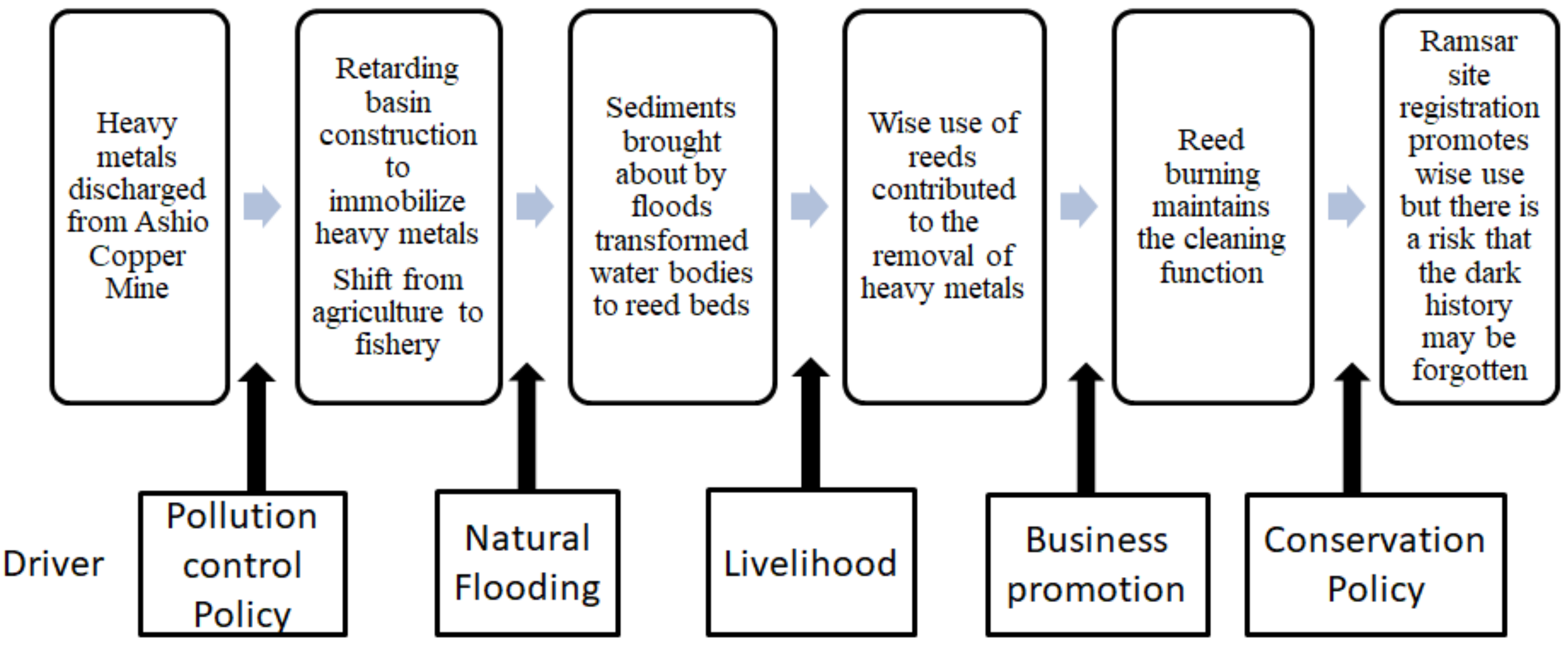
The history of the WRB is a direct result of the operations of the Ashio Copper Mine more than 100 years ago. Wastewater from the mine containing both heavy metals and high levels of sulfides was dumped into the Watarase River, along with the residual waste material from the ore extraction process. In 1903, the government determined that a retarding basin or catchment area be constructed to prevent the contaminated river water from moving further downstream to reach the capital city. The basin was proposed for the region between Ashio and Tokyo, with Yanaka Village ultimately identified as the appropriate site for constructing this basin [9].
Following this decision, Yanaka Village was abandoned in 1906, along with rice cultivation in the area designated for construction of the retarding basin. As a result, paddy fields became ponds with water depths ranging from 0.3 m to 1 m. Natural and converted ponds inside the retarding basin allowed villagers who had lost their farmlands but had not left their homes to make a living from fisheries. Although fisheries-dependent livelihood in a heavy metal contaminated site was questionable and risky, this period of fishery production lasted approximately two decades [8,9]. There were no records about food poisoning due to the consumption of fish unloaded from the ponds within the WRB. A possible explanation is that heavy metals were adsorbed to sediments and the settling of suspended sediments removed heavy metals from water column in a pond because flow velocity is often very low in a pond, allowing sediments to settle down to the bed. Besides, a study on bioaccumulation of heavy metals in fish tissues found muscles, which are the edible part of fish, always possessed the lowest concentrations of all metals [10]. Another study revealed that the bioaccumulation of mercury was higher in black bass than common carp [11]. Overall, metal bioaccumulation by fish and subsequent distribution in organs is dependent on many factors including species, sex, age, size, reproductive cycle, swimming patterns, feeding behavior and geographical location [12]. Therefore, although mercury accumulation in fish poses well-known health risks to humans, fish mercury levels can be highly variable, which may be considered another reason that fisheries in the WRB did not cause secondary disaster. The fishery inside the contaminated WRB is questionable and would be prohibited today. However, it was probably very difficult to discuss health risk 100 years ago due to the lack of sufficient scientific evidence and social awareness of health risk. Therefore, the fishery in the WRB might be wrong but it is hard to blame the fishermen and should be considered the limitation of time. Nevertheless, such a lesson should be learned and remembered to avoid the repetition of similar mistakes. In this regard, more environmental history studies on the WRB using modern technologies should be conducted, which will definitely lead to better understanding on the merits and demerits of constructing the WRB and the livelihood in it.
Around the end of the 1920s, sediments brought about by flooding accumulated in the retarding basin and turned most water bodies to wetlands. At this time, the natural seed bank resulted in the growth of a vast mass of reeds. Consequently, local people who had relied upon fisheries for the previous two decades started to make their living through sedge-hat and reed-curtain production. In the 1950s, the production of reed-curtains became mechanized, with the products used not only in households but also in Shiitake mushroom cultivation and sericulture operations. Reed-curtain production peaked in the 1970s with approximately 500,000 pieces made per year [13]. The market price of reed-curtains at that time was 3000–5000 yen per piece (equivalent to 12,000–20,000 JPY or 100–180 USD at present), resulting in sizable profits, and more than 200 families were involved in the production [14,15]. From the 1980s onwards, the production of reed-products fell due to the import of reed-curtains from China, with only approximately 70,000 pieces made in 1990 [16]. Besides, until some decades ago, reeds were also used in roof-making to some extent in Japan, but it was abandoned due to the change of life style. Today, the making of reed-curtains and other reed products in the WRB has ceased altogether.
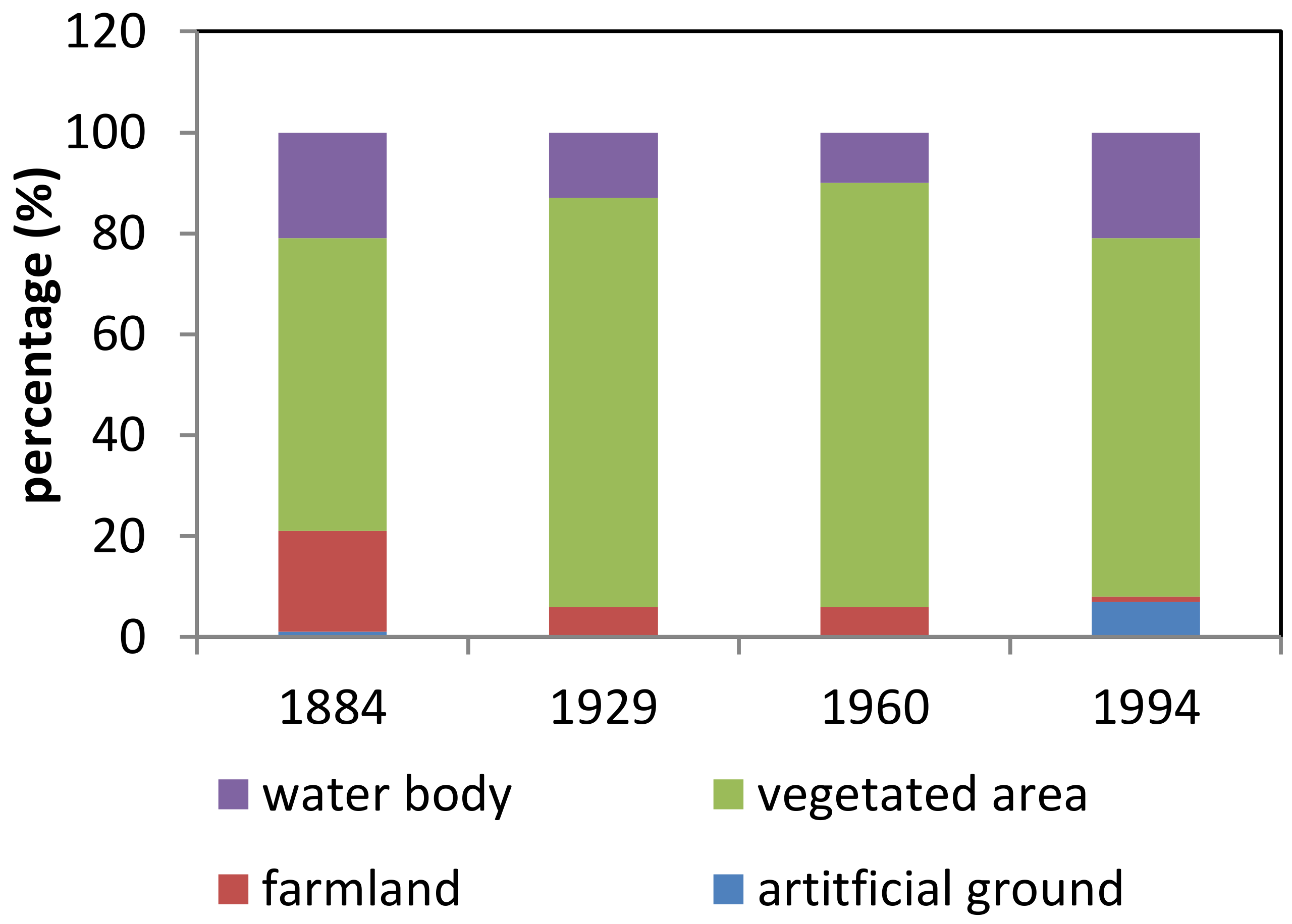
The changes in land use in the WRB are shown in Figure 2. The recovery of water surface area in the 1990s was due to the construction of Lake Yanaka. The increase in artificial ground is due to the construction of a sports ground and parks.
In the 1950s, to grow reeds of a high enough quality for production purposes and for reasons of pest control, reed burning was initiated. However, as the reed business decayed, the cost of reed burning became a barrier to the continuation of this practice. Further pressure to halt this practice came from the residents of newly developed residential areas near the retarding basin, who complained about the bad air quality due to the burning. However, in view of the benefits of reed burning in maintaining the quality of the reed marsh and promoting new growth of rare plant species, the management office of the Watarase River started to support the practice and, since 2000, aid reed burning in the WRB.
Since the WRB achieved Ramsar status in 2012, owing to being a place for the preservation of many endangered and endemic species, it has been viewed as an “Eco-Museum” by the general public, with the number of visitors increasing in recent years. Around half of the visitors to the WRB are local people, with another half visiting the wetland for leisure activities such as cycling or for receiving environmental education by high school students according to our interview with the staff in the Watarase Museum. This implies that visitors spend very little money in utilizing the wetland. In addition, there are no hotels inside or near the wetland, and only a few restaurants within walking distance. Furthermore, it takes about 20 min from the nearest train station to the WRB. The WRB therefore generates very little in the way of revenue from leisure and tourism due mainly to the insufficiency of attraction and poor public transport infrastructure.
Our on-site questionnaire surveys revealed that 54% of non-local visitors and 43% of the local visitors interviewed believed the environment of the wetland to be good. None of the non-local and only 7% of the local visitors considered the environment to be bad. The most astonishing difference between local and non-local visitor perceptions is that 93% of local visitors had some knowledge of the Ashio Copper Mine problem while 78% of non-local visitors had no knowledge of the history of the wetland. Non-local visitors tend to come to the WRB because it is a registered Ramsar site. When asked whether there are heavy metal residues in the wetland, one third of local visitors considered that no residues remain, one third did not know and the remaining third considered that there were residues present. When non-local visitors were asked the same question, 23% considered that no residues remain, while 61% did not know and the remaining 16% believed that there are still heavy metal residues in the wetland. These results revealed that the information on the wetland to the public, especially to the non-local, is somewhat biased by the registration of the wetland as a Ramsar site. As a result, the public perception towards the current environmental condition of the wetland is clouded.
In off-site questionnaire surveys, amongst students of the Graduate School of Global Environmental Studies, Sophia University, 77% of those asked were aware of the WRB wetland but 62% were unaware of the Ashio Copper Mine problem, even though they are majoring in environmental studies. These survey results suggest that environmental education on the history of the WRB wetland is fragmented and far from sufficient. This situation may also be attributed to the quality of information related to the WRB. Young graduate students majored in environmental studies are supposed to become environmental management leaders in the near future. If our future environmental leaders do not possess the sound and deep understanding of major pollution cases in the past, how can they be expected to perform their duty of protecting the environment in scientifically sound ways? Education for Sustainable Development (ESD) is about learning what is needed to maintain and improve our quality of life and the quality of life of generations to come. Therefore, profound knowledge on drivers that may trigger major environmental and societal changes should be a main focus of ESD and should be obtained through both in-class teaching and field-based learning.

3.2. Environmental Perspective

Despite the huge impact of pollution on society and the environment, historic data regarding heavy metals in the soil of the WRB are limited, with a lack of accurate information on specific sampling sites. The work done by Kozai [17] indicated that the concentration of soluble Cu in affected areas ranges from 220 to 530 ppm. According to a non-profit organization, the top soil in the abandoned Yanaka Village contained concentrations of Cu of 380 ppm in 1980 [18]. Another survey conducted at two locations within Yanaka Village in 2014 reported concentrations of soluble Cu of 105 and 219 ppm, respectively [19].
Concentrations of heavy metals across the sampling sites obtained by our investigation were in the following ranges: Pb, 37–167 mg/kg; Cd, 0.12–13.3 mg/kg; Cu, 21.3–150.2 mg/kg; and Cr6+, 2.1–32.6 mg/kg. The levels of Cd, Cu and Cr obtained in this study were lower than the environmental standards of Japan [20] at all sampling sites. For Pb, the environmental standard for soil is 150 mg/kg. One sample exceeded this limit and approximately 30% of samples contained concentrations higher than 100 mg/kg. Considered in the context of the historical data, the concentration of soluble Cu measured in this survey indicates the possibility that the removal rate of Cu has been accelerated in recent years.
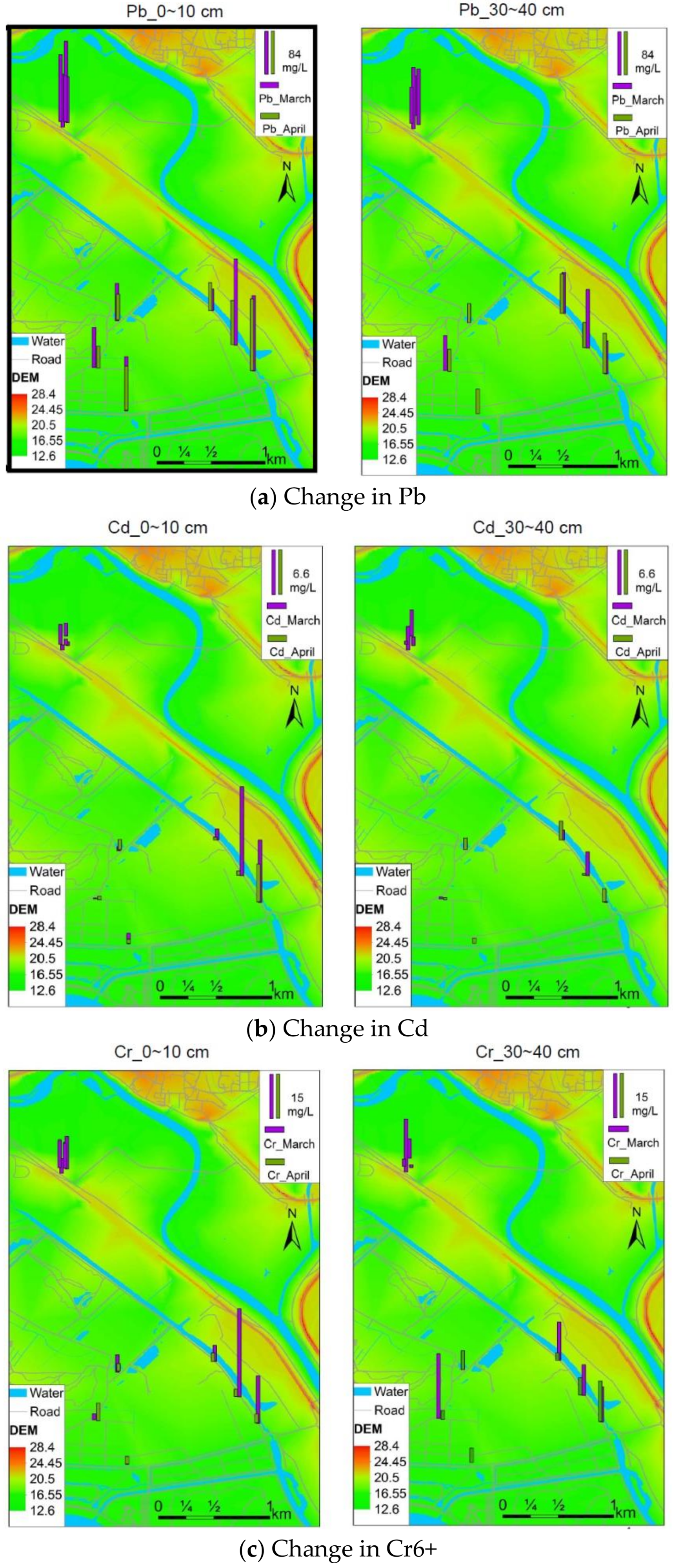
In 2018, reed burning was carried out on 17 March. The concentrations of heavy metals in the soil before and after the reed burning are shown in Figure 3a–c.
In Figure 3, heavy metal concentrations were higher in the eastern and northern sides of the survey area than in the western and southern sides. This distribution is attributable to flooding, since flood waters flow into the retarding basin from the northeast, where an overflow spillway is located. The reeds reduce the flow velocity of flood waters and enhance sediment deposition. Heavy metals in the sediment are trapped by the reeds, leading to reduction of heavy metals in soil in the downstream direction, where Lake Yanaka is located. Considering the fact that the lake has the function of providing drinking water to residents downstream, the reeds provide an important cleaning function. It can also be observed in Figure 3a–c that concentrations of heavy metals decreased after burning. Average concentrations before and after burning were 94.2 mg/kg and 65.6 mg/kg for Pb, 2.3 mg/kg and 1.4 mg/kg for Cd, and 9.6 mg/kg and 5.4 mg/kg for Cr6+, respectively. It is seen that the reduction in heavy metal concentration through reed burning is greater for Pb than Cd and Cr6+. Utilization of the Mann–Whitney U test indicated that these differences are statistically significant (p < 0.05). It was also found that pH values had insignificant change before and after the burning but the average temperature of top soil increased from 10.8 to 25.6 °C. Burning of the reeds removes the old plants and promotes regrowth, which maintains the capacity of the reeds to trap heavy metals from the soil. Conventional in-situ soil remediation techniques include soil washing/leaching/flushing with chemical agents, chemical immobilization/stabilization by adding non-toxic materials into the soils, electrokinetic remediation, replacing or mixing the polluted soil with clean soils to reduce the concentration of heavy metals and phytoremediation using plants. The mechanism of reduction of heavy metals in soil via setting a large-scale fire on a contaminated land to enhance phytoremediation has never been reported before according to the author’s literature survey. Therefore, the present study serves as a call for further study on this removal process in relation to phytoremediation. Nevertheless, the burning of reeds may cause air pollution and discomfort to the local residents. Therefore, further study should also include the assessment of the negative aspects of reed burning and search for mitigation measures if any negative aspect is confirmed.
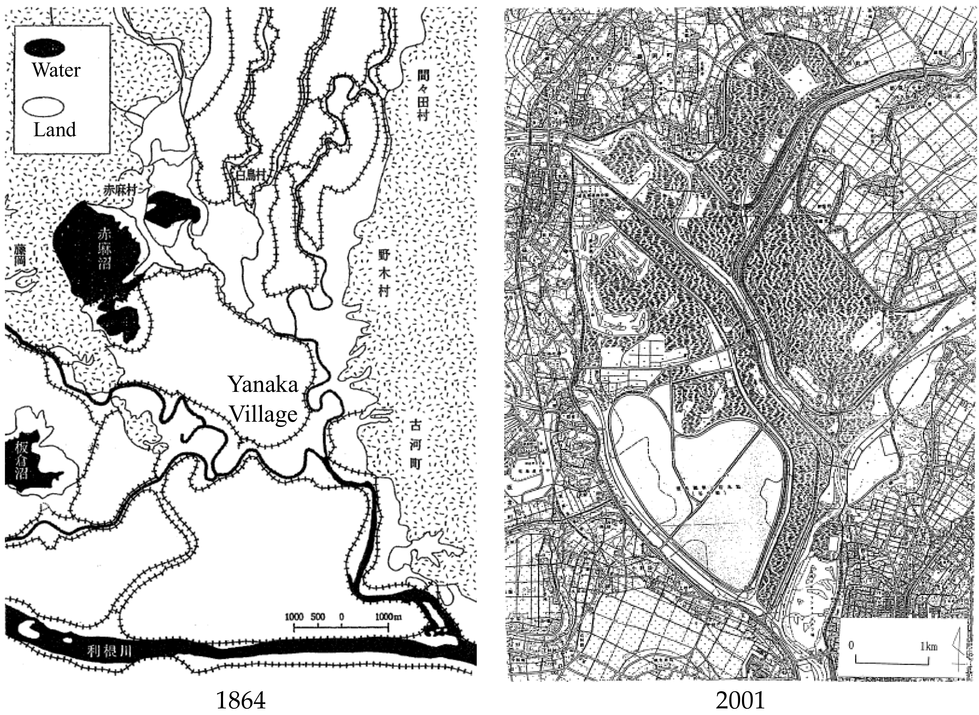
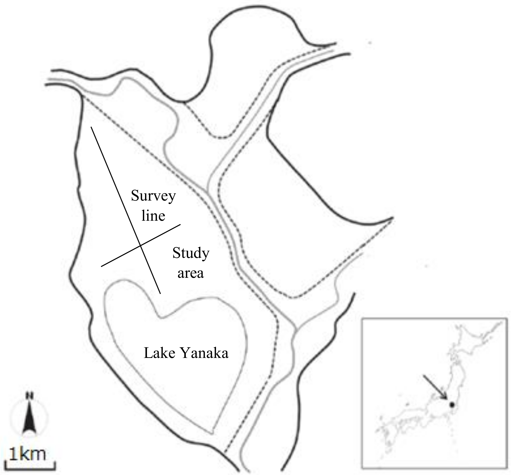
As shown in 
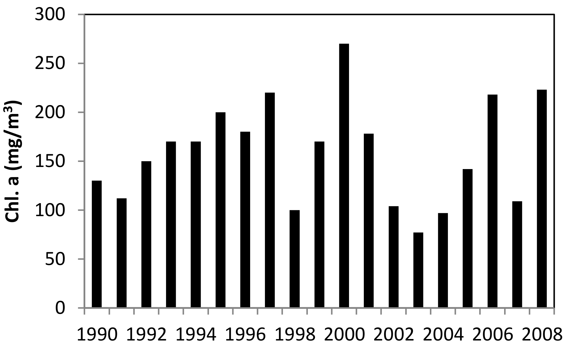
Figure 4, in the 19th century, there were a number of lakes in the northern part of the retarding basin. They disappeared in the 1990s. Instead, a lake, named as Yanaka, was constructed in a heart shape in 1989 for flood regulation, drinking water supply and maintenance water supply to the downstream rivers. It has a surface area of 4.5 km
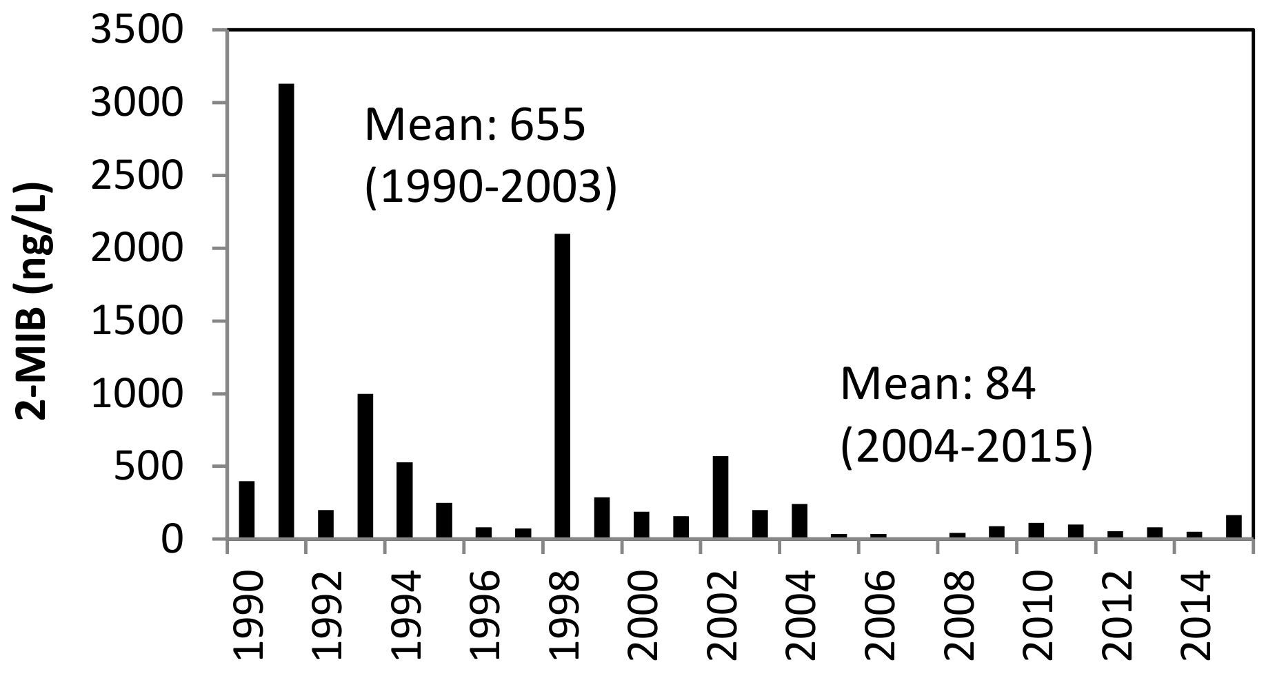
2 and an average depth of six meters with seasonal changes of about three meters. However, the lake became eutrophic quickly in the 1990s due to excessive nutrients input mainly from the Yata River. The annual peak concentration of chlorophyll a in the lake ranged from 110 to 270 µg/L in the 1990s. Consequently, the lake suffered from the musty odor problem (2-MIB), affecting the tap water quality in areas where the water from the lake was supplied. The excessive growth of Phormidium was identified as the cause of 2-MIB [21] and a countermeasure was taken by the lake’s administration office, which was drawing down the water level [22]. Since 2004, ever year the water in the lake is pumped out and 80% of the lake bed is exposed to air for one and half months between January and March. As shown in Figure 5, this water level drawdown operation results in bed desiccation, significantly decreasing the concentration of 2-MIB in the lake. The study by Kajiyama et al. [23] indicated that bed desiccation operation significantly reduced the cell number of Phormidium in the lake. However, the relationship between the level of 2-MIB and the cell number of 
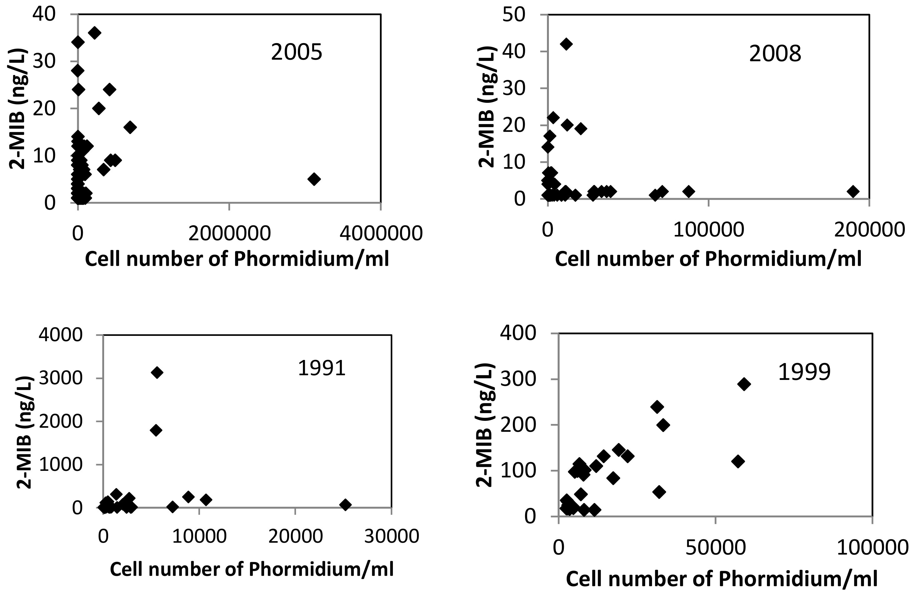
Phormidium is still poorly understood. Data scrutiny revealed that the relationship between the level of 2-MIB and the cell number of Phormidium is complicated. As shown in Figure 6, the relationship between the two on annual basis before and after the drawdown countermeasure varied greatly from year to year. Except 1999, a common feature to all annual variations is that the highest cell number of Phormidium did not correspond to the highest level of 2-MIB. A further look into the data found that a significant difference between the two periods is that the cell number of Phormidium at the time of annual maximum 2-MIB ranged 400–900,000/mL before the drawdown while it ranged 7000–110,000/mL afterwards. In 1991, the cell number of Phormidium was 5630/mL when 2-MIB reached to its highest ever value, 3130 ng/L. This observation led to a hypothesis that the water level drawdown delayed the growth of Phormidium, which resulted in less release of 2-MIB from the cells of Phormidium. The relationship between 2-MIB and water temperature was also examined and correlation was not found. It should also be pointed out here that 2-MIB was still present in the lake after the drawdown and there were days when the level of 2-MIB exceeded Japan’s environmental standard for 2-MIB although the level was significantly lower than that before the start of drawdown. The standard of 2-MIB in public waters is 10 ng/L in Japan. Although the smell in water leads to frequent complaints from consumers, 2-MIB-related health risk or cytotoxicity has been very much undocumented thus far. Besides, as shown in Figure 7, the annual peak concentration of chlorophyll a in the lake was not reduced by the drawdown operation. Therefore, further study is needed to better understand the mechanism of odor generation and its health risk, better quantify the effectiveness of water level drawdown operation in dealing with the problem and better manage the eutrophication process of the lake.
It should also be mentioned here that there has not been any large-scale coordinated investigation on the soil and water environment downstream of the WRB to evaluate the effectiveness of the WRB in stopping the contamination since its construction. The fact that there have been no complaints from the communities downstream of the WRB on heavy contamination is considered as good evidence of effective control of heavy metals by the WRB. A study on the distribution of heavy metals in the bottom sediment of the Watarase River showed that concentrations of heavy metals decreased very significantly from upstream to downstream before it joins the Tone River [26]. Although more than 100 years elapsed, an in-depth re-visit to the effectiveness of the WRB to control the pollution is worth conducting.

4. Conclusions

The environmental changes that have taken place in the area of the WRB, and the associated drivers for these changes, are presented in Figure 8. After the mining-caused pollution due to the operation of the Ashio Copper Mine was revealed, the policy of preventing toxic heavy metals from being transported further downstream towards more populated regions led to the construction of the Watarase Retarding Basin. Creating the WRB in turn transformed paddy fields to ponds. This change in the landscape drove those villagers who had lost their farmlands but were able to remain in their homes to make their living from newly created fisheries. As sediments brought about by flooding accumulated in the retarding basin, ponds were gradually converted to reed beds. Local livelihoods were shifted again, this time from fisheries to the making of reed-based products. Utilizing the reeds in this way directly contributed to the removal of heavy metals from the soil and can be considered as a primitive form of phytoremediation. The burning of reeds to maintain the growth of good quality reeds maintains the wetland’s capacity for removing heavy metals from the soil. In other words, the wise use of wetland resources contributed to the environmental improvement of the WRB. In 2012, the registration of the WRB as a Ramsar site served as a new driver for better and more integrative management of the wetland. Ecotourism in the WRB is now gaining momentum and many tourists come to see the large-scale reed wetland; the burning of reeds is an especially big attraction. However, ecotourism in the wetland has made little contribution to the local economy.
The investigation of heavy metals residues in the WRB found that the burning of reeds led to a reduction in the concentrations of heavy metals in the soil. One explanation for this is that the burning process promotes seed germination and healthy reeds absorb heavy metals during their growing period. During the 1950s, the reed burning contributed to both the expanding reed-product business, by supporting good quality reed growth, and the removal of heavy metals from the soil. Today, reed burning contributes to ecotourism, supports biodiversity and continues to remove heavy metals from the soil. Therefore, reed burning can be considered as good wetland management practice, although it may have some negative effects on air quality in surrounding areas.
A new issue occurred in the 1990s: the quick deterioration of water quality in the newly constructed Lake Yanaka. A countermeasure was found to be effective in controlling algae-caused odor problem, although it was not completely solved.
Another issue identified by the present study is that the registration of the wetland as a Ramsar site has guided the general public to access the information the wetland in certain direction that led to a fragmented knowledge structure of the general public that has an adverse effect on the comprehension of the history and the current environmental condition of the wetland by the general public.
A comprehensive study integrating soil, vegetation, water and the public perception, therefore, should be pursued to seek an integrated pathway to the sustainability of the wetland in the context of regional environmental management and public involvement. Such a study should also address issues such as the promotion of ecotourism and the long-term prediction on the movement of heavy metal residues in soils, vegetation and waters within the WRB and the potential risk of being transported outside.
Overall, this paper presents a case in which a contaminated site was transformed to a conservation site through the implementation of two polices chosen by the government: (1) policy to confine heavy metals; and (2) policy to conserve the wetland using the Ramsar Convention, and the wise use of natural resources by locals. The pollution control policy can be justified in terms of stopping further movement of heavy metals, however, it did seriously affect the livelihood of people in the WRB. The latest policy to register the wetland as a Ramsar site is effective in maintaining the reed beds and attracting visitors, but it might mask the dark history of the WRB, as the survey results revealed. The whole story, from its adverse beginnings to the present value of the WRB and the problems still faced with, should be communicated to the next generation without any bias and segmentation. Research initiatives with such a long-time scale and cross-sectoral approach will enrich the literature of sustainability studies and contribute to coping with various persistent environmental problems.

Author Contributions

G.H. designed this study, carried out field surveys and water and soil quality analyses with co-authors, and drafted the manuscript. Y.F. was responsible for questionnaire surveys. H.X. and H.L. contributed to soil quality analysis.

Funding

This research was part of Sophia Research Branding Project 2016 and funded by the Ministry of Education, Culture, Sports, Science and Technology, Japan.

Acknowledgments

Thanks are given to anonymous reviewers and handling editor for their professional comments and suggestions which improved the quality of this paper.

Conflicts of Interest

The authors declare no conflict of interest.

References

  1. Nash, R.; Nash, R.F. Wilderness and the American Mind; Yale University Press: New Haven, CT, USA, 2001. [Google Scholar]
  2. Oceans Past Initiative. Available online: http://oceanspast.org/ (accessed on 15 October 2018).
  3. Ui, J. Industrial Pollution in Japan; United Nations University Press: Tokyo, Japan, 1992. [Google Scholar]
  4. Morinaga, E. Asho Mine Pollution; Nippon Hyoron Sha, Publishers: Tokyo, Japan, 1982. (In Japanese) [Google Scholar]
  5. Arahata, K. The extinction of Yanaka Village; Iwanami Shoten, Publishers: Tokyo, Japan, 1999. (In Japanese) [Google Scholar]
  6. Ooshika, T.; Ishimune, M. The Record of a Wild Person—The Legend of Tanaka Shozo; Shinsensha Co., Ltd.: Tokyo, Japan, 2009. (In Japanese) [Google Scholar]
  7. Miyake, S.; Hasegawa, H.; Nakanoh, M. Investigation on heavy metals in Watarase River Basin. Bull. Tochigi Pref. Agric. Exp. Stn. 1975, 20, 35–54. (In Japanese) [Google Scholar]
  8. Ohmichi, K.; Seno, Y.; Takahashi, A.; Kojima, K.; Miyamoto, H.; Ohmichi, M.; Matsuki, Y.; Machida, K. Recent heavy metal concentrations in Watarase Basin around Ashio Mine. J. Health Sci. 2006, 52, 465–468. [Google Scholar] [CrossRef]
  9. Tokairin, K.; Sugamasu, E. History-Ashio Mineral Poison Case 1877~1984; Shinyosya: Tokyo, Japan, 1984. (In Japanese) [Google Scholar]
  10. El-Moselhy, K.M.; Othman, A.I.; El-Azem, H. Abd; El-Metwally, M.E.A. Bioaccumulation of heavy metals in some tissues of fish in the Red Sea, Egypt. Egypt. J. Basic Appl. Sci. 2014, 1, 97–105. [Google Scholar] [CrossRef]
  11. Zhou, H.Y.; Wong, M.H. Mercury accumulation in freshwater fish with emphasis on the dietary influence. Water Res. 2000, 34, 4234–4242. [Google Scholar] [CrossRef]
  12. Mustafa, C.; Guluzar, A. The relationships between heavy metal (Cd, Cr, Cu, Fe, Pb, Zn) levels and the size of six Mediterranean fish species. Environ. Pollut. 2003, 121, 129–136. [Google Scholar]
  13. Fujioka Town History Compiling Committee. Fujioka-Machi History: Documents-Yanaka Village; 13, Fujioka Town Office: Fujioka Town, Tochigi City, Tochigi Prefecture, Japan, 2001. (In Japanese) [Google Scholar]
  14. Watarase Retarding Basin Memorial 100 Executive Committee. Watarase Retarding Basin Memorial 100: From Yanaka Village Ruins to the Future of Watarase Retarding Basin; Fujioka Town Office: Fujioka Town, Tochigi City, Tochigi Prefecture, Japan, 2007. (In Japanese) [Google Scholar]
  15. Kumakura, Y. Geographical Study of Yoshizu Manufacturing Industry in the Area around Lake Akama; Fujioka-Machi Library: Tochigi-shi, Japan, 1977. (In Japanese) [Google Scholar]
  16. Fujioka Town History Compiling Committee. Fujioka-Machi History: Second Part; Fujioka Town Office: Fujioka Town, Tochigi City, Tochigi Prefecture, Japan, 2004. (In Japanese) [Google Scholar]
  17. Kozai, Y. Study on the contamination due to Ashio Copper Mine. Bull. Chem. Soc. Tokyo 1892, 13, 143–200. (In Japanese) [Google Scholar]
  18. (NPO) Grow Green in Ashio. Rebirth of Ashio’s Green; Zuisousha Co., Ltd.: Tochiki, Japan, 2001. [Google Scholar]
  19. Kumazawa, K. A group of agricultural scientists related to the Ashio Copper Mine incident. Fertilizer Sci. 2015, 37, 1–73. (In Japanese) [Google Scholar]
  20. Japanese Environmental Standards for the Contents of Heavy Metals in Soils. Available online: http://www.mlit.go.jp/sogoseisaku/region/recycle/pdf/fukusanbutsu/kensetsuodei/odei_file1-6-8.pdf (accessed on 15 October 2018).
  21. Sugiura, N.; Utsumi, M.; Wei, B.; Iwami, N.; Okano, K.; Kawauchi, Y.; Maekawa, T. Assessment for the complicated occurrence of nuisance odours from phytoplankton and environmental factors in a eutrophic lake. Lakes Reserv. 2004, 9, 195–201. [Google Scholar] [CrossRef]
  22. Satou, H.; Amamo, M. Influences of water level drawdown and bed-drying in a shallow reservoir on production of 2-methylisoborneol-A pioneering investigation in the Watarase Reservoir. Ecol. Civ. Eng. 2007, 10, 141–154. [Google Scholar] [CrossRef]
  23. Kajiyama, Y.; Saito, M.; Kato, H. Research on 2MIB Suppression Effect by Bed Desiccation; Annual Technical Report of Water Resources Environment Center; Water Resources Environment Center: Okayama, Japan, 2012; pp. 29–35. (In Japanese) [Google Scholar]
  24. Geospatial Information Authority of Japan. Geospatial Information Library. Available online: http://geolib.gsi.go.jp/node/2373 (accessed on 23 November 2018).
  25. Tone River Upstream River Office. Information on the Watarase Retarding Basin. Available online: http://www.ktr.mlit.go.jp/tonejo/tonejo_index006.html (accessed on 23 November 2018).
  26. Uchiyama, M.; Nakajima, Y.; Akaiwa, H. Distribution of heavy metals (trace chalophile elements) in the bottom sediment of the Watarase River. Jpn. J. Water Pollut. Res. 1984, 7, 555–560. [Google Scholar] [CrossRef]
Figure 1. Watarase Retarding Basin and the study area.
Sustainability 10 04385 g001
Figure 2. Land use change in the Watarase Retarding Basin.
Sustainability 10 04385 g002
Figure 3. Burning effect in reducing the concentrations of heavy metals.
Sustainability 10 04385 g003
Figure 4. Shift in water body from scattered ponds to a man-made lake within the WRB (Source: Geospatial Information Authority of Japan [24]).
Sustainability 10 04385 g004
Figure 5. Long-term variation of annual peak 2-MIB in Lake Yanaka (Source: Tone River Upstream River Office [25]).
Sustainability 10 04385 g005
Figure 6. Relationships between 2-MIB and Phormidium in different years (Source: Tone River Upstream River Office [25]).
Sustainability 10 04385 g006
Figure 7. Variation of yearly maximum chlorophyll a in Lake Yanaka (Source: Tone River Upstream River Office [25]).
Sustainability 10 04385 g007
Figure 8. Major changes and associated drivers in the Watarase Retarding basin.
Sustainability 10 04385 g008

