Analysis of the Dynamic Urban Expansion Based on Multi-Sourced Data from 1998 to 2013: A Case Study of Jiangsu Province


Abstract
:1. Introduction
2. Materials and Methods
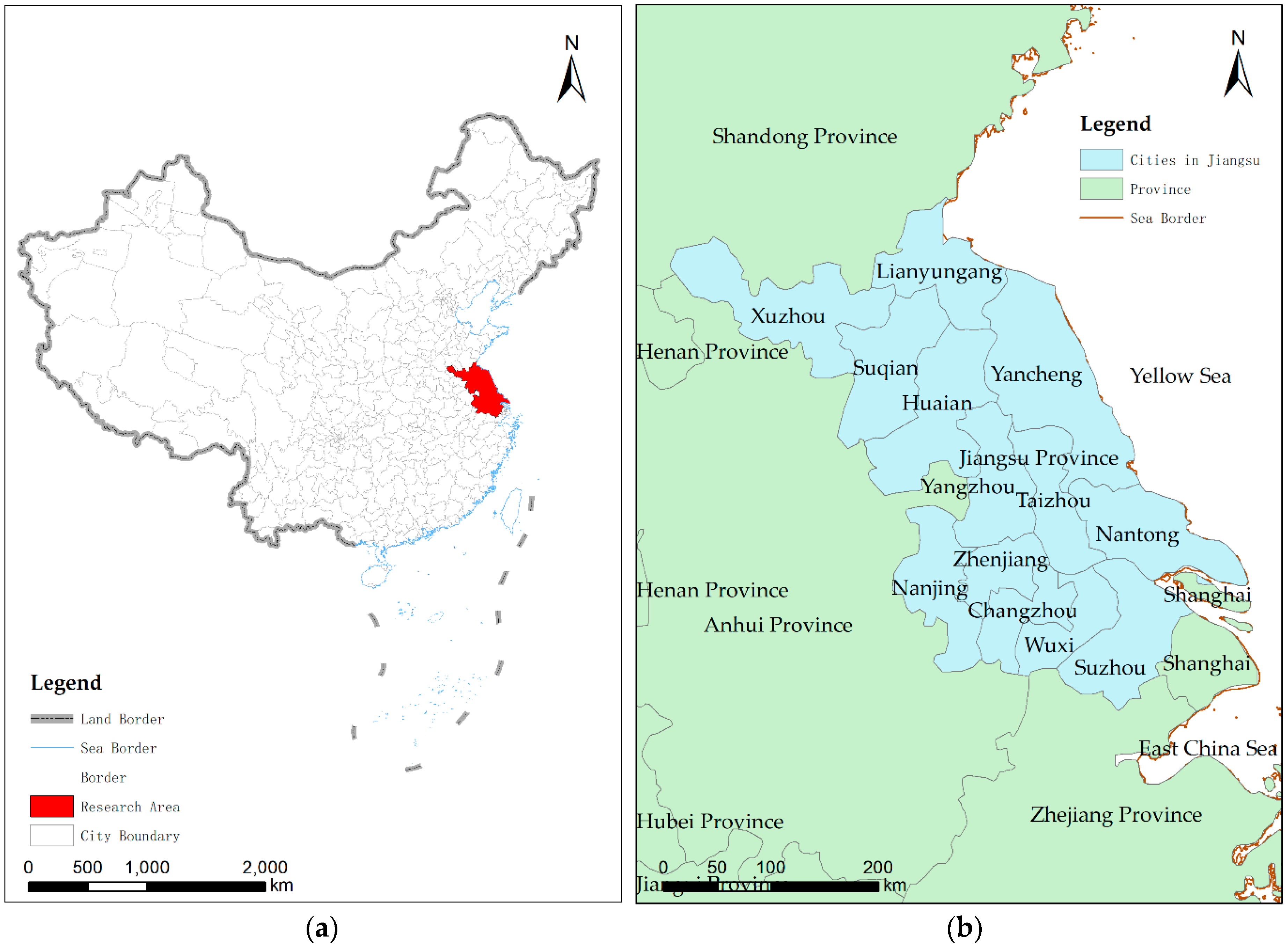
2.1. Study Area
2.2. Data and Preprocessing
2.3. Method
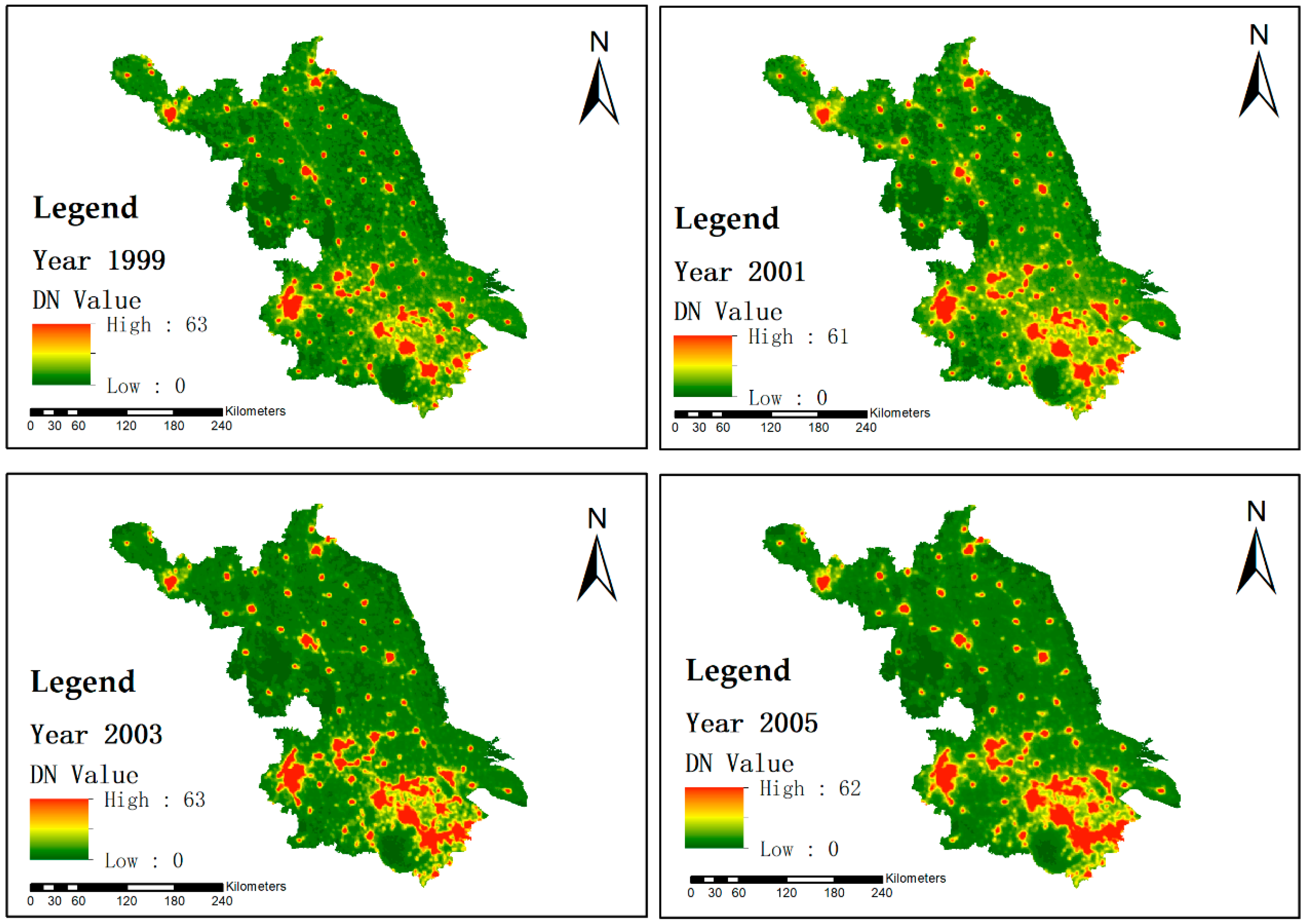
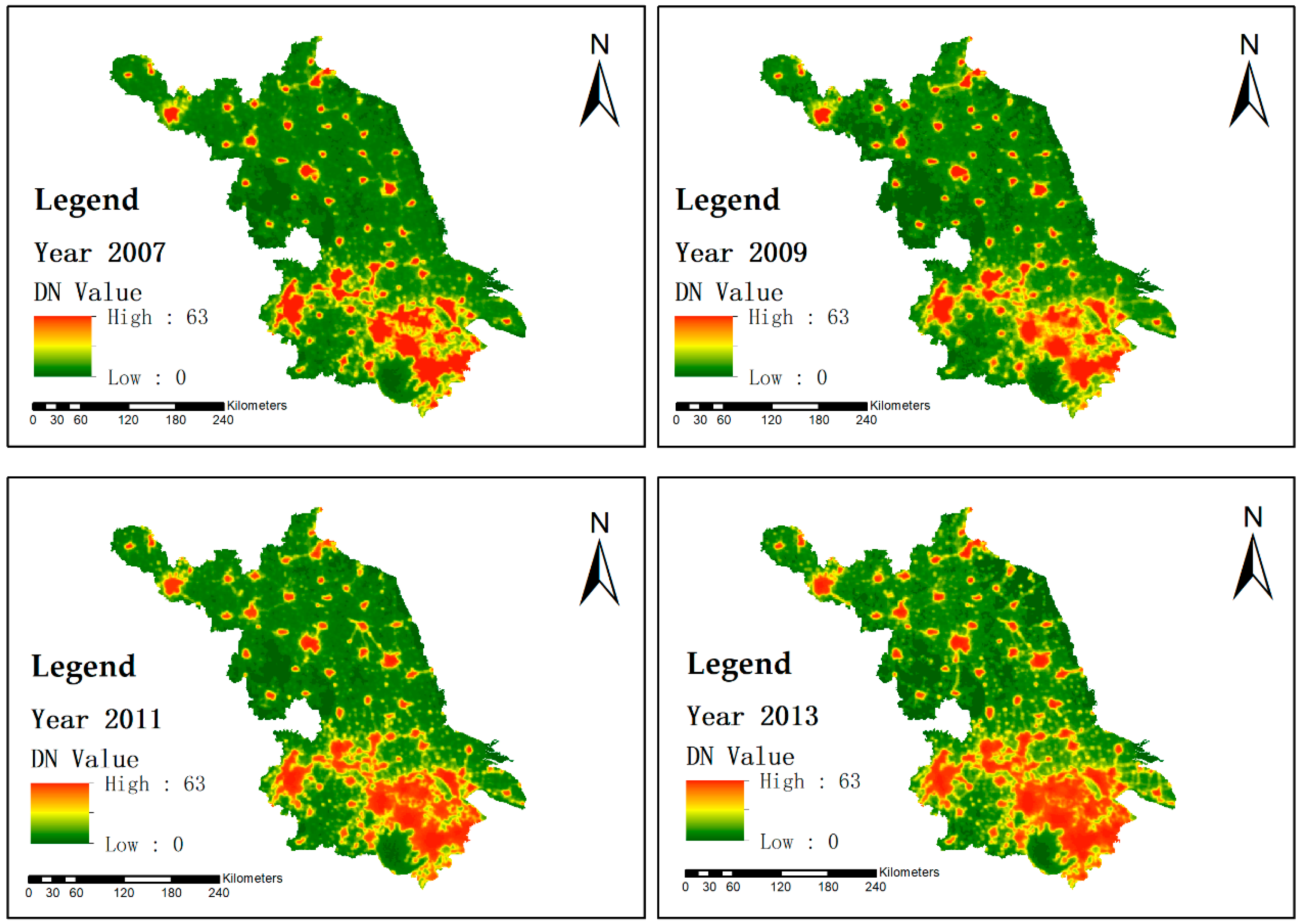
2.3.1. Urban Built-Up Area Extraction
2.3.2. Annual Urban Expansion Speed
2.3.3. Urbanization Intensity Index
2.3.4. Built-Up Area Gravity Center
3. Results
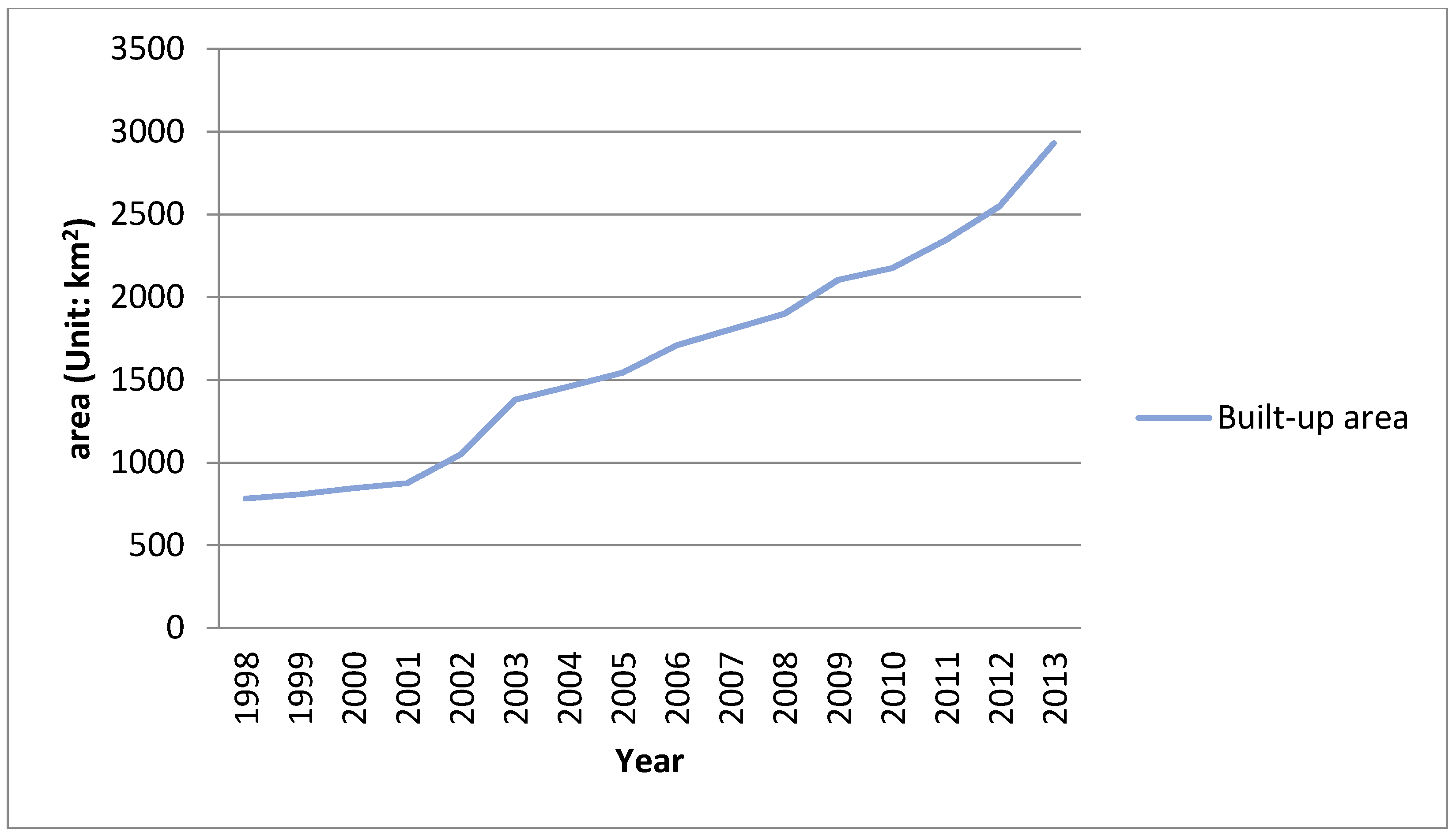
3.1. Urban Expansion for the Fifteen Years
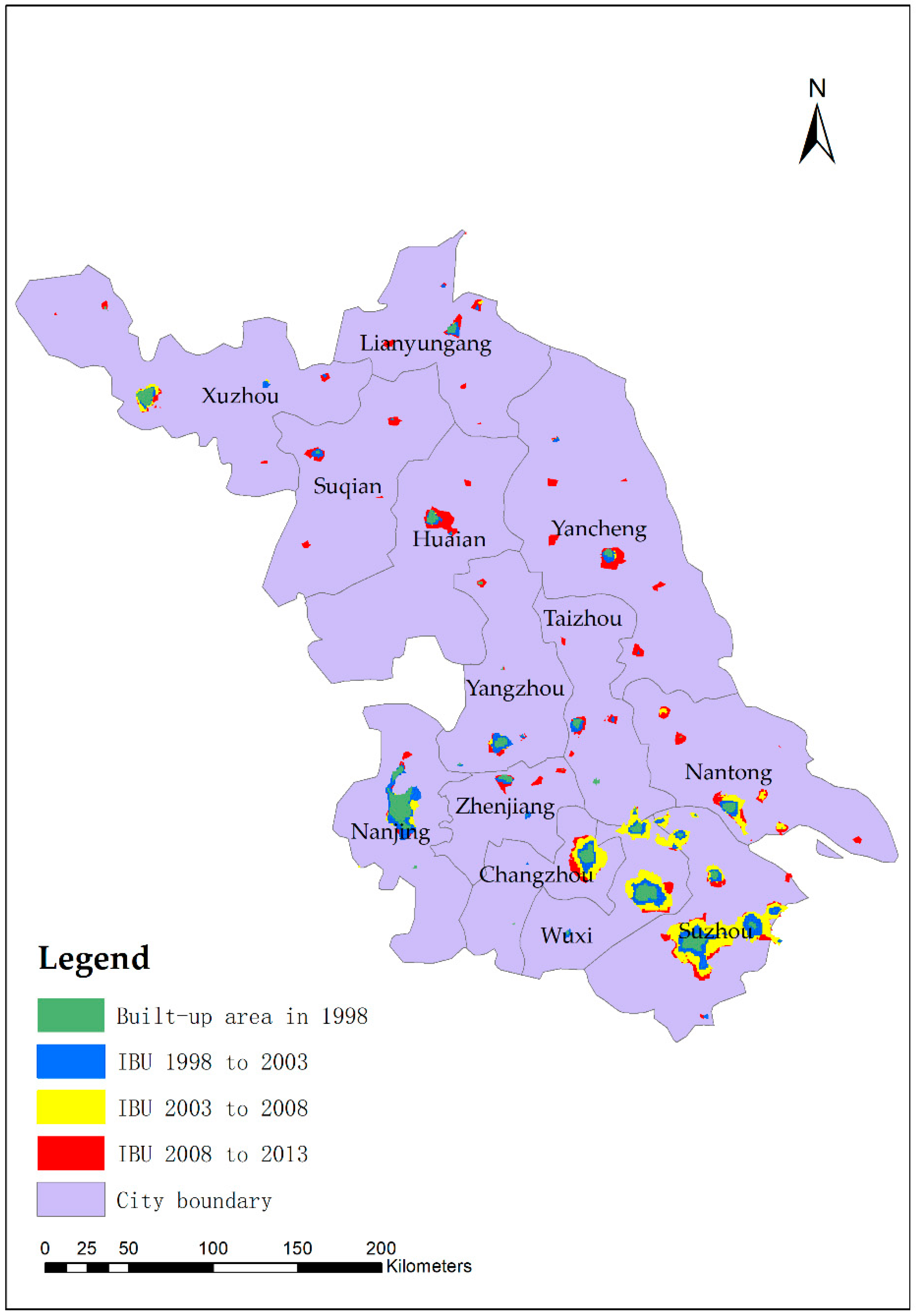
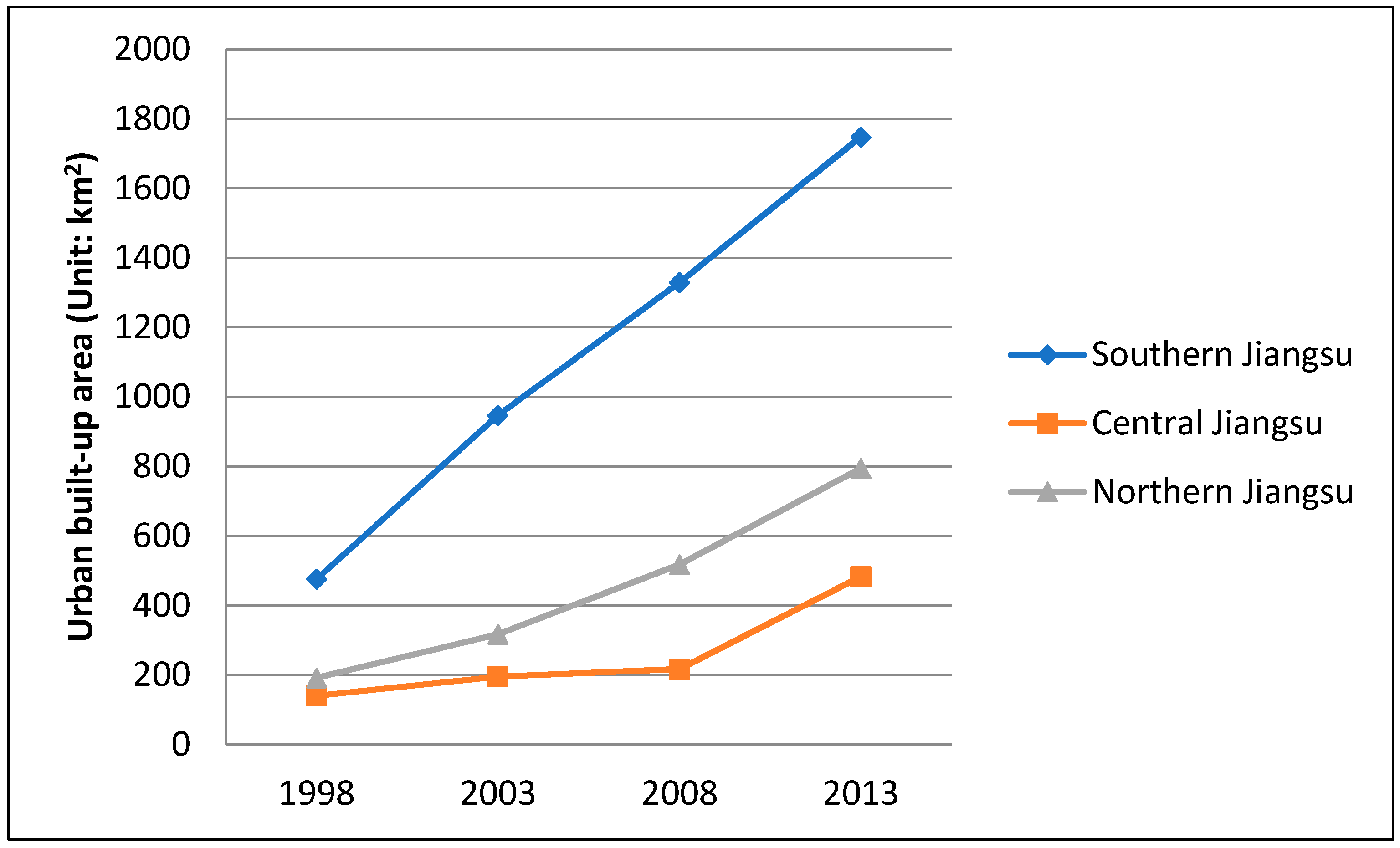
3.2. Spatio-Temporal Patterns of Urban Growth of Jiangsu Province
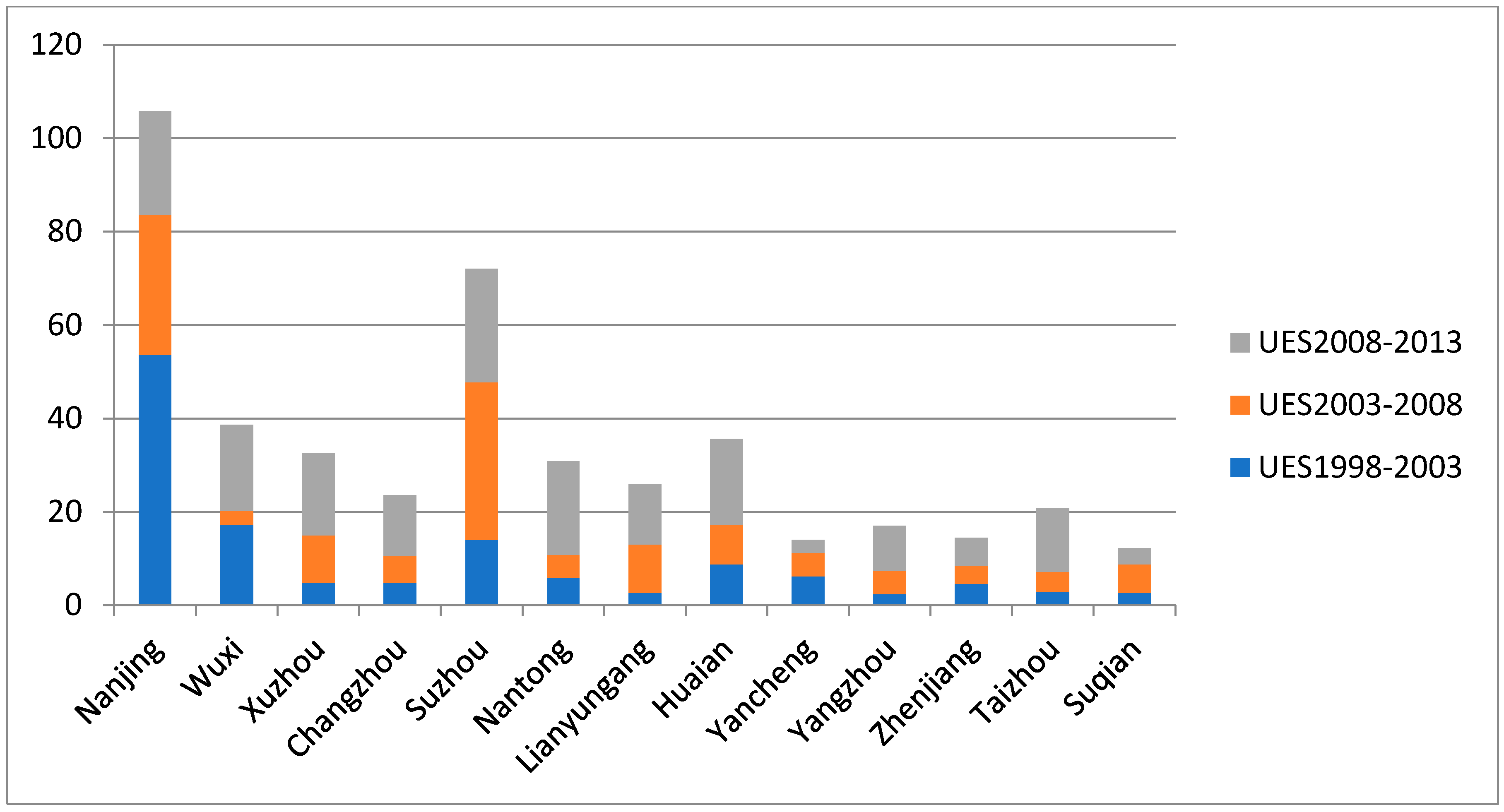
3.3. Urbanization Indices of Jiangsu Province
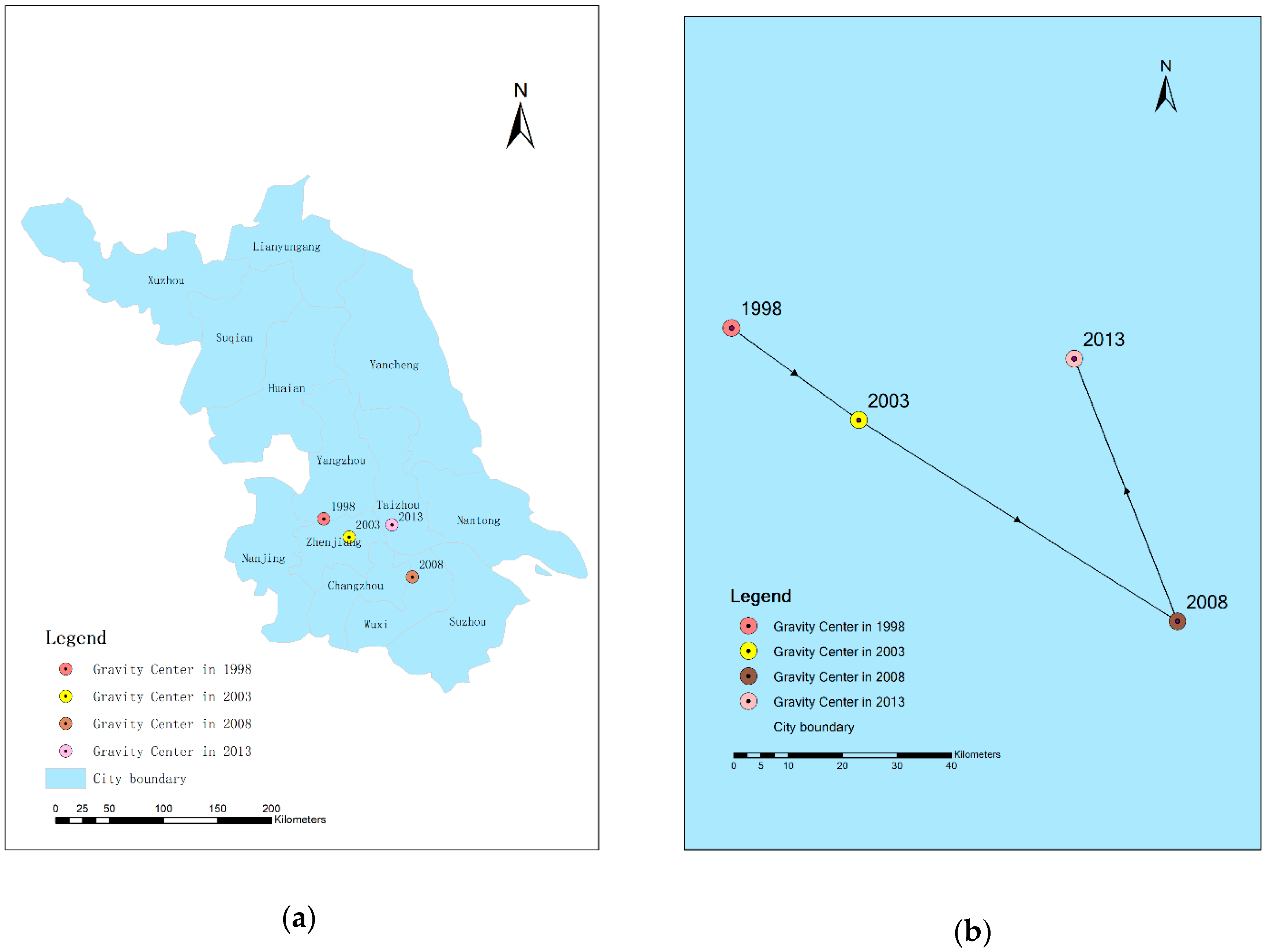
3.4. Urbanization Gravity Center Change of Jiangsu Province
4. Discussion
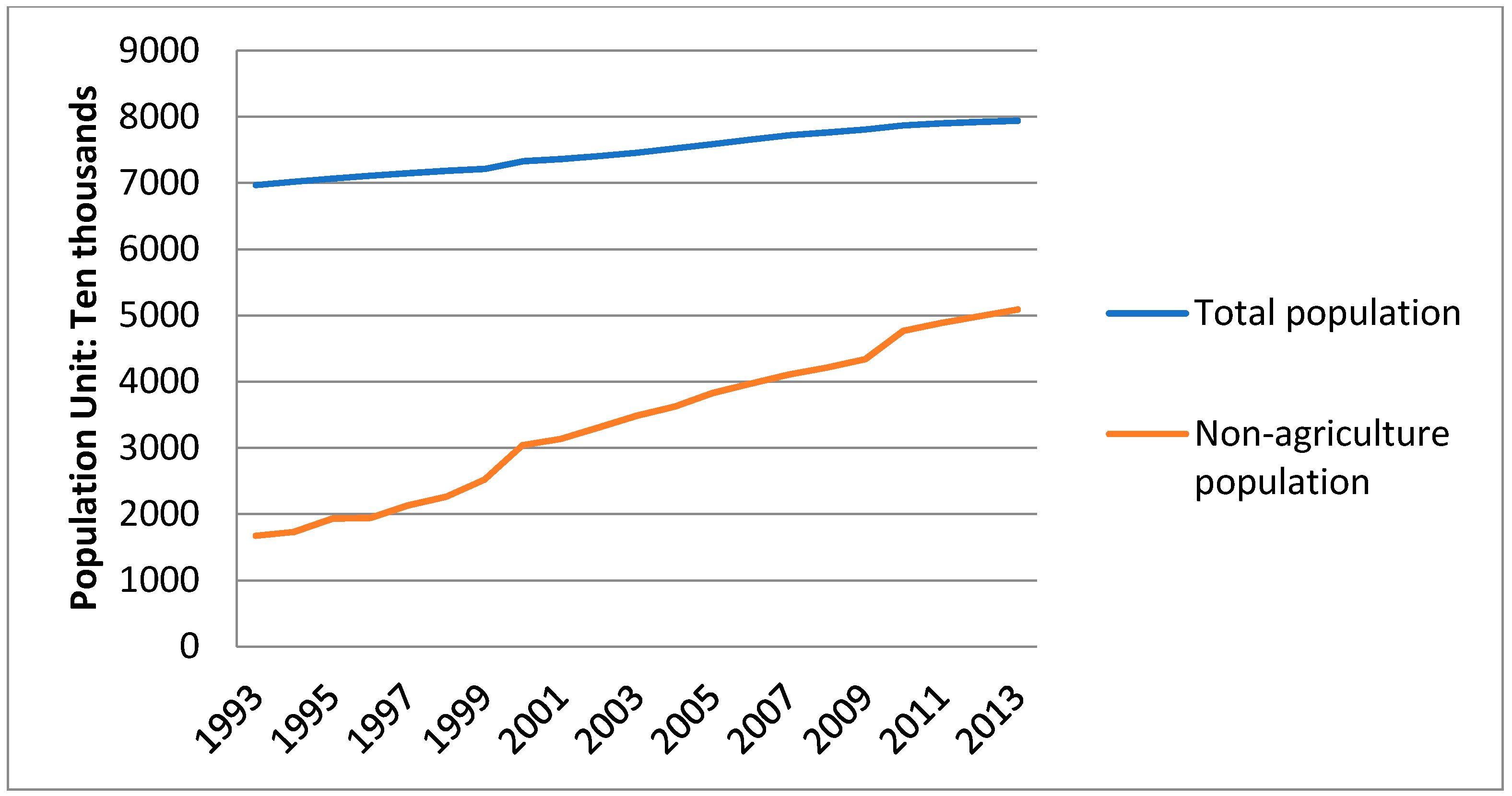
4.1. Rapid Population Growth
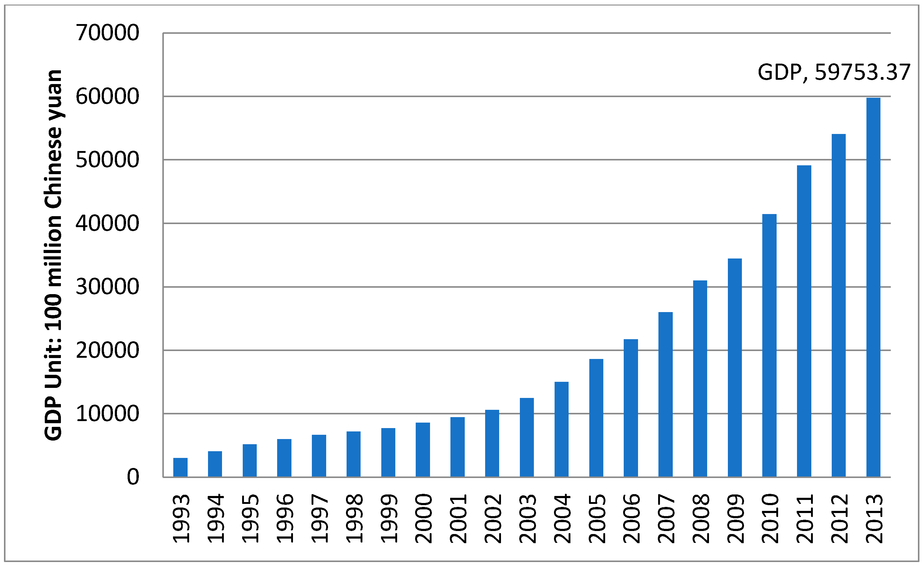
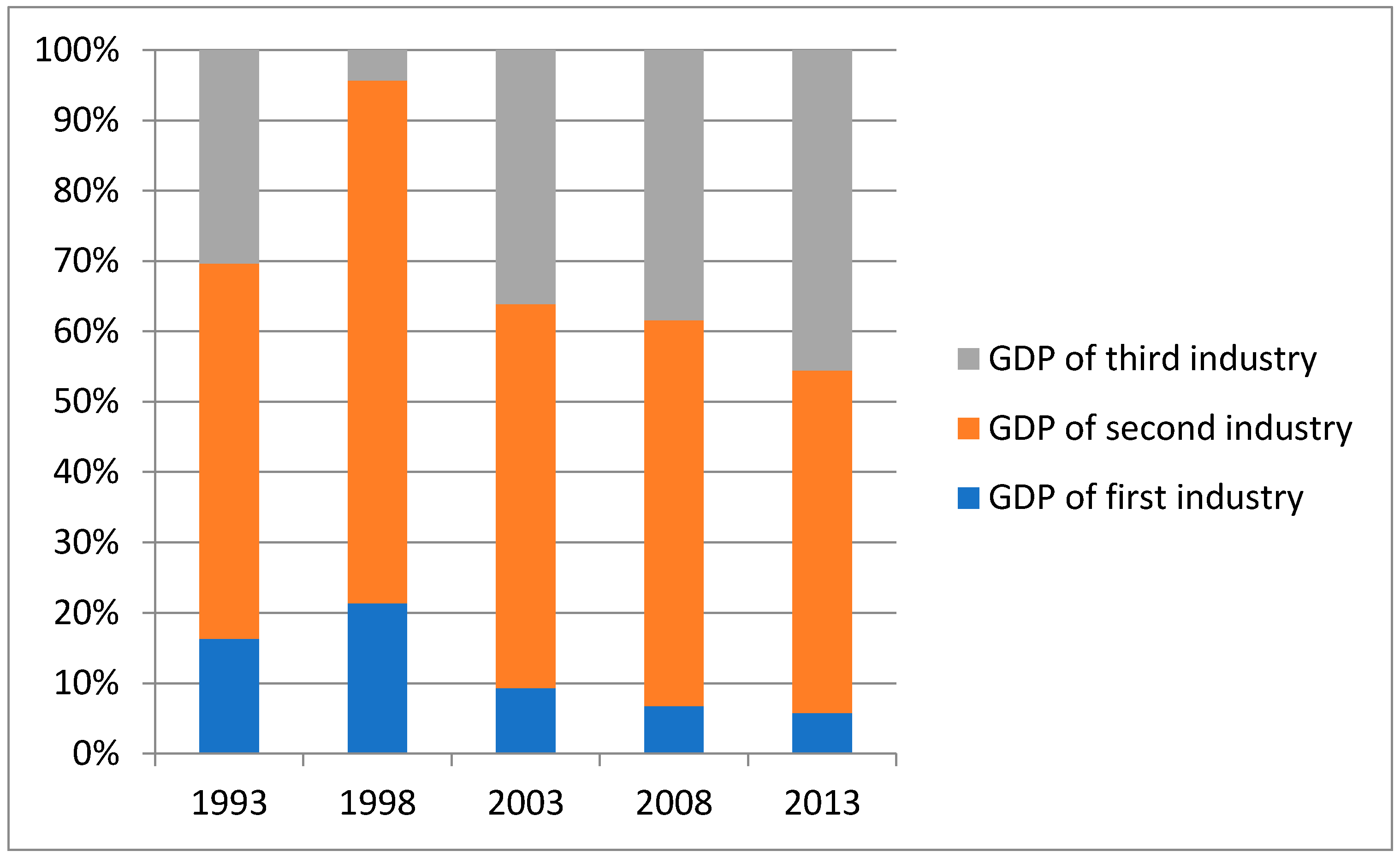
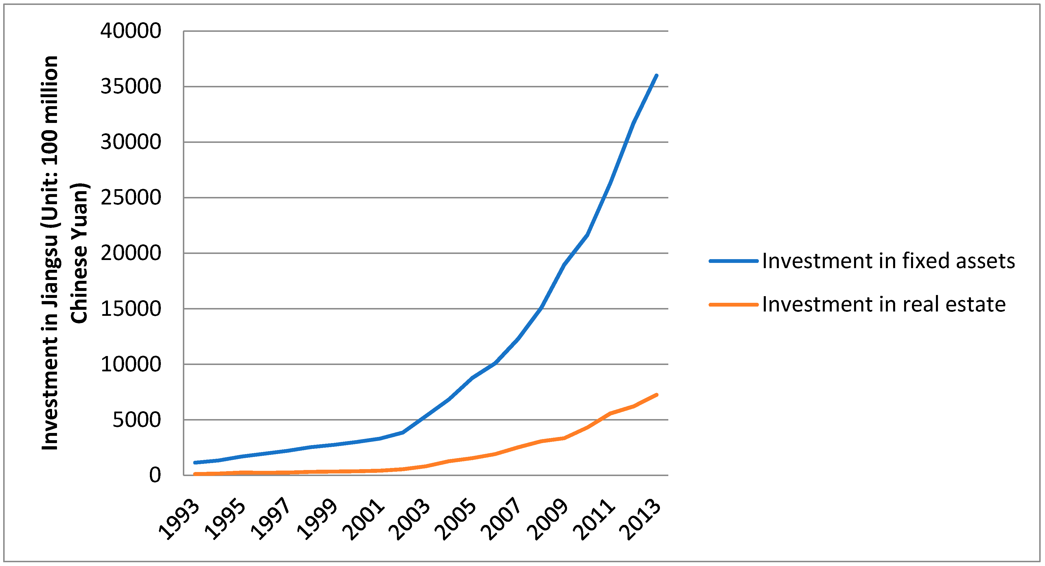
4.2. Regional Social Economic Development
5. Conclusions
Author Contributions
Funding
Acknowledgments
Conflicts of Interest
Appendix A


| Year | Total Population (Unit: Ten Thousands) | Percentage of Total Population Increase | Non-Agricultural Population | Percentage of Non-Agricultural Population |
|---|---|---|---|---|
| 1993 | 6967.27 | - | 1673.58 | 24.02% |
| 1994 | 7020.54 | 0.76% | 1733.01 | 24.68% |
| 1995 | 7066.02 | 0.65% | 1929.09 | 27.3% |
| 1996 | 7110.16 | 0.62% | 1942.5 | 27.32% |
| 1997 | 7147.86 | 0.53% | 2133.64 | 29.85% |
| 1998 | 7182.46 | 0.48% | 2262.47 | 31.49% |
| 1999 | 7213.13 | 0.43% | 2520.09 | 34.94% |
| 2000 | 7327.24 | 1.58% | 3040.81 | 41.5% |
| 2001 | 7358.52 | 0.43% | 3134.73 | 42.6% |
| 2002 | 7405.5 | 0.64% | 3310.25 | 44.7% |
| 2003 | 7457.7 | 0.7% | 3487.97 | 46.77% |
| 2004 | 7522.95 | 0.87% | 3624.56 | 48.18% |
| 2005 | 7588.24 | 0.87% | 3832.06 | 50.5% |
| 2006 | 7655.66 | 0.89% | 3973.29 | 51.9% |
| 2007 | 7723.13 | 0.88% | 4108.7 | 53.20% |
| 2008 | 7762.48 | 0.5% | 4215.17 | 54.3% |
| 2009 | 7810.27 | 0.61% | 4342.51 | 55.6% |
| 2010 | 7869.34 | 0.76% | 4767.63 | 60.58% |
| 2011 | 7898.8 | 0.37% | 4889.36 | 61.9% |
| 2012 | 7919.98 | 0.27% | 4990.09 | 63% |
| 2013 | 7939.49 | 0.25% | 5090.01 | 64.11% |
| Year | Investment in Fixed Assets (Unit: 100 Million Chinese Yuan) | Investment in Real Estate (Unit: 100 Million Chinese Yuan) |
|---|---|---|
| 1993 | 1144.2 | 114.01 |
| 1994 | 1331.13 | 152.42 |
| 1995 | 1680.17 | 240.85 |
| 1996 | 1949.53 | 232.62 |
| 1997 | 2203.09 | 241.55 |
| 1998 | 2535.5 | 300.24 |
| 1999 | 2742.65 | 330.55 |
| 2000 | 2995.43 | 358.72 |
| 2001 | 3302.96 | 414.36 |
| 2002 | 3849.24 | 544.13 |
| 2003 | 5335.8 | 809.96 |
| 2004 | 6827.59 | 1269.78 |
| 2005 | 8739.71 | 1545.15 |
| 2006 | 10,071.42 | 1906.71 |
| 2007 | 12,268.07 | 2515.91 |
| 2008 | 15,060.45 | 3064.46 |
| 2009 | 18,949.88 | 3338.5 |
| 2010 | 21,643.02 | 4299.38 |
| 2011 | 26,314.66 | 5567.94 |
| 2012 | 31,706.58 | 6206.1 |
| 2013 | 35,982.52 | 7241.45 |
References
- Shiu, A.; Lam, P.-L. Electricity consumption and economic growth in China. Energy Policy 2004, 32, 47–54. [Google Scholar] [CrossRef]
- Chen, J. Rapid urbanization in China: A real challenge to soil protection and food security. Catena 2007, 69, 1–15. [Google Scholar] [CrossRef]
- Zhou, L.; Dickinson, R.E.; Tian, Y.; Fang, J.; Li, Q.; Kaufmann, R.K.; Tucker, C.J.; Myneni, R.B. Evidence for a significant urbanization effect on climate in China. Proc. Natl. Acad. Sci. USA 2004, 101, 9540–9544. [Google Scholar] [CrossRef] [PubMed] [Green Version]
- Chen, H.; Jia, B.; Lau, S.S.Y. Sustainable urban form for Chinese compact cities: Challenges of a rapid urbanized economy. Habitat Int. 2008, 32, 28–40. [Google Scholar] [CrossRef]
- National Bureau of Statistics of the People’s Republic of China. China Statistical Bureau. 2017. Available online: http://www.stats.gov.cn/tjsj/ndsj/2017/indexch.htm (accessed on 15 February 2018).
- Imhoff, M.L.; Bounoua, L.; DeFries, R.; Lawrence, W.T.; Stutzer, D.; Tucker, C.J.; Ricketts, T. The consequences of urban land transformation on net primary productivity in the United States. Remote Sens. Environ. 2004, 89, 434–443. [Google Scholar] [CrossRef]
- Zhao, S.; Da, L.; Tang, Z.; Fang, H.; Song, K.; Fang, J. Ecological consequences of rapid urban expansion: Shanghai, China. Front. Ecol. Environ. 2006, 4, 341–346. [Google Scholar] [CrossRef] [Green Version]
- Kalnay, E.; Cai, M. Impact of urbanization and land-use change on climate. Nature 2003, 423, 528–531. [Google Scholar] [CrossRef] [PubMed]
- Lambin, E.F.; Meyfroidt, P. Global land use change, economic globalization, and the looming land scarcity. Proc. Natl. Acad. Sci. USA 2011, 108, 3465–3472. [Google Scholar] [CrossRef] [PubMed] [Green Version]
- Zhang, K.H.; Shunfeng, S. Rural–urban migration and urbanization in China: Evidence from time-series and cross-section analyses. China Econ. Rev. 2003, 14, 386–400. [Google Scholar] [CrossRef]
- Yixing, Z.; Ma, L.J. China’s urbanization levels: Reconstructing a baseline from the fifth population census. China Q. 2003, 173, 176–196. [Google Scholar] [CrossRef]
- Ferrari, L.; Rosi, A.; Mamei, M.; Zambonelli, F. Extracting urban patterns from location-based social networks. In Proceedings of the 3rd ACM SIGSPATIAL International Workshop on Location-Based Social Networks, Chicago, IL, USA, 1 November 2011; pp. 9–16. [Google Scholar]
- Goodchild, M.F. Citizens as sensors: The world of volunteered geography. GeoJournal 2007, 69, 211–221. [Google Scholar] [CrossRef]
- Shi, G.; Jiang, N.; Yao, L.Q. Study on the identification of urban center system based on GIS and POI—A case study of shanghai. Mod. Surv. Mapp. 2017, 6, 27–30. [Google Scholar]
- Long, Y.; Zhang, Y.; Cui, C.Y. Identifying commuting pattern of Beijing using bus smart card data. Acta Geogr. Sin. 2012, 67, 1339–1352. [Google Scholar]
- Long, Y.; Shen, Z. Discovering functional zones using bus smart card data and points of interest in Beijing. In Geospatial Analysis to Support Urban Planning in Beijing; Springer: Cham, Switzerland, 2015; pp. 193–217. [Google Scholar]
- Shi, G.; Jiang, N.; Yao, L. Land Use and Cover Change during the Rapid Economic Growth Period from 1990 to 2010: A Case Study of Shanghai. Sustainability 2018, 10, 426. [Google Scholar] [CrossRef]
- Fan, F.; Weng, Q.; Wang, Y. Land use and land cover change in Guangzhou, China, from 1998 to 2003, based on Landsat TM/ETM+ imagery. Sensors 2007, 7, 1323–1342. [Google Scholar] [CrossRef]
- Hu, T.; Yang, J.; Li, X.; Gong, P. Mapping urban land use by using Landsat images and open social data. Remote Sens. 2016, 8, 151. [Google Scholar] [CrossRef]
- Huang, F.; Huang, B.; Huang, J.; Li, S. Measuring Land Change in Coastal Zone around a Rapidly Urbanized Bay. Int. J. Environ. Res. Public Health 2018, 15, 1059. [Google Scholar] [CrossRef] [PubMed]
- Asner, G.P. Cloud cover in Landsat observations of the Brazilian Amazon. Int. J. Remote Sens. 2001, 22, 3855–3862. [Google Scholar] [CrossRef]
- Elvidge, C.D.; Baugh, K.E.; Dietz, J.B.; Bland, T.; Sutton, P.C.; Kroehl, H.W. Radiance calibration of DMSP-OLS low-light imaging data of human settlements. Remote Sens. Environ. 1999, 68, 77–88. [Google Scholar] [CrossRef]
- Imhoff, M.L.; Lawrence, W.T.; Stutzer, D.C.; Elvidge, C.D. A technique for using composite DMSP/OLS “city lights” satellite data to map urban area. Remote Sens. Environ. 1997, 61, 361–370. [Google Scholar] [CrossRef]
- Liu, Q.; Yang, Y.; Tian, H.; Bo, Z.; Lei, G. Assessment of human impacts on vegetation in built-up areas in china based on AVVHR, Modis and DMSP/OLS nighttime light data, 1992–2010. Chin. Geogr. Sci. 2014, 24, 231–244. [Google Scholar] [CrossRef]
- Huang, Q.; Yang, Y.; Li, Y.; Gao, B. A simulation study on the urban population of china based on nighttime light data acquired from DMSP/OLS. Sustainability 2016, 8, 521. [Google Scholar] [CrossRef]
- Keola, S.; Andersson, M.; Hall, O. Monitoring economic development from space: Using nighttime light and land cover data to measure economic growth. World Dev. 2015, 66, 322–334. [Google Scholar] [CrossRef]
- Liu, Z.; He, C.; Zhang, Q.; Huang, Q.; Yang, Y. Extracting the dynamics of urban expansion in china using DMSP-OLS nighttime light data from 1992 to 2008. Landsc. Urban Plan. 2012, 106, 62–72. [Google Scholar] [CrossRef]
- Yu, B.; Shu, S.; Liu, H.; Song, W.; Wu, J.; Wang, L.; Chen, Z. Object-based spatial cluster analysis of urban landscape pattern using nighttime light satellite images: A case study of china. Int. J. Geogr. Inf. Sci. 2014, 28, 2328–2355. [Google Scholar] [CrossRef]
- Jiang, W.; He, G.; Leng, W.; Long, T.; Wang, G.; Liu, H.; Peng, Y.; Yin, R.; Guo, H. Characterizing Light Pollution Trends across Protected Areas in China Using Nighttime Light Remote Sensing Data. ISPRS Int. J. Geo-Inf. 2018, 7, 243. [Google Scholar] [CrossRef]
- Zhang, C.M.; Zhang, X.L.; Qi-Yan, W.U.; Hong-Bo, L.I. The coordination about quality and scale of urbanization: Case study of Jiangsu province. Sci. Geogr. Sin. 2013, 33, 16–22. [Google Scholar]
- Zhai, W.; Huang, X.; Zhang, Q. Intensive land use potential in urban development zones: A case study in typical urban development zones in Jiangsu province. Resour. Sci. 2006, 28, 54–60. [Google Scholar]
- Du, X.; Jin, X.; Yang, X.; Yang, X.; Zhou, Y. Spatial Pattern of Land Use Change and Its Driving Force in Jiangsu Province. Int. J. Environ. Res. Public Health 2014, 11, 3215–3232. [Google Scholar] [CrossRef] [PubMed] [Green Version]
- Ou, X.; Zhen, F.; Qin, Y. Study on Compression Level and Ideal Impetus of Regional Urbanization: The Case of Jiangsu Province. 2008. Available online: http://www.dlyj.ac.cn/EN/10.11821/yj2008050003 (accessed on 20 May 2018).
- National Bureau of Statistics of the People’s Republic of China. Jiangsu Statistical Yearbook. 2017. Available online: http://www.jssb.gov.cn/2017nj/indexc.html (accessed on 20 May 2018).
- NOAA. National Centers for Environmental Information. Available online: https://www.ngdc.noaa.gov/eog/dmsp/downloadV4composites.html (accessed on 10 January 2018).
- National Science & Technology Infrastructure of China. National Earth System Science Data Sharing Infrastructure. 2015. Available online: http://www.geodata.cn (accessed on 10 January 2018).
- Lu, H.; Zhang, M.; Sun, W.; Li, W. Expansion Analysis of Yangtze River Delta Urban Agglomeration Using DMSP/OLS Nighttime Light Imagery for 1993 to 2012. ISPRS Int. J. Geo-Inf. 2018, 7, 52. [Google Scholar] [CrossRef]
- Shi, K.; Yu, B.; Huang, Y.; Hu, Y.; Yin, B.; Chen, Z.; Chen, L.; Wu, J. Evaluating the Ability of NPP-VIIRS Nighttime Light Data to Estimate the Gross Domestic Product and the Electric Power Consumption of China at Multiple Scales: A Comparison with DMSP-OLS Data. Remote Sens. 2014, 6, 1705–1724. [Google Scholar] [CrossRef] [Green Version]
- Shu, S.; Bai-Lang, Y.U.; Jian-Ping, W.U.; Liu, H.X. Methods for deriving urban built-up area using night-light data: Assessment and application. Remote Sens. Technol. Appl. 2011, 26, 169–176. [Google Scholar]
- Ma, Y.; Xu, R. Remote sensing monitoring and driving force analysis of urban expansion in Guangzhou city, China. Habitat Int. 2010, 34, 228–235. [Google Scholar] [CrossRef]
- Xiao, J.; Shen, Y.; Ge, J.; Tateishi, R.; Tang, C.; Liang, Y.; Huang, Z. Evaluating urban expansion and land use change in Shijiazhuang, China, by using GIS and remote sensing. Landsc. Urban Plan. 2006, 75, 69–80. [Google Scholar] [CrossRef]
- Liu, S.; Wu, C.; Shen, H. A GIS based model of urban land use growth in Beijing. Acta Geogr. Sin. 2000, 55, 407–416. [Google Scholar]
- Zhang, X.Y.; Huang, X.J.; Zhao, Y.T.; Wang, Q.Q.; Ru-Cheng, L.U.; Zhao, X.F. Shift route and comparative analysis of land use gravity and economy gravity center in recent ten years in Jiangsu province. Resour. Environ. Yangtze Basin 2011, 20, 14–20. [Google Scholar]
- Zhou, Q.G.; Chen, D.; Chen, Q. Research on the transfer of land use gravity centers from 1985 to 2010 in Chongqing mountainous metropolitan area. Res. Soil Water Conserv. 2013, 20, 189–193. [Google Scholar]
- Ju, H.; Zhang, Z.; Zuo, L.; Wang, J.; Zhang, S.; Wang, X.; Zhao, X. Driving forces and their interactions of built-up land expansion based on the geographical detector–a case study of Beijing, China. Int. J. Geogr. Inf. Sci. 2016, 30, 2188–2207. [Google Scholar] [CrossRef]
- Bai, X.; Chen, J.; Shi, P. Landscape urbanization and economic growth in china: Positive feedbacks and sustainability dilemmas. Environ. Sci. Technol. 2011, 46, 132–139. [Google Scholar] [CrossRef] [PubMed]
- Li, J.; Zhang, Y.; Qin, Q.; Yan, Y. Investigating the impact of human activity on land use/cover change in china’s Lijiang river basin from the perspective of flow and type of population. Sustainability 2017, 9, 383. [Google Scholar] [CrossRef]
- Rajan, R.G.; Zingales, L. Financial systems, industrial structure, and growth. Oxf. Rev. Econ. Policy 2001, 17, 467–482. [Google Scholar] [CrossRef]
- Gan, C.; Zheng, R.; Yu, D. An empirical study on the effects of industrial structure on economic growth and fluctuations in china. Econ. Res. J. 2011, 21, 85–100. [Google Scholar]


| Year | Threshold (DN Value) | Lighted Area Based on Threshold (km2) | Urban Built-Up Area Recorded in City Year Book (km2) | Deviation (%) |
|---|---|---|---|---|
| 1998 | 53 | 820.41 | 808 | 1.54 |
| 2003 | 54 | 1418.54 | 1459 | 2.77 |
| 2008 | 59 | 2189.26 | 2105 | 4.00 |
| 2013 | 62 | 3009.48 | 2930 | 2.71 |
| Year | 1998–2003 | 2003–2008 | 2008–2013 | |||
|---|---|---|---|---|---|---|
| Index | UES1998–2003 | UII1998–2003 | UES2003–2008 | UII2003–2008 | UES2008–2013 | UII2008–2013 |
| Nanjing | 53.6 | 149.72% | 30 | 33.56% | 22.2 | 18.59% |
| Wuxi | 17.2 | 91.49% | 3 | 8.33% | 18.4 | 47.18% |
| Xuzhou | 4.8 | 36.92% | 10.2 | 57.3% | 17.6 | 62.86% |
| Changzhou | 4.8 | 35.29% | 5.8 | 31.52% | 13 | 53.72% |
| Suzhou | 14 | 88.61% | 33.8 | 113.42% | 24.2 | 38.05% |
| Nantong | 5.8 | 48.33% | 5 | 28.09% | 20 | 87.72% |
| Lianyungang | 2.6 | 26% | 10.4 | 82.54% | 13 | 56.52% |
| Huaian | 8.8 | 125.71% | 8.4 | 53.16% | 18.4 | 76.03% |
| Yancheng | 6.2 | 124% | 5 | 44.64% | 2.8 | 17.28% |
| Yangzhou | 2.4 | 26.09% | 5 | 43.1% | 9.6 | 57.83% |
| Zhenjiang | 4.6 | 41.07% | 3.8 | 24.05% | 6 | 30.61% |
| Taizhou | 2.8 | 41.18% | 4.4 | 45.83% | 13.6 | 97.14% |
| Suqian | 2.6 | 76.47% | 6.2 | 103.33% | 3.4 | 27.87% |
| Southern Jiangsu | 94.2 | 98.95% | 76.4 | 40.34% | 83.8 | 31.53% |
| Central Jiangsu | 11 | 39.29% | 14.4 | 36.92% | 43.2 | 80.9% |
| Northern Jiangsu | 25 | 65.1% | 40.2 | 63.41% | 55.2 | 53.28% |
| Jiangsu Province | 130.2 | 80.57% | 131 | 44.89% | 182.2 | 43.09% |
© 2018 by the authors. Licensee MDPI, Basel, Switzerland. This article is an open access article distributed under the terms and conditions of the Creative Commons Attribution (CC BY) license (http://creativecommons.org/licenses/by/4.0/).
Share and Cite
Shi, G.; Jiang, N.; Li, Y.; He, B. Analysis of the Dynamic Urban Expansion Based on Multi-Sourced Data from 1998 to 2013: A Case Study of Jiangsu Province. Sustainability 2018, 10, 3467. https://doi.org/10.3390/su10103467
Shi G, Jiang N, Li Y, He B. Analysis of the Dynamic Urban Expansion Based on Multi-Sourced Data from 1998 to 2013: A Case Study of Jiangsu Province. Sustainability. 2018; 10(10):3467. https://doi.org/10.3390/su10103467
Chicago/Turabian StyleShi, Ge, Nan Jiang, Yang Li, and Bin He. 2018. "Analysis of the Dynamic Urban Expansion Based on Multi-Sourced Data from 1998 to 2013: A Case Study of Jiangsu Province" Sustainability 10, no. 10: 3467. https://doi.org/10.3390/su10103467
APA StyleShi, G., Jiang, N., Li, Y., & He, B. (2018). Analysis of the Dynamic Urban Expansion Based on Multi-Sourced Data from 1998 to 2013: A Case Study of Jiangsu Province. Sustainability, 10(10), 3467. https://doi.org/10.3390/su10103467