Effect of Topography on Persistent Fire Refugia of the Canadian Rocky Mountains


Abstract
:1. Introduction
2. Materials and Methods
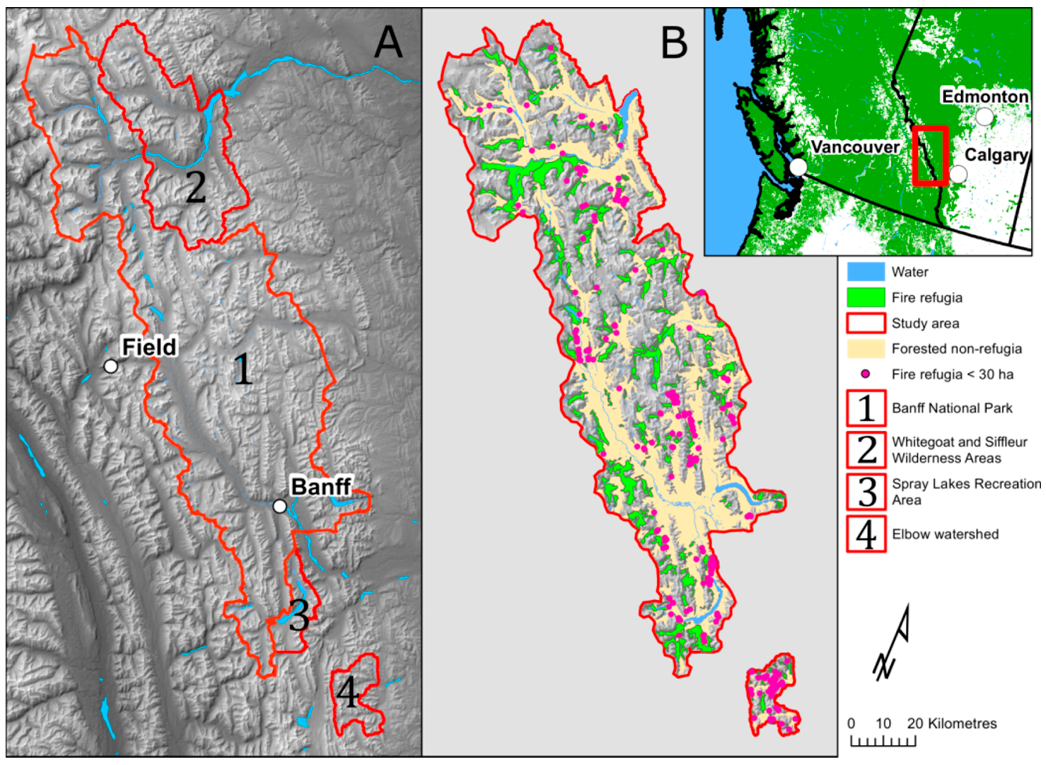
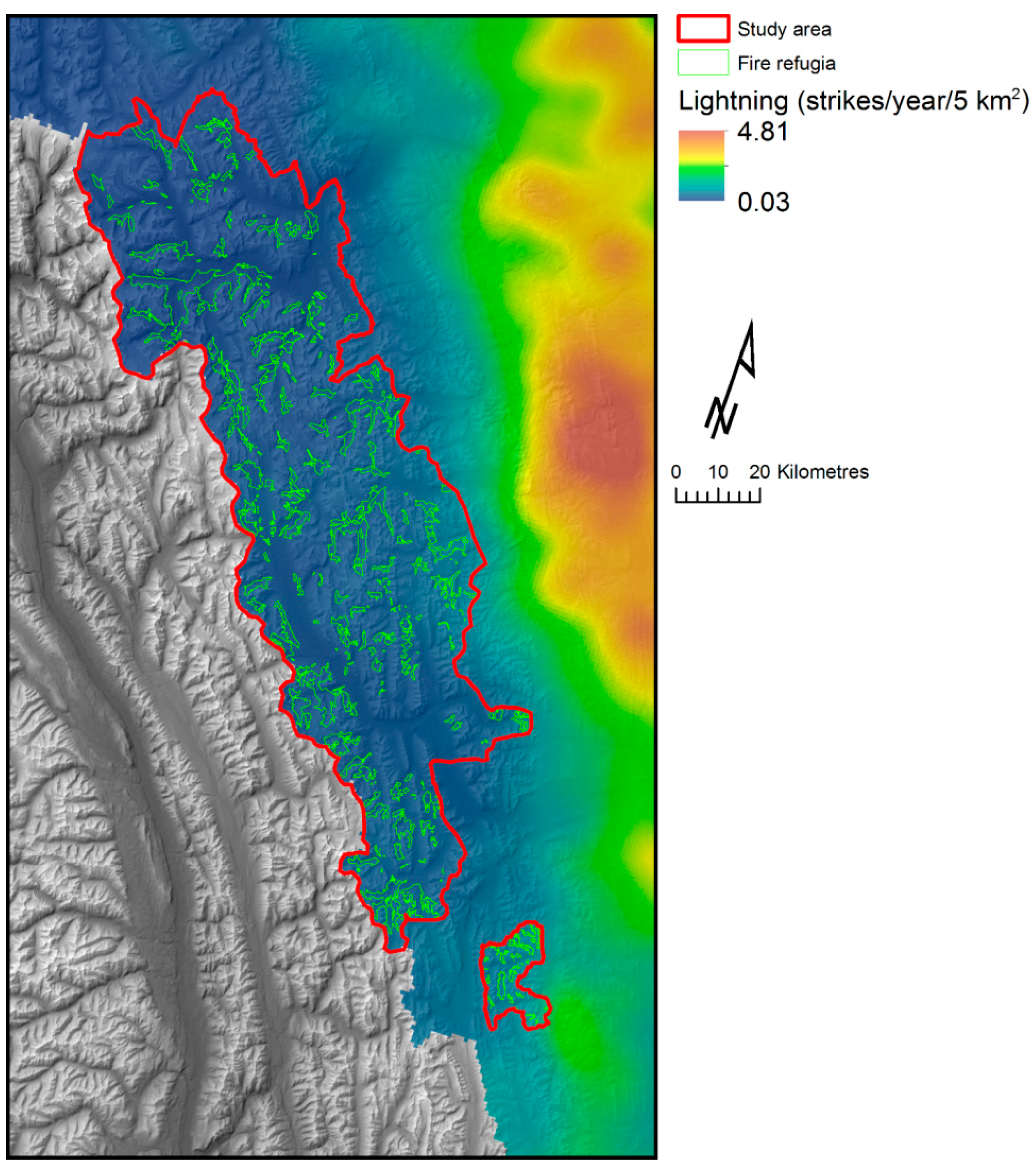
2.1. Study Area
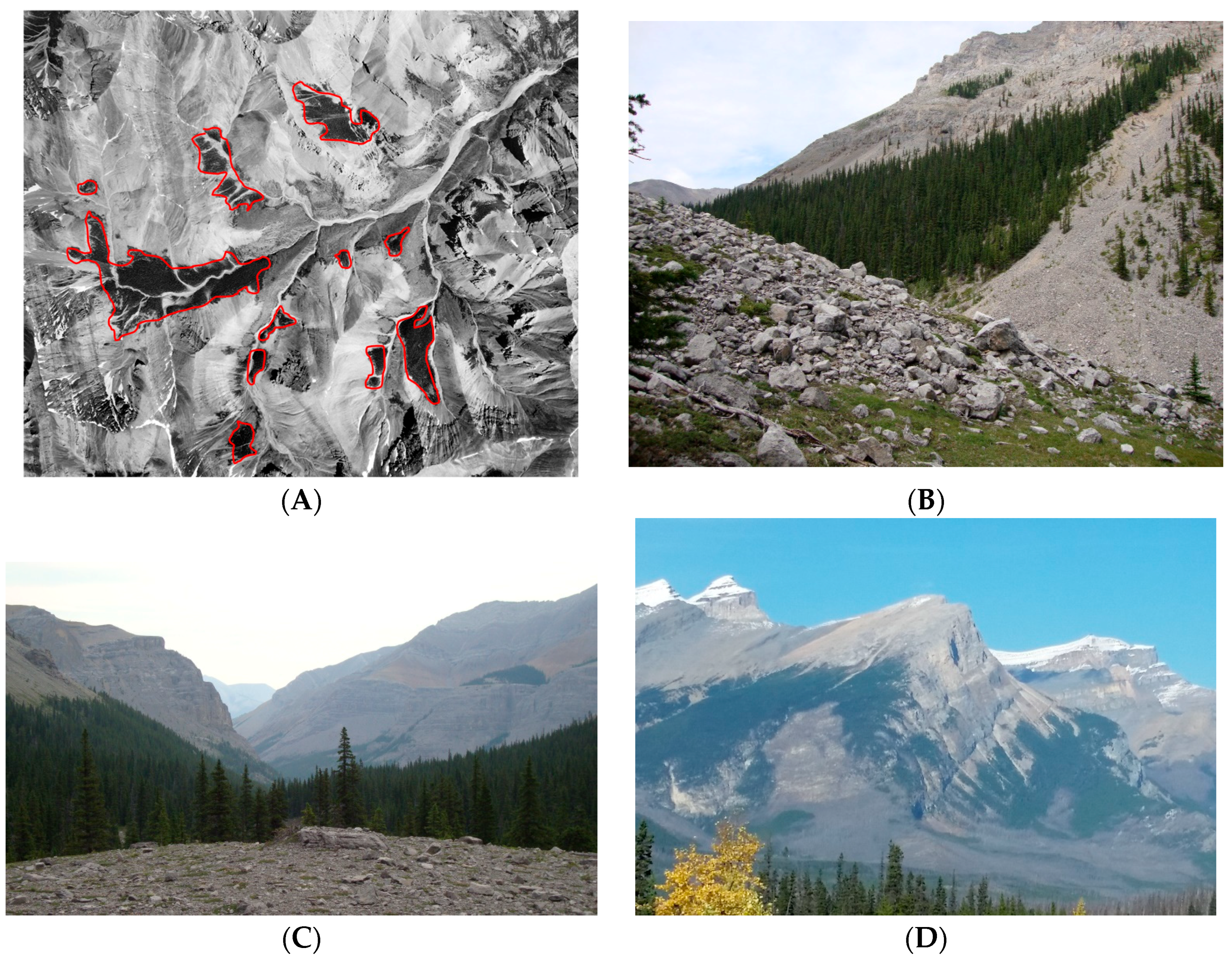
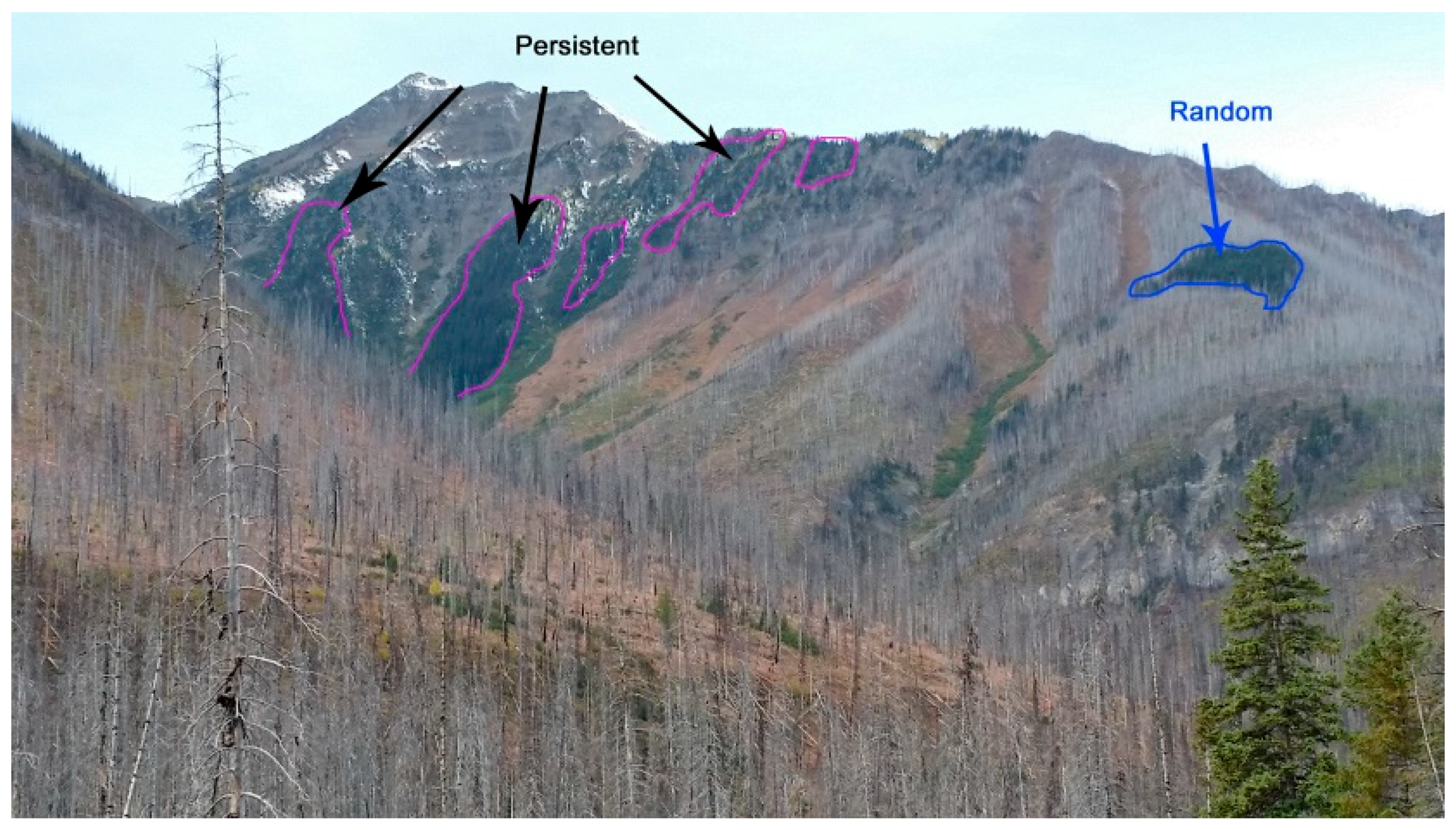
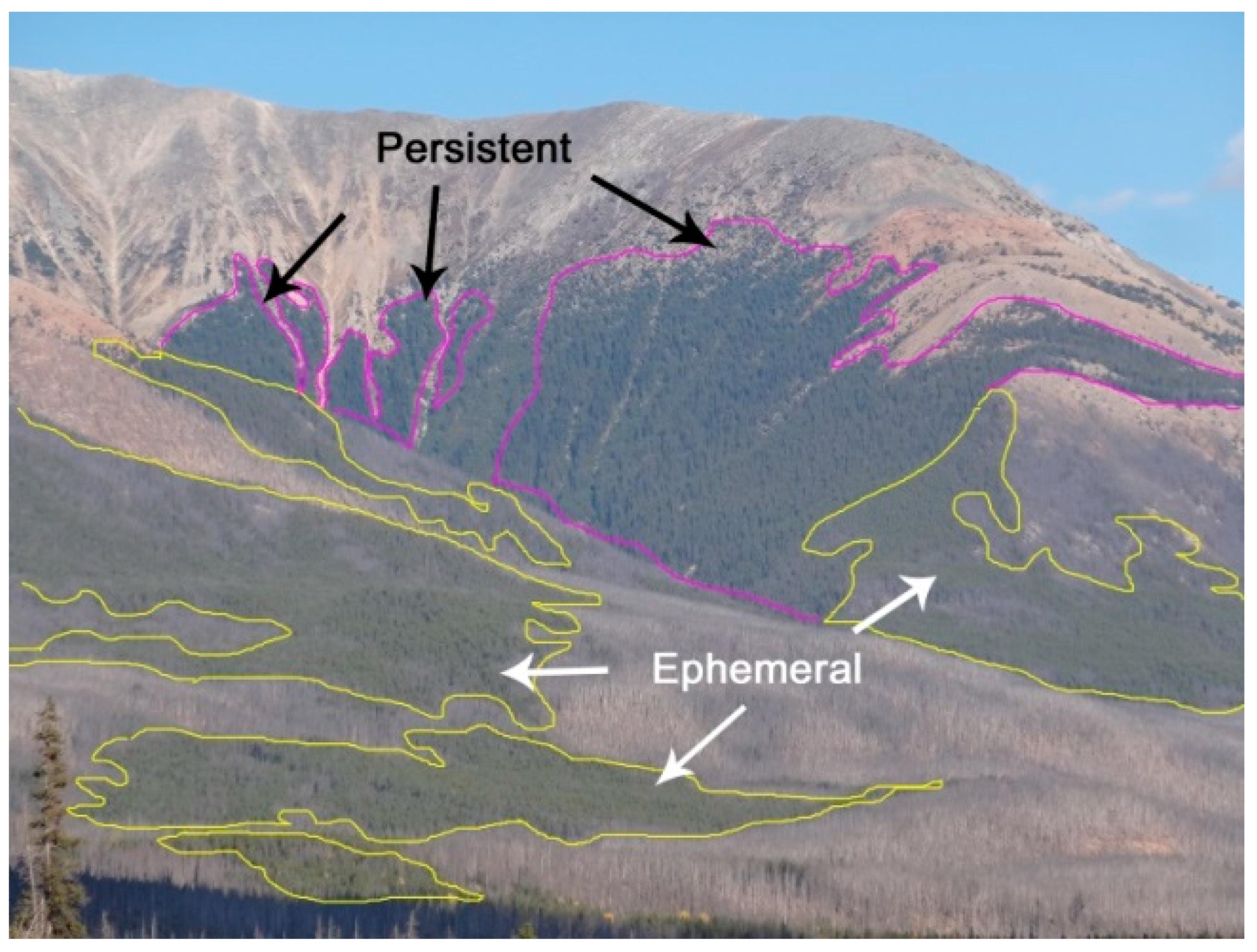
2.2. Fire Refugia Data Set
2.3. Topographic Variables Data Set
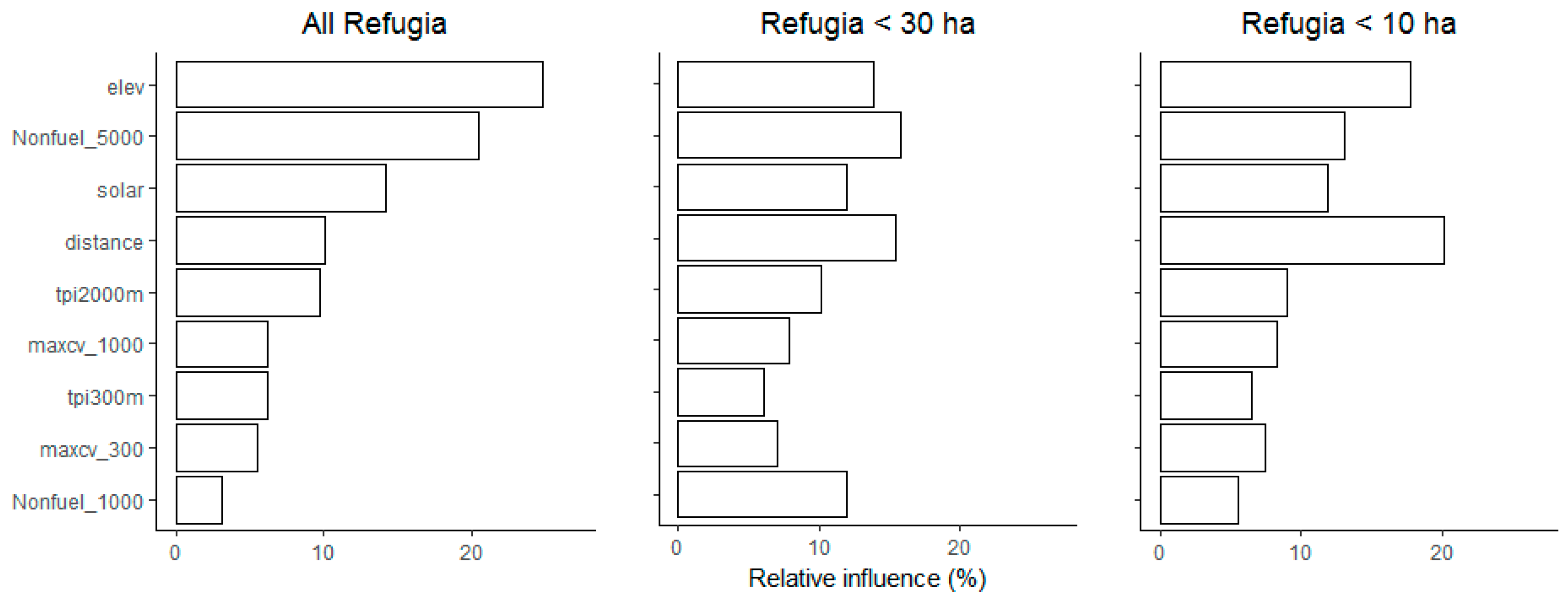
2.4. Topographic Variable Selection
2.5. Model Building and Analysis
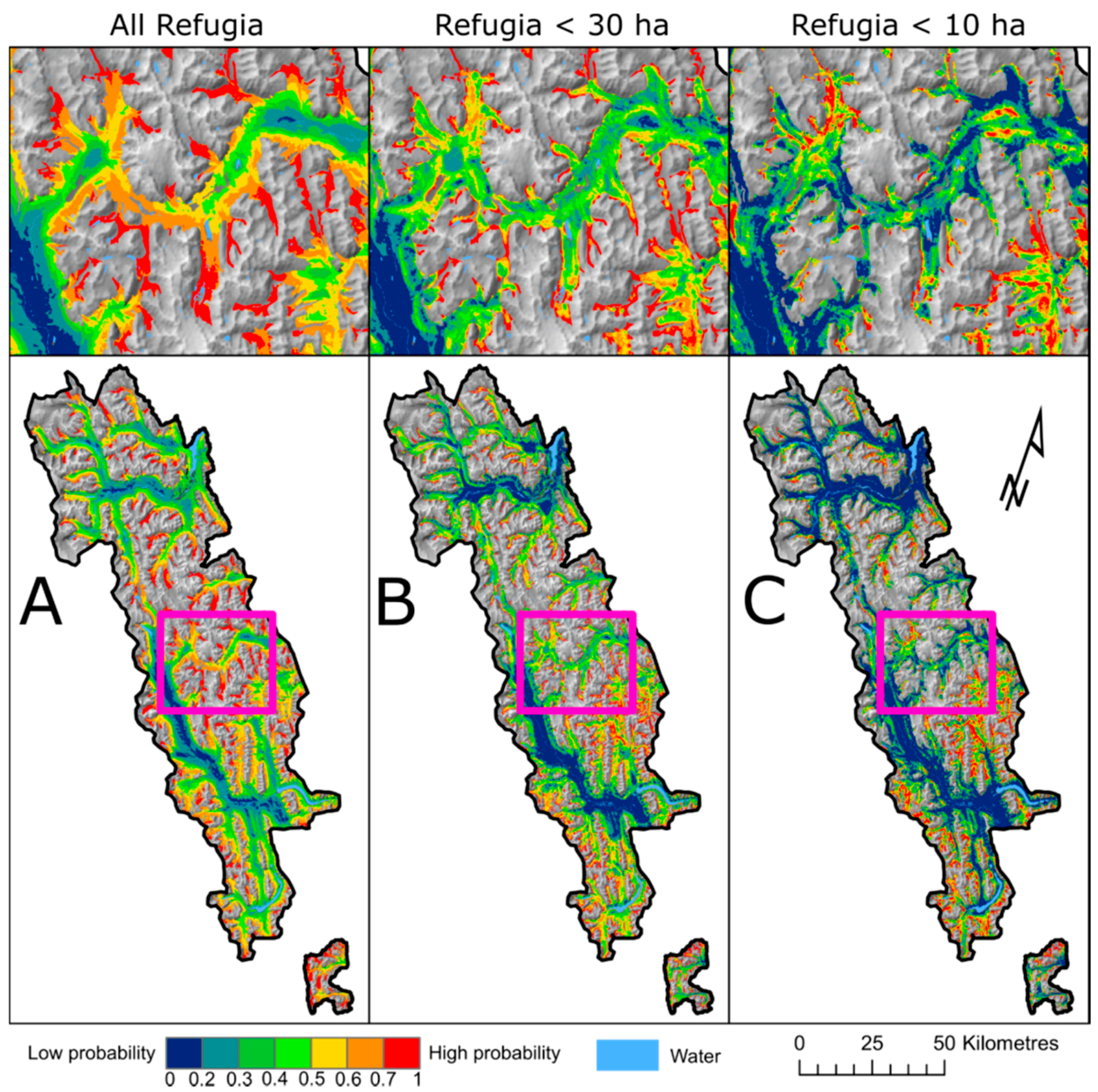
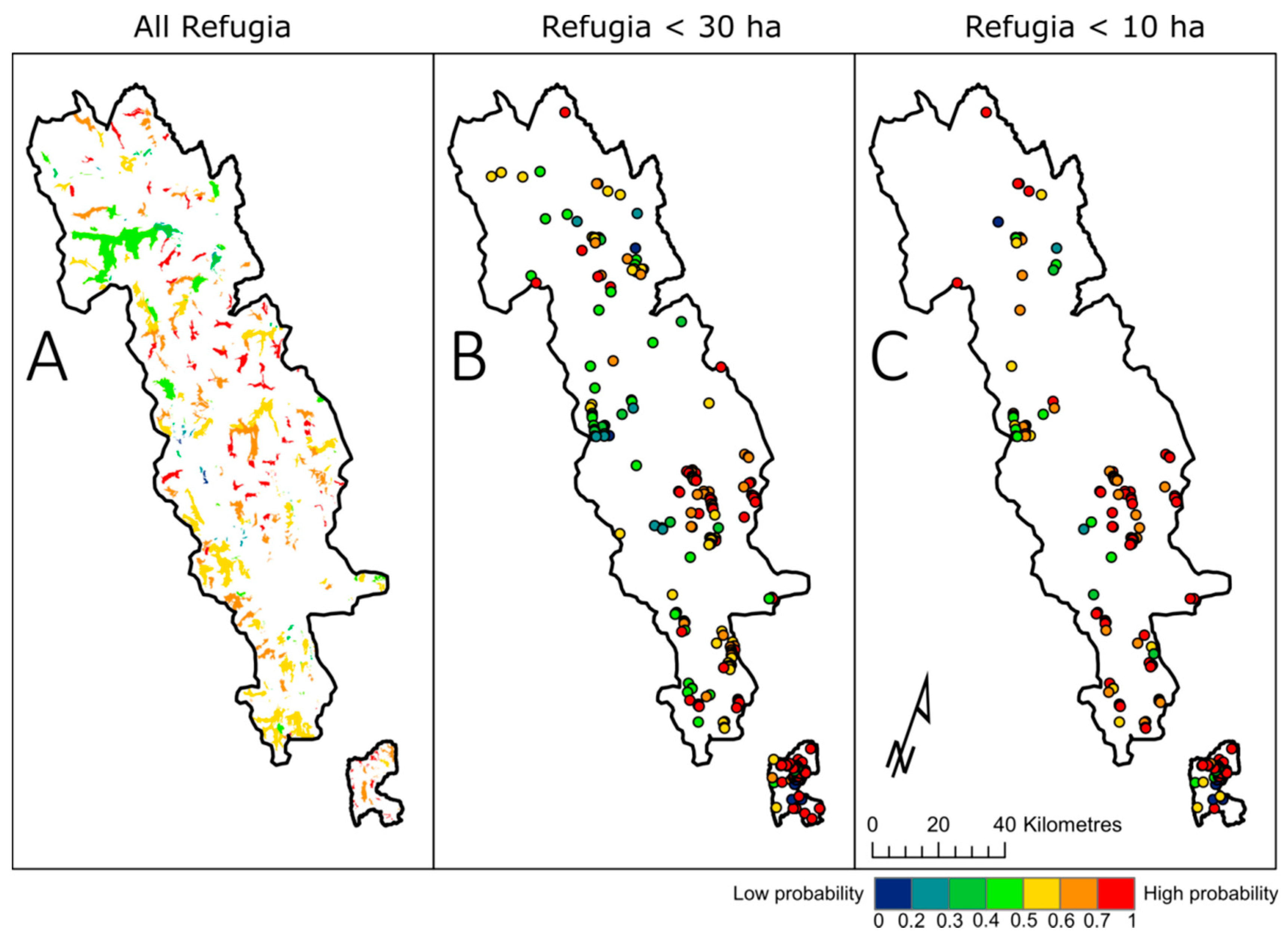
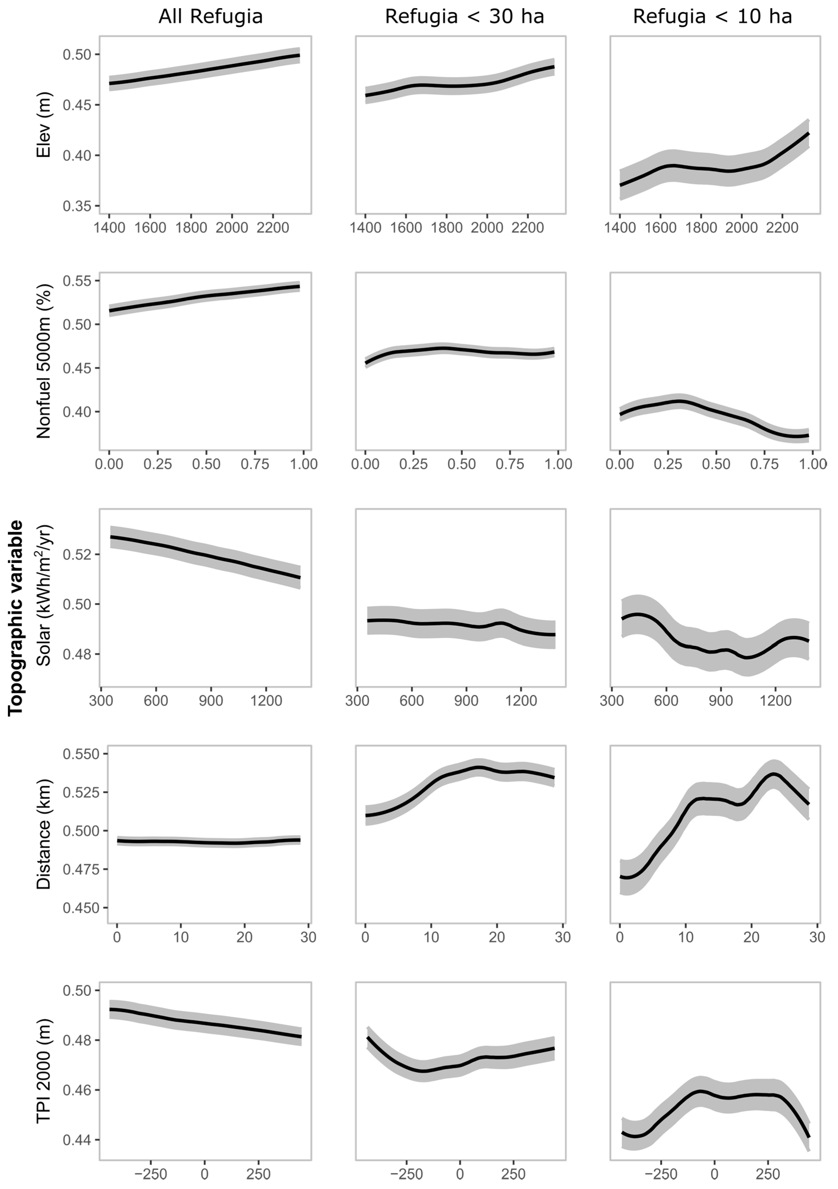
3. Results
4. Discussion
5. Conclusions
Author Contributions
Funding
Acknowledgments
Conflicts of Interest
Appendix A

| All-Refugia Model | 30 ha Model | 10 ha Model | ||||
|---|---|---|---|---|---|---|
| Refugia Probability | Forested | Refugia obs. | Forested | Refugia obs. | Forested | Refugia obs. |
| 0–10 | 0.00 | 0.00 | 5.23 | 0.27 | 21.63 | 1.27 |
| 10–20 | 5.03 | 0.74 | 12.57 | 0.58 | 18.72 | 0.89 |
| 20–30 | 14.91 | 3.91 | 14.64 | 3.28 | 13.80 | 2.66 |
| 30–40 | 16.64 | 8.53 | 17.02 | 7.10 | 10.95 | 3.80 |
| 40–50 | 17.78 | 16.35 | 17.42 | 14.93 | 9.14 | 7.47 |
| 50–60 | 18.16 | 21.49 | 13.91 | 17.81 | 8.64 | 11.39 |
| 60–70 | 16.58 | 25.95 | 8.96 | 17.72 | 7.29 | 15.06 |
| 70–80 | 10.63 | 22.32 | 5.65 | 14.43 | 5.71 | 21.01 |
| 80–90 | 0.27 | 0.70 | 4.20 | 19.96 | 3.35 | 23.16 |
| 90–100 | 0.00 | 0.00 | 0.40 | 3.91 | 0.76 | 13.29 |
| >50% | 45.63 | 70.46 | 33.12 | 73.83 | 25.76 | 83.92 |
| >70% | 10.90 | 23.02 | 10.25 | 38.31 | 9.83 | 57.47 |

References
- Franklin, J.F.; Lindenmayer, D.; MacMahon, J.A.; McKee, A.; Magnuson, J.; Perry, D.A.; Waide, R.; Foster, D. Threads of continuity. Conserv. Pract. 2000, 1, 8–17. [Google Scholar] [CrossRef]
- Camp, A.; Oliver, C.; Hessburg, P.; Everett, R. Predicting late-successional fire refugia pre-dating European settlement in the Wenatchee Mountains. For. Ecol. Manag. 1997, 95, 63–77. [Google Scholar] [CrossRef]
- Ouarmim, S.; Ali, A.A.; Asselin, H.; Hély, C.; Bergeron, Y. Evaluating the persistence of post-fire residual patches in the eastern Canadian boreal mixedwood forest. Boreas 2015, 44, 230–239. [Google Scholar] [CrossRef]
- Krawchuk, M.A.; Haire, S.L.; Coop, J.; Parisien, M.-A.; Whitman, E.; Chong, G.; Miller, C. Topographic and fire weather controls of fire refugia in forested ecosystems of northwestern North America. Ecosphere 2016, 7, e01632. [Google Scholar] [CrossRef]
- Haire, S.; Coop, J.; Miller, C. Characterizing spatial neighborhoods of refugia following large fires in Northern New Mexico USA. Land 2017, 6, 19. [Google Scholar] [CrossRef]
- Beierle, B.; Smith, D.G. Severe drought in the early Holocene (10,000–6800 BP) interpreted from lake sediment cores, Southwestern Alberta, Canada. Palaeogeogr. Palaeoclimatol. 1998, 140, 75–83. [Google Scholar] [CrossRef]
- Hallett, D.J.; Mathewes, R.W.; Walker, R.C. A 1000-year record of forest fire, drought and lake-level change in southeastern British Columbia, Canada. Holocene 2003, 13, 751–761. [Google Scholar] [CrossRef]
- Rogeau, M.-P.; Flannigan, M.D.; Hawkes, B.C.; Parisien, M.-A.; Arthur, R. Spatial and temporal variations of fire regimes in the Canadian Rocky Mountains and Foothills of Southern Alberta. Int. J. Wildland Fire 2016, 25, 1117. [Google Scholar] [CrossRef]
- Rogeau, M.-P.; Armstrong, G.W. Quantifying the effect of elevation and aspect on fire return intervals in the Canadian Rocky Mountains. For. Ecol. Manag. 2017, 384, 248–261. [Google Scholar] [CrossRef]
- Landesmann, J.B.; Morales, J.M. The importance of fire refugia in the recolonization of a fire-sensitive conifer in northern Patagonia. Plant Ecol. 2018, 219, 455–466. [Google Scholar] [CrossRef]
- Keeton, W.S.; Franklin, J.F. Fire-related landform associations of remnant old-growth trees in the southern Washington Cascade Range. Can. J. For. Res. 2004, 34, 2371–2381. [Google Scholar] [CrossRef]
- Johnson, E.; Fryer, G.I. Population dynamics in lodgepole pine-Engelmann spruce forests. Ecology 1989, 70, 1335–1345. [Google Scholar] [CrossRef]
- Kaufmann, M.R.; Moir, W.H.; Covington, W.W. Old-growth forests: What do we know about their ecology and management in the Southwest and Rocky Mountain regions? In Old-Growth Forests in the Southwest and Rocky Mountain Regions, Proceedings of a Workshop, Portal, AZ, USA, 9–13 March 1992; General Technical Report RM-213; USDA Forest Service: Washington, DC, USA, 1992; pp. 1–11. [Google Scholar]
- Kaufmann, M.R.; Binkley, D.; Fulé, P.Z.; Johnson, M.; Stephens, S.L.; Swetnam, T.W. Defining old growth for fire-adapted forests of the Western United States. Ecol. Soc. 2007, 12, 15. [Google Scholar] [CrossRef]
- Harmon, M.E.; Ferrell, W.K.; Franklin, J.F. Effects on carbon storage of conversion of old-growth forests to young forests. Science 1990, 247, 699–702. [Google Scholar] [CrossRef] [PubMed]
- Stone, M.; Emelko, M.B.; Droppo, I.G.; Silins, U. Biostabilization and erodibility of cohesive sediment deposits in wildfire-affected streams. Water Res. 2011, 45, 521–534. [Google Scholar] [CrossRef] [PubMed]
- Dosskey, M.G.; Vidon, P.; Gurwick, N.P.; Allan, C.J.; Duval, T.P.; Lowrance, R. The role of riparian vegetation in protecting and improving chemical water quality in streams. J. Am. Water Resour. Assoc. 2010, 46, 261–277. [Google Scholar] [CrossRef]
- Silins, U.; Stone, M.; Emelko, M.B.; Bladon, K.D. Sediment production following severe wildfire and post-fire salvage logging in the Rocky Mountain headwaters of the Oldman River Basin, Alberta. CATENA 2009, 79, 189–197. [Google Scholar] [CrossRef]
- Schindler, D.W.; Newbury, R.W.; Beaty, K.G.; Prokopowich, J.; Ruszczynski, T.; Dalton, J.A. Effects of a windstorm and forest fire on chemical losses from forested watersheds and on the quality of receiving streams. Can. J. Fish. Aquat. Sci. 1980, 37, 328–334. [Google Scholar] [CrossRef]
- Bladon, K.D.; Silins, U.; Wagner, M.J.; Stone, M.; Emelko, M.B.; Mendoza, C.A.; Devito, K.J.; Boon, S. Wildfire impacts on nitrogen concentration and production from headwater streams in southern Alberta’s Rocky Mountains. Can. J. For. Res. 2008, 38, 2359–2371. [Google Scholar] [CrossRef]
- Kelly, E.N.; Schindler, D.W.; St Louis, V.L.; Donald, D.B.; Vladicka, K.E. Forest fire increases mercury accumulation by fishes via food web restructuring and increased mercury inputs. Proc. Natl. Acad. Sci. USA 2006, 103, 19380–19385. [Google Scholar] [CrossRef] [PubMed]
- Emelko, M.B.; Silins, U.; Bladon, K.D.; Stone, M. Implications of land disturbance on drinking water treatability in a changing climate: Demonstrating the need for “source water supply and protection” strategies. Water Res. 2011, 45, 461–472. [Google Scholar] [CrossRef] [PubMed]
- Pyne, S.J.; Andrews, P.L.; Laven, R.D. Introduction to Wildland Fire, 2nd ed.; John Wiley and Sons Inc.: New York, NY, USA, 1996; 769p. [Google Scholar]
- Scott, A.C.; Bowman, D.M.J.S.; Bond, W.J.; Pyne, S.J.; Alexander, M.E. Fire On Earth, An Introduction; Wiley Blackwell: West Sussex, UK, 2014; ISBN 978-1-119-95356-2. [Google Scholar]
- Werth, P.A.; Potter, B.E.; Clements, C.B.; Finney, M.A.; Goodrick, S.L.; Alexander, M.E.; Cruz, M.G.; Forthofer, J.A.; McAllister, S.S. Synthesis of Knowledge of Extreme Fire Behavior: Volume I for Fire Managers; USDA Forest Service General Technical Report PNW-GTR-854; Pacific Northwest Research Station: Portland, OR, USA, 2011.
- Zackrisson, O. Influence of forest fires on the north Swedish boreal forest. Oikos 1977, 29, 22–32. [Google Scholar] [CrossRef]
- Engelmark, O. Fire history correlations to forest type and topography in northern Sweden. Ann. Bot. Fenn. 1987, 24, 317–324. [Google Scholar]
- Kushla, J.D.; Ripple, W.J. The role of terrain in a fire mosaic of a temperate coniferous forest. For. Ecol. Manag. 1997, 95, 97–107. [Google Scholar] [CrossRef]
- Rollins, M.G.; Morgan, P.; Swetnam, T. Landscape-scale controls over 20th century fire occurrence in two large Rocky Mountain (USA) wilderness areas. Landsc. Ecol. 2002, 17, 539–557. [Google Scholar] [CrossRef]
- Gavin, D.G.; Brubaker, L.B.; Lertzman, K.P. Holocene fire history of a coastal temperate rain forest based on soil charcoal radiocarbon dates. Ecology 2003, 84, 186–201. [Google Scholar] [CrossRef]
- Romme, W.H.; Knight, D.H. Fire frequency and subalpine forest succession along a topographic gradient in Wyoming. Ecology 1981, 62, 319–326. [Google Scholar] [CrossRef]
- Nielsen, S.; DeLancey, E.; Reinhardt, K.; Parisien, M.-A. Effects of lakes on wildfire activity in the boreal forests of Saskatchewan, Canada. Forests 2016, 7, 265. [Google Scholar] [CrossRef]
- Kolden, C.; Bleeker, T.; Smith, A.; Poulos, H.; Camp, A. Fire effects on historical wildfire refugia in contemporary wildfires. Forests 2017, 8, 400. [Google Scholar] [CrossRef]
- Beighley, M.; Bishop, J. Fire behaviour in high-elevation timber. Fire Manag. Notes 1990, 51, 23–28. [Google Scholar]
- Erni, S.; Arseneault, D.; Parisien, M.-A.; Bégin, Y. Spatial and temporal dimensions of fire activity in the fire-prone eastern Canadian taiga. Glob. Chang. Biol. 2017, 23, 1152–1166. [Google Scholar] [CrossRef] [PubMed]
- Day, R.J. Stand structure, succession, and use of southern Alberta’s Rocky Mountain forest. Ecology 1972, 53, 472–478. [Google Scholar] [CrossRef]
- Veblen, T.T. Age and size structure of subalpine forests in the Colorado Front Range. Bull. Torrey Bot. Club 1986, 113, 225. [Google Scholar] [CrossRef]
- Aplet, G.H.; Laven, R.D.; Smith, F.W. Patterns of community dynamics in Colorado Engelmann spruce-subalpine fir forests. Ecology 1988, 69, 312–319. [Google Scholar] [CrossRef]
- Rebertus, A.J.; Veblen, T.T.; Roovers, L.M.; Nystrom Mast, J. Structure and dynamics of old-growth Engelman spruce—Subalpine fir in Colorado. In Old-Growth Forests in the Southwest and Rocky Mountain Regions, Proceedings of a Workshop, Portal, AZ, USA, 9–13 March 1992; General Technical Report RM-213; USDA Forest Service: Washington, DC, USA, 1992; pp. 139–153. [Google Scholar]
- Moir, W.H. Ecological concepts in old-growth forest definition. In Old-Growth Forests in the Southwest and Rocky Mountain Regions, Proceedings of a Workshop, Portal, AZ, USA, 9–13 March 1992; General Technical Report RM-213; USDA Forest Service: Washington, DC, USA, 1992; pp. 18–23. [Google Scholar]
- Mehl, M.S. Old-growth descriptions for the major forest cover types in the Rocky Mountain Region. In Old-Growth Forests in the Southwest and Rocky Mountain Regions, Proceedings of a Workshop, Portal, AZ, USA, 9–13 March 1992; General Technical Report RM-213; USDA Forest Service: Washington, DC, USA, 1992; pp. 106–120. [Google Scholar]
- Wierzchowski, J.; Heathcott, M.; Flannigan, M.D. Lightning and lightning fire, central cordillera, Canada. Int. J. Wildland Fire 2002, 11, 41. [Google Scholar] [CrossRef]
- White, C. Wildland Fires in Banff National Park, 1880–1980; Occasional Paper No.3; Catalogue No.: R61 2/8-E; National Parks Branch, Parks Canada, Environment Canada: Gatineau, QC, Canada, 1985.
- Rogeau, M.-P.; Pengelly, I.; Fortin, M.-J. Using a topography model to map historical fire cycles and monitor current fire cycles in Banff National Park. In Fire in Temperate, Boreal, and Montane Ecosystems, Proceedings of the 22nd Tall Timbers Fire Ecology Conference, Kananaskis, AB, Canada, 15–18 October 2001; Engstrom, R.T., de Groot, W.J., Eds.; Tall Timbers Research Station: Tallahassee, FL, USA, 2004; pp. 55–69. [Google Scholar]
- Rogeau, M.-P.; Gilbride, D. Stand Origin Mapping of Banff National Park; Banff National Park, Resource Conservation Branch: Banff, AB, Canada, 1994.
- Rogeau, M.-P. Fire History Study of the Spray Lakes Area, Alberta; Central Rockies Ecosystem Inter-Agency Liaison Group, Kananaskis Country: Canmore, AB, Canada, 1994. [Google Scholar]
- Rogeau, M.-P. Understanding Age-Class Distributions in the Southern Canadian Rockies. Master’s Thesis, University of Alberta, Edmonton, AB, Canada, 1996. [Google Scholar]
- Rogeau, M.-P. Fire History Study of the Central Rockies Ecosystem Inter-Agency North-Saskatchewan Unit; Banff National Park, Resource Conservation Branch: Banff, AB, Canada, 1999. [Google Scholar]
- Rogeau, M.-P. Fire History Study of the Elbow Fire Management Compartment, Alberta; Alberta Sustainable Resource Development, Southern Rockies Area: Calgary, AB, Canada, 2011. [Google Scholar]
- Johnson, E.A.; Gutsell, S.L. Fire frequency models, methods and interpretations. Adv. Ecol. Res. 1994, 25, 239–287. [Google Scholar] [CrossRef]
- Rogeau, M.-P.; Parisien, M.-A.; Flannigan, M.D. Fire history sampling strategy of fire intervals associated with mixed- to full-severity fires in Southern Alberta, Canada. For. Sci. 2016, 62, 613–622. [Google Scholar] [CrossRef]
- Bekker, M.F.; Taylor, A.H. Gradient analysis of fire regimes in montane forests of the southern Cascade Range, Thousand Lakes Wilderness, California, USA. Plant Ecol. 2001, 155, 15–28. [Google Scholar] [CrossRef]
- Taylor, A.H.; Skinner, C.N. Spatial patterns and controls on historical fire regimes and forest structure in the Klamath Mountains. Ecol. Appl. 2003, 13, 704–719. [Google Scholar] [CrossRef]
- De Reu, J.; Bourgeois, J.; Bats, M.; Zwertvaegher, A.; Gelorini, V.; de Smedt, P.; Chu, W.; Antrop, M.; de Maeyer, P.; Finke, P.; et al. Application of the topographic position index to heterogeneous landscapes. Geomorphology 2013, 186, 39–49. [Google Scholar] [CrossRef]
- Environmental Systems Research Institute (ESRI). ArcGIS Release 10.5; ESRI: Redlands, CA, USA, 2016; Available online: https://www.arcgis.com/features/index.html (accessed on 24 March 2018).
- Holland, W.D.; Coen, G.M. Ecological Land Classification of Banff and Jasper National Parks; Alberta Institute of Pedology Publication M-83-2; Alberta Institute of Pedology: Edmonton, AB, Canada, 1982. [Google Scholar]
- Sánchez-Azofeifa, G.A.; Chong, M.; Sinkwich, J.; Mamet, S. Alberta Ground Cover Characterization (AGCC)—Training and Procedures Manual; University of Alberta: Edmonton, AB, Canada, 2004. [Google Scholar]
- Alberta Government. Alberta Ground Cover Classification Mosaic. Available online: https://open.alberta.ca /opendata/alberta-ground-cover-classification-mosaic (accessed on 24 March 2018).
- Government of Canada. Digital Elevation Model of the Canadian Landmass—Canada3D. Available online: https://open.canada.ca/data/en/dataset/042f4628-94b2-40ac-9bc1-ca3ac2a27d82 (accessed on 24 March 2018).
- Parks, S.A.; Parisien, M.-A.; Miller, C. Multi-scale evaluation of the environmental controls on burn probability in a southern Sierra Nevada landscape. Int. J. Wildland Fire 2011, 20, 815–828. [Google Scholar] [CrossRef]
- Clarks Lab. Idrisi TerreSet Version 18.31. Available online: https://clarklabs.org/terrset/ (accessed on 24 March 2018).
- R Development Core Team. A Language and Environment for Statistical Computing; R Foundation for Statistical Computing: Vienna, Austria, 2018; ISBN 3-900051-07-0. Available online: https://www.r-project.org/ (accessed on 24 March 2018).
- Wilkin, K.; Ackerly, D.; Stephens, S. Climate change refugia, fire ecology and management. Forests 2016, 7, 77. [Google Scholar] [CrossRef]
- Elith, J.; Leathwick, J.R.; Hastie, T. A working guide to boosted regression trees. J. Anim. Ecol. 2008, 77, 802–813. [Google Scholar] [CrossRef] [PubMed]
- De’Ath, G. Boosted trees for ecological modeling and prediction. Ecology 2007, 88, 243–251. [Google Scholar] [CrossRef]
- Parisien, M.-A.; Parks, S.A.; Krawchuk, M.A.; Flannigan, M.D.; Bowman, L.M.; Moritz, M.A. Scale-dependent controls on the area burned in the boreal forest of Canada, 1980–2005. Ecol. Appl. 2011, 21, 789–805. [Google Scholar] [CrossRef] [PubMed]
- Ridgeway, G. GBM: Generalized Boosted Regression Models. R Package Version 2.1.3. Available online: https://CRAN.R-project.org/package=gbm (accessed on 24 March 2018).
- Hijmans, R.J. Raster: Geographic Data Analysis and Modeling. R Package Version 2.6-7. Available online: https://CRAN.R-project.org/package=raster (accessed on 24 March 2018).
- Lee, H.-J.; Choi, Y.; Lee, S.-W. Complex relationships of the effects of topographic characteristics and susceptible tree cover on burn severity. Sustainability 2018, 10, 295. [Google Scholar] [CrossRef]
- Tande, G.F. Fire history and vegetation pattern of coniferous forests in Jasper National Park, Albert. Can. J. Bot. 1979, 57, 1912–1931. [Google Scholar] [CrossRef]
- Hawkes, B.C. Fire history of Kananaskis Provincial Park—Mean fire return intervals. In Proceedings of the Fire History Workshop, Tucson, AZ, USA, 20–24 October 1980; Stokes, M.A., Dieterich, J.H., Eds.; General Technical Report RM-81, USDA Forest Service: Fort Collins, CO, USA, 1980; pp. 42–45. [Google Scholar]
- Van Wagner, C.E. Development and Structure of the Canadian Forest Fire Weather Index System; Forestry Technical Report 35; Canadian Forestry Service: Ottawa, OV, Canada, 1987.
- Sharples, J.J. An overview of mountain meteorological effects relevant to fire behaviour and bushfire risk. Int. J. Wildland Fire 2009, 18, 737. [Google Scholar] [CrossRef]
- Larsen, C.P.S. Spatial and temporal variations in boreal forest fire frequency in Northern Alberta. J. Biogeogr. 1997, 24, 663–673. [Google Scholar] [CrossRef]
- Dillon, G.K.; Holden, Z.A.; Morgan, P.; Crimmins, M.A.; Heyerdahl, E.K.; Luce, C.H. Both topography and climate affected forest and woodland burn severity in two regions of the Western US, 1984 to 2006. Ecosphere 2011, 2. [Google Scholar] [CrossRef]
- Birch, D.S.; Morgan, P.; Kolden, C.A.; Abatzoglou, J.T.; Dillon, G.K.; Hudak, A.T.; Smith, A.M.S. Vegetation, topography and daily weather influenced burn severity in central Idaho and Western Montana forests. Ecosphere 2015, 6. [Google Scholar] [CrossRef]
- Parks, S.; Holsinger, L.; Panunto, M.; Jolly, W.M.; Dobrowski, S.; Dillon, G. High severity fire: Evaluating its key drivers and mapping its probability across western US forests. Environ. Res. Lett. 2018, 13. [Google Scholar] [CrossRef]
- Ouarmim, S.; Paradis, L.; Asselin, H.; Bergeron, Y.; Ali, A.; Hély, C. Burning potential of fire refuges in the boreal mixedwood forest. Forests 2016, 7, 246. [Google Scholar] [CrossRef]
- Héon, J.; Arseneault, D.; Parisien, M.-A. Resistance of the boreal forest to high burn rates. Proc. Natl. Acad. Sci. USA 2014, 111, 13888–13893. [Google Scholar] [CrossRef] [PubMed]
- Parks, S.A.; Miller, C.; Holsinger, L.M.; Baggett, L.S.; Bird, B.J. Wildland fire limits subsequent fire occurrence. Int. J. Wildland Fire 2016, 25, 182–190. [Google Scholar] [CrossRef]
- Erni, S.; Arseneault, D.; Parisien, M.-A. Stand age influence on potential wildfire ignition and spread in the boreal forest of Northeastern Canada. Ecosystems 2018, 11, 45005. [Google Scholar] [CrossRef]
- DeLong, S.C.; Kessler, W.B. Ecological characteristics of mature forest remnants left by wildfire. For. Ecol. Manag. 2000, 131, 93–106. [Google Scholar] [CrossRef]
- Kafka, V.; Gauthier, S.; Bergeron, Y. Fire impacts and crowning in the boreal forest: Study of a large wildfire in Western Quebec. Int. J. Wildland Fire 2001, 10, 119–127. [Google Scholar] [CrossRef]
- Stephens, S.L.; Burrows, N.; Buyantuyev, A.; Gray, R.W.; Keane, R.E.; Kubian, R.; Liu, S.; Seijo, F.; Shu, L.; Tolhurst, K.G.; et al. Temperate and boreal forest mega-fires: Characteristics and challenges. Front. Ecol. Environ. 2014, 12, 115–122. [Google Scholar] [CrossRef]
- Schwartz, M.W.; Butt, N.; Dolanc, C.R.; Holguin, A.; Moritz, M.A.; North, M.P.; Safford, H.D.; Stephenson, N.L.; Thorne, J.H.; van Mantgem, P.J. Increasing elevation of fire in the Sierra Nevada and implications for forest change. Ecosphere 2015, 6. [Google Scholar] [CrossRef]
- Cansler, C.A.; McKenzie, D.; Halpern, C.B. Area burned in alpine treeline ecotones reflects region-wide trends. Int. J. Wildland Fire 2017, 25, 1209–1220. [Google Scholar] [CrossRef]
- Bleeker, T.M. Sustainability of Historic Wildfire Refugia in Contemporary Wildfire Events. Master’s Thesis, University of Idaho, Moscow, ID, USA, 2015. [Google Scholar]
- Flannigan, M.D.; Krawchuk, M.A.; de Groot, W.J.; Wotton, B.M.; Gowman, L.M. Implications of changing climate for global wildland fire. Int. J. Wildland Fire 2009, 18, 483–507. [Google Scholar] [CrossRef]
- Johnson, E.A.; Wowchuk, D.R. Wildfires in the southern Canadian Rocky Mountains and their relationship to mid-tropospheric anomalies. Can. J. For. Res. 1993, 23, 1213–1222. [Google Scholar] [CrossRef]
- Keane, R.E.; Ryan, K.C.; Veblen, T.T.; Allen, C.D.; Logan, J.; Hawkes, B. Cascading Effects of Fire Exclusion in the Rocky Mountain Ecosystems: A Literature Review; USDA Forest Service General Technical Report RMRSGTR-91; Rocky Mountain Research Station: Fort Collins, CO, USA, 2002.


| Variable Name | Description | Min. | Max. | Mean | STD |
|---|---|---|---|---|---|
| Elev | Elevation (m) | 1291 | 3543 | 2163 | 383 |
| maxcurv-1000 m | Maximum rate of slope curvature change in a 1000-m window | −0.0014 | 0.0181 | 0.0004 | 0.0005 |
| maxcurv-300 m | Maximum rate of slope curvature change in a 300-m window | −0.0068 | 0.0977 | 0.0011 | 0.0019 |
| Nonfuel-1000 m | Proportion of non-fuel in a 1000-m window (%) | 0 | 100.00 | 57.61 | 42.40 |
| Nonfuel-5000 m | Proportion of non-fuel in a 5000-m window (%) | 0 | 100.00 | 58.44 | 30.13 |
| Distance | Distance from rivers (m) | 0 | 32,931 | 4963 | 6356 |
| solar | Solar radiation (kWh/m2/year) | 153 | 1609 | 1078 | 204 |
| TPI-2000 m | Topographic Position Index or relative position (m) in a 2000-m window | −564.77 | 1405.91 | 0.10 | 172.38 |
| TPI-300 m | Topographic Position Index or relative position (m) in a 300-m window | −1373.27 | 661.53 | 0.01 | 14.54 |
© 2018 by the authors. Licensee MDPI, Basel, Switzerland. This article is an open access article distributed under the terms and conditions of the Creative Commons Attribution (CC BY) license (http://creativecommons.org/licenses/by/4.0/).
Share and Cite
Rogeau, M.-P.; Barber, Q.E.; Parisien, M.-A. Effect of Topography on Persistent Fire Refugia of the Canadian Rocky Mountains. Forests 2018, 9, 285. https://doi.org/10.3390/f9060285
Rogeau M-P, Barber QE, Parisien M-A. Effect of Topography on Persistent Fire Refugia of the Canadian Rocky Mountains. Forests. 2018; 9(6):285. https://doi.org/10.3390/f9060285
Chicago/Turabian StyleRogeau, Marie-Pierre, Quinn E. Barber, and Marc-André Parisien. 2018. "Effect of Topography on Persistent Fire Refugia of the Canadian Rocky Mountains" Forests 9, no. 6: 285. https://doi.org/10.3390/f9060285
APA StyleRogeau, M.-P., Barber, Q. E., & Parisien, M.-A. (2018). Effect of Topography on Persistent Fire Refugia of the Canadian Rocky Mountains. Forests, 9(6), 285. https://doi.org/10.3390/f9060285