1. Introduction
Coastal dunes are dynamic ecosystems that provide essential natural protection against storm surges, wave impacts, and coastal flooding, particularly in low-lying regions. Their stability largely depends on vegetation, which promotes sediment trapping, dune accretion, and ridge development through plant–sediment interactions [
1]. However, increasing anthropogenic pressures have resulted in widespread dune degradation, habitat loss, and reduced ecosystem services [
2]. This issue is particularly important in coastal zones, where more than half of the global population lives within 60 km of the coast, increasing pressure on these fragile environments [
3].
Mediterranean dune systems have experienced substantial decline due to urban expansion, tourism, and vegetation fragmentation [
4,
5]. These disturbances alter sediment dynamics, reduce biodiversity, and weaken coastal protection functions [
6,
7]. Restoration initiatives have demonstrated positive effects by improving sediment stabilization, promoting vegetation recovery, and enhancing shoreline resilience. However, restoration success depends on environmental conditions, degradation intensity, and time since intervention [
8,
9,
10]. Studies from Spain and other Mediterranean regions indicate that protected and restored dunes generally maintain higher ecological integrity than highly disturbed areas [
11,
12,
13]. Despite their limited extent, sandy coasts provide important ecosystem services, including erosion control, habitat conservation, carbon storage, and recreational benefits, requiring long-term monitoring to evaluate long-term dune stabilization efficiency [
14,
15,
16,
17,
18,
19].
Located at the land–sea interface, coastal dunes support highly specialized plant communities structured along environmental gradients from foredunes to inland zones [
20,
21]. Their biodiversity results from habitat heterogeneity and species adaptations, although these ecosystems remain among the most threatened natural habitats worldwide, particularly in the Mediterranean region [
7,
21,
22,
23,
24,
25,
26,
27]. Globally, dune habitats also support numerous vulnerable plant species requiring conservation efforts [
28].
In northern Tunisia, coastal dunes were formed by inland sand transport driven mainly by northwesterly winds. When not limited by natural barriers such as wadis, agricultural areas, or vegetation cover, these dunes may encroach on surrounding lands and settlements [
29]. Due to their ecological sensitivity, the extreme northern coast remained relatively isolated from socio-economic development until the late 1990s [
30]. Since the colonial period, dune stabilization and reforestation programs have been implemented through mechanical fixation, soil conservation, and vegetation planting. However, dune stability remains vulnerable to land clearing, fires, informal tourism, and increasing development pressure. The Zouaraa–Nefza dune complex has been one of the main areas targeted by these restoration efforts [
31].
Dune stability in Tunisia results from interactions between physical processes, such as wind and sand transport, and biological processes, including vegetation establishment and soil development. Vegetation reduces aeolian sand mobility and enhances dune consolidation [
32,
33]. Stabilization interventions have increased vegetation cover and improved dune stability, confirming the effectiveness of revegetation strategies [
34]. Initiated in the early 1960s by Tunisian Forest Services, large-scale stabilization programs aimed to control approximately 50,000 ha of mobile sands threatening forests, pastoral ecosystems, settlements, and economic activities in the coastal region [
29,
35,
36]. Following these interventions, the Zouaraa dunes have experienced a largely natural recovery trajectory with limited human disturbance [
35].
The restored coastal forests of northwestern Tunisia are mainly composed of
Pinus pinea,
Pinus pinaster, and
Acacia spp., established to reduce sand mobility and enhance vegetation development [
37].
Pinus pinea dominates the study area and contributes significantly to biomass accumulation and carbon storage, whereas
Pinus pinaster provides additional adaptation capacity in coastal environments. However, differences in species traits may influence their responses to disturbances, particularly wildfire, affecting biomass loss, vegetation recovery, and carbon dynamics.
Despite decades of restoration activities, the long-term effectiveness of Tunisian dune rehabilitation has not been quantitatively assessed using spatially explicit approaches. Previous evaluations have mainly relied on field observations and administrative records, limiting their capacity to detect landscape-scale changes. Furthermore, the effects of wildfire on restored coastal dunes remain poorly understood. Fire can reduce vegetation cover, biomass stocks, and dune stability by exposing previously stabilized surfaces to renewed erosion. Therefore, an integrated assessment linking recovery trajectories, fire impacts, and carbon dynamics is still lacking for Tunisian coastal ecosystems.
Wildfire is a major disturbance affecting forest biomass, vegetation structure, and ecosystem functioning [
38,
39]. Its effects depend strongly on fire intensity and severity, with low-intensity fires potentially increasing diversity, while severe fires generally cause major ecological degradation [
40]. Fire frequency and severity also influence understory composition and forest dynamics, as understory communities are highly sensitive to disturbances [
41,
42,
43,
44,
45]. Mediterranean ecosystems are particularly exposed to wildfire due to prolonged drought, high temperatures, and low humidity. Although fire has historically shaped Mediterranean vegetation by favoring adaptive traits such as serotiny, thick bark, persistent seed banks, and resprouting capacity [
46,
47,
48,
49], increasing fire frequency and severity threaten ecosystem resilience [
50].
Coastal dune forests are especially vulnerable because vegetation develops under severe environmental constraints, including nutrient limitation, water scarcity, high radiation, wind exposure, salt spray, and active sand dynamics [
51,
52,
53]. These conditions generate highly dynamic ecosystems where vegetation patterns vary along coastal gradients [
22,
54,
55]. Wildfires may alter vegetation composition, stand structure, soil properties, and ecosystem processes, with fire severity strongly influencing post-fire recovery and potential dune destabilization [
56,
57]. Recent studies also show that fire can favor opportunistic species and modify woody vegetation communities in coastal dunes [
58]. Beyond vegetation, wildfire affects soil properties, hydrological processes, water quality, insects, and soil fauna, with consequences for biodiversity and ecosystem functioning [
59]. The increasing occurrence of severe wildfires therefore highlights the need for improved assessment of post-fire recovery and ecosystem resilience [
60].
Remote sensing (RS) provides an effective framework for monitoring reforestation effectiveness, vegetation changes, and disturbance impacts at landscape scales. Long-term Landsat archives and dense satellite time series have improved the detection of forest disturbances and recovery trajectories over several decades [
61,
62,
63]. Although early bi-temporal and supervised classification approaches were useful for detecting major changes, they were limited in capturing gradual transitions and ecosystem recovery processes [
64]. Recent advances in RS and Geographic Information System (GIS) allow more comprehensive evaluation of forest landscape restoration by integrating vegetation recovery, biomass dynamics, ecosystem functioning, and landscape resilience indicators [
65,
66,
67]. These approaches provide cost-effective tools for long-term stabilization monitoring and sustainable ecosystem management [
68].
The objectives of this study are to assess the long-term effects of reforestation effectiveness and coastal dune stabilization in the Zouaraa dune ecosystem. Specifically, this study aims to (i) quantify temporal changes in vegetation cover and the extent of sandy areas since the establishment of forest plantations using Landsat time-series data; (ii) analyze spatio-temporal land cover transitions to evaluate the contribution of afforestation practices to dune stabilization while distinguishing the effects of anthropogenic activities; and (iii) assess the impacts of wildfire on reforested stands by quantifying post-fire changes in vegetation cover, biomass, and carbon loss.
The primary aim of this study is to evaluate the effectiveness of coastal afforestation and dune stabilization efforts and to quantify land cover changes over time using RS and GIS tools, including the spatio-temporal dynamics of forest cover. Finally, the study investigates the effects of fire on ecosystem resilience and post-fire recovery trajectories, as well as on biomass and carbon loss.
2. Materials and Methods
2.1. Study Area
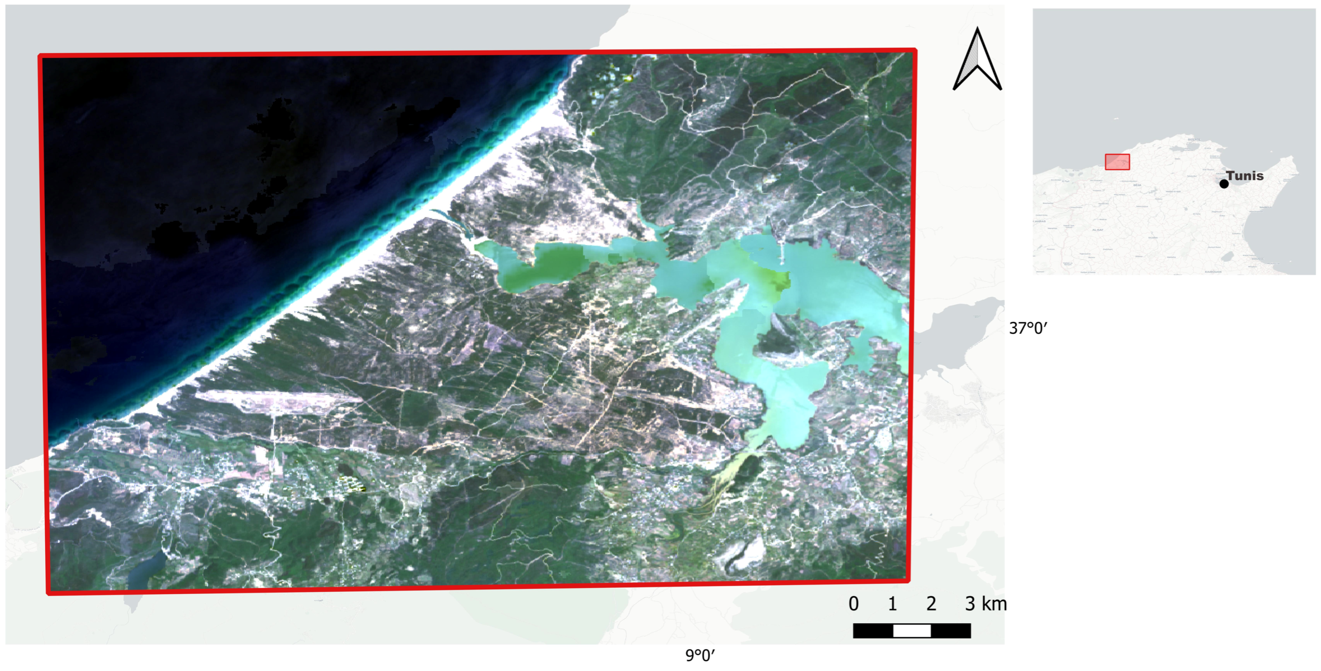
The study was conducted in the Zouarâa forest, established on the Ouchtata II coastal dunes, within the Tabarka–Nefza dune system in northwestern Tunisia (
Figure 1). The forest is located in the Zouarâa sector of the Nefza delegation, Béja Governorate (36°59′ N, 9°03′ E), and covers a total area of 4141 ha, including 448 ha of stone pine (
Pinus pinea) plantations. The remaining area is mainly occupied by maritime pine (
Pinus pinaster),
Acacia species, scattered juniper trees (
Juniperus spp.), and shrubland formations [
37].
The Zouarâa forest represents an entirely artificial forest ecosystem established on coastal dunes for sand stabilization purposes. Forest plantations, mainly composed of stone pine (
Pinus pinea), maritime pine (
Pinus pinaster), and
Acacia species, were established in 1960 with an initial planting density of approximately 2000 seedlings ha
−1 [
37]. The topography of the area is relatively heterogeneous, with most of the forest located on moderately steep terrain characterized by slopes ranging from 15 to 40%, while the remaining areas have gentle slopes generally below 10%. The mean elevation is approximately 100 m, with a predominant northwestern exposure [
37].
The climate is Mediterranean, characterized by mild winters and a prolonged summer dry period lasting five to six months. The mean annual temperature is 18.8 °C, and the average annual precipitation is approximately 934 mm [
69]. According to the bioclimatic classification, the region belongs to the lower humid bioclimatic zone with a mild winter variant. The area is also influenced by strong northwestern winds, particularly between December and late March [
37]. The soils are mainly composed of sandy aeolian deposits associated with coastal dunes, with some clay-silt alluvial deposits occurring locally [
37]. These environmental conditions have shaped the structure and functioning of this planted coastal forest ecosystem.
The areas affected by the fires were mainly composed of stone pine (Pinus pinea) stands, with some burned surfaces occupied by maritime pine (Pinus pinaster) plantations and scattered Acacia spp. areas.
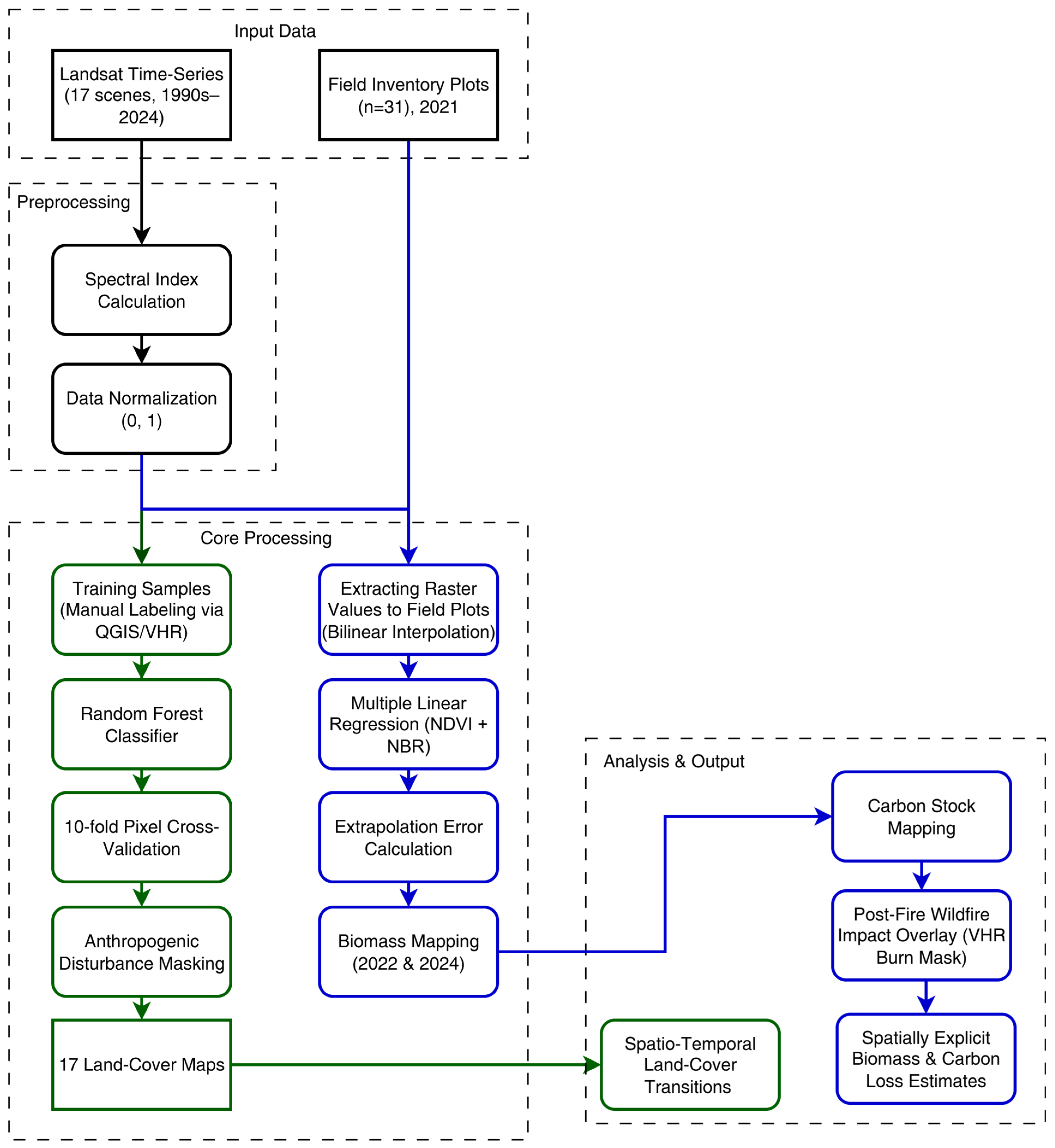
To ensure methodological transparency and reproducibility, the comprehensive research framework, including satellite data acquisition, preprocessing steps, land-cover classification, biomass modeling, and post-fire carbon loss estimation, is visually summarized in the schematic workflow diagram (
Figure 2).
2.2. Data
The study spans a 30-year period (1994–2024). Multispectral images from Landsat 5, 7, 8, and 9 were acquired at two-year intervals, resulting in a total of 17 images (
Table 1). These images were obtained using the Google Earth Engine (GEE) platform. During periods when multiple Landsat satellites were operational simultaneously, preference was given to newer missions. However, between 2003 and 2013, Landsat 7 images contained gaps due to the Scan Line Corrector (SLC) failure, so Landsat 5 data were used to compensate for missing bands.
To obtain cloud-free composites, Level-2 processed images with atmospheric correction from the spring months (March–May) were selected. This is justified by the fact that spring represents the peak phenological phase with optimal soil moisture, maximum chlorophyll activity, and full canopy development. This phenological peak provides the highest contrast and signal-to-noise ratio necessary to accurately differentiate between successfully recovering forest matrices, baseline stable vegetation, and stalled post-fire successional pathways. In contrast, severe summer droughts in the Mediterranean ecosystem cause widespread vegetation senescence and spectral flattening, masking the true signal of long-term vegetative recovery.
Cloud masking was applied using GEE’s maskL457sr (for Landsat 5 and 7) and maskL8sr (for Landsat 8 and 9) algorithms. After atmospheric correction, the panchromatic band (B8) was excluded from Landsat 5 and 7 datasets, while the cirrus (B9) and thermal infrared (B11) bands were excluded from Landsat 8 and 9 datasets. A median composite image was generated for the entire study period and exported as a GeoTIFF file with 30 m resolution, with each spectral band stored as a separate layer.
2.3. Vegetation Indices
To enhance classification accuracy, widely used vegetation indices were calculated from the spectral bands [
70,
71]. These indices combine multiple spectral bands to improve land cover discrimination.
Normalized Difference Vegetation Index (NDVI, [
72]) is used for vegetation identification:
Normalized Difference Water Index (NDWI, [
73]) designed to detect open water and distinguish it from vegetation and soil:
Normalized Difference Built-up Index (NDBI, [
74]) utilizes the reflectance features of built-up areas to distinguish them from land cover:
Normalized Differential Sand Areas Index (NDSAI, [
75]) used to detect sandy regions with low moisture content compared to other classes:
Normalized Differential Sand Dune Index (NDSDI, [
76]) aids in distinguishing sand dunes from other soil types:
Normalized Burn Ratio (NBR, [
39]) used to identify burned areas:
In Equations (1)–(6), Green-band 2 Landsat 5/7 (0.52–0.6 µm) or band 3 Landsat 8/9 (0.525–0.6 µm); Red-band 3 Landsat 5/7 (0.63–0.69 µm) or band 4 Landsat 8/9 (0.64–0.67 µm); NIR-band 4 Landsat 5/7 (0.76–0.9 µm) or band 5 Landsat 8/9 (0.85–0.88 µm); SWIR1-band 5 Landsat 5/7 (1.55–1.75 µm) or band 6 Landsat 8/9 (1.57–1.65 µm).
2.4. Research Methods
Based on the land cover distribution in the study area, seven classes were selected as the most representative: Water, Sand, Urban, Forest, Shrubs, Agriculture, and Bare Soil. The Urban class encompasses all anthropogenic structures, primarily buildings and roads. The Shrubs class includes low, sparse vegetation within forests and mechanical dune stabilization plants along the coast. Bare soil refers to exposed soil surfaces devoid of vegetation. The Burned class was also added to the set to identify burned trees in the 2023 forest fire.
To disentangle vegetative recovery from infrastructure-driven land conversion, we defined a set of anthropogenic masks: (i) the Sidi El Barrak Dam reservoir, delineated from the Water class and verified against historical construction records (1990–2000); (ii) the Tabarka–Ain Draham International Airport (240 ha, inaugurated 1992), digitized from VHR imagery; and (iii) all pixels classified as Water and Urban. Pixels falling within these masks were excluded from the “natural stabilization” analysis. Sand-to-vegetation transitions occurring outside these masks were attributed to reforestation and natural succession, while sand-to-water and sand-to-urban transitions were classified as anthropogenic. This approach allowed us to quantify the relative contribution of each driver to the observed sand decline.
Satellite image classification was performed using the Random Forest machine learning method from the Python 3.11 scikit-learn library, which has demonstrated robust performance in similar studies [
71,
77,
78]. The model was configured with 500 trees, while other parameters retained their default values. Classification quality was assessed using a standard 10-fold cross-validation process based on a randomized pixel-level split of the digitized polygons. To ensure a balanced and structurally rigorous evaluation across classes of varying spatial extents, the precision, recall, and F1-score were computed using the macro-averaging method at each cross-validation step. The final metrics were derived as the mean values across all 10 iterations. Feature importance was evaluated using the Random Forest’s built-in feature importance method.
It should be noted that a pixel-level split preserves a degree of spatial autocorrelation between nearby pixels originating from the same training polygon. This approach was selected to maximize the model’s capacity to capture the localized, highly heterogeneous spectral signatures of dynamic classes (such as shrubs and shifting agriculture). While this localized training methodology yields an optimistic baseline accuracy, it ensures the highest spatial fidelity for the resulting multi-temporal land-cover maps within the specific geographic boundaries of the study area.
A different training sample was created for each year of the study period. Manual labelling was performed in QGIS 4.2 by delineating polygons for each class on the satellite imagery. The primary reference data were very-high-resolution (VHR) images from Google Earth, with a spatial resolution of ≤0.5 m, acquired as close as possible to the corresponding Landsat overpass date. For years without VHR coverage, the closest available date (±1 year) was used, and land cover stability was visually verified using temporal series of false-color composites. On average, 250 polygons were annotated per year, with a minimum of 30 polygons per main class to capture spectral heterogeneity.
Table 2 provides a detailed baseline distribution of the digitized training polygons and their corresponding total pixel counts for the representative year of 2024, reflecting the standard sampling structure, density, and class proportions maintained throughout the entire multi-temporal dataset.
To address the temporal uncertainty arising from potential mismatches between Landsat scenes and VHR imagery, a two-step validation approach was implemented. For years with adequate data availability, a strict seasonal window filtering was applied, selecting VHR images exclusively within the summer season to match the peak phenological phase of the corresponding Landsat data. In cases where high-resolution imagery was unavailable during this optimal seasonal window—particularly for earlier years in the study period—temporal uncertainty was mitigated through historical trajectory analysis and multi-temporal composites. For highly dynamic classes such as agriculture, shrubs, and burned areas, land-cover transitions were cross-verified using long-term time-series trends to ensure that short-term phenological shifts or temporary disturbances were not misclassified as permanent land-cover changes.
2.5. Biomass and Carbon Losses Caused by Fire in Restored Ecosystems
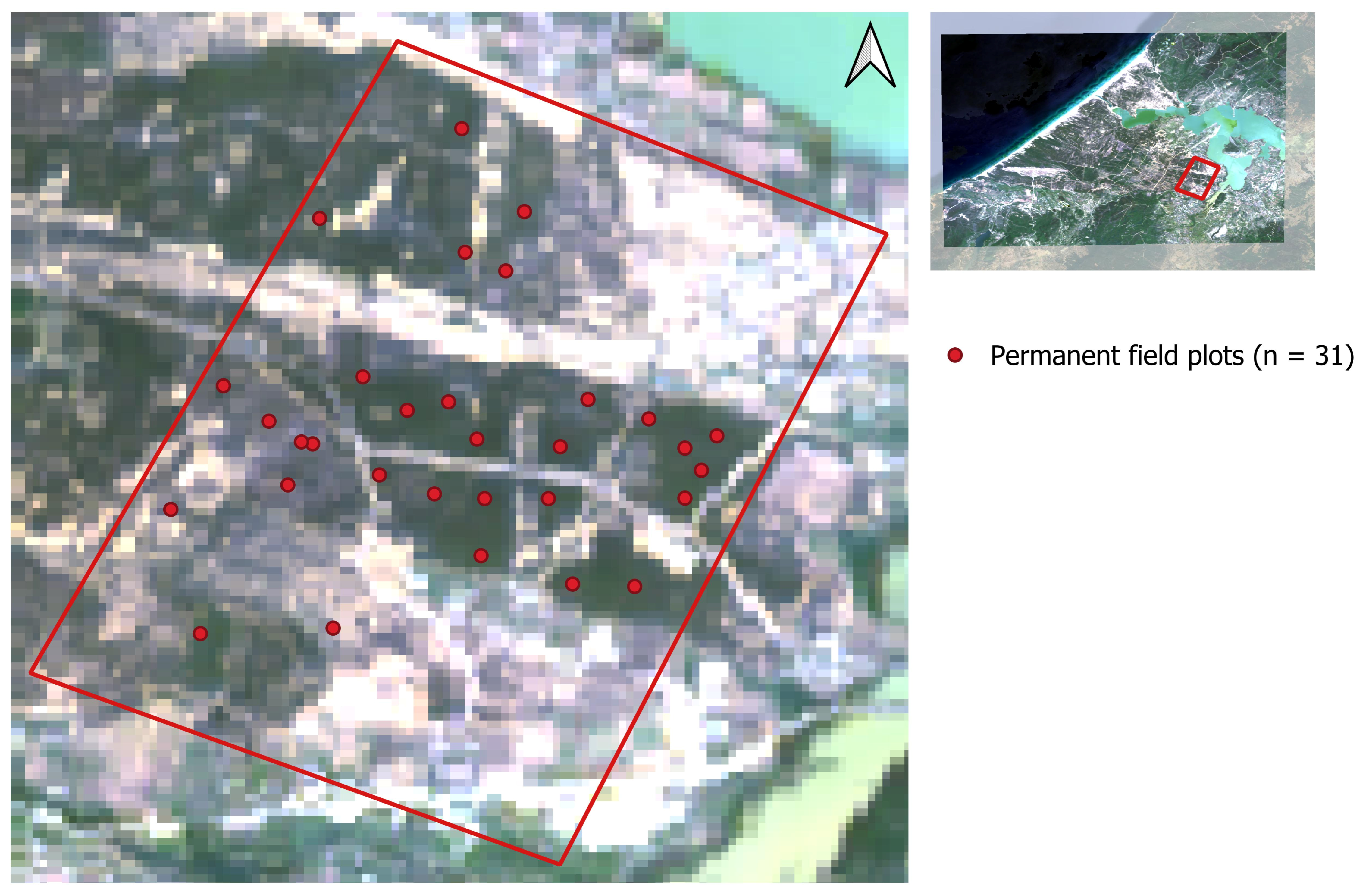
To estimate fire-induced biomass losses, we conducted a field survey in May 2021, approximately two years before the 2023 wildfire, within the area that would subsequently be affected by the fire. A total of 31 permanent plots (20 m × 20 m each) were established using a stratified random design to capture the variability in tree density, diameter classes, and micro-topography. All plots were georeferenced using WGS 1984 decimal degree coordinates (
Figure 3). Within each plot, we recorded the total number of trees, diameter at breast height (DBH, 1.3 m) for all individuals with DBH ≥ 5 cm, and total tree height.
Aboveground biomass (AGB) per tree was estimated using the species-specific allometric equation developed by [
79,
80,
81,
82,
83] for
Pinus pinea:
where DBH = diameter at breast height (cm), measured at 1.3 m above the ground, H = total tree height (m), and a, b, and c = species-specific allometric coefficients obtained from the selected allometric model [
79,
80,
81,
82,
83].
Plot-level AGB (t ⋅ ha
−1) was calculated as the sum of individual tree biomass divided by plot area, then converted to carbon using a locally derived conversion factor of 0.472 [
84,
85]. To address the spatial scale mismatch between the 20 × 20 m field inventory plots and the 30 m spatial resolution of the Landsat 9 pixels, a rigorous spatial extraction workflow was implemented. The field plots were represented as a point vector layer based on the GPS coordinates captured at the exact center of each plot. To bridge the scale gap, we utilized bilinear interpolation during value extraction to compute a continuous weighted surface from the four neighboring pixels. Furthermore, all 31 permanent plots were established within homogeneous forest stands, ensuring that even with minor sub-pixel spatial misalignments, the extracted satellite signals remained highly representative of the localized biophysical biomass parameters measured on the ground.
To extrapolate the field plot measurements to the entire study area, a parametric multiple linear regression model was developed using the permanent inventory plots (pre-fire baseline) as ground truth. To avoid overparameterization and ensure the biophysical validity of temporal extrapolation given the sample size, the predictor suite was optimized and restricted strictly to two foundational spectral indices: the NDVI and NBR. Prior to model calibration, all input features were normalized to a strict (0, 1) range. The resulting predictive equation for continuous aboveground biomass mapping is formulated as follows:
The calibrated regression model demonstrated a robust and realistic baseline performance within the training matrix, yielding a coefficient of determination R2 = 0.51 and a root-mean-square error RMSE = 45.38 t ⋅ ha−1. Both positive coefficients align with fundamental ecological principles, where higher canopy greenness and forest moisture status scale with elevated timber volumes.
To quantify the uncertainty associated with projecting this pre-fire model onto the ecologically altered post-fire landscapes without supplementary ground data, a pixel-level standard error of prediction SEpred was calculated. The mean extrapolation error across the burned area was estimated at ±53.41 t ⋅ ha−1. The final predictive model was applied to cloud-free Landsat 9 composites from 2022 and 2024 to produce continuous post-fire biomass maps. Carbon maps were subsequently derived by multiplying the biomass maps by a standard conversion factor of 0.472. The spatial difference between the multitemporal maps provided explicit, verified estimates of biomass and carbon losses attributable to the fire disturbance.
3. Results
3.1. Evaluation of Accuracy and Feature Importance
The classification achieved high performance metrics: Average accuracy = 98.03%, Precision = 0.9456, Recall = 0.9262, F1-score = 0.9367. While these metrics are presented for the representative year of 2024 to maintain manuscript conciseness, independent accuracy assessments were rigorously conducted for each of the 17 analyzed Landsat scenes across the 30-year study period. The classification performance demonstrated temporal consistency and stability across all sensors, with the multi-temporal overall accuracy fluctuating within a narrow margin from 96.8% to 98.4%.
Feature importance analysis (
Table 3) revealed that vegetation indices contributed minimally to the model. The NDSDI index was the least influential in both Landsat datasets (5&7 and 8&9). Excluding vegetation indices resulted in marginally lower performance (accuracy = 97.81%, F1 = 0.9779). The most important spectral bands were NIR, SWIR1, and Green, with the Green band ranking second in Landsat 5&7 and third in Landsat 8&9. Among vegetation indices, the NDWI (water index) exhibited the highest importance in both datasets.
To avoid redundant data presentation across the 30-year study period, the feature importance analysis is explicitly presented using two baseline representative years: 2012 for the Landsat 5/7 sensor generation and 2024 for the Landsat 8/9 generation. These specific years were selected as reference models because they capture the full operational spectrum of the respective sensors under stable environmental conditions. Cross-examination of the remaining years revealed that the relative ranking and contribution weights of the spectral bands and vegetation indices remained highly consistent over time. Consequently, the reported values for 2012 and 2024 serve as robust multi-temporal proxies, demonstrating that the structural importance of the spectral features remained stable throughout the long-term monitoring period and was not significantly altered by inter-annual vegetative fluctuations.
3.2. Land Area Changes by Categories
The spatio-temporal analysis of land-cover changes revealed substantial landscape transformations over the 30-year study period (
Table 4;
Figure 4), highlighted by a 42.9% net reduction in coastal sand dunes from 2209 ha to 1262 ha. We observed a significant expansion of the urban area within the study zone, which increased from 50 ha in 1994 to 325 ha in 2024, which is 550% increase and indicates strong anthropogenic pressure on the coastal zone. Water bodies increased by +18.5% due to the construction of dams in the region. Bare soil and agricultural land also expanded considerably (+44.9% and +36.8%, respectively). In general, the area of agricultural land shows trends of decreasing or increasing depending on rainfall, as most agricultural practices are seasonal and rely heavily on precipitation, particularly cereal cropping and market gardening. Shrub cover, an important component of dune vegetation, declined by a quarter (–25.7%), while forest areas increased slightly from 10,639 ha in 1994 to 11,078 ha in 2024 (+4%).
3.3. Dune Stabilization Results
The dynamic of dune area reduction is driven by two distinct opposing forces: active ecological stabilization through vegetation expansion and direct anthropogenic modifications.
Environmental stabilization efforts emerged as the dominant driver of sand dune contraction, transforming 54% (
Table 4) of the initial unstable sand landscape into stabilized green infrastructure (Forest and Shrub classes). A total of 996 ha (45.1%) of moving sand dunes successfully transitioned into shrubland. Ecologically, this dominant transition trajectory signifies that the initial artificial interventions triggered a secondary progressive succession; by effectively arresting aeolian sand transport and altering the surface roughness, the plantations created a sheltered microclimate that facilitated the colonization and expansion of resilient native Mediterranean shrub communities. An additional 196 ha (8.9%) developed into permanent forest cover, validating the long-term success of intentional tree-planting initiatives, particularly plantations of stone pine (
Pinus pinea) and
Acacia cyclops, which were established in the region. The development of this stable forest canopy represents a critical ecological shift, transitioning the landscape from a hyper-arid, nutrient-poor baseline to an active carbon-sink matrix characterized by accelerated litter decomposition, initial topsoil formation, and enhanced moisture retention capabilities. This represents the primary stabilizing pathway, indicating effective sand-fixation projects and natural ecological succession. A minor fraction of 14 ha (0.6%) was converted to agricultural lands.
Beyond vegetative recovery, physical engineering and urban sprawl directly altered the dune topography, accounting for 14.6% of direct sand area loss. Within the study area, the Sidi El Barrak Dam represents a major water retention structure that created a large reservoir in the region. Its construction began in the 1990s and was completed in the early 2000s, which explains the increase in water areas observed since 2000. Due to the establishment of the dam, 291 ha (13.2%) of previous coastal sand dunes were physically submerged, contributing to a massive net growth of the total water surface area from 10,159 ha to 12,043 ha. Urban and infrastructure development directly paved over 32 ha (1.45%) of the sand matrix, marking an irreversible artificial footprint on the dune boundaries.
Despite a heavy net loss, the sand category received secondary inputs totaling 593 ha from surrounding landscapes. Notably, a significant 463 ha of shrubland degraded back to exposed moving sand, serving as a key indicator of post-fire ecosystem vulnerability or intense drought impacts. This localized environmental regression triggers a well-documented feedback loop in coastal systems: the loss of vegetative canopy eliminates surface roughness, thereby reactivating aeolian sand transport and accelerating the deflation of the nascent, fragile topsoil. This structural breakdown of the stabilized matrix is primarily driven by the compounding effects of unauthorized wood extraction, recurrent forest fires, and localized anthropogenic pressures, exacerbated by the synchronous senescent phase of dune-fixing species. Specifically, plantations of Acacia species exhibit a relatively short ecological lifespan of 15 to 25 years; their widespread natural mortality, coupled with a lack of spontaneous regeneration under arid conditions, left large tracts of sandy substrate directly exposed to wind erosion. Concurrently, combined conversions from degraded farmland (65 ha) and unmanaged bare soil (42 ha) highlight active localized land degradation risks, where poorly managed open spaces rapidly transition back into highly mobile sand fields.
To isolate the biophysical effect of active afforestation from confounding infrastructure development, we analyzed a subset of the study area where no major infrastructure was built between 1994 and 2024. In this ‘stabilization-only zone’ (
Table 5), sand decreased from 1902 ha to 672 ha (−64.7%), while Forest increased from 1516 ha to 2038 ha (+34.4%) and Shrubland from 2305 ha to 2519 ha (+9.3%). These significant shifts occurred entirely in the absence of dam or airport footprints, providing unequivocal empirical evidence that targeted stabilization interventions successfully immobilized active mobile dunes (landscapes otherwise characterized by unrestricted sand transport, sparse vegetation cover, and high aeolian activity). Crucially, the magnitude of sand contraction in this control zone (−64.7%) was substantially higher than that observed across the entire study area (−42.9%). From a landscape ecology perspective, this divergence confirms that large-scale infrastructure projects induce severe habitat fragmentation and alter local wind patterns, which artificially masks and suppresses the true operational success of vegetative recovery. In contrast, the unfragmented stabilization zone allowed for uninterrupted ecological succession, reinforcing the premise that under continuous canopy cover, the engineered forest matrix achieves its maximum potential in mitigating desertification and consolidating shifting coastal substrates.
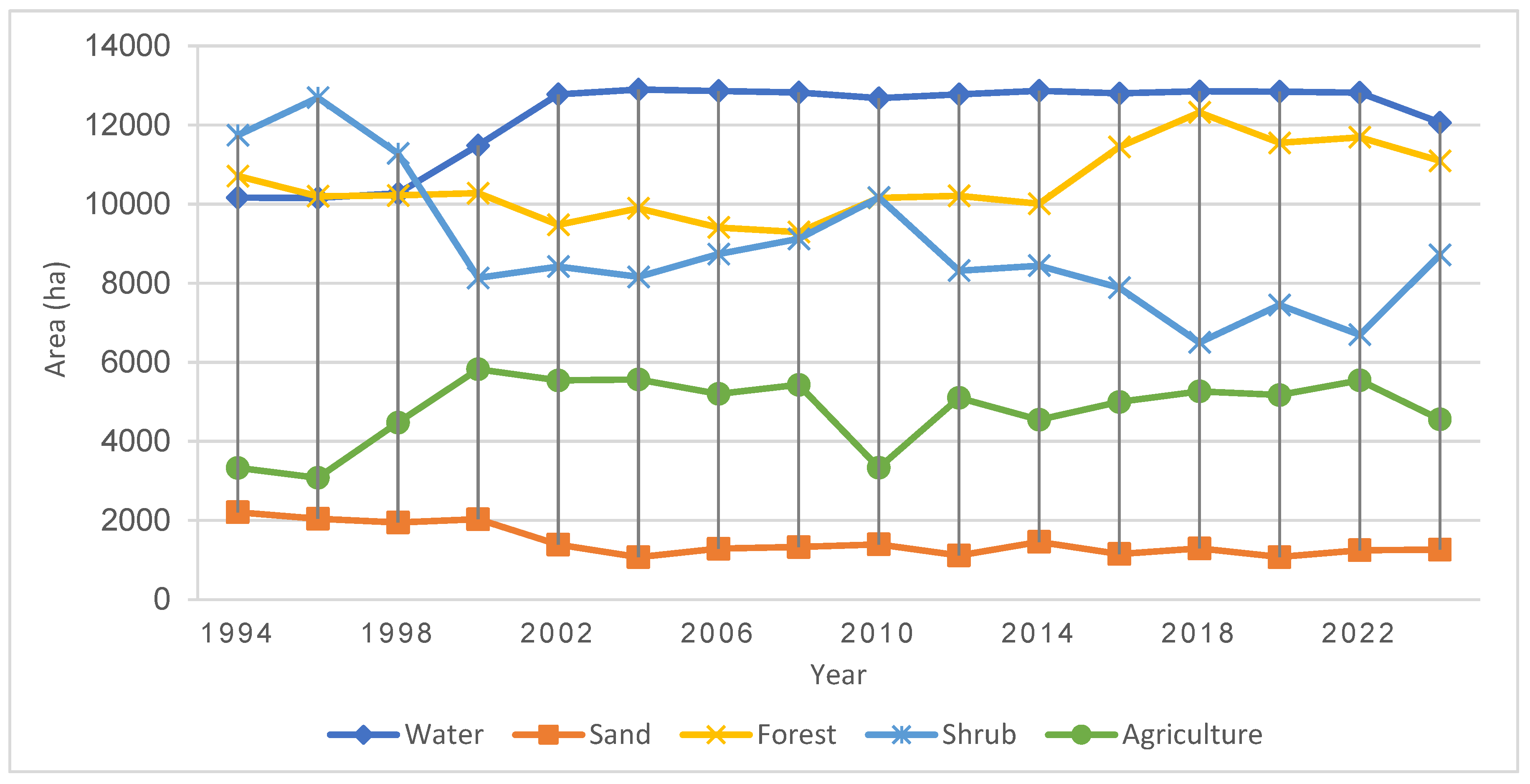
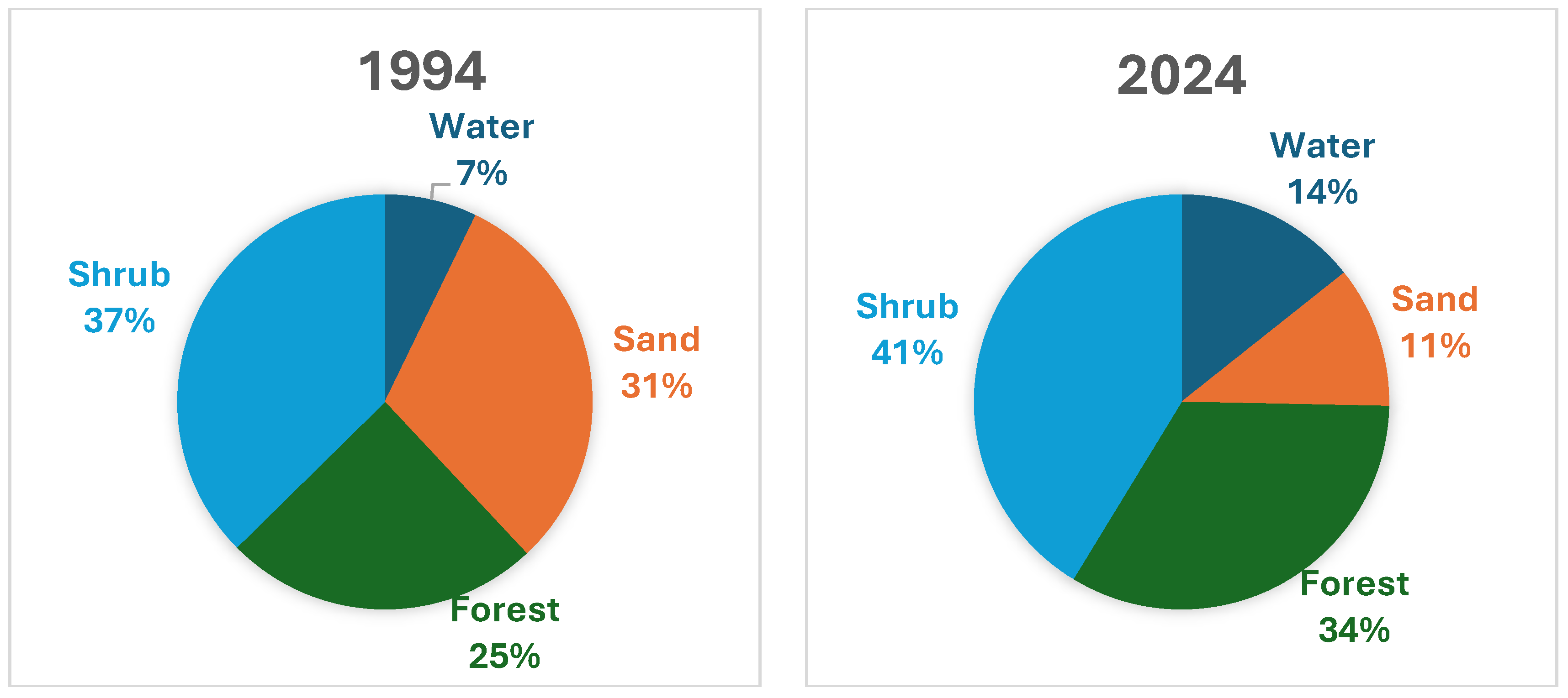
Figure 5 illustrates the relative proportions of the four dominant classes (Water, Sand, Forest, and Shrub) revealing a notable reduction in sandy areas concurrent with expansions in forested, shrubland, and water zones.
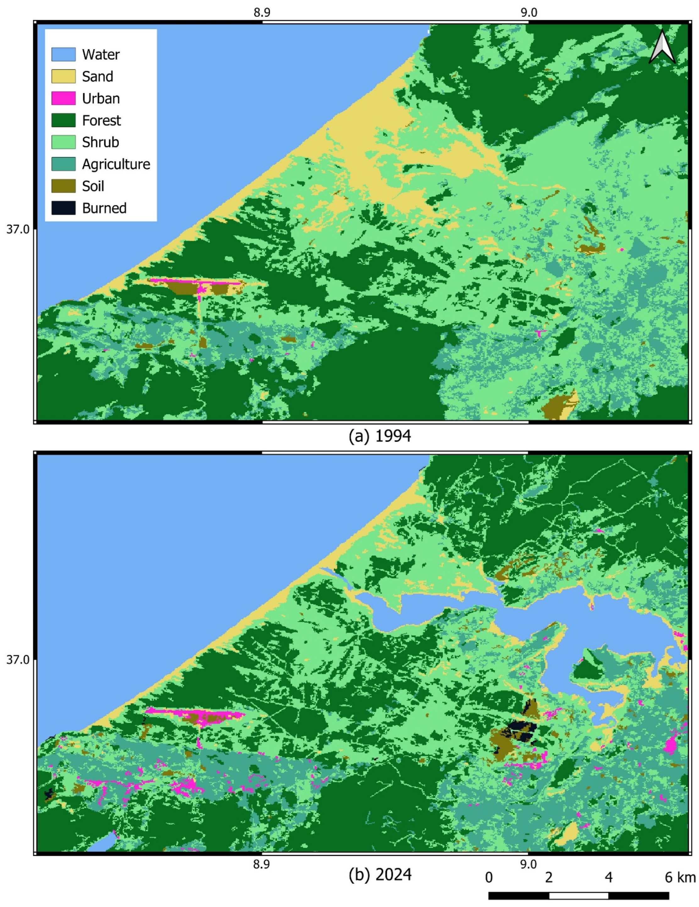
Figure 6 displays the land cover classification maps for the initial (1994) and final (2024) years of the study period, highlighting spatial and temporal transformations.
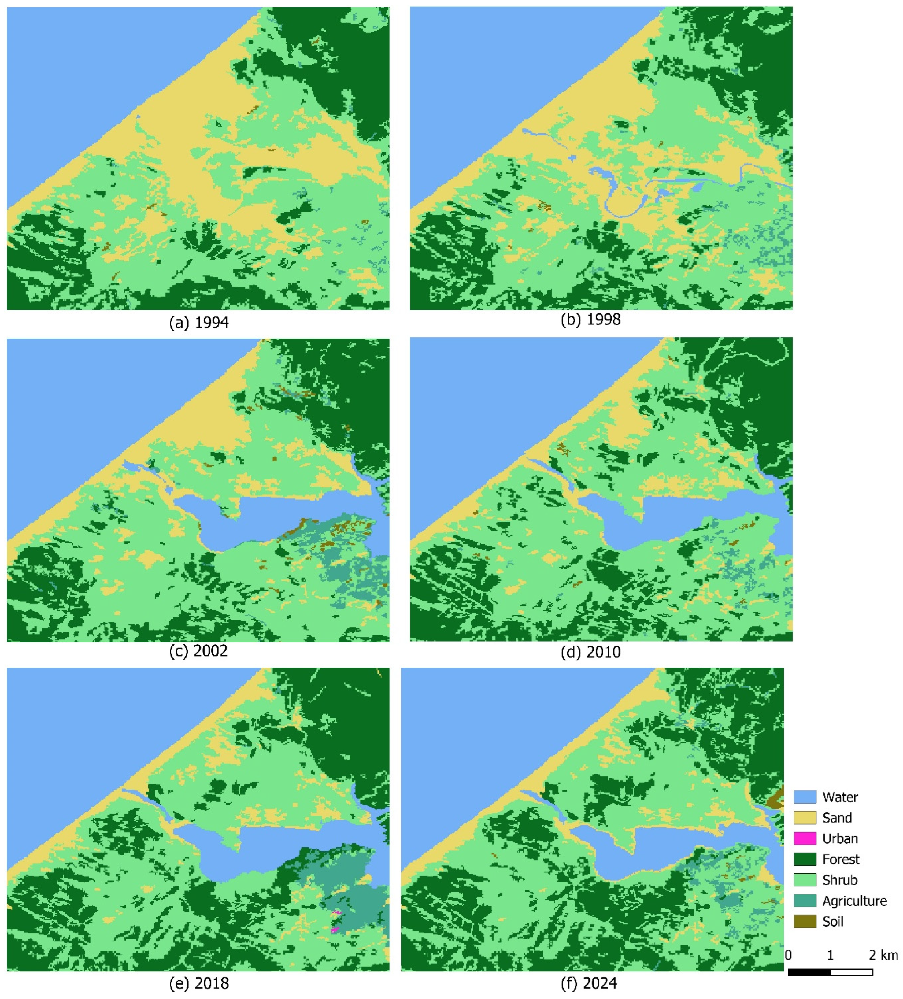
Figure 6 and
Figure 7 show that the construction of the Sidi El Barrak Dam in 2000 on sand dune areas required substantial reforestation efforts around the reservoir. These interventions aimed to stabilize the dam banks, increase the dam’s lifespan, and prevent siltation caused by sediment accumulation. The main tree species used for reforestation to protect the dam and surrounding forest areas were stone pine (
Pinus pinea) and maritime pine (
Pinus pinaster), while shrub species included
Acacia cyclops and
Acacia cyanophylla. We also observed a marked expansion of urban areas, particularly following the construction of the airport.
The Tabarka-Aïn Draham International Airport, located in the northwest of our study area, was inaugurated in 1992 and covers an area of 240 ha. It was established within forested areas, including reforested zones and stabilized dunes. We observed that urban areas have developed all around the airport, driven by tourism activities and the creation of employment in the region. Many agricultural lands have been converted for residential construction by the local population, contributing to the expansion of urban zones surrounding the airport.
Figure 7 illustrates the installation of the dam on sand dune areas. This process lasted approximately ten years, from 1990 to 2000. The dam occupied a substantial portion of the sand dune system, and reforestation activities were intensified to stabilize the surrounding dunes. These interventions were mainly implemented around the dam, within depression areas, and along the hydrographic network that channels rainfall runoff toward the reservoir. The primary objective was to reduce sand encroachment and sedimentation within the dam.
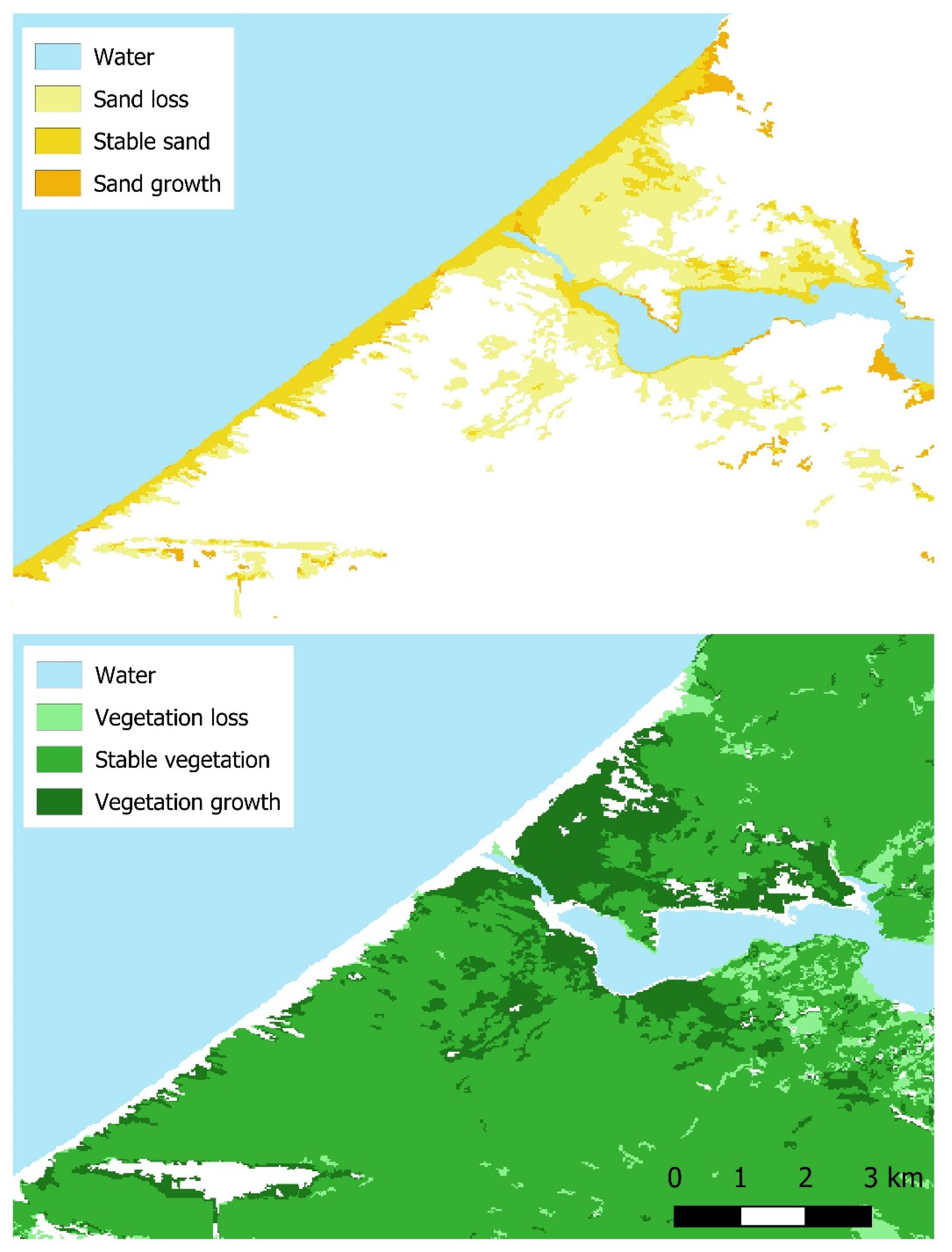
Figure 8 and
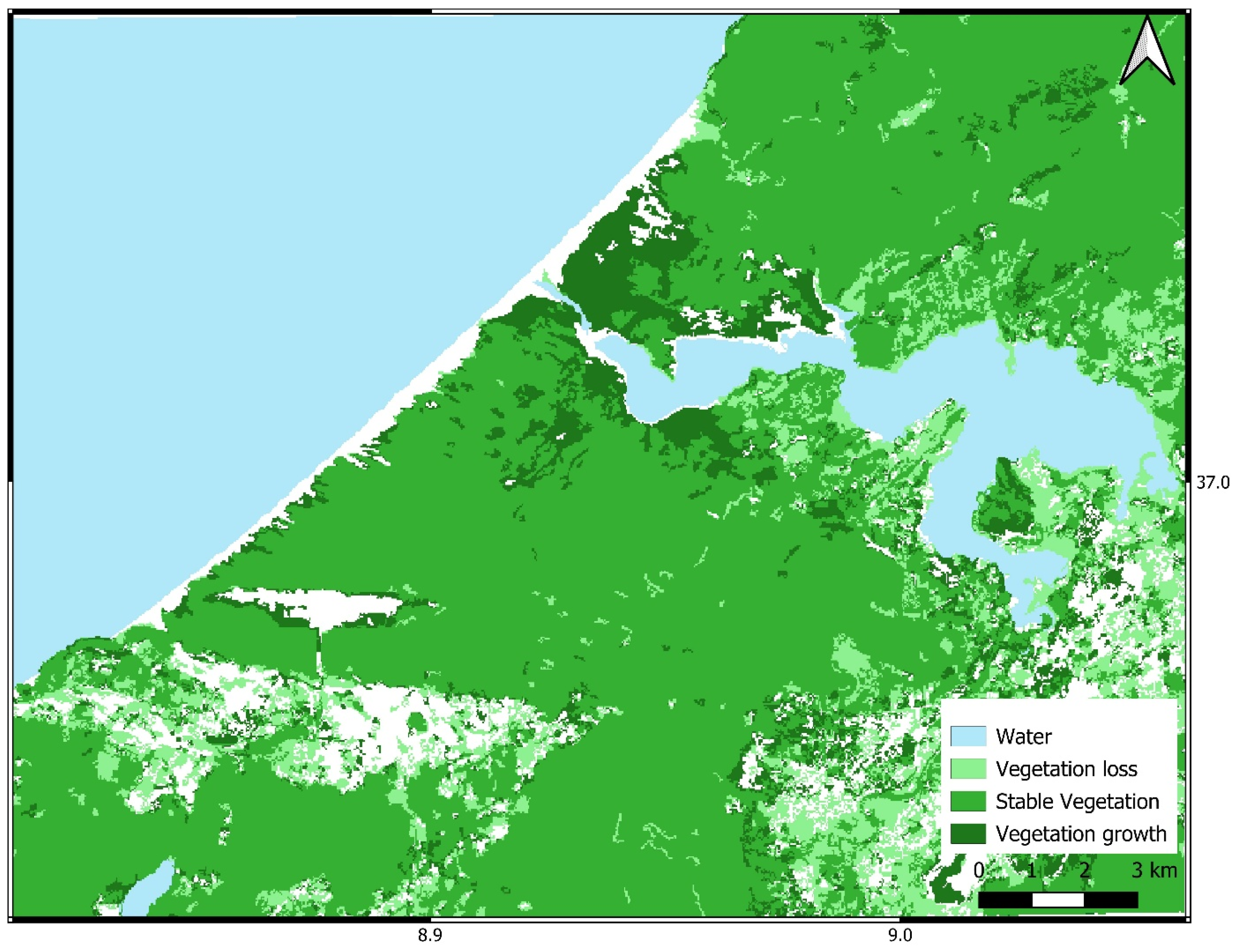
Figure 9 present the dynamics of sand and vegetation cover from 1994 to 2024, analyzing changes in both the coastal fragment and the entire study area. Loss is the transition from the target class to another class, growth is the transition from other classes to the target class, and stable state is the persistence of the original land cover class.
A significant portion of the lost dunes now corresponds to the area occupied by the dam, which was constructed between 1990 and 2000. The figures also indicate that vegetation loss occurs primarily around urban areas, which can be explained by the expansion of urban zones into other land types, including uncultivated land, agricultural fields, and forested areas. Stable vegetation consists of dune-fixation plantations established since the 1960s, as part of reforestation efforts carried out after independence in 1956, when the region experienced severe sand encroachment on homes and successive road closures. Vegetation growth refers to both naturally regenerated vegetation and reforestation associated with dam construction, mainly composed of pine and Acacia species.
The quantified area reductions in the active sand class and corresponding increases in forest and shrub cover directly support Objective (i) and (ii), demonstrating that the stabilization practices effectively altered the landscape matrix. From an ecological perspective, these transitions signify that the established forest plantations successfully modified the local microclimate and soil conditions, allowing native shrub species to encroach and further stabilize the moving sand substrate.
3.4. Dynamics of the Urban and Agriculture
Between 1994 and 2024, urban expansion occurred primarily at the expense of shrubland, agriculture, and sand cover, while forest loss was negligible (
Table 6). We observed that the construction and expansion of houses by the local population occurred largely on sand dunes, where residents cleared dune-stabilizing plantations to build their homes, thereby inducing localized soil reactivation and severe edge effects. Urban expansion has also affected the shrubland stratum, particularly after 2010, a period marked by political instability, weak law enforcement, and numerous infractions that led to severe habitat fragmentation. Peak shrubland losses amounted to 59.5 ha (2016–2018) and 61.9 ha (2020–2022).
Agriculture emerged as the second-largest contributor, with accelerating losses in recent intervals: from 30 ha in 2016–2018 to 43 ha in 2018–2020, 36.2 ha in 2020–2022, and peaking at 48.1 ha in 2022–2024, indicating growing pressure from urban sprawl on agricultural land. Sand areas were also consistently converted to urban uses, with losses increasing markedly after 2010, peaking at 34 ha in 2014–2016 and remaining high (22–26 ha) in subsequent periods. In contrast, forest contributed minimally to urban expansion throughout the study period, with most intervals showing negligible or zero loss (0–0.14 ha), and only a single interval (2018–2020) recording 1.8 ha. Overall, the table demonstrates that urban expansion in the study area has primarily been realized through the conversion of shrubland, agricultural land, and sand-covered surfaces, with the intensity of conversion accelerating notably after 2010, permanently disrupting the connectivity of the coastal ecosystem matrix.
The shrubland was by far the dominant source of agricultural expansion throughout the entire study period (1994–2024). Shrubland conversion peaked in two distinct intervals: 1998–2002 (2365.3 ha) and 2010–2012 (2219.7 ha), with consistently high values exceeding 556 ha in all intervals, indicating a sustained and massive transformation of shrub-dominated ecosystems into cropland. Forest also played a substantial role, with notable peaks in 1994–1998 (201.29 ha), 2010–2012 (213.8 ha), 2018–2020 (399.5 ha), and 2020–2022 (395 ha). The acceleration of forest conversion after 2018 is particularly striking, suggesting increased pressure on wooded areas during the most recent decade. Sand contributed the least overall, but a remarkable peak occurred in 2014–2016 (263.2 ha), indicating a temporary but intense episode of dune conversion to agriculture that caused localized coastal de-stabilization.
The temporal pattern reveals two phases of particularly intense agricultural expansion: the early period (1994–2002) driven primarily by shrubland and forest, and the period after 2010, characterized by renewed high pressure on shrubland and forest, alongside significant contributions from sand and bare soil. Overall, agricultural encroachment has been a major driver of landscape change, disproportionately affecting shrubland ecosystems while also making substantial inroads into forest and, at times, coastal sand deposits.
3.5. Post-Fire Carbon and Biomass Loss
The July 2023 wildfire affected approximately 120 ha of restored coastal dune vegetation. This event provided a rare opportunity to quantify fire-induced biomass and carbon losses in a non-pyrogenic ecosystem. The impact of fire on the restored coastal dune ecosystem is documented in
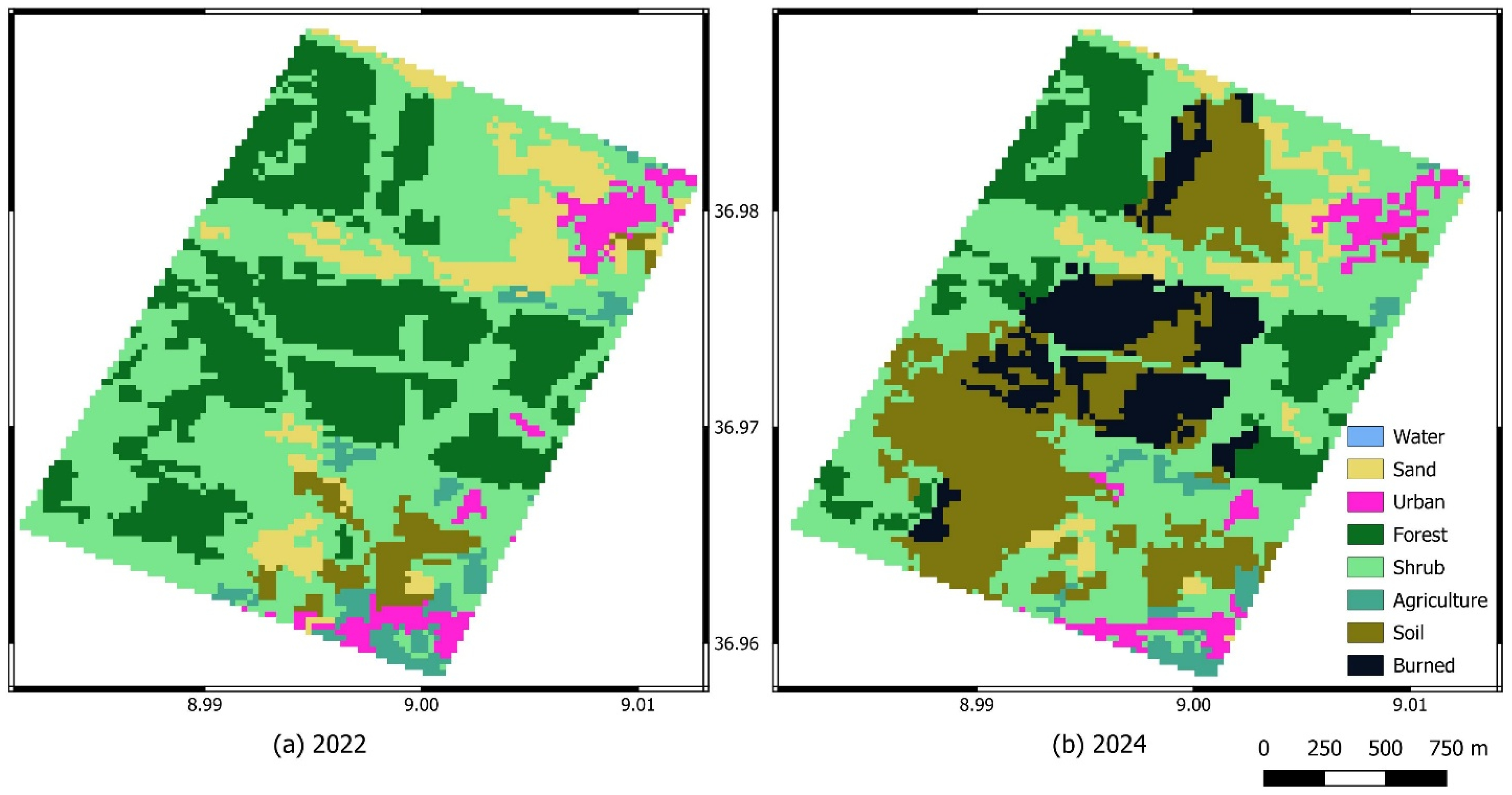
Figure 10, which presents a visual comparison of the study area before and after the fire event, showing extensive burning of forest and shrubland.
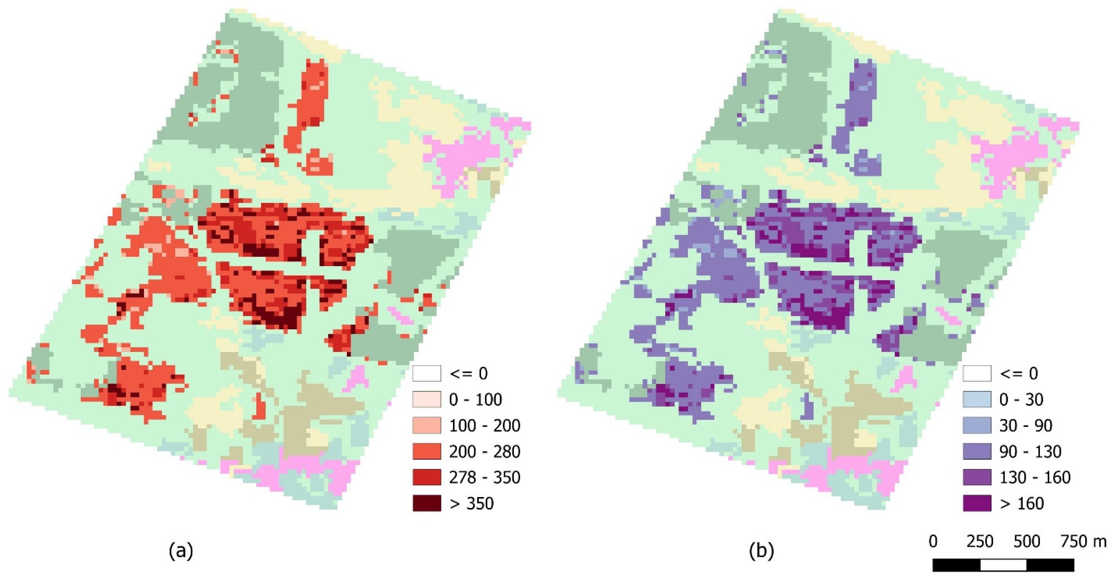
Figure 11 provides a quantitative estimate of the immediate ecological losses, indicating that biomass losses reached 264.19 t ⋅ ha
−1, while carbon losses amounted to 124.17 t ⋅ ha
−1.
Table 7 complements these findings by detailing land cover changes between 2022 (pre-fire) and 2024 (post-fire). Before the fire, the area was characterized by 171 ha of forest and 239 ha of shrubland, with only 20 ha of bare soil. Following the fire, forest cover dramatically decreased to 69 ha (a loss of 102 ha), and shrubland declined to 197 ha (a loss of 42 ha). Concurrently, bare soil expanded from 20 ha to 131 ha, representing an increase of 111 ha, which directly corresponds to the area where vegetation was completely removed by fire. Additionally, 63 ha were classified as burned in 2024, indicating areas that remain visibly affected but not yet converted to bare soil.
These multi-temporal biomass and carbon dynamics address Objective (iii), showing that while the wildfire caused an immediate and severe regression in aboveground carbon stocks, the structural foundation of the afforested stands accelerated post-fire soil protection, preventing a complete reversal back to active sand dunes.
The observed land-cover transitions transcend simple geographical area shifts and reveal distinct successional trajectories driven by engineered stabilization. The continuous conversion of active sand dunes into forest and shrub matrices highlights the long-term effectiveness of afforestation, which successfully arrested soil erosion and initiated topsoil development. From an ecosystem function perspective, these structural transitions signify a massive shift in ecosystem services—moving from an unstable, low-productivity landscape to an active carbon-sequestering matrix. Although the severe fire disturbance disrupted this trajectory, causing localized but intense biomass and carbon pullbacks, the multi-temporal trends demonstrate that the surrounding forest matrix maintains high functional resilience. The rapid post-fire stabilization and signs of vegetative recovery in subsequent years suggest that while the original dune ecosystem was permanently altered by human intervention, the resulting engineered forest matrix provides stable, long-term carbon storage and soil protection capabilities.
4. Discussion
4.1. Assessment of Coastal Reforestation
It is important to clarify that this study evaluates the long-term effectiveness of reforestation-based dune stabilization and subsequent vegetative recovery, rather than ecological restoration in its strictest sense. True ecological restoration typically aims to recover the composition and functions of the original, highly dynamic coastal dune ecosystem. In contrast, the engineered afforestation practices analyzed here prioritize sand immobilization, soil development, and rapid carbon sequestration. While our evaluated indicators (such as biomass accumulation and canopy closure) confirm the high structural and technical success of these stabilization efforts, they simultaneously reflect a permanent transition from an open dune system to a managed forest matrix, rather than the return to a historical reference ecosystem.
Our results show that vegetation in dune systems (grasses, shrubs, and trees) plays a fundamental role in stabilizing dunes and reducing wind-driven sand transport. This finding is consistent with [
32], who demonstrated that dense vegetation on foredunes not only limits erosion but also promotes organic matter accumulation and pedogenesis processes, thereby strengthening coastal ecosystem stability. Furthermore, the evolution observed in our study area highlights an overall improvement in ecosystem stability following reforestation actions. This positive trend, marked by increased stabilization over the last decade, is consistent with Motte [
29], who emphasized the importance of reforestation efforts initiated in the 1960s to ensure long-term sand fixation while also generating significant economic and social benefits, particularly in terms of timber production and employment.
However, despite these improvements, our observations still indicate a persistent anthropogenic influence, particularly through dam construction and the presence of an airport within restored areas. On one hand, sand cover decreased substantially by 42.9% between 1994 and 2024, indicating effective reduction in mobile sand surfaces—a primary goal of the stabilization interventions initiated by the Tunisian Forest Services [
35]. On the other hand, shrubland declined by 25.8%, suggesting that agricultural encroachment and fire have negatively impacted shrub communities. Thus, vegetative recovery has succeeded in stabilizing sand but has not fully reversed the loss of native shrub vegetation. This situation aligns with the findings of Calafat [
86], who showed that even after stabilization, dune systems may retain an ecological signature linked to past human disturbances. The building of the Sidi El Barrak dam on forested and agricultural areas has modified the natural functioning of the system, in agreement with Kassouk [
32], who reported that dam development in coastal zones disturbs river dynamics and reduces sediment transfer toward the cape, resulting in sediment buildup along the shoreline.
Moreover, the dynamics observed at our site, characterized by a transition toward aggradation processes and a partial recovery of the typical dune vegetation composition, reflect the partial success of stabilization efforts. However, this positive trend must be interpreted with caution.
Table 6 reveals that urbanization directly consumed sand areas (e.g., 34 ha in 2014–2016), meaning that part of the sand reduction is attributable to land take rather than ecological stabilization. Nevertheless, the overall trajectory remains consistent with successful long-term dune fixation. As highlighted by Montoni [
87], the degree of recovery strongly depends on the initial state of the site, the level of degradation, and the time elapsed since the cessation of anthropogenic activities, which explains the spatial and temporal variability observed in our study area. In this context, our findings confirm that vegetative recovery cannot be fully effective without sustainable and continuous coastal management. Indeed, Della Bella [
2] emphasize the urgent need to implement sustainable management measures to address increasing pressures on coastal ecosystems, particularly climate change and human activities. Finally, our results also confirm that geomorphological and ecological characteristics strongly control dune dynamics and their regeneration capacity. This is consistent with Pinna et al. [
4], who show that the presence, typology, and development of dunes are closely dependent on these environmental factors. Moreover, Prisco [
28] highlight the importance of guiding coastal dune management toward the conservation of threatened habitats characterized by high biodiversity, in order to ensure their long-term preservation.
The observed transitions from sand to shrubs and sand to forest should be interpreted as indicators of dune stabilization and vegetative recovery at the landscape scale, rather than as direct evidence of the individual ecological mechanisms involved. Indeed, remote sensing data allow the quantification of spatiotemporal changes in vegetation cover and land-use patterns but cannot directly identify the biological processes responsible for these transformations, such as vegetation succession, species dynamics, or biotic interactions. Nevertheless, within the context of the study area, the progressive reduction in sandy surfaces combined with the expansion of forest and shrub formations is consistent with the objectives of historical dune fixation programs based on Pinus sp. and Acacia spp. Therefore, these land-cover trajectories represent indirect but robust evidence of improved vegetation cover and reduced dune mobility over a three-decade period. This interpretation is further supported by the analysis of the stabilization-only zone, where major anthropogenic infrastructures were excluded, suggesting that the observed changes are more strongly associated with reforestation success and natural stabilization processes.
4.2. Assessment of Biomass Production in Stone Pine (Pinus pinea) Coastal Dunes in Tunisia
Based on dendrometric measurements from the study plots and using pre-established allometric models, the biomass production of stone pine (
Pinus pinea) in our study area was estimated at an average of 264 t ⋅ ha
−1. In this context, Rapp and Cabanettes [
88] in the study “Biomass and Productivity of a
Pinus pinea L. stand”, the biomass of the site was estimated at 178.8 t ⋅ ha
−1. These values can be compared with those reported by Rodin and Bazilevich [
89], who indicated that for a 33-year-old
Pinus sylvestris stand, a 22-year-old
Pinus nigra stand, and a 32-year-old
Picea abies stand, the aboveground biomass values were 140, 142, and 169 t ⋅ ha
−1, respectively. Rapp [
90] estimated the aboveground biomass of a 60-year-old
Pinus halepensis plantation at 157 t ⋅ ha
−1. According to Gonçalves [
91], in a 45 m × 45 m plot (2025 m
2) of
Pinus pinea, the mean aboveground biomass per plot was 11,792.6 kg. According to Correia [
92], in a study based on 101
Pinus pinea plots used for inventory and biomass calculations, the aboveground biomass of stone pine ranges between 7 and 194 t ⋅ ha
−1. According to Cutini [
81], in a study of biomass of stone pine (
Pinus pinea L.) in Italian coastal stands, aboveground biomass varies between 108.7 and 236 t ⋅ ha
−1.
The relatively high biomass (264 t ⋅ ha−1) recorded in our study area, may be attributed to: (i) the older age and higher density of our Pinus pinea stands, (ii) the favourable Mediterranean climate (934 mm annual rainfall) which supports rapid growth, and (iii) the low-intensity management history of the coastal forest, allowing continuous biomass accumulation. These findings have important implications for forest management: the substantial carbon stocks stored in restored coastal forests highlight their role in climate change mitigation, while the high fuel accumulation also increases wildfire risk, underscoring the need for integrated fire prevention strategies in coastal reforestation planning.
4.3. Fire Effects on Carbon Losses
The wildfire that occurred in July 2023 in the Zouaraa study area was included in analysis due to its exceptional nature in this coastal dune ecosystem, which is generally characterized by low fire susceptibility. This event affected approximately 120 ha of natural vegetation cover, leading to a significant disturbance of ecosystem structure. The fire was brought under control following intervention by civil protection services within a relatively short period, according to available reports. Its inclusion is justified by its direct impact on carbon loss estimates and post-fire recovery dynamics. Indeed, excluding this event would result in an overestimation of carbon stocks and a biased interpretation of remote sensing-derived results. Furthermore, this wildfire provides a rare opportunity to assess the response of a non-pyrogenic coastal ecosystem to an acute disturbance. It also improves our understanding of the vulnerability of Mediterranean dune systems to extreme stress events. Integrating this fire therefore strengthens the robustness of the carbon loss assessment. Finally, it contributes to a more realistic interpretation of post-disturbance vegetation recovery trajectories.
Our results revealed substantial biomass and carbon losses in
Pinus pinea stands following fire disturbance, with biomass losses reaching 264.19 t ⋅ ha
−1 and carbon losses estimated at 124.17 t ⋅ ha
−1. These findings highlight the major ecological consequences of wildfires on Mediterranean forest ecosystems, particularly in coastal pine forests where vegetation recovery may require long periods under increasing climatic stress. In Tunisia, Belhadj-Khedher [
93] reported that wildfires affect an average of 1799 ha annually. The highest burned areas were concentrated in the humid and sub-humid northern coastal regions dominated by evergreen
Quercus spp. ecosystems and associated shrublands. These ecosystems are characterized by abundant fuel availability, recurrent summer drought lasting approximately two months, and high summer temperatures, which together increase fire susceptibility and intensity.
Despite these recurrent disturbances, Tunisia remains within the lower range of burned areas across the Mediterranean Basin compared with other Mediterranean countries [
93,
94]. The carbon losses observed in the present study are consistent with previous estimates reported for Mediterranean pine forests. Rezgui [
95] showed that total carbon stocks in
Pinus halepensis forests in Tunisia ranged from 29.05 to 92.47 t ⋅ ha
−1, while aboveground biomass varied between 46.02 and 148.08 t ⋅ ha
−1. These values are comparable to those reported for other
Pinus species in Tunisia and other Mediterranean regions, including Portugal and Spain.
The relatively high biomass losses recorded in our study may therefore reflect both the large fuel accumulation within
Pinus pinea stands and the high fire severity affecting restored coastal ecosystems. Similar patterns have been documented in other Mediterranean and temperate forests. Lilian Vallet [
96] demonstrated that the exceptional 2022 fire season in France resulted in unprecedented biomass losses, particularly in Atlantic pine and temperate forests. In Atlantic pine forests, biomass losses were mainly associated with a dramatic increase in burned area, while in temperate forests both burned area expansion and high pre-fire biomass contributed to severe carbon losses. Total biomass loss in French forests during the 2022 fire season reached approximately 2.553 Mt, representing a 17% increase relative to the average natural mortality of forests.
Furthermore, the observed biomass and carbon loss (have implications beyond local ecology. Coastal dunes are recognized as important carbon sinks [
9,
97], and their destruction by fire releases stored carbon into the atmosphere, contributing to greenhouse gas emissions. In regions where fire frequency may increase due to climate change or human activity, the long-term viability of dune stabilization as a nature-based solution for coastal protection could be compromised. Post-fire recovery of Mediterranean pine forests typically requires 15–30 years for aboveground biomass to return to pre-fire levels [
98]. However, in dune ecosystems, recovery may be slower due to water stress and the loss of soil organic matter. The 63 ha classified as ‘burned’ in 2024 (
Table 7) represent an intermediate state; their trajectory will depend on seed bank viability, post-fire management (e.g., soil stabilization, planting), and rainfall patterns. Without active intervention, these areas may remain degraded and revert to bare sand, reversing reforestation gains.
Fires, drought periods, anthropogenic pressures, wood exploitation, and the aging of Acacia spp. plantations may represent explanatory hypotheses consistent with the observed trends; however, they cannot be considered as directly demonstrated causes within the framework of this study. Indeed, the remote sensing-based approach allows the identification of spatiotemporal changes in vegetation cover but does not directly quantify species mortality, disturbance intensity, or the detailed history of management practices.
Fire severity strongly determines ecosystem carbon responses, with infrequent high-severity fires causing greater losses of aboveground biomass carbon and reducing carbon sequestration more than frequent low-severity fire regimes [
99]. The increasing occurrence of severe wildfires threatens forest stability by altering vegetation structure, reducing biomass, and weakening the capacity of forests to function as carbon sinks, particularly in Mediterranean ecosystems where recurrent megafires have accelerated carbon losses and increased ecosystem vulnerability [
100].
Recent studies indicate that increasing fire severity can alter vegetation recovery trajectories and reduce long-term carbon storage, especially in ecosystems historically adapted to frequent low-intensity fires [
101]. Post-fire carbon dynamics depend on the balance between immediate biomass losses and subsequent vegetation regeneration. Overall, wildfires can transform forests from carbon sinks into carbon sources by reducing vegetation and soil carbon pools [
102,
103], while their long-term effects vary with fire regime and ecosystem characteristics. For example, moderate fire frequencies may temporarily promote carbon accumulation in tropical forests, whereas repeated fires substantially reduce carbon stocks, emphasizing the importance of adaptive fire management [
104].
These observations confirm that fire-induced carbon emissions are becoming a major ecological issue under changing climate conditions. Overall, our findings emphasize that wildfire represents a critical driver of carbon stock reduction and ecosystem degradation in Mediterranean coastal forests. Increasing fire frequency and severity under climate change may considerably reduce the carbon sequestration capacity of restored forest ecosystems, threatening both biodiversity conservation and long-term ecosystem resilience. Future reforestation strategies should explicitly incorporate fire prevention and post-fire rehabilitation measures, particularly in areas where restored vegetation has created continuous fuel loads.
4.4. Limitations of This Study
Although this study provides valuable insights into the long-term dynamics of coastal dune stabilization using Landsat time-series data and machine learning approaches, some limitations should be acknowledged. First, the land-cover classification scheme, although effective for detecting major landscape changes over three decades, remains a simplified representation of complex ecological processes. For example, the Shrubs class includes both natural shrub formations and plantations used for dune stabilization, while the Bare soil class may include different surface conditions with similar spectral responses.
Second, the observed transitions between land-cover classes (e.g., sand to shrubs or sand to forest) should be interpreted as indicators of vegetation recovery and dune stabilization at the landscape scale rather than as direct evidence of specific ecological mechanisms, such as vegetation succession dynamics or species interactions.
Third, post-fire biomass and carbon estimation relied on pre-fire field measurements and remote sensing-based modelling; therefore, uncertainties may arise from changes in vegetation structure, tree mortality, and post-fire recovery processes.
Furthermore, potential drivers of shrub degradation, including drought, fires, anthropogenic pressures, wood exploitation, and the aging of Acacia spp. plantations, were not directly quantified in this study and should be considered as possible explanatory factors rather than demonstrated causes.
Future research integrating long-term field monitoring, detailed forest inventories, fire severity data, and climatic variables would improve the understanding of vegetation recovery trajectories and the ecological mechanisms controlling the dynamics of coastal dune ecosystems.




 ,
,