


From Ecological Monitoring to Prevention Decision Support: A Critical Review of Artificial Intelligence for Forest Fire Prevention


Abstract
1. Introduction: Why Prevention-Facing AI Needs a Critical Review Now
1.1. Why the Literature Needs a Prevention-First Reframing
1.2. From Model Catalogs to Monitoring-to-Prevention Systems
1.3. Why Ecological and Management Fit Must Stay Central
1.4. The Field’s Main Weakness Is Weak Translation, Not Lack of Models
1.5. Contributions of the Review
2. Review Methodology: Full-Text Evidence Extraction, Scope Rules, and Evidence Boundaries
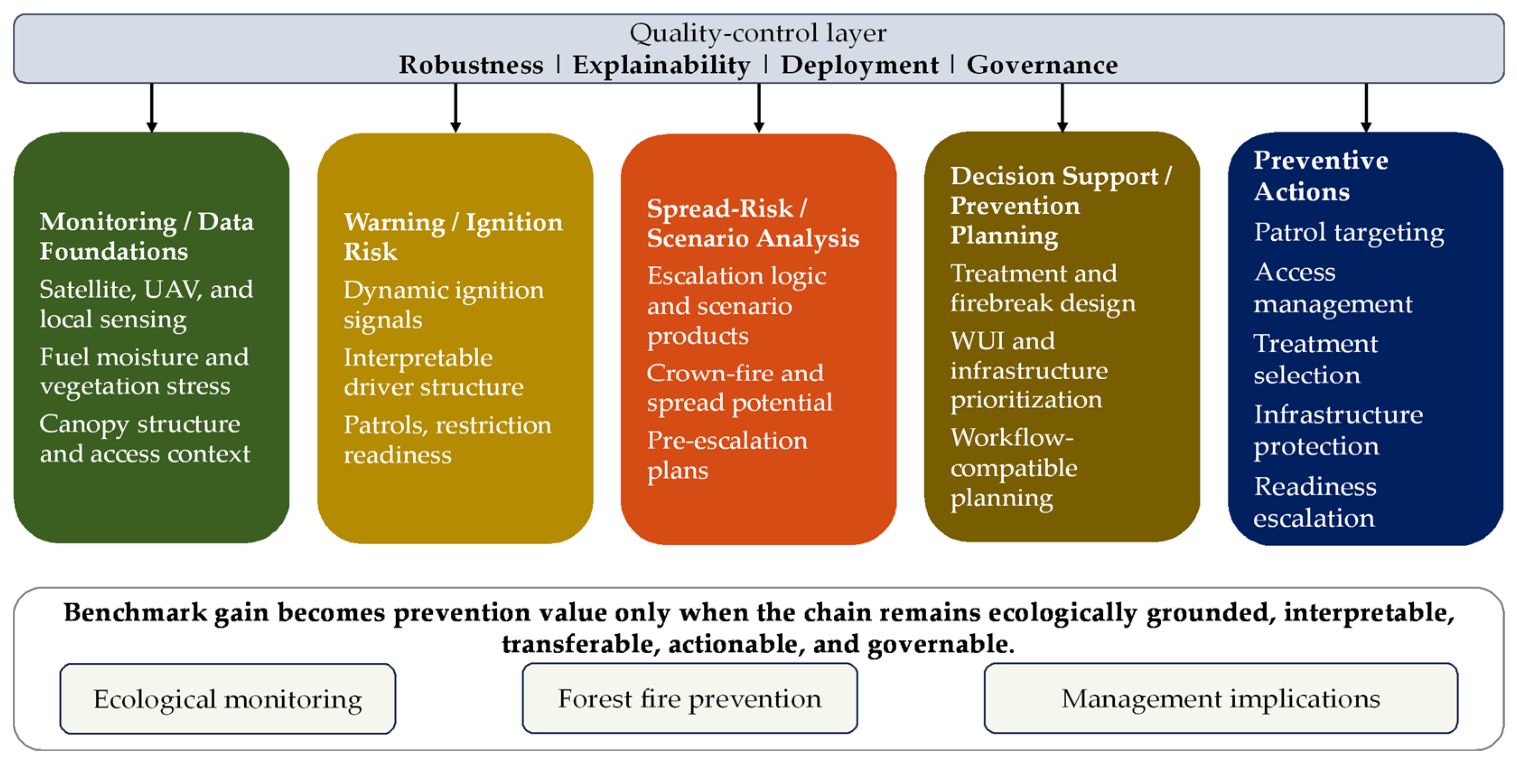
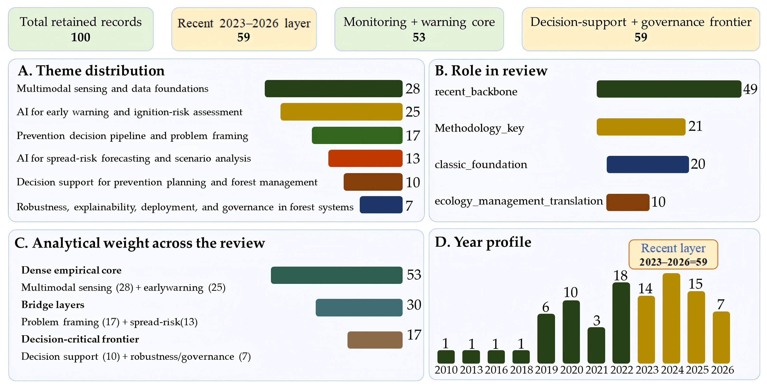
3. Multimodal Sensing and Data Foundations for Forest Fire Prevention
3.1. From Sensor Platforms to Prevention-Relevant Monitoring
3.2. Satellites, UAVs, and Local Sensors Are Complementary
3.3. Fuel Moisture, Vegetation Structure, and Other Latent State Variables
3.4. Datasets, Benchmarks, and Domain Shift
3.5. What Counts as a Strong Data Foundation

| Task Family | Typical Inputs and Scale | AI or Hybrid Methods | Evidence from Full-Text Synthesis | Prevention Decision Supported | Representative References |
|---|---|---|---|---|---|
| Fuel and ecological-condition monitoring | Fuel moisture, vegetation indices, canopy structure, LiDAR, satellite and UAV products | Random forest, CNNs, sequence models, physics-guided learning | Most convincing when remote estimates are checked against field, physical, or operational baselines. | Fuel-moisture alerts, treatment timing, seasonal readiness | [5,6,7,28,29,30,31,32,33,34,35,36,37,38,39,40,41,42,43,44,45,46,47,48,49,50,51,52,53,54,55,56,124,125] |
| Lightning, weather, and ignition-risk assessment | Lightning, FWI/NFDRS/KBDI, drought, topography, roads, settlements, historical ignitions | Logistic regression, random forest, boosting, XAI, spatial ML | Useful for patrol and warning when ignition causes and temporal validation are separated. | Patrol routing, access control, ignition-source mitigation | [28,29,30,31,32,57,58,59,60,61,62,63,64,65,66,67,68,69,70,71,72,73,74,75,76,77,78,79,80,81,82,83,84,85,86,128,129,130,131,132,133,134,135,136,137,138,139,140,141,142,143,144,145,146,147,148,149,150,151] |
| Smoke, flame, and active-fire detection with prevention relevance | UAV, camera, satellite thermal anomaly, IoT smoke and weather sensors | YOLO, CNNs, ensembles, federated or edge learning | Prevention value depends on lead time, false-alarm handling, latency, and verification workflow. | Early alert, field verification, local escalation avoidance | [15,16,17,18,19,20,21,22,23,24,28,29,30,31,32,33,34,35,36,37,38,39,40,41,42,43,44,45,46,47,48,49,50,51,52,103,104,105,106,107,108,109,110,111,112,113,114,115,116,117,118,119,120,121,122,123,152,153,154,155,156,157] |
| Spread-risk and scenario forecasting | Current perimeter, weather, fuels, topography, remote-sensing grids, simulation outputs | ConvLSTM, CNNs, surrogate models, hybrid simulation-ML, ensemble learning | Strongest when compared with deterministic spread models and when forecast horizon is explicit. | Pre-positioning, closure decisions, firebreak and fuel-treatment prioritization | [28,29,30,31,32,33,34,35,36,37,38,39,40,41,42,43,44,45,46,78,79,80,81,82,83,84,85,86,87,88,89,90,91,92,93,94,158,159,160,161,162,163,164,165,166,167,168,169] |
| Decision support and prevention planning | Risk layers, WUI exposure, powerline corridors, fuel treatments, severity potential, social constraints | Optimization, neural networks, XAI, multicriteria GIS, decision-support systems | Smaller evidence base, but clearest link to prevention when outputs map to management actions. | Fuel treatment, firebreaks, powerline inspection, WUI prioritization | [3,7,95,96,97,98,99,100,101,102,166,167,168,169,170,171,172,173,174] |
4. AI for Early Warning and Ignition-Risk Assessment
4.1. From Static Susceptibility to Prevention-Relevant Warning
4.2. Ecological Monitoring Variables and the Expanding Predictor Ecology
4.3. What Counts as Early Warning, and What Does Not
4.4. Explainability, Ignition Attribution, and Management Usefulness
4.5. Transferability, Benchmarks, and Limits of Operational Claims
4.6. Section Synthesis
5. AI for Spread-Risk Forecasting and Scenario Analysis
5.1. From Environmental Controls to Escalation Logic
5.2. Learning-Based Forecasting and the Rise in Benchmarkable Tasks
5.3. Simulation Coupling, Process Constraints, and Ecological Plausibility
5.4. Scenario Products, Forecast Horizons, and Prevention Relevance
5.5. Transferability, Operational Gaps, and Management Implications
5.6. Section Synthesis
6. Decision Support for Prevention Planning and Forest Management
| AI Product | Evidence Needed Before Operational Use | Preventive Action | Risk if Evidence Is Missing | Representative References |
|---|---|---|---|---|
| Ignition-risk map | Ignition-cause separation, temporal validation, lightning and human-pressure layers | Patrol planning, public-warning targeting, access restrictions | Static maps can be mistaken for daily prevention guidance. | [67,68,69,70,71,72,73,74,75,76,77,78,79,80,81,82,128,129,130,131,132,133,134,135,136,137,138,139,140,141,142,143,144,145,146,147,148,149,150,151] |
| Fuel-moisture or vegetation-stress estimate | Field/physical validation, update frequency, uncertainty range | Readiness level, treatment timing, seasonal staffing | Remote-sensing estimates may not transfer across canopy and ecosystem conditions. | [5,6,7,47,48,49,50,51,52,53,54,55,56,124,125] |
| Smoke or flame detector | False-alarm rate, latency, night/smoke/terrain tests, verification workflow | Early field verification and escalation control | High image accuracy may not produce useful warning under field constraints. | [20,21,22,23,24,28,29,30,31,32,33,34,35,36,37,38,39,40,41,42,43,44,45,46,47,48,49,50,51,52,103,104,105,106,107,108,109,110,111,112,113,114,115,116,117,118,119,120,121,122,123,152,153,154,155,156,157] |
| Spread forecast or scenario map | Comparison with fire-behavior model, horizon, wind/fuel sensitivity | Closure, pre-positioning, fuel-break prioritization | Retrospective fit can be mistaken for prospective decision support. | [28,29,30,31,32,33,34,35,36,37,38,39,40,41,42,43,44,45,46,83,84,85,86,87,88,89,90,91,92,93,94,158,159,160,161,162,163,164,165,166,167,168,169] |
| WUI or infrastructure exposure model | Asset data quality, feasibility, governance and equity constraints | Powerline inspection, defensible-space campaigns, community mitigation | Technically accurate risk layers may be institutionally unusable. | [14,68,69,70,71,72,95,96,97,98,99,100,101,102,170,171,172,173,174] |
6.1. Decision Support as the Integrative Layer
6.2. Fuel Treatments, Firebreaks, and Infrastructure-Oriented Prevention
6.3. Human Activity, WUI Exposure, and Spatial Prevention Planning
6.4. Decision-Support Systems and Workflow Compatibility
6.5. Why Decision Support Is Still Less Mature than It Appears
6.6. Section Synthesis
7. Robustness, Explainability, Deployment, and Governance
7.1. Robustness Is the Real Test of Prevention-Oriented AI
7.2. Explainability as Ecological and Management Interpretation
7.3. Deployment Readiness and the Gap Between Benchmarks and Operations
7.4. Governance, Accountability, and Appropriate Use
7.5. Requirements for a More Mature Field
7.6. Section Synthesis
8. Discussion and Future Directions for Prevention-Oriented AI in Forest Fire Prevention
9. Conclusions
- AI is most useful when it supports actionable prevention decisions before ignition or escalation, rather than focusing solely on detection accuracy or susceptibility mapping.
- Prevention value depends on selecting monitoring variables that are appropriate for specific management decisions and ecological conditions.
- Classical deterministic and probabilistic models remain necessary, and AI should be compared with, coupled to, or used to update fire-danger and spread baselines such as FWI, NFDRS, KBDI, Rothermel-type spread models, FARSITE, FlamMap, and ensemble simulation.
- Overall, the reviewed literature demonstrates substantial progress in AI-based prevention, while evidence for operational validation, cross-region transfer, and governance remains comparatively limited.
- Lightning activity should be included alongside human pressure where it is ecologically relevant, especially in boreal, montane, and remote forest systems.
- The most applicable near-term AI systems are hybrid, interpretable, and deployment-aware, combining remote sensing, meteorology, ignition-source data, fire-science baselines, uncertainty reporting, and clear management action after local validation against ecosystem conditions, sensor availability, agency workflows, and governance constraints.
Author Contributions
Funding
Data Availability Statement
Conflicts of Interest
References
- Jain, P.; Coogan, S.C.; Subramanian, S.G.; Crowley, M.; Taylor, S.; Flannigan, M.D. A review of machine learning applications in wildfire science and management. Environ. Rev. 2020, 28, 478–505. [Google Scholar] [CrossRef] [Scilit]
- Chen, Y.; Morton, D.C.; Randerson, J.T. Remote sensing for wildfire monitoring: Insights into burned area, emissions, and fire dynamics. One Earth 2024, 7, 1022–1028. [Google Scholar] [CrossRef] [Scilit]
- O’Mara, T.; Meador, A.S.; Colavito, M.; Waltz, A.; Barton, E. Navigating the evolving landscape of wildfire management: A systematic review of decision support tools. Trees. For. People 2024, 16, 100575. [Google Scholar] [CrossRef] [Scilit]
- Bhowmik, R.T.; Jung, Y.S.; Aguilera, J.A.; Prunicki, M.; Nadeau, K. A multi-modal wildfire prediction and early-warning system based on a novel machine learning framework. J. Environ. Manag. 2023, 341, 117908. [Google Scholar] [CrossRef] [Scilit] [PubMed]
- Schreck, J.S.; Petzke, W.; Jiménez, P.A.; Brummet, T.; Knievel, J.C.; James, E.; Kosović, B.; Gagne, D.J. Machine Learning and VIIRS Satellite Retrievals for Skillful Fuel Moisture Content Monitoring in Wildfire Management. Remote Sens. 2023, 15, 3372. [Google Scholar] [CrossRef] [Scilit]
- Miller, L.; Zhu, L.; Yebra, M.; Rüdiger, C.; Webb, G.I. Projecting live fuel moisture content via deep learning. Int. J. Wildland Fire 2023, 32, 709–727. [Google Scholar] [CrossRef] [Scilit]
- Magstadt, S.; Wei, Y. A neural network model to study factors impacting the selection of hazardous fuel treatment types in Colorado’s national forests. Int. J. Wildland Fire 2025, 34, WF24024. [Google Scholar] [CrossRef] [Scilit]
- Zaidi, A. Predicting wildfires in Algerian forests using machine learning models. Heliyon 2023, 9, e18064. [Google Scholar] [CrossRef] [Scilit] [PubMed]
- Banerjee, P. MODIS-FIRMS and ground-truthing-based wildfire likelihood mapping of Sikkim Himalaya using machine learning algorithms. Nat. Hazards 2022, 110, 899–935. [Google Scholar] [CrossRef] [Scilit]
- Vilar, L.; Gómez, I.; Vega, J.M.; Echavarría, P.; Riaño, D.; Martín, M.P. Multitemporal Modelling of Socio-Economic Wildfire Drivers in Central Spain between the 1980s and the 2000s: Comparing Generalized Linear Models to Machine Learning Algorithms. PLoS ONE 2016, 11, e0161344. [Google Scholar] [CrossRef] [Scilit] [PubMed]
- Sulova, A.; Arsanjani, J.J. Exploratory Analysis of Driving Force of Wildfires in Australia: An Application of Machine Learning within Google Earth Engine. Remote Sens. 2020, 13, 10. [Google Scholar] [CrossRef] [Scilit]
- Liang, H.; Zhang, M.; Wang, H. A Neural Network Model for Wildfire Scale Prediction Using Meteorological Factors. IEEE Access 2019, 7, 176746–176755. [Google Scholar] [CrossRef] [Scilit]
- Wang, L.; Zhao, Q.; Wen, Z.; Qu, J. RAFFIA: Short-term Forest Fire Danger Rating Prediction via Multiclass Logistic Regression. Sustainability 2018, 10, 4620. [Google Scholar] [CrossRef] [Scilit]
- Syphard, A.D.; Bar-Massada, A.; Butsic, V.; Keeley, J.E. Land Use Planning and Wildfire: Development Policies Influence Future Probability of Housing Loss. PLoS ONE 2013, 8, e71708. [Google Scholar] [CrossRef] [Scilit] [PubMed]
- Li, X.; Wang, S.; Yu, Z.; Liu, T.; Yan, H. Research and Implementation of Fire Warning Algorithm Based on Deep Learning. In Proceedings of the 2022 2nd International Symposium on Artificial Intelligence and Its Application on Media (ISAIAM), Xi’an, China, 10–12 June 2022; pp. 48–51. [Google Scholar] [CrossRef] [Scilit]
- Zitouni, L.; Cherni, I. The Impact of Artificial Intelligence in Predicting Forest Fires Using Spatio-Temporal Data Mining. In Proceedings of the 2024 IEEE International Conference on Advanced Systems and Emergent Technologies (IC_ASET), Hammamet, Tunisia, 27–29 April 2024; pp. 1–6. [Google Scholar] [CrossRef] [Scilit]
- Giannakidou, S.; Radoglou-Grammatikis, P.; Lagkas, T.; Argyriou, V.; Goudos, S.; Markakis, E.K.; Sarigiannidis, P. Leveraging the power of internet of things and artificial intelligence in forest fire prevention, detection, and restoration: A comprehensive survey. Internet Things 2024, 26, 101171. [Google Scholar] [CrossRef] [Scilit]
- Jodhani, K.H.; Patel, H.; Soni, U.; Patel, R.; Valodara, B.; Gupta, N.; Patel, A.; Omar, P.J. Assessment of forest fire severity and land surface temperature using Google Earth Engine: A case study of Gujarat State, India. Fire Ecol. 2024, 20, 23. [Google Scholar] [CrossRef] [Scilit]
- Alexandrov, D.; Pertseva, E.; Berman, I.; Pantiukhin, I.; Kapitonov, A. Analysis of Machine Learning Methods for Wildfire Security Monitoring with an Unmanned Aerial Vehicles. In Proceedings of the 2019 24th Conference of Open Innovations Association (FRUCT), Moscow, Russia, 8–12 April 2019; pp. 3–9. [Google Scholar] [CrossRef] [Scilit]
- He, L.; Zhou, Y.; Liu, L.; Zhang, Y.; Ma, J. Research and application of deep learning object detection methods for forest fire smoke recognition. Sci. Rep. 2025, 15, 16328. [Google Scholar] [CrossRef] [Scilit] [PubMed]
- Van, L.N.; Lee, G. Optimizing Stacked Ensemble Machine Learning Models for Accurate Wildfire Severity Mapping. Remote Sens. 2025, 17, 854. [Google Scholar] [CrossRef] [Scilit]
- Moghim, S.; Mehrabi, M. Wildfire assessment using machine learning algorithms in different regions. Fire Ecol. 2024, 20, 104. [Google Scholar] [CrossRef] [Scilit]
- Lever, J.; Arcucci, R. Sentimental wildfire: A social-physics machine learning model for wildfire nowcasting. J. Comput. Soc. Sci. 2022, 5, 1427–1465. [Google Scholar] [CrossRef] [Scilit]
- Yousefi, S.; Pourghasemi, H.R.; Emami, S.N.; Pouyan, S.; Eskandari, S.; Tiefenbacher, J.P. A machine learning framework for multi-hazards modeling and mapping in a mountainous area. Sci. Rep. 2020, 10, 12144. [Google Scholar] [CrossRef] [Scilit] [PubMed]
- Virts, K.S.; Wallace, J.M.; Hutchins, M.L.; Holzworth, R.H. Highlights of a new ground-based, hourly global lightning climatology. J. Geophys. Res. Atmos. 2013, 94, 1381–1391. [Google Scholar] [CrossRef] [Scilit]
- Hutchins, M.L.; Holzworth, R.H.; Virts, K.S.; Wallace, J.M.; Heckman, S. Radiated VLF energy differences of land and oceanic lightning inferred from the World Wide Lightning Location Network (WWLLN). J. Geophys. Res. Atmos. 2013, 40, 2390–2394. [Google Scholar] [CrossRef] [Scilit]
- Abarca, S.F.; Corbosiero, K.L.; Galarneau, T.J., Jr. An evaluation of the World Wide Lightning Location Network (WWLLN) using the National Lightning Detection Network (NLDN) as ground truth. J. Geophys. Res. Atmos. 2010, 115, D18206. [Google Scholar] [CrossRef] [Scilit]
- Rothermel, R.C. A Mathematical Model for Predicting Fire Spread in Wildland Fuels; Research Paper INT-115; USDA Forest Service: Ogden, UT, USA, 1972; 40p. [Google Scholar]
- Albini, F.A. Estimating Wildfire Behavior and Effects; General Technical Report INT-30; USDA Forest Service: Ogden, UT, USA, 1976. [Google Scholar]
- Van Wagner, C.E. Development and Structure of the Canadian Forest Fire Weather Index System; Forestry Technical Report 35; Canadian Forestry Service: Ottawa, ON, Canada, 1987. [Google Scholar]
- Deeming, J.E.; Burgan, R.E.; Cohen, J.D. The National Fire-Danger Rating System-1978; General Technical Report INT-39; USDA Forest Service: Ogden, UT, USA, 1977. [Google Scholar]
- Keetch, J.J.; Byram, G.M. A Drought Index for Forest Fire Control; Research Paper SE-38; USDA Forest Service: Asheville, NC, USA, 1968. [Google Scholar]
- Finney, M.A. FARSITE: Fire Area Simulator-Model Development and Evaluation; Research Paper RMRS-RP-4; USDA Forest Service: Ogden, UT, USA, 1998. [Google Scholar] [CrossRef] [Scilit]
- Scott, J.H.; Burgan, R.E. Standard Fire Behavior Fuel Models: A Comprehensive Set for Use with Rothermel’s Surface Fire Spread Model; General Technical Report RMRS-GTR-153; USDA Forest Service: Fort Collins, CO, USA, 2005. [Google Scholar]
- Andrews, P.L. BehavePlus Fire Modeling System, Version 5.0: Variables; General Technical Report RMRS-GTR-213; USDA Forest Service: Fort Collins, CO, USA, 2009. [Google Scholar]
- Sullivan, A.L. Wildland surface fire spread modelling, 1990–2007. 1: Physical and quasi-physical models. Int. J. Wildland Fire 2009, 18, 349–368. [Google Scholar] [CrossRef] [Scilit]
- Sullivan, A.L. Wildland surface fire spread modelling, 1990–2007. 2: Empirical and quasi-empirical models. Int. J. Wildland Fire 2009, 18, 369–386. [Google Scholar] [CrossRef] [Scilit]
- Sullivan, A.L. Wildland surface fire spread modelling, 1990–2007. 3: Simulation and mathematical analogue models. Int. J. Wildland Fire 2009, 18, 387–403. [Google Scholar] [CrossRef] [Scilit]
- Finney, M.A. An overview of FlamMap fire modeling capabilities. In Fuels Management-How to Measure Success: Conference Proceedings; Andrews, P.L., Butler, B.W., Eds.; Proceedings RMRS-P-41; USDA Forest Service: Fort Collins, CO, USA, 2006; pp. 213–220. [Google Scholar]
- Finney, M.A.; Grenfell, I.C.; McHugh, C.W.; Seli, R.C.; Trethewey, D.; Stratton, R.D.; Brittain, S. A method for ensemble wildland fire simulation. Environ. Model. Assess. 2011, 16, 153–167. [Google Scholar] [CrossRef] [Scilit]
- Cruz, M.G.; Alexander, M.E. Assessing crown fire potential in coniferous forests of western North America: A critique of current approaches and recent simulation studies. Int. J. Wildland Fire 2010, 19, 377–398. [Google Scholar] [CrossRef] [Scilit]
- Rothermel, R.C. Predicting Behavior and Size of Crown Fires in the Northern Rocky Mountains; Research Paper INT-438; USDA Forest Service: Ogden, UT, USA, 1991. [Google Scholar]
- Van Wagner, C.E. Conditions for the start and spread of crown fire. Can. J. For. Res. 1977, 7, 23–34. [Google Scholar] [CrossRef] [Scilit]
- Alexander, M.E.; Cruz, M.G. Crown fire dynamics in conifer forests. In Synthesis of Knowledge of Extreme Fire Behavior: Volume I for Fire Managers; USDA Forest Service: Washington, DC, USA, 2011. [Google Scholar]
- Anderson, H.E. Aids to Determining Fuel Models for Estimating Fire Behavior; General Technical Report INT-122; USDA Forest Service: Ogden, UT, USA, 1982. [Google Scholar]
- Stocks, B.J.; Lawson, B.D.; Alexander, M.E.; Van Wagner, C.E.; McAlpine, R.S.; Lynham, T.J.; Dube, D.E. The Canadian Forest Fire Danger Rating System: An overview. For. Chron. 1989, 65, 450–457. [Google Scholar] [CrossRef] [Scilit]
- Chuvieco, E.; Congalton, R.G. Application of remote sensing and geographic information systems to forest fire hazard mapping. Remote Sens. Environ. 1989, 29, 147–159. [Google Scholar] [CrossRef] [Scilit]
- Chuvieco, E.; Riaño, D.; Aguado, I.; Cocero, D. Estimation of fuel moisture content from multitemporal analysis of Landsat Thematic Mapper reflectance data: Applications in fire danger assessment. Int. J. Remote Sens. 2002, 23, 2145–2162. [Google Scholar] [CrossRef] [Scilit]
- Yebra, M.; Dennison, P.E.; Chuvieco, E.; Riaño, D.; Zylstra, P.; Hunt, E.R.; Danson, F.M.; Qi, Y.; Jurdao, S. A global review of remote sensing of live fuel moisture content for fire danger assessment: Moving towards operational products. Remote Sens. Environ. 2013, 136, 455–468. [Google Scholar] [CrossRef] [Scilit]
- Dennison, P.E.; Roberts, D.A.; Thorgusen, S.R.; Regelbrugge, J.C.; Weise, D.; Lee, C. Modeling seasonal changes in live fuel moisture and equivalent water thickness using a cumulative water balance index. Remote Sens. Environ. 2003, 88, 442–452. [Google Scholar] [CrossRef] [Scilit]
- Giglio, L.; Schroeder, W.; Justice, C.O. The collection 6 MODIS active fire detection algorithm and fire products. Remote Sens. Environ. 2016, 178, 31–41. [Google Scholar] [CrossRef] [Scilit] [PubMed]
- Schroeder, W.; Oliva, P.; Giglio, L.; Csiszar, I.A. The New VIIRS 375 m active fire detection data product: Algorithm description and initial assessment. Remote Sens. Environ. 2014, 143, 85–96. [Google Scholar] [CrossRef] [Scilit]
- Roy, D.P.; Boschetti, L.; Justice, C.O.; Ju, J. The collection 5 MODIS burned area product: Global evaluation by comparison with the MODIS active fire product. Remote Sens. Environ. 2008, 112, 3690–3707. [Google Scholar] [CrossRef] [Scilit]
- Justice, C.O.; Giglio, L.; Korontzi, S.; Owens, J.; Morisette, J.T.; Roy, D.; Descloitres, J.; Alleaume, S.; Petitcolin, F.; Kaufman, Y. The MODIS fire products. Remote Sens. Environ. 2002, 83, 244–262. [Google Scholar] [CrossRef] [Scilit]
- Wooster, M.J.; Roberts, G.; Perry, G.L.W.; Kaufman, Y.J. Retrieval of biomass combustion rates and totals from fire radiative power observations: FRP derivation and calibration relationships between biomass consumption and fire radiative energy release. J. Geophys. Res. Atmos. 2005, 110, D24311. [Google Scholar] [CrossRef] [Scilit]
- Chuvieco, E.; Aguado, I.; Yebra, M.; Nieto, H.; Salas, J.; Martín, M.P.; Vilar, L.; Martínez, J.; Martín, S.; Ibarra, P.; et al. Development of a framework for fire risk assessment using remote sensing and geographic information system technologies. Ecol. Model. 2010, 221, 46–58. [Google Scholar] [CrossRef] [Scilit]
- Abatzoglou, J.T.; Williams, A.P. Impact of anthropogenic climate change on wildfire across western US forests. Proc. Natl. Acad. Sci. USA 2016, 113, 11770–11775. [Google Scholar] [CrossRef] [Scilit] [PubMed]
- Jolly, W.M.; Cochrane, M.A.; Freeborn, P.H.; Holden, Z.A.; Brown, T.J.; Williamson, G.J.; Bowman, D.M.J.S. Climate-induced variations in global wildfire danger from 1979 to 2013. Nat. Commun. 2015, 6, 7537. [Google Scholar] [CrossRef] [Scilit] [PubMed]
- Bowman, D.M.J.S.; Balch, J.K.; Artaxo, P.; Bond, W.J.; Carlson, J.M.; Cochrane, M.A.; D’Antonio, C.M.; DeFries, R.S.; Doyle, J.C.; Harrison, S.P.; et al. Fire in the Earth system. Science 2009, 324, 481–484. [Google Scholar] [CrossRef] [Scilit] [PubMed]
- Moritz, M.A.; Parisien, M.-A.; Batllori, E.; Krawchuk, M.A.; Van Dorn, J.; Ganz, D.J.; Hayhoe, K. Climate change and disruptions to global fire activity. Ecosphere 2012, 3, art49. [Google Scholar] [CrossRef] [Scilit]
- Flannigan, M.; Stocks, B.; Turetsky, M.; Wotton, M. Impacts of climate change on fire activity and fire management in the circumboreal forest. Glob. Change Biol. 2009, 15, 549–560. [Google Scholar] [CrossRef] [Scilit]
- Krawchuk, M.A.; Moritz, M.A.; Parisien, M.-A.; Van Dorn, J.; Hayhoe, K. Global pyrogeography: The current and future distribution of wildfire. PLoS ONE 2009, 4, e5102. [Google Scholar] [CrossRef] [Scilit] [PubMed]
- Pausas, J.G.; Keeley, J.E. A burning story: The role of fire in the history of life. BioScience 2009, 59, 593–601. [Google Scholar] [CrossRef] [Scilit]
- Keeley, J.E. Fire intensity, fire severity and burn severity: A brief review and suggested usage. Int. J. Wildland Fire 2009, 18, 116–126. [Google Scholar] [CrossRef] [Scilit]
- Archibald, S.; Lehmann, C.E.R.; Gómez-Dans, J.L.; Bradstock, R.A. Defining pyromes and global syndromes of fire regimes. Proc. Natl. Acad. Sci. USA 2013, 110, 6442–6447. [Google Scholar] [CrossRef] [Scilit] [PubMed]
- Andela, N.; Morton, D.C.; Giglio, L.; Chen, Y.; van der Werf, G.R.; Kasibhatla, P.S.; DeFries, R.S.; Collatz, G.J.; Hantson, S.; Kloster, S.; et al. A human-driven decline in global burned area. Science 2017, 356, 1356–1362. [Google Scholar] [CrossRef] [Scilit] [PubMed]
- Balch, J.K.; Bradley, B.A.; Abatzoglou, J.T.; Nagy, R.C.; Fusco, E.J.; Mahood, A.L. Human-started wildfires expand the fire niche across the United States. Proc. Natl. Acad. Sci. USA 2017, 114, 2946–2951. [Google Scholar] [CrossRef] [Scilit] [PubMed]
- Radeloff, V.C.; Helmers, D.P.; Kramer, H.A.; Mockrin, M.H.; Alexandre, P.M.; Bar-Massada, A.; Butsic, V.; Hawbaker, T.J.; Martinuzzi, S.; Syphard, A.D.; et al. Rapid growth of the US wildland-urban interface raises wildfire risk. Proc. Natl. Acad. Sci. USA 2018, 115, 3314–3319. [Google Scholar] [CrossRef] [Scilit] [PubMed]
- Cohen, J.D. Preventing disaster: Home ignitability in the wildland-urban interface. J. For. 2000, 98, 15–21. [Google Scholar] [CrossRef] [Scilit]
- Syphard, A.D.; Radeloff, V.C.; Keeley, J.E.; Hawbaker, T.J.; Clayton, M.K.; Stewart, S.I.; Hammer, R.B. Human influence on California fire regimes. Ecol. Appl. 2007, 17, 1388–1402. [Google Scholar] [CrossRef] [Scilit] [PubMed]
- Hammer, R.B.; Stewart, S.I.; Radeloff, V.C. Demographic trends, the wildland-urban interface, and wildfire management. Soc. Nat. Resour. 2009, 22, 777–782. [Google Scholar] [CrossRef] [Scilit]
- Theobald, D.M.; Romme, W.H. Expansion of the US wildland-urban interface. Landsc. Urban Plan. 2007, 83, 340–354. [Google Scholar] [CrossRef] [Scilit]
- Veraverbeke, S.; Rogers, B.M.; Goulden, M.L.; Jandt, R.R.; Miller, C.E.; Wiggins, E.B.; Randerson, J.T. Lightning as a major driver of recent large fire years in North American boreal forests. Nat. Clim. Change 2017, 7, 529–534. [Google Scholar] [CrossRef] [Scilit]
- Wierzchowski, J.; Heathcott, M.; Flannigan, M.D. Lightning and lightning fire, central cordillera, Canada. Int. J. Wildland Fire 2002, 11, 41–51. [Google Scholar] [CrossRef] [Scilit]
- Wotton, B.M.; Martell, D.L.; Logan, K.A. Climate change and people-caused forest fire occurrence in Ontario. Clim. Change 2003, 60, 275–295. [Google Scholar] [CrossRef] [Scilit]
- Podur, J.; Martell, D.L.; Knight, K. Statistical quality control analysis of forest fire activity in Canada. Can. J. For. Res. 2002, 32, 195–205. [Google Scholar] [CrossRef] [Scilit]
- Preisler, H.K.; Westerling, A.L.; Gebert, K.M.; Munoz-Arriola, F.; Holmes, T.P. Spatially explicit forecasts of large wildland fire probability and suppression costs for California. Int. J. Wildland Fire 2011, 20, 508–517. [Google Scholar] [CrossRef] [Scilit]
- Preisler, H.K.; Brillinger, D.R.; Burgan, R.E.; Benoit, J.W. Probability based models for estimation of wildfire risk. Int. J. Wildland Fire 2004, 13, 133–142. [Google Scholar] [CrossRef] [Scilit]
- Parisien, M.-A.; Moritz, M.A. Environmental controls on the distribution of wildfire at multiple spatial scales. Ecol. Monogr. 2009, 79, 127–154. [Google Scholar] [CrossRef] [Scilit]
- Rodrigues, M.; de la Riva, J. An insight into machine-learning algorithms to model human-caused wildfire occurrence. Environ. Model. Softw. 2014, 57, 192–201. [Google Scholar] [CrossRef] [Scilit]
- Bar-Massada, A.; Syphard, A.D.; Stewart, S.I.; Radeloff, V.C. Wildfire ignition-distribution modelling: A comparative study in the Huron-Manistee National Forest, Michigan, USA. Int. J. Wildland Fire 2013, 22, 174–183. [Google Scholar]
- Oliveira, S.; Oehler, F.; San-Miguel-Ayanz, J.; Camia, A.; Pereira, J.M.C. Modeling spatial patterns of fire occurrence in Mediterranean Europe using multiple regression and random forest. For. Ecol. Manag. 2012, 275, 117–129. [Google Scholar] [CrossRef] [Scilit]
- Bedia, J.; Herrera, S.; Gutiérrez, J.M.; Benali, A.; Brands, S.; Mota, B.; Moreno, J.M. Global patterns in the sensitivity of burned area to fire-weather: Implications for climate change. Agric. For. Meteorol. 2015, 214–215, 369–379. [Google Scholar] [CrossRef] [Scilit]
- Barbero, R.; Abatzoglou, J.T.; Larkin, N.K.; Kolden, C.A.; Stocks, B. Climate change presents increased potential for very large fires in the contiguous United States. Int. J. Wildland Fire 2015, 24, 892–899. [Google Scholar] [CrossRef] [Scilit]
- Westerling, A.L. Increasing western US forest wildfire activity: Sensitivity to changes in the timing of spring. Philos. Trans. R. Soc. B 2016, 371, 20150178. [Google Scholar] [CrossRef] [Scilit] [PubMed]
- Westerling, A.L.; Hidalgo, H.G.; Cayan, D.R.; Swetnam, T.W. Warming and earlier spring increase western U.S. forest wildfire activity. Science 2006, 313, 940–943. [Google Scholar] [CrossRef] [Scilit] [PubMed]
- Parks, S.A.; Abatzoglou, J.T. Warmer and drier fire seasons contribute to increases in area burned at high severity in western US forests from 1985 to 2017. Geophys. Res. Lett. 2020, 47, e2020GL089858. [Google Scholar] [CrossRef] [Scilit]
- Holden, Z.A.; Swanson, A.; Luce, C.H.; Jolly, W.M.; Maneta, M.; Oyler, J.W.; Warren, D.A.; Parsons, R.; Affleck, D. Decreasing fire season precipitation increased recent western US forest wildfire activity. Proc. Natl. Acad. Sci. USA 2018, 115, E8349–E8357. [Google Scholar] [CrossRef] [Scilit] [PubMed]
- Littell, J.S.; McKenzie, D.; Peterson, D.L.; Westerling, A.L. Climate and wildfire area burned in western U.S. ecoprovinces, 1916–2003. Ecol. Appl. 2009, 19, 1003–1021. [Google Scholar] [CrossRef] [Scilit] [PubMed]
- Short, K.C. A spatial database of wildfires in the United States, 1992–2011. Earth Syst. Sci. Data 2014, 6, 1–27. [Google Scholar] [CrossRef] [Scilit]
- Short, K.C. Spatial Wildfire Occurrence Data for the United States, 1992–2020 [FPA_FOD_20221014], 6th ed.; Forest Service Research Data Archive: Fort Collins, CO, USA, 2022. [Google Scholar] [CrossRef] [Scilit]
- Forkel, M.; Andela, N.; Harrison, S.P.; Lasslop, G.; van Marle, M.; Chuvieco, E.; Dorigo, W.; Forrest, M.; Hantson, S.; Heil, A.; et al. Emergent relationships with respect to burned area in global satellite observations and fire-enabled vegetation models. Biogeosciences 2019, 16, 57–76. [Google Scholar] [CrossRef] [Scilit]
- Hantson, S.; Arneth, A.; Harrison, S.P.; Kelley, D.I.; Prentice, I.C.; Rabin, S.S.; Archibald, S.; Mouillot, F.; Arnold, S.R.; Artaxo, P.; et al. The status and challenge of global fire modelling. Biogeosciences 2016, 13, 3359–3375. [Google Scholar] [CrossRef] [Scilit]
- Rabin, S.S.; Melton, J.R.; Lasslop, G.; Bachelet, D.; Forrest, M.; Hantson, S.; Kaplan, J.O.; Li, F.; Mangeon, S.; Ward, D.S.; et al. The Fire Modeling Intercomparison Project (FireMIP), phase 1: Experimental and analytical protocols with detailed model descriptions. Geosci. Model Dev. 2017, 10, 1175–1197. [Google Scholar] [CrossRef] [Scilit]
- Hakes, R.S.P.; Caton, S.E.; Gorham, D.J.; Gollner, M.J. A review of pathways for building fire spread in the wildland urban interface part II: Response of components and systems and mitigation strategies in the United States. Fire Technol. 2017, 53, 429–473. [Google Scholar] [CrossRef]
- Ager, A.A.; Vaillant, N.M.; Finney, M.A. A comparison of landscape fuel treatment strategies to mitigate wildland fire risk in the urban interface and preserve old forest structure. For. Ecol. Manag. 2010, 259, 1556–1570. [Google Scholar] [CrossRef] [Scilit]
- Ager, A.A.; Finney, M.A.; Kerns, B.K.; Maffei, H. Modeling wildfire risk to northern spotted owl habitat in Central Oregon, USA. For. Ecol. Manag. 2007, 246, 45–56. [Google Scholar] [CrossRef] [Scilit]
- Alcasena, F.J.; Ager, A.A.; Salis, M.; Day, M.A.; Vega-García, C. Optimizing prescribed fire allocation for managing fire risk in central Catalonia. Sci. Total Environ. 2018, 621, 872–885. [Google Scholar] [CrossRef] [Scilit] [PubMed]
- Thompson, M.P.; Calkin, D.E. Uncertainty and risk in wildland fire management: A review. J. Environ. Manag. 2011, 92, 1895–1909. [Google Scholar] [CrossRef] [Scilit] [PubMed]
- Calkin, D.E.; Cohen, J.D.; Finney, M.A.; Thompson, M.P. How risk management can prevent future wildfire disasters in the wildland-urban interface. Proc. Natl. Acad. Sci. USA 2014, 111, 746–751. [Google Scholar] [CrossRef] [Scilit] [PubMed]
- McCaffrey, S.; Toman, E.; Stidham, M.; Shindler, B. Social science research related to wildfire management: An overview of recent findings and future research needs. Int. J. Wildland Fire 2013, 22, 15–24. [Google Scholar] [CrossRef] [Scilit]
- Costa, J.; Martinho, D. Artificial Intelligence for Geospatial Decision Support in Rural Wildfire Management: A Configurational Mapping Review. Fire 2026, 9, 131. [Google Scholar] [CrossRef] [Scilit]
- Singh, H.; Ang, L.-M.; Srivastava, S. Active wildfire detection via satellite imagery and machine learning: An empirical investigation of Australian wildfires. Nat. Hazards 2025, 121, 9777–9800. [Google Scholar] [CrossRef] [Scilit]
- Akhloufi, M.A.; Couturier, A.; Castro, N.A. Unmanned Aerial Vehicles for Wildland Fires: Sensing, Perception, Cooperation and Assistance. Drones 2021, 5, 15. [Google Scholar] [CrossRef] [Scilit]
- Shamta, I.; Demir, B.E. Development of a deep learning-based surveillance system for forest fire detection and monitoring using UAV. PLoS ONE 2024, 19, e0299058. [Google Scholar] [CrossRef] [Scilit] [PubMed]
- Ramadan, M.N.; Basmaji, T.; Gad, A.; Hamdan, H.; Akgün, B.T.; Ali, M.A.; Alkhedher, M.; Ghazal, M. Towards early forest fire detection and prevention using AI-powered drones and the IoT. Internet Things 2024, 27, 101248. [Google Scholar] [CrossRef] [Scilit]
- Zheng, Z.; Huang, R.; Shang, Y.; Jin, W. Wildfire smoke detection based on enhanced YOLOv7 with video images. Measurement 2026, 272, 121045. [Google Scholar] [CrossRef] [Scilit]
- Sathishkumar, V.E.; Cho, J.; Subramanian, M.; Naren, O.S. Forest fire and smoke detection using deep learning-based learning without forgetting. Fire Ecol. 2023, 19, 9. [Google Scholar] [CrossRef] [Scilit]
- Karaş, İ.R.; Sevinç, H.K.; Ibrahim, H.; Mohamed, M.; Şahin, S.; Oumate, M.O. Deep Learning-Driven Wildfire Detection in Türkiye Using Sentinel-2 Imagery and Convolutional Neural Networks. Int. Arch. Photogramm. Remote Sens. Spat. Inf. Sci. 2026, 48, 179–185. [Google Scholar] [CrossRef] [Scilit]
- Kinaneva, D.; Hristov, G.; Georgiev, G.; Kyuchukov, P.; Zahariev, P. An artificial intelligence approach to real-time automatic smoke detection by unmanned aerial vehicles and forest observation systems. In Proceedings of the 2020 International Conference on Biomedical Innovations and Applications (BIA), Varna, Bulgaria, 24–27 September 2020; pp. 133–138. [Google Scholar] [CrossRef] [Scilit]
- Ramos, L.T.; Casas, E.; Romero, C.; Rivas-Echeverría, F.; Bendek, E. A study of YOLO architectures for wildfire and smoke detection in ground and aerial imagery. Results Eng. 2025, 26, 104869. [Google Scholar] [CrossRef] [Scilit]
- Zhu, W.; Niu, S.; Yue, J.; Zhou, Y. Multiscale wildfire and smoke detection in complex drone forest environments based on YOLOv8. Sci. Rep. 2025, 15, 2399. [Google Scholar] [CrossRef] [Scilit] [PubMed]
- Wang, L.; Zhang, H.; Zhang, Y.; Hu, K.; An, K. A Deep Learning-Based Experiment on Forest Wildfire Detection in Machine Vision Course. IEEE Access 2023, 11, 32671–32681. [Google Scholar] [CrossRef] [Scilit]
- Bahhar, C.; Ksibi, A.; Ayadi, M.; Jamjoom, M.; Ullah, Z.; Soufiene, B.O.; Sakli, H. Wildfire and Smoke Detection Using Staged YOLO Model and Ensemble CNN. Electronics 2023, 12, 228. [Google Scholar] [CrossRef] [Scilit]
- Thangavel, K.; Spiller, D.; Sabatini, R.; Amici, S.; Sasidharan, S.T.; Fayek, H.M.; Marzocca, P. Autonomous Satellite Wildfire Detection Using Hyperspectral Imagery and Neural Networks: A Case Study on Australian Wildfire. Remote Sens. 2023, 15, 720. [Google Scholar] [CrossRef] [Scilit]
- Pettorru, G.; Fadda, M.; Girau, R.; Sole, M.; Anedda, M.; Giusto, D. Using Artificial Intelligence and IoT Solution for Forest Fire Prevention. In Proceedings of the 2023 International Conference on Computing, Networking and Communications (ICNC), Honolulu, HI, USA, 20–22 February 2023; pp. 414–418. [Google Scholar] [CrossRef] [Scilit]
- Sayad, Y.O.; Mousannif, H.; Al Moatassime, H. Predictive modeling of wildfires: A new dataset and machine learning approach. Fire Saf. J. 2019, 104, 130–146. [Google Scholar] [CrossRef] [Scilit]
- Ali, A.; Islam, U. Federated Learning for Smart and Sustainable Forest Fire Detection in Green Internet of Things. Estidamaa 2025, 2025, 13–20. [Google Scholar] [CrossRef] [Scilit] [PubMed]
- Nethravathi, J.; Keerthana, M.L.; Gagan, L.R.; Thejaswi, S. An Intelligent Forest Fire Detection System Using Machine Learning. Int. J. Sci. Res. Eng. Manag. 2026, 10, 1–9. [Google Scholar] [CrossRef] [Scilit]
- Sinato, F.; Rivas, C. Territorially-Specialized Machine Learning Models for Wildfire Risk Prediction Across Argentina Using Satellite Data and H3 Hexagonal Grids. Preprint. Calif. Digit. Libr. (CDL) 2026. [Google Scholar] [CrossRef] [Scilit]
- Benzekri, W.; Moussati, A.E.; Moussaoui, O.; Berrajaa, M. Early Forest Fire Detection System using Wireless Sensor Network and Deep Learning. Int. J. Adv. Comput. Sci. Appl. 2020, 11, 496–503. [Google Scholar] [CrossRef] [Scilit]
- Balachandran, G.; Govindasamy, S.; Sankar, R.; Vidhyasree, V.; Sunheriya, N.; Attar, H. An Internet of Things (IoT) Assisted Forest Fire Detection Mechanism Using Hybrid Classification and Learning Model. In Proceedings of the 2024 International Conference on Innovative Computing Intelligent Communication and Smart Electrical Systems (ICSES), Chennai, India, 12–13 December 2024; pp. 1–6. [Google Scholar] [CrossRef] [Scilit]
- Yan, X.; Chen, R. Application Strategy of Unmanned Aerial Vehicle Swarms in Forest Fire Detection Based on the Fusion of Particle Swarm Optimization and Artificial Bee Colony Algorithm. Appl. Sci. 2024, 14, 4937. [Google Scholar] [CrossRef] [Scilit]
- Kutchartt, E.; González-Olabarria, J.R.; Aquilué, N.; Trasobares, A.; Pirotti, F. Estimating canopy fuels across Europe with satellite data and allometric equations. Int. Arch. Photogramm. Remote Sens. Spat. Inf. Sci. 2024, 48, 279–285. [Google Scholar] [CrossRef] [Scilit]
- Fan, C.; Zhang, Y.; Chen, R.; Zhang, H.; Yin, J.; Li, Y.; He, B.; Quan, X. Physics-guided deep learning for geostationary satellite-based estimation of dead fuel moisture content in Southwest China. Remote Sens. Environ. 2026, 335, 115259. [Google Scholar] [CrossRef] [Scilit]
- Khan, A.; Hassan, B.; Khan, S.; Ahmed, R.; Abuassba, A. DeepFire: A Novel Dataset and Deep Transfer Learning Benchmark for Forest Fire Detection. Mob. Inf. Syst. 2022, 2022, 5358359. [Google Scholar] [CrossRef] [Scilit]
- Saydirasulovich, S.N.; Mukhiddinov, M.; Djuraev, O.; Abdusalomov, A.; Cho, Y.I. An Improved Wildfire Smoke Detection Based on YOLOv8 and UAV Images. Sensors 2023, 23, 8374. [Google Scholar] [CrossRef] [Scilit] [PubMed]
- Zhang, G.; Wang, M.; Liu, K. Forest Fire Susceptibility Modeling Using a Convolutional Neural Network for Yunnan Province of China. Int. J. Disaster Risk Sci. 2019, 10, 386–403. [Google Scholar] [CrossRef] [Scilit]
- Tonini, M.; D’Andrea, M.; Biondi, G.; Esposti, S.D.; Trucchia, A.; Fiorucci, P. A Machine Learning-Based Approach for Wildfire Susceptibility Mapping: The case study of the Liguria region in Italy. Geosciences 2020, 10, 105. [Google Scholar] [CrossRef] [Scilit]
- Gholamnia, K.; Nachappa, T.G.; Ghorbanzadeh, O.; Blaschke, T. Comparisons of Diverse Machine Learning Approaches for Wildfire Susceptibility Mapping. Symmetry 2020, 12, 604. [Google Scholar] [CrossRef] [Scilit]
- Bountzouklis, C.; Fox, D.; Di Bernardino, E. Predicting wildfire ignition causes in Southern France using eXplainable Artificial Intelligence (XAI) methods. Environ. Res. Lett. 2023, 18, 044038. [Google Scholar] [CrossRef] [Scilit]
- Tong, Q.; Gernay, T. Mapping wildfire ignition probability and predictor sensitivity with ensemble-based machine learning. Nat. Hazards 2023, 119, 1551–1582. [Google Scholar] [CrossRef] [Scilit]
- Qiu, L.; Chen, J.; Fan, L.; Sun, L.; Zheng, C. High-resolution mapping of wildfire drivers in California based on machine learning. Sci. Total Environ. 2022, 833, 155155. [Google Scholar] [CrossRef] [Scilit] [PubMed]
- Zhao, L.; Ge, Y.; Guo, S.; Li, H.; Li, X.; Sun, L.; Chen, J. Forest fire susceptibility mapping based on precipitation-constrained cumulative dryness status information in Southeast China: A novel machine learning modeling approach. For. Ecol. Manag. 2024, 558, 121771. [Google Scholar] [CrossRef] [Scilit]
- Khodaee, M.; Easterday, K.; Klausmeyer, K. Integrating hydrological parameters in wildfire risk assessment: A machine learning approach for mapping wildfire probability. Environ. Res. Lett. 2024, 19, 114043. [Google Scholar] [CrossRef] [Scilit]
- Abujayyab, S.K.M.; Kassem, M.M.; Khan, A.A.; Wazirali, R.; Coşkun, M.; Taşoğlu, E.; Öztürk, A.; Toprak, F. Wildfire Susceptibility Mapping Using Five Boosting Machine Learning Algorithms: The Case Study of the Mediterranean Region of Turkey. Adv. Civ. Eng. 2022, 2022, 3959150. [Google Scholar] [CrossRef] [Scilit]
- Iban, M.C.; Sekertekin, A. Machine learning based wildfire susceptibility mapping using remotely sensed fire data and GIS: A case study of Adana and Mersin provinces, Turkey. Ecol. Inform. 2022, 69, 101647. [Google Scholar] [CrossRef] [Scilit]
- Nur, A.S.; Kim, Y.J.; Lee, J.; Lee, C.-W. Spatial Prediction of Wildfire Susceptibility Using Hybrid Machine Learning Models Based on Support Vector Regression in Sydney, Australia. Remote Sens. 2023, 15, 760. [Google Scholar] [CrossRef] [Scilit]
- Xie, L.; Zhang, R.; Zhan, J.; Li, S.; Shama, A.; Zhan, R.; Wang, T.; Lv, J.; Bao, X.; Wu, R. Wildfire Risk Assessment in Liangshan Prefecture, China Based on An Integration Machine Learning Algorithm. Remote Sens. 2022, 14, 4592. [Google Scholar] [CrossRef] [Scilit]
- Porras, F.P.; Triviño-Tarradas, P.; Cima-Rodríguez, C.; Larriva, J.E.M.D.; García-Ferrer, A.; Mesas-Carrascosa, F.J. Machine Learning Methods and Synthetic Data Generation to Predict Large Wildfires. Sensors 2021, 21, 3694. [Google Scholar] [CrossRef] [Scilit] [PubMed]
- Shmuel, A.; Heifetz, E. Global Wildfire Susceptibility Mapping Based on Machine Learning Models. Forests 2022, 13, 1050. [Google Scholar] [CrossRef] [Scilit]
- Jaafari, A.; Mafi-Gholami, D.; Pham, B.T.; Bui, D.T. Wildfire Probability Mapping: Bivariate vs. Multivariate Statistics. Remote Sens. 2019, 11, 618. [Google Scholar] [CrossRef] [Scilit]
- Milanović, S.; Marković, N.; Pamučar, D.; Gigović, L.; Kostić, P.; Milanović, S.D. Forest Fire Probability Mapping in Eastern Serbia: Logistic Regression versus Random Forest Method. Forests 2020, 12, 5. [Google Scholar] [CrossRef] [Scilit]
- Shao, Y.; Feng, Z.; Cao, M.; Wang, W.; Sun, L.; Yang, X.; Ma, T.; Guo, Z.; Fahad, S.; Liu, X.; et al. An Ensemble Model for Forest Fire Occurrence Mapping in China. Forests 2023, 14, 704. [Google Scholar] [CrossRef] [Scilit]
- Pang, Y.; Li, Y.; Feng, Z.; Feng, Z.; Zhao, Z.; Chen, S.; Zhang, H. Forest Fire Occurrence Prediction in China Based on Machine Learning Methods. Remote Sens. 2022, 14, 5546. [Google Scholar] [CrossRef] [Scilit]
- Ismail, F.N.; Woodford, B.J.; Licorish, S.A.; Miller, A.D. An assessment of existing wildfire danger indices in comparison to one-class machine learning models. Nat. Hazards 2024, 120, 14837–14868. [Google Scholar] [CrossRef] [Scilit]
- Tran, T.T.K.; Janizadeh, S.; Bateni, S.M.; Jun, C.; Kim, D.; Trauernicht, C.; Rezaie, F.; Giambelluca, T.W.; Panahi, M. Improving the prediction of wildfire susceptibility on Hawaiʻi Island, Hawaiʻi, using explainable hybrid machine learning models. J. Environ. Manag. 2024, 351, 119724. [Google Scholar] [CrossRef] [Scilit] [PubMed]
- Thies, B. Machine learning wildfire susceptibility mapping for Germany. Nat. Hazards 2025, 121, 12517–12530. [Google Scholar] [CrossRef] [Scilit]
- Singha, C.; Swain, K.C.; Moghimi, A.; Foroughnia, F.; Swain, S.K. Integrating geospatial, remote sensing, and machine learning for climate-induced forest fire susceptibility mapping in Similipal Tiger Reserve, India. For. Ecol. Manag. 2024, 555, 121729. [Google Scholar] [CrossRef] [Scilit]
- Haydar, M.; Rafi, A.H.; Hasan Khan, M.; Hosan, S.; Sadia, H. Mapping climate change induced forest fire susceptibility using tree-based machine learning algorithms in Bangladesh. Ecol. Indic. 2025, 176, 113657. [Google Scholar] [CrossRef] [Scilit]
- Mishra, M.; Guria, R.; Baraj, B.; Nanda, A.P.; Santos, C.A.G.; da Silva, R.M.; Laksono, F.A.T. Spatial analysis and machine learning prediction of forest fire susceptibility: A comprehensive approach for effective management and mitigation. Sci. Total Environ. 2024, 926, 171713. [Google Scholar] [CrossRef] [Scilit] [PubMed]
- Bayat, G.; Yildiz, K. Comparison of the Machine Learning Methods to Predict Wildfire Areas. Turk. J. Sci. Technol. 2022, 17, 241–250. [Google Scholar] [CrossRef] [Scilit]
- Petropoulos, G.P.; Vadrevu, K.P.; Xanthopoulos, G.; Karantounias, G.; Scholze, M. A Comparison of Spectral Angle Mapper and Artificial Neural Network Classifiers Combined with Landsat TM Imagery Analysis for Obtaining Burnt Area Mapping. Sensors 2010, 10, 1967–1985. [Google Scholar] [CrossRef] [Scilit] [PubMed]
- Wang, S.S.-C.; Qian, Y.; Leung, L.R.; Zhang, Y. Identifying Key Drivers of Wildfires in the Contiguous US Using Machine Learning and Game Theory Interpretation. Earth’s Future 2021, 9, e2020EF001910. [Google Scholar] [CrossRef] [Scilit] [PubMed]
- Cilli, R.; Elia, M.; D’Este, M.; Giannico, V.; Amoroso, N.; Lombardi, A.; Pantaleo, E.; Monaco, A.; Sanesi, G.; Tangaro, S.; et al. Explainable artificial intelligence (XAI) detects wildfire occurrence in the Mediterranean countries of Southern Europe. Sci. Rep. 2022, 12, 16349. [Google Scholar] [CrossRef] [Scilit] [PubMed]
- Yu, Y.; Mao, J.; Wullschleger, S.D.; Chen, A.; Shi, X.; Wang, Y.; Hoffman, F.M.; Zhang, Y.; Pierce, E.M. Machine learning–based observation-constrained projections reveal elevated global socioeconomic risks from wildfire. Nat. Commun. 2022, 13, 1250. [Google Scholar] [CrossRef] [Scilit] [PubMed]
- Xu, Z.; Li, J.; Cheng, S.; Rui, X.; Zhao, Y.; He, H.; Guan, H.; Sharma, A.; Erxleben, M.; Chang, R.; et al. Deep learning for wildfire risk prediction: Integrating remote sensing and environmental data. ISPRS J. Photogramm. Remote Sens. 2025, 227, 632–677. [Google Scholar] [CrossRef] [Scilit]
- Khanmohammadi, S.; Arashpour, M.; Golafshani, E.M.; Cruz, M.G.; Rajabifard, A.; Bai, Y. Prediction of wildfire rate of spread in grasslands using machine learning methods. Environ. Model. Softw. 2022, 156, 105507. [Google Scholar] [CrossRef] [Scilit]
- Huot, F.; Hu, R.L.; Goyal, N.; Sankar, T.; Ihme, M.; Chen, Y. Next Day Wildfire Spread: A Machine Learning Dataset to Predict Wildfire Spreading from Remote-Sensing Data. IEEE Trans. Geosci. Remote Sens. 2022, 60, 1–13. [Google Scholar] [CrossRef] [Scilit]
- Marjani, M.; Mahdianpari, M.; Mohammadimanesh, F. CNN-BiLSTM: A Novel Deep Learning Model for Near-Real-Time Daily Wildfire Spread Prediction. Remote Sens. 2024, 16, 1467. [Google Scholar] [CrossRef] [Scilit]
- Shadrin, D.; Illarionova, S.; Gubanov, F.; Evteeva, K.; Mironenko, M.; Levchunets, I.; Belousov, R.; Burnaev, E. Wildfire spreading prediction using multimodal data and deep neural network approach. Sci. Rep. 2024, 14, 2606. [Google Scholar] [CrossRef] [Scilit] [PubMed]
- Zhu, Q.; Li, F.; Riley, W.J.; Xu, L.; Zhao, L.; Yuan, K.; Wu, H.; Gong, J.; Randerson, J.T. Building a machine learning surrogate model for wildfire activities within a global Earth system model. Geosci. Model Dev. 2022, 15, 1899–1911. [Google Scholar] [CrossRef] [Scilit]
- Cheng, S.; Jin, Y.; Harrison, S.P.; Quilodrán-Casas, C.; Prentice, I.C.; Guo, Y.; Arcucci, R. Parameter Flexible Wildfire Prediction Using Machine Learning Techniques: Forward and Inverse Modelling. Remote Sens. 2022, 14, 3228. [Google Scholar] [CrossRef] [Scilit]
- Chen, R.; He, B.; Li, Y.; Zhang, Y.; Liao, Z.; Fan, C.; Yin, J.; Zhang, H. Incorporating fire spread simulation and machine learning algorithms to estimate crown fire potential for pine forests in Sichuan, China. Int. J. Appl. Earth Obs. Geoinf. 2024, 132, 104080. [Google Scholar] [CrossRef] [Scilit]
- Ardid, A.; Valencia, A.; Power, A.; Boer, M.M.; Katurji, M.; Gross, S.; Dempsey, D. Sub-hourly forecasting of fire potential using machine learning on time series of surface weather variables. Int. J. Wildland Fire 2025, 34, WF24113. [Google Scholar] [CrossRef] [Scilit]
- Klimas, K.B.; Yocom, L.L.; Murphy, B.P.; David, S.R.; Belmont, P.; Lutz, J.A.; DeRose, R.J.; Wall, S.A. A machine learning model to predict wildfire burn severity for pre-fire risk assessments, Utah, USA. Fire Ecol. 2025, 21, 8. [Google Scholar] [CrossRef] [Scilit]
- Moya, D.; Peña-Molina, E.; Morales, A.; Martínez, A.; Flores, M.J.; Pardo, J.J.; Chico, F.; Heras, J.D.L. SEVERIA: A conceptual online tool to assess potential burn severity of wildfires in Mediterranean forests. Ecol. Inform. 2025, 92, 103496. [Google Scholar] [CrossRef] [Scilit]
- Han, H.; Abitew, T.A.; Bazrkar, H.; Park, S.; Jeong, J. Integrating machine learning for enhanced wildfire severity prediction: A study in the Upper Colorado River basin. Sci. Total Environ. 2024, 952, 175914. [Google Scholar] [CrossRef] [Scilit] [PubMed]
- Seo, H.; Kim, Y. Enhancing Alaskan wildfire prediction and carbon flux estimation: A two-stage deep learning approach within a process-based model. Environ. Res. Lett. 2024, 19, 124040. [Google Scholar] [CrossRef] [Scilit]
- Li, X.; Wang, X.; Zhu, J.; Cheng, P.; Huang, Y. LiDAR and Deep Learning-Based Standing Tree Detection for Firebreaks Applications. Sensors 2022, 22, 8858. [Google Scholar] [CrossRef] [Scilit] [PubMed]
- Ma, J.; Cheng, J.C.; Jiang, F.; Gan, V.J.; Wang, M.; Zhai, C. Real-time detection of wildfire risk caused by powerline vegetation faults using advanced machine learning techniques. Adv. Eng. Inform. 2020, 44, 101070. [Google Scholar] [CrossRef] [Scilit]
- He, Z.; Fan, G.; Li, Z.; Li, S.; Gao, L.; Li, X.; Zeng, Z.-C. Deep learning modeling of human activity affected wildfire risk by incorporating structural features: A case study in eastern China. Ecol. Indic. 2024, 160, 111946. [Google Scholar] [CrossRef] [Scilit]
- Lee, J.; Ahn, S.; Im, S. Spatial Prediction of Forest Fire Occurrence Integrating Human Proximity: A Machine Learning Approach for Korea’s Eastern Coast. Forests 2026, 17, 281. [Google Scholar] [CrossRef] [Scilit]
- Shirzad-Ghaleroudkhani, N.; Cheng Cen, A.; Afaghi, M.; Jamshidi, M.; Jozi, D.; Lu, H.; Gaur, A.; Bénichou, N.; Gül, M. Enhanced fine-scale satellite-based wildfire exposure assessment in wildland–urban interface communities using deep learning. Int. J. Wildland Fire 2026, 35, WF24207. [Google Scholar] [CrossRef] [Scilit]
- Pérez-Invernón, F.J.; Moris, J.V.; Gordillo-Vázquez, F.J.; Füllekrug, M.; Pezzatti, G.B.; Conedera, M.; Lapierre, J.; Huntrieser, H. On the Role of Continuing Currents in Lightning-Induced Fire Ignition. J. Geophys. Res. Atmos. 2023, 128, e2023JD038891. [Google Scholar] [CrossRef] [Scilit]
- Wang, S.; Wang, Y. Quantifying the effects of environmental factors on wildfire burned area in the south central US using integrated machine learning techniques. Atmos. Chem. Phys. 2020, 20, 11065–11087. [Google Scholar] [CrossRef] [Scilit]
- Li, H.; Vulova, S.; Rocha, A.D.; Kleinschmit, B. Exploring the monthly contribution of drivers on European summer wildfires with explainable artificial intelligence (XAI). Ecol. Indic. 2025, 176, 113605. [Google Scholar] [CrossRef] [Scilit]
- Zerouali, B.; Santos, C.A.G.; Qaysi, S.; da Silva, R.M.; Alarifi, N.; Bailek, N.; Mishra, M.; Porto, P.; Youssef, Y.M. Advanced forest fire risk mapping: Combining Sentinel-2 MSI data with hybrid machine learning in Similipal Biosphere Reserve. For. Ecol. Manag. 2025, 594, 122931. [Google Scholar] [CrossRef] [Scilit]
- Ghorbanzadeh, O.; Kamran, K.V.; Blaschke, T.; Aryal, J.; Naboureh, A.; Einali, J.; Bian, J. Spatial Prediction of Wildfire Susceptibility Using Field Survey GPS Data and Machine Learning Approaches. Fire 2019, 2, 43. [Google Scholar] [CrossRef] [Scilit]
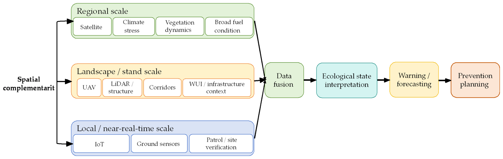
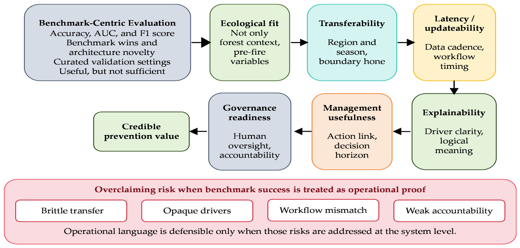
| Protocol Element | Analytical Implementation | Analytical Purpose |
|---|---|---|
| Prevention definition | Pre-ignition or pre-escalation decisions that reduce ignition probability, hazardous fuel/exposure, or warning delay. | Separates prevention from detection-only, suppression-only, and post-fire mapping studies. |
| Core evidence requirement | Full text or open full-text version available for methods, data, validation, findings, and limitations extraction. | Ensures that evaluative claims are based on extractable full-text evidence rather than abstract-level information alone. |
| Extraction fields | Region, ecosystem, inputs, method, comparator, validation, horizon, uncertainty, decision target, limitations. | Supports technical and operational synthesis rather than topic classification. |
| Evidence grading | Strong, moderate, limited, contextual, based on validation rigor, transfer testing, and decision linkage. | Prevents model accuracy from being treated as operational prevention value. |
| Reference expansion | Classical fire models, lightning, fire-weather indices, remote sensing, WUI, governance, and global AI case studies. | Internationalizes the evidence base and connects AI to established fire science. |
Disclaimer/Publisher’s Note: The statements, opinions and data contained in all publications are solely those of the individual author(s) and contributor(s) and not of MDPI and/or the editor(s). MDPI and/or the editor(s) disclaim responsibility for any injury to people or property resulting from any ideas, methods, instructions or products referred to in the content. |
© 2026 by the authors. Licensee MDPI, Basel, Switzerland. This article is an open access article distributed under the terms and conditions of the Creative Commons Attribution (CC BY) license.
Share and Cite
Feng, S.; Liang, H.; Liu, X. From Ecological Monitoring to Prevention Decision Support: A Critical Review of Artificial Intelligence for Forest Fire Prevention. Forests 2026, 17, 817. https://doi.org/10.3390/f17070817
Feng S, Liang H, Liu X. From Ecological Monitoring to Prevention Decision Support: A Critical Review of Artificial Intelligence for Forest Fire Prevention. Forests. 2026; 17(7):817. https://doi.org/10.3390/f17070817
Chicago/Turabian StyleFeng, Shuwei, Hao Liang, and Xiaodong Liu. 2026. "From Ecological Monitoring to Prevention Decision Support: A Critical Review of Artificial Intelligence for Forest Fire Prevention" Forests 17, no. 7: 817. https://doi.org/10.3390/f17070817
APA StyleFeng, S., Liang, H., & Liu, X. (2026). From Ecological Monitoring to Prevention Decision Support: A Critical Review of Artificial Intelligence for Forest Fire Prevention. Forests, 17(7), 817. https://doi.org/10.3390/f17070817

