Article

Prediction of Potential Forest Risk Areas for Phytopythium helicoides in China Under Climate Change Based on Maximum Entropy Modeling

1
Co-Innovation Center for the Sustainable Forestry in Southern China, Nanjing Forestry University, Nanjing 210037, China
2
Department of Customs Inspection and Quarantine, Shanghai Customs University, Shanghai 200120, China
3
College of Information Science and Technology & College of Artificial Intelligence, Nanjing Forestry University, Nanjing 210037, China
4
College of Mechanical and Electronic Engineering, Nanjing Forestry University, Nanjing 210037, China
*
Author to whom correspondence should be addressed.
These authors contributed equally to this work.
Forests 2026, 17(5), 626; https://doi.org/10.3390/f17050626
Submission received: 17 April 2026 / Revised: 15 May 2026 / Accepted: 19 May 2026 / Published: 21 May 2026
(This article belongs to the Special Issue Pathogenic Fungi in Forests: 2nd Edition)

Abstract

Despite the growing threat of Pythium helicoides to forest plantations in China, a nationwide assessment of climatic suitability remains unavailable, limiting the development of preventive strategies. This study applied the Maximum Entropy model combined with geographic information system analysis to predict the potential distribution and suitable habitats of the pathogen across China. The model was constructed using occurrence records from the Global Biodiversity Information Facility and published literature, together with bioclimatic, topographic, and soil variables. Simulations were performed under current and future climate conditions throughout the twenty-first century across low, medium, and high emission scenarios. The model performed reliably, with Area Under the Curve values indicating favorable predictive accuracy across all periods. Habitat suitability was governed primarily by precipitation of the driest month, temperature annual range, and elevation. Under current conditions, highly suitable areas are concentrated in tropical and subtropical monsoon regions, particularly eastern Hainan and Taiwan. Under future scenarios, suitable habitats are projected to shift toward warm temperate regions while contracting overall, with plains, basin floors, and valleys retaining high suitability due to favorable moisture retention. Windward mountain slopes are generally unsuitable, although scattered medium-suitable habitats may form in lower-lying depressions with gentler slopes.

Graphical Abstract

1. Introduction

Phytopythium helicoides, an oomycete within the kingdom Oomycota, is a significant plant pathogen [1]. It is mainly distributed in Hebei, Shandong, Henan, Jiangsu, Guangdong, Fujian and other provinces in China, and has attracted considerable attention in forestry production. P. helicoides infects a broad range of hosts—including economically important forest trees (e.g., Eucalyptus spp., Populus spp.), nursery stocks, and cash crops such as Fragaria × ananassa and Nelumbo nucifera—posing a growing threat to forest health and plantation stability in China. It causes root rot and stem base rot, which can lead to substantial mortality in young forest plantations and significant economic losses in forestry production systems [2]. This limitation severely reduces forest trees and cash crop yields and quality, resulting in substantial economic losses in agricultural production [3]. Morphologically, the colonies on CMA medium exhibit a radial pattern with cottony aerial mycelia. The mycelia are well-developed and highly branched, measuring 1.5–9.2 μm in diameter. Sporangia are predominantly ovoid, rarely nearly spherical, and possess a single apical pore; intercalary sporangia occur occasionally. Nearly spherical sporangia range from 17 to 36 μm in diameter [4]. It should be noted that this species has recently been reclassified as Phytopythium helicoides based on phylogenetic studies; however, as the majority of occurrence records obtained from GBIF. Available online: https://www.gbif.org/zh/occurrence/search?offset=0&taxon_key=8188955 (accessed on 23 September 2025) and the literature are archived under P. helicoides, and to maintain consistency with the input data and existing references, P. helicoides is retained throughout this manuscript. This terminology choice does not affect the taxonomic identity or the validity of the distribution modeling.
In China’s forestry sector, P. helicoides has been increasingly implicated in mortality events in poplar (Populus spp.) and eucalyptus (Eucalyptus spp.) plantations—two dominant exotic tree species that account for over 70% of China’s fast-growing timber base [5]. The pathogen causes root rot and stem base rot, leading to growth reduction, windthrow, and stand decline in young plantations. Despite its growing economic impact, national-scale assessment of climatic suitability remains lacking, hindering the development of proactive forest health management strategies.
The ecological niche model (ENM) serves as an important tool in species distribution modeling and biogeography research. This model can predict potentially suitable areas for a species, evaluate habitat suitability, and infer potential transmission pathways based on known species distribution data and relevant environmental variable [6]. Among various ecological niche models, the MaxEnt model has become a mainstream method for species habitat analysis because it maintains high prediction accuracy and stability even with relatively limited data. Compared to earlier models such as Clime [7], Biocli [8], and Garp [9], the MaxEnt model exhibits greater adaptability and explanatory power in analyzing relationships between species distribution data and environmental factors, especially under limited sample sizes. In recent years, the MaxEnt model has been widely used to predict species’ potential suitable habitats, assess alien species invasion risks, and evaluate the impacts of climate change on biodiversity [10]. It has also yielded satisfactory results in predicting the distribution and suitable habitats of species such as tangerine pomelo [11], kiwi fruit [12], breadfruit [13], locust tree [14], and wolfberry [15], demonstrating the model’s good applicability for predicting geographically suitable habitats of species in China.
Currently, systematic studies predicting potential suitable areas for P. helicoides in China remain relatively limited. However, clarifying the current and future spatial distribution patterns of this pathogen is crucial for early warning, targeted regional prevention and control, and the development of quarantine strategies. Based on 37 valid distribution records collected across China and 11 key environmental variables, this study employed the MaxEnt model alongside GIS spatial analysis to simulate potential suitable areas for P. helicoides under current and future climate scenarios (SSP1-2.6, SSP2-4.5, and SSP5-8.5) for four periods (2021–2040, 2041–2060, 2061–2080, and 2081–2100). The main environmental factors influencing its distribution were also identified, providing a scientific basis for forest disease surveillance, quarantine regulation of forest seedlings, and adaptive forest management under climate change [16].
Despite the recognized impact of P. helicoides on key agricultural systems in China, a comprehensive, spatially explicit assessment of its current and future climatic suitability at the national scale remains scarce [17]. Most existing studies have focused on local outbreaks or specific host–pathogen interactions, with limited integration of multi-environmental predictors under climate change scenarios. Such a gap hinders the development of proactive and regionally tailored management strategies [18].
To address this, the present study employs the Maximum Entropy (MaxEnt) model, coupled with Geographic Information System (GIS) spatial analysis, to (1) identify the key environmental drivers shaping the current distribution of P. helicoides in China [19], (2) predict its potential suitable habitats under current and future climate scenarios [20], and (3) quantify shifts in suitable areas and distribution centroids under climate change [21]. By integrating climatic, topographic, and edaphic variables, this work aims to provide a high-resolution, forward-looking perspective on the pathogen’s biogeographic dynamics [22].
It should be noted that the model outputs generated in this study represent environmental suitability for Pythium helicoides based on climatic and environmental variables, rather than direct estimates of disease occurrence probability or epidemic intensity. The term “risk” used herein refers to spatial prioritization derived from suitability maps, serving as an extension for management implications. While true disease risk assessment would ideally incorporate additional biological and socioeconomic factors such as host distribution, forest trees and cash cropsping patterns, or trade pathways—which are not included in the current modeling framework—this study focuses primarily on the geospatial dimension of potential suitability. These limitations are acknowledged in the Discussion, and the findings are intended to provide a preliminary spatial guide for monitoring and quarantine planning, rather than a comprehensive risk forecast. This study provides information on environmental suitability and potential risks, and the risk management recommendations are derived from the suitability maps.
The outputs of this study are intended to support decision-making by forestry authorities, particularly in prioritizing regions for disease monitoring, regulating seedling movement, and integrating climate risk into forest protection planning.

2. Materials and Methods

2.1. Species Occurrence Data

The geographical distribution records of P. helicoides were obtained from the Global Biodiversity Information Facility (GBIF, Available online: https://www.gbif.org/ (accessed on 23 September 2025)) and relevant published literature. A total of 37 occurrence records were collected, predominantly located in eastern China. To minimize spatial autocorrelation and sampling bias, a two-step spatial filtering procedure was implemented in ArcGIS 10.8:
Spatial thinning: Given the spatial resolution of the climate data (approx. 5 km), a 5 km × 5 km grid was overlaid on the occurrence points. Within each grid cell, only one record was retained to ensure spatial independence.
Bias correction using Target-Group Background (TGB): To account for uneven survey effort, background points (n = 10,000) were sampled from GBIF occurrence records of congeneric Pythium species within East Asia (China, Japan, Korea, and Mongolia. Records were retrieved using the genus keyword “Pythium” and filtered by (1) coordinate uncertainty ≤ 10 km; (2) collection years 1950–2020; and (3) exclusion of cultivated/misidentified records. This approach matches the sampling effort of the presence data and reduces model overfitting to geographic bias [23].

2.2. Data Acquisition and Processing

A total of 37 environmental variables were initially considered, including 19 bioclimatic variables from WorldClim version 2.1 (http://www.worldclim.org). The data used are from WorldClim and the spatial resolution is 2.5′. 3 topographic variables (elevation, slope, aspect) from the same source, and 15 soil variables from the FAO Soil Database (https://www.fao.org/faostat/). Future climate projections for four periods (2021–2040, 2041–2060, 2061–2080, 2081–2100) under three Shared Socioeconomic Pathways (SSP1-2.6, SSP3-7.0, SSP5-8.5) were also downloaded from the Sixth Emission Report of the IPCC.
Variable screening was performed to avoid multicollinearity and overfitting. Pearson correlation coefficients were calculated for all variable pairs using Origin 2021. When r     0.85 , the variable with lower contribution in a preliminary MaxEnt 3.4.1 run was excluded (Figure 1). After screening, 11 variables with low correlation and high ecological relevance were retained for final modeling (Table 1) [24].

2.3. Study Area and Background Extent (M Region)

The study area (M region) was defined as the geographic extent within which the species is presumed to be able to disperse and establish under current and future climatic conditions and based on the buffer zone of the known distribution points (500 km) and the superimposition with the related ecological areas, an ecologically reasonable area has been obtained. Based on the known distribution of P. helicoides and its host plants in China, we delineated the M region as mainland China plus Taiwan and Hainan Island, bounded by 73–135° E and 18–54° N. This region encompasses all known occurrence points and represents a plausible accessible area for the pathogen under natural and human-assisted dispersal scenarios.

2.4. Background Point Selection Strategy

To improve model realism and reduce geographic bias, we adopted a target-group background (TGB) approach. Background points (n = 10,000) were randomly sampled from the occurrence records of multiple Pythium species within the same genus and geographic region, obtained from GBIF. The background points are derived from the distribution records of the same species (Pythium) in East Asia, thereby matching the sampling efforts and enabling the model to focus on differentiating environmental suitability rather than sampling bias. This strategy ensures that background points reflect similar survey effort and environmental coverage as the presence data, thereby reducing model overfitting to sampling artifacts.

2.5. Construction of the MaxEnt Model

The screened geographical distribution data of P. helicoides and corresponding environmental variables were imported into Maxent v.3.4.1. Twenty-five percent of the species occurrence records were randomly selected as the test dataset. The model was run 10 times, and the ROC curve was generated. The replication method was configured as “Bootstrap”. The prediction results were output in logistic format as an ASC file [25], and the contributions of environmental variables to the model were evaluated. All other parameters remained at their default settings.

2.6. Model Accuracy Testing

The area under the curve (AUC) value for the ROC curve was calculated using MaxEnt 3.4.1. An AUC value ≤ 0.5 suggests a reverse prediction (i.e., a negative correlation between observed and predicted values), ≤0.6 indicates failure, ≤0.7 reflects poor performance, and ≤0.8 denotes acceptable performance, an AUC value ≤ 0.9 indicates good performance, while a value > 0.9 indicates favorable performance. Finally, environmental factors were selected based on their contribution rate and correlation. Specifically, factors with an absolute correlation coefficient (|r|) ≥ 0.85 and the factors with a higher contribution rate were retained for further analysis. The 11 environmental variables, with relatively high contribution rates were selected for the subsequent model construction. Among them, annual temperature range (BIO7), precipitation of the wettest month (BIO13), precipitation of the driest month (BIO14), and precipitation seasonality coefficient (BIO15) had the highest contribution rates [26].

2.7. Optimization of the MaxEnt Model

The unoptimized MaxEnt model is prone to prediction errors, which may compromise the transferability of results. To improve model accuracy and reproducibility, the following systematic optimization procedure was adopted in this study:
Variable Screening: Prior to modeling, environmental variables were preprocessed to remove highly correlated variables (Pearson correlation coefficient > 0.8), ensuring variable independence and reducing the risk of overfitting.
Parameter Optimization: The R package ENMeval was used to tune the feature class (FC) and regularization multiplier (RM). Specific settings were as follows:
Feature classes: Twelve common combinations were tested, including L (linear), Q (quadratic), H (hinge), P (product), and T (threshold) in various combinations (e.g., H, L, LQ, LQH, LQHP, LQHPT, LQP, LQPT, etc.).
Regularization multipliers: Twelve values (0.5, 1.0, …, 6.0) were tested, resulting in a total of 144 candidate models.
Model run settings: The model was trained for 50,000 iterations using 10,000 background points, with 10-fold cross-validation. A random selection of 75% of the data was used as the training set, while the remaining 25% was reserved for testing. The final results are presented as mean values. Model selection was based on the difference between training and testing AUC (AUC diff) and the 10% training omission rate (OR10), with the model exhibiting the smallest ΔAICc value chosen as the optimal model [27] (random seed).

2.8. Classification of Suitable Areas

The output results of the MaxEnt model were imported into ArcGIS 10.8 and reclassified according to the specified format to predict the potential suitable areas for P. helicoides. Combined with the geographical distribution data, suitability levels were classified into four categories using the natural breakpoint method: non-suitable area (0–0.078), low-suitable area (0.078–0.249), medium-suitable area (0.249–0.462), and high-suitable area (0.462–1.000). The areas of these zones were then calculated [28].

2.9. Changes in Potential Suitable Areas and Center of Gravity Shift

Using ArcGIS, the prediction results were binarized and reclassified to distinguish suitable areas from unsuitable ones (10% training percentile threshold). Subsequently, the raster data was converted to polygons with the “create multipart feature” option enabled, followed by an intersect operation for overlay analysis [29]. Finally, the polygon-to-raster conversion method was applied to quantify changes in potentially suitable areas. Based on projected shifts in species distributions under climate change, the grid cells were categorized as contraction areas (currently occupied but potentially lost in the future), expansion areas (currently unoccupied but potentially gained in the future), and stable areas (persistent under both current and future conditions). ArcGIS was employed to visualize the compositional changes in P. helicoides. A comparison of its current and projected future distributions reveals clear trends in the shifts in its range. The “Average Center” tool within the spatial statistics module was used to compute the central position, migration direction, and displacement distance of P. helicoides across different periods. To some extent, the shift in geographic distribution centers reflects how future climate conditions may affect P. helicoides [30].

3. Results and Analysis

3.1. Model Performance Results

The model parameters show that the LQHPT combination with an RM value of 2.5 yields the lowest delta AICc (Figure 2) and was therefore selected for the final model.
The ROC curve was derived from the MaxEnt model simulation results. The feature curve achieved an AUC of 0.960 (Figure 3), demonstrating strong discriminative ability of the model. The AUC (Area Under the Curve) value ranges from 0 to 1, with a higher value indicating greater model accuracy and reliability. An AUC below 0.6 is generally considered to reflect an unqualified prediction performance; the predictive performance is categorized as follows: poor for 0.6 ≤ AUC < 0.7, average for 0.7 ≤ AUC < 0.8, good for 0.8 ≤ AUC < 0.9, and favorable for 0.9 ≤ AUC < 1.0. An AUC of 1 indicates a perfect match between predicted and actual values. The results demonstrate an AUC of 0.960 for the ROC curve [26], indicating strong model performance in analysis and prediction. The predictive accuracy of the MaxEnt model was assessed using the AUC value, statistical significance, AIC value, and a 5% training omission rate. The AUC values exceeded 0.9, with a delta AICc of 0 and a 5% training omission rate of 0 (Table 2). The suitability predicted by the model based on the above data is both credible and accurate [31], making it applicable for forecasting the potentially suitable areas for P. helicoides.

3.2. Selection of Key Environmental Factors

The jackknife test results indicate that, when considered individually, the regularization training gain scores for Bio7 (annual temperature range), Bio13 (precipitation of the wettest month), Bio14 (precipitation of the driest month), and elev (elevation) all exceed 0.80 (Figure 4). This suggests that these four environmental variables exert the greatest influence on the distribution of P. helicoides. Based on the contribution rate and Jackknife test results, four key climate variables were selected and used to plot response curves. The key environmental variables influencing the distribution of P. helicoides are as follows: annual temperature range 9.32–35.09 °C, precipitation of the wettest month 196.24–802.61 mm, precipitation of the driest month 19.18–210.11 mm, and elevation −684.91 to 394.13 m.

3.3. Key Environmental Drivers of P. helicoides Distribution

Combining Pearson correlation analysis (Figure 5) with model contribution rate, 11 environmental variables were selected (Table 1). Through MaxEnt modeling, simulations at multiple temporal scales were conducted to assess potential suitable areas for P. helicoides. The results indicate that its distribution pattern is significantly influenced by climatic factors. Among all the environmental factors, Bio14 (minimum monthly precipitation), Bio7 (annual temperature range), and elev (elevation) exhibited the highest relative contributions, collectively accounting for 86.2% of the total—significantly greater than the sum of the remaining environmental factors [32]. The ranking results indicate that Bio14 (lowest monthly precipitation), elev (elevation), and t_gravel (percentage of crushed stone volume) are the primary variables, accounting for a cumulative importance of 81.6%. From this analysis, it is evident that Bio14 (minimum monthly precipitation) and elev (elevation) are the principal environmental factors shaping the geographic distribution of P. helicoides under current climatic conditions.

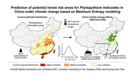
3.4. Present Suitability Map for P. helicoides

The current suitable distribution area of P. helicoides was predicted using the MaxEnt model (Figure 6). The current total suitable area for P. helicoides is 1,900,100 km2, accounting for 19.79% of China’s total land area. The total suitable area comprises 87.24 × 10⁴ km2 of low suitability, 65.66 × 10⁴ km2 of medium suitability, and 37.11 × 10⁴ km2 of high suitability. P. helicoides is primarily distributed in low-suitability regions of China, occupying approximately 9.91% of the total land area. It is primarily distributed in western Hebei, Shandong, eastern Henan, central and eastern Hubei, eastern Sichuan, Chongqing, and southern Guizhou. Areas of moderate severity account for 6.84% of the country’s land area, primarily distributed in Beijing, Tianjin, Hebei, Zhejiang, Anhui, central Guangxi, central Guangdong, and western Hunan. The highly suitable areas, comprising 3.87% of the country’s land area, are primarily concentrated in eastern Hainan and Taiwan, demonstrating a distinct pattern of geographical clustering. From the perspective of climate zones, suitable habitats are primarily distributed in tropical and subtropical monsoon climate regions.

3.5. Future Climate Distribution of P. helicoides

Table 3 summarizes the total suitable area and its grade composition in four periods (2021–2040, 2041–2060, 2061–2080, 2081–2100) under three SSP scenarios (SSP1-2.6, SSP3-7.0, SSP5-8.5). Generally speaking, compared with the current situation, the total suitable area in all scenarios shows a downward trend in the future, and the reduction in high and medium suitable areas is particularly significant. Under future climate scenarios, the suitable habitat range of P. helicoides in China is projected to gradually contract spatially, while unsuitable areas are expected to expand accordingly [33].
Based on the current and future suitability predictions (Figure S1) and the area statistics for each suitability class (Table 3), the response of P. helicoides to climate change was quantified. Under current climate conditions, the total suitable habitat area for P. helicoides in China is 1.9001 × 10⁶ km2. Under all future emission scenarios (SSP1-2.6, SSP3-7.0, and SSP5-8.5) and time periods (2021–2100), the total suitable area exhibits an overall declining trend compared to the current baseline, although with scenario-specific fluctuations (Table 3).
Under the low-emission SSP1-2.6 scenario, the total suitable area first decreases from the current level to 165.54 × 10⁴ km2 in 2041–2060, then recovers to 176.04 × 10⁴ km2 by 2081–2100. Under the medium-emission SSP3-7.0 scenario, a similar pattern is observed: the total suitable area drops to 164.34 × 10⁴ km2 in 2041–2060, followed by a partial recovery to 176.77 × 10⁴ km2 in 2081–2100. Under the high-emission SSP5-8.5 scenario, the total suitable area remains relatively stable before a late-century decline, reaching 174.74 × 10⁴ km2 in 2081–2100. Notably, across all three scenarios, the moderately and highly suitable areas consistently decrease relative to the current situation, indicating that climate change disproportionately reduces high-quality habitats even when total suitable area shows temporary recovery.
Spatially, the distribution of suitable habitats undergoes progressive reorganization (Figure 6). During the early-century period (2021–2040), moderately to highly suitable areas under SSP1-2.6 are concentrated in two main regions: the middle–upper Yangtze River Plain (including the Jianghan–Dongting–Poyang Lake floodplain; 30–32° N, 113–120° E) and the Pearl River Delta (23–25° N, 110–115° E). Under SSP3-7.0 and SSP5-8.5, the initial spatial pattern is similar to that of SSP1-2.6, but high-suitability patches become more fragmented, especially in the Pearl River Delta region.
By the mid-century period (2041–2060), the spatial pattern diverges among scenarios. Under SSP1-2.6, high-suitability areas expand westward along the Yangtze River into the eastern Sichuan Basin (30° N, 105–107° E) and eastward toward the Yangtze River Delta coastal region. The northern boundary of high suitability in the Pearl River Estuary extends across the Nanling Mountains to approximately 25° N in southern Hunan. Under SSP3-7.0, high-suitability areas contract northward: the formerly suitable zone north of 32° N disappears, and the high-suitability area in the Sichuan Basin shrinks by more than 30%. Under SSP5-8.5, a clear northward shift emerges: the Shandong Peninsula (36° N, 118–122° E) transitions into high suitability, while several coastal areas in southern China shift from high to low suitability.
During the late-century period (2061–2080), the expansion of suitable areas peaks under SSP1-2.6. Under SSP3-7.0, the entire suitable area shifts southward by 1–1.5 degrees of latitude in mid-to-high latitudes, from approximately 32° N to 30.5° N. In coastal southern China, increased summer extreme heat (>35 °C) drives a cascading downgrade of suitability classes: high → medium → low. Under SSP5-8.5, suitable areas extend eastward along the 35° N latitude toward the Korean Peninsula border and westward into the Guanzhong–Tianshui Basin (34–35° N, 105–108° E).
By the end of the century (2081–2100), under SSP1-2.6, the total suitable area and its spatial distribution remain nearly unchanged from 2061 to 2080, suggesting that the system reaches a quasi-equilibrium under low radiative forcing. Under SSP3-7.0, suitable mid- and high-altitude habitats contract to the hilly basin region encompassing “Xiangjiang–northern Guangxi–northern Guangdong” (24–30° N, 108–118° E), with a total area reduction of approximately 25% relative to 2061–2080. Under SSP5-8.5, the northernmost limit of high suitability shifts to 33.5–36° N, 105–122° E, covering the Huang-Huai-Hai Plain and the southern Shandong–Liaoning Peninsula. In contrast, most of South China (22–26° N) becomes entirely unsuitable, forming a “north–south inversion” pattern where traditional southern strongholds are replaced by newly suitable northern regions.
Taken together, these results demonstrate that future climate change will drive a net contraction of suitable habitat for P. helicoides, accompanied by a northward shift in the distribution centroid and a progressive downgrading of habitat quality in southern China. The magnitude of these changes increases with emission intensity, with SSP5-8.5 producing the most radical spatial reconfiguration.
Based on the overlay analysis of current and future suitability maps (Figure S2) and the area statistics of different change types (Table 4), the spatiotemporal dynamics of suitable habitats for P. helicoides under three Shared Socioeconomic Pathways (SSPs) were quantified. The overall trend across all scenarios is characterized by a net contraction of total suitable area, accompanied by localized northward expansion—a pattern that has been widely documented in MaxEnt-based studies of climate-sensitive pathogens and forest pests in East Asia (e.g., Heterobasidion spp., Bursaphelenchus xylophilus) [34].
Under the low-forcing SSP1-2.6 scenario, the total suitable area fluctuates over time but remains consistently lower than the current baseline (190.01 × 10⁴ km2), exhibiting a “contraction–recovery–recontraction” pattern (Table 4). The net loss is most pronounced during 2041–2060 (Δ = −17.78 × 10⁴ km2), after which a partial recovery occurs in 2061–2080. Expansion areas are mainly concentrated in the middle and lower Yangtze River Plain and the Pearl River Delta, whereas contraction primarily affects marginal zones in northern and western China. Spatially, the Jianghan Plain and the middle Yangtze River basin remain a stable core high-suitability region throughout the 21st century—a result consistent with the centroid stability observed in Figure 7. The northern boundary of suitable habitat gradually shifts northward from the Huai River line to the southern Huai-Huai region by 2081–2100, with isolated medium- and low-suitability patches appearing on the Shandong Peninsula. In contrast, the southern boundary remains stable, and the high-suitability areas on Hainan Island and Taiwan persist. This pattern indicates that under moderate warming, P. helicoides undergoes slow, boundary-level northward migration without fundamental rearrangement of its core distribution.
Under the medium-forcing SSP3-7.0 scenario, the dynamics become more pronounced and nonlinear. An initial expansion phase (2021–2040) is followed by a severe contraction (2041–2060), then a modest recovery (2061–2100), yet the total suitable area never returns to current levels (Table 4). The most striking spatial change is the emergence of a “mid-latitude expansion corridor” between 30 and 35° N, encompassing the southern North China Plain, the Guanzhong Plain, and the Han River Valley. This corridor is characterized by the simultaneous release from winter cold constraints (warmer winters reduce overwintering mortality) and the maintenance of summer water-heat conditions within the pathogen’s tolerance window—a mechanism analogous to that reported for Phytophthora cinnamomi under moderate warming scenarios. Concurrently, traditional high-incidence regions in South China (south of 25° N) experience widespread habitat downgrading: high-suitability areas become fragmented or disappear entirely, being replaced by medium- or low-suitability classes.
The net result is a substantial northward shift in the habitat centroid and the formation of a “dual-core” (north–south) distribution pattern, where the mid-latitude corridor acts as a secondary core in addition to the persistent Jianghan core. This pattern suggests that under medium forcing, climate change acts as a filter that reshapes the pathogen’s geography by both eliminating southern strongholds and creating novel northern hotspots. Under the high-forcing SSP5-8.5 scenario, the most dramatic and regime-shifting changes occur. Unlike the gradual boundary shifts under lower scenarios, SSP5-8.5 drives a spatial replacement of the entire suitable area—a phenomenon best described as “north–south inversion.” During 2061–2080, the expansion area reaches its maximum across all scenarios (16.842 × 10⁴ km2, Table 4), with new suitable habitats emerging in the North China Plain, the southern part of Northeast China (Liaohe River Basin, up to ~42° N), and even mountain-front oases in the northern Tianshan Mountains of Xinjiang. By the end of the century (2081–2100), most of South China (22–26° N)—traditionally the high-suitability zone—contracts to unsuitable or only marginally suitable conditions. In contrast, the Huang-Huai-Hai Plain, the Huaihai region, and the southern Liaodong Peninsula (33.5–38° N) are transformed into contiguous high-suitability areas.
This inversion is driven by two asymmetric climate responses: (1) in southern China, extreme summer heatwaves (>35 °C) and intensified but episodic rainfall lead to shortened soil saturation periods and exceedance of the pathogen’s upper thermal limit (~36 °C); (2) in northern China, winter temperature increases of 4–5 °C prevent soil freezing, while a 15–20% rise in precipitation ensures adequate spring moisture—conditions that favor overwintering and early-season pathogen proliferation. Similar “southern loss–northern gain” patterns have been reported for Pythium ultimum in Europe and Phytophthora sojae in North America under RCP8.5 [35], but the magnitude and spatial extent observed here for P. helicoides under SSP5-8.5 are particularly striking. This scenario implies that under extreme warming, the traditional disease-prone regions of southern China may become climate refugia for the host but not for the pathogen, whereas warm-temperate northern China would face unprecedented forest disease risks, necessitating a fundamental reorientation of quarantine and monitoring efforts.
In summary, the quantitative dynamics derived from Table 4 and Figure S2 reveal a clear emission-dependent hierarchy of habitat change for P. helicoides: under SSP1-2.6, slow boundary migration with stable core; under SSP3-7.0, corridor formation and dual-core emergence; under SSP5-8.5, spatial inversion with northward replacement. These findings underscore the necessity of scenario-specific risk assessment and adaptive forest management strategies in response to ongoing climate change.

3.6. Centroid Migration of P. helicoides

Analysis of the distribution changes in P. helicoides across past, present, and future periods indicates that, under different climate scenarios, the migration distance and direction of its suitable habitat centroid vary. Overall, however, a southward shift is projected over time. The change in the center of mass is influenced by the area weight. The area in the north has increased while that in the south has decreased more significantly (Table 4). The center of mass may still shift southward. The suitable habitat for P. helicoides is currently concentrated in the core area of Wuchang District, Wuhan City, with a central coordinate of 114°18′ E, 30°36′ N (Figure 7). Under the SSP1-2.6 scenario, the centroid of the suitable area shifted initially toward the southwest, followed by an eastward movement. Under SSP3-7.0, the centroid moved first eastward then westward, ultimately remaining within Wuhan City (114°218′ E, 30°659′ N). Under SSP5-8.5, the centroid shifted eastward and was finally located in Ezhou City (114°349′ E, 30°468′ N).

4. Discussion

4.1. Dominance of Bio14: The Dry-Month Precipitation Bottleneck

Our results identify precipitation of the driest month (Bio14) as the predominant factor governing the distribution of P. helicoides, contributing 72.4% to the model. This contrasts with studies on other Pythium species (e.g., P. aphanidermatum) [36], which are often more limited by growing-season moisture (Bio18) or mean temperature. The critical role of Bio14 underscores a survival bottleneck specific to the East Asian monsoon climate: the winter–spring drought period. As an oomycete, P. helicoides depends on persistent soil moisture for oospore survival and germination. Bio14 directly determines the severity and duration of soil moisture deficit during this vulnerable stage. Regions with moderate dry-season rainfall (e.g., eastern Hainan and Taiwan) retain sufficient residual moisture to sustain the pathogen, whereas areas with pronounced winter–spring drought cannot support stable populations, even under humid summer conditions. This insight shifts the monitoring focus from total annual precipitation to seasonal moisture stress and suggests that irrigation or soil moisture conservation during dry intervals could mitigate establishment in marginal zones.

4.2. Southern Contraction Under High-Emission Scenarios

Contrary to the expectation that warming uniformly drives poleward expansion, our projections under SSP5-8.5 show a pronounced contraction of suitable habitat south of 25° N. This “southern loss” occurs because future climate conditions in these tropical margins exceed the pathogen’s thermal and hydrological tolerance thresholds. Increasing frequency of extreme summer temperatures (>35 °C) likely inhibits mycelial growth, while more intense but episodic rainfall enhances surface runoff, shortening the soil saturation period required for infection. Consequently, combined heat stress and altered hydrology render these regions unsuitable for P. helicoides establishment. This pattern aligns with the “High-temperature refuge” hypothesis [37] noted in other pathosystems. Practically, traditional disease hotspots in South China may experience reduced pathogen pressure under high-emission futures, permitting a strategic reallocation of monitoring resources.

4.3. Local Expansion Within Overall Contraction

Although the total suitable area for P. helicoides is projected to decline across all scenarios, we detected notable northward expansion into specific regions such as the Huang-Huai Plain, Jianghan Basin, and parts of Northeast China. This “local expansion amid overall contraction” arises because climate change differentially alleviates former constraints in these areas: warmer winters reduce cold-induced mortality, and modified precipitation regimes provide adequate soil moisture during key infection windows without the extreme drought or heat stress observed in the south. However, these newly suitable habitats are often fragmented and cannot fully offset losses in core southern areas. The result is a more fragmented and dynamic risk landscape. Enhanced surveillance and quarantine measures are therefore warranted along major agricultural corridors in northern China, where the pathogen could colonize previously unaffected forest trees and cash cropsping systems.

4.4. Differences and Similarities with Traditional Views

The conventional view suggests that climate warming drives pathogenic bacteria toward higher latitudes, creating “climate refuges.” However, in the South Asian tropical region within 22–26° N, extensive range contraction was observed. This contrasts with the northward expansion pattern of P. ultimum reported in Europe, suggesting the following: (1) When temperatures rise beyond the pathogen’s upper thermal limit (approximately 36 °C), the combined influence of heat and moisture reduces its survival. (2) The rise in winter temperatures at the tropical margin disrupts the “Cold temperature suppression” mechanism [38], while extreme summer heat and humidity shorten the soil moisture accumulation window, leading to a net increase in climatic discomfort. This finding supports the “High-temperature refuge” hypothesis, indicating that under high-emission scenarios, traditional disease-prone regions in South China may shift toward becoming a “climate filter zone,” whereas the warm temperate zone within 32–38° N would emerge as the primary potentially suitable area.

4.5. Stable Centroid Versus Shifting Boundaries

A notable finding is the relative stability of the habitat centroid in the Jianghan Plain (Wuhan region) across all climate scenarios, despite considerable shifts in distribution boundaries. This indicates that the central Yangtze River basin maintains an optimal, buffered combination of moderate temperature seasonality (Bio7) and seasonally balanced moisture (Bio14, Bio13). In contrast, the northern distribution boundary exhibits greater mobility, advancing into warmer temperate zones. This decoupling between a stable core and a dispersing front suggests that long-term monitoring and research should remain concentrated in endemic core areas like the Jianghan Plain to track pathogen evolution and epidemic behavior. Simultaneously, adaptive early-warning networks must be extended into the expanding northern zones to detect incursions and nascent outbreaks.

4.6. Refining Traditional Views on Pathogen Range Shifts

Our findings both align with and complicate the traditional narrative that climate warming promotes poleward pathogen movement [39]. While a northward expansion component exists, the dominant pattern is an overall range contraction driven by southern habitat loss. This contrasts with reports of certain temperate pathogens (e.g., P. ultimum in Europe) and underscores that range shifts are species-specific and mediated by local climatic thresholds. For P. helicoides in monsoonal China, the future distribution appears constrained from the south by excessive heat and from the west/north by moisture limitations, converging toward a narrower optimal belt. This supports a more nuanced model in which climate change acts as a “filter”, reshaping pathogen geography through simultaneous expansion and contraction. Such a perspective aids in prioritizing regions facing emergent risks (northern expansion zones) versus those where threats may stabilize or diminish (southern contraction zones).

4.7. Implications for Forest Disease Management and Quarantine

The spatial projections generated in this study offer several actionable insights for forest health management in China.
First, the persistent high suitability of the Jianghan Plain and the middle Yangtze River basin under all future scenarios identifies this region as a core endemic zone where long-term forest health monitoring and pathogen surveillance should be concentrated. This area supports extensive poplar and metasequoia plantations, which may serve as reservoirs for inoculum.
Second, the projected northward expansion into warm temperate regions—particularly the Huang-Huai Plain and the southern Liaodong Peninsula—suggests that previously low-risk forest areas may face increasing disease pressure. Forestry agencies in these regions should consider adjusting nursery sanitation protocols and incorporating P. helicoides into routine quarantine inspections for introduced seedlings.
Third, the contraction of suitable habitats south of 25° N under high-emission scenarios does not imply reduced vigilance; rather, it highlights the potential for pathogen range shifts that may alter disease dynamics unpredictably. The movement of infected planting stock from historically endemic areas to emerging northern zones could accelerate range expansion.
Finally, the strong influence of dry-season precipitation (Bio14) on habitat suitability suggests that irrigation management and site selection in forest nurseries could mitigate disease risk. Nurseries located in areas with pronounced winter–spring drought should implement soil moisture conservation practices to reduce pathogen survival.
These spatially explicit recommendations align with the goals of national forest protection programs and support the development of climate-smart forest management frameworks.

5. Considerations of Model Uncertainty

Although the MaxEnt model has demonstrated good performance in species distribution predictions, several sources of uncertainty remain in this study, which should be considered when interpreting the results.

5.1. Climate Model Source and Limitations

The future climate projections used in this study are based on output from a single global climate model (GCM), MIROC6. While MIROC6 performs well in simulating climatic variables over East Asian monsoon regions, structural differences among GCMs can lead to uncertainties in future climate projections. Future studies could employ multi-model ensembles or probabilistic frameworks to reduce biases associated with any single GCM.

5.2. Extrapolation Risk and Model Transferability

Under future climate scenarios, some environmental variables may fall outside the range present in the current training data, introducing extrapolation risk. Although the “clamping” function in MaxEnt was enabled to limit extreme extrapolation, uncertainty remains for projections into novel environmental space. Subsequent studies could incorporate multivariate extrapolation detection (e.g., MESS analysis) to identify and flag regions with high extrapolation risk.

5.3. Static Assumptions for Non-Climatic Variables

Soil properties and topographic variables were assumed to remain constant over time. This static assumption may overlook long-term pedogenic processes or anthropogenic land-surface changes that could influence species distributions. Future work could integrate dynamic soil or land-use models to improve ecological realism.

5.4. Small-Sample Bias and Model Generalization

Only 37 validated occurrence records were available for modeling, a relatively small sample size with uneven spatial coverage. This may lead to biased estimates of certain environmental response curves. Although the Target-Group Background approach was used to partially correct sampling bias, the model’s generalizability to unsampled regions should be interpreted cautiously. Updating and validating the model with more comprehensive survey data in the future is recommended.

6. Conclusions

The oomycete pathogen Phytopythium helicoides poses an increasing threat to forest plantations in China, particularly affecting poplar and eucalyptus stands that dominate the national fast-growing timber base. Despite its recognized economic impact, a nationwide, spatially explicit assessment of climatic suitability has long been unavailable, hindering the development of proactive forest health management and quarantine strategies. This study was therefore conducted to address this critical gap by quantifying the current and future potential distribution of the pathogen under climate change, thereby providing a scientific foundation for early warning systems and regional disease surveillance.
In this study, the MaxEnt model was used to predict the suitable habitat distribution of Phytopythium helicoides across China. The model performed reliably, with AUC values consistently above 0.9. Key environmental drivers were identified as precipitation of the driest month (Bio14), temperature annual range (Bio7), and elevation, which together accounted for 86.2% of the cumulative contribution.
Under current conditions, highly suitable habitats for this pathogen are concentrated in eastern Hainan and Taiwan. Future climate projections indicate an overall contraction of suitable areas but a northward expansion into warm temperate regions, with a southward shift in the habitat centroid. Plains, basins, and river valleys remain highly suitable due to favorable moisture retention, while mountainous areas are generally less suitable.
These findings carry important management implications. Suitability maps should be integrated into national forest disease early warning frameworks to prioritize monitoring efforts. Quarantine inspections for forest seedlings and nursery stocks transported from southern endemic areas to northern regions warrant strengthening, and long-term surveillance should focus on the Jianghan Plain and the Huang-Huai Plain as emerging risk zones. Furthermore, dry-season moisture availability should be considered in nursery site selection and irrigation planning to reduce pathogen survival in marginal habitats.
Looking ahead, future research should focus on four priorities. First, multi-model ensemble projections should be employed to reduce climate scenario uncertainty. Second, dynamic soil and land-use layers should be integrated to improve ecological realism. Third, the inclusion of host species distribution and socioeconomic factors—such as nursery stock trade networks and forest management practices—would move the analysis from environmental suitability toward comprehensive risk forecasting. Finally, systematic field surveys are needed to validate model predictions and update occurrence databases, thereby refining the spatial precision of habitat forecasts. Addressing these priorities will advance our ability to support climate-smart forest protection and sustainable plantation management in China.

Supplementary Materials

The following supporting information can be downloaded at: https://www.mdpi.com/article/10.3390/f17050626/s1.

Author Contributions

Y.K.: conceptualization, methodology, formal analysis, data curation, and writing (original draft, review, and editing). B.J.: Conceptualization, Data curation, Formal analysis, writing (review and editing). S.D.: formal analysis and data curation. C.Y.: writing (review and editing). Q.C.: Investigation and Project administration. T.D.: methodology, project administration, supervision, writing (review and editing). All authors have read and agreed to the published version of the manuscript.

Funding

This work was supported by National Natural Science Foundation of China (32471873), the STI 2030-Major Projects (2023ZD0405605), the China Postdoctoral Science Foundation (2024M751426), National Key R&D Program of China (2023YFD1401304), Natural Science Foundation of Jiangsu Province, China (BK20231291), and the Priority Academic Program Development of Jiangsu Higher Education Institutions.

Institutional Review Board Statement

Not applicable.

Informed Consent Statement

Not applicable.

Data Availability Statement

In this study, the original data used for analysis can all be obtained from the internet. The biological and climatic variables as well as the topographical variables are from WorldClim version 2.1 (http://www.worldclim.org), with a spatial resolution of 2.5’. The soil variables are from the FAO Soil Database (https://www.fao.org/faostat/).

Conflicts of Interest

All authors declare that there are no conflicts of interest.

References

  1. Ghimire, B.; Baysal-Gurel, F. A Diagnostic Guide to Phytopythium helicoides and Phytopythium vexans Causing Root and Crown Rot Diseases. Plant Health Prog. 2023, 24, 527–538. [Google Scholar] [CrossRef]
  2. Weiland, J.E.; Beck, B.R.; Davis, A. Pathogenicity and Virulence of Pythium Species Obtained from Forest Nursery Soils on Douglas-Fir Seedlings. Plant Dis. 2013, 97, 744–748. [Google Scholar] [CrossRef]
  3. Legrifi, I.; Taoussi, M.; Figuigui, J.A.; Lazraq, A.; Hussain, T.; Lahlali, R. Oomycetes Root Rot Caused by Pythium spp. and Phytophthora spp.: Host Range, Detection, and Management Strategies, Special Case of Olive Trees. J. Crop Health 2024, 76, 19–47. [Google Scholar] [CrossRef]
  4. Jesus, A.L.D.; GonçAlves, D.R.; Rocha, S.C.O.; Marano, A.V.; Jer?Nimo, G.H.; Souza, J.I.D.; Castilho Boro, M.; Pires-Zottarelli, C.L.A. Morphological and Phylogenetic Analyses of Three Phytopythium Species (Peronosporales, Oomycota) from Brazil. Cryptogam. Mycol. 2016, 37, 117–128. [Google Scholar] [CrossRef]
  5. Jung, T.; Pérez-Sierra, A.; Durán, A.; Horta, J.M.; Balci, Y.; Scanu, B. Canker and decline diseases caused by soil- and airborne Phytophthora species in forests and woodlands. Persoonia-Mol. Phylogeny Evol. Fungi 2018, 40, 182–220. [Google Scholar] [CrossRef]
  6. Gadelha, L.; Siracusa, P.C.D.; Dalcin, E.; Silva, L.A.E.; Siqueira, M.F.D. A survey of biodiversity informatics: Concepts, practices, and challenges. Wiley Interdiscip. Rev. Data Min. Knowl. Discov. 2020, 2020, e1394. [Google Scholar] [CrossRef]
  7. Hu, X.; Shi, Y.; Song, B.; Hu, L.; Zhao, Q.; Pang, D.; Yin, J.; Li, Y. Habitat distribution of major wildlife in the Sanjiangyuan National park under climate scenarios based on maxent modeling. Sci. Rep. 2025, 15, 39789. [Google Scholar] [CrossRef] [PubMed]
  8. Chiou, K.L.; Blair, M.E. Modeling niches and mapping distributions: Progress and promise of ecological niche models for primate research. In Spatial Analysis in Field Primatology: Applying GIS at Varying Scales; Cambridge University Press: Cambridge, UK, 2015. [Google Scholar]
  9. Davoudi Moghaddam, D.; Rahmati, O.; Haghizadeh, A.; Kalantari, Z. A modeling comparison of groundwater potential mapping in a mountain bedrock aquifer: QUEST, GARP, and RF models. Water 2020, 12, 679. [Google Scholar] [CrossRef]
  10. Tang, X.; Deng, Y.; He, Z.; Zhou, M.; Yuan, Y.; Zeng, K. Modelling the potential distribution and niche shift of Solenopsis invicta Buren under climate change and invasion process. Front. For. Glob. Change 2025, 8, 1659630. [Google Scholar] [CrossRef]
  11. Sabir, I.A.; Li, C.; Xu, C.; Hu, G.; Qin, Y. Agronomic and Environmental Suitability of ‘Tabtim Siam’ and ‘Xishi’ Pomelo in Dabu County (China). Horticulturae 2025, 11, 1290. [Google Scholar] [CrossRef]
  12. Gao, B.; Yuan, S.; Guo, Y.; Zhao, Z. Potential geographical distribution of Actinidia spp. and its predominant indices under climate change. Ecol. Inform. 2022, 72, 101865. [Google Scholar] [CrossRef]
  13. Pradhan, A.; Adhikari, D. Predicting the distribution of suitable habitats for pandanus unguifer hook.f.—A dwarf endemic species from sikkim himalayas, through ecological niche modeling. Int. J. Conserv. Sci. 2020, 11, 145–152. [Google Scholar]
  14. Liu, Y.; Yang, Q.; Li, S.; Zhang, Y.; Xiang, Y.; Yang, Y.; Zhang, J. Spatiotemporal Dynamics of Ilex macrocarpa Distribution Under Future Climate Scenarios: Implications for Conservation Planning. Forests 2025, 16, 370. [Google Scholar] [CrossRef]
  15. Li, J.; Deng, C.; Duan, G.; Wang, Z.; Zhang, Y.; Fan, G. Potentially suitable habitats of Daodi goji berry in China under climate change. Front. Plant Sci. 2023, 14, 1279019. [Google Scholar] [CrossRef]
  16. Morin, C.W.; Semenza, J.C.; Trtanj, J.M.; Glass, G.E.; Boyer, C.; Ebi, K.L. Unexplored Opportunities: Use of Climate- and Weather-Driven Early Warning Systems to Reduce the Burden of Infectious Diseases. Curr. Environ. Health Rep. 2018, 5, 430–438. [Google Scholar] [CrossRef]
  17. Ren, L.Y.; Wen, K.; Cheng, B.P.; Jin, J.H.; Srivastava, V.; Chen, X.R. Rapid detection of the phytopathogenic oomycete Phytopythium helicoides with a visualized loop-mediated isothermal amplification assay. Braz. J. Microbiol. 2025, 56, 563–572. [Google Scholar] [CrossRef]
  18. Gallego-Tévar, B.; Gil-Martínez, M.; Perea, A.; Pérez-Ramos, I.M.; Gómez-Aparicio, L. Interactive Effects of Climate Change and Pathogens on Plant Performance: A Global Meta-Analysis. Glob. Change Biol. 2024, 30, e17535. [Google Scholar] [CrossRef] [PubMed]
  19. Shikano, I.; Cory, J.S. Impact of Environmental Variation on Host Performance Differs with Pathogen Identity: Implications for Host-Pathogen Interactions in a Changing Climate. Sci. Rep. 2015, 5, 15351. [Google Scholar] [CrossRef]
  20. Chang, X.; Feng, S.; Ullah, F.; Zhang, Y.; Zhang, Y.; Qin, Y.; Nderitu, J.H.; Dong, Y.; Huang, W.; Zhang, Z.; et al. Adapting distribution patterns of desert locusts, Schistocerca gregaria in response to global climate change. Bull. Entomol. Res. 2025, 115, 84–92. [Google Scholar] [CrossRef] [PubMed]
  21. Li, F.; Lv, L.; Bao, S.; Cai, Z.; Fu, S.; Shi, J. Evaluation and Application of the MaxEnt Model to Quantify L. nanum Habitat Distribution Under Current and Future Climate Conditions. Agronomy 2025, 15, 1869. [Google Scholar] [CrossRef]
  22. Van de Vuurst, P.; Qiao, H.; Soler-Tovar, D.; Escobar, L.E. Climate change linked to vampire bat expansion and rabies virus spillover. Ecography 2024, 2024, e06714. [Google Scholar] [CrossRef] [PubMed]
  23. Phillips, S.J.; Dudík, M.; Elith, J.; Graham, C.H.; Lehmann, A.; Leathwick, J.; Ferrier, S. Sample selection bias and presence-only distribution models: Implications for background and pseudo-absence data. Ecol. Appl. 2009, 19, 181–197. [Google Scholar] [CrossRef]
  24. Shen, S.; Zhang, X.; Jian, S. The Distributional Range Changes of European Heterobasidion Under Future Climate Change. Forests 2024, 15, 1863. [Google Scholar] [CrossRef]
  25. Ma, R.; Li, C.; Tian, H.; Zhang, Y.; Feng, X.; Li, J.; Hu, W. The current distribution of tick species in Inner Mongolia and inferring potential suitability areas for dominant tick species based on the MaxEnt model. Parasit. Vectors 2023, 16, 286. [Google Scholar] [CrossRef]
  26. Zhang, J.; Li, X.; Li, S.; Yang, Q.; Li, Y.; Xiang, Y.; Yao, B. MaxEnt Modeling of Future Habitat Shifts of Itea yunnanensis in China Under Climate Change Scenarios. Biology 2025, 14, 899. [Google Scholar] [CrossRef]
  27. Fu, C.; Wen, X.; Shi, Z.; Rui, L.; Jiang, N.; Zhao, G.; Wang, R.; Zhao, J.; Yang, Y. Potential distribution prediction of Ceracris kiangsu Tsai in China. Sci. Rep. 2024, 14, 13375. [Google Scholar] [CrossRef]
  28. Chen, S.; Jiang, Z.; Song, J.; Xie, T.; Xue, Y.; Yang, Q. Prediction of potential habitat of Verbena officinalis in China under climate change based on optimized MaxEnt model. Front. Plant Sci. 2025, 16, 1563070. [Google Scholar] [CrossRef] [PubMed]
  29. Sun, S.; Deng, Z. Analysis of a Potentially Suitable Habitat for Solanum aculeatissimum in Southwest China Under Climate Change Scenarios. Plants 2025, 14, 1979. [Google Scholar] [CrossRef]
  30. Dong, P.; Wang, L.; Wang, L.; Lei, M.; Qiu, D.; Bai, G.; Guo, F.-X.; Chen, Y. Investigating the distributional response of the rare and endangered plant Fritillaria przewalskii to climate change based on optimized MaxEnt model. Sci. Rep. 2025, 15, 35939. [Google Scholar] [CrossRef] [PubMed]
  31. Ding, Y.; Yang, Y.; Peng, X.; Wang, J.; Wu, M.; Zhang, Y.; Liu, X.; Peng, P. Habitat Suitability and Driving Factors of Cycas panzhihuaensis in the Hengduan Mountains. Plants 2025, 14, 2797. [Google Scholar] [CrossRef]
  32. Jaturapruek, R.; Fontaneto, D.; Maiphae, S. The influence of environmental variables on bdelloid rotifers of the genus Rotaria in Thailand. J. Trop. Ecol. 2020, 36, 267–274. [Google Scholar] [CrossRef]
  33. Fan, Y.; Zhang, X.; Yang, J.; Yang, J.; Zhang, H.; Yang, B.; Li, X. Prediction of global potential distribution and assessment of habitat suitability for Xanthium spinosum driven by climate change. Front. Plant Sci. 2025, 16, 1690546. [Google Scholar] [CrossRef]
  34. Xiao, Y.; Guo, Q.; Xie, N.; Yuan, G.; Liao, M.; Gui, Q.; Ding, G. Predicting the global potential distribution of Bursaphelenchus xylophilus using an ecological niche model: Expansion trend and the main driving factors. BMC Ecol. Evol. 2024, 24, 48. [Google Scholar] [CrossRef]
  35. McCoy, A.G.; Belanger, R.R.; Bradley, C.A.; Cerritos-Garcia, D.G.; Garnica, V.C.; Giesler, L.J.; Grijalba, P.E.; Guillin, E.; Henriquez, M.A.; Kim, Y.M. A global-temporal analysis on Phytophthora sojae resistance-gene efficacy. Nat. Commun. 2023, 14, 6043. [Google Scholar] [CrossRef] [PubMed]
  36. Al-Sadi, A.; Al-Masoudi, R.; Al-Habsi, N.; Al-Said, F.; Al-Rawahy, S.; Ahmed, M.; Deadman, M. Effect of salinity on pythium damping-off of cucumber and on the tolerance of Pythium aphanidermatum. Plant Pathol. 2010, 59, 112–120. [Google Scholar] [CrossRef]
  37. Gsell, A.S.; Biere, A.; de Boer, W.; de Bruijn, I.; Eichhorn, G.; Frenken, T.; Geisen, S.; van Der Jeugd, H.; Mason-Jones, K.; Meisner, A. Environmental refuges from disease in host–parasite interactions under global change. Ecology 2023, 104, e4001. [Google Scholar] [CrossRef] [PubMed]
  38. Urayama, S.-I.; Takaki, Y.; Nunoura, T. FLDS: A comprehensive dsRNA sequencing method for intracellular RNA virus surveillance. Microbes Environ. 2016, 31, 33–40. [Google Scholar] [CrossRef]
  39. Bebber, D.P.; Ramotowski, M.A.; Gurr, S.J. Crop pests and pathogens move polewards in a warming world. Nat. Clim. Change 2013, 3, 985–988. [Google Scholar] [CrossRef]
Figure 1. Flow chart.
Forests 17 00626 g001
Figure 2. Optimized MaxEnt: aicc vs. feature and regularization.
Forests 17 00626 g002
Figure 3. ROC-AUC of MaxEnt.
Forests 17 00626 g003
Figure 4. Dominant-factor response curve. (A). Jackknife analysis result. (B). Annual range of temperature. (C). The monthly precipitation of the wettest month. (D). The lowest monthly precipitation. (E). Elevation.
Forests 17 00626 g004
Figure 5. Pearson correlation analysis.
Forests 17 00626 g005
Figure 6. The current distribution of potential suitable areas for P. helicoides. Note: The map is based on the standard map of GS (2022) 1873, and the map has not been modified.
Forests 17 00626 g006
Figure 7. Shifts in the Suitable Habitat Centroid of P. helicoides under Climate Change.
Forests 17 00626 g007
Table 1. Key environmental drivers in MaxEnt modeling.
Environmental
Variable
DecriptionPerent
Contribution
Permutation Importance
Bio14The lowest monthly precipitation72.435.8
Bio7Annual range of temperature8.15.3
elevelevation5.732
t_gravelPercentage of crushed stone volume5.413.8
Bio13The monthly precipitation of the wettest month3.24.2
t_textureTopsoil texture1.92.5
slopeSlope gradient1.92.1
t_espSlope orientation0.41.8
bio15Seasonal variation in precipitation0.40.9
aspectAspect0.31
t_siltSilt content0.20.6
Table 2. AUC-based Predictions of P. helicoides Habitat under Climate Scenarios.
Climate Change ScenarioYearAUC Value
Current1970–20000.974
2021–20400.976
2041–20600.978
scenario SSP1-2.62061–20800.976
2081–21000.977
2021–20400.975
2041–20600.979
scenario SSP3-7.02061–20800.978
2081–21000.978
2021–20400.979
2041–20600.975
scenario SSP5-8.52061–20800.979
2081–21000.976
Table 3. Habitat shifts in P. helicoides under climate change scenarios.
Climate ScenarioArea Unit (×104 km2)
Unsuitable HabitatSightly Suitable HabitatModerately Suitable HabitatHighly Suitable HabitatTotal Suitable Habitat
SSP1-2.6
2021–2040
755.0387.4962.8433.08183.41
SSP1-2.6
2041–2060
772.9082.7552.1530.64165.54
SSP1-2.6
2061–2080
755.8190.7557.1334.75182.63
SSP1-2.6
2081–2100
762.4085.5353.7336.77176.03
SSP3-7.0
2021–2040
739.5686.4967.0045.38198.87
SSP3-7.0
2041–2060
774.1079.9354.6529.76164.34
SSP3-7.0
2061–2080
756.3494.1954.1233.77182.08
SSP3-7.0
2081–2040
761.6791.5953.0332.15176.77
SSP5-8.5
2021–2040
752.4790.9960.6534.32185.96
SSP5-8.5
2041–2060
753.9788.9460.7334.80184.47
SSP5-8.5
2061–2080
748.4692.8658.3238.79189.97
SSP5-8.5
2081–2100
763.7184.9556.8032.99174.74
Table 4. Future climate suitability projections for P. helicoides.
Decades ScenariosPredicted Area Unit: ×104 km2
SuitableContractionGain
2021–2040 SSP1-2.6 vs. current172.80411.00510.380
2041–2060 SSP1-2.6 vs. current161.25022.4984.619
2061–2080 SSP1-2.6 vs. current172.49311.3479.949
2081–2100 SSP1-2.6 vs. current168.38915.4187.256
2021–2040 SSP3-7.0 vs. current178.9294.97419.304
2041–2060 SSP3-7.0 vs. current161.51722.2522.670
2061–2080 SSP3-7.0 vs. current169.20314.61612.635
2081–2100 SSP3-7.0 vs. current169.15814.5977.651
2021–2040 SSP5-8.5 vs. current174.0129.81311.597
2041–2060 SSP5-8.5 vs. current173.51710.34710.849
2061–2080 SSP5-8.5 vs. current173.04210.80016.842
2081–2100 SSP5-8.5 vs. current168.18815.5996.701
Disclaimer/Publisher’s Note: The statements, opinions and data contained in all publications are solely those of the individual author(s) and contributor(s) and not of MDPI and/or the editor(s). MDPI and/or the editor(s) disclaim responsibility for any injury to people or property resulting from any ideas, methods, instructions or products referred to in the content.

