1. Introduction
The study presents a new, previously unexplored perspective on the identification, historical-geographical analysis, and evaluation of the attractiveness of relief relics of historical water reservoirs (splash dams) from the viewpoint of ecotourism. These water-management and technical anthropogenic landforms represent significant yet “forgotten” landscape elements that complement the forested, quasi-natural environment of the Low Tatras National Park in the central part of the Western Carpathians (Slovakia). To date, their investigation within any scientific discipline (e.g., historical geography, hydrology, ecology, or forestry) has not been conducted in this part of Central Europe.
The foundational source for their historical-geographical research is the university textbook by Ch. T. Delius [
1,
2], which enables the understanding and reconstruction of the basic forms and construction techniques of not only wooden but also earthen and masonry splash dams in the Western Carpathians from the 16th century to the second half of the 18th century. This textbook was analysed in detail in
Section 3, Literature review.
During the first half of the 16th century, the original primeval forests of the Western Carpathians, including the Low Tatras, were not only intensively used but in many areas had already been largely exploited and destroyed extensive logging activities associated with mining and metallurgy. Another significant driving force that devastated the forests, similar to the mining boom of the 14th and 15th centuries, was high-mountain pastoralism [
3].
From the 16th century onwards, the first travel activities were directed into this forest environment, already significantly transformed by anthropogenic influence. Prominent foreign figures who visited the Low Tatras mountain range before the end of the 18th century—primarily in connection with mining—include Theophrast von Hohenheim (Paracelsus), John Baptist Merin, Athanasius Kircher, Edward Brown, Luigi Ferdinand Marsigli, Franz Ernst Brückmann, Gabriel Jars, Johann Jacob Ferber, Belsazar Hacquet, Johann Ehrenreich von Fichtel, Jens Esmark, Robert Townson, and others. Although there is no direct written evidence that these individuals expressed specific interest in the splash dams, this possibility cannot be excluded.
A transformation occurred from the mid-19th century, when numerous domestic and foreign cultural, social, and scientific figures visited the Low Tatras. These visits were largely associated with local spas, and it is therefore highly probable that the still-existing splash dams formed part of their excursion routes. Written sources confirm the recreational use of the Korytnica splash dam for walking, boating, and bathing by guests of the Korytnica Spa as early as the penultimate decade of the 19th century. Archival materials also indicate interest in the Bacúch splash dam, and visitors from the Železné Spa likely undertook walks to the Magurka splash dam. Other splash dams may have been used occasionally by residents for bathing, as evidenced by the first photographs from the turn of the 19th and 20th centuries [
4].
With the emergence of modern tourism in the mid-20th century, most splash dams had already ceased to exist or were without water surfaces, and consequently they disappeared from the focus of mass tourism. In the present day, as individualized and nature-based forms of tourism gain prominence—particularly forest and ecological tourism—the surviving remnants of splash dams are becoming points of interest for visitors to the Low Tatras National Park.
Currently, the splash dams Korytnica, Magurka, Bacúch, and Pálenica are integrated into marked hiking trails within the national park, with Pálenica even forming part of an educational nature trail. Cycling routes pass in proximity to the splash dams Korytnica, Magurka, and Malužiná, and notice boards have been installed at Bacúch and Malužiná.
Modern tourists are increasingly beginning to notice and visit the relics of splash dams within the national park, as evidenced by numerous blogs and photographs shared on social media and online platforms. These anthropogenic features are becoming important points of interest within nature-based tourism (ecotourism). The International Ecotourism Society formulated a generally accepted foundational definition, according to which ecotourism is defined as: “Responsible travel to natural areas that conserves the environment, socially and economically sustains the well-being of the local people and creates knowledge and understanding through interpretation and education of all involved” [
5]. This definition represents the core, globally recognized approach to studying ecotourism and is widely accepted as a valid conceptual framework. It defines ecotourism as a form of tourism that is environmentally responsible and contributes to the conservation of natural resources. Similar conceptual principles have been independently formulated by several key authors focusing on sustainable tourism and nature conservation [
6,
7]. Their approaches emphasize the balance between environmental protection, educational value, and local community benefits. Further refinements of this concept were later proposed by additional scholars [
8,
9], who highlighted ethical responsibility and long-term sustainability as essential components of ecotourism. A comprehensive synthesis of these perspectives is provided in the work of Rahman [
10]. Institutional definitions also reflect these core principles, as demonstrated by the Global Ecotourism Network (2019) [
11] and the Cambridge Dictionary (2019) [
12].
In the Central European context, however, the application of the ecotourism concept in its original tri-pillar form—environmental, social, and economic sustainability—is more complex due to the nature of the landscape. Here, cultural landscapes predominate, while areas of truly natural wilderness survive only as remnants within small-scale protected sites. Consequently, the development of ecotourism in its original global sense has been difficult to implement in practise. Even within the Western Carpathians, national parks and large protected areas generally lack the characteristics of pristine wilderness as understood on a global scale. Therefore, regional experts tend to interpret ecotourism primarily through the lens of the cultural landscape. This perspective is also reflected in the definitions of ecotourism formulated by scholars from Central Europe, particularly from the Western Carpathian region. Hungarian researchers Pénzes [
13] and Michalkó [
14] have contributed significantly to this discourse through their work on sustainable and nature-based tourism. In the Slovak context, this topic has been addressed by Matlovičová et al. [
15], Gregorová [
16], and Ryglová [
17], who examine ecotourism primarily in relation to other forms of tourism, particularly within the broader framework of regional development. The Polish perspective is represented by the work of Zareba [
18], which further supports the conceptual alignment with broader Central European approaches to ecotourism.
This growing scholarly and practical interest, which is also reflected in the increasing number of visitors to natural and cultural heritage sites, including those within the national parks, provided the primary impetus for the present research. Based on the selected research topic, the main objective of the study was defined as the mapping of the remnants of historical water reservoir (splash dams) in the Low Tatra National Park and, on the basis of historical-geographical research, the creation of their basic characterization. This was followed by the determination of their morphometric characteristics through field measurements and the development of 3D models of their preserved structures. Subsequently, the aim was to evaluate their attractiveness using an author-developed methodology and to assess their potential for integration into nature-based tourism (ecotourism).
Given the multidimensional nature of the research, the main objective was further specified through several partial objectives. The first partial objective consisted of conducting a literature review and a critical historical-geographical analysis of literary and archival sources (textual, visual, and cartographic). The second partial objective involved field research aimed at identifying relics of splash dams in situ and conducting morphometric measurements and analyses. Building upon these two objectives, a comprehensive historical-geographical (textual and visual) analysis of five selected historical water reservoirs was carried out, including computer-based 2D and 3D modelling. Based on these research outputs, a pilot methodology was developed to assess the attractiveness of relics of historical water reservoirs (splash dams) for nature-based (soft) tourism, i.e., ecotourism. The final partial objective was to verify the proposed evaluation methodology using five selected splash dams within the Low Tatras National Park and to prepare the final textual and visual form of the study.
2. Study Area
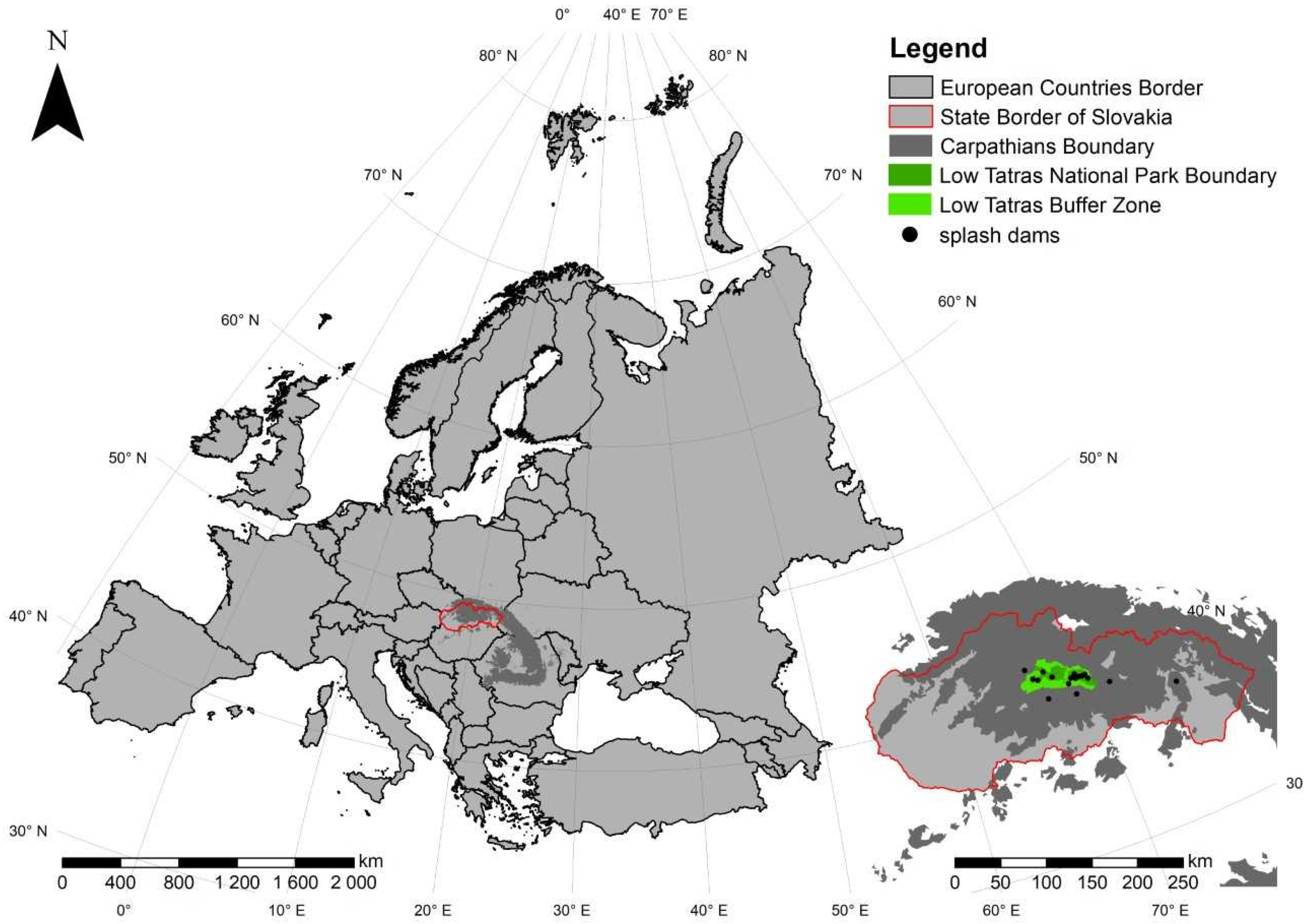
The Low Tatras National Park (NAPANT) is situated in the central part of the Western Carpathians (
Figure 1). It encompasses the summit section of the Low Tatras mountain range, which is the second-highest massif within the Carpathian arc. The asymmetrical arch of the main ridge, extending across central Slovakia, is markedly elongated along the west–east axis. The highest point of the range is Mount Ďumbier (2043 m a.s.l.). From the orographic perspective, the territory of the national park comprises primarily the Low Tatras but also includes adjacent parts of the Veľká Fatra Mountains, the Starohorské Mountains, the Zvolen Basin, the Horehronie Valley, the Podtatranská Basin, the Kozie chrbty Mountains, and the Spiš-Gemer Karst. The main ridge of the Low Tatras consists of a crystalline core formed predominantly by intrusive igneous rocks, chiefly granodiorites. Overlying this crystalline core are original (autochthonous) sedimentary formations that constitute its cover unit. These comprise a diverse assemblage of rocks such as shales, quartzites, and, within nappe structures, Gutenstein limestones and dolomites [
19,
20].
Until the 15th century, the original, predominantly beech and beech–fir primeval forests covered extensive areas of what is today the territory of the Low Tatras National Park, with the exception of the summit zones of the highest parts of the Chopok and Ďumbier massifs. The considerable size of the mountain range and the ruggedness of its relief allowed these primeval forests to preserve their natural character for a relatively long period. However, gradual settlement, the expansion of mining and metallurgy, and the associated timber extraction from the 13th century onwards, together with pastoralism developing from the 14th century, significantly accelerated the process of deforestation [
21].
By the 16th century—when the first splash dams began to be constructed—large parts of the present-day national park were already largely clear-cut [
22]. The function of the splash dams was to accumulate water to facilitate the floating of harvested timber from the upper valleys, where relatively undisturbed primeval forests still existed. The current species composition of the forests has been markedly influenced by artificial reforestation efforts dating from 19th century, when forest management began to emphasize the establishment of spruce monocultures.
At present, the foothill zones of the national park adjoining the basins are covered with markedly anthropogenically altered beech and fir-beech forests, bordered in warmer habitats by fragments of oak stands. Above this altitudinal zone extends a broad belt of spruce monocultures, which completely predominates eastward (in the Kráľovohoľské Tatras) and forms the upper forest limit at altitudes of 1500–1600 m a.s.l. On the rocky northern slopes of the range, Scots pine (
Pinus sylvestris) occurs sporadically. Above the forest line lies a belt of dwarf mountain pine (
Pinus mugo), gradually transitioning into anthropogenically created alpine meadows and pastures, occurring from approximately 1400 m a.s.l. [
23].
The Low Tatras National Park was declared by the Ministry of Culture of the Slovak Republic on 17 October 1978 [
24]. Today, it represents the largest national park in Slovakia, covering a total area of 205,085 ha, including its buffer zone. The core area occupies 72,842 ha, and the buffer zone extends over 183,004 ha [
25]. Approximately 11,000 ha of the most valuable territories are under strict protection (Protection levels 4 and 5).
The objects of protection in the Low Tatras National Park include ecosystems of deciduous, mixed, and coniferous forests, rocky habitats, wetlands, and meadows, as well as rare species of flora and fauna. Protection also encompasses unique components of abiotic nature, such as rock relief and hydrological systems. Recreation and leisure activities within the park are primarily based on soft forms of tourism, such as nature observation and appreciation, visual and educational experience of landscape features, active movement along official hiking and cycling routes, and nature and landscape documentation, particularly through photography [
26].
3. Literature Review
The literature review on the topic of splash dams and on methodologies for assessing the attractiveness of anthropogenic landscape features (including water reservoirs) in tourism forms the theoretical and methodological foundation of the historical-geographical research. Literature specifically dealing with splash dams, especially from a methodological standpoint, is relatively scarce—not only in Slovakia but also internationally.
A fundamental and irreplaceable source in this respect is the academic textbook by the German professor of mining Christoph Traugott Delius (*1728, Wallhausen—†1779, Florence), who taught at the Mining Academy in Banská Štiavnica, Slovakia. His textbook Anleitung zu der Bergbaukunst nach ihrer Theorie und Aushubung: nebst einer Abhandlung von den Grundsätzen der Berg-Kammeralwissenschaft für die Kaiserl. Königl Schemnitzer Bergakademie was first published in 1773 [
1,
2]. In several chapters, Delius provides a detailed analysis of the construction techniques of splash dams—from foundational works and dam engineering to their classifications, maintenance, and utilization. The text supplemented with several drawing and technical plans.
Internationally, the greatest attention to this subject has been given in Alpine countries, particularly in the German-speaking regions. A seminal work in this field is that of F. Hafner [
27], who provides a comprehensive overview of the construction techniques, classification, and use of splash dams in Austria from the 13th to the 20th century. Other important studies addressing the structure and utilization of splash dams across various Alpine catchments in present-day Austria, Switzerland, and Italy include works by H. Simmler [
28], H. Herold [
29], M. Agnoletti [
30], D. Vischer [
31], F. Idam and G. Kain [
32], T. Pamer, G. Neuhauser and A. Maier [
33], F. Idam [
34,
35], among others.
In the Bavarian Forest of southeastern Germany, splash dams were constructed from the 18th century onward and remained in use until the 20th century [
36,
37,
38]. From the 19th century and into the first half of the 20th century, splash dams were also built in northern Sweden and Finland, as well as in northwestern Russia on rivers flowing into the White Sea. A similar situation occurred in the United States, particularly in the states of Oregon, Washington, and Alaska [
39].
In recent years, renewed scholarly attention has been directed toward the study of splash dams in the Czech Republic, where such structures were constructed from the 16th century onward, primarily in the Krkonoše and Šumava Mountains and later in other Czech and Moravian highlands. Early regional historical research focusing on the mountainous core areas is represented by studies [
31,
39], which primarily emphasize the role of splash dams in timber floating and landscape transformation. Subsequent works expanded this focus to additional upland regions and incorporated more detailed archival analyses [
32,
39]. More recent studies have employed modern technologies, including GIS-based mapping and computer modelling, to document and visualize the relics of splash dams [
40,
41]. Advanced digital approaches to their spatial presentation and hydrological reconstruction are further developed in works of Pilous [
42,
43].
In Slovakia, a foundational but incomplete typology of historical water reservoirs according to their purpose was propose by M. Lukáč [
44]. A related thematic focus is addressed in the work of Abaffy et al. [
45]. Information on splash dams in Slovakia—including those in the Low Tatras—is generally fragmentary and appears only in a limited number of studies. The available literature further reveals a regional differentiation in research focus: several studies concentrate on the central part of Slovakia [
46,
47], while other contributions address splash dams and related water-management structures in the eastern part of the country [
48,
49]. However, as noted earlier, there is still no synthetic and comprehensive work that systematically examines splash dams across the territory of the Western Carpathians.
The methodology for evaluating the attractiveness of anthropogenic landscape features (including water reservoirs) for tourism draws on several sources. Polish cultural-heritage scholars K. Pawłowska and M. Swaryszewska [
50] proposed a noteworthy set of ten valuation aspects for assessing monuments in the landscape. With minor adjustments, these were clearly organized and published by the Polish geographer W. Cabaj in his paper Methods for Evaluating the Attractiveness of Anthropogenic Environments for Tourism Purposes [
51]. In Cabajs’ scheme, the attractiveness of an anthropogenic feature can be assessed using seven core and two supplementary criteria. This evaluative model was subsequently expanded by P. Rybár, founder of the Slovak school of geotourism [
52,
53]. Rybár employed ten primary assessment criteria (indicators), further subdivided into partial sub-criteria (i.e., partial indicators), to which he assigned numerical values on a scale from 0 to 8. The scoring system was constructed so that a higher total indicated greater attractiveness for tourism. In 2015, P. Rybár and Ľ. Štrba [
54] revised this scale by introducing recalculated, weighted values, thereby refining the relative importance of individual criteria.
Building upon these earlier works, a comprehensive methodology for evaluating the attractiveness of historical water reservoirs was developed and applied by B. Hrončeková Gregorová and P. Hronček [
4]. The valorisation was conducted using a point-based (scoring) assessment system, grounded in valorised indicators and their corresponding numerical values. The principle of this method lies in the selection of specific (valorised) indicators, each defined by certain characteristics, which are subsequently evaluated by assigning several points according to their qualitative level. The overall assessment methodology incorporated up to nineteen evaluation criteria, providing a complex and multi-dimensional framework for determining the attractiveness of historical water reservoirs.
A distinct evaluation methodology for assessing water reservoirs from the perspective of heritage conservation—which can, however, be modified by splash dams and their tourism-attractiveness assessment—was developed by the Czech researcher R. Račoch [
55]. This valorisation approach employs scaling methods, by which the evaluated criteria are divided into three groups. The first is the general evaluation criterion, which includes the assessments of the current condition, authenticity, and functional state—or overall authenticity of the reservoir. The second is the typological evaluation criterion, which encompasses the typological value of the reservoir, the value of its technological processes, and the systemic interconnections within its structure. The third, traditional evaluation criterion, comprises the architectural, artistic-historical, urbanistic, and structural values of the reservoir, as well as its historical and antiquity value. Each partial evaluation criterion is assigned a score ranging from 5 to 1, allowing for a comparative qualitative assessment of individual reservoirs and other historical water-management structures.
4. Methodology
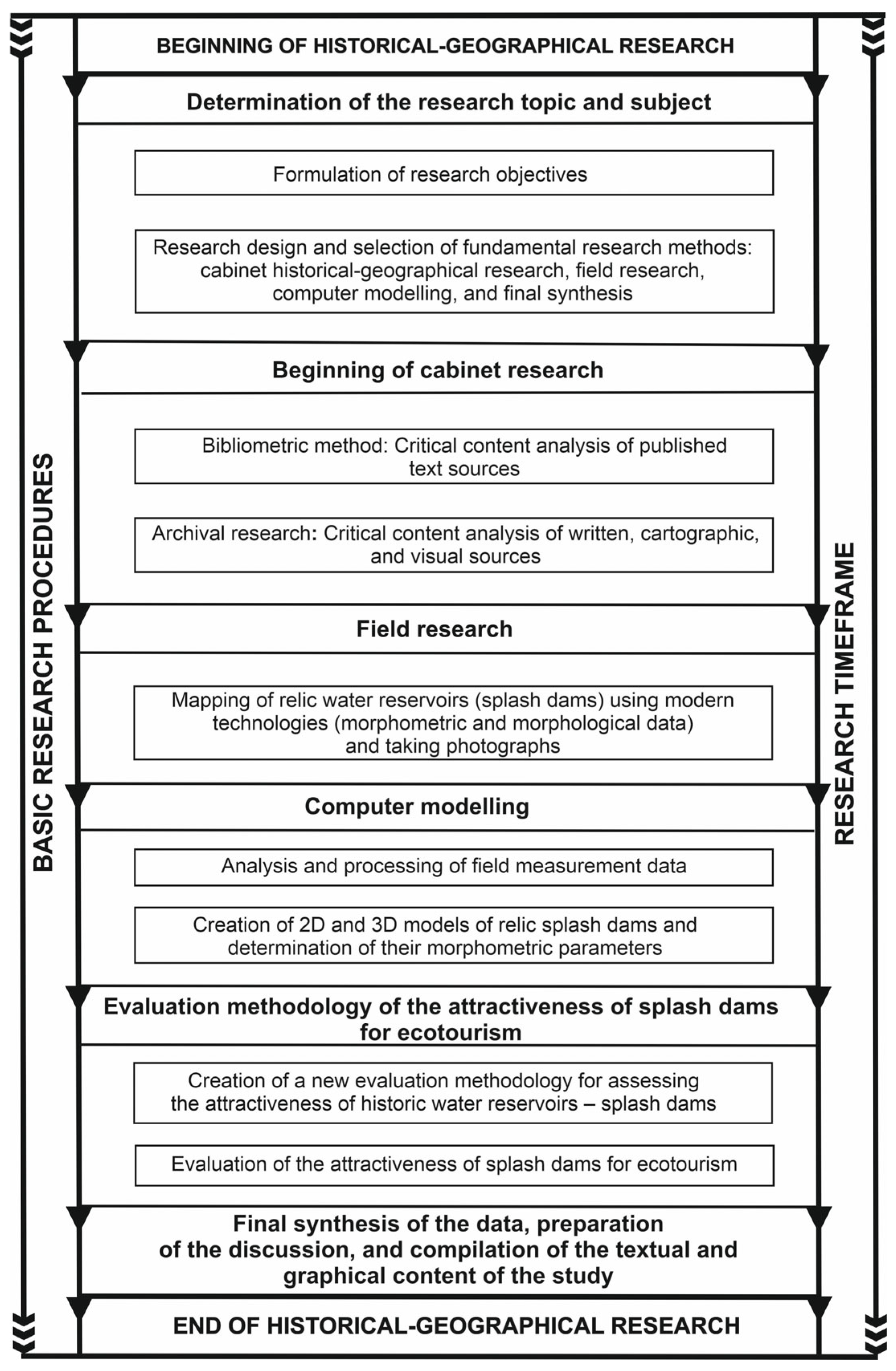
The long–term cabinet and field research consisted of several interrelated stages, for which methodological procedures were organized into four principal methodological frameworks. These were logically interconnected and implemented through a series of complementary methods, many of which were conducted concurrently. Together, they systematically contributed to achieving the research objectives and to processing the results into an original scientific study (
Figure 2).
The first step, following the formulation of research objectives and prior to the initiation of fieldwork, involved compiling a comprehensive literature review of the studied topic based on the bibliometric method [
56,
57,
58]. The complete review is presented in the concluding section of this study.
4.1. Methodology of Historical-Geographical Archival and Field Research
In the historical-geographical archival research phase, the most important step was the critical content analysis of archival sources [
59,
60], including both written and cartographic materials (as well as published references). Our direct critical content analysis of these sources—specifically those authored by Czech and Slovak researchers [
61,
62,
63] as well as foreign authors [
64,
65]—focused on the identification and subsequent localization of the investigated splash dams, along with their historical and technical descriptions. The most significant sources comprised old maps of various provenance and their analysis concerning the position and existence of splash dams within the historical landscape [
66,
67,
68].
In addition to cabinet-based historical-geographical research, field investigation constituted an essential part of the study [
69,
70,
71], conducted directly in connection with the findings derived from the analysis of written and cartographic sources. During fieldwork, the primary objectives were to identify, analyse, and map the relics of splash dam embankments [
72,
73,
74]. In general, the fieldwork was divided into two stages: a preparatory phase and the main field survey [
75].
Detailed field investigations employing modern cartographic and technical instruments focused on the application of established methodological procedures typical for morphological and morphometric mapping. The methodology for identifying the relief relics of splash dam embankments and the landscape traces of the studied historical anthropogenic reservoirs was based on the works of L. Zapletal [
76,
77], Z. Podgórsky [
78], P. Hronček et al. [
79,
80], P. Hrubý et al. [
81] and V. Pilous [
42,
43].
Field historical-geographical research was carried out between 2024 and 2025, and through systematic methodological work, we successfully located relics of all fourteen splash dams previously identified during the archival and bibliometric research. Fieldwork was conducted over a total of 11 days in 2024 (i.e., 21 May; 5–8 June; 15–18 July; and 18–20 August 2024) and 12 days in 2025 (i.e., 20–24 June; 4–6 September; and 10–13 October 2025). On average, this represents more than two days of intensive and systematic field research per site. For the purposes of this study, the size of the splash dams was chosen as the primary selection criterion. Accordingly, five of the largest structures were analysed in detail, serving as representative examples within the territory of the Low Tatras National Park.
Spatial data collection was performed using geodetic measurements with a Stonex S900 GNSS device operating in RTK mode (Stonex Srl, Paderno Dugnano, Italy), enabling centimetre-level accuracy in determining the spatial positions of dam crests, embankment bodies, and inflow and outflow structures of the splash dams [
82,
83]. Drone imaging was conducted to obtain high-resolution orthophotos and a digital terrain (DTM). Supplementary technical measurements were made with a Bosch Professional GLM 100-25 C laser rangefinder (Bosch Professional, Gerlingen, Germany), which was used to determine parameters such as crest height and width, dam length, body slope, and spillway gradient. The results of these measurements were subsequently verified by comparison with terrain models derived from LiDAR data. The aerial laser scanning (LiDAR) dataset from the Aerial Laser Scanning of Slovakia (LLS) program was processed by the Geodesy, Cartography and Cadastre Authority of the Slovak Republic (ÚGKK SR).
4.2. Methodology of 3D Modelling
The data collected during historical-geographical fieldwork enabled the creation of high-precision digital terrain models (DTMs) and the identification of subtle morphological features associated with the splash dams, such as transverse embankment bodies, outlet structures, and remnants of intake channels. The obtained data were processed and analysed in the Surfer 16 (Golden Software, LLC, Golden, CO, USA) and ArcMap 10.8 (ESRI ArcGIS, Redlands, CA, USA) software environments. In Surfer 16, elevation models and relief profiles of the dam structures were interpolated from LiDAR data and field measurements. These models were then used to calculate geometric parameters, including the volume and surface area of the reservoir. The length and width of the dam body, and the length and width of the accumulation zone.
All cartographic outputs and spatial analyses were processed in the S-JTSK coordinate system (EPSG:5514), the official geodetic reference framework of the Slovak Republic. During the processing and visualization of field measurements in Surfer 16, we followed the methodological framework described by Česák and Šobr [
84], which represents a standardized procedure for bathymetric lake mapping. This approach was adapted to the specific conditions of mapping historical water reservoirs (splash dams) in the Low Tatras. This methodology was selected for its high precision, transparency, and proven efficiency in processing geodetic and bathymetric data in Central European contexts.
In ArcMap 10.8, spatial analyses and cartographic outputs were generated, including the creation of vector layers representing technical features (dam, shoreline, inflow, and outlet) and the analysis of the landscape-ecological context of the splash dams based on Corine Land Cover (CLC) data from the Copernicus Land Monitoring Service. The CLC layers (version 2018, level 3) allowed the classification and quantification of surrounding land cover types, thereby enabling an assessment of the environmental context of each historical reservoir’s utilization.
Additional map compositions integrated layers of watercourses, hiking, and cycling trails, which were georeferenced and digitalized from the portal turistickemapy.cz [
85] and from the orthophoto map of Slovakia (2024) [
86]. All spatial data were subsequently integrated into a unified geodatabase, forming the foundation for the synthesis of the spatial relationships among the splash dams.
The outcome of this methodological historical-geographical process is a comprehensive geodatabase containing spatial, morphometric, and landscape data on the splash dams of the Low Tatras. This database enables the reconstruction of the original storage volumes and functional components of the splash dams, provides a basis for 3D modelling, and ultimately supports the evaluation of their attractiveness in terms of ecotourism development potential.
5. Results
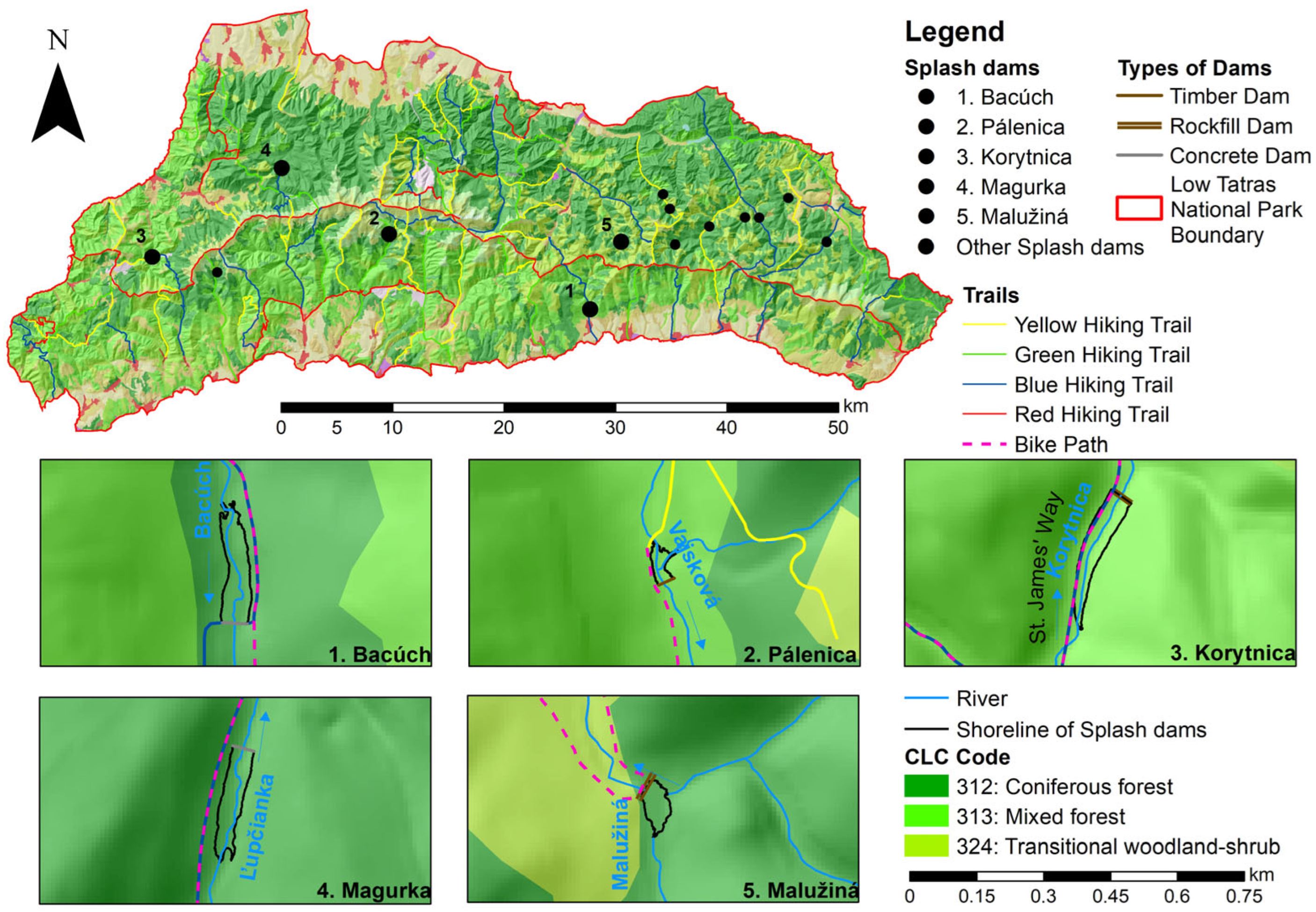
Our research confirmed the existence of fourteen splash dam relics within the national park (as documented also by historical cartographic sources), For the purposes of evaluating their attractiveness for ecotourism, we selected the five largest splash dams. Two of them—Bacúch and Pálenica (Vajkovská Valley)—are located on the southern slopes of the range within the Hron River basin, while three—Korytnica, Magurka, and Malužiná—lie on the northern slopes within the Váh River basin (
Figure 1 and
Figure 3).
5.1. Description of Historical Water Reservoirs—Splash Dams
5.1.1. Bacúch Splash Dam
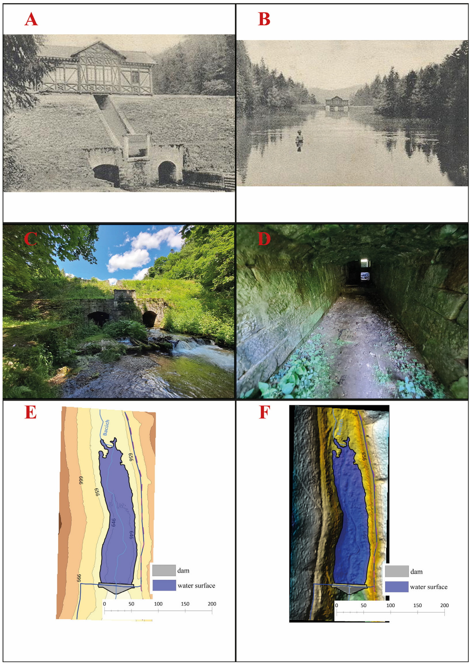
Bacúch Splash Dam (
Figure 4) is situated on the southern slopes of the Low Tatras in the valley of the Bacúšsky Stream, near its confluence with the Hron Valley from the right-hand side (cadastre of Bacúch, Polomka, Brezno District). The relic of the dam is surrounded by a mixed beech-spruce forest, while the former lake basin has gradually become overgrown with spontaneous tree vegetation. The site is easily accessible via well-maintained hiking trails. Near the dam, a notice board presents textual and pictorial information about the splash dam, the local mineral spring, and the remains of the former spa facilities. A marked blue hiking trail runs directly over the dam crest, connecting the village of Bacúch on the southern side of the Low Tatras with the village of Boca on the northern side of the range. Along the left side of the valley, following the line of the former lake, a marked cycling trail from Bacúch continues toward the end of the valley, where it joins the broader Low Tatras cycling network (
Figure 3).
At present, only the body of the original stone embankment of the dam has been preserved, partially reinforced with a concrete slab on the crest and the upstream slope. Beneath the outlet openings, remnants of wooden casing have survived in the streambed of the Bacúšsky Stream—originally built to prevent back erosion and undercutting of the dam during water discharge. The construction of the splash dam was carried out between 1881 and 1886 by forest master Adalbert Bedő. The dam was constructed of quarried stone, with the stone walls on the upstream and downstream faces connected every 3 m by transverse pillars, forming cells filled with compacted clay. A spillway was located in the centre of the dam crest, and two tunnel outlets were placed at the base. A small wooden control hut once stood atop the dam.
The splash dam served its original purpose—raising the water level of the Hron River to allow timber rafting from Bacúch to Banská Bystrica. Rafting took place every two to three days until 1942, corresponding to the time required to refill the reservoir. According to project documentation, the dam crest was 5 m wide, the base width 12 m, the maximum height between 9.85 and 12 m, and the total length 62.8 m. Historical records indicate a reservoir volume of 62,500 m
3 [
45,
87,
88].
Our field measurements enabled the creation of a 3D model of the Bacúch splash dam and the determination of its actual structural parameters. The dam crest lies at an elevation of 650 m a.s.l., the base width is 19.15 m, the height 9.7 m and total length 67.62 m. The reconstructed lake had a volume of 49,436.27 m
3 and a surface area of 13,030.33 m
2 (
Table 1).
5.1.2. Pálenica Splash Dam
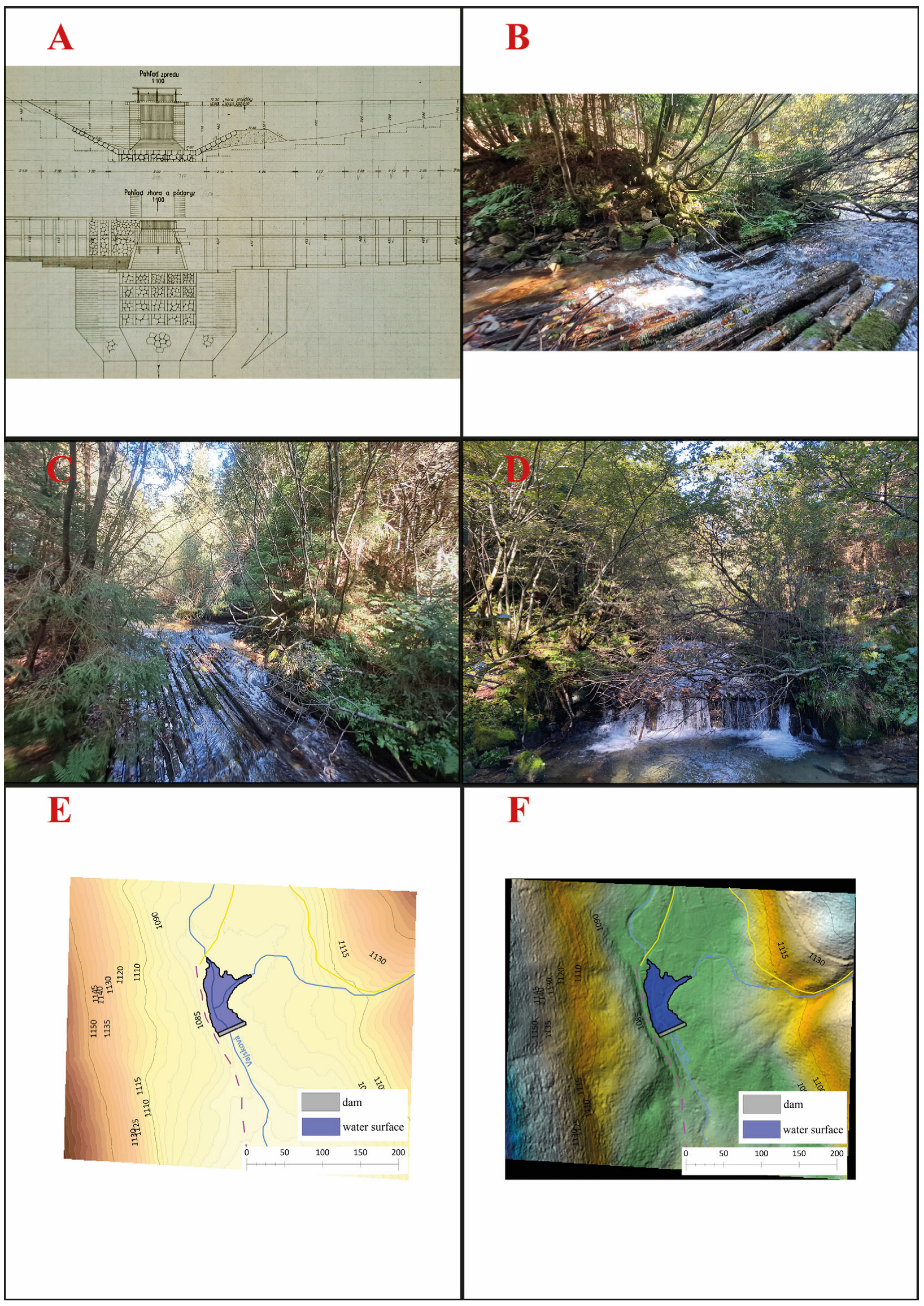
Pálenica Splash Dam (
Figure 5) is located on the southern slopes of the Low Tatras, at the upper end of the Vajskovský Stream Valley (cadastre of Dolná Lehota, Brezno District). The heavily damaged relic of the embankment dam lies within a spruce forest, approximately 100 m north of a small clearing where charcoal was historically produced. The site is easily accessible directly from the forest road that runs through the Vajskovská Valley, along which a green-marked hiking trail leads from the village of Dolná Lehota up to the Vajskovský Waterfall, situated beneath the main ridge of the Low Tatras (
Figure 3).
At the point where the dam crest meets the forest road, there is a small notice board with text and illustrations highlighting the relic of the overgrown embankment along the Vajskovský Stream. The locality Pálenica, whose name derives from historical charcoal-burning sites, is connected by a yellow-marked hiking trail that continues toward the ridge, where it joins the broader network of marked hiking routes. The educational trail “Vajskovská dolina”, established by the Forests of the Slovak Republic, also follows the green trail through the valley. The relic of the Pálenica splash dam forms the third stop on this trail, entitled “Pálenice—Timber Harvesting and Floating ”. The main notice board is located about 100 m north of the dam, in a deforested part of the valley. The site is also accessible via a marked cycling route from Dolná Lehota leading directly to the Pálenica splash dam.
The Pálenica Splash Dam was the last structure of its kind to be built within the Low Tatras National Park, constructed at a time when most other splash dams had already ceased to serve their original purpose. It was built as the simplest and most economical solution for managing the aftermath of a devastating windstorm that struck the upper Vajskovská Valley above the site. Between 1 and 3 September 1941, a severe windstorm swept across the Horehronie region, causing extensive damage to forest stands on the southern slopes of the Low Tatras. It uprooted large areas of forest in the upper part of the Vajskovská Valley, and the timber had to be processed as quickly as possible. Consequently, in 1943, a log-constructed splash dam with earth-rock embankment foundations was built at the end of the valley to allow the floating and economic utilization of the windthrow timber [
89].
The rapid construction was reflected in the technical simplicity and lower quality of the dam’s design. The foundations consist of loosely placed, unworked granite boulders up to one meter in diameter, covered with earth fill. According to archival documents (preserved in the archives of the State Forests of the Slovak Republic), the height of the embankment was 5.3, while the crest width at the spillway and outlet structure measured 5 m. The timber cribwork dam, constructed from unprocessed spruce logs, gradually narrowed toward the banks to a width of 4 m. The log framework was filled with stone and soil, and the total length of the dam reached 43 m.
Due to the extensive damage to the embankment, it was difficult to reconstruct all parameters of the structure based solely on field measurements. The crest of the dam lies at an elevation of 1078 m a.s.l., with a base width of 5.25 m, and a height of 5.30 m, and a length of 42.69 m. The reservoir volume was calculated at 2586.91 m
3, with a surface area of 2657.77 m
2 (
Table 1).
5.1.3. Korytnica Splash Dam
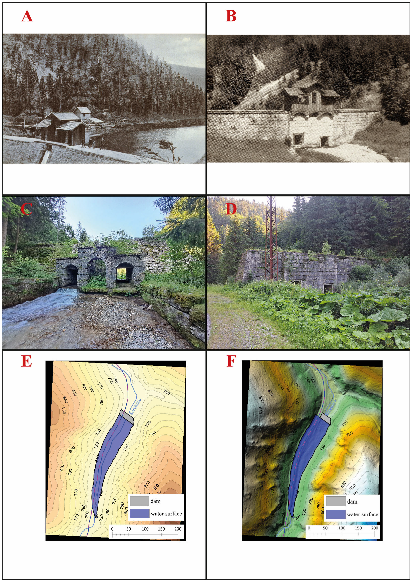
Korytnica Splash Dam (
Figure 6) is located in the lower part of the Korytnica Stream Valley (cadastre of Liptovská Osada, Ružomberok District), a right-hand tributary of the Revúca River, which itself flows into the Váh River. The site lies within the Low Tatras National Park, on the boundary between the Low Tatras (right/eastern side of the valley) and the Veľká Fatra Mountains (left/western side of the valley). The surroundings of the stone embankment relic are dominated by spruce monoculture forests, through which an open corridor of the main road runs along the Korytnica Valley. In 1959, a first-class road (I/59) from Banská Bystrica to the Polish border crossing at Trstená—part of the European road corridor E77 (from Pskov, Russia, to Budapest, Hungary)—was constructed directly across the former lake basin and the left side of the dam’s stone wall.
The splash dam occupies a strategically advantageous location near Donovaly, one of the main tourism centres of the Low Tatras National Park, situated only 3.5 km away. In addition to the aforementioned road, the site is directly connected to Donovaly not only by the Donovaly Cycling Route, but also by a yellow-marked hiking trail. Both routes are a part of the European pilgrimage route St. James Way, specifically the stage Liptovská osada-Donovaly. Approximately 450 m to the north, at the road junction leading toward the neighbouring Korytnica Spa, there is another marked cycling and hiking trail, which ascends from the spa to the main ridge of the Low Tatras.
Historically, from 1886 until the Second World War, the Korytnica Splash Dam served as a popular excursion destination for visitors of the nearby Korytnica Spa, offering opportunities for leisure walks, bathing, and boating. It was officially part of the spas’ network of promenades, which connected the splash dam to the spa park by a trail passing through the geomorphologically, hydrologically, and scenically attractive Nemcová Valley (
Figure 3).
As mentioned in the Introduction, the first written record of the Korytnica splash dam dates back to 1563, representing the oldest known historical reference to the existence of such a structure in the Western Carpathians [
5,
6]. The dam was originally a wooden log structure, constructed from spruce and fir logs. A splash dam at this location appears on old maps from 1753 and 1807. The same profile, showing the dam without a visible water surface, is also depicted on the Second Military Survey map from 1845. Another important cartographic source is the Map of the Orava and Liptov Counties (1851), which includes the water surface of the reservoir but does not label lit by name. In contrast, the Third Military Survey map (1876) omits the dam itself but labels the locality as Klause [
90].
The wooden structure likely ceased to function during the 1870s and had to be replaced. The Directorate of State Forests in Liptovský Hrádok decided to build a new splash dam with a stone embankment wall. Construction began in 1880 and was completed in 1882 [
91], when timber floating operations commenced. The dam remained in use until 1908, when the Ružomberok-Korytnica Forest Railway was opened. The reservoir still appears on a detailed topographic map from 1955 (scale 1:5000), showing the stone wall and water surface, although the locality is not named. The splash dam was destroyed in 1957 during the construction of the new first-class road I/59 [
92].
As no archival documents survived describing the dams’ parameters in detail, its dimensions and 3D model were reconstructed based on field measurements. The crest of the dam lies at an elevation of 740 m a.s.l., with a base width of 15.45 m, a height of 9.80 m, and a length of 56.35 m. The reconstructed reservoir volume was 32,327.68 m
3, with a surface area of 10,881.28 m
2 (
Table 1).
5.1.4. Magurka Splash Dam
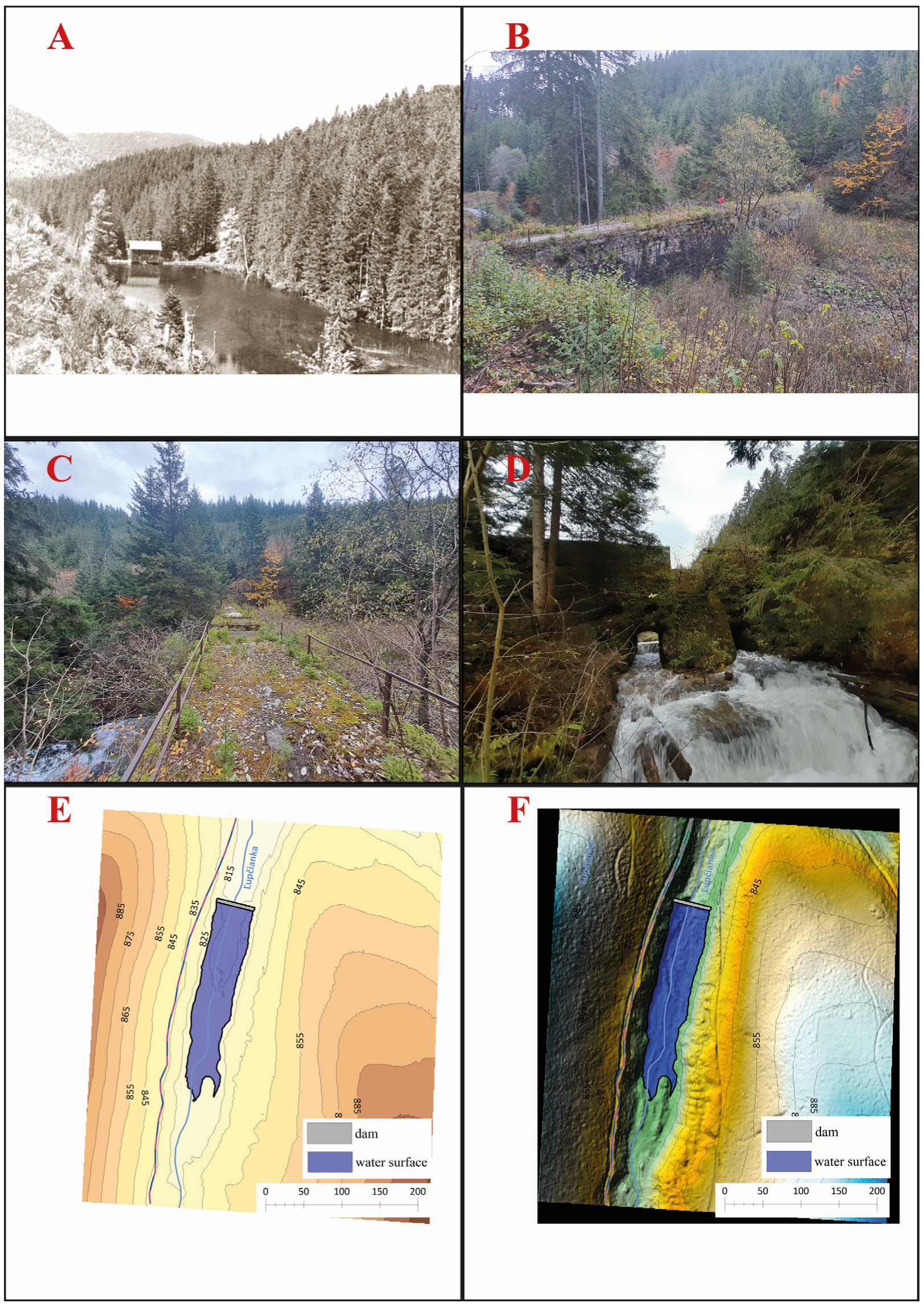
Magurka Splash Dam (
Figure 7) is situated in the upper third of Ľupčianska Valley (cadastre of Partizánska Ľupča, Liptovský Mikuláš District), approximately 500 m south of the confluence of the Tlstý Stream and Veľká Oružná Stream with the Ľupčianka River. The dam profile is located in a narrow section of the valley, positioned between the Tajch ridge on the right (eastern) side and the Hlinisko ridge on the left (western) side. The surroundings of the splash dam are covered by dense spruce forest complexes. The site is located about 500 m from the road junction leading to the historical mining settlement of Magurka, on the left side of the valley road. This road is part of a marked cycling route connecting Liptovská Lúžna (or alternatively Donovaly) and Partizánska Ľupča with the Magurka settlement. A blue-marked hiking trail also follows the same route toward Magurka, from which yellow and green-marked trails ascend to the main Low Tatras ridge. The same road, passing by the relic of the splash dam, is also part of the European pilgrimage route St. James Way, stage Partizánska Ľupča-Magurka (
Figure 3).
According to the archives of the Forest Compasorate and Land Community of Partizánska Ľupča, the first wooden-earthen embankment dam in the Ľupčianska Valley was allegedly built as early as the 16th century. However, archival records reliably document the construction of a wooden-earthen splash dam only in 1819, for the purpose of annual timber floating to Partizánska Ľupča. The relics of this structure are still visible approximately 5 m below the existing stone embankment, on both sides of the preserved wooden flume. The crib structure of the dam had an estimated base thickness of about 20 m, a length of approximately 45 m, and a height of around 8 m. This reservoir is depicted as a light-blue lake on the Second Military Survey map (1845) and labeled
Klause. On the Third Military Survey map (1876), the dam is again shown and named
Klause, while the locality is referred to as Na Teichu (“At the Pond”) [
90]. The splash dam was maintained and likely remained functional until the early 20th century, as in 1911, the Forest Compasorate of Nemecká (Partizánska) Ľupča built the current stone embankment dam. By 1938, maps already depict the site without the lake, using the Slovak toponym Tajch. The fact that the splash dam was most likely no longer in operation by the late 1930s and early 1940s is supported by an entry in the municipal chronicle of Partizánska Ľupča, which notes that timber from the Teich area was already being transported by carts. Maps produced after 1955 regularly show only the embankment structure without a reservoir.
The dam wall of the Magurka splash dam was built from quarried stone and reinforced on the crest with a concrete slab. Its height was 7.3 m on the upstream side and approximately 12 m on the downstream side. The crest length of the dam was almost 47 m, with a base width of 8 m and a crest width of 3 m. In the lower central section of the dam were two outlet openings vaulted with segmental arches, while in the upper central part was a spillway. To prevent back erosion below the outlets, the streambed was paved with stone, and its banks were reinforced with retaining walls approximately 30 m long. At the centre of the dam, there was originally a wooden shelter housing the mechanical device used to operate the outlet gates [
47].
Based on our field measurements and 3D modelling, the following parameters of the dam relic and the original reservoir were determined. The crest of the dam lies at an elevation of 820 m a.s.l., with a base width of 11.27 m, a height of 9.9 m, and a length of 54.3562 m. The reservoir volume was calculated at 38, 833.3 m
3, and its surface area at 10, 743 m
2 (
Table 1).
5.1.5. Malužiná Splash Dam
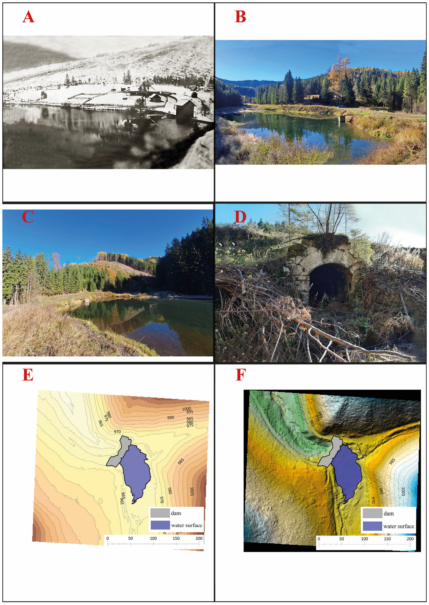
Malužiná Splash Dam (
Figure 8) is located at the upper end of the Malužinská Valley on the northern slopes of the Low Tatras (cadastre of Malužiná, Liptovský Mikuláš District), in the locality Pod Vrbicou, at the confluence where the Stratená Stream enters the Malužiná Stream from the right. The surroundings of the splash dam are dominated by spruce monoculture forests, although a large portion of these stands has recently been affected by clear-cutting. The site is accessible via an asphalt road running through the Malužinská Valley from the village of Malužiná. Two cycling routes pass along this road—the first ends at the locality Pod Vrbicou, near the splash dam, while the second continues across the embankment and follows a loop through forest roads back to Malužiná (
Figure 3).
The oldest known record of the existence of the Malužiná splash dam is found in the chronicle of the village Malužiná, which states that the dam was constructed in 1801. The existing splash dam is also depicted on a map held in the National Archives of Hungary (Reference code S 11-No. 636) from 1804, showing a light-blue lake with an unlabelled embankment. The Second Military Survey map (1839) also depicts the reservoir in blue and names the locality Na Teich (“At the Pond “). On the Third Military Survey map (1876), the locality is labelled Klause and clearly shows both the dam and the reservoir. It is highly probable that this was a wooden log-crib dam constructed from spruce roundwood, as confirmed by archival materials preserved in the Forestry and Timber Museum in Zvolen, Slovakia. The structure was rebuilt and maintained several times until 1923, when it was completely reconstructed. According to the village chronicle of Malužiná, the reservoir volume at that time was 45,000 m
3 [
93]. During this reconstruction, the original wooden dam was likely replaced within the same profile by a rock-earth embankment dam, built from material quarried directly at the dam site, approximately 50 m from the dam crest on its right side. The splash dam ceased to serve its original function of timber floating in 1930, when a forest railway was opened in the Malužinská Valley [
93].
Based on our field measurements and 3D modelling, we determined the basic parameters of the dam relic and the original reservoir. The crest of the dam lies at an elevation of 962.5 m a.s.l., the base width of the dam is 16.77 m, its height could not be precisely determined, and its length is 67.45 m. The reservoir volume could not be calculated because the basin is currently flooded, but its surface area was measured at 2426.55 m
2 (
Table 1).
Table 1.
Basic morphometric characteristics of the relics of historical dams and water reservoirs, obtained from field measurements and computer modelling. Source: authors.
Table 1.
Basic morphometric characteristics of the relics of historical dams and water reservoirs, obtained from field measurements and computer modelling. Source: authors.
| | | | | | Reservoir Volume | Dam (m) | Water Surface Area |
|---|
| | | | | | Volume | Area | Width | Length | Height | Length | Height |
|---|
| No. | Splash dam | Altitude asl | river | Type of dam | m3 | m2 | m |
| 1. | Bacúch | 650 | Bacúch | Concrete | 49,436.27 | 13,030.33 | 19.15 | 67.62 | 9.70 | 255.37 | 65.34 |
| 2. | Vajsková | 1078 | Vajsková | Timber | 2586.91 | 2657.77 | 5.25 | 42.69 | 5.30 | 97.19 | 36.22 |
| 3. | Korytnica | 740 | Korytnica | Rockfill | 32,327.68 | 10,881.28 | 15.45 | 56.35 | 9.80 | 321.38 | 54.35 |
| 4. | Magurka | 820 | Ľupčianka | Concrete | 38,833.3 | 10,743.49 | 11.27 | 54.35 | 9.90 | 260.45 | 50.25 |
| 5. | Malužiná | 962.5 | Malužiná | Rockfill | none | 2426.55 | 16,772 | 67.45 | none | 123.15 | 62.18 |
5.2. Development of a Methodology for the Evaluation of Attractiveness
The main objective of the evaluation was to determine the attractiveness of splash dams in terms of their potential for ecotourism development, using appropriately selected assessment criteria. The evaluation of attractiveness was conducted from multiple perspectives, employing an interdisciplinary approach to ensure the highest possible degree of objectivity. To achieve an objective assessment of splash dam attractiveness, it was also necessary to understand the historical context of their origin, construction, and utilization.
The assessment was carried out using a valorisation method based on point (score) evaluation. The scoring system is among the most frequently applied methodological approaches in evaluating the attractiveness of any element or phenomenon related to tourism [
94,
95,
96,
97]. Its principle lies in the selection of specific (valorised) indicators, each characterized by defined qualitative attributes, which are then assigned numerical point values according to their relative quality.
In this study, the selection of indicators was subordinated to the main research aim—evaluating the attractiveness of historical water reservoirs (splash dams) in relation to ecotourism development. We modified and supplemented the criteria used in several previous scientific works [
4,
50,
53,
95,
96,
98,
99,
100], extending them with additional criteria derived from field research findings and 3D modelling results. For analytical clarity, the evaluated indicators (assessment criteria) were classified into three categories: natural-environmental, technical and anthropogenic, and recreational-use criteria (
Table 2,
Table 3 and
Table 4). Each criterion and its specific characteristics were assigned a range of point values indicating their relative degree of attractiveness. The scoring ranges (scales) were determined based on the review of the above-cited literature, extensive consultation with experts, field observations, and modelling outcomes. If an assessment criterion carried greater significance in determining the overall attractiveness of a splash dam, the scale range was a set at 4-2-1. For criteria with lesser influence on attractiveness formation, a descending scale of 4-3-2-1 (or modified according to the number of attributes) was used. Based on the total number of points obtained, splash dams were then categorized into four attractiveness levels: low, medium, high, and very high in terms of their potential for ecotourism development.
5.3. Evaluation of the Attractiveness of Historical Water Reservoir Relics—Splash Dams
The valorisation represents a comprehensive approach combining historical, historical-geographical, cartographic, carto metric, and GIS methods, supplemented by field research and the authors’ subjective assessments based on their long-term experience in the study of this issue [
10]. Based on these methods, each splash dam was assigned a corresponding number of points for each evaluated indicator (
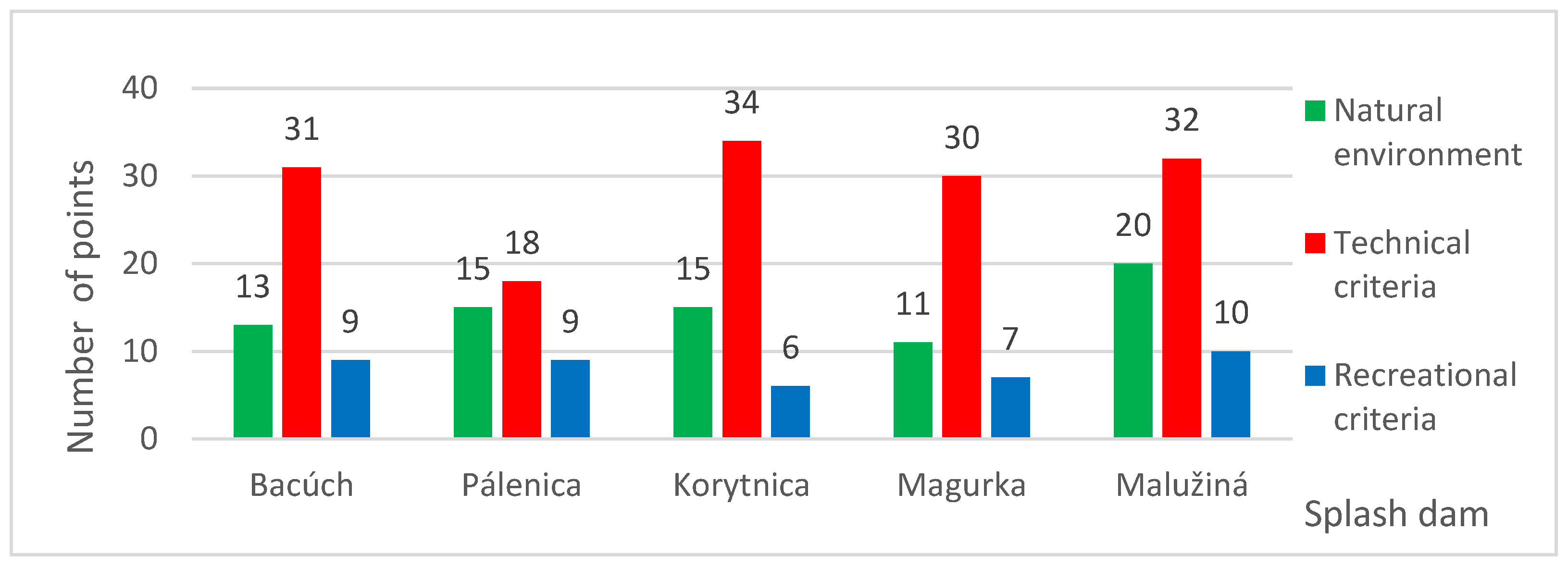
Table 5). The lowest total score within the assessment was 42 points (Pálenica splash dam), while the highest reached 62 points (Malužiná splash dam). The difference between the most and least attractive splash dam was therefore 20 points.
We subsequently established score intervals and assigned each interval a corresponding category of attractiveness level (
Table 6), with every water reservoir classified into one of these categories. The differences between the intervals represented a value of five points. Our results cannot be directly compared with the findings and conclusions of other studies, as no similarly focused research has been identified within the Western Carpathians region.
The lowest score was obtained by the Pálenica splash dam (only 42 points). In terms of criteria related to the natural environment, it achieved an average score. Although located in the forested upper section of a narrow valley—thus lacking open views of other landscape features—the surrounding high-mountain landscape possesses strong aesthetic qualities. However, a dramatic loss of points was recorded in the group of technical criteria (
Figure 9). It severely deteriorated condition, poor recognizability in the field, and inaccessibility due to dense riparian vegetation resulted in a total of only 18 points. In terms of recreational criteria, the reservoir again achieved an average score, as it is situated along both a hiking and an educational path (
Figure 3).
The Magurka splash dam shows a medium level of attractiveness. It has the lowest potential in terms of natural environment (
Figure 9). It is situated in a narrow valley section, surrounded by dense forest with no scenic views. Descending to it along the steep, successively overgrown banks is quite demanding. Within the group of technical parameters, it shows the second-lowest values. Although the dam is relatively well preserved, the reservoir itself is not water-filled and appears marshy. Better results were recorded for the group of recreational criteria, as a hiking trail, cycling route, and pilgrimage path pass directly above it (
Figure 3). In the broader recreational surroundings of the dam lies the former mining settlement of Magurka, which today functions as a high-mountain recreational centre offering accommodation and catering facilities.
A high level of attractiveness is demonstrated by two dams—Bacúch (53 points) and Korytnica (55 points). Both are situated in entirely different natural environments. While Korytnica lies in a narrower valley, adjacent to a main road and inaccessible from one side due to dense forest, Bacúch is located at the mouth of the valley, along a hiking trail in a picturesque setting (
Figure 3). Moreover, a natural mineral spring is situated nearby the Bacúch splash dam.
The Malužiná splash dam shows the highest level of attractiveness, and this for several reasons. It is the only one that remains water-filled, located in a well-preserved and visually appealing natural environment dominated by surrounding forests. It has well-preserved technical elements, including both the dam and the water surface itself (
Figure 9). Numerous recreational activities can be carried out in its vicinity, as it is located along a hiking trail and a cycling route (
Figure 3), and a recreational cabin has been built nearby.
If we understand ecotourism as a form of tourism in which visitors, either individually or in small groups, travel to attractive yet relatively unknown sites from a human perspective [
14], then splash dams can be regarded as such a category of technical heritage elements within the landscape. Moreover, these splash dams embody the very essence of ecotourism, as they are typically situated in ecologically preserved environments—such as, in our case, the Low Tatras National Park. Visiting them offers an engaging experience that combines the appreciation of nature with the discovery of cultural heritage that remains largely unfamiliar to most visitors, documenting the historical use of the landscape and shaping its identity [
16]. Since ecotourism emphasizes the importance of the natural environment, its cultural dimension, and their preservation, all three of these fundamental aspects and pillars are reflected precisely in the visitation of splash dams.
6. Discussion
Nevertheless, the study has several limitations that should be considered. The sample was limited to specific age groups and regional participants, which may reduce the generalizability of the findings to broader or international populations. The field walking tests were conducted under controlled conditions that may not fully capture range of environmental challenges encountered on actual forest hiking trails. Additionally, self-selection bias may have been present, as participants volunteered for testing, potentially overrepresenting more motivated or physically capable individuals. Physical fitness is also subject to temporal variation, and single-point assessment may not reflect long-term trends or seasonal fluctuations. Studies focusing on the mapping of splash dams have so far been conducted only to a limited extent. The topic has largely escaped detailed scientific inquiry across individual disciplines. The basic body of existing literature tends to concentrate on the inventory or identification of dam relics, or their brief historical- geographical characterization across various regions and mountains ranges, as outlined in the introduction and methodology of this study. Research employing field surveys combined with advanced technology and subsequent computer modelling remain rather exceptional.
Experts utilizing state-of-the-art digital technologies have instead focused on “tajchy”, i.e., historical reservoirs constructed for water accumulation as an energy source for mining and metallurgy. In Slovakia, such studies are primarily concentrated around the historic mining town of Banská Štiavnica, which, together with its hydrotechnical landscape system, is inscribed on the UNESCO World Heritage List. These studies were published by researchers led by K. Weis [
101,
102,
103,
104,
105,
106]. Similar analyses of historical dams, their mapping, computer modelling, and reconstruction have been conducted internationally [
41,
107,
108,
109].
Our two-year field investigations, methodologically grounded in the cited literature, demonstrate that field measurements of dam relics combined with computer modelling yield surprisingly accurate results, despite limitations inherent to terrain work (notably the significant degradation of dam remnants). This finding is further supported by comparison with historical written and cartographic sources. Nevertheless, the obtained data must be critically interpreted and compared with other references [
109], particularly when determining the morphometric parameters of original dams and reservoirs. Computer-based cartographic outputs and 3D models thus serve as essential tools to refine and enhance reconstructions of relics of vanished historical landscapes and their structures [
110,
111,
112]. In recent years, 3D modelling of significant features of historical has become a prominent component of international research [
113,
114]. Similar approaches are increasingly applied in the study of urban environments and their historical development [
115,
116,
117].
Within the field of cultural heritage preservation and restoration, digital technologies now play an increasingly vital role. Three-dimensional modelling allows not only for the visual reconstruction of vanished structures but also for the analysis of their original functionality and significance [
110,
111]. The implementation of reconstructed 3D models of splash dams demonstrates how modern technologies can contribute to preserving and revitalizing historical monuments. This process not only safeguards culturally important structures but also makes them accessible to both the public and scholars in digital form, thereby enhancing their relevance and impact on current and future generations—especially within soft forms of modern tourism, such as nature-based or ecotourism.
The outcomes of virtual reconstructions can be made accessible through notice boards equipped with QR codes, linking to interactive models accompanied by concise descriptions of each dam’s history, function, and historical significance. Moreover, digital databases can integrate information on the surrounding landscape, forest coverage, environmental protection, and technical-constructional solutions applied during their building. Such content offers visitors a comprehensive understanding of the historical appearance and importance of each splash dam.
Many relics of splash dams are situated in or near popular tourist destinations (for instance, Korytnica near Donovaly) and interact with their existing primary, secondary, and tertiary tourism infrastructure. All assessed splash dam relics are located along marked hiking or cycling routes within the Low Tatras National Park. For the further use and promotion of splash dams in ecotourism, it is essential to assess and determine their attractiveness in relation to natural (landscape) values, anthropogenic and technical evaluation criteria (concerning both the structure and its surroundings), and tourism-related criteria. These aspects form the foundation of our evaluation methodology presented earlier in this study. The method was based on a critical analysis of existing validated approaches used for assessing the attractiveness of cultural and technical heritage in the landscape.
Our analysis revealed that none of the existing methodologies could be directly applied to the evaluation of splash dams for soft tourism forms. They were either too focused on monument preservation or tailored to industrial heritage within mining tourism. Because splash dams situated in mountainous (mostly forested) terrain combine several unique features arising from their technical construction and environmental setting, we developed a custom evaluation methodology comprising three groups of criteria—landscape, technical, and tourism-related—each assigned specific point values. The higher the total score (
Table 2,
Table 3,
Table 4 and
Table 6,
Figure 9), the greater the attractiveness of the object in terms of ecotourism development potential.
The exemplary application of the author-developed evaluation methodology for assessing the attractiveness of relic of historical splash dams (dam embankments as well as reservoirs) within a forested landscape demonstrates its initial methodological validity and its potential for further refinement and practical application. Based on the evaluation, the following general conclusions were drawn:
Relics of splash dam embankments that are partially or at least minimally water-filled can be considered attractive. The preservation of a lake, which introduces numerous romantic elements into a mountainous landscape, significantly enhances attractiveness.
The attractiveness of relics increases when they are located in the upper reaches of mountain valleys and when their surroundings provide at least partial viewpoints.
Attractiveness further increases when the surrounding area is covered by mature, near-primeval forest, regardless of species composition. By contrast, attractiveness decreases markedly where the surroundings are overgrown by dense juvenile successional vegetation.
From a visitor perspective, attractiveness also increases when other landscape attractions—natural or anthropogenic—are located in the immediate vicinity of splash dam relics (e.g., mineral springs, forest lodges offering public accommodation, mining relics, other technical monuments, rocky landforms, etc.)
If a splash dam is no longer water-filled, its attractiveness is significantly enhanced by the technical design and structural complexity of the dam relic. Some stone embankments can also be visited from within the dam body via spiral staircases or by passing through accessible discharge structures.
Accessibility is a key factor influencing visitation. Although accessibility itself does not directly increase attractiveness, it significantly affects visitor numbers. Many relics are situated directly along marked hiking or cycling trails, which often run directly along the crest of the dam, thereby directly enhancing their attractiveness.
Visitor attractiveness is also strongly influenced by access to historical-geographical and hydrotechnical information about the visited splash dam. Therefore, the installation of stationary notice boards (either as standalone elements or as part of educational trails), or QR codes, is important for enhancing attractiveness. However, the effectiveness of QR codes is significantly limited by the lack of a mobile internet signal in mountainous environments.
Specific conclusions derived from the evaluation of the attractiveness of splash dams within the forest landscape of the Low Tatras National Park:
The Malužiná splash dam achieved the highest score and is therefore the most attractive for ecotourism. High attractiveness was also recorded for Bacúch and Korytnica, while Magurka exhibited medium attractiveness and Pálenica the lowest. Overall, splash dams represent valuable destinations for ecotourism, fulfilling its core principle—experiencing and interpreting the landscape, particularly in areas of high natural and cultural value. These structures provide authentic experiences rooted in the cultural-historical legacy of past livelihoods, merging natural and cultural dimensions of the landscape [
17].
In terms of the preservation of technical elements, the most attractive sites are Korytnica, Bacúch, and Magurka, where stone embankments have been preserved in relatively good condition.
Regarding the proximity to official hiking and cycling routes, the Korytnica splash dam achieved the highest rating.
From the perspective of forest landscape aesthetics, the Malužiná splash dam is located in the most visually appealing mountainous scenery.
The lowest level of attractiveness was recorded for the Pálenica dam relic in the Vajskovská Valley, due to its extensive structural damage and advanced forest succession in the surrounding area.
Splash dams represent important technical monuments that form a significant part of cultural and historical heritage. Owing to their exceptional character, expressed through the sensitive integration of these structures into the mountain landscape, they constitute attractive and sought-after sites in terms of visitor interest. The symbiosis between the forested mountain environment and hydraulic engineering works creates a distinctive form of cultural landscape. The cultural landscape, or the cultural component of the landscape, represents the fourth pillar upon which ecotourism developed in the European geospace is based, which is consistent with our previous research [
118].
The environmental pillar of ecotourism refers to environmentally responsible travel by individuals or small groups to destinations that are little known and insufficiently explored. Splash dams and their remnants are typical examples of such little-known structures, whose existence is largely unknown to tourists, as their original role and function were significant mainly in the past. Today, they persist primarily as technical monuments or, in some cases, as water bodies used for recreational water activities.
The social pillar of ecotourism is linked to movement through both natural and cultural landscapes and their observation, resulting in an authentic experience of nature and landscape appreciation. Ecotourism develops in a sustainable manner and therefore minimizes negative impacts on the natural, social, and cultural environment, with the aim of preserving natural and cultural diversity as well as the identity of the landscape. Since ecotourism is non-mass in character, it is economically more efficient in relation to local communities (rural settlements), as it is largely ensured by local service providers [
16]. It offers local communities alternative income opportunities and increases awareness in line with the protection of natural and cultural landscape values and the technical monuments located within it. In this way, ecotourism also fulfils the third pillar, namely the economic pillar.
Water-filled splash dams, similarly to natural lakes, represent sites with high potential for ecotourism even within cultural landscapes, as supported by numerous studies [
119,
120,
121,
122,
123]. Therefore, assessing the attractiveness of (historical) anthropogenic lakes is essential for their potential future development. This is also indicated by our results, although they should currently be regarded only as a pilot-scale. Further research is needed to address potential methodological limitations and refine the evaluation framework. In upcoming stages, we plan to conduct historical-geographical reconstructions and attractiveness assessments of all known 14 historical splash dam relics in the Low Tatras, followed by the entire Western Carpathians region, where over 30 relics have already been identified in Slovakia alone.
7. Conclusions
The Low Tatras mountain range was the first area in the Western Carpathians where splash dams were constructed for timber floating, beginning in the 16th century. They were built on both the southern and northern slopes, predominantly in the upper sections of side valleys. After the establishment of the Low Tatras National Park in the 1970s, the relics of these structures became part of the park’s heritage. Together with mining remains, they represent valuable anthropogenic elements complementing the park’s natural uniqueness.
Splash dams have been almost completely forgotten in the context of ecotourism development, and no substantial scientific research has yet focused on them. Based on archival and literary sources, we identified 14 splash dam relics within the park, which were precisely located in situ during field surveys.
For the sake of clarity, the sites have been divided into three geographical areas. On the southern slopes within the Hron River basin, in the Bacúšska Valley, lies the Bacúch splash dam (within the cadastral territories of Bacúch and Polomka). In the Vajsková Valley, the Pálenica splash dam has been identified (cadastral territory of Dolná Lehota), and in the Sopotnická Valley, in the locality known as Tajch, there is the dam of the Sopotnická splash dam system (cadastral territory of Brusno).
In the western part of the national park, situated on the northern slopes of the Ďumbier Tatras within the Váh River basin, the Korytnica splash dam is located in the Korytnica Valley (cadastral territory of Liptovská Lúžna), while the Magurka splash dam is situated in the Ľupčianka Valley (cadastral territory of Partizánska Ľupča).
In the eastern part of the national park, on the northern slopes of the Kráľova Hoľa Tatras, there are nine splash dams within the Váh River basin. In the Malužinská Valley, in the locality below Vrbica, lies the Malužinská splash dam (cadastral territory of Malužiná); in the Svarín Valley there are two structures—the Lower Svarín and Upper Svarín splash dams—in the locality of Torysa (cadastral territory of Východná); in the Ipoltica Valley, the Medvedie splash dam is located in the valley of the right-hand tributary Medvedí Stream; the Ipoltica splash dam in the locality of Lacková; the Hoškova splash dam in the left-hand Hoškova Valley in the locality of Snežná; and the Dikula splash dam in the valley of the right-hand tributary Dikula in the locality of Tajch (cadastral territory of Východná). Furthermore, the Kremeniny splash dam is situated in the Benkovský Stream Valley, and the Ždiar Valley (cadastral territory of Liptovská Teplička).
In recent years, increasing attention has been devoted to the secondary use of the remnants of historical splash dams in the Low Tatras National Park and in the adjacent mountain ranges. These structures are not only becoming attractive destinations for ecotourism, but among conservationists, hydrologists, and forestry professionals, the idea of their restoration has gained significant resonance. The proposed uses include their adaptation as fire-prevention reservoirs (for example, the splash dam in the Ľubovnianska Valley in the Veľká Fatra Mountains), as ecological sites and fishponds (for instance, the Klauzy splash dam in Slovak Paradise National Park and the Hrončok splash dam in the Vepor Mountains), or as reservoir for flood-control measures.
This issue has been extensively addressed in the Czech Republic by prof. B. Janský [
117,
124], who perceives the potential of splash dam restoration not only in the form of conventional water reservoirs, but also as dry or semi-dry polders. Such systems would create retention spaces designed for the temporary storage of flash-flood runoff following intense rainfall events. Polders can also serve as pastures, and in their semi-dry variants as natural wetland habitats, thus contributing to enhanced ecological stability and biodiversity within the landscape. Currently, projects of this nature are being prepared by the State Forests of the Slovak Republic, including the restoration of the Malužiná splash dam and the reconstruction of the Šaling splash dam on the Čierny Hron River in the Vepor Mountains.
The results and conclusions of our research indicate that all individual partial objectives of the study, which together constitute the fulfilment of the main objective, were successfully achieved. It can be stated that the appropriate methodological integration of historical-geographical desk-based and field research, supplemented by 3D computer-generated outputs, provides a sufficient body of relevant and valid information for the evaluation of the relics of historical splash dams using the methodology developed by the authors. It is evident that these evaluations generate an adequate empirical basis for the reliable assessment of the attractiveness of these relics and create the prerequisite for the application of the proposed methodology in further research on these distinctive landscape features in the Western Carpathians, within the context of the relatively new and dynamically developing form of tourism, namely ecotourism.